geochemical signature of earthquake-induced surface ...buried atlantida deposit, northern chile....
TRANSCRIPT
Geochemical signature of earthquake-induced surface flooding by mineralized
groundwater over the buried Atlántida Deposit, northern Chile
Abbreviated title: Geochemistry of saline pockets above Atlántida
A. E. BROWN1*, P. A. WINTERBURN
1,2 & T. BISSIG1,3
1Mineral Deposit Research Unit, Department of Earth, Ocean and Atmospheric Sciences, University of British Columbia, 2020-2207 Main Mall, Vancouver, B.C., V6T 1Z4, Canada
2Current address: Vale Exploraciones Chile, Rosario Norte 615 #1202, Las Condes, Santiago, Chile
3Current address: Goldcorp Inc., 666 Burrard St #3400, Vancouver, B.C., V6C 2X8, Canada
*Corresponding author (e-mail: [email protected])
Abstract
At the buried Atlántida deposit (Cu-Au-(Mo)) in the Atacama Desert of Chile, highly saline
pockets of fine-grained material 10 cm – 3 m in diameter were identified on the alluvial
surface using remote sensing and detailed regolith mapping. The median salinity (NaCl
dominant) of the saline pockets is 2.2% compared to background alluvial material with a
median salinity of 0.01%. Their distribution along mapped fault structures and the highly
saline nature of the material suggest they form as an expression of groundwater forced
through fractures to the surface during seismic activity. A targeted geochemical survey,
oriented parallel to the orientation of the structures (sample spacing 250 m along structural
trend) specifically sampling saline pockets on relatively old surfaces, was performed over the
deposit. Deionized water extraction of soluble salts and analysis by ICP-MS revealed strong
correlations of increasing salinity and increasing concentrations of porphyry copper
pathfinder elements. Elevated responses of Se, Mo, Re, and Te normalized to a groundwater
volume proxy are present directly over the Atlántida deposit. This suggests the rate of erosion
and sedimentation is slow enough in the Atacama Desert to preserve surficial anomalies as
saline pockets, formed by periodic seismically induced surface flooding of groundwater along
faults extending to surface. Targeted sampling of saline pockets along structural trends using
weak leach geochemistry in terrains dominated by transported cover can serve as a routine
exploration method for the potential discovery of buried copper porphyries, and other styles
of mineralization in the Atacama Desert of Chile.
Keywords: exploration, buried deposits, geochemistry, geomorphology, selective leaches,
earthquake-induced surface flooding, seismic pumping, saline pockets, Chile
by guest on February 9, 2020http://geea.lyellcollection.org/Downloaded from
Manuscript version: Accepted Manuscript This is a PDF of an unedited manuscript that has been accepted for publication. The manuscript will undergo copyediting,
typesetting and correction before it is published in its final form. Please note that during the production process errors may be discovered which could affect the content, and all legal disclaimers that apply to the journal pertain.
Although reasonable efforts have been made to obtain all necessary permissions from third parties to include their
copyrighted content within this article, their full citation and copyright line may not be present in this Accepted Manuscript version. Before using any content from this article, please refer to the Version of Record once published for full citation and
copyright details, as permissions may be required.
Accepted Manuscript
Geochemistry: Exploration, Environment,
Analysis
Geochemical signature of earthquake-induced surface
flooding by mineralized groundwater over the buried
Atlántida Deposit, northern Chile
Alexandra Brown, Peter A. Winterburn & Thomas Bissig
DOI: https://doi.org/10.1144/geochem2018-065
Received 26 August 2018
Revised 20 February 2019
Accepted 21 February 2019
© 2019 The Author(s). This is an Open Access article distributed under the terms of the Creative Commons Attribution 4.0 License (http://creativecommons.org/licenses/by/4.0/). Published by The Geological Society of London for GSL and AAG. Publishing disclaimer:
www.geolsoc.org.uk/pub_ethics
To cite this article, please follow the guidance at http://www.geolsoc.org.uk/onlinefirst#cit_journal
ACCEPTED MANUSCRIPT
by guest on February 9, 2020http://geea.lyellcollection.org/Downloaded from
Porphyry copper deposits are significant contributors of Cu, Au and Mo to the global
economy, yet discoveries of large, economically viable deposits in the last 20 years have
declined (Kelley et al. 2010). Development of new strategies and practical methodologies to
detect and target porphyry copper deposits buried under transported cover is key to future
discoveries. The Atacama Desert of Chile hosts some of the largest porphyry copper deposit
clusters in the world, such as Chuquicamata, Escondida and Collahuasi. However, discovery
of new deposits has been hindered by the thick sequence of Neogene and Quaternary gravels
which cover large areas of the hyper-arid desert (Fig. 1).
Porphyry copper deposits show both structural control of porphyry emplacement and
mineralization at shallow depth (Sillitoe 2010). In tectonically active areas, such as Chile,
fault structures are activated both as seismic sources, and by movement along the structure as
a result of seismic activity nearby. Movement along these faults may extend through the
unconformably overlying partially consolidated or unconsolidated gravels.
Geochemical anomalies hosted in gravels above buried porphyry copper deposits in the
Atacama Desert such as Spence (Cameron & Leybourne 2005), Mantos Blancos (Palacios et
al. 2005), Radomiro Tomic, Mansa Mina (Cameron et al. 2010), and Gaby Sur (Cameron et
al. 2004) have been characterized by elevated concentrations of salt (NaCl) and porphyry
copper pathfinder elements (Cu, Mo, Re, Se, As). The formation of geochemical anomalies
has been interpreted by Cameron et al. (2002) as resulting from the leaching of soluble and
mobile elements by groundwater interaction with mineralization, followed by the transport of
groundwater enriched in trace elements to the surface by earthquake-induced pumping
through fracture zones extending through overlying gravels. Geochemical anomalies formed
by these processes therefore only occur where deep bedrock faults extend through overlying
gravels to the surface (Cameron et al. 2004; Cameron & Leybourne 2005; Palacios et al.
2005; Cameron et al. 2010). Strong structural control over both large-scale porphyry
emplacement and geochemical anomaly formation on the surface emphasizes that the
identification of bedrock structures continuing through gravel cover is key for effective
exploration strategies in the Atacama Desert.
At the buried Atlántida Cu-Au-(Mo) porphyry located 55 km NNE of Copiapó, Chile (Figs.
1, 2) detailed regolith mapping using remote sensing revealed distinct geomorphic features
on the alluvial surface produced by active structures (Brown et al. 2019 this issue). Highly
saline pockets of material were identified on the alluvial surface adjacent to the structures in
the oldest gravel surfaces. The pockets are 10 cm – 3 m in diameter with median salinity
(NaCl dominant) of 2.2% (n=138) compared to the median background salinity of alluvial
material (0.01%, n=196). The pockets have distinct physical characteristics relative to the
surrounding alluvial material (Brown et al. 2019 this issue), and are restricted to along fault
structures extending to surface. Such fault structures are identified using geomorphic
markers, such as changes in alluvial fan morphology as a result of fault movement post-
gravel deposition. Saline pockets are interpreted to represent the expression of the effusion of
groundwater at the surface by seismic pumping (Brown et al. 2019 this issue) (Fig. 3). This
study reports results from a geochemical survey at the Atlántida deposit, where sample lines
were oriented along trend of fault structures across the project area and targeted saline
pockets as the sampling material.
Geology of the Atlántida Deposit, Atacama Region, Chile
District Geology
Atlántida is a porphyry-skarn Cu-Au-(Mo) deposit located 55 km NNE of Copiapó, Region
III (Atacama Region), Chile (Fig. 2). The property (~12 km2), previously explored by First
ACCEPTED MANUSCRIPT
by guest on February 9, 2020http://geea.lyellcollection.org/Downloaded from
Quantum Minerals Ltd., is currently owned by Minera Atlántida. Atlántida is located between
the Atacama and Domeyko fault systems within the southern extent of the Central Depression
of northern Chile (Bissig & Riquelme 2010). The porphyry is part of the Late Cretaceous
porphyry copper belt (Maksaev et al. 2010), including the Inca de Oro mine located 25 km
NNE of the Atlántida deposit (Fig. 2). District geology in the Atlántida region is summarized
as comprising dominantly of Cretaceous carbonaceous limestone sequences and Jurassic to
Paleocene volcanic and volcano-sedimentary packages younging to the east (Matthews et al.
2006). Miocene to Quaternary gravels fill valleys between outcrops.
Deposit Geology
Transported alluvial gravels (25 m – 80 m thick) cover the entire porphyry Cu-Au
mineralized zone (Fig. 2). Gravels at Atlántida cover a thin, weakly developed discontinuous
leach cap characterized by limonite and hematite, however, no supergene mineralization has
accumulated as a result of these leaching processes and sulfides are not reported close to the
bedrock gravel interface (Hope & Andersson 2015; Pizarro 2016). Economic mineralization
at Atlántida is reported as 100% hypogene and occurs 200 m below the gravel-bedrock
contact, extending to at least 600 m below the surface as defined by drilling. Mineralization
occurs in association with disseminated and vein-hosted pyrite, with chalcopyrite as the main
ore mineral, and minor molybdenite. Mineralization is reported with average grades of ~0.2%
Cu and 0.34g/t Au inclusive of the local skarn with a preliminary resource estimate of 427.1
M tonnes (Hope & Andersson 2015).
Two main intrusive phases are host to the bulk of mineralization and intrude into volcanic
and limestone units. The earlier intrusive phase is tonalitic in composition and is interpreted
as pre-mineralization (Hope & Andersson 2015; Pizzaro 2016). This phase is intruded by a
feldspar-rich granodiorite porphyry, causing brecciated contact zones and highly brecciated
areas within the tonalite intrusion (Fig. 4; Hope & Andersson 2015; Pizzaro 2016). Local
skarn and carbonate replacement polymetallic veins are exposed in the limestone outcrops
east and west of the buried porphyry.
Faults mapped in outcrop generally trend N-S, while cross-cutting faults, mainly oriented
SW-NE and NNW, occur within the deposit area and control the emplacement of the
porphyritic stocks. A SW-NE-trending fault, interpreted as a transfer fault, creates a large
valley (Fig. 2) and cross-cuts the porphyry. These cross-cutting faults can be identified by
remote sensing (Brown et al. 2019 this issue) and in aeromagnetic data (Fig. 4; Hope &
Andersson 2015).
Alluvial cover
Gravel cover generally deepens from north to south, with depths ranging from 25 - 80 m. The
water table is variable across the property, generally located at 40 – 50 m below the surface.
The alluvial surface consists of unconsolidated gravels of clastic material below a cobble
surface with varying occurrences of hard or soft calcrete, generally encountered at 20 - 40 cm
depth. Gravel fragments on the current surface covering the deposit, are dominated by
andesite, derived from outcrops located 1.5 – 3 km north and south of the deposit,
respectively (Fig. 2). Gravel fragments dominated by skarn derived from the limestone
outcrops east and west of the deposit do not overlie the deposit. The alluvial surfaces lack the
common gypcrete and soluble nitrate horizons more commonly found in the northern
Atacama Desert.
ACCEPTED MANUSCRIPT
by guest on February 9, 2020http://geea.lyellcollection.org/Downloaded from

Field Methodology
High-resolution drone imagery (8 cm horizontal resolution) and a digital elevation model (1
m resolution) (Brown et al. 2019 this issue), were used for detailed regolith mapping, and
mapping of reactivated bedrock fault structures extending to, and altering alluvial landforms
on, the surface. Field based conductivity measurements on slurries (see below) aided in
identifying the saline pockets.
Samples were collected on lines parallel to SW-NE and N-S structural trends (Fig. 2).
Regolith maps combined with field assessment were used to ensure samples were taken on
the oldest alluvial surfaces, and maintained consistent background chemistry by following
alluvial fans dominated by specific lithologies. Short sample lines with up to 4 samples
spaced at 25 m to 50 m were collected perpendicular to the structural trend. Sample lines
were spaced at 250 m. The peripheral samples along the lines are located up to 150 m away
from the main fault zone (Fig. 2). To evaluate background responses, the two sample lines
(SW-NE and N-S) were extended up to 2 km away from the area of buried mineralization
(Fig. 2).
Saline pockets were specifically targeted for sampling. The upper 5 cm of the pockets were
removed to avoid contamination by windblown dust. Samples were extracted from the top 5-
30 cm of the material within the pockets, taking care not to sample the adjacent gravel, using
nylon tools, and were sieved to <180 µm in the field. Measurements of electrical conductivity
in slurries (1:1 deionized water to soil by volume) were performed in the field. Measurements
of pH in slurries (1:1 deionized water to soil by volume) were subsequently performed at the
University of British Columbia, Canada. Certified reference material along with field
duplicates taken from 2 adjacent sample sites, were inserted every 20 samples.
Analytical Methodology
Analytical methods utilized are summarized in Table 1. Samples were analyzed at Bureau
Veritas Ltd. in Vancouver, Canada. One gram of sample was leached with 20 g of deionized
water at room temperature (20°C). The sample was centrifuged and the leachate analyzed by
ICP-MS. Select samples were analyzed by sequential leach analysis at ALS Laboratories Ltd.
in Vancouver, Canada. Further select samples were analyzed at Bureau Veritas Ltd. in
Vancouver for organic carbon by combustion furnace and infrared absorption after extraction
of carbonate; and by hot hydroxylamine hydrochloride/ICP-MS. X-ray diffraction was
undertaken at EOAS, University of British Columbia, Canada.
Results
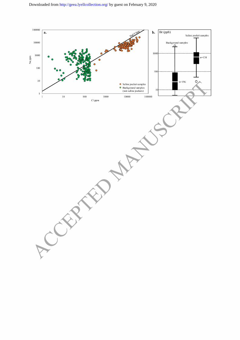
Trace element concentration in saline pockets by deionized water leach ICP-MS
Deionized water leach analyses of samples from saline pockets show elevated concentrations
of Na, Cl (Fig. 5a) and Br (Fig. 5b) compared to samples of low-salinity alluvial material.
The Br response is similar to that observed in groundwater at the Spence Deposit (Leybourne
& Cameron 2008). The high salinity dominantly reflects halite (NaCl) (Fig. 5a) as confirmed
by XRD analyses of twelve samples. XRD analysis of salts, precipitated from the deionized
water leachate of saline pocket material by evaporation, indicated the presence of halite,
calcium nitrate, and calcium chloride. XRD analysis also showed calcite which likely
precipitated from aqueous calcium bicarbonate in the leachate (Reddy et al. 1981).
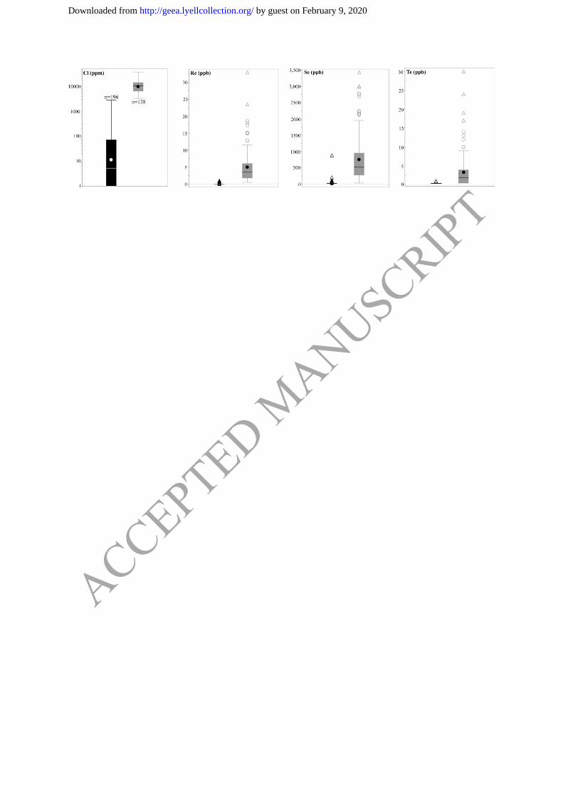
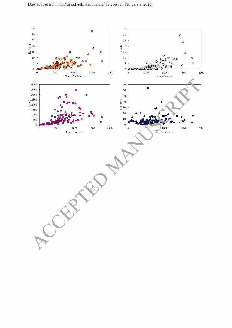
Increased concentrations of porphyry copper pathfinder elements Re, Se, Te and Mo are
observed in saline pockets compared to low-salinity alluvial material (Fig. 6). Distinct
ACCEPTED MANUSCRIPT
by guest on February 9, 2020http://geea.lyellcollection.org/Downloaded from
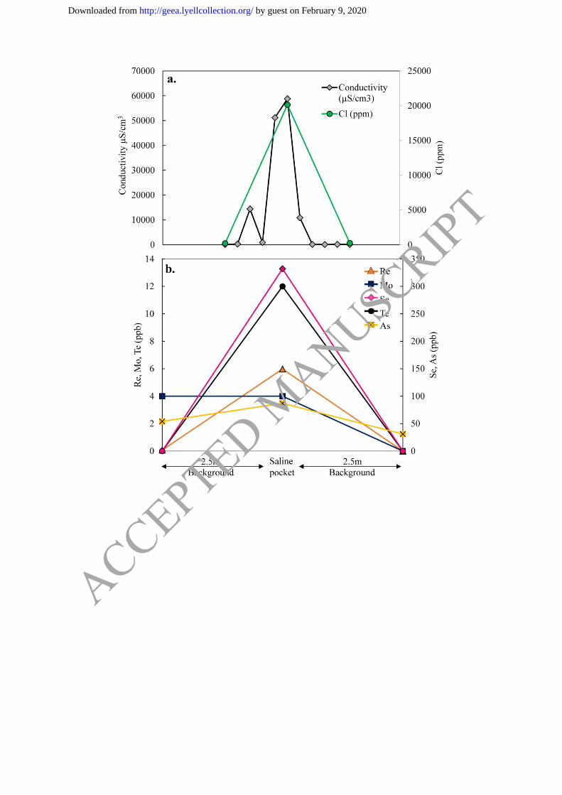
differences in salinity and metal concentration between saline pockets and low-salinity
alluvial material located within 2.5 m of the pockets, were observed (Fig. 7a, b). Comparable
responses were also observed at four additional similar sites sampled throughout the project
area.
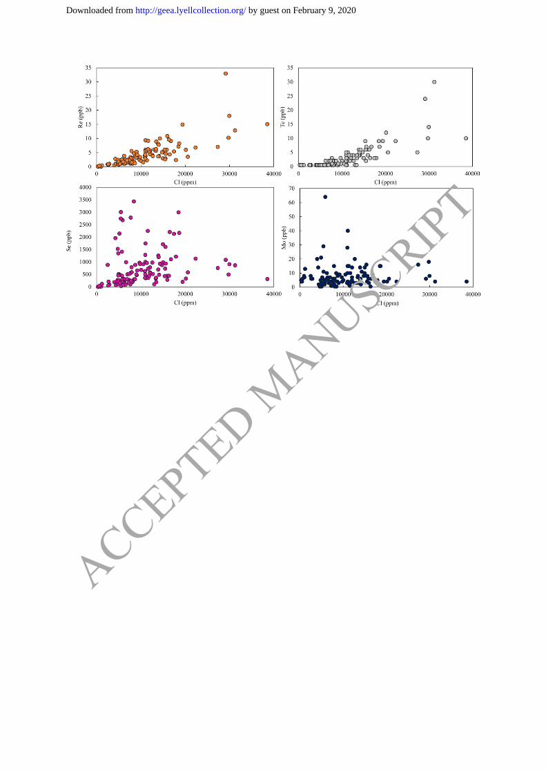
Concentrations of Re, Te, Se and Mo increase with increasing salinity (Fig. 8). Salinity in the
sample is represented as the sum of the molar concentrations of the major cations (Ca2+
,
Mg2+
, Na+, K
+) by deionized water leach because not all anions, such as nitrate and
bicarbonate, were determined in the deionized water leach analysis. Selenium, Re and Te
show strong correlations with Cl, while a weaker correlation exists between Mo and Cl (Fig.
9). Arsenic and Cu concentrations by deionized water leach, are not significantly elevated in
saline pockets compared to background samples.
Given that the samples are considered to comprise the evaporated remains of groundwater
forced to the surface, it is optimal to treat the results of the deionized water leach / ICP-MS
analysis in a similar manner to conventional groundwater analysis. To this extent, trace
element results were normalized to the molar sum of the major cations to take into account
varying concentrations of saline material accumulated within the pockets.
Vertical Soil Profiles
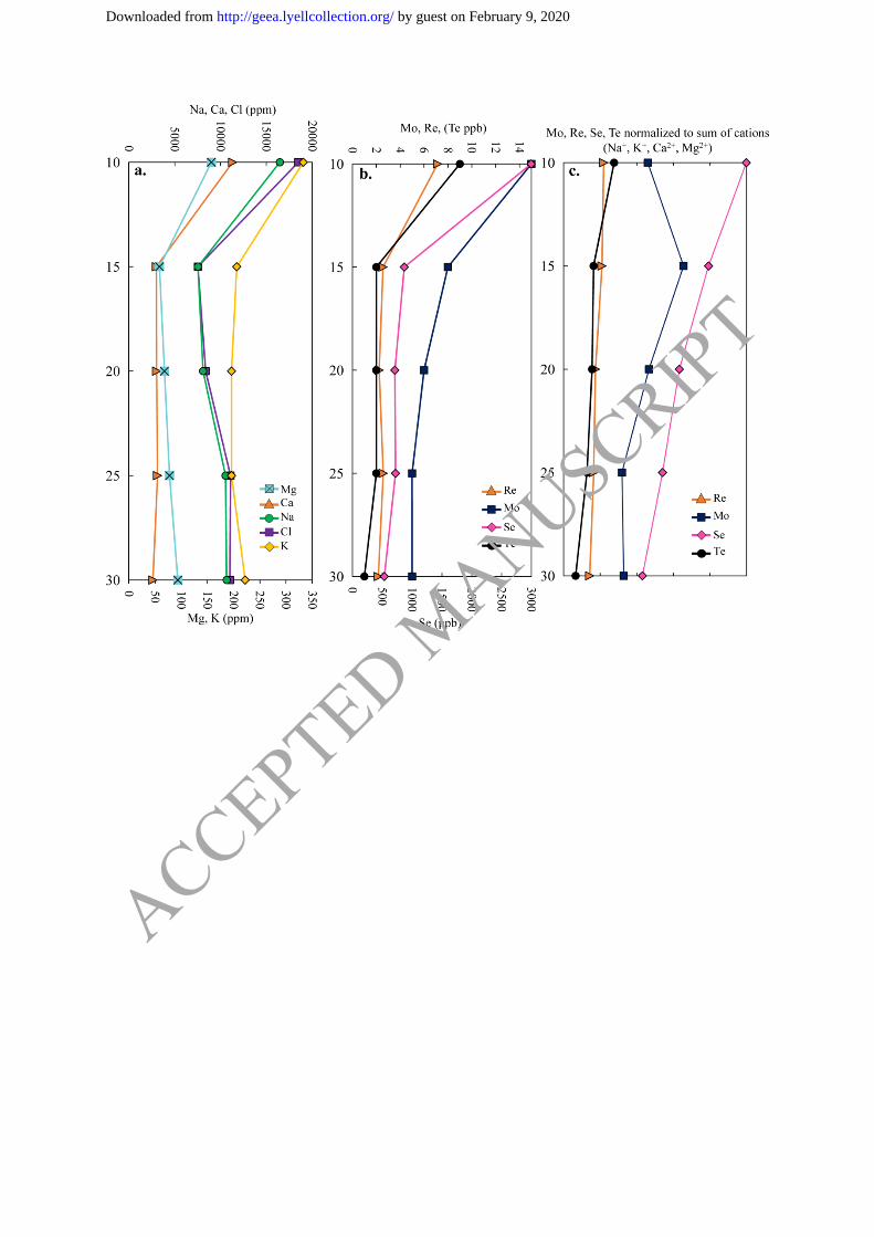
A soil profile of a saline pocket (10 – 30 cm) (Fig. 10) shows a strong correlation of major
cations and Cl with Mo, Re, Te, and Se from 10 to 15 cm. Maximum concentrations of Na
(1.64%) and Cl (1.85%) are measured at a depth of 10 cm, with coincident maximum
concentrations of Se (2996 ppb), Mo (15 ppb), Re (7.14 ppb), and Te (9 ppb). Concentrations
of Na and Cl both decrease to 0.75% (7534 ppm and 7535 ppm, respectively) at 15 cm,
together with decreased concentrations of Se (869 ppb), Mo (8 ppb), Re (2.56 ppb) and Te (2
ppb). Concentrations of Re, Se and Te are consistent from 15 cm to 30 cm, while Na and Cl
increase to 1.0% and 1.1%, respectively. Concentrations of Mo continue to decrease from 15
to 30 cm. Normalizing metal concentration to the molar sum of the major cations (Na, Ca,
Mg, K) through the vertical profile reveals a fairly consistent metal signature from 10 cm to
30 cm, with the exception of Se which decreases down profile.
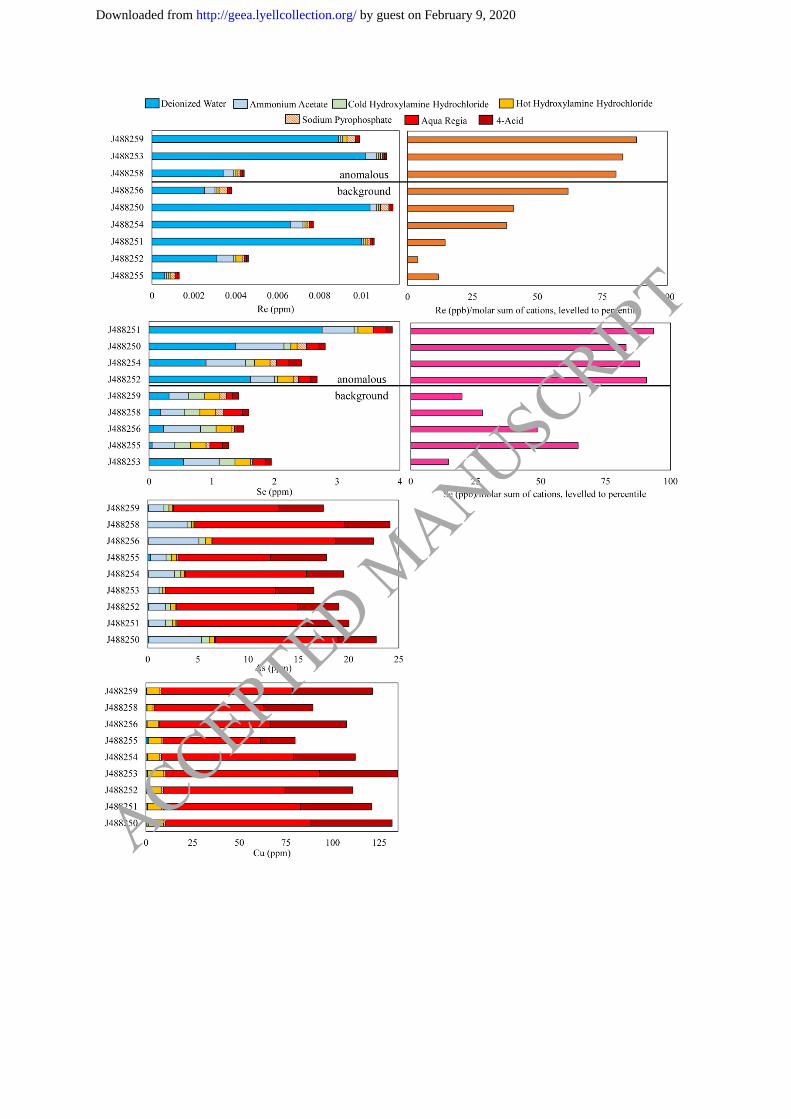
Sequential Leach Analyses
Sequential leach analyses indicate near-total extraction of Re and Se by deionized water leach
(Fig. 11). The labile portion of Mo is extracted by both deionized water (soluble salts) and
sodium pyrophosphate (organic matter), however Mo concentrations decrease with increasing
organic carbon contents. Results for Te indicate samples submitted for sequential leach
analysis contained concentrations at, or close to detection limit for all selective extractions,
and partial and total digests (medianAquaRegia= 0.05 ppm, median4-acid = 0.04 ppm). This
implies Te extracted by deionized water from other highly saline samples (e.g. Fig. 6) likely
reflects an exogenic source. The labile portion of As is dominantly extracted by ammonium
acetate (carbonates), and the most labile portion of Cu extracted by hot hydroxylamine
hydrochloride (amorphous Fe-oxides; Fig. 11).
Discussion
Source of Metals in Saline Pockets
Saline pockets on the surface are interpreted to form as a result of saline groundwater
transported to the surface during seismic pumping (Brown et al. 2019 this issue). An elevated
NaCl and trace element geochemical signature is detected in saline pockets, compared to
surrounding alluvial material, throughout the project area, up to 2 km away from the deposit.
ACCEPTED MANUSCRIPT
by guest on February 9, 2020http://geea.lyellcollection.org/Downloaded from
We propose that as a result of interaction of mineralization with groundwater, trace elements
are leached into the groundwater, and the geochemical signature is subsequently diffused
outwards. The groundwater is transported to the surface along structures during seismic
activity, forming highly localized saline pockets containing elevated concentrations of NaCl
and trace elements in comparison to surrounding alluvial material.
Groundwater sampling was attempted at existing drillholes, but proved to be impractical as a
result of previous drilling activities. This inhibits the direct correlation of geochemical
signatures observed on the surface to groundwater geochemistry at Atlántida. However, we
argue geochemical signatures observed in saline pockets are formed by the injection of
mineralized groundwater to the surface for the following reasons:
1) Saline pockets are enriched with elements characteristic of porphyry copper
mineralization;
2) Increased metal concentrations are restricted to saline pockets which are distributed
along structural trends; and
3) The relationship between increasing salinity and concentrations of Se, Mo, Re, and
Te indicates time-accumulated volumes of groundwater pumped to the surface will yield
higher concentrations of these elements.
Geochemical and isotopic analysis of the groundwater and surface geochemistry at the
Spence deposit clearly demonstrate the link between the geochemistry of sulfides oxidizing in
the presence of groundwater and the formation of surficial geochemical anomalies (Cameron
& Leybourne 2005; Leybourne & Cameron 2008). The surficial geochemical signature on the
alluvial surface at Spence closely resembles that observed from saline pockets at Atlántida.
Mobility of Metals from Groundwater to Surface
Whilst the oxidation of porphyry deposits, particularly those rich in pyrite or chalcopyrite,
will generate acidic conditions (pH <4), groundwater in the Atacama Desert is currently
dominantly alkaline (pH 7-9) (de Caritat et al. 2007). Elements released from the porphyry
that remain soluble and mobile as oxyanions or neutral hydroxides when pH conditions
change from acid to neutral to alkaline, can be transported to the surface. These include
elements identified in saline pockets: Se (HSeO3-, SeO4
2-, SeO3
2-), Mo (HMoO4
-), Re (ReO4
-,
Re(OH)4(aq)), As (H2AsO4-, HAsO4
2-, As(OH)3(aq)), and Te (HTeO3
-, HTeO4
-, TeO3
2-, TeO4
2-),
all mobile in oxidizing alkaline groundwater conditions (Bethke, 1994; Howard, 1977).
However, the mobility of these elements in groundwater is complex and may be hindered by
adsorption to mineral surfaces, changes in pH, or competing ions such as bicarbonate or
sulfate (Stollenwerk 2003). For example, in oxidizing alkaline conditions, Fe-oxyhydroxides
can play a major role in attenuation of mobile As from groundwater (Smedley & Kinniburgh
2002; Nordstrom 2002). However, Leybourne & Cameron (2008) suggest AsV can travel
considerable distances in groundwater at the Spence Deposit due to the redox state of the
groundwater close to the FeII/Fe
III transition, preventing significant attenuation of As by Fe-
oxyhydroxides. In comparison, Re and Mo both display conservative behaviour, with no
significant adsorption onto particles (Colodner et al. 1993), and are therefore considered
mobile in oxidized saline groundwater. Copper, which dissolves in groundwater as Cu2+
is
considered essentially immobile in alkaline conditions and is further depleted due to the
tendency of Cu2+
to adsorb onto Fe-oxyhydroxides and clay surfaces (Dzombak & Morel
1990), or to precipitate as secondary Cu-oxides or Cu-carbonates (Leybourne & Cameron
2008). The changing element mobility in varying Eh/pH environments may be used as
vectors towards buried mineralization. For example, due to the low mobility of Cu in alkaline
ACCEPTED MANUSCRIPT
by guest on February 9, 2020http://geea.lyellcollection.org/Downloaded from
environments, anomalous Cu concentrations on the surface using a weak leach may indicate
proximity to source.
Hydrogeological information concerning the current Eh-pH conditions, or possible mixing of
meteoric and saline groundwater sources at Atlántida is not available. However, groundwater
studies at Inca de Oro, located 25km NNE from Atlántida, report mean pH of 7.42 and Eh
(mV) of 385 – 415, comparable to measurements at Spence (mean pH of 7.32 and Eh (mV)
of -100 – 250) and Mantos Blancos (mean pH of 7.41) (Reich et al. 2008; Leybourne &
Cameron 2008; Soto 2010). This suggests oxidizing and alkaline groundwater conditions in
the Inca de Oro – Atlántida area, allowing for Mo, Re, Se, Te and As to be present as mobile
oxyanions.
Upon reaching the surface and commencement of evaporation under hyper-arid conditions,
elements may be incorporated into secondary mineral phases depending on Eh-pH conditions.
The pH of saline pocket samples is neutral to alkaline, ranging from 7 – 10.5. The near-total
extraction by deionized water leach of Se and Re (Fig. 11) indicate that these elements are
preserved on the surface in the same water-soluble form in which they were transported to the
surface, without significant incorporation into secondary mineral phases.
Organic carbon analyses of saline pocket material indicate extremely low organic carbon
contents (0.2 % – 0.8 %), similar to organic carbon contents measured in the hyper-arid core
of the Atacama Desert (Ziolkowski et al. 2013; Azua-Bustos et al. 2015; Robinson et al.
2015). The low organic content indicates that Mo extracted by the sodium pyrophosphate
leach is likely Mo solubilized from another water insoluble mineral phase, for example
ferrimolybdate (Jones, 1957), besides those extracted earlier in the sequential extraction
sequence (i.e., is not associated with carbonate nor amorphous Fe-Mn-oxides) under the
alkaline nature (pH 10) of the leach. This may contribute to the weaker correlation observed
between Mo and increasing sum of cations and Cl by deionized water leach.
Sequential leach results indicate As, despite being mobile as an oxyanion, is sequestered by
carbonates near the surface (Fig. 11) (Goldberg & Glaubig 1988). Adsorption of As on
secondary mineral phases clarifies why low concentrations of As are extracted from saline
pockets by the deionized water leach. Any labile fraction of Cu, derived from an exogenic
source or released from the weathering of clasts on the surface, is dominantly adsorbed onto
Fe-oxyhydroxides (Fig. 11) as a result of the high affinity for cation adsorption in alkaline
environments (Dzombak & Morel 1990).
Assuming no major redistribution of elements to secondary mineral phases other than As,
analysis by deionized water leach of material from saline pockets allows for the recreation of
the geochemical signature of the groundwater interacting with mineralization. Concentrations
of elements, leached by deionized water, from saline pockets and which have not been
dominantly incorporated into secondary mineral phases (i.e., Se, Mo, Re and Te), can hence
be used to vector towards buried mineralization in the same way groundwater data are used to
vector to mineralization (e.g., Casa Grande porphyry in Arizona, Ficklin et al. 1981; Bathurst
Mining Camp (VMS) in Canada, Leybourne et al. 2003; Spence porphyry deposit in Chile,
Leybourne & Cameron 2008).
Data Processing: Normalization of Metal Signature from Saline Pockets to Groundwater
Volume Proxy
As groundwater interacts with mineralization, releasing porphyry copper pathfinder elements,
the concentration of elements leached from the porphyry into groundwater will increase
proximally, yet the volume of groundwater pumped to the surface during seismic events may
ACCEPTED MANUSCRIPT
by guest on February 9, 2020http://geea.lyellcollection.org/Downloaded from
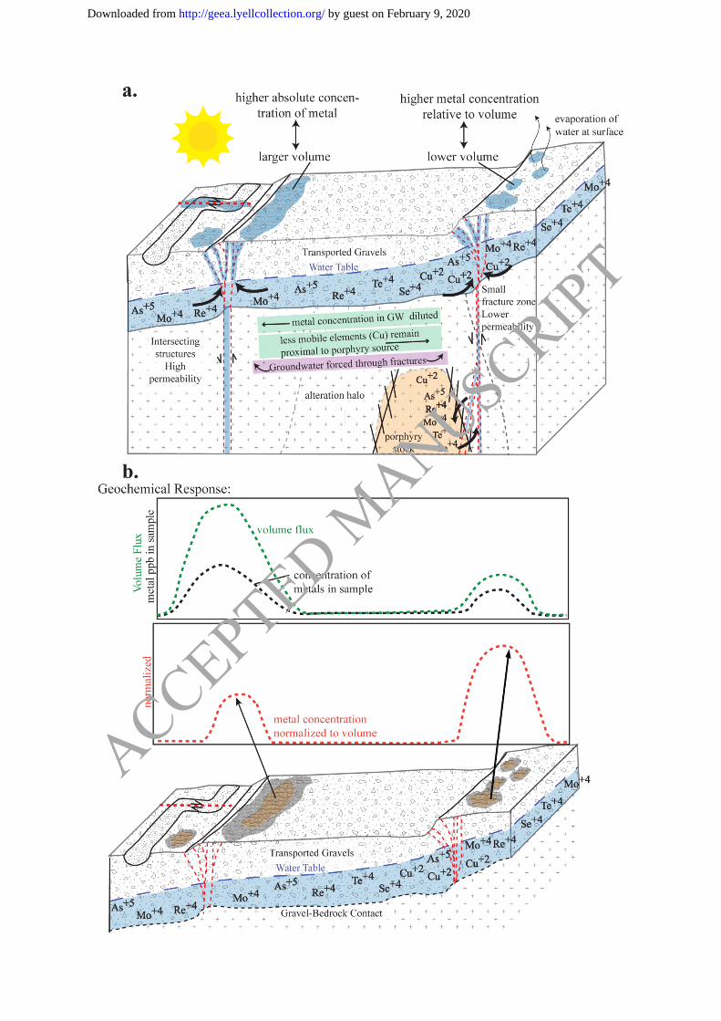
not be equal across all saline pockets (Fig. 12), resulting in concentration variability
reflecting volumes rather than concentrations.
The volume of groundwater which reaches the surface controls the salinity and concentration
of elements at the surface (Figs. 8 & 10), and can be represented as the sum of the major
cations analyzed by deionized water leach. Element concentrations must therefore be
normalized to the varying groundwater volume flux reaching the surface and forming the
pockets. The concentration of each metal (Se, Mo, Re, Te) was normalized to the molar sum
of the major cations at each site separately and expressed as percentiles. The percentiles of
Se, Mo, Re, and Te were summed and re-expressed as a percentile. Summed normalized
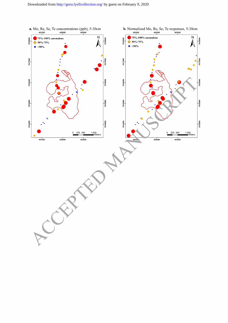
responses of Se, Mo, Re and Te are elevated directly over mineralization (Fig. 13).
Normalizing the response to the sum of molar cations ensures that anomalous concentrations
are not simply a result of a larger groundwater flux, and tightens the geochemical response to
directly over the target (Fig. 13). No information concerning groundwater source, flow
direction, rate of flow and fault controlled changes to groundwater hydrology is available at
Atlántida. This methodology therefore is based on the assumption that groundwater is
homogeneous throughout the Atlántida area.
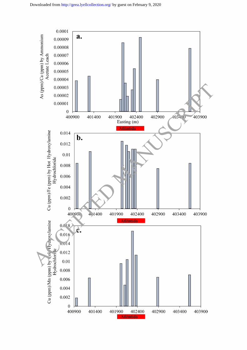
Arsenic and Copper Signatures above Atlántida
Analyses by ICP-MS after ammonium acetate leach of select samples over Atlántida show
slightly elevated responses of As normalized to Ca over mineralization (Fig. 14a). This may
indicate an elevated concentration of As in the groundwater proximal to the deposit, that
upon reaching the surface, is incorporated into carbonates as a result of the highly alkaline
surficial environment. Concentration levels are, however still low, with a poor anomaly to
background contrast.
Analyses of Cu extracted from Fe-oxides in saline pockets using a hot (90°C) hydroxylamine
hydrochloride leach do not show a clear response over mineralization (Fig. 14b). Analysis of
Cu by cold (60°C) hydroxylamine hydrochloride leach, extracted from Mn-oxides and
surfaces of Mn- and Fe-oxides show elevated responses of Cu/Mn over mineralization (Fig.
14c), yet very low concentrations of Cu are extracted using this method (maximum
concentration of 1.3 ppm Cu). These results likely indicate Cu is not present in significant
concentrations in the groundwater, possibly due to its reduced solubility in alkaline
conditions. Saline pockets may therefore not be significantly enriched in Cu compared to
background concentrations, potentially resulting in poor anomaly to background contrast.
Comparison of Surficial Geochemical Results from Other Buried Deposits in Chile
Distribution of elements in vertical soil profiles above the Spence deposit by ICP-MS after
deionized water leach and enzyme leach reveal increasing concentrations with depth (30 cm –
100 cm) of elements which are soluble (NaCl) and those that form oxyanions in aqueous
solution (As, Se) (Cameron & Leybourne 2005). They observed that elements which dissolve
as cations (Cu2+
, Ag2+
, Pb2+
) are concentrated in the upper 30 cm. The interpretation of this
behaviour is the redistribution of elements at the surface by infrequent rains (Cameron &
Leybourne 2005). Sampling depth at Atlántida did not exceed 40 cm, therefore no direct
comparisons to element distribution at the Spence deposit can be made. However, vertical
soil profiles at Atlántida show increased concentrations of soluble elements (Mo, Re, Se, Te,
Na, Cl) from 10 – 15 cm depth, potentially due to evaporation of injected groundwater at the
surface.
Surficial geochemical responses observed throughout northern Chile, including at the Spence
deposit (Cameron & Leybourne 2005), Mantos Blancos (Palacios et al. 2005), Radomiro
ACCEPTED MANUSCRIPT
by guest on February 9, 2020http://geea.lyellcollection.org/Downloaded from
Tomic, Mansa Mina (Cameron et al. 2010), and Gaby Sur (Cameron et al. 2004) are
characterized by highly localized, elevated concentrations of halogens (Cl, Br, I) and Na
occurring with high concentrations of porphyry copper pathfinder elements such as As, Se,
Mo, V and Re. Geochemical responses from the Spence Deposit and Gaby Sur were directly
correlated with fracture zones in the gravels identified afterwards by trenching (Cameron et
al. 2000). Anomalous samples from Mantos Blancos and Mansa Mina were directly
correlated with mapped bedrock faults extending through overlying gravels, including the
West Fissure Fault system at Mansa Mina. Responses from Radomiro Tomic were similarly
highly localized and were interpreted to have formed by unmapped faults in the area
(Palacios et al. 2005; Cameron et al. 2010).
This geochemical response is clearly observed at Atlántida. This suggests geochemical
responses on the surface above buried porphyry deposits are similar throughout the Atacama
Desert as a result of the mobility of porphyry copper pathfinder elements in alkaline
groundwater, and the strong structural control on anomaly formation at the surface.
Elevated Cu concentrations in surface samples are also observed directly over mineralization
at the previously studied deposits (Cameron et al. 2004; Cameron & Leybourne 2005;
Palacios et al. 2005; Cameron et al. 2010). The distribution of Cu on the surface at these
deposits is limited to directly over mineralization as a result of the restricted Cu mobility, due
to the Eh–pH conditions of the groundwater, as demonstrated at the Spence deposit (Cameron
& Leybourne 2005). In contrast, Atlántida does not show highly anomalous concentrations of
Cu on the surface above mineralization. Palacios et al. (2005) suggest Cu responses on the
surface in the Atacama are influenced by the depth of mineralization, leach cap thickness, ore
grade and the thickness of overlying barren rock. The depth of mineralization, low-grade ore
(~0.2% Cu) and alkaline conditions at Atlántida may therefore contribute to the lack of a
strong Cu response observed on the surface.
Mineralization at Atlántida is reported as 100% hypogene, with no evidence for significant
supergene enrichment (Hope & Andersson 2015). Cameron et al. (2010) suggest deposits
having undergone supergene enrichment can later be subjected to additional metasomatism of
Cu-oxides by saline groundwater infiltration, resulting in the precipitation of atacamite
(Cameron & Leybourne 2005; Cameron et al. 2007; Reich et al. 2008; Reich et al. 2009).
Atacamite, a Cu chloride (Cu2Cl(OH)3), is highly soluble in meteoric groundwater (Reich et
al. 2008). For example, atacamite was dissolved from a large section of the central oxide
zone at Radomiro Tomic by infiltration of meteoric groundwater during transport of alluvial
gravels (Cameron et al. 2010). Interaction of meteoric groundwater and atacamite would lead
to increased Cu concentrations in groundwater, compared to water-rock interactions with Cu-
sulfides. Increased concentrations of Cu may then allow for appreciable Cu concentrations to
reach the surface by seismic pumping of groundwater, even from considerable depth. For
example, at Mantos Blancos, where the oxide zone near surface contains atacamite yet the
water table is currently present at 400m depth, groundwater transport along faults has created
salt efflorescence along fault structures at the surface. Salt efflorescence which occur directly
over mineralization can exceed 1000 ppm Cu and have a distinct green colouration resulting
from a mixture of atacamite and chalchanthite (Palacios et al. 2005; Cameron et al. 2010).
Thus, the absence of a Cu-oxide zone or supergene enrichment blanket at Atlántida has likely
also contributed to the weak geochemical response of Cu at the surface. Anomalous
concentrations of Cu extracted on the surface using a weak leach may therefore potentially
provide information regarding depth and type of Cu mineralization (hypogene vs. supergene).
ACCEPTED MANUSCRIPT
by guest on February 9, 2020http://geea.lyellcollection.org/Downloaded from
Exploration Recommendations
This study demonstrates a targeted geochemical sampling strategy may significantly improve
the potential for the discovery of buried deposits in the Atacama Desert. This strategy is
based on evidence from several sites suggesting that groundwater is forced to the surface
during seismic events along permeable fractures, forming discrete saline pockets at the
surface. Sampling saline pockets over the visible extent of structures at the surface,
identifiable using remote sensing and regolith mapping (Brown et al. 2019 this issue), is
necessary.
Regular grid pattern geochemical programs (e.g., 1 sample per 250 m or 500 m), a standard
practice used by industry, rely on chance to sample on structural trends. Grid sampling using
250 partial leach geochemistry in areas dominated by transported cover does not consider
variable background chemistry, metal transport, predictive chemistry or signal preservation.
These are all important components required for effective application of partial leach
geochemistry for the discovery of buried deposits in covered terrains.
Based on work at Atlántida, we recommend the following for designing an effective
geochemical survey for application at a regional, district or target scale:
(1) Use of remote sensing, regolith mapping and geomorphic markers of faulting to map
the physical extent of fault features on the surface. Remote sensing at high-resolution
can also identify distinct saline pockets distributed along structural trends;
(2) Use of total dissolved solids/conductivity for identification of saline pockets in the
field;
(3) Sample grids (e.g. 250 m x 250 m) can be oriented parallel to the orientation of
structural trends, where within a grid cell a saline pocket can be identified and
specifically sampled as the target medium. Sample lines with 25 m to 50 m spacing
(sampling saline pockets) should be oriented perpendicular to structural trend,
extending up to 150 m from the main fault zone;
(4) Sample on relatively older alluvial surfaces to allow for signal accumulation, avoiding
young channels or recently deposited material on older surfaces;
(5) Use a weak digestion (e.g., deionized water leach) to extract labile, exogenic
signatures;
(6) Consider element mobility and predictive chemistry of porphyry weathering by rock-
groundwater interaction. These elements will include Mo, As, Se, Te and Re, soluble
as oxyanion/neutral hydroxide complexes in alkaline conditions, in contrast to the low
mobility of Cu in alkaline conditions. And;
(7) Data interpretation requires normalization of metal concentration to total major
cations as a proxy for groundwater volume.
Notably, normalization of samples taken outside saline pockets and which, hence, are not
representative of the surface effusion of groundwater, including low-salinity background
samples should be avoided as it will result in over-representation of metal concentrations in
those samples. In areas dominated by evaporitic soils (caliche/gypsum), background salinity
of the evaporitic surface can be high and therefore careful identification of saline pockets and
establishment of background salinity is required for proper sampling.
ACCEPTED MANUSCRIPT
by guest on February 9, 2020http://geea.lyellcollection.org/Downloaded from
Conclusions
The localized nature of geochemical responses on the surface observed at Atlántida
emphasizes the importance for targeted sampling of saline pockets along structural trends.
Geochemical results and geomorphic observations indicate the rate of erosion is low enough
in the Atacama Desert (e.g. Carritier et al. 2018) to preserve the surficial anomalies formed as
saline pockets by mineralized groundwater forced to the surface during seismic activity.
Geochemical signatures of Se, Mo, Re and Te, normalized to a proxy for groundwater
volume, show elevated responses directly over mineralization, indicating targeted sampling
of saline pockets along structures can be used to vector towards buried mineralization. The
magnitude of anomalous Cu responses on the surface may provide information concerning
the depth of mineralization, or perhaps the type (hypogene vs. supergene) of Cu
mineralization below. In order to be effective, targeted sampling must employ an
understanding of element transport, predictive chemistry of porphyry copper pathfinder
elements in changing Eh/pH environments, and signal preservation on the surface. Sampling
of saline pockets along structural trends identified using remote sensing and deionized water
extraction geochemistry, provides a unique opportunity to sample the geochemistry of the
groundwater, potentially interacting with buried mineralization, by only sampling on the
surface. Saline pockets have been identified at four other sites throughout the Atacama Desert
extending as far north as Chuquicamata (Brown et al. 2019 this issue), demonstrating that this
type of targeted sampling has the potential to be widely applicable in the Atacama Desert of
Chile, and potentially other desert environments in active tectonic terrains, for the discovery
of buried porphyry deposits.
Acknowledgements
We thank the sponsor companies, First Quantum Minerals Ltd., Quantum Pacific
Exploration, and AngloAmerican Ltda. for project support and logistical support in the field.
In particular, Steve Andersson, McLean Trott, and Esteban Urqueta are thanked for their
discussions and insights throughout the project. We thank Minera Atlántida for access to the
Atlántida field site. The Society of Economic Geology (SEG) is thanked for a generous
scholarship to the principal author. We are grateful to Robert Garrett and Stephen Amor for
their constructive reviews. This is MDRU Publication 419.
Funding
This project was financially supported by AngloAmerican Ltda., First Quantum Minerals Ltd,
and Quantum Pacific Exploration through the MDRU Atacama Gravels Project and an SEGF
student research grant (to AB).
ACCEPTED MANUSCRIPT
by guest on February 9, 2020http://geea.lyellcollection.org/Downloaded from
References
Azua-Bustos, A., Caro-Lara, L., & Vicuña, R. (2015). Discovery and microbial content of the
driest site of the hyperarid Atacama Desert, Chile. Environmental Microbiology
Reports, 7(3), 388-394. https://doi.org/10.1111/1758-2229.12261
Bethke, C.M. (1994). The Geochemist’s Workbench. University of Illinois.
Bissig, T., & Riquelme, R. (2010). Andean uplift and climate evolution in the southern
Atacama Desert deduced from geomorphology and supergene alunite-group minerals.
Earth and Planetary Science Letters, 299(3-4), 447-457.
https://doi.org/10.1016/j.epsl.2010.09.028
Brown, A. (2018). Geochemical Sampling Strategies for Discovery Buried Copper
Porphyries, Atacama Desert, Chile. Unpublished Master's Thesis. University of
British Columbia. 262 p.
Brown, A., Winterburn, P., Bissig, T. (2019) Identification of the expression of earthquake-
induced surface flooding by groundwater using detailed regolith mapping at the
buried Atlantida Deposit, northern Chile. Geochemistry: Exploration, Environment,
Analysis.
Cameron, E. M., Hamilton , S. M., Leybourne, M. I., Hall, G. E., & McClenaghan , B. M.
(2004). Finding deeply buried deposits using geochemistry. Geochemistry:
Exploration, Environment, Analysis, 4(1), 7-32. https://doi.org/10.1144/1467-
7873/03-019
Cameron, E. M., & Leybourne, M. I. (2005). Relationship between groundwater chemistry
and soil geochemical anomalies at the Spence copper porphyry deposit, Chile.
Geochemistry: Exploration, Environment, Analysis, 5(2), 135-145.
https://doi.org/10.1144/1467-7873/03-064
Cameron, E. M., Leybourne, M. I., & Kelley, D. L. (2002). Exploring for deeply covered
mineral deposits: Formation of geochemical anomalies in northern Chile by
earthquake-induced surface flooding of mineralized groundwater. Geological Society
of America, 30(11), 1007-1010. https://doi.org/10.1144/1467-7873/09-228
Cameron, E. M., Leybourne, M. I., Reich, M., & Palacios, C. (2010). Geochemical anomalies
in northern Chile as a surface expression of the extended supergene metallogenesis of
buried copper deposits. Geochemistry: Exploration, Environment, Analysis, 10(2),
157-169. https://doi.org/10.1144/1467-7873/09-228
Cameron, E., Leybourne, M., & Palacios, C. (2007). Atacamite in the oxide zone of copper
deposits in northern Chile: Involvement of deep formation waters. Mineralium
Deposita, 42(3), 205-218. https://doi.org/10.1007/s00126-006-0108-0
Cameron, E., Leybourne, M., Venegas, R., & Vasquez, A. (2000). Preliminary Report:
Geochemical data for soils over the Gaby Sur Deposit, Chile.
Carretier, S., Tolorza, V., Regard, V., Aguilar, G., Bermudez, M., Martinod, J., Guoyt, J-L.,
Hérail, G., Riquelme, R. (2018). Review of erosion dynamics along the major N-S
climatic gradient in Chile and perspectives. Geomorphology, 300(1), 45-68.
https://doi.org/10.1016/j.geomorph.2017.10.016
ACCEPTED MANUSCRIPT
by guest on February 9, 2020http://geea.lyellcollection.org/Downloaded from
Colodner, D., Sachs, J., Ravizza, G., Turekian, K., Edmond, J., & Boyle, E. (1993). The
geochemical cycle of rhenium: a reconnaissance. Earth and Planetary Science
Letters, 117(1-2), 205-221. https://doi.org/10.1016/0012-821X(93)90127-U
de Caritat, P., McPhail, D., Kyser, K., Oates, C., Polito, P., & Winterburn, P. (2007). Using
groundwater chemical and isotopic composition in the search for porphyry copper and
base metal deposits: Examples from Chile and India. Abstracts. 23rd International
Geochemical Exploration Symposium, Oviedo, Spain, June 2007.
Dzombak, D., & Morel, F. (1990). Hydrous Ferric Oxide: Surface complex modeling. New
York: Wiley, 416 p.
Ficklin, W., Preston, D., Welsch, E., & Nowlan, G. (1981). Analytical results for seventy
eight ground-water samples from the Casa Grande vicinity, Arizona. Vol. U.S.
Geological Survey Open File Report 81-960 (ed. USGS).
https://doi.org/10.3133/ofr81960
Goldberg, S., & Glaubig, R. (1988). Anion sorption on a calcareous, montmorillonitic soil.
Soil Science Society of America Journal, 52(5), 1297-1300.
Hope, M., & Andersson, S. (2015). Geophysical Response of the Atlántida Cu-Au Porphyry
Deposit, Chile - An Undercover Discovery in an Old District. 24th International
Geophysical Conference and Exhibition, (p. 7). Perth, Western Australia.
Howard, J.H. (1977). Geochemistry of selenium: formation of ferrosilite and selenium
behaviour in the vicinity of oxidizing sulfide and uranium deposits. Geochimica et
Cosmochimica Acta, 41(11), 1665-1678. https://doi.org/10.1016/0016-
7037(77)90176-4
Jones, L.H.P. (1957). The solubility of molybdenum in simplified systems and aqueous soil
suspensions. Journal of Soil Science, 8(2), 313-327.
Kelley, D. L., Benn, C., Riedell, K. B., & Johnson, T. (2010). The Role of Geochemistry in
Andean Copper Discoveries. Society of Economic Geologists Special Publication 15,
271-286. https://doi.org/10.5382/SP.15.1.15
Leybourne, M. I., & Cameron, E. M. (2008). Source, transport and fate of rhenium, selenium,
molybdenum, arsenic, and copper in groundwater associated with porphyry-Cu
deposits, Atacama Desert, Chile. Chemical Geology, 247(1-2), 208-228.
https://doi.org/10.1016/j.chemgeo.2007.10.017
Leybourne, M., Boyle, D., & Goodfellow, W. (2003). Interpretation of stream water and
sediment geochemistry in the Bathurst Mining Camp, New Brunswick: Applications
to mineral exploration. In W. Goodfellow, S. McCutcheon, & J. Peter (Eds.), Massive
Sulphide Deposits of the Bathurst Mining Camp, New Brunswick, and Northern
Maine, Economic Geology Monograph, 11 (pp. 741-762).
Maksaev, V., Almonacid, T., Minuzaga, F., Valencia, V., McWilliams, M., & Barra, F.
(2010). Geochronological and thermochronological constraints on porphyry copper
mineralization in the Domeyko alteration zone, northern Chile. Andean Geology,
37(1), 144-176. http://dx.doi.org/10.4067/S0718-71062010000100007
Matthews, S., Cornejo, P., & Riquelme, R. (2006). Carta Inca de Oro, Region de Atacama.
Servicio Nacional de Geologia y Mineria. Carta Geologica de Chile, Serie Geologia
Basica, No. 102, 79 p. 1 mapa escala 1:100,000. Santiago.
ACCEPTED MANUSCRIPT
by guest on February 9, 2020http://geea.lyellcollection.org/Downloaded from
Nordstrom, D. (2002). Worldwide occurrences of arsenic in groundwater. Science,
296(5576), 2143-2145. 10.1126/science.1072375
Palacios, C., Guerra, N., Townley, B., Lahsen, A., & Parada, M. (2005). Copper
geochemistry in salt from evaporite soils, Coastal Range of the Atacama Desert,
northern Chile: an exploration tool for blind Cu deposits. Geochemistry: Exploration,
Environment, Analysis, 5(4), 371-378. https://doi.org/10.1144/1467-7873/05-075
Pizarro, P. I. (2016). Gas transported elements as an exploration technique under post-mineral
cover: Atlantida deposit and surroundings. Unpublished Master's Thesis. Universidad
de Chile. 116 p.
Reddy, M., Plummer, N., & Busenberg, E. (1981). Crystal growth of calcite from calcium
bicarbonate solutions at constant PCO2 and 25°C: a test of a calcite dissolution model.
Geochemica and Cosmochemica Acta, 45(8), 1281-1289.
https://doi.org/10.1016/0016-7037(81)90222-2
Reich, M., Palacios, C., Parada, M., Fehn, U., Cameron, E., Leybourne, M., & Zuniga, A.
(2008). Atacamite formation by deep saline waters in copper deposits from the
Atacama Desert, Chile: evidence from fluid inclusions, groundwater geochemistry,
TEM and 36
Cl data. Miner Deposita, 43(6), 663-675.
Reich, M., Palacios, C., Vargas, G., Luo, S., Cameron, E., Leybourne, M., Parada, M.,
Alejandro Z., & You, C-F. (2009). Supergene enrichment of copper deposits since the
onset of modern hyperaridity in the Atacama Desert, Chile. Mineralium Deposita,
44(5), 479-504. https://doi.org/10.1007/s00126-009-0229-3
Robinson, C., Wierzchos, J., Black, C., Crits-Christoph, A., Ma, B., & Ravel, J., Ascaso, C.,
Artieda, O., Valea, S., Roldán, M., Gómez-Silva, B., & DiRuggiero, J. (2015).
Microbial diversity and the presence of algae in halite endolithic communities are
correlated to atmospheric moisture in the hyper-arid zone of the Atacama Desert.
Environmental Microbiology, 17(2), 299-315. https://doi.org/10.1111/1462-
2920.12364
Sillitoe, R. H. (2010). Porphyry Copper Systems. Economic Geology, 105(1), 3-41.
https://doi.org/10.2113/gsecongeo.105.1.3
Smedley, P., & Kinniburgh, D. (2002). A review of the source, behaviour and distribution of
arsenic in natural waters. Applied Geochemistry, 17(5), 517-568.
https://doi.org/10.1016/S0883-2927(02)00018-5
Soto, M. C. (2010). Hidrogeología e hydrogeoquímica de aguas subterráneas en el distrito
Inca de Oro, Región de Atacama: Procesos de interacción agua-roca y dispersión
geoquímica. Unpublished Master's Thesis. Universidad de Chile. 209 p.
Stollenwerk, K. (2003). Geochemical Processes Controlling Transport of Arsenic in
Groundwater: A Review of Adsorption. In A. S. Welch, Arsenic in Groundwater:
Geochemistry and Occurrence. Boston, MA: Springer, 67-100.
Townley, B., Luca, R., Soto, C., Lopez, L., Puig, A., Anand, R., & Lintern, M. (2015).
Hydromorphic dispersion of metals and geochemical signatures through transported
overburden at the Inca de Oro porphyry copper district, Northern Chile. Congreso
Geológico Chileno, La Serena, Octobre.
ACCEPTED MANUSCRIPT
by guest on February 9, 2020http://geea.lyellcollection.org/Downloaded from
Ziolkowski, L., Wierzchos, J., Davila, A., & Slater, G. (2013). Radiocarbon evidence of
active endolithic microbial communities in the hyperarid core of the Atacama Desert.
Astrobiology, 13(7), 607-616. https://doi.org/10.1089/ast.2012.0854
ACCEPTED MANUSCRIPT
by guest on February 9, 2020http://geea.lyellcollection.org/Downloaded from
Figure Captions
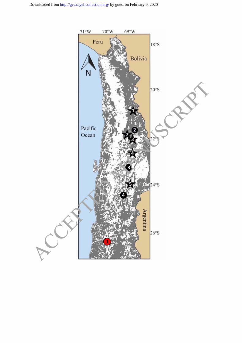
Fig. 1. Map of northern Chile showing large areas of the country covered by gravels. Outcrop
in grey, and alluvial/colluvial cover in white. Red circle indicates study area: 1 – Atlántida.
Black circles indicate additional sites where saline pockets have been identified: 2 – Papas, 3
– Mastodonte and 4 – Viento. Black stars represent several of the major porphyry copper
clusters: 1 – Collahuasi, 2 – Chuquicamata, 3 – Spence, 4 – Gaby Sur, and 5 – Escondida.
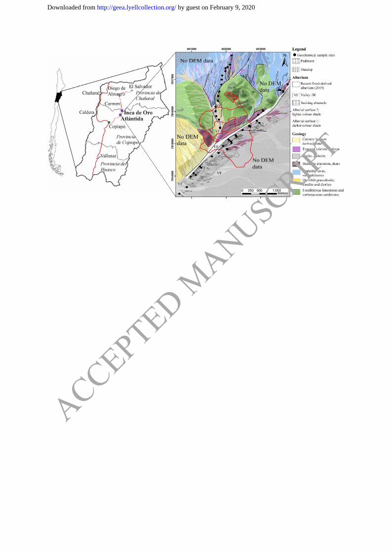
Fig. 2. Location of the buried Atlántida deposit, located 25 km from the Inca de Oro mine.
Solid line represents major highway. Map modified from Townley et al. (2015). Deposit
scale regolith map with DEM (z=5) underlain, shows grade shell outline (> 0.1% Cu, > 0.1g/t
Au) provided by First Quantum Minerals Ltd., projected to surface (solid red line), simplified
structures (black dashed lines) mapped in overlying alluvial cover by using geomorphic
markers of faulting, and geochemical sample locations oriented along NE-SW and N-S
structural trends. Detailed regolith map legend in Brown, 2018. Coordinates given in UTM
zone 19S datum WGS84.
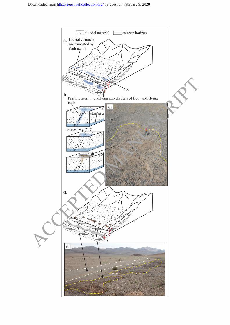
Fig. 3. Schematic diagram of the response of alluvial fans to fault movement and the
proposed formation of saline pockets by effusion of groundwater to the surface during
earthquake-induced seismic pumping. (a) Deep-seated bedrock faults extending from depth
to surface create a fracture zone of high permeability in overlying alluvial fans. Fault action
affects the geomorphology of the alluvial fans, exposing the calcrete horizon. Groundwater
may pool on the surface as a result of seismic pumping. (b) Detailed view of the formation of
a saline pocket and (c) field photograph of saline pocket surface (outlined in yellow dashed
line, and shovel for scale). (d) Saline pockets form along the trace of faults at the surface
where groundwater has pooled as a result of seismic activity. Pockets are not preserved in
erosional channels. (e) Field photograph of saline pocket surfaces (outlined by yellow dashed
lines) along the side of an alluvial fan affected by faulting. Saline pockets are not preserved
in the erosional channel (outlined by white dashed lines).
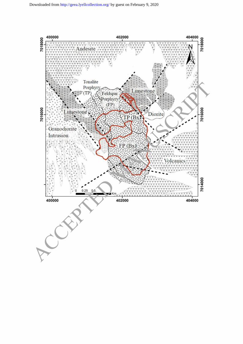
Fig. 4. Simplified geological map showing surficial geology (outcrop and pediment, white =
alluvial cover) and intrusions (TP, TP(Bx), FP, FP(Bx)) mapped below the cover by First
Quantum Minerals Ltd. Structures identified by aeromagnetics are simplified and shown by
black dashed lines. Grade shell outline (> 0.1% Cu, > 0.1g/t Au) projected to surface shown
by solid red line.
Fig. 5. a) Na (ppm) vs. Cl (ppm) after deionized water leach show elevated concentrations of
NaCl in saline pockets vs. surrounding background alluvial material. b) Box-plot showing
elevated Br concentrations in saline pockets compared to background alluvial samples.
Fig. 6. Box plots of analyses of Cl, Re, Se, Te after deionized water leach of saline pockets
(grey) and background alluvial material (black). Open circles represent outlier data and open
triangles represent far outlier data.
Fig. 7. a) Surficial conductivity measured at 0.5 m spacing over 5 m interval across one
saline pocket located at the southern end of the N-S trending sample line and analyses of Cl
after deionized water leach. b) Concentrations of Te, Re, Mo and As from the saline pocket
and two background alluvial samples located 2.5 m on either side of the saline pocket after
deionized water leach.
Fig. 8. Plots of analyses of Re, Se, Te and Mo vs. the molar sum of cations Na+, K
+, Mg
2+,
Ca2+
after deionized water leach.
Fig. 9. Plots of analyses of Re, Se, Te and Mo vs. Cl after deionized water leach.
ACCEPTED MANUSCRIPT
by guest on February 9, 2020http://geea.lyellcollection.org/Downloaded from
Fig. 10. Vertical soil profiles of a saline pocket (10 – 30 cm). (a) Na, Mg, Ca, K and Cl
(ppm) after deionized water leach. (b) Mo, Re, Se, Te (ppb) after deionized water leach. (c)
Mo, Re, Se, Te, normalized to the molar sum of cations.
Fig. 11. Left: Sequential leach results from nine saline pocket samples. Right: Se and Re total
concentrations by deionized water leach extraction normalized to total cations and expressed
as percentiles.
Fig. 12. Conceptual models for (a) transport of trace elements to the surface and varying
volumes of groundwater flux to the surface; and (b) the requirement for normalization of
metal signature to a proxy for groundwater flux. Major cations and anions in groundwater:
Cl-, NO3
-, SO4
2-, CO3
2-, Ca
2+, Mg
2+, K
+, Na
+, H
+, OH
-, H3O
+ omitted for simplicity of
illustration. Metals are soluble as neutral hydroxides, or oxyanions at neutral to alkaline pH.
Fig. 13. (a) Multi-element response of Mo, Re, Se and Te concentrations. (b) Normalized
Mo, Re, Se and Te shown as percentile intervals (<50%, 50% – 75%, 75 – 100%) over
mineralization. Field reproducibility was found to be ~25%, therefore percentile interval 75-
100% is considered anomalous. The grade shell outline (> 0.1% Cu, > 0.1g/t Au) provided by
First Quantum Minerals Ltd., is projected to surface Coordinates given in UTM zone 19.
Fig. 14. Samples taken across SW-NE-trending sample line. (a): As (ppm) normalized to Ca
(ppm) by sequential leach up to and including ammonium acetate leach. (b): Cu (ppm)
normalized to Fe (ppm) by sequential leach up to and including hot hydroxylamine leach. (c):
Cu (ppm) normalized to Mn (ppm) by sequential leach up to and including cold
hydroxylamine hydrochloride leach.
ACCEPTED MANUSCRIPT
by guest on February 9, 2020http://geea.lyellcollection.org/Downloaded from
ACCEPTED MANUSCRIPT
by guest on February 9, 2020http://geea.lyellcollection.org/Downloaded from
ACCEPTED MANUSCRIPT
by guest on February 9, 2020http://geea.lyellcollection.org/Downloaded from
ACCEPTED MANUSCRIPT
by guest on February 9, 2020http://geea.lyellcollection.org/Downloaded from
ACCEPTED MANUSCRIPT
by guest on February 9, 2020http://geea.lyellcollection.org/Downloaded from
ACCEPTED MANUSCRIPT
by guest on February 9, 2020http://geea.lyellcollection.org/Downloaded from
ACCEPTED MANUSCRIPT
by guest on February 9, 2020http://geea.lyellcollection.org/Downloaded from
ACCEPTED MANUSCRIPT
by guest on February 9, 2020http://geea.lyellcollection.org/Downloaded from
ACCEPTED MANUSCRIPT
by guest on February 9, 2020http://geea.lyellcollection.org/Downloaded from
ACCEPTED MANUSCRIPT
by guest on February 9, 2020http://geea.lyellcollection.org/Downloaded from
ACCEPTED MANUSCRIPT
by guest on February 9, 2020http://geea.lyellcollection.org/Downloaded from
ACCEPTED MANUSCRIPT
by guest on February 9, 2020http://geea.lyellcollection.org/Downloaded from
ACCEPTED MANUSCRIPT
by guest on February 9, 2020http://geea.lyellcollection.org/Downloaded from
ACCEPTED MANUSCRIPT
by guest on February 9, 2020http://geea.lyellcollection.org/Downloaded from
ACCEPTED MANUSCRIPT
by guest on February 9, 2020http://geea.lyellcollection.org/Downloaded from