geoeye - un-spider
TRANSCRIPT
1
GeoEyeSee our World…Better than Ever

2
GeoEyeHigh Resolution Satellite Imagery for
Africa
Ms. Andrea Cook
UN SPIDER Regional Conference
9 July 2010

3
What We Do
Our mission is to enable Timely, Accurate and Accessible Location Based Products and Information
4
International
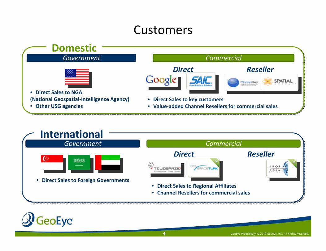
Customers
CommercialGovernment
• Direct Sales to NGA (National Geospatial‐Intelligence Agency) • Other USG agencies
• Direct Sales to key customers• Value‐added Channel Resellers for commercial sales
• Direct Sales to Foreign Governments• Direct Sales to Regional Affiliates• Channel Resellers for commercial sales
Reseller
Commercial
Direct
ResellerDirect
Government Commercial
DomesticGovernment Commercial

5
OrbView-2
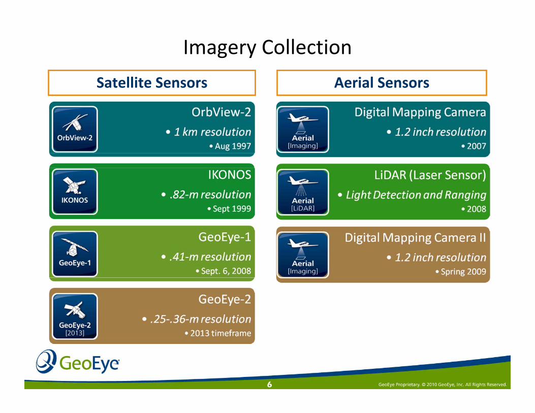
GeoEye Sensors
GeoEye-1 IKONOS
MJ Harden Digital Mapping Camera & LiDAR sensors
GeoEye-2
6
Aerial SensorsSatellite Sensors
Imagery Collection

7
Imagery Collection & SalesHow do we sell imagery?
• Access minutes (time) to our high resolution electro‐optical satellites– IKONOS and GeoEye‐1
– Government Affiliates
• Square kilometers (data) from our satellites– Rights to resell GeoEye‐1 data
collected anywhere
– Both newly collected and archive
– Both Government and Commercial Customers

8
Capabilities• <0.8‐meter resolution• Agility; point and shoot• Increased imaging volumes• Direct regional tasking and imagery downlink
More than 10 years of on‐orbit operational excellence
IKONOS: Built by Lockheed MartinWorld’s First Commercial Sub‐Meter Resolution Satellite

9
GeoEye‐1 Half Meter Imagery
Inchon Airport Korea – Collected Oct 2008

10
GeoEyeGeoEye‐‐1 Key Features1 Key FeaturesHighest resolution, most accurate commercial sensor Highest resolution, most accurate commercial sensor
Resolution.41-meter at nadir.50-meter at 26°1.0-meter at 50°
AccuracyPerformance to date: 3.5m CE90Commercial spec: 5m CE90
Revisit3 days, up to 30° off-nadirDaily, up to 60° off-nadir
Direct downlink and Tasking in Theater

11
GeoEye‐1 is the World’s Most Accurate Commercial Imaging Satellite
Greensburg, Kansas – post tornadoMJ Harden
GeoEye collection assets shown at actual accuracy, others at specified; representation of accuracy on imagery
Satellite Accuracy
GeoEye‐1
<3.5 meter actual <5.5 meters (spec)
WorldView‐1 6.5 Meters (spec)
WorldView‐2 6.5 Meters (spec)
IKONOS 7.8 meters (actual) 15m (spec)
Quickbird 23 meters (spec)
GeoEye’s satellite imagery has twice the accuracy of its nearest competitorGeoEye’s satellite imagery has twice the accuracy of its nearest competitor

12
Faster Response Times
Faster Project Completions
More Opportunities Served
Collection Capacity
• GeoEye Constellation Collection Capacity– GeoEye‐1
• Image 350,000 km2/day in multi‐spectral mode
• 700,000 sq km/day panchromatic mode– IKONOS
• 150,000 sq km/day
• True Constellation Operations for GeoEye‐1 and IKONOS – Phased orbit– Access to all locations nearly every day
White = GeoEye‐1 Collection path
Orange = IKONOS collection path
White = GeoEye‐1 Collection path
Orange = IKONOS collection path

13
Archive imagery is especially valuable for Before and After analysis to detect change
Color Satellite Imagery Archive
GeoEye‐1 and IKONOS archive contains over 420 million sq km of color imagery as of Spring 2010
GeoEye‐1IKONOS

14GeoEye-2GeoEye Selects Lockheed Martin to Begin Engineering and Manufacturing of GeoEye‐2, the Company's Next Commercial Earth‐Imaging Satellite
GeoEye Selects Lockheed Martin to Begin Engineering and Manufacturing of GeoEye‐2, the Company's Next Commercial Earth‐Imaging Satellite

15
Continuity of Imagery
IKONOS0.82m resolution
GeoEye-10.41m resolution
‘17‘16‘15‘14‘13‘12‘11‘07‘99 ‘00 ’01 ‘02 ‘03 ‘04 ‘05 ‘08‘06 ‘09 ‘10
7 Year Design Life(Expected Life: 12)
TodayToday
Assured access to uninterrupted High‐resolution imagery
7 Year Design Life(Expected Life: 10)
GeoEye-2.25m-.36m resolution
7 Year Design Life(Expected Life: 10)

16
Commercial Imagery Products

17
www.geoeye.com

18
GeoFuse: New Online Search Tool
www.geoeye.comwww.geoeye.com

19
Pick your location ‐ Greater Accra area

20
Search for available archive

21
Show footprints of imagery (1/16 resolution)
22
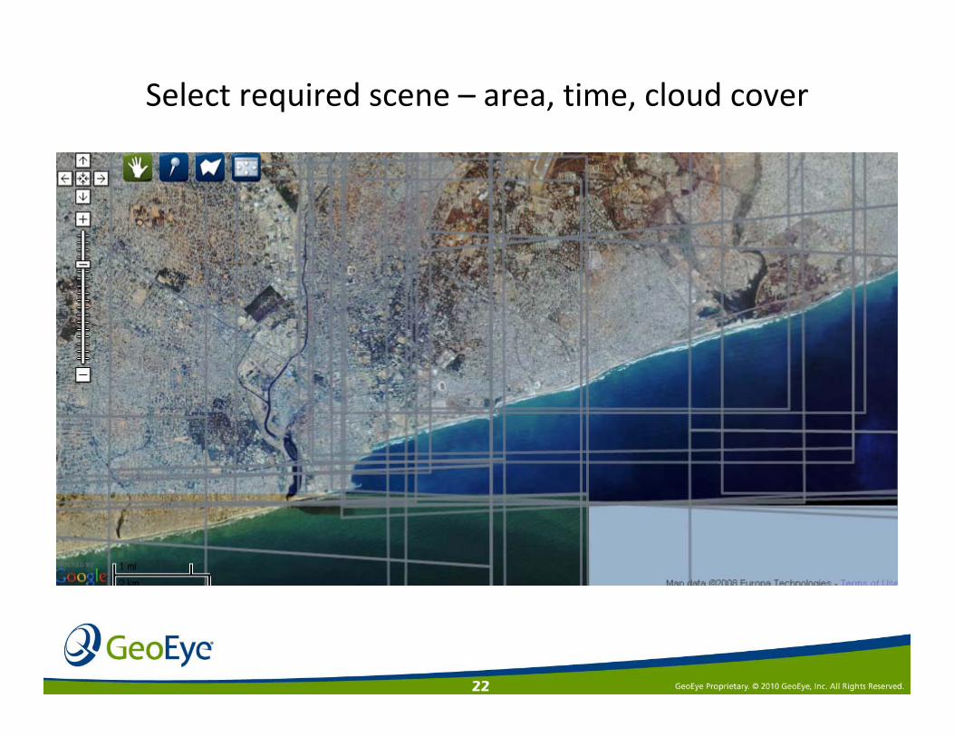
Select required scene – area, time, cloud cover

23
Full resolution 1 meter imagery

24
Zoom into your Area of Interest

25
Imagery Collection Imagery Collection for Disaster for Disaster ResponseResponse

26
GeoEye‐1 Collection PlanPort Au Prince, Haiti

27
Front fold of the Washington Post
January 15, 2010
Front fold of the Washington Post
January 15, 2010

28
The New York TimeJanuary 14, 2010
GeoEye imagery of Port Au Prince, before and after the 7.0 earthquake
disaster
GeoEye imagery of Port Au Prince, before and after the 7.0 earthquake
disaster

29
The Wall Street JournalJanuary 15, 2010
Examining the damage by using GeoEye imagery
Examining the damage by using GeoEye imagery

30GeoEye Proprietary
After the Jan. 12th
earthquake, the Port Au Prince National
Cathedralstill remains standing but terribly damaged
Before AfterBefore After
January 14, 2010January 14, 2010January 14, 2010

31GeoEye Proprietary
Before AfterBefore After
The front of the Presidential
Palace crumbled to the ground
January 14, 2010January 14, 2010January 14, 2010
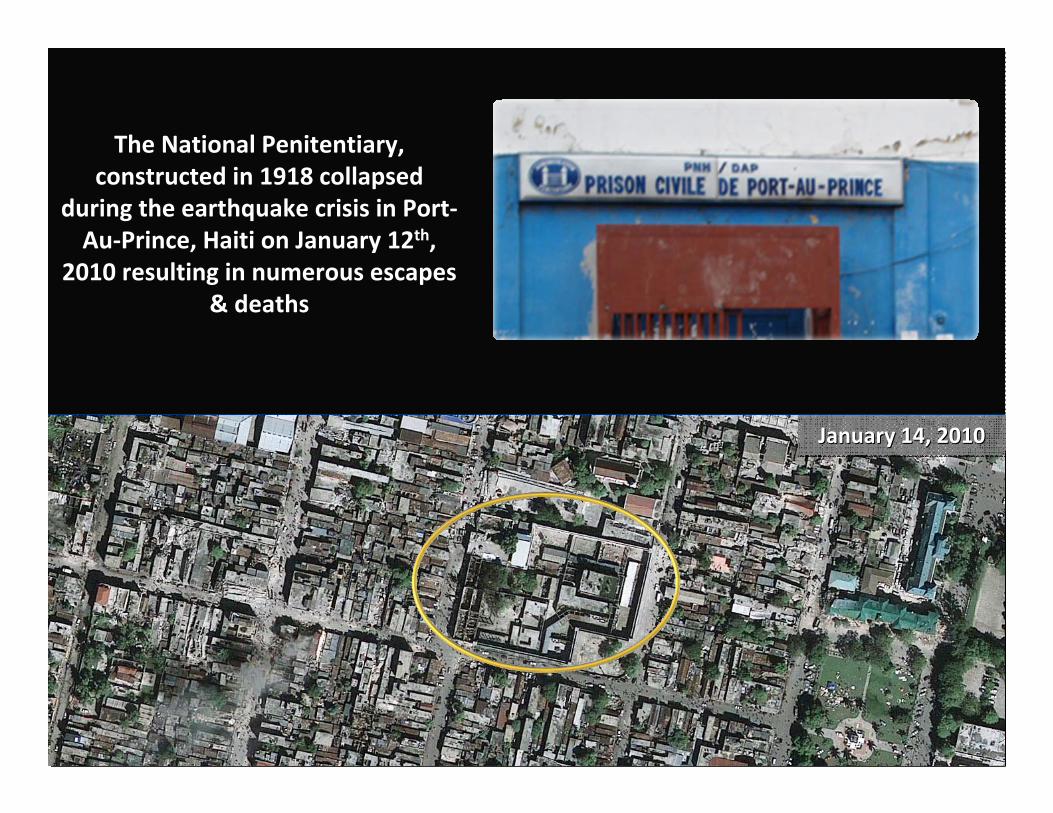
32GeoEye Proprietary
The National Penitentiary, constructed in 1918 collapsed
during the earthquake crisis in Port‐Au‐Prince, Haiti on January 12th,
2010 resulting in numerous escapes & deaths
January 14, 2010January 14, 2010January 14, 2010

33
GeoEye‐1 halfmeter image collected 4.29.2010
GeoEye imagery will be used to monitor the coastline for its impact over time
Oil SpillGulf of MexicoApril 20th, 2010
34
Advantages in Africa
• Strong Demand– Commercial and Government
– Mapping, Census projects, Environmental, Multi‐National Corporations, Oil and Gas
• Visual Product– 1000 words
– Imagery provides fast and understandable information to decision makers
• Google Earth, etc.– Awareness of industry and imagery available
• Satellite vs. Aerial – Less restrictions, higher accuracy, less ground truth

35
Challenges
• Cost– High resolution is still expensive
• Time for project development– Projects can take time to define, develop and fund
– Commercial companies don’t always have patience
• Data storage and Training
• Procurement system– Satellite imagery is a big purchase – use for many groups
– Centralize procurement group, storage and distribution
36
Moving forward in Africa
• GeoEye has a large source of imagery– Want to strengthen commercial relationships
– Government and Commercial organizations
– Develop new applications
– Education and training
Open to new partnerships and collaborations to help get data in the hands of end users
Open to new partnerships and collaborations to help get data in the hands of end users

37
GeoEye FoundationEducate Innovate Inspire
• The Foundation awards imagery grants from the GeoEye archive to university students and researchers – Over 100 imagery grants since 2007– Over 100 thousand sq km of imagery– Fields of study include:
• archaeology, human rights, land cover assessment, climate change, forestry, health, fishery management, national security, disaster response & recovery, water & natural resource management
– Scholarships• George Mason University• University of Missouri
“We are proud that we can use our technology to help inspire and educate young people and to help them use the
world’s best imagery to solve real world problems.”‐Matt O’Connell, GeoEye President & CEO
Harvard research project on monitoring malaria ‐
Mali, Africa

38
GeoEyeSee our World…Better than Ever