geographical names manual - alberta · asserted its control over naming geographical features...
TRANSCRIPT
Geographical Names Manual P a g e | 1
Geographical Names Manual
Historic Resources Management
Geographical Names Program
Geographical Names Manual P a g e | i
Foreword January 2012 This manual has been compiled to assist those proposing new geographical names as well as those for those interested in the processes, policies and procedures involved in geographical naming decisions in Alberta. Grateful acknowledgement is made to people who have coordinated and worked with the Alberta Geographical Names Program since the 1970s. Particular thanks go to Marie Dorsey, Wendy Lefsrud, Randy Freeman, Aphrodite Karamitsanis and Merrily Aubrey for their earlier versions of this manual and their dedication to the program. Ronald Kelland Historic Places Research Officer and Geographical Names Program Coordinator Historic Resources Management Culture and Community Services 8820-112 Street, NW Edmonton, AB T6G 2P8 Tel: (780) 431-2334 Fax: (780) 427-5598 email: [email protected] Web:http://culture.alberta.ca/heritage/resourcemanagement/archaeologyhistory/geographical
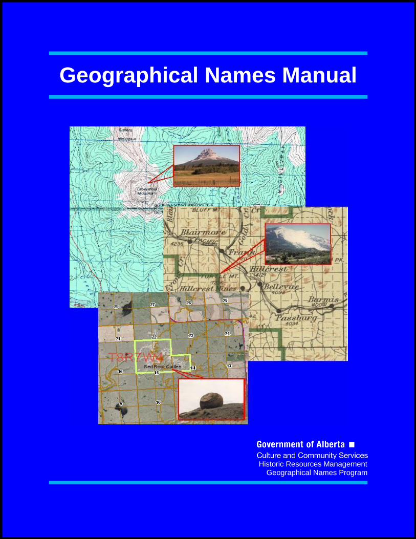
Cover Page Image Credits Map 1: Canada. Department of Natural Resources. NTS Map Sheet 82 G/10, 1979
Map 2: Canada. Department of the Interior. Pincher Creek Sectional Sheet No. 14, 1916 Map 3: VALTUS Imagery Services, North West
Geomatics, July 2010, licensed to Historic Resources Management Branch, Culture and Community Services, accessed February 2011. Image 1: Crowsnest Mountain, Crowsnest Pass (ATS
2-9-5-W5), Alberta Culture and Community Services. Image 2: Turtle Mountain/Frank Slide (ATS 24-7-4-
W5), Alberta Culture and Community Services Image 3: Red Rock Coulee, southwest of Medicine Hat
(ATS 8-8-W4), Alberta Culture and Community Services.

Geographical Names Manual P a g e | ii
Table of Contents
Foreword ............................................................................................................... i Cover Page Image Credits .................................................................................... i Table of Contents ................................................................................................. ii General Information .............................................................................................1
Introduction .................................................................................................1 A History of Geographical Naming ............................................................ 2 Current Legislative Authority ......................................................................5
Principles of Geographical Names .....................................................................8
Jurisdiction of the Alberta Historical Resources Foundation ........................8 Principles to Approve Names ......................................................................9 Standardization and Duplication ................................................................ 11 Dual Naming ............................................................................................. 11 Orthography .............................................................................................. 12 Aboriginal Naming ..................................................................................... 12 Format and Character of Names ............................................................... 13
Standards of Research ....................................................................................... 14
Preliminary Research ................................................................................ 14 Field Research .......................................................................................... 15 Library and Archival Research .................................................................. 17
Naming Submission Procedures ...................................................................... 19
Geographical Names Manual P a g e | 1
General Information
The application of names to geographical features is a public trust, carried out for the benefit of present and future
generations.
Introduction Why are place names important? Geographical names (or toponyms) play an important role in our society. They serve a practical purpose of labeling our surroundings and aiding navigation; and they allow us to orient ourselves in the landscape by providing recognizable points of reference. Toponyms also play an important cultural role by identifying our societal values and by serving as a medium to commemorate people and events. Does every place or feature already have a name? While every geographical feature does not have an official name, there are many officially unnamed features that do have unofficial or unrecognized names associated with them. In Canada, official names are those that are adopted by a regulatory government body. These official names appear on maps and in most publications produced by government agencies and departments. Many features have unofficial (local or historical names). Local names are those names used by the local population or by people associated with the feature to identify it. Historic names are names that are known to have been used in the past, but appear to be no longer in use. Local and historic names do not typically appear on official government maps; if they are used on these maps they are usually enclosed in quotation marks (“ “) to indicate their unofficial status. Does every geographical feature or place need a name? It is not essential for all features in the landscape to have official names. The naming of geographical features has been an important cultural expression since time immemorial. Our ancestors have named their surroundings and we continue to do so. It is important to recognize that future generations deserve the opportunity to name the landscape as well. Why are naming standards necessary? Imagine trying to find your way through an unfamiliar area; an area in which everyone has their own name for landmarks and features. Navigation through such a place would be difficult, time-consuming and confusing. Naming standards, recognized toponyms (or place names) and the use of official names on maps and other navigational aids is essential to prevent this kind of confusion. The accuracy of maps depends on consistent naming, spelling and locational practises. Each name must be researched and recorded as precisely as possible and the information used must be of the highest degree of clarity in order to ensure exact recording of names for the Province.
Geographical Names Manual P a g e | 2
A History of Geographical Naming
Geographical Naming in Canada
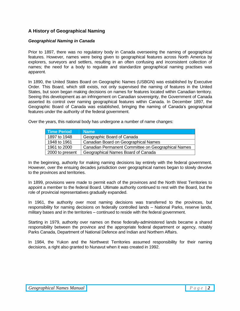
Prior to 1897, there was no regulatory body in Canada overseeing the naming of geographical features. However, names were being given to geographical features across North America by explorers, surveyors and settlers, resulting in an often confusing and inconsistent collection of names; the need for a body to regulate and standardize geographical naming practises was apparent. In 1890, the United States Board on Geographic Names (USBGN) was established by Executive Order. This Board, which still exists, not only supervised the naming of features in the United States, but soon began making decisions on names for features located within Canadian territory. Seeing this development as an infringement on Canadian sovereignty, the Government of Canada asserted its control over naming geographical features within Canada. In December 1897, the Geographic Board of Canada was established, bringing the naming of Canada’s geographical features under the authority of the federal government. Over the years, this national body has undergone a number of name changes:
Time Period Name
1897 to 1948 Geographic Board of Canada
1948 to 1961 Canadian Board on Geographical Names
1961 to 2000 Canadian Permanent Committee on Geographical Names
2000 to present Geographical Names Board of Canada
In the beginning, authority for making naming decisions lay entirely with the federal government. However, over the ensuing decades jurisdiction over geographical names began to slowly devolve to the provinces and territories. In 1899, provisions were made to permit each of the provinces and the North West Territories to appoint a member to the federal Board. Ultimate authority continued to rest with the Board, but the role of provincial representatives gradually expanded. In 1961, the authority over most naming decisions was transferred to the provinces, but responsibility for naming decisions on federally controlled lands – National Parks, reserve lands, military bases and in the territories – continued to reside with the federal government. Starting in 1979, authority over names on these federally-administered lands became a shared responsibility between the province and the appropriate federal department or agency, notably Parks Canada, Department of National Defence and Indian and Northern Affairs. In 1984, the Yukon and the Northwest Territories assumed responsibility for their naming decisions, a right also granted to Nunavut when it was created in 1992.
Geographical Names Manual P a g e | 3
Current Role of the Geographical Names Board of Canada
The Geographical Names Board of Canada (GNBC) exists today, but its mandate has changed considerably. The GNBC is no longer the final authority on all geographical naming decisions in the country. Today it serves as a coordinating body that aids the provincial and territorial programs. It does so by:
Co-ordinating questions of geographical nomenclature policy affecting Canada;
Advising on research and investigation into the origin and use of geographical names;
Promoting the use of official names by non-governmental organizations by sharing information and publishing decisions and the results of research.
Representing Canada’s interests and the United Nations Group of Experts on Geographical Names and on other international naming councils and at conferences.
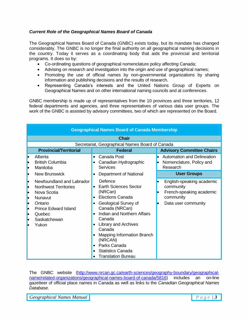
GNBC membership is made up of representatives from the 10 provinces and three territories, 12 federal departments and agencies, and three representatives of various data user groups. The work of the GNBC is assisted by advisory committees, two of which are represented on the Board.
Geographical Names Board of Canada Membership
Chair
Secretariat, Geographical Names Board of Canada
Provincial/Territorial Federal Advisory Committee Chairs
Alberta Canada Post Automation and Delineation
British Columbia
Manitoba
Canadian Hydrographic Services
Nomenclature, Policy and Research
New Brunswick Department of National User Groups
Newfoundland and Labrador
Northwest Territories
Nova Scotia
Nunavut
Defence
Earth Sciences Sector (NRCan)
Elections Canada
English-speaking academic community
French-speaking academic community
Ontario
Prince Edward Island
Quebec
Saskatchewan
Yukon
Geological Survey of Canada (NRCan)
Indian and Northern Affairs Canada
Library and Archives Canada
Mapping Information Branch (NRCAN)
Data user community
Parks Canada
Statistics Canada
Translation Bureau
The GNBC website (http://www.nrcan.gc.ca/earth-sciences/geography-boundary/geographical-name/related-organizations/geographical-names-board-of-canada/5816) includes an on-line gazetteer of official place names in Canada as well as links to the Canadian Geographical Names Database.
Geographical Names Manual P a g e | 4
Geographical Naming in Alberta Representation on the Geographic Board of Canada Alberta’s representatives to the Geographic Board of Canada have come from a variety of backgrounds and have included archivists, librarians, surveyors, and statisticians. The first representative was Katherine Hughes, Provincial Archivist and Librarian (1908-1915), followed by Lionel Charlesworth, Deputy Minister of Public Works and former Director of Surveying (1915-1925). From 1925 to the mid-1970s, Alberta’s representative on the GNBC has been either the Provincial Librarian (J. Ashton Jaffary, 1925-1930) or the Provincial Statistician (Hamilton Brownlee, 1936-1953; Daniel Istvanffy, 1953-1974). Since the mid-1970s, Alberta has been represented by a Director of the Historic Sites Service or Historic Resources Management Branch. Currently, Alberta’s representative member of the Geographical Names Board of Canada is the Assistant Deputy Minister of Culture and Community Services, Heritage Division. The Geographical Names Program Coordinator serves as the delegate, providing administrative support and representing Alberta when the Member is not able to. Geographic Board of Alberta In 1946, the Government of Alberta created the Geographic Board of Alberta (GBA) through an Order-in-Council. This body was created to enhance Alberta’s position regarding the naming of geographical features within the province. The GBA was mandated to examine all questions of geographical naming in the province and to work in conjunction with the GBC. In 1949, the GBA was formalized in legislation through the enactment of the Geographical Names Act. This placed the GBA under the authority of the Minister of Economic Affairs. The GBA was authorized to make decisions regarding geographical names in the province and was also responsible for conducting research; consulting and advising government departments, municipalities and other interested parties; and collaborating with federal naming authorities. The Board was to be composed of a president, secretary and up to three members-at-large. The early membership was composed of Morden H. Long, professor of History at the University of Alberta (chair and president), Duncan Innes, radio broadcaster and linguist (member-at-large), John H. Holloway, Director of Surveys (member-at-large). Edith Gostick, Provincial Librarian, served as the GBA’s secretary and handled most of the correspondence and administrative duties. Throughout this period, Ms. Gostick had the most influence on geographical naming in Alberta and held the position of secretary until her retirement in 1959. Her replacement as Provincial Librarian, Eric Holmgren, also became secretary of the board until its disbandment in 1974.
Geographical Names Manual P a g e | 5
Legislative Authority The Geographical Names Act was repealed on November 6, 1974, and geographical naming was added to the Historical Resources Act. Geographical Naming matters became the responsibility of the Historic Sites Board. In 1991 the Historic Sites Board was replaced by the Alberta Historical Resources Foundation. Section 18 of the Historical Resources Act (RSA 2000) deals with geographical names and is quoted below in full:
18(1) The name of any place or other geographical feature in Alberta that (a) was approved after March 31, 1949 and before January 1, 1975 by
the Geographic Board of Alberta under The Geographical Names Act, RSA 1970 c159
(b) was approved or changed after December 31, 1974 by the Historic Sites Board pursuant to this Act, or
(c) is approved or changed by the Foundation pursuant to subsection (2), is the authorized name of that place or feature for all purposes.
(2) The Foundation may, with the consent of the Minister, approve a name for, or
approve a change of the name for, any place or other geographical feature in Alberta.
(3) When the Foundation approves the name or changes the name of any place
or other geographical feature under this section, a notice signed by the secretary of the Foundation setting out the name approved or the change of name and the location of the place or other geographical feature to which the name applies, shall be published by the secretary in The Alberta Gazette.
(4) The Minister may make regulations
(a) prescribing standards and guidelines for the approval of names and changes of names by the Foundation;
(b) prescribing the duties of the Foundation with respect to nomenclature; (c) governing and requiring consultation by the Foundation with any
department, municipality, person or body of persons concerning the naming of, or the changing of the name of, any place or other geographical feature.
RSA 1980 cH-8 s14; 1992 c16 s4
Alberta Historical Resources Foundation The Alberta Historical Resources Foundation is a Crown Agency in right of Alberta, established in 1991 under the Alberta Historical Resources Act. Its mandate is to promote public awareness of Alberta’s heritage.
Geographical Names Manual P a g e | 6
The Board is composed of a Chairman and members from various areas of the province who are appointed by Order-in-Council to serve a term of office. As well as granting funds, advising and making recommendations to the Minister of Culture and Community Services on matters concerning preservation and protection of historical resources in Alberta, the Board makes decisions on geographical names. Alberta Geographical Names Program Program and Staff The Geographical Names Program in Alberta is under the direction of the Director of Historic Resources Management, Alberta Culture and Community Services. The Program carries undertakes research on Alberta’s naming heritage and maintains the records related to Alberta’s official and unofficial names. Program staff are also responsible for evaluating new naming proposals and for advising the Board of the Alberta Historical Resources Foundation during their decision-making deliberations. Program staff includes:
The program coordinator is responsible for the:
General direction and administration of the Program;
implementation of procedures;
liaison with governmental organisations from the local to international levels on toponymic matters;
dissemination of geographical names information to the general public and interested parties;
maintenance of records;
toponymic field and archival research;
and other duties related to geographical names proposals.
From time to time, persons employed in temporary wage positions, especially under the temporary employment programs.
When the need and opportunity arises, professional services are occasionally obtained under contract.
Geographical Naming Proposals
Most new names are derived from the general public and are most often submitted for approval when a name is absolutely required to identify a specific geographical feature. Whenever possible the Geographical Names Program submits name proposals collected from field studies conducted with available manpower. However, it has been the practise of the Government of Alberta since the 1970s to be reactive, rather than proactive regarding geographical names. The Government of Alberta believes that as geographical names belong to all Albertans it should be left up to individual Albertans to propose new names or changes to existing names rather than to impose these names from above. The consideration of new names may require considerable time particularly due to the investigation and research required. There are two types of research that are conducted for every name
Geographical Names Manual P a g e | 7
submission. The first is documentary research to gather information from both published and archival documents. The second is field research. Determining local usage for a geographical name is most easily done through interviewing local residents, former local residents, and others expert in the immediate area of the feature being researched. In cases where a new name is required established local names are given first consideration, followed by any known historic names. The publication of unauthorised names in reports and on maps does not necessarily result in official recognition. While it is impossible for the Program to insist that only official names be used on locally produced maps or in publications, the practice of annotating unofficial or local names within quotation marks (“ ”) is acceptable and encouraged in order to distinguish between unofficial names and those that have not received official acceptance.

Geographical Names Manual P a g e | 8
Principles of Geographical Names
Jurisdiction of the Alberta Historical Resources Foundation
PRINCIPLE 1(A) – For Geographical Features and Places The Board's principal area of responsibility, with respect to geographical names, is the naming and control of names given to natural geographical features, unincorporated populated places, localities and other cultural geographical entities. Names approved by the Board, and ratified by the Minister of Culture and Community Services, are official for all municipal, provincial and federal maps, charts, gazetteers and related publications. Notes: Natural geographical features include lakes, mountains, creeks, and rivers, etc. Cultural features include municipalities, parks, dams and reservoirs. PRINCIPLE 1(B) – For Ensuring a Complete Inventory of Statutory Names The names of territorial divisions and places governed by other provincial or federal statutes, including incorporated municipalities, hamlets, Indian reserves, provincial or federal parks, etc. should be transmitted to the Geographical Names Program for entry into the Inventory of Geographical Names. It shall be the responsibility of the Geographical Names Program to ensure that the inventory is complete and accurate. Notes: While this principle does not direct or define the jurisdiction of the Board, it is included here
in order that awareness of the Board's responsibility is increased and in order that all agencies be made aware that authority for geographical naming does rest with the Alberta Historical Resources Foundation Board. Moreover, this principle ensures that the Geographical Names Program is active in its approach to notifying all concerned of the jurisdiction of the Board.
The inventory of Geographical Names includes an inventory of Official, Unofficial (local and historical), Rescinded, Rejected and Pending geographical names.
Geographical Names Manual P a g e | 9
PRINCIPLE 1(C) – For Other Cultural Features The naming of roads, dams, reservoirs, trails and other cultural-topographical features not governed by other statutory authority may be considered for entry into the official record. The Alberta Historical Resources Foundation Board may make naming recommendations on dams and reservoirs, small man-made water features, localities, railway stations, points and sidings. Notes: Again, this principle assures that the Geographical Names Program is active in ensuring
that its inventory is complete and up-to-date. Such names must be in well-established current local use and, in the judgement of the
Board, be essential geographical references for official maps, charts, gazetteers and publications for the area concerned.
PRINCIPLE 1(D) – For Ensuring Public Awareness The Board, through the office of the Geographical Names Program, will assist the general public and will advise other governmental bodies at the municipal, provincial and federal level in all matters relating to geographical names and naming in the province.
Principles to Approve Names
PRINCIPLE 2(A) – Local Usage The Board accords first consideration to names that are well established and in current local use. PRINCIPLE 2(B) – Historical Names Where no current name is known to exist for a feature for which an official name is required but for which an historical name is discussed, the historical name will be given first consideration by the Board. PRINCIPLE 2(C) – Descriptive Naming In instances where a name is required for a feature for which neither a current or historical name exists, first consideration shall be given by the Board to the adoption of a name uniquely descriptive of the feature itself. Notes: Such names as Long Lake and The Big Rock fall within this category.
Geographical Names Manual P a g e | 10
PRINCIPLE 2(D) – Commemorative Naming Where it does not contravene Principles 2A-2C, the Board may consider a commemorative name for an unnamed geographical feature identified by an applicant, and verified as unnamed by the Geographical Names Program, only when the following criteria have been met:
Personal names, used for commemorative purposes, are given to geographical features posthumously;
A minimum of five years must elapse from the date of death before a commemorative name proposal will be considered. (Please note that any proposal submitted prematurely will be returned to the applicant);
Proposals are not accepted from the family of the deceased;
A person whose contribution to an area was as a result of his/her employment will not normally be considered for commemoration in this fashion;
If an event is being commemorated, it must have occurred at least five years in the past;
The person or event being commemorated must have made, in the opinion of the Board, an outstanding contribution to the cultural legacy of the Province of Alberta, or to the development of the area, feature, or place in question. Evidence must be available to demonstrate that this contribution is recognised and acknowledged by the general public;
Geographical features are not named to commemorate victims or mark the location of mishaps, accidents or tragedies;
The Board must be satisfied that the proposed commemorative name meets with local approval;
The applicant must demonstrate that the proposal has been formulated objectively, and the proposed name is acceptable to the public beyond a single person or a special interest group.
Notes: While commemorative naming has occurred in the past, these are not precedents. This
policy keeps Alberta in line with the national and international naming guidelines as endorsed by the Geographical Names Board of Canada.
PRINCIPLE 2(E) – Naming After Living Persons The naming of a natural geographical feature, unincorporated place, or locality after a living person will not be done. Notes: While naming after living persons has occurred in the past (notably Mount Michener in
1979), these are not precedents. This policy keeps Alberta in line with the national and international naming guidelines as endorsed by the Geographical Names Board of Canada.
PRINCIPLE 2(F) – Ownership of Land Ownership of land is not, in itself, ground for recommending the adoption of a personal name for a geographical feature, place or locality. This principle is superseded by that concerning local usage. Notes: See Principle 2(D) - Commemorative Naming, unless it falls within Principle 2(A) - Local
Usage.
Geographical Names Manual P a g e | 11
PRINCIPLE 2(G) – Buying and Selling of Names A geographical name, or the right to name a geographical feature, cannot be bought or sold, raffled or otherwise conferred through contest or auction. PRINCIPLE 2(H) – Commercial Product or Company Names Company or commercial product names are not acceptable as geographical names unless there is long-standing usage of the name by the general public. Proposals for new names or changes to existing names that are intended to promote or enhance a commercial venture will not be considered.
Standardization and Duplication
PRINCIPLE 3(A) – Name Uniformity The spelling of geographical names having a common origin applied or used in names given to features, places and localities occupying the same geographical area, should be the same. Notes: The name Wabasca and its derivatives (Wabaska, Wabiskah, Wabaskaw, and Wapiskow)
are an example. The official spelling is Wabasca and the names of all post offices, railway stations and airports should and in this case do, conform to the official spelling.
PRINCIPLE 3(B) – Use of Qualifying Terms Where a geographical name has become a source of confusion because it has been applied to two or more topographical features of the same sort (e.g. three lakes, two rivers, etc.) in the same geographical area; or, it is used as a single name for a topographical complex feature or place made up of separate parts (e.g. river-tributary system, or chain of interconnected lakes), the Board may recommend adoption of qualifying terms such as upper, lower, big, little, north, south, etc. This introduced term should be appropriate to the feature and should conform to local usage. Notes: Big Johnson Lake and Little Johnson Lake are two such names, which, at local urging,
were recommended with qualifiers to identify each separate feature independently.
Dual Naming
PRINCIPLE 4 – Circumstances and Acceptability Where a geographical feature has two names in approximately equal local use, due to the original possession of a name and the later application of a different name, the Board may apply a dual name to that feature, and recognise both usages. Notes: One such example is Mount Laurie (Îyâmnathka). This mountain was officially named in
1961 in honour of John Lee Laurie, B.A., LL.D. (1900–1959). The mountain had been locally well known, particularly by the Stoney Nakoda, by its traditional name of Îyâmnathka (typically pronounced “Yamnuska”), which translates as “flat-surfaced rock or mountain.” On December 5, 1984, the Minister of Culture and Multiculturalism, on the recommendation of the Historic Sites Board, officially recognised the name in a dual format, with diacritics, in an attempt to capture the both the official name and the traditional name.
Geographical Names Manual P a g e | 12
Orthography
PRINCIPLE 5(A) – Possessive Forms A geographical name represented in either the English possessive or hyphenated form will be considered for adoption in that form by the Board only if it is consistent with and supported by a well-established and current local usage. Notes: Names such as Jerry the Bird's Bottom fall into this category. PRINCIPLE 5(B) – Names in Languages Other Than English The Board may recommend names in languages other than English even if they appear in orthographies not Latin in origin. Notes: In this way, the Board is able to recognise the cultural reality of the area as well as provide
the best representation of the cultural landscape. A secondary consideration would be to apply the best solution that allows widespread comfortable usage of the name without compromising the cultural reality it represents.
Aboriginal Naming
PRINCIPLE 6(A) – Naming in Non-Reserve First Nation Lands Where a proposed geographical feature exists within the established boundaries of Non-Reserve First Nation lands, the Board shall ensure that the appropriate council or councils for that area has been contacted and concurs with the naming proposal before a recommendation is made. Notes: This principle primarily ensures that First Nation groups are not only made aware of
geographical naming in their areas but also ensures that groups are guaranteed some input into the naming of geographical features in the parts of the province where they are actively involved, such as Indian Reserves, and also in adjacent lands.
PRINCIPLE 6(B) – Form and Character of Aboriginal Names In areas of the province where Aboriginal names are well established and in current local use, special consideration shall be given to their adoption as official names. The spellings of these names should conform to the linguistic rules of the concerned language group and shall conform to and be ratified by the recognised linguistic experts recognised by the particular language group.
Geographical Names Manual P a g e | 13
Form and Character of Names
PRINCIPLE 7(A) – Name Integrity The unique or local character of an established geographical name shall be respected. Any name alteration, translation, deletion or symbolisation not approved or adopted locally is discouraged and opposed in principle. Notes: All official names approved by the Board should be used in their correct and officially
recognised form. If there is contention, however, the name should be investigated and, if local usage warrants, the locally acceptable form of the name should be officially adopted.
PRINCIPLE 7(B) – Unacceptable Names In considering the adoption of the geographical names for official use, the Board shall withhold recommendation or approval of any names, which, in its estimation, are derogatory, obscene, or blasphemous, or can be construed as advertising a particular commercial or industrial product or enterprise
Geographical Names Manual P a g e | 14
Standards of Research
Preliminary Research Procedures STEP 1 – Receipt of Application and Acknowledgement Upon receipt of a request for naming:
An acknowledgement is sent to the initiator with an explanation of the procedures leading to a decision.
If the initiator has not already done so, an Application for a Naming a Geographical Feature is completed by the applicant, with particular attention to the delineation and location of the feature. The application form can be found at: http://culture.alberta.ca/heritage/resourcemanagement/archaeologyhistory/geographical/pdf/Geographical_Name_Application.pdf.
STEP 2 – Basic Reference Check A basic check of the following official records is made to determine whether the proposed name is duplicated and whether it is indeed unnamed: (a) Alberta Geographical Names Database. This is the most up-to-date cumulative source of
geographical names listings in the Province. This database will also show any proposed, accepted or rejected names for the feature.
(b) Canadian Geographic Names Database at the GNBC website. It includes all current official names and most rescinded names.
(c) Maps – All available maps of the area in which the feature is located:
NTS – Editions of the 1:50,000 and 1:250,000 scale map;
Provincial Maps – Provincial Base Map (1:50,000), Provincial Access Series, Forest Cover Series, Road Maps, etc.
Historical maps – e.g. Early explorers (Palliser, David Thompson, Arrowsmith), homestead area maps, maps accompanying official reports (Geological Survey, Topographical Survey, Boundary Survey, etc.), sectional maps, etc.
(d) Secondary Official Listing
Alberta Gazette
Municipalities (incorporation dates, etc.)
Railway timetables
Post Office listings
Historical directories
Geographical Names Manual P a g e | 15
Field Research Procedures STEP 1 – Government Sources Field research is undertaken, as the primary step, in order to establish local usage of the name of a geographical feature. Only appropriate interviews with a representative cross-section of the local population can ensure that the information gathered reflects current local usage. As well, field research can help in identifying historical names for all geographical features and any alternate names for proposed names or officially established names. The most effective, and frequently employed, method involves the co-operation of:
Local Governments Provincial Government Departments
Federal Government Departments
Planning departments Environment Canada Post
Names advisory committees
Agriculture, Food and Rural Development
Indian Affairs and Northern Development
District representatives Municipal Affairs Natural Resources Canada
Rural municipality reeves Infrastructure
Municipal secretaries
Mayors
These government representatives may be able to indicate knowledgeable individuals representing a variety of age and occupational groups while also giving “official” opinion on the name. STEP 2 – Local Sources Other local sources that will frequently reveal reliable information regarding potential information include:
Newspaper offices
Librarians or archivists
Provincial and local historical societies
Senior citizens' homes
Outfitters, guides, and trappers STEP 3 – Field Interviews The number of people interviewed for each geographical name will vary depending on the type of feature being researched. Interviewing a number of individuals who represent a wide spectrum of local and interest groups will give a fair indication of the extent of usage of any particular geographical name. Ideally, then, the interview sample should include unrelated individuals from various age groups. Occupational groups should likewise be representative and may include, for example, farmers, ranchers, outfitters, oil field and forestry workers, along with others who, through their work or leisure, may by familiar with geographical features in a given area.
Geographical Names Manual P a g e | 16
The best respondents, no doubt, are those who live in very close proximity to the actual feature. Where residents are not always available in the immediate neighbourhood, it is necessary to seek interviews at the closest populated places. Brief Guide to Conducting Field Interviews Simply approaching an individual, whether that person is knowledgeable about the area or not, with a general query about unofficial geographical names, rarely produces satisfactory results. In most instances, local individuals will not be able to distinguish official from unofficial names. There are two methods of identifying the features on which information is desired. The most direct method is to point to the feature on a large-scale map (NTS 1:50,000) and simply ask: “Does this feature have a name?” If the individual being interviewed has the ability to read a topographical map, then this method should produce positive results. If the individual cannot read a topographical map, then the feature and its location (distance and direction) must be verbally described. For example, “Does the small seasonal stream flowing south-east into the North Saskatchewan Rivers two kilometres north-west of here have a name?” Alternatively, the individual could be taken to the site if possible. It is far more productive to ask specific questions about specific features and once the local names for features have been determined, the following questions should be answered for each name:
What is the origin of the name?
Who named the feature?
When was the feature named?
What is the correct spelling of the name?
What is the exact extent of this feature?
How well known locally is the name?
Are you aware of any other names for this feature?
Do you know of or have any maps or books that show this name?
Are there any other local individuals who may have more information concerning this name?
All informants should be made aware that they will be quoted in submissions to the Alberta Historical Resources Foundation Board. The field researcher should at the outset identify himself/herself and his/her employer to the interviewee. In order to obtain information that is as free from bias as possible, informants should not initially be informed of information gathered from alternative sources. If a feature is well known locally then the informant should know the name and will not need prompting. If an informant does not give a name for specific feature for which other informants had supplied a name, then other names may be tested on the informant. The response must be recorded with a note stating that prompting was required. Field maps should not show any unofficial or locally gathered information in order to preserve objectivity. All such information should be kept apart from field maps. A system of co-ordinated numbers has proved to be the most effective method.
Geographical Names Manual P a g e | 17
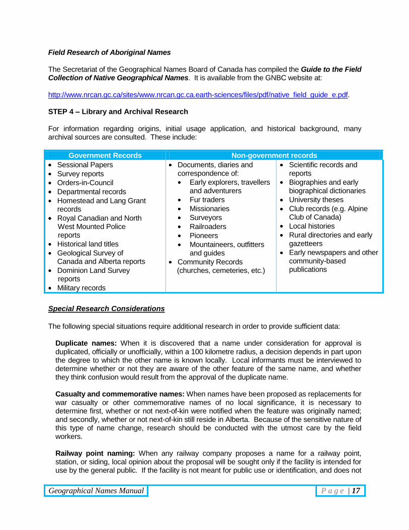
Field Research of Aboriginal Names The Secretariat of the Geographical Names Board of Canada has compiled the Guide to the Field Collection of Native Geographical Names. It is available from the GNBC website at: http://www.nrcan.gc.ca/sites/www.nrcan.gc.ca.earth-sciences/files/pdf/native_field_guide_e.pdf. STEP 4 – Library and Archival Research For information regarding origins, initial usage application, and historical background, many archival sources are consulted. These include:
Government Records Non-government records
Sessional Papers
Survey reports
Orders-in-Council
Departmental records
Homestead and Lang Grant records
Royal Canadian and North West Mounted Police reports
Historical land titles
Geological Survey of Canada and Alberta reports
Dominion Land Survey reports
Military records
Documents, diaries and correspondence of:
Early explorers, travellers and adventurers
Fur traders
Missionaries
Surveyors
Railroaders
Pioneers
Mountaineers, outfitters and guides
Community Records (churches, cemeteries, etc.)
Scientific records and reports
Biographies and early biographical dictionaries
University theses
Club records (e.g. Alpine Club of Canada)
Local histories
Rural directories and early gazetteers
Early newspapers and other community-based publications
Special Research Considerations
The following special situations require additional research in order to provide sufficient data:
Duplicate names: When it is discovered that a name under consideration for approval is duplicated, officially or unofficially, within a 100 kilometre radius, a decision depends in part upon the degree to which the other name is known locally. Local informants must be interviewed to determine whether or not they are aware of the other feature of the same name, and whether they think confusion would result from the approval of the duplicate name.
Casualty and commemorative names: When names have been proposed as replacements for war casualty or other commemorative names of no local significance, it is necessary to determine first, whether or not next-of-kin were notified when the feature was originally named; and secondly, whether or not next-of-kin still reside in Alberta. Because of the sensitive nature of this type of name change, research should be conducted with the utmost care by the field workers.
Railway point naming: When any railway company proposes a name for a railway point, station, or siding, local opinion about the proposal will be sought only if the facility is intended for use by the general public. If the facility is not meant for public use or identification, and does not
Geographical Names Manual P a g e | 18
already have a local name the research will be limited to a check for name duplication within the province. Conflicting alternatives: When a naming controversy arises, such as when local opinion is divided in favour of two or more names for the same feature, more than the usual amount of research will be necessary to calculate local opinion accurately and comprehensively. This can be approached by:
Extensive polling of a minimum of 20 to 30 people by telephone; through locally sponsored petition campaigns; or through the local newspaper, or other local media;
Polling conducted by the local or municipal government which would then make a recommendation based on the results of the poll to Board;
Inviting representatives of the opposing sides to appear before the Board and present their case for approval or rejection of the name.
According to the “Principles of Geographical Naming in Alberta,” dual names (or multiple names) are acceptable if sufficient local opinion to support the name exists.
Geographical Names Manual P a g e | 19
Naming Submission Procedures
Process
Preparation of the Data Report
Upon completion of the research for a naming proposal, the staff of the Geographical Names Program adds the information to the Alberta Geographical Names Database, and submits the applications along with annotated portions of NTS maps to the members of the Board for consideration at an upcoming meeting. The information contained in the database includes:
Name of feature, appropriate generic, and feature type.
Indication if the proposal is a new name, a change to an existing name (status, location, spelling, etc.).
NTS 1:50,000 map sheet number and name.
Identity of the person or organization that proposed the name.
Description of feature;
Headwaters, mouth, direction of flow, approximate length for watercourses,
Altitude for hills, mountains, passes, etc.,
Area of lakes, flats, plains, meadows, wetlands, etc.
Location of feature;
Latitude and longitude, Alberta Township System, UTM reference (if possible), etc.
Written description of the location and distance of the feature in reference to nearby major features.
Origin summary.
Details of field interviews, with direct quotations where appropriate.
Quotations from all written sources, including correspondence;
All source material should be referenced completely.
Photographs of the feature (if possible). Submission to the Board of the Alberta Historical Resources Foundation When research on a proposed name has been completed and the Data Report ahs been prepared, the information is presented to the Board of the Alberta Historical Resources Foundation for consideration. The Board's decisions are based on the following considerations:
Application of “Principles for Geographical Naming in Alberta;”
Consensus of opinion of local residents and those officials who were interviewed;
Knowledge of the area. The Geographical Names Program will make a recommendation to the Board. The Board then renders a decision. Decisions are recorded in the minutes of the Alberta Historical Resources Foundation Board.
Geographical Names Manual P a g e | 20
Decision Sheets The Coordinator of the Alberta Geographical Names Program will prepare a Decision Sheet. This document must indicate:
The type of decision (Approval, Rejection, Change of Form, Change of Location, etc);
The name of the feature;
The feature type;
Locational coordinates (latitude/longitude, ATS, etc.);
Textual description of the feature and its location;
A summary of the name’s origin;
The date and location of the Alberta Historical Resources Foundation Board meeting where the decision was made.
The Decision Sheet must be signed and dated by the proper authority of the Board, typically the Chair or Acting Chair. Notification of the Members of the Legislative Assembly of Alberta Following the signing of the Decision Sheet by the Board representative, an informational package about the feature and name is sent to all Members of the Legislative Assembly (MLA) representing the constituencies in which the feature is located within or crosses the boundaries of. This package notifies the MLAs of the decision and solicits any opinions they may have about the feature, name or decision. Notification of the MLAs is done through correspondence (either memorandum or letter) from the Minister of Culture and Community Services. Ministerial Briefing and Signature Under the provisions of the Historical Resources Act (RSA 2000), section 18(2), decisions on geographical names made by the Board of the Alberta Historical Resources Foundation are subject to the concurrence of the Minister of Culture and Community Services. Once the MLAs have responded, the Decision Sheet (signed by the AHRF representative) and an informational package are forwarded to the Minister of Culture and Community Services. If in agreement with the decision rendered by the Board, the Minister (or appointed delegated authority) will sign and date the Decision Sheet and return it to the Geographical Names Program for filing.
The Decision Sheets are the official record of the geographical names decision and must be correct, signed
by the proper authorities and retained by the Alberta Geographical Names Program

Geographical Names Manual P a g e | 21
Notification of Approval Following the signing of the Decision Sheet by the Board and the Minister, other parties must be notified of the decision. The Notification of Approval Process differs based on the region of the province the geographical feature is found. There are four distinct categories of regions that affect the Notification of Approval Process. These are:
1. Features in areas of the province solely under provincial jurisdiction; 2. Features in areas of the province that are under federal jurisdiction (excluding Indian
Reserves); 3. Features that are located within an Indian Reserve; 4. Features that are on or cross a provincial or national boundary.
Names in Areas of Provincial Jurisdiction Following the signing of the Decision Sheet by both the Chair of the Alberta Historical Resource Foundation and the Minister of Culture and Community Services, notifications, consisting of copies of the decision sheets and a location map are sent to:
Other provincial government offices, including provincial mapping agencies;
All interested parties, Including:
The originator of the naming request or the applicant,
All persons listed as informants or supporters on the application form,
Any persons who had made comments on the name or submitted an opinion or information about the name or feature to members of the Alberta Historical Resources Foundation and/or staff of the Alberta Geographical Names Program.
Non-governmental mapping or information agencies;
Secretariat, Geographical Names Board of Canada;
Notifying the federal authorities will ensure that the name is included in the Canadian Geographical Names Database and will be included on updated federal government maps.
Alberta Gazette
Section 18(3) of the Historical Resources Act requires notice of all newly adopted official names, rescinded official names or alterations to existing official names be published in Alberta Gazette.
Members of the Legislative Assembly
The MLAs representing the constituency in which the feature is located or crosses must be notified once a decision is made official.
Names in Areas of Federal Jurisdiction (excluding Indian Reserves)
Names and name changes for features located on or pass through a part of the province under federal jurisdiction require the
approval of both the Province of Alberta and the relevant federal Department or Agency.
These cases typically involve features located within
National Parks and National Historic Sites (Parks Canada), and
Canadian Forces Bases and Reserves (Department of National Defence).
Geographical Names Manual P a g e | 22
For those features in Alberta that are wholly or partially located on federally controlled lands the Alberta Historical Resources Foundation Board and the Minister of Culture and Community Services are not the final naming authority and additional steps must be taken before the naming decision is official. Provincially Initiatives Following the signing of the Decision Sheet by the Chair of the Alberta Historical Resource Foundation and the Minister of Culture and Community Services, copies of the Decision Sheet, an information package and copies of relevant maps and images are submitted to the Secretariat, Geographical Names Board of Canada. The Secretariat of the GNBC produces a Federal Authority Decision Sheet indicating when the provincial decision had been made and when it was signed by the provincial authorities. The new Decision Sheet also provides space for the signature of the relevant federal authority. The Federal Decision Sheet is then forwarded to the relevant department or agency along with the information package provided by the province. The federal department or agency evaluates the proposed name based on their naming standards and guidelines and renders a decision to accept or reject the provincial submission and signs the Federal Decision Sheet. The GNBC Secretariat forwards a copy of this Federal Decision Sheet (usually pink in colour) to the Alberta Geographical Names Program.
The Federal Decision Sheets are, along with the standard Decision Sheets, the official record of the geographical names
decision and must be retained by the Alberta Geographical Names Program
Once the Federal Decision Sheet is received by the Alberta Geographical Names Program, the notification process continues as normal. Federal Initiatives In cases where a naming proposal has been initiated by federal authorities, the GNBC Secretariat notifies the Alberta Geographical Names Program of the decision. The proposed name is then evaluated according to provincial naming standards and is submitted to the Board of the Alberta Historical Resources Foundation for a decision and is submitted to the Minister of Culture and Community Services for approval. The Minister signs both the standard, provincial Decision Sheet as well as the Federal Decision Sheet. Copies of both documents are submitted back to the GNBC Secretariat. Conflict Arbitration If there is a disagreement between Provincial and Federal naming authorities about a proposed name, the matter is placed before a Special Committee convened by the Chair of the Geographical names Board of Canada. This committee is composed of the members representing both the province and the federal department or agency as well as two or more other GNBC members. The Special Committee attempts to reach an agreement satisfactory to all parties. If the Special Committee is not able to reach an agreement, the matter is referred for discussion at the next annual meeting of the Geographical Names Board of Canada.
Geographical Names Manual P a g e | 23
Names of Features Involving Indian Reserves There are two types of features involving Indian Reserves, those that are entirely within the boundaries of a reserve and those that lie on or cross the boundaries of a reserve. Features Within a Reserve In 2010, the Department of Indian and Northern Affairs (now Aboriginal Affairs and Northern Development), indicated that it would hand over decisions on geographical names for features located within the boundaries of Indian Reserves to the Aboriginal community residing on or using the reserve. The Geographical Names Board of Canada encourages First Nations Councils and the Provincial naming programs to work collaboratively in researching and evaluating geographical naming proposals. Decisions regarding these names must be endorsed by the provincial authority through its geographical naming procedures and by the Aboriginal community through a Band Council Resolution (or equivalent). A copy of this resolution should be provided to the Alberta Geographical Names Program as part of the official record of decision. Once a naming decision has been made and endorsed by the Province and the Band, the notification process continues as per normal. Features Partially Within a Reserve Naming proposals for geographical features that cross the boundary of an Indian Reserve require the full participation and agreement of the affected Aboriginal group. The local Band Council, if it is not the originator of the proposal, must be notified of the naming proposal by the applicant. Evidence of correspondence notifying the Band Council of the proposed name must be provided by the applicant before a naming application can be accepted. Once the Band Council has been notified and naming application is received by the Alberta Geographical Names Program, research on the proposed name and geographical feature will be undertaken. The participation of the affected Aboriginal group is encouraged and consultations with the affected Aboriginal group are required. Both the provincial naming authorities (Alberta Historical Resources Foundation and the Minister of Culture and Community Services) and the local Band Council must reach an agreement on the naming proposal before it can be adopted. The affected Aboriginal group may provide evidence of their decision on the naming proposal through a Band Council Resolution (or equivalent); a copy of which should be provided to the Alberta Geographical Names Program. Otherwise, the naming process proceeds as per normal. Names of Features that Cross a Provincial Boundary Some geographical features in Alberta cross a provincial boundary, either into the provinces of Saskatchewan and British Columbia, the Northwest Territories or the State of Montana. The Alberta Historical Resources Foundation Board and the Minister of Culture and Community Services are not the final naming authority for these features and additional steps must be taken before a naming decision is official.
Geographical Names Manual P a g e | 24
Upon receipt of an application the process continues as per normal. Following the signing of the Decision Sheet by the Chair of the Alberta Historical Resource Foundation and the Minister of Culture and Community Services, copies of the Decision Sheet, an information package and copies of relevant maps and images are submitted to the Secretariat, Geographical Names Board of Canada. The Secretariat of the GNBC forwards the information to the appropriate naming authority for the affected jurisdiction. Namely the:
Saskatchewan Geographic Names Program;
GeoBC, Geographical Names Office;
Northwest Territories Cultural Places Program;
United States Board on Geographical Names; and
Montana State Names Authority. The naming authority of the affected jurisdiction evaluates the proposed name based on its own naming policies and criteria. Once a decision has been rendered, a copy of the required documentation is communicated back the GNBC Secretariat, which in turn forwards the decision and information back to the province. Once the other jurisdiction’s decision is received, the naming process continues as normal. In cases where a naming proposal has been initiated by another jurisdiction which affects a geographical feature within Alberta, the GNBC Secretariat notifies the Alberta Geographical Names Program of the other jurisdiction’s decision. The proposed name is then evaluated according to provincial naming standards and is submitted to the Board of the Alberta Historical Resources Foundation for a decision and is submitted to the Minister of Culture and Community Spirit for approval. The Minister signs both the standard, provincial Decision Sheet as well as the Federal Decision Sheet. Copies of both documents are submitted back to the GNBC Secretariat. If there is a disagreement between the naming authorities of Alberta, Saskatchewan, British Columbia or the Northwest Territories about a proposed name, the matter is placed before a Special Committee convened by the Chair of the Geographical Names Board of Canada. This committee is composed of the members representing the affected jurisdictions as well as two or more other GNBC members. The Special Committee attempts to reach an agreement satisfactory to all parties. If the Special Committee is not able to reach an agreement, the matter is referred for discussion at the next annual meeting of the Geographical Names Board of Canada. There is no formal process for arbitrating disagreements between the naming authorities of the Province of Alberta and the State of Montana and the United States Board on Geographic Names.