geography grade 12 geomorphology 03 july...
TRANSCRIPT

GEOGRAPHY Grade 12
Page 1
GEOMORPHOLOGY 03 JULY 2014
Checklist
Make sure you:
Can discuss and apply concepts related to Drainage Basins in South Africa
Can discuss and apply the following aspects of Fluvial Processes: o River Profiles o River Grading o River Rejuvenation o Identification, description and formation of fluvial landforms o River Capture/Stream Piracy o Superimposed and antecedent drainage patterns
Understand Catchment and River Management.
Exam Questions
Question 1
Study FIGURE 1 and answer the questions that follow
1.1 Identify Stages A, B and C. (3x1) (3)
1.2 Draw rough cross-section for each of the stages identified in QUESTION 1.1 (3x1) (3)
1.3 a) Identify feature D
b) At which stage of the river is feature 1 found (1x1) (1)
c) Give a reason for your answer to QUESTION 1.3 a) (1x2) (2)
d) Explain the formation of feature D (2x2) (4) TOTAL 14
GEOGRAPHY Grade 12
Page 2
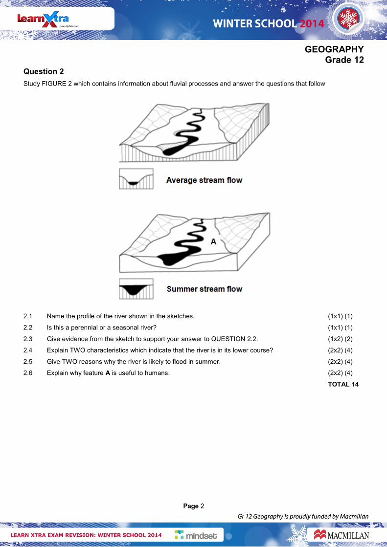
Question 2
Study FIGURE 2 which contains information about fluvial processes and answer the questions that follow
2.1 Name the profile of the river shown in the sketches. (1x1) (1)
2.2 Is this a perennial or a seasonal river? (1x1) (1)
2.3 Give evidence from the sketch to support your answer to QUESTION 2.2. (1x2) (2)
2.4 Explain TWO characteristics which indicate that the river is in its lower course? (2x2) (4)
2.5 Give TWO reasons why the river is likely to flood in summer. (2x2) (4)
2.6 Explain why feature A is useful to humans. (2x2) (4)
TOTAL 14
GEOGRAPHY Grade 12
Page 3
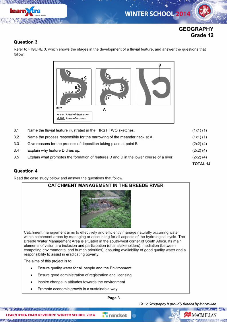
Question 3
Refer to FIGURE 3, which shows the stages in the development of a fluvial feature, and answer the questions that
follow.
3.1 Name the fluvial feature illustrated in the FIRST TWO sketches. (1x1) (1)
3.2 Name the process responsible for the narrowing of the meander neck at A. (1x1) (1)
3.3 Give reasons for the process of deposition taking place at point B. (2x2) (4)
3.4 Explain why feature D dries up. (2x2) (4)
3.5 Explain what promotes the formation of features B and D in the lower course of a river. (2x2) (4)
TOTAL 14
Question 4
Read the case study below and answer the questions that follow.
CATCHMENT MANAGEMENT IN THE BREEDE RIVER
Catchment management aims to effectively and efficiently manage naturally occurring water within catchment areas by managing or accounting for all aspects of the hydrological cycle. The Breede Water Management Area is situated in the south-west corner of South Africa. Its main elements of vision are inclusion and participation (of all stakeholders), mediation (between competing environmental and human priorities), ensuring availability of good quality water and a responsibility to assist in eradicating poverty.
The aims of this project is to:
Ensure quality water for all people and the Environment
Ensure good administration of registration and licensing
Inspire change in attitudes towards the environment
Promote economic growth in a sustainable way

GEOGRAPHY Grade 12
Page 4
4.1 Define the following terms:
a) Catchment area
b) Catchment management (2x1) (2)
4.2 State TWO ways in which man is having a negative impact on the catchment Areas. (2x1) (2)
4.3 State FOUR aims of the Breede River Catchment Management Project. (4x1) (4)
4.4 Explain the benefits of these aims to man and/or the environment. (4x2) (8)
TOTAL 16
Question 5
Refer FIGURE 5 is based on a drainage basin and its longitudinal profile.
5.1 Define the term drainage basin. (1x1) (1)
5.2 Explain the term longitudinal profile. (1x1) (1)
5.3 What evidence suggests that the longitudinal profile is a graded profile? (1x1) (1)
5.4 Name and describe the underlying rock structure associated with stream pattern B. (1+2) (3)
5.5 Give a reason why the river follows a meandering path in the middle course. (1x2) (2)
5.6 The fluvial landforms in the upper and lower course of a river differ greatly. Write a paragraph in which you explain how the different stream-flow and erosion processes are responsible for the development of different landforms in the upper and lower courses. (4x2) (8)
TOTAL 16
GEOGRAPHY Grade 12
Page 5
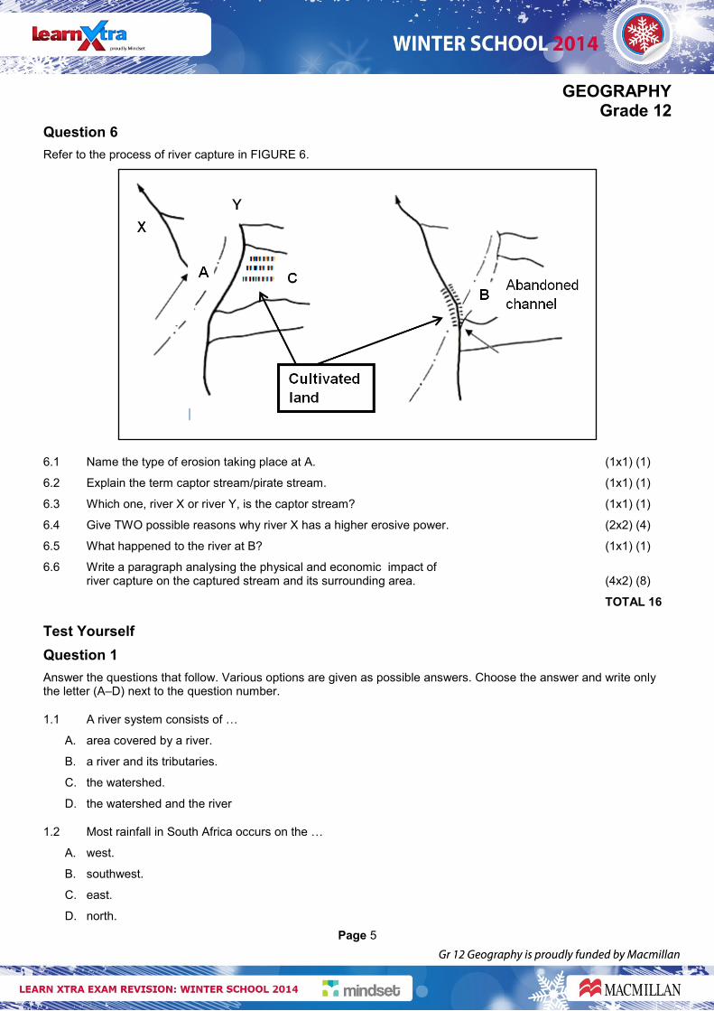
Question 6
Refer to the process of river capture in FIGURE 6.
6.1 Name the type of erosion taking place at A. (1x1) (1)
6.2 Explain the term captor stream/pirate stream. (1x1) (1)
6.3 Which one, river X or river Y, is the captor stream? (1x1) (1)
6.4 Give TWO possible reasons why river X has a higher erosive power. (2x2) (4)
6.5 What happened to the river at B? (1x1) (1)
6.6 Write a paragraph analysing the physical and economic impact of river capture on the captured stream and its surrounding area. (4x2) (8)
TOTAL 16
Test Yourself
Question 1
Answer the questions that follow. Various options are given as possible answers. Choose the answer and write only the letter (A–D) next to the question number.
1.1 A river system consists of …
A. area covered by a river.
B. a river and its tributaries.
C. the watershed.
D. the watershed and the river
1.2 Most rainfall in South Africa occurs on the …
A. west.
B. southwest.
C. east.
D. north.

GEOGRAPHY Grade 12
Page 6
1.3 River discharge increases due to …
A. gentle gradient.
B. increase in rainfall.
C. permeable rock
D. porous rock
1.4 A river profile is …
A. a view of the river channel.
B. a view of the watershed.
C. a view drainage pattern.
D. a view of water table.
1.5 … is a permanent base level
A. Rapids
B. Waterfalls
C. Sea
D. Swamps
1.6 The area near the source is the …
A. lower course of the river.
B. plain stage of the river.
C. middle course of the river.
D. upper course of the river.
1.7 A waterfall is generally found in the …
A. upper course of the river.
B. lower course of the river.
C. middle course of the river.
D. torrent stage of the river.
1.8 When the landscape is younger than the river and the river maintains its original course despite upliftment along its course is known as a …
A. superimposed drainage pattern.
B. antecedent drainage pattern.
C. rejuvenated stream
D. none of the above
GEOGRAPHY Grade 12
Page 7
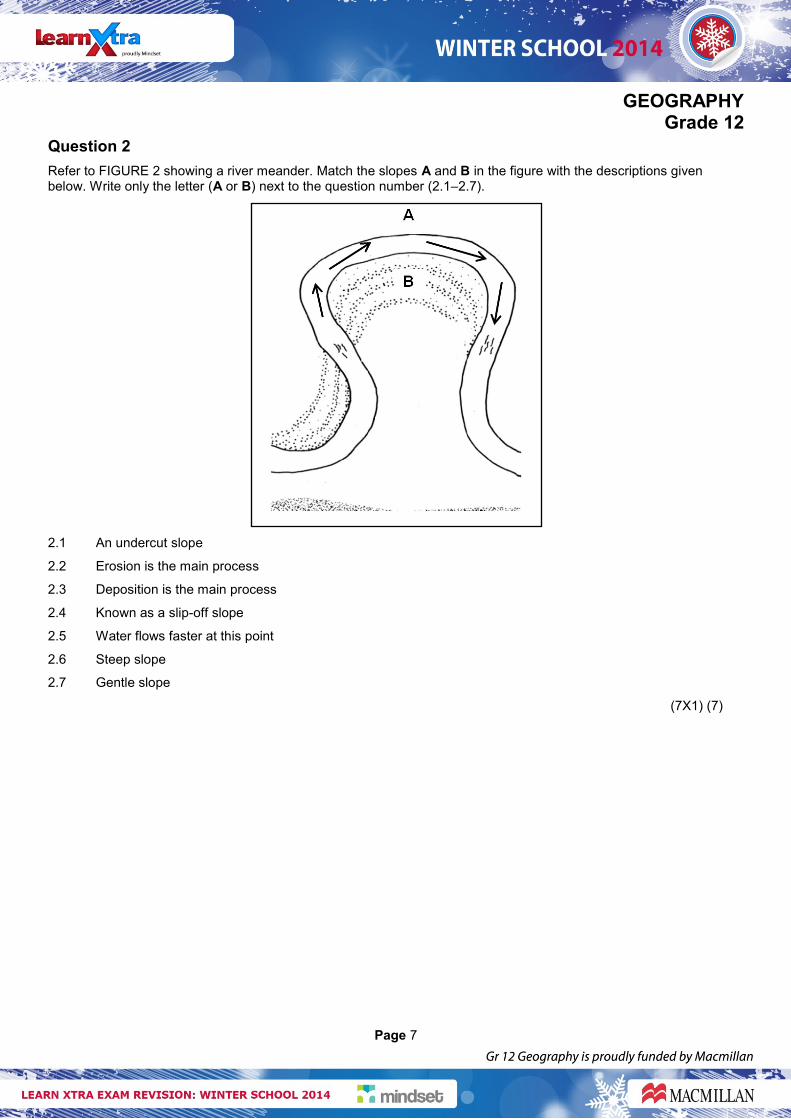
Question 2
Refer to FIGURE 2 showing a river meander. Match the slopes A and B in the figure with the descriptions given below. Write only the letter (A or B) next to the question number (2.1–2.7).
2.1 An undercut slope
2.2 Erosion is the main process
2.3 Deposition is the main process
2.4 Known as a slip-off slope
2.5 Water flows faster at this point
2.6 Steep slope
2.7 Gentle slope
(7X1) (7)
GEOGRAPHY Grade 12
Page 8
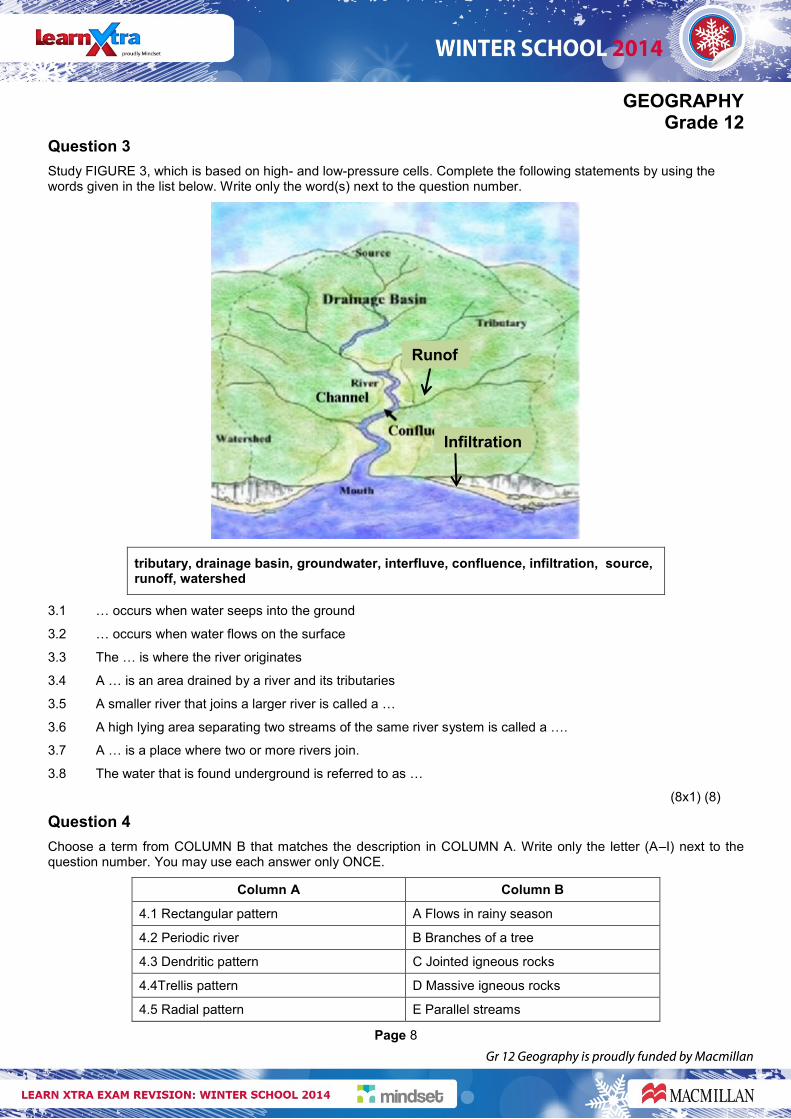
Question 3
Study FIGURE 3, which is based on high- and low-pressure cells. Complete the following statements by using the words given in the list below. Write only the word(s) next to the question number.
tributary, drainage basin, groundwater, interfluve, confluence, infiltration, source, runoff, watershed
3.1 … occurs when water seeps into the ground
3.2 … occurs when water flows on the surface
3.3 The … is where the river originates
3.4 A … is an area drained by a river and its tributaries
3.5 A smaller river that joins a larger river is called a …
3.6 A high lying area separating two streams of the same river system is called a ….
3.7 A … is a place where two or more rivers join.
3.8 The water that is found underground is referred to as …
(8x1) (8)
Question 4
Choose a term from COLUMN B that matches the description in COLUMN A. Write only the letter (A–I) next to the question number. You may use each answer only ONCE.
Column A Column B
4.1 Rectangular pattern A Flows in rainy season
4.2 Periodic river B Branches of a tree
4.3 Dendritic pattern C Jointed igneous rocks
4.4Trellis pattern D Massive igneous rocks
4.5 Radial pattern E Parallel streams
Infiltration
Runof
f
GEOGRAPHY Grade 12
Page 9
4.6 Episodic river F A river that has its water source in a wet area
4.7 Permanent river G Flows after heavy rainfall
4.8 Exotic river H Flows throughout the year
(8X1) (8)
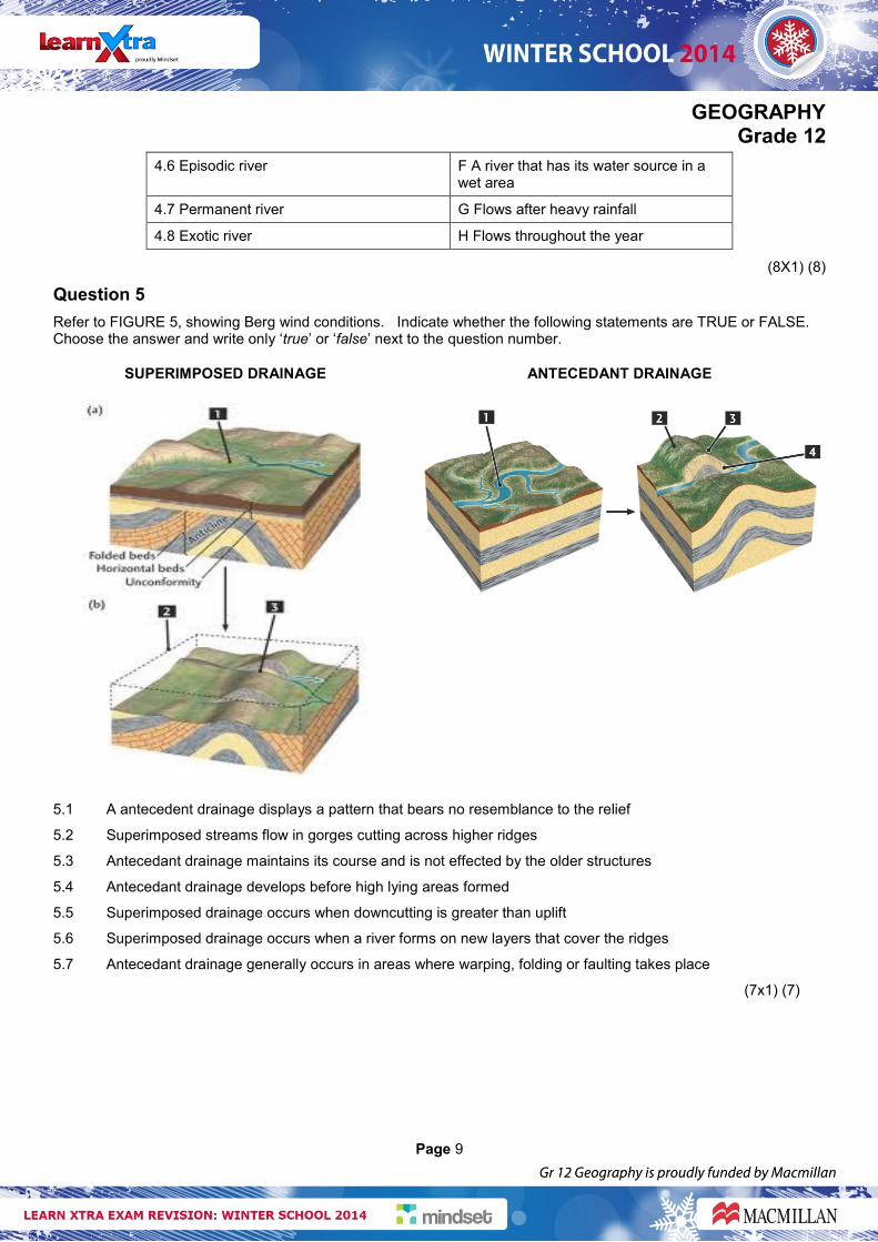
Question 5
Refer to FIGURE 5, showing Berg wind conditions. Indicate whether the following statements are TRUE or FALSE. Choose the answer and write only ‘true’ or ‘false’ next to the question number.
SUPERIMPOSED DRAINAGE ANTECEDANT DRAINAGE
5.1 A antecedent drainage displays a pattern that bears no resemblance to the relief
5.2 Superimposed streams flow in gorges cutting across higher ridges
5.3 Antecedant drainage maintains its course and is not effected by the older structures
5.4 Antecedant drainage develops before high lying areas formed
5.5 Superimposed drainage occurs when downcutting is greater than uplift
5.6 Superimposed drainage occurs when a river forms on new layers that cover the ridges
5.7 Antecedant drainage generally occurs in areas where warping, folding or faulting takes place
(7x1) (7)