geography - secretariat assistantsecretariatassistant.com/uploads/prelim_exam/... · geography is...
TRANSCRIPT

6 9 3
Origin of Geography The word 'geography' derives from the greek
words ‘geo’ (meaning 'the earth') and “graphia”(meaning 'to write'). Geography is the science thatdeals with the description of Earth’s surface.
Greeks were the first people of the western worldto study geography in a systematic way.
Basic Knowledge about theEarth The earth is believed to have originated some
4.6 billion years ago. Radio activity method (Uranium - Lead method)
D]-tbm-Kn¨v \S-¯nb ]co-£-W-amWv `qan-bpsS{]mbw Is-¯m³ klm-bn-¨-Xv.- a-\p-jy³ `qan-bn {]Xy-£-s¸-«n«v 5 e£w hÀj-§Ä Bb-Xmbn A\p-am-\n-¡p-¶p.
Specialists in GeographyCartographer: A cartographer specialisesin designing maps.Geologist : Scientists who study the earth’scrust to learn more about its structure, his-tory and composition.Geomorphologist : Geomorphologistsstudy the earth’s surface, the origin and dis-tribution of land forms, and the changes thatoccur on them.Hydrologist : Hydrologists study the physicaland chemical characteristics of water, its distri-bution and its circulation above and below theearth’s surface.Meteorologist : A meteorologist study theearth’s atmosphere and the variations in at-mospheric conditions that produce weather.Oceanographer : An oceanographer studythe ocean and the land beneath it.
Theories: The Origin of theEarth kqcy³ ̀ qan-bpsS ]nXmhv: _nÃy¬ hÀj-§Ä¡p-
ap¼v kqcy-\n-ep-mb kvt^mS-\-^-e-ambn Nn¶n-¨n-X-dnb ̀ mK-§Ä XWp-¯p-dªv ̀ qan-bpw aäp {Kl-§fpw cq]w-sImp F¶mWv ̀ qan-bpsS DÛ-h-s -̄¡p-dn-¨pÅ imkv{X-\n-K-a-\w.
Continental drift theoryContinential Drift Theory was put forward by the
Scientists inGeography
Luis Alvarez: who proposed in 1980that a large meteorite fell about 65 mil-lion years ago and wiped out the di-nosaurs and numerous other speciesfrom the earth.Alfred Wegner : The German scientistput forward the Continental DriftTheory.Erathosthenese: The Greek scholar,was the first to measure the circum-ference of the earth. He used the word'Geography' for the first time in thethird century B.C.Ferdinand Magellan : The Portuguesenavigator was the first to circumnavi-gate the world. He gave the name 'pa-cific' to the largest ocean in the world.
Charles F. Ritcher : TheAmerican seismologistdeveloped the magni-tude numbering systemin 1935 called RichterScale to measure themagnitude of earth-quake
Alfred Lothar Wegener(Berlin, November 1, 1880 –
Greenland, November 2 or 3, 1930)was a German interdisciplinary scientist
and meteorologist, who became famous forhis theory of continental drift.
GEOGRAPHY
6 9 4
German scientist Alfred Wegner in 1915. Accord-ing to the Continental Drift Theory, part of thecrust are capable of horizontal movement roundthe globe causing the continents to slowly changetheir positions in relation to one another.
The fact that South America is a mirror image ofAfrica is presented as a proof of the continentaldrift theory.
Plate Tectonics TheoryPlate tectonics theory was put forward byA.Holmes. According to this theory thelithosphere of earth is considered to be dividedinto lithospheric plates. Each plate is capable ofmoving over the asthenosphere carrying oceanicor continental crust alike. At plate boundariesmajor landforms are created.
Most theories about the origin of the earth as-sumes that it began in a gaseous state.
Life appeared on earth only when the earth cooledfrom its gaseous state to solid one.
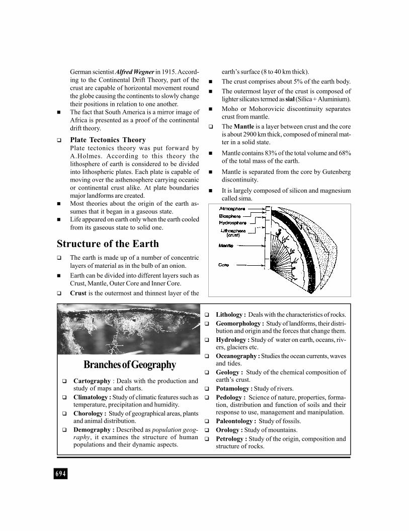
Structure of the Earth The earth is made up of a number of concentric
layers of material as in the bulb of an onion. Earth can be divided into different layers such as
Crust, Mantle, Outer Core and Inner Core. Crust is the outermost and thinnest layer of the
earth’s surface (8 to 40 km thick). The crust comprises about 5% of the earth body. The outermost layer of the crust is composed of
lighter silicates termed as sial (Silica + Aluminium). Moho or Mohorovicic discontinuity separates
crust from mantle. The Mantle is a layer between crust and the core
is about 2900 km thick, composed of mineral mat-ter in a solid state.
Mantle contains 83% of the total volume and 68%of the total mass of the earth.
Mantle is separated from the core by Gutenbergdiscontinuity.
It is largely composed of silicon and magnesiumcalled sima.
Branches of Geography Cartography : Deals with the production and
study of maps and charts. Climatology : Study of climatic features such as
temperature, precipitation and humidity. Chorology : Study of geographical areas, plants
and animal distribution. Demography : Described as population geog-
raphy, it examines the structure of humanpopulations and their dynamic aspects.
Lithology : Deals with the characteristics of rocks. Geomorphology : Study of landforms, their distri-
bution and origin and the forces that change them. Hydrology : Study of water on earth, oceans, riv-
ers, glaciers etc. Oceanography : Studies the ocean currents, waves
and tides. Geology : Study of the chemical composition of
earth’s crust. Potamology : Study of rivers. Pedology : Science of nature, properties, forma-
tion, distribution and function of soils and theirresponse to use, management and manipulation.
Paleontology : Study of fossils. Orology : Study of mountains. Petrology : Study of the origin, composition and
structure of rocks.
6 9 5
Asthenosphere is the upper part of the mantlewhich is about 250 km thick. The rocks containedin the asthenosphere are partially molten.
A Geyser is a fountain of hot water erupting fromthe hole of the earth’s surface which extends deepinto earth’s crust.
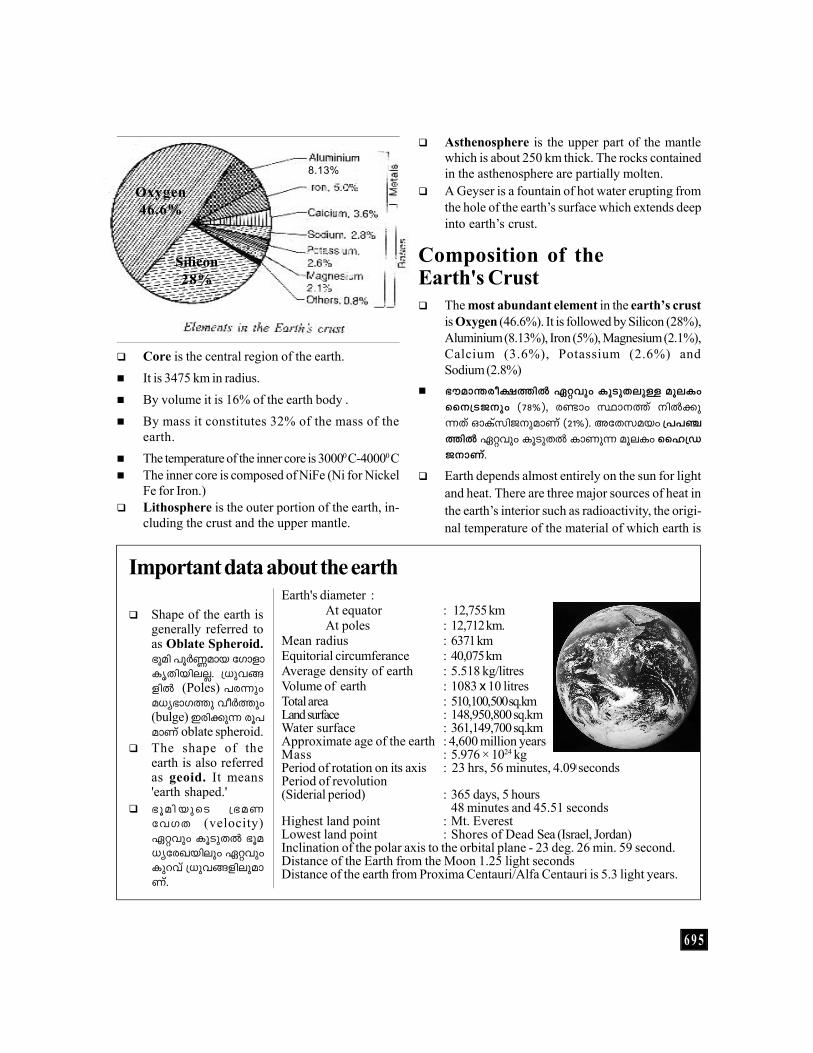
Composition of theEarth's Crust The most abundant element in the earth’s crust
is Oxygen (46.6%). It is followed by Silicon (28%),Aluminium (8.13%), Iron (5%), Magnesium (2.1%),Calcium (3.6%), Potassium (2.6%) andSodium (2.8%)
`uam-́ -co-£-̄ n Gähpw IqSp-X-epÅ aqeIwss\{S-P\pw (78%), cmw Øm\¯v \n¡p-¶Xv HmIvkn-P-\p-amWv (21%). AtX-k-abw {]]-©-¯n Gähpw IqSp-X ImWp¶ aqeIw ssl{U-P-\m-Wv.
Earth depends almost entirely on the sun for lightand heat. There are three major sources of heat inthe earth’s interior such as radioactivity, the origi-nal temperature of the material of which earth is
Shape of the earth isgenerally referred toas Oblate Spheroid.`qan ]qÀ®-amb tKmfm-Ir-Xn-bneÃ. {[ph-§-fn (Poles) ]c¶pwa[y-`m-K¯p hoÀ¯pw(bulge) Ccn-¡p¶ cq]-amWv oblate spheroid.
The shape of theearth is also referredas geoid. It means'earth shaped.'
`qan -bpsS {`aWthKX (velocity)Gähpw IqSp-XÂ `qa-[y-tc-J-bnepw GähpwIpdhv {[ph-§fnepam-Wv.
8.13%
Oxygen46.6%
Silicon28%
Important data about the earthEarth's diameter :
At equator : 12,755 km At poles : 12,712 km.
Mean radius : 6371 kmEquitorial circumferance : 40,075 kmAverage density of earth : 5.518 kg/litresVolume of earth : 1083 x 10 litresTotal area : 510,100,500 sq.kmLand surface : 148,950,800 sq.kmWater surface : 361,149,700 sq.kmApproximate age of the earth : 4,600 million yearsMass : 5.976 × 1024 kgPeriod of rotation on its axis : 23 hrs, 56 minutes, 4.09| secondsPeriod of revolution(Siderial period) : 365 days, 5 hours
48 minutes and 45.51 secondsHighest land point : Mt. EverestLowest land point : Shores of Dead Sea (Israel, Jordan)Inclination of the polar axis to the orbital plane - 23 deg. 26 min. 59 second.Distance of the Earth from the Moon 1.25 light secondsDistance of the earth from Proxima Centauri/Alfa Centauri is 5.3 light years.
Core is the central region of the earth. It is 3475 km in radius. By volume it is 16% of the earth body . By mass it constitutes 32% of the mass of the
earth. The temperature of the inner core is 30000 C-40000 C The inner core is composed of NiFe (Ni for Nickel
Fe for Iron.) Lithosphere is the outer portion of the earth, in-
cluding the crust and the upper mantle.
6 9 6
made and the heat of aggradation.
The ratio between the total amount of light reflectedfrom an object in space and the total amount of lightfalling on an object is called albedo.
A perfect reflector has an albedo of 1 and earthhas an albedo of 0.34 (34%).
Position, Shape and Size ofEarth Lying between the Venus and Mars, the earth is
the third planet of the solar system. It ranks fifthin size with a mean radius of 6371 kilometers.
The shape of the earth is oblate spheroid, ie, al-most spherical, but flattened a little at the poleswith a slight bulge at the centre (equator).
Earth moves around the sun in an elliptical orbit.The spinning (rotation) of the earth at a high speedhas caused its mass to bulge at the equator andsink in at the poles.
`qan-bpsS a²y-`mKw hoÀ¯n-cn-¡m³ ImcWwcetrifugal force BWv.
The plane passing through the Earth's orbit iscalled orbital plane. The Earth's axis is inclinedand makes an angle 66½0 with the orbital plane.
The difference between the equatorial diameter
(12,755 km) and the polar diameter (12, 712 km) ofearth is 43 km.
Motions of the Earth andtheir Consequences
The movement of earth can be mainly divided intotwo as, rotation and revolution.
Rotation is the spinning of earth on its own axis. Earth spins on its axis at an angle of 66½0 to the
plane of earth from west to east.
Earth’s rotation takes 23 hours, 56 minutes and4.091 seconds to complete one rotation.
Rotation results in the formation of day and night,changes in the direction of wind and ocean cur-rents. The twice daily occurence of tides is alsoresulted by the rotation of earth.
Day and night are not of equal duration through-out the year because of the tilt of earth’s axis.
Earth rotates 10 in 4 minutes. Therefore earth ro-tates 150 in one hour. It takes 24 hours (one day)to complete one rotation (3600).
Day and night are equal at the equator through-out the year, because the circle of illuminationalways divides the equator into two equal parts.
The duration of day and night at the poles is sixmonths each.
Rotation also causes coriolis forces (named after theFrench who first explained them mathematically)which are related to the decreasing rotational veloc-ity with increasing latitude and tend to deflect anybody which is moving over the earth’s surface.
Coriolis force is zero at the equator and increasesprogressively towards either poles.
Revolution is the movement of earth in its orbitaround the sun, along an almost circular path(elliptical) called its orbit. The earth revolvesapproximately one degree in one day. The speedof revolution of earth is 29 km/second.
Earth takes 365 days, 5 hours, 48 minutes and 45.51

6 9 7
When the light of the sun or the moon is ob-scured by another body, the sun or moon issaid to be in eclipse.
Eclipses are observed only when the sun is ator near a node and the moon is near the samenode.
Lunar eclipse is caused when the earth comesin between the sun and the moon and casts itshadow on the moon.
Lunar eclipse occurs only on a full moon day.However, it does not occur on every full moonday because the moon is not in the same posi-tion in relation to that of the earth and the sun,on every full moon day.
seconds for one revolution around the sun. It iscalled one solar year. Earth has to cover 938 millionkilometers along its elliptical orbit to complete onerevolution.
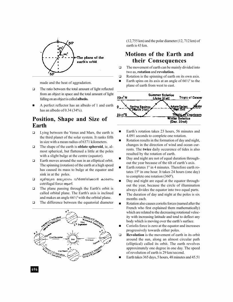
The earth’s revolution causes a change in seasons.Seasons are classified into four called the Spring,Summer, Autumn and Winter. The earth’s axis isinclined at an angle of 66 ½0 to the plane of its orbit.
Below given in a simplified diagram showing theannual movement of the sun and causes of theseasons.
Equinoxes are dates when the night and days areequal. During these days the sun shines verti-cally on the equator. This occurs twice a year.March 21 is called the vernal equinox or Springequinox and September 23 is called autumnal equi-nox.
Solstice is the time of the year when the differ-
ence between the length of days and the lengthof nights is the largest. During these days the sunshines vertically over the tropic.
On or around June 21 the North pole tilts to-wards the sun and the sun shines directly overthe tropic of cancer. This is called Summer Sol-stice. On or around December 22, the earth is atthe end of its orbit. The South pole tilts towardsthe sun and the North pole away from it, which iscalled as Winter Solstice.
Tropics are the regions circling the earth betweenthe Tropic of Cancer (230 27'N) and the Tropic ofCapricorn (230 27'S). These imaginary lines of lati-tude, mark the farthest points reached by the sun’svertical rays. The 23½0 North parallel is termed asTropic of Cancer and the 23½0 South parallel istermed as Tropic of Capricorn.
Sun rays fall vertically at the Tropic of Cancer onJune 21 and they fall vertically at the Tropic ofCapricorn on December 22.
Longest day (shortest night) in the northern hemi-sphere is June 21 and shortest day (longest night)is December 21. Longest day in the southern hemi-sphere is December 22 and shortest day is June 21.
Aphelion is the point in the earth’s or other plan-ets orbit which is farthest from the sun. Earth is atits aphelion on July 4 every year at a distance of152 million kilometers.
Perihelion is a point in the orbit of a planet or anyother celestial body at which it passes closest tothe sun. Earth will be at its per helion on January3 every year at a distance of 147 million kilome-
Eclipses
Solar eclipse occurs when the moon comes in be-tween the sun and earth. There is either a partial ortotal obstruction of sun’s light when viewed fromthe earth.
Solar eclipse occurs on a new moon day when themoon is in line with the sun. However due to theinclination of the moon’s orbit, a solar eclipse doesnot occur on every new moon day.
6 9 8
tres. Perigee is the point in the orbit of the moon at which
it is closest to the earth. Apogee is the point in theorbit of the moon at which it is farthest from the earth.
Climatic zones of the earth Equator is the biggest circle drawn on the globe. The regions between 5o north and 50 south of the
equator is called the Equatorial region. Here thetemperature is very high and rainfall is very heavy.
Torrid zone which is the hottest zone lies between23½0 North and 23½0 South. ie., between theTropic of Cancer and Tropic of Capricorn.
Temperate zone: Lies between 23½o north and66 ½o north North Temperate zone and South Tem-perate zone lies between 23½o south and 66½o
south. This zone has a marked annual range oftemperature.
Frigid zone lies between 66½0 north and 900N inthe case of north frigid zone and 66½o south and900 south in the case of south frigid zone. Theyare extremely cold regions.
Location of Place and Timeon the Earth's Surface Equator is an imaginary line passing round the
earth midway between the north and south poles,dividing the earth into two equal halves.
Latitude is the angular distance in degrees on theearth’s surface measured north and south of theequator. The latitude of any point on the earth ismost precisely expressed in degrees, minutes andseconds.
There are about 180 parallel latitudes. The distancebetween any two parallel latitudes is always equal.One degree of latitude is approximately equal to111 km.
A meridian is an imaginary line extending from thenorth pole to the south pole at right angles to theequator.
Prime Meridian is the 00 meridian which passesthrough Greenwich,a place near London. It is alsoknown as the Greenwich meridian.
Longtitudes are equi-distant lines drawn east andwest of the Greenwich meridian. They denote the
angular distances of a place due east or west ofthe Greenwich meridian. There are 360 meridiansof longtitudes.
One hour is equal to 150 of longtitude. Longtitude is an important factor in determining
the time in all parts of the world. Local time of aplace is calculated with respect to the mid dayposition of the sun at that place.
Local time varies from Greenwich time (London)at the rate of four minutes / degree of longtitude.
Standard time is the uniform time fixed by eachcountry.
Standard time in India is the local time of a placenear Allahabad at 82 ½oE longtitude.
Greenwich Mean Time is the standard time of U.K.It is based on the local time of the meridian pass-ing through Greenwich near London.
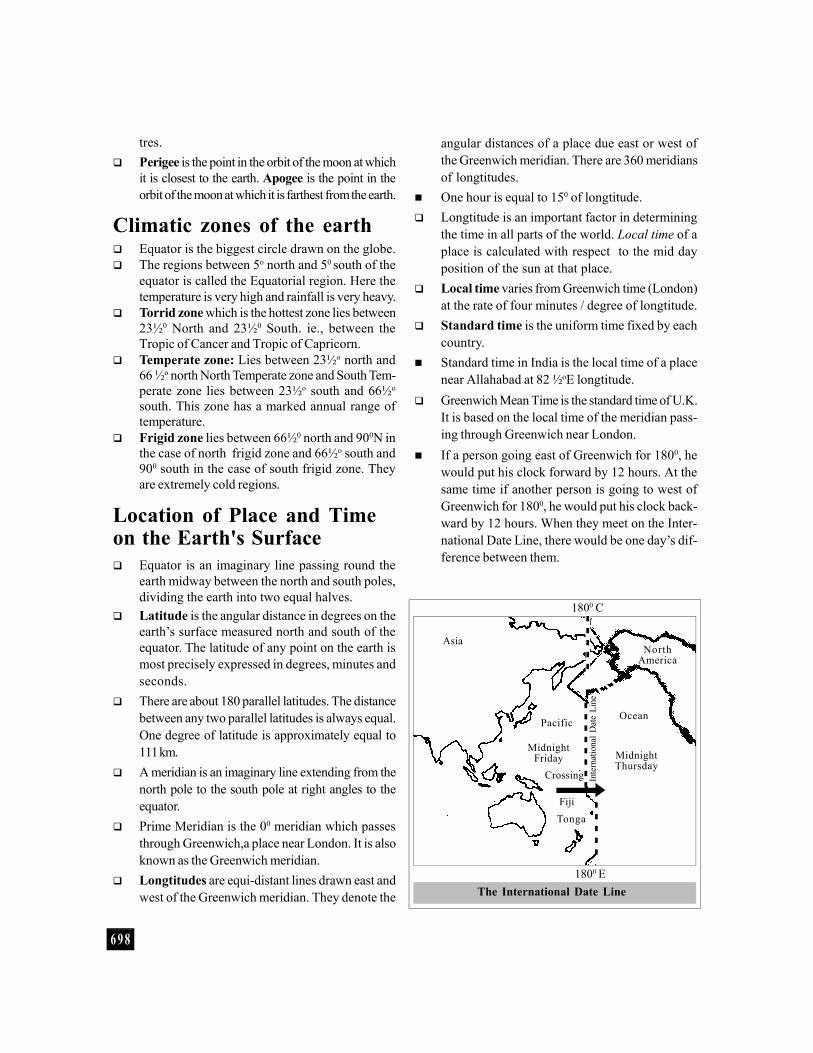
If a person going east of Greenwich for 1800, hewould put his clock forward by 12 hours. At thesame time if another person is going to west ofGreenwich for 1800, he would put his clock back-ward by 12 hours. When they meet on the Inter-national Date Line, there would be one day’s dif-ference between them.
The International Date Line
Asia
1800 C
Pacific
MidnightFriday
Crossing
FijiTonga
1800 E
Inte
rnat
iona
l Dat
e Li
ne
Ocean
MidnightThursday
NorthAmerica

6 9 9
The difference between the Greenwich time andIndian Standard Time is 5 ½ hours.
Earth is divided into 23 full time zones and twohalf time zones each having longtitudinal widthof 150 and 7½0 respectively.
The International Date Line is situated at 1800 me-ridian from Greenwich. It runs down the mid PacificOcean, veering to keep all of the islands in a group.
When one crosses the International Date Linefrom east to west the date is to be advanced byone day (loses one day). Similarly when onecrosses the Date Line from west to east, the dateis to be set back by one day (gains one day).
A ship while crossing the Date Line eastwards gainsa day, while it loses a day crossing westwards.
The local time of Arunachal Pradesh is two hoursahead of that of Gujarat because ArunachalPradesh is 300 east of Gujarat.
Russia, the largest country in the world, extends1650 from East to West. Therefore it is dividedinto eleven time zones, each differing in one hour.
The distance between any two meridians is notequal. They get closer from the equator to poles.
Since earth rotates 150 in one hour, there is a dif-ference of one hour in local time to every 150.
Siderial day is the time between two observedpassages of a star over the same meridian oflongtitude.
Sideral day = 23 hrs. 56 min. 4.09 seconds. Solar day is the time between two successive tran-
sits of the sun over the same meridian. Mean solar day = 24 hrs.
Rocks and Minerals Petrology is the study of the origin, composition
and structure of rocks, while Lithology is thestudy of the characteristics of rocks.
Rocks and minerals mainly constitute the upperpart of the earth’s crust. Minerals are natural sub-stances having characteristic properties and moreor less specific chemical compositions.
Rocks are solid materials that makes up the earth’scrust. On the basis of texture, structure and com-position, rocks may be classified into igneous,sedimentary and metamorphic.
Igneous rocks (B-tá-b-in-e-IÄ) are formed bythe solidification of molten magma from the inte-rior of the earth. About 95% of the earth’s crust ismade up of this type of rocks. They do not occurin layers. Most of them are crystalline.eg: Granite, Volcanic rocks and Basalt.
Sedimentary rocks (A-h-km-Z-in-e-IÄ) are formedfrom the sediments deposited on the ocean beds.They comprise only about 5% of the earth’s crust,but covers about 75% of the total land surface.eg: Sandstone, Limestone etc.
Shale is the most abundant of all sedimentary rockswhich is composed of silt and clay.
Sandstone is a common sedimentary rock whichis formed mainly of quartz particles cemented to-gether by silica, lime or iron oxide.
Metamorphic rocks (Imbm- -́cn-X-in-e-IÄ) areformed when pre-existing sedimentary or igne-ous rock is altered as a result of changes in physi-cal or chemical conditions.eg : Quartzite and Marble
The process which produces metamorphic rocksis called metamorphism.
Quartzite is the metamorphic form of the sedimen-tary rock, sandstone.
Two basic forms of tectonic activity that produceinitial landforms (folding and faulting)
7 0 0
Slate is formed by the compression of sedimen-tary rocks like shale and mudstone. Gneiss isformed by the metamorphosis of igneous rockslike granite.
Chalk is a calcareous rock made up of microscopicskeletal elements from a variety of lime secretingorganisms.
Coal and Peat represents the accumulation ofvegetation which originated in swamps. Peat is thefirst stage in the transformation of vegetable matterinto coal.
'Black Twins' is the name given to iron and coal.'Black lead' is graphite. Anthracite is the mostsuperior type of coal.
Movements of the Earth'sCrust As a result of the vertical and lateral movements
of the earth, major features such as mountains,plateaus and plains have been formed.
Warping and Isostasy constitute vertical move-ments, while folding, faulting and continental driftconstitutes horizontal movement.
Folding is the process whereby the rock strata arebent into a series of arches (anticlines) and troughs(synclines) as a result of the horizontal earth move-ments which cause compression with in the crust.
Fold mountains are formed by the crumbling orfolding of rocks.
The Himalayas, the Alps, the Andes, the Rockiesetc. are examples of fold mountains.
Faulting is the process by which the tensionalearth movements under the effect of considerablepressure creates a fracture in the earth’s crust.
Faulting gives rise to relief features such as block
mountains and rift valleys. Block mountains are formed by the lifting up of
land between faults or by the sinking of land out-side the faults. They are usually steep sidedeg: The Vosages.
A Rift valley is a long, relatively narrow depres-sion formed by the sinking of a block of land be-tween two or more or less parallel faults.eg: East African Rift Valley.
Warping is the deformation of earth’s crust whichaffects very large areas on the earth’s surface. Itresults in the formation of domes, shields and de-pressions.
Isostasy is a condition of gravitational balancebetween the crustal segments of differentthickness.
Continental drift refers to the horizontal move-ments of the continents on a vast scale.
The Himalayas, the Andes, the Rockies and theAlps are examples of young mountains. They cameinto being after the continental drift.
The Pyrenees (Europe), Appalachians (America)and the Aravallis (India) are examples of old moun-tains. They were formed in the pre-drift area.
The Rockies are North American mountain rangeswhile the Alps are European, the Andes belongsto South American range. Mt. Blanc is the high-est peak in the Alps.
The Aravallis is the oldest mountain range inIndia. The Himalayas are the youngest fold moun-tains in India. The Vindhyas separates SouthernIndia from Northern India.
Satpuras lies in between Narmada and Tapti andNarmada lies in between Vindhya and Satpura.
The southernmost tip of Western Ghats is called
Seismic waves are of three main types namely'P' waves (primary), ‘S’ waves (secondary orshake) and 'L' waves (surface or long).
Primary (P) waves : Waves of short wave-length and high frequency are longtitudinalwaves which travel not only through the solidcrust and mantle but also through the liquidpart of the earth's core.
Earthquake Waves Secondary (S) waves : Waves of short wave-
length and high frequency, are transverse waveswhich travel through all the solid parts of theearth but not the liquid part of the core.
Long (L) waves : Waves of long wavelength andlow frequency are confined to the skin of theearths crust by causing structural damages.
7 0 1
Cardamom Hills. Sahyadri and Nilgiri are parts ofthe Western Ghats. Western Ghats and EasternGhats meet at Nilgiri Hills.
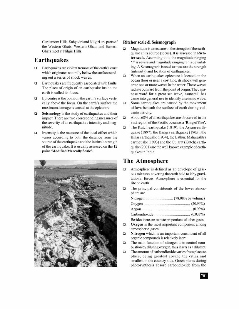
Earthquakes Earthquakes are violent tremors of the earth’s crust
which originates naturally below the surface send-ing out a series of shock waves.
Earthquakes are frequently associated with faults.The place of origin of an earthquake inside theearth is called its focus.
Epicentre is the point on the earth’s surface verti-cally above the focus. On the earth’s surface themaximum damage is caused at the epicentre.
Seismology is the study of earthquakes and theirimpact. There are two corresponding measures ofthe severity of an earthquake : intensity and mag-nitude.
Intensity is the measure of the local effect whichvaries according to both the distance from thesource of the earthquake and the intrinsic strengthof the earthquake. It is usually assessed on the 12point ‘Modified Mercally Scale’.
Ritcher scale & Seismograph Magnitude is a measure of the strength of the earth-
quake at its source (focus). It is assessed in Rich-ter scale. According to it, the magnitude ranging‘7’ is severe and magnitude ranging ‘8’ is devastat-ing. A Seismograph is used to measure the strength(intensity) and location of earthquakes.
When an earthquakes epicentre is located on theocean floor or near a cost line, its shock will gen-erate one or more waves in the water. These wavesradiate outward from the point of origin. The Japa-nese word for a great sea wave, 'tsunami', hascame into general use to identify a seismic wave.
Some earthquakes are caused by the movementof lava beneath the surface of earth during vol-canic activity.
About 68% of all earthquakes are obvserved in thevast region of the Pacific ocean as a 'Ring of fire'.
The Kutch earthquake (1819), the Assam earth-quake (1897), the Kangra earthquake (1905), theBihar earthquake (1934), the Lathur, Maharashtraearthquake (1993) and the Gujarat (Kutch) earth-quake (2001) are the well known example of earth-quakes in India.
The Atmosphere Atmosphere is defined as an envelope of gase-
ous mixtures covering the earth held to it by gravi-tational forces. Atmosphere is essential for thelife on earth.
The principal constituents of the lower atmos-phere areNitrogen ............................ (78.08% by volume)Oxygen ............................................... (20.94%)Argon ................................................... (0.93%)Carbondioxide .................................... (0.033%)Besides there are minute proportions of other gases.
Oxygen is the most important component amongatmospheric gases.
Nitrogen which is an important constituent of allorganic compounds is relatively inert.
The main function of nitrogen is to control com-bustion by diluting oxygen, thus it acts as a dilutant.
The amount of carbondioxide varies from place toplace, being greatest around the cities andsmallest in the country side. Green plants duringphotosynthesis absorb carbondioxide from the

7 0 2
atmosphere and use it to manufacture food andkeep other bio-physical processes going.
Ozone (O3) consisting of three oxygen atomschemically linked is another variable constituentof the atmosphere. In the lowest layers, the pro-portion of ozone is very low (less than 0.00005 byvolume of atmosphere).
Between 20km and 40 km altitude greater con-centrations of ozone are found. At levels above32 km, it increases forming what is known as theozone belt. It plays a crucial role in blocking theharmful ultraviolet radiation from the sun.
Water vapour is one of the most variable gaseoussubstances present in the atmosphere, consti-tuting between 0.02% and 4% of the totalvolume in cold dry and humid tropical climatesrespectively. 90% of moisture content in theatmosphere exists within 6km on the surfaceof earth.
Atmosphere also contains huge numbers of solidand liquid particles called aerosols. In addition,negligible quantities of other gases such as ar-gon, neon, helium, hydrogen, xenon, krypton,methane etc were present in the atmosphere.
Structure ofAtmosphere The earth’s atmosphere is made up of
a series of layers on the basis of thevertical distribution of temperatures.
Atmosphere can be classified intotroposphere, stratosphere,mesosphere, thermosphere(Ionosphere) and the exosphere.
Troposphere is the lowest layer of theatmosphere and extends roughly to aheight of 7 to 8 km near the poles tosome 16km over the equator. The thick-ness is greater at the equator, becausethe heated air rises to greater heights.
Stratosphere is a region of uniformtemperature extending from an altitudeof about 11km above the earth to aheight of nearly 50km. It is free fromwater vapour, clouds and dust.
The upper part of the stratosphere hasplenty of ozone which affords protec-tion to human beings on the earth
against the fatal effects of ultraviolet radiations. The Stratosphere also provides ideal conditions
for flying aeroplanes. The upper limit of this layeris called stratopause.
Mesosphere is a very cold region above thestratosphere which extends from 50 or 80km abovethe earth’s surface.
Within the mesosphere the temperature decreaseswith altitude from about 0oC at stratopause to about–100oC at mesopause. Mesopause is the bound-ary line between ionosphere and mesophere.
Thermosphere is the uppermost layer of the atmos-phere extending from the mesopause at an altitudeof about 85 kms to the outer limits of atmosphere.
Ionosphere is that part of the thermosphere whichextends above the mesosphere from 65 km tonearly 400 km above the earth’s surface. It is anelectrically charged layer characterised by the ioni-sation of atoms.
Due to the presence of electric charge in the Iono-sphere, radio waves transmitted from the earthare reflected back to the earth by this layer.
Exosphere is the uppermost region of the atmos-phere. It extends beyond the ionosphere above aheight of about 400km. The air is extremely rare-
7 0 3
fied and the temperature graduallyincreases through the layer. Herethe gravity of earth is exceedinglyweak.
The lowest temperature of air is re-corded just before sunrise, becauseof the predominance of land overwater in the north, the northernhemisphere is warmer.
The pressure exerted by atmos-phere as a result of its weight abovea unit area of the earth’s surface iscalled the atmospheric pressure.
Atmospheric pressure is expressedin millibars (mb) and is measuredwith a mercury barometer.
Two principal types of barometerused are mercury barometer and
fined as the movement of air caused by air risingor sinking.
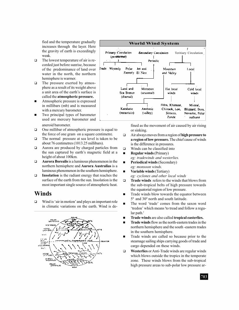
Air always moves from a region of high pressure toa region of low pressure. The chief cause of windsis the difference in pressures.
Winds can be classified into Regular winds (Primary)
eg: tradewinds and westerlies. Periodical winds (Secondary)
eg: monsoon winds. Variable winds (Tertiary)
eg: cyclones and other local winds Trade winds refers to the winds that blows from
the sub-tropical belts of high pressure towardsthe equatorial region of low pressure.
Trade winds blow towards the equator between50 and 300 north and south latitude.
The word ‘trade’ comes from the saxon word‘tredon’ which means 'to tread and follow a regu-lar path.'
Trade winds are also called tropical easterlies. Trade winds flow as the north-eastern trades in the
northern hemisphere and the south -eastern tradesin the southern hemisphere.
Trade winds are called so because prior to thesteamage sailing ships carrying goods of trade andcargo depended on these winds.
Westerlies or Anti-Trade winds are regular windswhich blows outside the tropics in the temperatezone. These winds blows from the sub-tropicalhigh pressure areas to sub-polar low pressure ar-
World Wind System
aneroid barometer. One millibar of atmospheric pressure is equal to
the force of one gram on a square centimetre. The normal pressure at sea level is taken to be
about 76 centimetres (1013.25 millibars). Aurora are produced by charged particles from
the sun captured by earth’s magnetic field at aheight of about 100km.
Aurora Borealis is a luminous phenomenon in thenorthern hemisphere and Aurora Australias is aluminous phenomenon in the southern hemisphere.
Insolation is the radiant energy that reaches thesurface of the earth from the sun. Insolation is themost important single source of atmospheric heat.
Winds Wind is ‘air in motion’ and plays an important role
in climatic variations on the earth. Wind is de-
Teritiary Circulation

7 0 4
Doldrums are equatorial belts of low pressurewhere the north-east and south-east trade windsconverge on and meet each other approximatelybetween 50 south and 50 north latitude. The belt ischaracterised by extremely low pressure with calmconditions.
Roaring Forties are powerful westerly winds thatblow throughout the year over the oceans of thesouthern hemisphere between 400 and 600 southlatitudes. They are called Best brave winds andbring storms and heavy rainfall.
The winds which developed between 450 and 550
are called Furious Fifties and that developed be-tween 550 and 650 are called Shrieking sixties.These are the dreaded terms used by sailors.
Local winds develop as a result of the local differ-ences in temperature and pressure. They affectthe smaller areas and are restricted to the lowestlevels of the troposphere.
Land Breeze (Night Time) Sea Breezes (Day Time)
eas and between 350 and 600 North and South lati-tudes.
Polar Easterlies constitute the wind system char-acteristic of the arctic and polar zones. They ex-tend from about 600 north and 600 south latitudeto the poles.
Monsoon winds are seasonal winds which blowbriefly over India, Sri Lanka, China and north-westAustralia.
Monsoon climate is marked by summer rains andwinter droughts.
Polar winds are winds which blow from the highpressure area around the poles towards the tem-perate regions.
Planetary winds are permanent winds which blowthroughout the year from one latitude to the other inresponse to the latitudinal differences in air pres-sure. They blow over the vast areas of continentsand oceans.
Horse Latitudes are sub-tropical belts of variablewinds and columns that lie between the latitudesof 250 and 350 North and South. They coincidewith the sub-tropical high pressure belts.
Horse Latitude winds are weak and shifting. Inearly days, the sailing vessels with a cargo ofhorses found it difficult to sail under such calmconditions. They used to throw horses into thesea to save valuable drinking water and this parttherefore came to be called as Horse Latitudes.
Wind Wane : Instrument for knowing thedirection of wind.
Anemometer : Measures the velocity of thewind.
Beaufort scale is an internationally acceptedwind scale which consists of a series ofnumber devised by Sir Francis Beaufort in1805 to indicate different wind strengths.
Instruments to Measure Wind
7 0 5
Local winds includes hot, cold, convectional andslope winds.
The most famous local cold winds that blow fromAlps over France towards the Mediterranean seais the mistral.
Loos are very hot and dry local winds that blows fromthe west in the months of May and June, usually inafternoons in the plains of Northern India andPakistan. Its temperature unvariably varies between450C and 500C. It may cause sunstroke to people.
Local convectional winds are of two types - Landbreeze and sea breeze.
Land breeze is defined as the process by whichcold winds blows from the land to sea during night.Land breeze is not as strong as the sea breeze.
During the day time, the land get warmer than thesea producing low pressure over the land intowhich cooler air moves from over the sea. Thelocal winds that blows from sea to land during theday time is called Sea breeze.
Valley breeze and mountain breeze are the coun-terparts of land and sea breeze. During the daytime the slopes of the mountain gets heated morethan the valley floor. As such the air from thevalley flows up the slope. This is called the Valleybreeze. After sunset the process is reversed. Rapidloss of heat through terrestrial radiation along themountain slopes results in the sliding of colddense air from higher elevations to valleys. This
is called the mountain breeze. Jet streams are narrow concentrated bands of
meandering high velocity geostrophic streamsbounded by low speed winds and is a part ofupper level westerlies.
The Jet streams have an average velocity of 120 km perhour in winter and 50km per hour in summer.
A gale is a strong wind having the speed be-tween 56 and 72 km per hour.
A storm refers to a strong wind whose speed ex-ceeds 72 to 121 km/hr.
A hurricane is a strong wind whose speed ex-ceeds 121 km/hr.
Cyclones are irregular wind movements involv-ing closed air circulation around a low pressurecentre. Cyclones are associated with destructiveand violent disturbances such as heavy squallsand torrential rainfall.
Cyclones are called hurricanes in the South-eastCarribean region.
In the Philippines islands, eastern China and Ja-pan cyclones are called Typhoons.
Around South-east African coast, Madagascar,Mauritius islands and North-west Australia theyare called Willie Willies.
If the speed of cyclone is greater than 250 km/hr itis known as Super Cyclone. 1999- Â Hdo-k-bnÂ\mi-\jvSw hnX-¨Xv Super Cyclone BWv.
Tornadoes are violently rotating storms, charac-
The days and years are based on solar (sun)time.
One day equals to the length of time it takes forthe earth to make one complete revolution inits own axis.
One year is the approximate time taken by theearth to make one complete revolution aroundthe sun.
The Sumerians, Babylonians and ancient Egyp-tians had calendars based on the lunar month.The original Roman calendar apparently cov-ers only agricultural months.
A calendar instituted in 1582 by Pope GregoryXIII has now been used in most of the world. Its
Years, Months & Calendarsdistinguishing feature is that in it a century year isa leap year.
Leap year is an year which is exactly divisibleby four. But the last year of a century will be aleap year only if it is exactly divisible by 400.Thus 1700, 1800, 1900 are not leap years but 1600,2000, 2400 etc are leap years. This correctionwas made by Pope Gregory XIII in AD 1582.
A year with 366 days is called a leap year. In aleap year February will have 29 days.
The concept of leap year was introduced in theRoman calendar by Julius Ceasar in46 BC, on the advice of his astronomer Sosigenes.
Britain introduced the Gregorian calendar in 1752.

7 0 6
Dew is the moisture deposited in the form of waterdroplets on the earth’s surface or on objects nearthe earth’s surface.
Dew point is the temperature at which air is fullysaturated and below which condensation normallyoccurs.
Condensation is the physical process of transfor-mation from the vapour to liquid state. Condensa-tion occurs when temperature reaches the dewpoint.
Frost is a weather condition that occurs when theair temperature is at or below 0oC. The moistureon the ground surface and objects, freezes to forman icy deposit.
Fog - Smog - Mist Fog is made up of droplets of water suspended in
the lower layers of atmosphere resulting from thecondensation of water vapour around nuclei offloating dust or smoke particles.
Smog also called smoke fog, is a form of fog thatoccurs in areas where the air contains a largeamount of smoke.
Mist is the term given for a reduction of visibil-ity between 1 - 2km caused by the condensation,producing water droplets within the lower layersof atmosphere. It is the intermediate between fogand haze.
Mist and fog are identical and are formed in thesame way. The only difference is that in a fog, theparticles of water are smaller and visibility is poorerthan in a mist.
Haze is formed by water particles that have con-densed around the nuclei in the atmosphere butmay also be a result of particles of smoke, dust orsalt in the air.
Clouds Clouds are a visible mass of small water drops or
ice crystals formed by the condensation of watervapour in the atmosphere, usually at a consider-able height above the earth’s surface.
Clouds are caused mainly by the adiabatic cool-ing of air below, its dew point.
On the basis of appearance, the clouds can beidentified as(i) Cirrus clouds are high, white & thin. They arecomposed of ice crystals. They form delicate
terised by a funnel shaped cloud in which windswhirl around a small area of extremely low pres-sure. They are generally accompanied by torren-tial rains.
Water Spout is a tornado occurring in the sea usu-ally in tropical and sub-tropical regions which con-nects a whirling cone of dense cloud with a cone ofspray raised from sea and thus raises a huge col-umn of water.
Anti–cyclone is a high pressure wind blowing out-wards from the centre, clockwise in the NorthernHemisphere and anti-clockwise in the SouthernHemisphere.
Coriolis force is a ‘fictious’ force needed to relatethe movement of air masses over the earth’s sur-face to its rotating co-ordinate system (the grid).It was named after the French mathematicianGaspard de Coriolis, who first described it in 1835.
The direction of action of the coriolis force isstated in Ferrel’s law. Ferrel’s law is a law postu-lated in 1856 by the American scientist WilliamFerrel who developed the concept of coriolis force.
Coriolis force is absent at the equator and in-creases towards the poles. The force is responsi-ble for the formation and direction of movementof anti-cyclones and whirlpools.
Climatic Conditions of Earth Weather is a condition of the atmosphere at a
certain place and time, with reference to tempera-ture and the presence of rain, sunshine, wind etc.
Climate is the regular pattern of weather condi-tions of a particular region.
Humidity is the degree of water vapour present inthe air. For any specified temperature, there is a defi-nite limit to the maximum quantity of moisture thatcan be held by the air. This limit is known as thesaturation point.
Humidity can be measured by means ofhygrometer.
Relative humidity is the ratio between the amountof water vapour actually present in an air massand the maximum amount that the air mass canhold at that temperature. It is expressed in termsof percentage.
7 0 7
patches and give a fibrous and feathery appear-ance.(ii) Cumulous clouds : have a flat base and havethe appearance of rising domes. These clouds areoften described as having cauliflower structure.(iii) Stratus clouds : as sheets of layer that coversmuch or all of the sky.
Alto and Nimbo are the two prefixes which referto middle level clouds and low clouds of consid-erable thickness with dark grey appearance re-spectively.For eg:- (1) Low clouds include stratocumulus,stratus, nimbostratus, cumulus and cumulonimbus. (2) Medium clouds include alto cumulusand alto stratus. (3) High clouds include cirrus,ciro stratus and cirro cumulus.
Precipitation is the formation of water particlesor ice within the cloud that falls towards the earth’ssurface. It occurs when condensation takes placerapidly with in the cloud.
Precipitation in the form of ice-pellets (hail stones)that develops in and fall from cumulonimbusclouds, either at a cold front or where intense heat-ing of the surface causes rapidly ascending con-vection currents called Hails.
Volcanoes A volcano is formed when the molten magma in the
earth’s interior escapes through the crust by ventsand fissures accompanied by steam gases (hydro-
gen sulphide, sulphur dioxide, hydrogen chloride,carbon dioxide etc) and pyroclastic materials.
Volcanic activity is an important process of con-struction on the earth’s surface.
Crater is a funnel shaped depression having acircular plan and a neck at the centre. Craters areformed by explosion or subsidence.
There are three types of volcanoes - active, dor-mant and extinct.
An active volcano erupts occasionallyeg: Mount Stromboli in Italy, Barren Islands inIndia (The only active volcano in India). Mt. Etnain Sicily and Cotopaxi in Equador.
Mt. Stromboli whose frequent eruptions that thesummit glow have earned, for it name 'Light houseof the Mediterranean.'
A dormant volcano has not been seen to erupt,but it shows evidence of recent activity.
Mt. Vesuvius and Mt. Krakatau are examples ofdormant volcano.
An extinct volcano shows no sign of life.Eg: Mt. Kilimanjaro
Fumaroles are fissures in the ground of volcanicareas through which gases including nitrogen, am-monia, carbon monoxide and methane are given off.
The Pacific belt is known as the Ring of fire be-cause of the largest number of active volcanoesare along the coasts of America and Asia on theocean.
Durand Line : Line of demarcation betweenthe boundaries of Pakistan and Afghanistandrawn by Sir Mortimer Durand.
Hindenberg line : The line of demarcation be-tween Germany and Poland.
Maginot Line : The line of fortification builtby France along its border with Germany.
Mannerheim Line : The line of fortificationbetween Russia and Finland.
Mc Mohan Line : It is the line of fortificationdrawn up by Sir Henry Mc Mahon, demarcatesthe frontier of India and China.
Oder - Neisse Line : It is the border line
Important Boundary Linesbetween Poland and Germany, running along theOder and Neisse rivers.
Radcliffe Line : Radcliffe line is drawn up by SirCyril Radcliffe which demarcates the boundaryof India and Pakistan.
Siegfried Line : It is the line of fortificationbetween Germany and France
17th Parallel : The 17th parallel defined theboundary between North Vietnam and SouthVietnam.
24th Parallel : It is the line which Pakistan claimsfor demarcation between India and Pakistan.
38th Parallel : It is the line of demarcation whichseparates North Korea from South Korea.
7 0 8
Batholiths are a large mass of magma which oftenforms the root of a mountain and is made up ofgranite.
Famous volcanoes of the world: Cotopaxi (Chile),Mt. Kilimanjaro (Tanzania), Mt. Etna (Italy),Mt. Vesuvius (Italy), Mt. Popa (Myanmar), MaunaLao, Mt. Kenya, Mt. Stromboli (Italy).
The volcanic islands of Hawai in the mid pacific,the famous hot water geycers of the yellow stoneregion of North America are exampled of inplatevolcanoes.
Surtsey, is an island born from a series of volcanicexplosions from deep within the earth's core cul-minated in the creation of a barren crest of rockthat jutted from the Atlantic Ocean.
Submarine TopographyTides Tide is the periodic rise and fall of sea water. The
tides are caused by gravitational pull of the moonand sun on earth’s sea water.
The time period between a high tide and a lowtide is approximately six hours. Each of them hap-pens twice a day.
Highest tidal amplitude and range was found inBay of Fundy.
Highest tides recorded in India is at Okha, Gujarat. Generally, tides occur twice a day. But in
Southampton, along the southern coast of Eng-land, experiences tides 4 times a day.
A rise in the water level is called high tide and afall is called low or ebb tide. Tides are of two types,Spring Tides and Neap Tides.
Spring Tides are caused as a result of the moonand sun pulling the earth gravitationally in thesame direction. They occur twice a month aroundthe full moon and new moon. It is the tide of maxi-mum rise.
Neap Tides are caused when the moon and thesun pull the earth gravitationally in oppositedirections. These tides are produced when themoon and the sun are at right angles to the earth.It is the tide of minimum rise, occuring twice amonth. They occur on half moon days.
Ocean Currents Ocean current is the movement of a sizeable body
of water as a current for fairly long distances alonga specific path.
Ocean currents are of two kinds:(i) Warm Currents (ii) Cold Currents
Warm currents which flows from a warmer re-gion to a colder region (equatorial to the polarregions).
Cold currents which flow from a colder to a warmerregion (polar region to the equatorial region).
Ocean currents are caused by several interactingforces. One of the prime causes, particularly ofsurface currents is wind.
Florida current and Brazil current are warm cur-rents of the Atlantic ocean;
Kurosiwo current is in the Pacific Ocean. Agulhas current is a major warm current of Indian
Ocean. Ocean currents change their direction annually in
the Indian Ocean. Labrador, Canaries, Benegueland Falkland are cold
currents of Atlantic Ocean. Alaska, Peruvian or Humboldt and California are
cold currents of the Pacific Ocean. Ocean currents influence the climate of the
regions they pass through. A wave is an undulation that moves across the
surface of the sea caused by the transfer of en-ergy from the wind to the sea.
Standing waves or stationary waves are causedby storm or sudden disturbances in water or at-mosphere.
Tidal waves or seismic waves or tsunamis are waveswhich are formed by underwater earthquakes involcanic eruptions at the sea bottom. They have along tidal period and a very high speed.
A canyon is a deep narrow valley with almostupright sides formed by the denudation of softrocks by rivers and rain water.eg : Grand canyon on the Colorado River in U.S.A
Coral reef is a ridge of rock in the sea that iscomposed chiefly of the skeletons of small ani-mals called reef - building coral polyps.
The most extensive of all the barrier reefs is theGreat Barrier Reef of Australia.
Atoll is a circular or horse–shoe shaped coral reefsurrounding a lagoon either having an island orsubmerged plateau in it. They are found chiefly in

7 0 9
the Pacific Ocean. Lagoon is a shallow stretch of water separated
completely or partly from the sea by a narrow stripof land.
Isthmus is a narrow strip of land joining two largerareas of land that would otherwise be separatedby water. The isthmus of Panama joins North andSouth America.
Strait is a narrow passage of water connectingtwo seas or two large areas of water.
A bay is a part of the sea or of a large lake en-closed by a wide curve of the shore.
Gulf is a part of the sea almost surrounded byland. Gulf streams are warm currents flowing acrossthe Atlantic Ocean from the gulf of Mexico to-wards Europe.
High seas are the open seas or oceans outsideany territorial waters of countries. They are alsoknown as International waters. ChnsS FÃm cmPy-
§Ä¡pw Xpey Ah-Im-i-am-Wp-Å-Xv.
kap-{Z-Xo-c-¯p-\n¶pw 12 t\m«n-¡Â ssa (22.22
In.-ao) Zqcw IS AXmXv cmPy-§Ä¡v A[n-Im-c-
ap-Å-Xm-Wv (territorial water). B cmPy-§-fpsS
A\p-hm-Z-an-ÃmsX aäp cmPy-§Ä¡v CXn-tebv¡v
{]th-in-¡m³ A-hImi-ap-m-hn-Ã. CXn-\p-]-cn-bmbn
Xoc-¯p-\n¶pw 200 t\m«n-¡Â ssa (370 In.-ao.)
AXmXv cmPy-§-fpsS kz´w km¼-¯n-I-ta-J-e-
bmbn (Exclusive Economic Zone) AwKo-I-cn- n̈-«p-v.
The laws binding the territorial right over the seahas been fixed by the UN and have been acceptedsince 1974. Within the Exclusive Economic Zone(EEZ) the coastal state has the right to exploit alleconomic resources - fish, minerals, oil and gasand energy production.
An estuary is the single v- shaped mouth of ariver when it merges into the sea. It is widest nearthe sea.
A delta is a triangular tract of alluvium, usuallyfan shaped at the mouth of a river where it depos-its more material than can be carried away. Theriver gets divided into two or more channels(distributaries), which may further divide and re-join to form a network of channels.
The world’s largest delta Sunderbans, is formedby the Ganges and the Brahmaputra in India andBangladesh. Its area is nearly 75,000 sq.km.
Beach is the shore of a sea, consisting of a stripof pebbles, sand or mud lying between low andhigh water marks.
Shoal is a shallow region in a sea, river or lake.
Waterbodies The Pacific ocean is the largest ocean, which cov-
ers an area of 166 million square kilometres andhas a volume of 696 million cubic kilometres.
The name 'Pacific' was given by FerdinandMagellan who was the first European to watchand cross it in 1521 to reach Philippines.
The Mariana Trench in Challenger Deep ofPacific Ocean is the deepest point on earth.
Atlantic ocean is the second largest ocean in theworld.
The greatest depth in Atlantic is Milwaukee depthin Puerto Rico Trench (8,648 m)
Atlantic is the busiest ocean route in the world.The Atlantic ocean separates American continentsfrom Europe and Africa.
Indian ocean is the third largest ocean in the world. The greatest depth in Indian ocean is the
Diamentina Trench. Madagascar is the biggest island in Indian ocean Bermuda Triangle is located in Atlantic Ocean. Arctic ocean is the smallest ocean in the world. The two most abundant elements in sea water are
I S-e nse G I -I -§ Ä Fathom: IS-ensâ Bgw Af-¡m\pÅ bqWnäv
One Fathom = 6 feet = 1.8 meters. Nautical Miles: IS-ense Zqcw Af-¡p-¶-Xn-
\pÅ GI-I-w.1 Nautical mile = 1.852 km1 mile = 1.6 km
IS¯oc-apÅ cmPy-§Ä¡v Xoc v̄ \n¶pw
12 Nautical Miles (22.22 In.-ao.) hsc-bpÅ kap-
{Z-̀ mKw Ah-cpsS Territory bpsS ̀ mK-am-Wv.
Xoc-¯p-\n¶pw 200 Nautical Miles (370In.-ao.) ISÂ `mKw Hmtcm cmPy-¯n-sâbpwkz´w km¼-¯nI taJe (ExclusiveEconomic Zone) IqSn-bm-Wv.
Knot: I¸-ep-I-fpsS thKX Af-¡m-\pÅbqWnäv.
One knot : 1.15 miles per hour
7 1 0
chlorine and sodium. Peninsula is a piece of land almost surrounded
by water. Southern India is a peninsula. The sea with the highest degree of salinity is the
Dead Sea. No fish live in this sea, hence it is calledDead Sea.
The Panama Canal links the Pacific Ocean withthe Atlantic Ocean.
The length of Panama Canal is 82 km (50 miles). Itwas built by the USA during 1904-14. Now thecontrol of the canal is with Panama. 1999 - -þÂ
CXnsâ \nb-{´Ww bp.-F-kv.-F. ]\m-abv¡v
ssIam-dn.
The Suez Canal links the Mediterranean Sea withthe Red Sea. The canal was nationalised byCol. Nasser on July 26, 1956.
Suez Canal is the artificial water way from PortSaid to Suez. It is 169 km long (100 mile). It sepa-rates Asia from Africa. It was opened in 1869 andnationalised in 1956.
Ferdinand de Lesseps, the French architect de-signed it.
Kiel canal, an international canal linking the NorthSea with the Baltic sea was built by the Germansin the years beore first world war. It is 96 km long.It was declared an international waterway by theTreaty of Versailles in 1919.
Berring Strait connects the Pacific Ocean andthe Arctic Ocean in the north, which separatesAsia and North America. The International DateLine passes through the Berring Strait.
Baffin Bay lies in between Greenland and Canada. The Grand Banks are the famous fishing grounds
in the North-West Atlantic. A waterfall is simply the fall of an enormous vol-
ume of water from a great height. Jog or GersoppaFalls on Sharavati (a tributary of Cauvery) inKarnataka is the highest waterfall in India.
A glacier (lnam-\n) is a moving mass of ice at aspeed averaging between 30 to 40 cm and 15 to 18metres per day. It originates at high altitudes dueto low temperatures and high orographic precipi-tation.
Rivers The Nile (6670 km) which is the longest river in
the world drains into the Mediterranean Sea. The Amazon, flowing into the South Atlantic, is the
largest river in terms of size and volume of water dis-charged. It is 6437 km long. It makes the largest riverbasin in the world covering an area of 7,045,000 sq.km.
The longest river in Europe is the Volga, 3690km. The longest river of Oceania is the Murray in
Australia (3220km). The Indus (2900km) is the longest river of the In-
dian subcontinent. The longest river of India isthe Ganges (2640km).
The Brahmaputra (2688km) is bigger than theGanges; but only a small part of it flows throughIndia. It originates from Manasarovar Lake in Ti-bet. In Tibet its name is Tsangpo.
The only river that crosses the equator twice isriver Zaire.
Victoria falls are in river Zambezi. The only river to cross the Tropic of Capricon
twice is river Limpopo in South Africa. City at the confluence of Blue and White Nile is
Khartoum, capital of Sudan. Longest river of Asia ..... Yangtze (Chang Jiang) Longest river of Europe ............................ Volga Longest river of North America ... Missisipi-Missouri Longest river of South America ............ Amazon Longest river of Australia ........ Murray Darling Longest river of Africa ............................... Nile Longest river of South East Asia ........ Mekong Longest river of South West Asia ..... Euphrates Longest river of Russia ..................... Ob-Irtysh Longest river of Sri Lanka...... Mahaweli Ganga The river which forms the boundary between
Russia and China is Amur. World's longest rivers in descending order of
length are Nile, Amazon, Chang Jiang andMissisipi-Missouri.
7 1 1
Lakes Lake Superior (82,400 sq.km in North America) is
the largest freshwater lake in the world. The Caspian Sea (3,72,000 sq.km) is the largest
salt water lake. It borders with Russia, Kazakhistan,Azerbaijan, Iran and Turkmenistan.
Lake Baikal (Russia) is the deepest freshwater lake(depth 1620 metres). It contains more water thanany other freshwater lake.
The highest navigable lake in the world is LakeTiticaca in Peru and Bolivia. It is 209 km long and3811 metres above sea level.
The saltiest lake in the world : Lake Van (Turkey) The largest lake of S.E. Asia : Lake Tonle sap. Largest lake of Australia - Lake Eyre. Great lakes arranged from west to east are Lake
Superior, Lake Michigan, Lake Huron, Lake Erie,Lake Ontario.
Great lake lying entirely in USA is LakeMichigan.
Lake Victoria, the largest lake in Africa is the sourceof White Nile, while Lake Tana in Ethiopia is thesource of Blue Nile.
Natural Vegetation Natural vegetation refers to a plant community
that has been left undisturbed over long time. Flora denotes the plants of a particular country or
region. Fauna denotes the animal kingdom found in a par-
ticular geographical region.World Forestry Day : March 21.
The world climate types have been classified onthe world's climatic / temperate zones.
The major climatic types of the world have beenclassified as(i) Equatorial(ii) Tropical Monsoon(iii) Tropical Desert(iv) Mediterranean type(v) Cool Temperate (Continental or Ocean)
Teak is the most valuable timber, which is used forfurniture making and is found in tropical monsoonclimate.
Savannah is a region which lies on both sides ofthe equator roughly between 5 degrees and thetropics. Here summers are hot and moist and win-ters are warm and dry. Characteristic vegetation istall grass.
Deciduous forests are forests with trees whichshed their leaves seasonally.
Tundras is the belt of treeless, cold desert which
Prairies ............................................ N. AmericaSteppes ................................................ EurasiaPampas ............................................ S.AmericaDowns ............................................... AustraliaVeldt ....................................... Southern Africa
Wellknown Grasslands
Name LocationTen Degree Channel : Little Andaman and
NicobarDuncan passage : South Andaman and Lit-
tle AndamanCape of Good Hope : Located at the southern
tip of African continent.Cape of Horn : Located at the southern
tip of South America.Strait of Malaca : Between Malaysia and
Sumatra
Important StraitsName Location
Barents Strait : Between Scandinaviancountries and Arctic Ocean.
Palk Strait : Between India and Sri LankaEnglish Channel : Between England and
FranceBerring Strait : Russia and the USAFlorida Strait : Cuba and USAStrait of Gibralter : Spain and MoroccoStrait of Magellan : Tip of South AmericaBass strait : Separates Australia from
Tasmania
7 1 2
remains under heavy snow during most of theyear. Eskimos live there. Igloos are dome shapedhuts of Eskimos which are dug half undergroundand covered with block of ice. Eskimos are alsocalled Inuits.
Natural resources are classified into biotic andabiotic resources.
Biotic resources are renewable resources con-sisting of living things such as forests and theirproducts, agricultural crops, fodders, wild and do-mestic animals etc.
Abiotic resources consists of non-living thingslike minerals and fuels which are mostly non-re-newable.
Reserved forests are forests reserved for com-mercial exploita-tion.
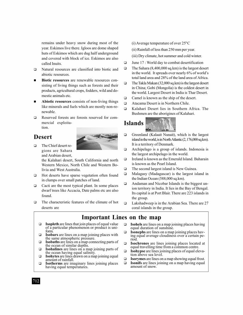
Desert The Chief desert re-
gions are Saharaand Arabian desert,the Kalahari desert, South California and northWestern Mexico, North Chile and Western Bo-livia and West Australia.
Hot deserts have sparse vegetation often foundin clumps over small patches of land.
Cacti are the most typical plant. In some placesdwarf trees like Accacia, Date palms etc are alsofound.
The characteristic features of the climate of hotdeserts are
Isopleth are lines that join places of equal valueof a particular phenomenon or product is uni-form.
Isobars are lines on a map joining places withthe same atmospheric pressure.
Isobaths are lines on a map connecting parts ofthe ocean of similar depths.
Isohalines are lines on a map joining parts ofthe ocean having equal salinity.
Isohytes are lines drawn on a map joining equalamount of rainfall.
Isotherms are imaginary lines joining placeshaving equal temperatures.
Important Lines on the map Isohels are lines on a map joining places having
equal duration of sunshine. Isonephs are lines on a map joining places hav-
ing equal average cloudiness over a certain pe-riod.
Isochrones are lines joining places located atequal travelling time from a common centre.
Isohypse are lines joining places of equal eleva-tion above sea level.
Isorymes are lines on a map showing equal frost. Isonifs are lines joining on a map having equal
amount of snow.
(i) Average temperature of over 250 C(ii) Rainfall of less than 250 mm per year.(iii) Dry climate, hot summer and cold winter.
June 17 : World day to combat desertification The Sahara (8,400,000 sq.km) is the largest desert
in the world. It spreads over nearly 6% of world’stotal land area and 28% of the land area of Africa.
The Takla Makan (32,000 sq.km) is the largest desertin China; Gobi (Mongolia) is the coldest desert inthe world. Largest Desert in India is Thar Desert.
Camel is known as the ship of the desert. Atacama Desert is in Northern Chile. Kalahari Desert lies in Southern Africa. The
Bushmen are the aborigines of Kalahari.
Islands
Greenland (Kalaait Nunait), which is the largestisland in the world, is in North Atlantic (2, 176,000 sq.km).It is a territory of Denmark.
Archipelago is a group of islands. Indonesia isthe largest archipelago in the world.
Ireland is known as the Emerald Island. Baharainis known as the Pearl Island.
The second largest island is New Guinea. Malagasy (Madagascar) is the largest island in
the Indian Ocean (588,000 sq.km). Andaman and Nicobar Islands is the biggest un-
ion territory in India. It lies in the Bay of Bengal.Its capital is at Port Blair. There are 223 islands inthe group.
Lakshadweep is in the Arabian Sea. There are 27coral islands in the group.