geologic map of the island of hawaii …. department of the interior u.s. geological survey to...
TRANSCRIPT

U.S. DEPARTMENT OF THE INTERIOR
U.S. GEOLOGICAL SURVEY
TO ACCOMPANY MAP I-2524-A
GEOLOGIC MAP OF THE ISLAND OF HAWAII
Compiled by Edward W. Wolfe and Jean Morris
INTRODUCTION
This is the first map of the entire Island of Hawaii to show in detail the age and distribution of both prehistoric cmd historic lavas. Its chronologie detail reflects the application of isotopic-dating techniques that were unavailable when its predecessor, the classic geologic map of Stearns and Macdonald (1946), was prepared. The recent geologic mapping has greatly refined our understanding of the geology and evolution of the Island of Hawaii. Nevertheless, the major elements of the stratigraphy and distribution of rock units established by Stearns and Macdonald still largely stand, testifying to the extraordinary geologic insight and mapping skill of those pioneering Hawaiian geologists. Others made important geologic mapping contributions in the 1960's and 1970's. Geologic maps were published for the Kilauea Crater quadrangle (Peterson, 1967), Kau Desert quadrangle (Walker, 1967), Mauna Loa quadrangle (Macdonald, 1971), middle part of the east rift zone of Kilauea (Moore and Koyanagi, 1969), and upper flanks and summit of Mauna Kea (Porter, 1979a); theses that include geologic mapping were completed for the Kawaihae quadrangle (Malinowski, 1977) and the northwestern part of Kohala (Giza, 1979). Our current work rests upon the solid geologic foundation laid by all of these previous workers.
GROWTH OF THE ISLAND AND EVOLUTION OF HAWAIIAN VOLCANOES
The subaerial part of the Island of Hawaii is composed of eruptive products from five distinct volcanoes. Each began to grow below sea level, then emerged from the sea and continued to grow, and ultimately joined its neighbors to form a single island. The loci of volcanism shifted progressively southeastward, which reflects the continuing northwestward motion of the Pacific Plate over the Hawaiian hot spot (Clague and Dalrymple, 1987). Thus, Kohala was the first of the five volcanoes to emerge from the sea, and Kilauea was the last. Eruptive activity has ceased at Kohala, and the most intense activity is now centered at the two southernmost volcanoes, Mauna Loa and Kilauea. The next volcano in the Hawaiian Chain. Loihi, is now growing beneath sea level on Hawaii's southeast flank {fig. 1).
Evidence from volcanoes of differing ages suggests that an idealized Hawaiian volcano evolves through a sequence of four eruptive stages-preshield, shield, postshield, and rejuvenated stages (Clague and Dalrymple, 1987, 1989}--distinguished by lava composition, eruptive
1
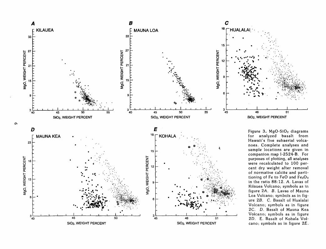
rate and style, and stage of development. No preshield lavas are exposed on Hawaii. Kilauea and Mauna Loa are vigorously active shield-stage volcanoes; their lavas consist, with rare exception, of tholeiitic basalt (figs. 2 and 3), which is characterized by a relatively low concentration of alkalis (Na20 and KzO) and, compared to postshield-stage basalt, a relatively high concentration of silica (Si02). Hualalai, Mauna Kea, and Kohala are all capped by postshield lavas, which are more alkalic than the shield-stage basalt. Among these three postshield volcanoes, shield-stage lavas crop out only on Kohala, where they are the oldest exposed rocks. The rejuvenated stage, in which small amounts of silica-poor lava erupt, occurs after as much as a few million years of volcanic quiescence; no volcanoes of the Island of Hawaii have reached this stage.
In an alternate approach, Moore and Clague (1992) defined the end of the shield stage as the time when upward growth of the volcano's surface at the shoreline is no longer rapid enough to keep pace with the subsidence that records isostatic adjustment of the growing volcanic mass (Moore, 1987). At that time, the continuing subsidence begins progressively to submerge the break in slope that had been previously maintained at the shoreline of the active shield volcano. By this criterion, Kohala ceased voluminous eruptions at about 245 thousand years ago (ka), and Mauna Kea and Hualalai each ceased voluminous eruptions at about 130 ka, on the basis of subsidence rates estimated from submergence of dated coral-reef deposits (Moore and Clague, 1992). As Moore and Clague note and we show below, these ages for the time of transition from voluminous to less voluminous eruptions on Mauna Kea and Kohala Volcanoes are appreciably younger than the age of the transition from tholeiitic to alkalic volcanism determined by K-Ar dating of subaerial lava flows. The following discussion uses the compositional criterion of Clague and Dalrymple to differentiate shield and postshield stages.
Analysis of eruption rates and comparison of lava compositions with experimental data suggest that the evolutionary stages reflect evolving rates of magma generation and changing degree of magma extraction from partially melted mantle source rocks: preshield stage, low rate of magma generation and low degree of partial melting; shield stage, high rate of magma generation and high degree of partial melting; and postshield stage, diminished rate of magma production and low degree of partial melting (Clague, 1987). Thus, the volcanic stage may reflect variation in the rate and amount of heat input to the lithosphere beneath each volcano as its part of the Pacific Plate approaches, passes over, and moves beyond the hot spot.

Keahole Point
... -=.e-.:.::
MAUNA KEA
MAUNA LOA KULANI --
25 KILOMETERS
EXPlANATION
Fault * Crest of lava shield
Generalized distribution 0 Caldera or crater of eruptive vents in identified in text rift zones of Kilauea ' Pyroclastic cones or and Mauna Loa prominent ridge
Figure 1. Map showing the five subaerial volcanoes (Kohala, Hualalai, Mauna Kea, Mauna Loa, and Kilauea) that form the Island of Hawaii and submarine Loihi Volcano forming on Hawaii's southeast flank.
2
PRESHIELD-ST AGE VOLCANISM
During the preshield stage, eruptions of alkalic basalt slowly build an initial, relatively small edifice on the sea floor. Loihi provides the only observed representative of a Hawaiian volcano in the preshield stage; any preshield lavas of other Hawaiian volcanoes have been buried by younger lavas. Compositional range from alkalic basalt to tholeiite of samples dredged from Loihi has been interpreted as evidence that Loihi is in transition from the preshield stage to the shield stage (Moore and others, 1982). The duration of preshield volcanism may be on the order of 100,000 years (Moore and Clague, 1992).
SHIELD-STAGE VOLCANISM
The most rapid and voluminous volcano growth, representing an estimated 95 to 98 percent of a volcano's ultimate volume, occurs during the shield stage-so-called because repeated eruption of fluid tholeiitic basalt, primarily from fissure vents along the crest of the volcano, builds a broad, smooth, gently sloping edifice resembling a warrior's shield in profile. Average shield-stage lava-accumulation rates are relatively high. The record of Kilauea's historic lava volumes (Peterson and Moore, 1987), augmented by extrapolation to 1990 of more recent accumulation rates in the east rift zone (Wolfe and others, 1987), indicates an average accumulation rate of 0.02 km3/yr from 1790 to 1990. This value is a minimum rate of growth for Kilauea during that period; it is clearly less than the magma supply rate, for it omits lavas of any submarine eruptions and volumes of magma intruded into the volcano but not erupted. Lockwood and Lipman (1987) reported an average accumulation rate for Mauna Loa of 0.03 km3/yr from 1843 through 1984.
The duration of the shield stage has never been measured. The oldest rocks of the shield stage are not exposed on any Hawaiian volcano, either above or below sea level. They form underwater, subside to even greater depths, and are largely if not completely buried by younger lavas. A typical duration for the shield stage of a Hawaiian volcano might be 500,000 years (Moore and Clague, 1992).
During the shield stage, lava erupts primarily from the summit of the volcano or from vents aligned along rift zones extending outward from the summit. The rift zones are marked by open fissure vents, open cracks, and small normal faults that testify to the intrusion of dikes along the rift-zone axis. Repeated eruptions in the summit and rift zones gradually build a massive shield, highest at the summit and elongated parallel to the rift zones. At Mauna Loa, numerous linear eruptive fissures on the volcano's northwest flank are oblique to the rift zones and radial to the summit.
Shield-stage activity is strongly influenced by the continuing supply of magma to a persistent shallow reservoir located approximately 3 to 7 km beneath the summit of the volcano (Decker, 1987). Geophysical observations at Kilauea (Tilling and Dvorak, 1993) show that pressure from continued accumulation of magma in the summit reservoir is relieved either by eruptions
3
in the summit area or by transfer of magma through conduits into one of the rift zones, where it may be either stored or erupted. Petrologic evidence of prolonged magma storage in Kilauea's rift zones is derived from recognition that some rift-zone eruptions produce lava from magma that has undergone appreciable compositional change because of cooling, partial crystallization, and mechanical separation of crystals during storage in shallow reservoirs (Wright and Fiske, 1971).
Seismic and geodetic data show that pressure builds $imilarly in Mauna Loa's summit reservoir (Decker and others, 1983) and is relieved by eruptions in the summit or rift zones (Lockwood and others, 1985). However, there is no geophysical evidence for extended storage of magma in Mauna Loa's rift zones, and, as Rhodes (1988) indicated for historic Mauna Loa lavas, samples recording extensive fractionation in shallow reservoirs are extremely rare.
Gravity strongly influences the growth, development, and structural failure of shield volcanoes. Magma rises into them and erupts because it is less dense than the enclosing rocks; the magma's buoyant ascent occurs in response to gravity. The orientations of the rift zones are controlled by gravitationally directed stresses on the volcanic edifice. Dikes, which mark the pathways along which magma is intruded into the rift zones and reaches the ground surface, are preferentially oriented perpendicular to the direction of least compressive stress (Fiske and Jackson, 1972). Thus, Kilauea's rift zones and their eruptive fissures are approximately parallel to the unsupported seaward side of the volcano and to the boundary between Kilauea and Mauna Loa.
Gravitational failure of the unsupported (seaward-facing) flanks of growing shield-stage volcanoes is recorded by voluminous submarine landslide deposits on the sea floor adjacent to most of the Hawaiian islands (Moore and others, 1989). Many of the faults mapped on the Island of Hawaii are normal faults interpreted to be related in origin to the massive flank failures. For example, Moore and others (1989) interpret normal faults along the crest and upper slopes of Kohala Volcano as boundaries of a pull-apart graben formed by structural adjustment to a huge, late shield-stage landslide from the volcano's northeast flank. The embayment of the volcano's northeast coast, between Kukuihaele and Akoakoa Point, marks the approximate upper headwall of the landslide, modified by subsequent coastal erosion. The deep valleys of the volcano's northeast flank, such as Pololu and Waipio Valleys, mark the heads of canyons incised by subaerial erosion of the landslide headwall before continuing subsidence of the island dragged it below sea level.
Westward-facing fault scarps at Kealakekua Bay and on Mauna Loa's southern cape are interpreted as remnants of the breakaway zone for a massive submarine landslide complex that originated on Mauna Loa's west flank prior to approximately 100 ka (Upman and others, 1990). A zone of normal faults on Mauna Loa's southeast flank, the Kaoiki-Honuapo Fault System, extends about 50 km northeastward from the Waiohinu area. These faults, largely draped by younger lava flows and ash deposits, are thought to reflect structural dislocations

.... z w ~
A 16
~ 12
~ (!)
w ?: ~ ...,: 8 z w .... z 8 0 ~ 4 + ~ IU z
.... z w
~
D 16
~ 12
~ (!) iii ?: ~ ...,: 8 z ~ z 0 0
~ 4 + ~ IU z
KILAUEA
/
0//.· . ......-: .. ,, /~:~ / . ·, . " .. . ~
• • .• .; BASALTIC BASALT ANDESITE ANDESITE
45 50 55 60
Si(h CONTENT, IN WEIGHT PERCENT
MAUNAKEA
o~------~------~~~--~--~--~--~ 40 45 50 55 60
SI02 CONTENT, IN WEIGHT PERCENT
!z w 0 a:
16
~ 12
!i: Cl w ;: ~ ...,: 8 z ~ z 0 0
~ 4 +
~ z
B
E
tz w 0 a:
16
~ 12 t-J: (!)
w 3: ~ ...,: 8 z ~ z 8 ~ 4 + 0 ~ z
MAUNALOA
Si02 CONTENT, IN WEIGHT PERCENT
KOHALA
45 50 55 60
Si02 CONTENT, IN WEIGHT PERCENT
16
!z w ~ ~ 12
~ Cl iii ?: ~ ...,: 8 z ~ z 0 0
~ 4 + 0 ~ z
c HUALALAI
0~------~------~~----L-~----~--~ 40 45 50 55 60
Si02 CONTENT, IN WEIGHT PERCENT
F KOHALA
!z w 0 a:
5
~ 4 tJ: (!)
iii 3: ~
~ ~ z 0 0
3
~ 2 + 0
Cl.l IU z
--------------~--------------, /
/ /
.,/
. .. . ...... ....... . : . / .· ... ":. ............ ~I • / . . / . / ..... r' . . ~ :. : ,.. ........ . . /• . .. / . . ...... <'.. •
/ . .~
. . ;/ ..
1 ~--~----~--~----~--~----L----L--~ 45 47 49 51 53
Si(h CONTENT, IN WEIGHT PERCENT

5
within a large formerly active flank slump that has now been immobilized by the growth of Kilauea (Lipman, 1980; Lipman and others, 1990).
Two prominent fault zones, the Hilina and Koae Fault Systems, are associated with the south flank of Kilauea. Seaward-facing fault scarps of the Hilina Fault System, within Kilauea's south flank, are interpreted by Lipman and others (1985) as the current breakaway zone for a massive, active submarine landslide that extends about 70 km offshore (Moore and others, 1989). The Koae Fault System, a zone of extensional cracks and north-facing normal-fault scarps (Duffield, 1975) is a tectonic boundary between the volcano's summit and south flank.
Generally, the Hilina fault scarps are mantled by lava of Holocene age, which has in turn been locally faulted by renewed displacement on some of the Hilina faults. Upper surfaces of north-tilted Hilina fault blocks, mantled by the Pahala Ash, are preserved at Puu Kaone and Puu Kapukapu near Kilauea's south coast, where they protrude from beneath the edges of younger lava flows (units p2 and p3) that flowed down the south flank.
Kilauea's south flank, which is highly mobile, is bounded on the north by the east and southwest rift zones and the bridging Koae Fault System. Intrusion of magma into the rift zones widens them and compresses the south flank, causing measurable uplift and seaward dislocation of its subaerial part (Swanson and others, 1976; Tilling and Dvorak, 1993). In addition, gravitationally directed flow of a mass of olivine crystals accumulated near the bottom of Kilauea's magma reservoir may destabilize the central part of the south flank, further compressing it and carrying it seaward (Clague and Denlinger, 1993). The accumulating compressional strain within the south flank is relieved episodically by deep, low-angle fault displacements associated with large earthquakes like the magnitude 7.2 earthquake that occurred beneath Kalapana in November 1975. Coseismic surface effects of that earthquake included subsidence and seaward displacement of the coast as much as 3.5 and 8 m, respectively, and normal-fault displacements, as large as 1.5 m, along preexisting, seaward-facing fault scarps of the Hilina Fault System (Lipman and others, 1985). Much smaller downward and seaward displacements were measured north of the Hilina Fault System. An associated tsunami implied uplift of a large part of the adjacent submarine slump terrain (Hatori, 1976). The combination of deep, low-angle, master-fault displacement, high ratio of horizontal to vertical displacement at the surface, and complementary opposed motions on land (seaward and down} and offshore (up) support a gravitational slump interpretation for both the 197 5 event and the long-term evolution of the Hilina Fault System and the associated submarine landslide (Lipman and others, 1985).
Fault-bounded calderas, approximately 4 to 5 km by 2 to 3 km in diameter, indent the summits of Mauna Loa and Kilauea. Formation of the calderas, and of smaller pit craters found mostly in the summit regions or uppermost parts of the rift zones, is generally attributed to structural collapse following withdrawal of magma from underlying reservoirs. Repeated caldera-floor
A B c MAUNALOA 18 HUALALAI.··
33
..... 27 z w () a: w n. 21 ..... I (!J [j
3:_ 15 0 C» ~
9
..... 27 z w () a: w n. 21 1-J: (!J
w ~ 15
~ :a:
9
34~0~~--~~445--~._~~~5~0~~~~~~~ 3 40
D
23
!z w 18 (.) a: w n. ..... I
~ 13
3: 6 C»
:::!
Si02, WEIGHT PERCENT
... .. .. ..
·~
.,.
· .. ·.': ·· ........ .
• • • • • : .... '.J·;· ••
... ·.:~~I~r :=?!:~~~~r .
50
Si02, WEIGHT PERCENT
. . .. ... ·"' .... .... . ·..:. .. ;. . ...
I ··~··· . ·-""!. .. _, .... .. · ... ·..,:,. . ·:~ ...
c:e . \' ..
45 50
Si02, WEIGHT PERCENT
E 18 KOHALA
55
@) ® ..... · .. ·:
1-z w ()
15
ffi 12 0.. II CJ [j 9 3: 6 C» ~
.~
1-z w 0
15
ffi 12 n. I-I (!) [j 3: 6 C» ~
9
6
.... ··
. . .......... , .. : • : 'Ill •
./' . . . .-¢.~'· .. . :-,~~ .,._,. . !'a~· ··.J. • .. .. • .. :· .
• 'II • .. ":. .~ . ..... •• :.~"1· .
.. • ... ~:
....
48 51
Si02, WEIGHT PERCENT
. · ....
3~--~--~----4---~----~--~--~~--~
Figure 3. MgO-Si02 diagrams for analyzed basalt from Hawaii's five subaerial volcanoes. Complete analyses and sample locations are given in companion map 1-2524-B. For purposes of plotting, all analyses were recalculated to 100 percent dry weight after removal of normative calcite and partitioning of Fe to FeO and Fe203 in the ratio 88:12. A. Lavas of Kilauea Volcano; symbols as in figure 2A. B. Lavas of Mauna Loa Volcano; symbols as in figure 2B. C. Basalt of Hualalai Volcano; symbols as in figure 2C. D. Basalt of Mauna Kea Volcano; symbols as in figure 2D. E. Basalt of Kohala Volcano; symbols as in figure 2£.
45 48 51
Si02, WEIGHT PERCENT
eruptions are gradually reducing the depths of the present calderas.
Kilauea's summit caldera has not been a permanent feature but has been filled in the past by lava flows and then reformed (Powers, 1948; Holcomb, 1987). Remnants of two relatively youthful summit lava shields on which Kilauea's present caldera has been superimposed form the topographically high part of the caldera's northwest rim and the topographic crest on the east rim in the vicinity of Kilauea lki (Holcomb, 1987). Lavas from the former lava shield (part of unit p4o) overflowed any preexisting caldera and flowed northeast, south, and southwest between approximately 700 and 500 years ago. They were largely blocked by the Koae Fault System from flowing south but spilled over it in places. Lavas related to the eastern shield {unit p4) extended primarily eastward, building an extensive tube-fed flow field that covers most of the north flank of Kilauea. Radiocarbon ages of these lavas range from approximately 620 to 230 yr before present (B.P.), but paleomagnetic evidence suggests a shorter active lifetime, perhaps a century in duration (R.T. Holcomb, written commun., 1993).
Similarly, Mauna Loa's current summit caldera is a relatively recent feature. Extensive flow fields {part of unit k3) dominated by tube-fed pahoehoe extend both west to northwest and southeast from the summit of Mauna Loa. They apparently originated from a summit lava shield on which the present caldera, Mokuaweoweo, was later superimposed. Fifteen radiocarbon ages on these lavas range from approximately 1,640 to 1,020 yr B.P. Excepting the extremes, the age range is approximately 1,500 to 1,100 yr B.P., which suggests a possible active lifetime of several centuries.
POSTSHIELD-STAGE VOLCANISM
Postshield-stage volcanism is characterized by slower production of more alkalic lava. Dominant at Hualalai, Mauna Kea, and Kohala, the postshield lavas include basalt transitional in composition between alkalic basalt and shield-stage tholeiite, alkalic basalt, and even more alkali-rich hawaiite, mugearite, benmoreite, and trachyte (figs. 2C, D, E). Postshield lava-accumulation rates are on the order of one-tenth of historic shield-stage rates, and intervals between eruptions are longer. For example, Moore and others (1987) estimate an average accumulation rate of 0.002 km3/yr for Hualalai during the past 3,000 years. Hualalai's last eruption occurred in 1800-1801; the next youngest eruption occurred about 500 years earlier (Moore and Clague, 1991}. Data for Mauna Kea (Wolfe and others, in press) suggest an average postshield accumulation rate of approximately 0. 004 km3/yr.
Eruptive style changes during the transition from shield to postshield stage, transforming the broad, smoothly sloping shield to a steeper, more irregularly shaped edifice. These changes mainly reflect a reduced magma supply as well as increased magma viscosity and volatile content. Reduced magma supply causes the continuously active summit reservoir of the shield stage and its linked rift-zone plumbing system to give way to small isolated batches of magma that rise episodi-
7
cally into the edifice, erupt briefly, and soon solidify. The distribution of postshield vents may be more or less random, as on Mauna Kea, or may be strongly directed by the preexisting rift-zone structure, as on Hualalai and Kohala. Postshield lavas are generally more viscous than shield-stage lavas, especially the more alkali-rich lavas erupted late in the postshield stage; thus, the tendency is toward thicker flows that steepen the edifice where the vents are numerous. Greater viscosity and volatile content also cause the postshield lavas to degas more explosively during eruption, building large scoria cones. Such cones also steepen the edifice and produce most of the local topographic irregularity that distinguishes the postshield volcanoes.
Postshield lavas of Mauna Kea form an older basaltic group and a younger group of more evolved, alkalic lavas that were erupted during the basaltic and hawaiitic substages, respectively, of the postshield stage (Frey and others, 1990; Wolfe and others, in press). Similar older basaltic and younger hawaiitic substages are represented by the postshield lavas of Kohala. Hualalai is still in its postshield basaltic substage.
The basaltic-substage lavas of Mauna Kea constitute the Hamakua Volcanics, composed mostly of alkalic and transitional basalt; the younger, hawaii tic-substage lavas constitute the Laupahoehoe Volcanics, composed of the more evolved alkalic lavas-hawaiite, mugearite, and benmoreite-and no basalt (fig. 2). Recent K-Ar and radiocarbon dating indicates that the basaltic-substage lavas exposed on Mauna Kea range in age from approximately 200 to 250 ka to 70 to 65 ka, and hawaiitic-substage lavas range from 65 to 4 ka (Wolfe and others, in press). Thus, Mauna Kea's postshield stage has been underway for at least 200,000 to 250,000 years.
Similarly, the predominantly basaltic lavas of the here-redefined Pololu Volcanics are overlain by more evolved hawaiitic to trachytic lavas of the Hawi Volcanics at Kohala Volcano. However, three important differences from Mauna Kea are evident:
1. The Pololu Volcanics include not only alkalic and transitional basalt of the postshield basaltic substage but also older tholeiitic shield-stage basalt, which is exposed in the canyon walls and sea cliffs of the deeply eroded northeast flank and along Honokoa Gulch, the .deepest canyon incising the southwest flank.
2. Thi" evolved hawaiitic-substage lavas, which constitute the Hawi Volcanics, have a more extended compositional range, from more mafic to more silicic, than their Mauna Kea counterparts of the Laupahoehoe Volcanics.
3. Unlike Mauna Kea, where there is no interlayering of basaltic and more evolved lavas that represent the two postshield substages, local mugearite lava flows overlain by younger postshield basalt occur within the Pololu Volcanics in the northwestern part of Kohala. Accordingly, we have changed the name from the Pololu Basalt to the Pololu Volcanics.
K-Ar ages of Kohala lavas (McDougall, 1969; McDougall and Swanson, 1972; Spengler and Garcia, 1988; G.B. Dalrymple, written commun., 1989) indi-
cate that the transition from tholeiitic shield-stage volcanism to postshield basaltic-substage volcanism had occurred by about 400 ka. Basaltic-substage volcanism, represented by the transitional and alkalic-basalt lavas in the upper part of the Pololu Volcanics, continued at least to about 250 ka. Ages of the postshield hawaiitic-substage lavas (Hawi Volcanics) range from about 230 to 120 ka.
Except for the trachyte scoria cone and flow that constitute the Waawaa Trachyte Member of the Hualalai Volcanics, Hualalai Volcano is entirely capped by transitional and alkalic basalt and rare hawaiite of the Hualalai Volcanics. These basaltic lavas are virtually identical in composition to the transitional and alkalic-basalt lavas of Mauna Kea and Kohala (figs. 2 and 3). The trachyte is older than any of the exposed basaltic lavas, and drill-hole data (Clague, 1987) indicate that extensive trachyte at Hualalai directly overlies tholeiitic shield basalt and is overlain by alkalic basalt. Thus, Hualalai is currently in the postshield basaltic substage but differs from Mauna Kea and Kohala because of the voluminous eruption of trachyte at the onset of the postshield stage. Trachyte from both drill samples and outcrop has been dated at approximately 105 to 100 ka (Clague, 1987), and tholeiitic basalt from Hualalai drapes a submerged reef dated at 130 ka (Moore and Clague, 1992). Thus, the shield-postshield transition at Hualalai Volcano occurred between 130 and 105 ka.
Clague (1987) interpreted the trachyte as the highly evolved melt remaining after 85 to 90 percent crystallization of alkalic-basalt magma that invaded Hualalai's shallow summit reservoir at the end of the shield stage. In contrast, the hawaiitic-substage lavas of Mauna Kea and Kohala have been interpreted as products of fractionation in much deeper reservoirs, perhaps at the interface between the oceanic crust and the underlying mantle (Frey and others, 1990; Spengler and Garcia 1988). '
GLACIATION
Mauna Kea is the only volcano in the Hawaiian chain where glacial till is found, and its glacial history has attracted scientific attention since the early part of this century {for example, Daly, 1910). Several geologists (Gregory and Wentworth, 1937; Wentworth and Powers, 1941; Stearns, 1945) contributed observations and interpretations of the glacial deposits, but Porter (1979b,c,d) provided the definitive modern study of the stratigraphy and origin of the glacial deposits of Mauna Kea. In addition to clarifying previous stratigraphic and genetic interpretations of the glacial deposits, Porter emphasized the importance of the various glacial deposits as markers for subdividing the volcanic rocks, and he first used isotopic dating to relate the sequence to global glacial events. The most recent work (Wolfe and others, in press) indicates that deposits of three glacial episodes since 150 to 200 ka have been preserved: the oldest two (at roughly 150 and 70 ka) during the postshield basaltic substage and the youngest (from approximately 40 ka to 13 ka) during the postshield hawaiitic substage.
8
MAPPING
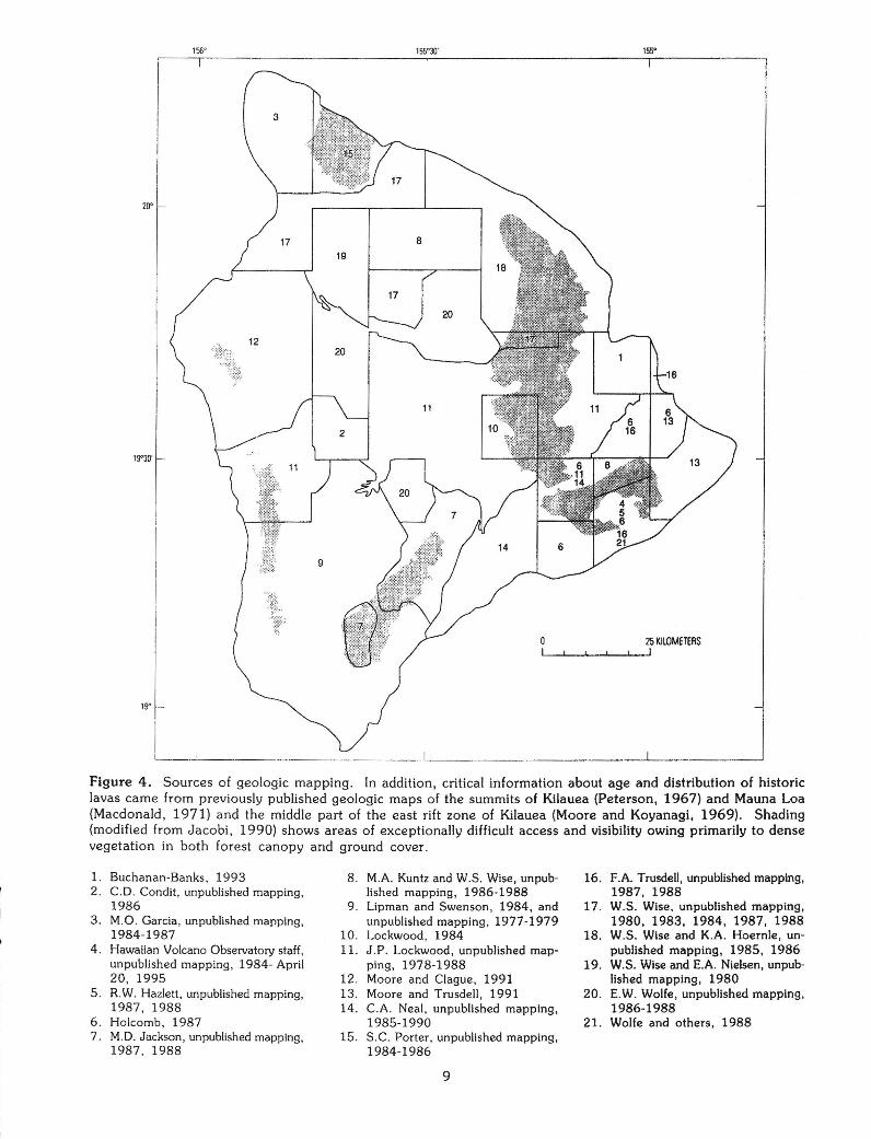
This map is a compilation of geologic mapping from 1975 through 1988 by approximately 20 geologists (fig. 4), with a subsequent update for Kilauea lavas emplaced through April 20, 1995, in a continuing eruption. Earlier maps provided critical information about ages of historic lavas in Kilauea Crater (Peterson, 1967), Mokuaweoweo (Macdonald, 1971), and the middle part of the east rift zone of Kilauea (Moore and Koyanagi, 1969). The geology was mapped in the field on aerial photographs or interpreted from aerial photographs and then field checked. Generally, the mapping was transferred from the aerial photographs to 1:24,000-scale topographic quadrangle maps and then reduced for compilation at 1:100,000 scale.
Some parts of the island have little or no forest cover, and other parts are covered by dense tropical forest. Because heavily forested areas have limited visibility and generally difficult access, the geologic mapping there is commonly more generalized than where access and visibility are good. Thus, the distribution of dense forest (fig. 4) is a useful guide to the areas of more generalized geologic mapping. Some internal contacts on the northeast flank of Mauna Kea and upper southwest flank of Kohala are truncated at boundaries of ranch lands or cane fields with dense forest.
Individual lava flows and their vent deposits were mapped where possible. Common criteria for distinguishing one flow from the next in the field include size, type, and abundance of phenocrysts, groundmass texture, flow morphology, and degree of stJrface alteration 'or mantling by tephra.
The emphasis of the map is strongly chronostratigraphic. Lavas of latest Pleistocene and Holocene age, which include an of the Kau Basalt, Puna Basalt, and basaltic lavas of the Hualalai Volcanics and cover most of the southern two-thirds of the island, are grouped by age (see Correlation of Map Units; on map sheet 2). Their age assignments are based on observed stratigraphic relations, degree of alteration of the initially glassy flow surfaces, radiocarbon ages {mostly from charcoal fragments collected beneath lava flows; Lockwood and Lipman, 1980), and paleomagnetic measurements (for example, Holcomb, 1987; D.E. Champion, written commun., 1987). Older units are lithostratigraphic; assignment of lavas to them is based not upon age but rather upon factors such as mineralogy, composition, and stratigraphic and physiographic relationships.
Within limited areas, degree of surface alteration provides an effective basis for grouping the Holocene flows by age. For example, Lipman and Swenson (1984) outlined explicit age-related surface-alteration criteria applied to lava flows of the Kau Basalt above tree line in the southwest rift zone of Mauna Loa Volcano (table 1). However, rate and style of surface alteration differ with differing environmental factors such as elevation, rainfall, and forest cover. Thus, there are no island-wide field criteria for chronostratigraphic assignment of prehistoric lava flows, and radiocarbon ages pro-
155'
20'
19'30'
25 KilOMETERS
19' --
Figure 4. Sources of geologic mapping. In addition, critical information about age and distribution of historic lavas came from previously published geologic maps of the summits of Kilauea (Peterson, 1967) and Mauna Loa (Macdonald, 1971) and the middle part of the east rift zone of Kilauea (Moore and Koyanagi, 1969). Shading (modified from Jacobi, 1990) shows areas of exceptionally difficult access and visibility owing primarily to dense vegetation in both forest canopy and ground cover.
1. Buchanan-Banks, 1993 8. M.A. Kuntz and W.S. Wise, unpub· 16. F.A. Trusdell, unpublished mapping, 2 . C.D. Condit, unpublished mapping, lished mapping, 1986-1988 1987, 1988
1986 9 . Lipman and Swenson, 1984, and 17. W.S. Wise, unpublished mapping, 3. M.O. Garcia, unpublished mapping, unpublished mapping, 1977-1979 1980, 1983, 1984, 1987, 1988
1984-1987 10. Lockwood, 1984 18. W.S. Wise and K.A. Hoernle, un· 4 . Hawaiian Volcano Observatory staff. 11. J.P. Lockwood, unpublished map- published mapping, 1985, 1986
unpublished mapping, 1984- April ping, 1978-1988 19. W.S. Wise and E.A. Nielsen, unpub-20, 1995 12. Moore and Clague, 1991 lished mapping, 1980
5 . R.W. Hazlett, unpublished mapping, 13. Moore and Trusdell, 1991 20. E.W. Wolfe, unpublished mapping. 1987, 1988 14. C.A. Neal , unpublished mapping, 1986-1988
6 . Holcomb, 1987 1985-1990 21. Wolfe and others, 1988 7 . M.D. Jackson, unpublished mapping, 15. S.C. Porter, unpublished mapping,
1987. 1988 1984-1986
9
vide essential calibration for locally applicable field criteria. Tephra deposits, commonly intensely altered by
weathering, mantle the surfaces of many Pleistocene lava flows and provide parent material for soils that support much of the island's agriculture. Because the mapping effort was directed toward lava stratigraphy and chronology, tephra units generally were mapped only where the deposits are so thick and extensive that the underlying lavas are completely masked.
Radiocarbon ages used for chronostratigraphic control are shown on the map as mean ages without values for standard deviation indicative of statistical counting error. Supporting data are given with Map 1-2524-B. Radiocarbon ages have not been calibrated (that
is, converted to best-fit calendar dates); thus, age discussions for prehistoric units refer to radiocarbon years except where specific reference is made to K-Ar dating. Some radiocarbon ages are irreconcilable with well-established stratigraphic constraints. Such ages are generally too young and have commonly been determined from charcoal collected at the bases of aa flows. Repeated experience indicates that young charcoal fragments (for example, from forest fires long after a lava flow was emplaced) readily sift through aa and contaminate any charcoal that might have been preserved when the flow was emplaced. Such ages are not included on the map.
Table 1. Weathering characteristics of Holocene lava flows of the Kau Basalt, southwest rift zone of Mauna Loa
Volcano, Hawaii (Lipman and Swenson, 1984)
Unit Dominant color of lava surface
Pahoehoe A a
k5 Black Dark brown
k4 Black to dark gray Light brown
k3 Gray to tan Yellow-tan
k2 Light brown Tan-orange
k1 Brown, orange brown, and Red-orange
red brown
DESCRIPTION OF MAP UNITS
KILAUEA VOLCANO Spatter or tuff cones
peS
pc4y
pc4o
pc3
pc2
Lava flows
p5
p4y p4
p4o
p3
p2
p1y
p1o
Littoral Tephra cones deposits
pld5 paS I
pld4o pa4o
pld3
pa2 I
Age ka
0.0 - 0.2
0.2- 0.4
0.4 - 0.75
0.75 - 1.5
1.5 - 3.0
3.0- 5.0
5.0 - 10.0
Puna Basalt (Holocene)-Lava flows, vent deposits, littoral deposits, and tephra deposits of tholeiitic basalt and rare transitional and alkalic basalt (fig. 2) of Kilauea Volcano. Contains variable amounts of phenocrysts of olivine, plagioclase, and, rarely, pyroxene. Flows consist of pahoehoe or aa, commonly both; most issued initially from elongate fissures. Fallout from lava fountains along the fissures commonly built low ramparts of spatter that are not distinguished on the map from their related lava flows.
Pyroclastic vent deposits are mapped where they form prominent spatter or tuff cones. The cones
10
Weathering character of pahoehoe surface
Unweathered shiny fresh glass
Original glassy surfaces well preserved; only
slight weathering
Some original surfaces; thin weathering rind
Original surfaces mostly destroyed
Original surfaces destroyed; deep weathering
rind
generally consist of spatter and minor scoria. They formed where lava fountaining was concentrated along a short fissure segment for sufficient time, generally days to weeks, to build a steep-sided mound tens to hundreds of meters in diameter. One large cone, Kapoho Crater {in unit pc4y), located 4 km southwest of Cape Kumukahi (the island's southeast cape), consists of bedded tuff containing rock and mineral fragments from older basalt flows as well as juvenile scoria and bombs. The base of the cone is only 20 m above sea level, and the tuff apparently records explosive interaction of ascending magma with seawater (Moore, 1992).
Fissure eruptions have generally produced sheets of vesicular pahoehoe that converted to aa with increasing distance from the vent, especially as lobes of lava became channelized and formed elongate flows. Fissure vents largely freeze and become inactive in prolonged eruptions, and lava discharge becomes concentrated at one or more local point-source vents. Such vents that erupt at relatively high rates generally produce elongate aa flows. For example, repeated episodic eruptions from 1983 to 1986 at Puu Oo in the middle part of the east rift zone produced a complex flow field (unit p5, 1983-86) composed of numerous individual elongate aa flows (Wolfe and others, 1987, 1988). On the other hand, slow, continuous eruption of lava from a point vent, prolonged over months to years, builds a low lava shield that extends outward into

an extensive flow field dominated by relatively dense tube-fed pahoehoe. Mapped historic examples of such shields include Mauna lki {unit p5, 1919) in Kilauea's southwest rift zone and Mauna Ulu {unit p5, 1972-74) and Kupaianaha (unit p5, 1986-92) in the east rift zone. Important prehistoric examples include Kane Nui o Hamo (unit p4o} in the upper east rift zone and Heiheiahulu (unit p4y) in the middle part of the east rift zone. Prehistoric shield remnants near the present north and east rims of Kilauea Crater, the Observatory and Ai-laau shields, respectively, of Holcomb (1987), erupted tube-fed pahoehoe flow fields that reach far southwestward (unit p4o) and eastward (unit p4).
Cone-building littoral deposits (units pld5, pld4o, and pld3} formed where some lava flows entered the ocean and were violently fragmented by ensuing steam explosions. The resulting shoreline deposits consist of ash, lapilli, and bombs of dense glassy basalt.
Mapped tephra deposits include local air-fall deposits of ash and lapilli (unit pa5, 1959, near Kilauea lki Crater; unit pa5, 1960, near Kapoho Crater), lithic tuff with basaltic lava fragments (unit pa4o) from explosive eruptions at Puulena Crater in the lower east rift zone (Moore, 1992), and relatively widespread air-fall and surge deposits (units pa2 and paS, 1790) that record violently explosive, steam-driven eruptions at Kilauea's summit (Dzurisin and others, 1995; McPhie and others, 1990).
Unit pa2, shown over a broad area north of Kilauea Crater, corresponds to the Uwekahuna Ash Member of the Puna Basalt. Less than a meter thick where mapped (outside of Kilauea Crater), the unit consists mostly of layered lithic and vitric ash and lapilli. Two depositional episodes, both marked by phreatomagmatic explosions and lava fountaining, are represented; sufficient time elapsed between the eruptive episodes for the vegetation to recolonize. Radiocarbon ages indicate that the earlier eruptions occurred between approximately 2.8 and 2.2 ka, and the later eruptions at about 2.1 ka (Dzurisin and others, 1995).
Unit paS, 1790, which surrounds Kilauea Crater but has been almost completely buried by younger lavas within the caldera, corresponds to the Keanakakoi Ash Member of the Puna Basalt. The unit consists of complexly bedded deposits of ash, lapilli, and blocks. Thin layers of basaltic pumiceindicative of lava fountaining-occur at the top and bottom of the ·Keanakakoi. Pyroclastic deposits between the bounding pumice layers are locally more than 10 m thick; they change upward from well-bedded vitric ash dominated by juvenile fragments to coarse, crossbedded, lithic-rich deposits of ash, lapilli, and blocks. The sequence is attributed to repeated explosions driven by rapid expansion of water to steam. In the early eruptive phases, groundwater gained access to vesiculating magma, which repeatedly produced air-fall deposits of vitric ash; in later phases, withdrawal of magma from the conduit gave the groundwater direct access to hot,
11
collapsing, wall rocks of the conduit, and the ensuing steam explosions generated coarse lithic-rich pyroclastic surges, one of which killed a party of Hawaiian warriors traveling southwest of Kilauea Crater (McPhie and others, 1990)
hi
Hilina Basalt (Pieistocene)-Lava flows and intercalated ash deposits exposed in kipukas south of Kilauea Crater on the volcano's south flank. Lava flows, both aa and pahoehoe, constitute about 95 percent of the exposed sequence, which is at least 300 m thick. Lava flows are tholeiitic basalt with or without phenocrysts of olivine, plagioclase, and, rarely, pyroxene. Flows are generally fresh except for the rubbly aa flow tops, which are partly or totally weathered to reddish-brown clay and commonly contain soil or palagonite horizons in their upper parts. Intercalated ash layers are as much as 4 m thick; they consist mostly of vitric and lithic ash altered in varying degrees to palagonite (Easton, 1987). Major ash units or groups of ash units intercalated with lava flows of the Hilina Basalt have been assigned to the Moo, Pohakaa, Kahele, and Halape Ash Members of the Hilina Basalt (Easton, 1987). Unit underlies the Pahala Ash and, therefore, is older than 23 ka. Thin lava flows intermediate in age between the Hilina Basalt and unit p2 may be included locally with the Hilina Basalt as mapped in the upper parts of cliff exposures along Hilina Pali
Spatter or scoria cones
kcS
kc4
kc3
kc2
kc1y kc1
kc1o
kc
MAUNA LOA VOLCANO
Lava flows
k5
k4
k3
k2
k1 k1y
k1o
k
Littoral Tephra cones deposits
kidS
kld4
kld3 ka3 I kld2
kld1
Ageka
0.0 - 0.2
0.2 - 0.75
0.75 - 1.5
1.5 - 3.0
3.0- 5.0
5.0 - 10.0
>10.0
Kau Basalt (Holocene and Pleistocene)-Lava flows, vent deposits, littoral deposits, and tephra-fall deposits of tholeiitic basalt and rare transitional basalt {figs. 2 and 3) of Mauna Loa Volcano. Contains variable amounts of phenocrysts of olivine, plagioclase, and, rarely, pyroxene. Aows consist of pahoehoe or aa, commonly both; most issued initially from elongate fissures. Lava fountains along the fissures commonly built low ramparts of spatter that are not distinguished on the map from their related lava flows.
Pyroclastic vent deposits are mapped where they form prominent cones. The cones generally consist of spatter and minor scoria. They formed where lava fountaining was concentrated along a short

fissure segment for sufficient time, generally days to weeks, to build a steep-sided mound tens to hundreds of meters in diameter.
Vesicular pahoehoe that was fed by vigorous lava fountains dominates along the rift zones but changes downslope to aa that commonly forms relatively long, narrow flows. Data for historic eruptions (Peterson and Moore, 1987) indicate that many of these flows formed during relatively brief { 1-3 weeks) eruptions that had high rates of lava output. Such conditions favor development of an extending, narrow, open lava channel, confined within levees of its own making, that efficiently delivers lava to a broad toe of slowly advancing aa (Lipman and Banks, 1987). In contrast, some of the longest flows, such as the lava flow of 1859, which reached the west coast of the island north of Hualalai Volcano, and the 1880-81 flow, which reached Hilo, were produced by more protracted eruptions (300 and 280 days, respectively) in which slower, steady lava output led to formation of lava tubes and production of dense tube-fed pahoehoe.
Lava shields along the rift zones are smaller and less conspicuous than those of Kilauea, but the present summit caldera truncates a former summit shield that spawned extensive tube-fed pahoehoe flow fields (part of unit k3) west to northwest and southeast of the summit. Radiocarbon ages of lavas of the two flow fields indicate that the shield was active from at least 1,500 to 1,100 yr B.P.
Cone-building littoral deposits (units kidS, kld4, kld3, kld2, and kld1) formed where some lava flows entered the ocean and were violently fragmented by ensuing steam explosions. The resulting shoreline deposits consist of ash, lapilli, and bombs of dense glassy basalt.
A mapped tephra-fall deposit (unit ka3, 12 km north of Kilauea caldera) consists of ash and lapilli that was blown southwest during the eruption that built the nearby 1-km-diameter cone (unit kc3) in the Kulani Project area.
Units k1 through k4 are equivalent to Mauna Loa southwest-rift-zone units kp 1 through kp4 of Lipman and Swenson (1984), whereas unit k5 includes their southwest-rift-zone unit kp5 plus the lava flows of their historic member.
Unit k is equivalent to the southwest-rift-zone transitional unit (unit kptu) of Lipman and Swenson ( 1984), which they describe as basalt flows interlayered with discontinuous lenses of weathered Pahala-like basaltic ash, some of which is reworked from the main Pahala Ash and some of which may represent primary ash deposits. Radiocarbon ages of unit k range from approximately 10 to 31 ka
Kahuku Basalt (Pieistocene)-Lava flows of tholeiitic basalt from Mauna Loa Volcano that resemble some flows of the Kau Basalt in composition, texture, and degree of weathering but underlie the Pahala
12
Ash, as shown in outcrops at Waiohinu, on Mauna Loa's southeastern coast, and along the Kahuku Fault at the south end of the island. Unit is older than the 31-ka flow of unit k, which overlies the Pahala Ash near Naalehu
n
Ninole Basalt (Pieistocene)-Lava flows of tholeiitic basalt exposed as erosional remnants on scattered hills in the southern part of Mauna Loa's southeast flank. Deep canyons, resembling those of the northeast flank of Kohala, separate hills underlain by the Ninole Basalt and have been partly filled by ash and younger lava flows. Unit consists of thin flows of aa and pahoehoe with some thin interbeds of basaltic tuff; dikes (unmapped) of similar basalt locally intrude unit. Basalt typically contains 1 to 10 percent olivine phenocrysts; some contains plagioclase phenocrysts as well. K-Ar dating, difficult because of low initial potassium in the Ninole Basalt and its probable loss during weathering, suggests the age of the Ninole is 100 to 200 ka, and possibly as old as 300 ka (Lipman and others, 1990). Ninole flows may be eruptive products of an early south rift zone of Mauna Loa (Lipman and others, 1990). Massive landsliding of the west flank of Mauna Loa, culminating by about 100 ka, triggered westward migration of the rift zone and concentrated eruptive activity within a huge landslide scar on the west flank, thus protecting Ninole flows on the east flank from burial by younger lava. Steepening of the east flank by additional landsliding may have accelerated canyon cutting
HUALALAI VOLCANO
Hualalai Volcanics (Holocene and Pleistocene)-Transitional and alkali basalt and trachyte, all erupted from Hualalai Volcano. Consists of:
Spatter or scoria Lava Tephra
cones flows deposits
hc5 h5
hc4 h4 ha4 I hc3 h3
hc2 h2
hc1y h1y
hc1o h1o
he h
Age ka
0.0- 0.2
0.2 - 0.75
0.75 - 1.5
1.5 - 3.0
3.0- 5.0
5.0 - 10.0
>10.0
Basalt (Holocene and Pleistocene)-Lava flows and vent deposits of alkalic and transitional basalt and minor hawaiite (fig. 2) and a tephra deposit. Basalt generally contains phenocrysts of olivine and may include phenocrysts of plagioclase or clinopyroxene. Mafic and ultramafic xenoliths are common. Flows consist of pahoehoe, aa, or both. Radio-
carbon ages indicate that the oldest exposed basalt flow of the Hualalai Volcanics is at least as old as 13 ka. The youngest flow is lava of a historic eruption (unit h5} in 1800-01 that reached the coast near Kiholo Bay and just north of Keahole Point.
Pyroclastic vent deposits consist of numerous small spatter deposits (mostly denoted by asterisks within their mapped flow units}, many larger cones of scoria and spatter, and a few relatively short fissure vents. Absence of long parallel fissure vents, normal faults, and open cracks suggests that the vigorous cross-rift extension and repeated intrusion of elongate, parallel dikes that characterize active rift-zone activity on Kilauea and Mauna Loa no longer operate on Hualalai.
A single tephra deposit (unit ha4) is shown near the southern end of Hualalai. It consists of weakly consolidated, light-gray tuff that contains lapilli and blocks of alkalic basalt, tholeiitic basalt, and trachyte. The deposit records violent steam-driven explosions that occurred about 700 yr B.P. (Moore and Clague, 1991)
Scoria Lava cone flow
I we I w
Waawaa Trachyte Member (Pleistocene)-Trachyte cone (unit we) of Puu Waawaa and trachyte flow (unit w} of Puu Anahulu (5 km northwest of Puu Waawaa). Trachyte contains fewer than 1 percent phenocrysts; these consist of biotite, plagioclase, and pyroxene. Cone consists of generally loose fragments of pumice, obsidian, and massive to flow-banded trachyte; flow is commonly sheared and color is altered to light brown (Moore and Clague, 1991). The presence of similar trachyte as blocks in unit ha4 on the volcano's south flank, as xenoliths elsewhere on Hualalai, and in a water well at Huehue on the northwest flank of the volcano about 12 km northwest of the summit indicates that trachyte is widespread in the subsurface. K-Ar ages for trachyte samples from Puu Waawaa, the Huehue well, and from the blocks of unit ha4 are statistically indistinguishable and, taken together, indicate that trachyte erupted from several vents at approximately 100 to 105 ka (Clague, 1987)
MAUNA KEA VOLCANO
Laupahoehoe Volcanics (Holocene and Pleistocene)Volcanic rocks, composed of hawaiite, mugearite, and benmoreite, and associated glacial deposits.
The lavas are generally aphyric, but a few contain small platy plagioclase phenocrysts. The groundmass is plagioclase rich; trachytic texture, characterized by strongly preferred alignment of plagioclase crystals in the groundmass, is commonly conspicuous, which gives freshly broken rock surfaces a sheen not seen in basalt. Gabbroic and ultramafic xenoliths occur locally. Consists of:
13
Scoria Lava Tephra cones flows deposits
Icy I ly I lay I Younger volcanic rocks member (Holocene and Plels
tocene?)-Lava flows, scoria cones, and tephra-fall deposits of hawaiite and mugearite {fig. 2) that postdate the Makanaka Glacial Member (units lmt and lmo).
Flows (unit ly) are predominantly aa and blocky aa; dense pahoehoe occurs locally. Flow interiors are dense, massive, and gray; flow surfaces are brown to gray, marked by less weathering and erosion of primary surface detail than nearby flows of the older volcanic rocks member (units I and lb), and free or nearly free of mantling eolian or tephra-fall deposits.
Scoria cones (unit Icy) consist mostly of vesicular lapilli with lesser amounts of ash and bombs; agglutinated spatter occurs locally. Cones are dark gray to red where freshly exposed and are generally steeper and more sharply rimmed than cones of the older volcanic rocks member.
Tephra-fall deposits (unit lay) consist of lapilli and ash distributed downwind from pyroclastic eruption columns. Deposits are black where freshly exposed and yellowish-brown where weathered. They are mapped only where most extensive and continuous.
Stratigraphic and physiographic relations, general absence of mantling surficial deposits, and radiocarbon ages are used to distinguish the unit from the older volcanic rocks member. Radiocarbon ages range from about 4.4 to 7.1 ka; these ages probably date the youngest, but not the oldest, lavas of the younger volcanic rocks member
Tephra Scoria cones Lava flows deposits
lc I be lb Ia
Older volcanic rocks member (Holocene and Pleistocene)-Lava flows, scoria cones, and tephra-fall deposits of hawaiite, mugearite, and benmoreite (fig. 2). Benmoreite is identified on the basis of chemical composition. Flows of hawaiite or mugearite (unit I) and benmoreite (unit lb) are predominantly aa and blocky aa; dense pahoehoe occurs locally. Flow interiors are gray, dense, and massive; some contain interlayered aa breccia. Flow surfaces are yellowish brown to dark brown, and in general, partly mantled by unmapped eolian, tephra-fall, or colluvial deposits. On the east flank of the volcano, in areas of dense rain forest, mapping is generalized, and the unit as mapped may include exposures of lava flows of the Hamakua Volcanics.
Scoria cones of hawaiite or mugearite (unit lc) and benmoreite (unit lbc) consist mostly of vesicular lapilli with lesser amounts of ash and bombs; agglutinated spatter occurs locally. Cones are generally dark gray to red where freshly exposed and

yellowish brown where weathered; however, interiors that have been hydrothermally altered are grayish orange to yellowish orange and weakly cemented. Cones are locally mantled by unmapped fine-grained deposits of eolian or tephra-fall origin.
Tephra-fall deposits (unit Ia) consist of lapilli and ash distributed downwind during eruptions from the pyroclastic eruption columns. Deposits are black where freshly exposed and yellowish-brown where weathered. They are mapped only where most extensive and continuous. Unit locally includes tephra stratigraphically equivalent to part of the younger volcanic rocks member.
K-Ar ages {Wolfe and others, in press) combined with exposure ages (Dorn and others, 1991) indicate an age range of about 65 to 14 ka {Pleistocene) for the rocks of this member (except unit Ia)
Glacial deposits
I lmt I lmo I Makanaka Glacial Member (Pleistocene)-Till {unit
lmt) and outwash (unit lmo). Till consists of massive, poorly consolidated diamict containing angular to subrounded cobbles and boulders, some more than 2m in diameter, in an unsorted, finer grained, gray to light-yellowish-brown matrix. Cobbles and boulders are mostly dense, light- to medium-gray hawaiite or mugearite from the older volcanic rocks member of the Laupahoehoe Volcanics. Boulder surfaces are mostly light gray to tan or yellowish brown.
Outwash consists of unconsolidated gravel containing subrounded to rounded cobbles and boulders similar to those of till of the Makanaka Glacial Member.
K-Ar ages of lava flows erupted before or during the Makanaka glaciation (Wolfe and others, in press) combined with exposure ages (Dorn and others, 1991) indicate an age range of about 40 to 14 ka for the deposits of this member
Hamakua Volcanics (Pleistocene)-Basaltic volcanic rocks and associated glacial deposits. Consists of:
Scoria Lava cones flows
I hmc I hm
Basalt-Lava flows and cinder cones of alkalic and transitional basalt and minor hawaiite, tholeiitic basalt, and strongly undersaturated basalt (fig. 2). Lavas contain variable amounts o"f olivine, plagioclase, and clinopyroxene phenocrysts.
Flows (unit hm) consist of aa and pahoehoe from vents widely distributed over the subaerial flanks of the volcano. Flows are dark gray where fresh, but surfaces are largely weathered to yellowish brown or brown, show little if any relict flow-surface texture, and are discontinuously mantled by unmapped eolian, tephra-fall, and colluvial deposits.
Scoria cones consist mostly of vesicular lapilli with lesser amounts of ash and bombs; agglutinated
14
spatter occurs locally. Topographic profiles have been subdued by erosion and mass wasting, and surfaces are locally mantled by unmapped tephra-fall and eolian deposits.
As mapped, unit includes unmapped tiiJ of the Pohakuloa Glacial Member, which is exposed in walls of Waikahalulu and Pohakuloa Gulches on the steep south flank of Mauna Kea.
K-Ar ages indicate an age range from approximately 200 to 250 ka to 65 to 7 0 ka for the rocks of this unit (Wolfe and others, in press)
I hmw l Waihu Glacial Member-Glacial drift composed of
diamict and gravel. Diamict is massive to crudely layered and consists of subangular to subrounded cobbles and boulders derived from lava flows of the Hamakua Volcanics, which are enclosed in a moderately indurated, gray to yellowish-brown to reddish-brown, unsorted matrix. Gravel, composed of layered, sorted cobbles and boulders similar to those in the diamict, occurs as local lenses or tongues. Unit lies stratigraphically high within the Hamakua Volcanics; it is overlain by youngest Hamakua flows. Age is poorly constrained by K-Ar dating to between approximately 150 and 70 ka (Wolfe and others, in press), but exposure age is about 70 to 60 ka (Dorn and others, 1991)
KOHALA VOLCANO
Scoria Lava Lava Tephra cones domes flows deposits
hwc hwd hw hwa I hwbc hwbd hwb
hwtd hwt
Hawi Volcanics (Pieistocene)-Lava flows, scoria cones, lava domes, and tephra-fall deposits of hawaiite, mugearite, benmoreite, and trachyte (fig. 2). Lavas are aphyric to sparsely porphyritic Oess than 1 volume percent phenocrysts, mostly plagioclase). The groundmass is plagioclase rich; trachytic texture, characterized by strongly preferred alignment of plagioclase crystals in the groundmass is commonly conspicuous, which gives freshly broken rock surfaces a sheen that is not seen in basalts. Benmoreite and trachyte are identified on the basis of chemical composition.
Aows composed of hawaiite and mugearite (unit hw), benmoreite (unit hwb), and trachyte (unit hwt) originate from numerous vents on the topographic crest and flanks of the volcano. Flows are light to medium gray, relatively thick (3-30 m), and are generally blocky. Primary flow-surface textures have been largely obliterated by weathering and erosion, and flow surfaces are locally mantled by unmapped tephra-fall and eolian deposits.
Vents are marked by scoria cones or steep-sided lava domes and include hawaiite-mugearite cones (unit hwc), benmoreite cones (unit hwbc),

hawaiite-mugearite domes (unit hwd), benmoreite domes {unit hwbd), and a trachyte dome (unit hwtd).
Local tephra-fall deposits (unit hwa) are mapped adjacent to several cinder' cones near the east end of the volcano.
K-Ar ages (McDougall, 1969; McDougall and Swanson, 1972; Spengler and Garcia, 1988; G.B. Dalrymple, written commun., 1989) of lava flows from unit range from about 230 to 120 ka. This range excludes an age of approximately 60 ka that McDougall and Swanson reported for a Hawi lava flow near Kukuihaele. The Hawi flow is overlain by a flow of the Hamakua Volcanics that has a K-Ar age of 187 ± 40 ka (Wolfe and others, in press), and its reported age of 60 ka is younger than all lavas of the Hamakua Volcanics
Lava Scoria cones dome Lava flows
1 pic 1 plmc 1 pld 1 pi 1 plm 1
Pololu Volcanics (Pieistocene)-Lava flows, cinder cones, and a lava dome. Lavas are mostly basaltic: tholeiitic, transitional, and alkalic basalt, including hawaiite (fig. 2), which contain variable percentages of olivine, plagioclase, and, in the younger (transitional and alkalic) lavas, clinopyroxene phenocrysts (Stearns and Macdonald, 1946). Plagioclase-phyric basalt is especially common in the upper part of the Pololu, whereas aphyric or olivine-phyric lavas predominate in the canyon-wall and sea-cliff exposures of the northeast flank. Mugearite lavas, which represent a minor local occurrence within the Pololu Volcanics, are identified on the basis of chemical composition.
Basaltic lava flows constitute unit pi and mugearite flows unit plm. Transitional and alkalic basalt, mostly aa, forms much of the upland surface of the volcano. Many of the surface flows can be traced to cinder cones, some of which are along the volcano's crest. Primary surface fabrics of these flows have been largely obliterated by weathering and erosion, and the flow surfaces are locally mantled by unmapped eolian and tephra-fall deposits. Pahoehoe and aa flows of tholeiitic basalt, broadly similar in composition to the tholeiitic basalt lavas of Kilauea and Mauna Loa (figs. 2 and 3), are exposed in the deep valleys and sea cliffs on the northeast flank and in Honokoa Gulch, the deepest valley of the southwest flank. These relations suggest that the alkalic basalts comprise only a thin cap and that the deep-canyon and seacliff exposures represent the upper part of the tholeiitic shield-stage lavas.
Vents for some of the younger lavas are marked by basaltic scoria cones (unit pic), a mugearite scoria cone (unit plmc), and a basaltic dome (unit pld) near the southeast end of the volcano.
K-Ar ages (McDougall, 1969; McDougall and Swanson, 1972; G.B. Dalrymple, written commun., 1989) indicate that the transition from eruption of
15
tholeiitic basalt to eruption of transitional and alkalic basalt had occurred by about 400 ka, and eruption of transitional and alkalic basalt continued until at least about 250 ka.
A weighted mean age of approximately 700 ka was calculated for five tholeiitic lava flows low on the southeast wall of Waipio Valley near its mouth (Dalrymple, 1971). The entire sequence of lavas in the valley wall section has normal magnetic polarity (Doell and Cox, 1965). The weighted mean age and normal polarity imply that the sampled lavas, and probably all of the exposed lavas of Kohala Volcano, were erupted later than the onset of the Brunhes Normal-Polarity Chron at approximately 780 ka
REGIONAL ASH DEPOSITS
~ Pahala Ash (Pleistocene)-Deeply weathered ash
deposits commonly altered to a yellowish-orange to reddish-brown mixture of clay minerals and hydrated oxides. Unit occurs in numerous kipukas surrounded by younger lavas on Kilauea and Mauna Loa and predates the earliest lavas of Holocene age on those volcanoes. As a stratigraphic term, the name "Pahala" has had a long and complex history {Langenheim and Clague, 1987) as have the deposits that comprise the Pahala Ash. Stearns and Macdonald (1946) considered deeply weathered ash over much of the island to be the Pahala Ash. They interpreted its origin as both primary and reworked tephra-fall deposits that originated from Kilauea, Mauna Loa, Mauna Kea, and Kohala Volcanoes. The provenance of the ash in any locality is related to the proximity of the deposit to its sources and the direction of the prevailing winds.
On Kilauea, the Pahala Ash separates the Hilina Basalt from younger lavas of the Puna Basalt. The Pahala Ash consists of altered basaltic ash with locally interlayered basalt flows that resemble those of the overlying Puna Basalt. Its average thickness is about 15 m (Easton, 1987). Two radiocarbon ages, for charcoal from the ash beneath one of the interlayered lava flows, are each approximately 23 ka.
On southern Mauna Loa, as much as 10 m of deeply weathered basaltic ash separates unit k of the Kau Basalt from the underlying Kahuku Basalt southwest of Pahala (Lipman and Swenson, 1984). A radiocarbon age of 31,100±900 yr B.P. for a lava flow of unit k of the Kau Basalt directly above this ash unit near Naalehu indicates that the age of the ash unit is at least 30 ka. Lipman and Swenson (1984) assigned this ash unit to the Pahala Ash and explicitly excluded younger ash interlayered with lava flows of their transitional unit (unit k of this map). Nevertheless, in describing the interlayered Pahala-like ash of unit k, they referred to the ash below unit k as the main Pahala Ash. Areally extensive ash west of Pahala resembles the main Pahala Ash but overlies and is interlayered with lava flows, suggesting that it is ash of unit k, not
the Pahala Ash in the restricted usage of Lipman and Swenson (1984). Because of uncertainty about whether any individual outcrop of deeply weathered Pahala-like ash on Mauna Loa is equivalent to the main Pahala Ash or to younger ash within unit k, we have reluctantly assigned all deeply weathered ash on the southeast flank of Mauna Loa to the Pahala Ash.
Also included in the Pahala Ash are deeply weathered ash deposits near Hilo, found both in kipukas within the Kau Basalt on the northeast flank of Mauna Loa and mantling the Hamakua Volcanics on the nearby part of Mauna Kea. These deposits, which Buchanan-Banks (1993) referred to informally as Homelani ash, are at least 6 m thick near the boundary between Mauna Loa and Mauna Kea and thin both to the north and south {Buchanan-Banks, 1983). The ash underlies and is interlayered with lavas of unit k of the Kau Basalt and is older than 14 ka. Thus it occupies much the same stratigraphic position as the Pahala Ash mapped on Kilauea and southern Mauna Loa.
The indefinite boundary of the Pahala Ash 2 to 4 km north of the contact between Mauna Loa and Mauna Kea near Hilo reflects both northward thinning of the ash and a change in mapping style from showing the ash as a continuous mantling unit to mapping instead the lava flows beneath the discontinuous ash cover
SURFICIAL DEPOSITS
Fill (Holocene)-Artificial fill forming the harbor breakwater at Kawaihae
Is
Landslide deposits (Holocene)-Unit includes deposits of basalt blocks, soil, and vegetation that slid from the steep valley walls and sea cliffs on the northeast flank of Kohala Volcano. Some historic landslides were triggered by storms or earthquakes, including the earthquakes of 1868 and 1929 (Stearns and Macdonald, 1946).
Also includes prehistoric and historic (1868) landslide deposits in and near Wood Valley on the southeast flank of Mauna Loa. These deposits consist of breccia that contains up to 80 percent angular and shattered basalt blocks, as large as a meter or more, in a muddy orange matrix derived from the Pahala Ash. The landslide of 1868 was caused by gravitational failure of basalt overlying wet ash on the volcano's steep flank following the earthquake of 1868; it buried a village, killing 31 people and much livestock (Stearns and Macdonald, 1946)
I ac J
Alluvium and colluvium (Holocene and Pleistocene)Sand and gravel derived from lava flows and pyroclastic deposits; distributed by both running water and downslope movement. Unit also includes local eolian deposits and coralline beach sand
16
e
Eolian deposits (Pleistocene)-Dark-gray, unconsolidated, crossbedded, very fine grained to fine-grained dune sand. Interpreted as deposits of reworked ash derived from eruptions that formed the Laupahoehoe Volcanics along the lower southwest flank of Mauna Kea
I sd I Slope deposits (Pleistocene)-Interlayered fluvial, eolian,
debris-flow, and tephra-fall deposits on south flank of Mauna Kea
REFERENCES CITED
Buchanan-Banks, J.M., 1983, Reconnaissance map showing thicknesses of volcanic ash deposits in the greater Hilo area, Hawaii: U.S. Geological Survey Miscellaneous Field Studies Map MF-1499.
---1993, Geologic map of the Hilo 71/2-minute quadrangle, Island of Hawaii: U.S. Geological Survey Miscellaneous Investigations Series Map 1-2274, scale 1:24,000.
Clague, D.A., 1987, Hawaiian xenolith populations, magma supply rates, and development of magma chambers: Bulletin of Volcanology, v. 49, no. 4, p. 577-587.
Clague, D.A., and Dalrymple, G.B., 1987, The Hawaiian-Emperor volcanic chain. Part I. Geologic evolution, in Decker, R.W., Wright, T.L., and Stauffer, P.H., eds., Volcanism in Hawaii: U.S. Geological Survey Professional Paper 1350, v. 1, p. 5-54.
---1989, Tectonics, geochronology, and origin of the Hawaiian-Emperor Chain, in Winterer, E.L., Hussong, D.M., and Decker, R.W., eds., The eastern Pacific Ocean and Hawaii: Geological Society of America, The Geology of North America, v. N, p. 188-217.
Clague, D.A., and Denlinger, R.P., 1993, The role of cumulate dunite in destabilizing the flanks of Hawaiian volcanoes [abs.]: Ancient volcanism and modern analogues, International Association for Volcanology and Geochemistry of the Earth's Interior, General Assembly, September 1993, Canberra, Australia, Abstracts, p. 21.
Dalrymple, G.B., 1971, Potassium-argon ages from the Pololu volcanic series, Kohala Volcano, Hawaii: Geological Society of America Bulletin, v. 82, no. 7, p. 1,997-2,000.
Daly, R.A., 1910, Pleistocene glaciation and the coraf reef problem: American Journal of Science, ser. 4, v. 30, no. 179, p. 297-308.
Decker, R.W., 1987, Dynamics of Hawaiian volcanoes: an overview, in Decker, R.W., Wright, T.L., and Stauffer, P.H., eds., Volcanism in Hawaii: U.S. Geological Survey Professional Paper 1350, v. 2, p. 997-1,018.
Decker, R.W., Koyanagi, R.Y., Dvorak, J.J., Lockwood, J.P., Okamura, A.T., Yamashita, K.M., and Tanigawa, W .R., 1983, Seismicity and surface deformation of Mauna Loa Volcano, Hawaii: Eos,
Transactions of the American Geophysical Union, v. 64, no. 37, p. 545-54 7.
Doell, R.R., and Cox, Allan, 1965, Paleomagnetism of Hawaiian lava flows: Journal of Geophysical Research, v. 70, no. 14, p. 3,377-3,405.
Dorn, R.I., Phillips, F.M., Zreda, M.G., Wolfe, E.W., Jull, A.J.T., Donahue, D.J., Kubic, P.W., and Sharma, Panjak, 1991, Glacial chronology of Mauna Kea, Hawaii, as constrained by surface-exposure dating: National Geographic Research and Exploration, v. 7, no. 4, p. 456-471.
Duffield, W .A., 197 5, Structure and origin of the Koae fault system, Kilauea Volcano, Hawaii: U.S. Geological Survey Professional Paper 856, 12 p.
Dzurisin, Daniel, Lockwood, J.P., Casadevall, T.J., and Rubin, Meyer, 1995, The Uwekahuna Ash Member of the Puna Basalt: Product of violent phreatomagmatic eruptions at Kilauea volcano, Hawaii, between .2,800 and 2,100 14C years ago: Journal of Volcanology and Geothermal Research, v. 66, nos. 1-4 , p. 163-184.
Easton, M.R., 1987, Stratigraphy of Kilauea Volcano, in Decker, R.W., Wright, T.L., and Stauffer, P.H., eds., Volcanism in Hawaii: U.S. Geological Survey Professional Paper 1350, v. 1, p. 243-260.
Fiske, R.S., and Jackson, E.D., 1972, Orientation and growth of Hawaiian rifts: The effect of regional structure and gravitational stresses: Royal Society of London Proceedings, v. 329, p. 299-326.
Frey, F.A., Wise, W.S., Garcia, M.O., West, H.B., Kwon, S.-T., and Kennedy, A., 1990, Evolution of Mauna Kea Volcano, Hawaii: Petrologic and geochemical constraints on postshield volcanism: Journal of Geophysical Research, v. 95, no. B2, p. 1,271-1,300.
Giza, B.J., 1979, Geology of northwest Kohala Mountain, Island of Hawaii: Honolulu, University of Hawaii, M.S. thesis, 105 p., 1 pl., 13 figs.
Gregory, H.E., and Wentworth, C.K., 1937, General features and glacial geology of Mauna Kea, Hawaii: Geological Society of America Bulletin, v. 48, no. 12, p. 1,719-1,742.
Hatori, T., 1976, Wave source of the Hawaii tsunami in 1975 and the tsunami behavior in Japan: Journal of the Seismological Society of Japan, v. 29, p. 355-364.
Holcomb, R.T., 1987, Eruptive history and long-term behavior of Kilauea Volcano, in Decker, R.W., Wright, T.L., and Stauffer, P.H., eds., Volcanism in Hawaii: U.S. Geological Survey Professional Paper 1350, v. 1, p. 261-350.
Jackson, M.D., Endo, E.T., Delaney, P.T., Arnadottir, Thora, and Rubin, A.M., 1992, Ground ruptures of the 197 4 and 1983 Kaoiki earthquakes, Mauna Loa Volcano, Hawaii: Journal of Geophysical Research, v. 97, no. 86, p. 8, 775-8,796.
Jacobi, J.D., 1990, Distribution maps, ecological relationships, and status of native plant communities on the Island of Hawaii: Honolulu, University of Hawaii at Manoa, Ph.D. dissertation, 291 p., 31 figs., 3 pis.
Langenheim, V.A.M., and Clague, D.A., 1987, The Hawaiian-Emperor volcanic chain. Part II. Strati-
17
graphic framework of volcanic rocks in the Hawaiian Islands, in Decker, R.W., Wright, T.L., and Stauffer, P.H., eds., Volcanism in Hawaii: U.S. Geological Survey Professional Paper 1350, v. 1, p. 55-84.
Le Bas, M.J., Le Maitre, R.W., Streckeisen, Albert, and Zanettin, B.A., 1986, Chemical classification of volcanic rocks based on the total alkali-silica diagram: Journal of Petrology, v. 27, no. 3, p. 745-750.
Lipman, P.W., 1980, The southwest rift zone of Mauna Loa: Implications for structural evolution of Hawaiian volcanoes: American Journal of Science, v. 280-A, p. 7 52-77 6.
Lipman, P.W., and Banks, N.G., 1987, Aa flow dynamics, Mauna Loa 1984, in Decker, R.W., Wright, T.L., and Stauffer, P.H., eds., Volcanism in Hawaii: U.S. Geological Survey Professional Paper 1350, v. 2, p. 1,527-1,567.
Lipman, P.W., Lockwood, J.P., Okamura, R.T., Swanson, D.A., and Yamashita, K.M., 1985, Ground deformation associated with the 1975 magnitude-7 .2 earthquake and resulting changes in activity of Kilauea Volcano, Hawaii: U.S. Geological Survey Professional Paper 1276, 45 p.
Lipman, P.W., Rhodes, J.M., and Dalrymple, G.B., 1990, The Ninole Basalt-Implications for the structural evolution of Mauna Loa Volcano, Hawaii: Bulletin of Volcanology, v. 53, no. 1, p. 1-19.
Lipman, P.W., and Swenson, Alan, 1984, Generalized geologic map of the southwest rift zone of Mauna Loa Volcano, Hawaii: U.S. Geological Survey Miscellaneous Investigations Map 1-1323, scale 1:100,000.
Lockwood, J.P., 1984, Geologic map of the Kulani quadrangle, Hawaii (preliminary): U.S. Geological Survey Open-File Report 84-12, scale 1:24,000.
Lockwood, J.P., Banks, N.G., English, T.T., Greenland, L.P., Jackson, D.B., Johnson, D.J., Koyanagi, R.Y., McGee, K.A., Okamura, A.T., and Rhodes, J.M., 1985, The 1984 eruption of Mauna Loa Volcano, Hawaii: Eos, Transactions of the American Geophysical Union, v. 66, no. 16, p. 169-171.
Lockwood, J.P., and Lipman, P.W., 1980, Recovery of datable charcoal beneath young lavas-lessons from Hawaii: Bulletin Volcanologique, v. 43, no. 3, p. 609-615.
---1987, Holocene eruptive history of Mauna Loa Volcano, in Decker, R.W., Wright, T.L., and Stauffer, P.H., eds., Volcanism in Hawaii: U.S. Geological Survey Professional Paper 1350, v.1, p. 509-535.
Macdonald, G.A., 1971, Geologic map of the Mauna Loa quadrangle, Hawaii: U.S. Geological Survey Geologic Quadrangle Map GQ-897, scale 1:24,000.
Macdonald, G.A., and Katsura, T., 1964, Chemical composition of Hawaiian lavas: Journal of Petrology, v. 5, no. 1, p. 82-133.
Malinowski, M.J., 1977, Geology of the Kawaihae quadrangle, Kohala mountain, Island of Hawaii: Honolulu, University of Hawaii, M.S. thesis, 155 p., 8 pis., 18 figs.
McDougall, Ian, 1969, Potassium-argon ages on lavas of Kohala Volcano, Hawaii: Geological Society of America Bulletin, v. 80, no. 12, p. 2,597-2,600.

McDougall, Ian, and Swanson, D.A., 1972, Potassium-argon ages of lavas from the Hawi and Pololu volcanic series, Kohala Volcano, Hawaii: Geological Society of America Bulletin, v. 83, no. 12, p. 3,731-3,738.
McPhie, Jocelyn, Walker, G.P.L., and Christiansen, R.L., 1990, Phreatomagmatic and phreatic fall and surge deposits from explosions at Kilauea Volcano, Hawaii, 1790 A.D.: Keanakakoi Ash Member: Bulletin of Volcanology, v. 52, no. 5, p. 334-354.
Moore, J.G., 1987, Subsidence of the Hawaiian Ridge, in Decker, R.W., Wright, T.L., and Stauffer, P.H., eds., Volcanism in Hawaii: U.S. Geological Survey Professional Paper 1350, v. 1, p. 85-100.
Moore, J.G., and Clague, D.A., 1992, Volcano growth and evolution of the island of Hawaii: Geological Society of America Bulletin, v. 104, no. 11, p. 1,471-1,484.
Moore, J.G., Clague, D.A., Holcomb, R.T., Lipman, P.W., Normark, W.R., and Torresan, M.E., 1989, Prodigious submarine landslides on the Hawaiian Ridge: Journal of Geophysical Research, v. 94, no. B12, p. 17,465~17,484.
Moore, J.G., Clague, D.A., and Normark, W.R., 1982, Diverse basalt types from Loihi Seamount, Hawaii: Geology, v. 10, no. 2, p. 88~92.
Moore, J.G., and Koyanagi, R.Y., 1969, The October 1963 eruption of Kilauea Volcano, Hawaii: U.S. Geological Survey Professional Paper 614-C, 13 p.
Moore, R.B., 1992, Volcanic geology and eruption frequency, lower east rift zone of Kilauea Volcano, Hawaii: Bulletin of Volcanology, v. 54, p. 4 7 5-483.
Moore, R.B., and Clague, D.A., 1991, Geologic map of Hualalai Volcano, Hawaii: U.S. Geological Survey Miscellaneous Investigations Series Map 1-2213, scale 1:50,000.
Moore, R.B., Clague, D.A., Rubin, Meyer, and Bohrson, W.A., 1987, Hualalai Volcano: a preliminary sum~ mary of geologic, petrologic, and geophysical data, in Decker, R.W., Wright, T.L., and Stauffer, P.H., eds., Volcanism in Hawaii: U.S. Geological Survey Professional Paper 1350, v. 1, p. 571-585.
Moore, R.B., and Trusdell, F.A., 1991, Geologic map of the lower east rift zone of Kilauea Volcano, Hawaii: U.S. Geological Survey Miscellaneous Investigations Series Map 1-2225, scale 1:24,000.
Peterson, D.W., 1967, Geologic map of the Kilauea Crater quadrangle, Hawaii: U.S. Geological Survey Geologic Quadrangle Map GQ-667, scale 1:24,000.
Peterson, D.W., and Moore, R.B., 1987, Geologic history and evolution of geologic concepts, Island of Hawaii, in Decker, R.W., Wright, T.L., and Stauffer, P.H., eds., Volcanism in Hawaii: U.S. Geological Survey Professional Paper 1350, v. 1, p. 149-189.
Porter, S.C., 1979a, Geologic map of Mauna Kea Volcano, Hawaii: Geological Society of America Map and Chart Series, no. MC-30, scale 1:48,000.
---1979b, Quaternary stratigraphy and chronology of Mauna Kea, Hawaii: a 380,000-yr record of mid-Pacific volcanism and ice-cap glaciation: Sum-
18
mary: Geological Society of America Bulletin, pt. 1, v. 90, no. 7, p. 609-611.
--1979c, Quaternary stratigraphy and chronology of Mauna Kea, Hawaii: A 380,000-yr record of mid-Pacific volcanism and ice-cap glaciation: Geological Society of America Bulletin, pt. 2, v. 90, no. 7, p. 980-1,093.
---1979d, Hawaiian glacial ages: Quaternary Research, v. 12, p. 161-187.
Powers, H.A., 1948, A chronology of explosive eruptions of Kilauea: Pacific Science, v. 2, p. 278-292.
Rhodes, J.M., 1988, Geochemistry of the 1984 Mauna Loa eruption: Implications for magma storage and supply: Journal of Geophysical Research, v. 93, no. BS, p. 4,453-4,466.
Spengler, S.R., and Garcia, M.O., 1988, Geochemistry of the Hawi lavas, Kohala Volcano, Hawaii: Contributions to Mineralogy and Petrology, v. 99, no. 1, p. 90-104.
Stearns, H.T., 1945, Glaciation of Mauna Kea, Hawaii: Geological Society of America Bulletin, v. 56, no. 3, p. 267-274.
Stearns, H.T., and Macdonald, G.A., 1946, Geology and groundwater resources of the Island of Hawaii: Hawaii Division of Hydrography, Bulletin 9, 363 p.
Swanson, D.A., Duffield, W.A., and Fiske, R.S., 1976, Displacement of the south flank of Kilauea Volcano: The result of forceful intrusion of magma into the rift zones: U.S. Geological Survey Professional Paper 963, 39 p.
Tilling, R.I., and Dvorak, J.J., 1993, Anatomy of a basaltic volcano: Kilauea, Hawaii: Nature, v. 363, p. 125-133.
Walker, G.W., 1967, Geologic map of the Kau Desert quadrangle, Hawaii: U.S. Geological Survey Geologic Quadrangle Map GQ-827. scale 1:24,000.
Wentworth, C.K., and Powers, W.E., 1941, Multiple glaciation of Mauna Kea, Hawaii: Geological Society of America Bulletin, v. 52, no. 8, p. 1,193-1,217.
Wolfe, E.W., Garcia, M.O., Jackson, D.B., Koyanagi, R.Y., Neal, C.A., and Okamura, A.T., 1987, The Puu Oo eruption of Kilauea Volcano, episodes 1-20, January 3, 1983, to June 8, 1984, in Decker, R.W., Wright, T.L., and Stauffer, P.H., eds., Volcanism in Hawaii: U.S. Geological Survey Professional Paper 1350, v. 1, p. 471-508.
Wolfe, E.W., Neal, C.A., Banks, N.G., and Duggan, T .J., 1988, Geologic observations and chronology of eruptive even~. in Wolfe, E.W., ed., The Puu Oo eruption of Kilauea Volcano, Hawaii: Episodes 1 through 20, January 3, 1983, through June 8, 1984: U.S. Geological Survey Professional Paper 1463, p. 1-97.
Wolfe, E.W., Wise, W.S., and Dalrymple, G.B., in press, The geology and petrology of Mauna Kea Volcano, Hawaii-A study of postshield volcanism: U.S. Geological Survey Professional Paper 1557.
Wright, T.L., and Fiske, R.S., 1971, Origin of the differentiated and hybrid lavas of Kilauea Volcano. Hawaii: Journal of Petrology, v. 12, no. 1, p. 1-65.

