geologic map of the silicic volcanic centers near al ...znabah 2 um rgaibah gura 5 gura 4 umm qurah...
TRANSCRIPT
M AHD ADH THAHAB ROAD
Al Qayf
Shi'ban Al Hulaysiwat
Al Wabarah
Upper Ar Ritajah
Sha'i
b Abu
Sidra
h
Sha'ibRushayyah
Al Jan
Upper Sha'ib Murayyikh
Al Bayadah
As Sabah
Shai'ab Abu Sikhbir
Sha'ib Ad Dirwah
As Zayinah
UmZnabah 6
Al Harara
Mukhayar
AlJufdiran
Al Hulays
AlQara'in
UmmRutaj
AdhDhiyabah
Al Qirayy
Duwayghir
As Sumak
Al Efairia
Um Znabah 4
UmZnabah 5
Al Usbu'ah
Umm Ja'adat
Ghadwar
Umm Qubayr
Al Ushu'a
UmZnabah 1
UmZnabah 3
UmZnabah 2
UmRgaibah
Gura 5
Gura4
UmmQurah
Abu Sidrah
Al Shathaa
Dabaa 2
Al Hurus
AlHumayra
Dabaa 3
MurayyikhAl Mulaysa
UmmHamd
Gura 3
Gura 2
Um Junb
AdDarah
Ummar Rish
Al Malsaa 3
AlMalsaa 2
Al Malsaa 1
Yalla
Gura 1
Matan
Mouteen
Dabaa 1
buak
v
v
Qal
buri
v
bsou
Qal
Qal
Qal bmk
Qal
buru
buru
buru
buru
bsah
bsah
bnh
bnh
v
v
bsou
bsj
bahu
bahu
oqav
Qal
v
badh
badh
v
Qal
hhil
hhil
v
bawa
bqar
bqar
bqar
hhil
bdg
twa
twa
twa
twa
twa
twa
v
hmk
Qal
basu
tef
tef
v
mz6
mzy
bssu
bssu
mha
tef
tef
tef
tef
tefmha
tz6 oz5
bqi
tef
ozy
basu
basu
masu
masu
masu
v tef
mmk
mmk
mmk
mmk
tqa
v
v
oz4
v
oz4
Qal
Qal
v
tef
busb
busb
busb
v
Qal
Qal
Qal
hhil
mzy
mzy
mzy
brg
Qal
buj
buj
oz4
brg
v
mz2
mz2
bsd
v
tg4
brg
tz1
buq
tg4
v
bsd
tg5
tg5mz3
Qal
v�
tef
trg
trg
Qal
Qal
tef
bas
bas
mz2
v
tef
v
tef
v
tef
�
Qal
bhm
teftef
muq
bgh
bgh
v
Qal
v
tef
mz2
mz2
bmy
Qal
tg4
tg4
tg4
tg4
mss
mss
mss
mss
msr v
v
bjn
muqmuq
v
Qal
mz2
bsm
�
mns
osa
osa
osa
osa
bsabsabwhu
v
hd2
hd2
hd2
hd2
v
QalQal
bd3
mmy
v
besa
besa
besa
v
mmu
mmu
mmu
buh
bda
bda
muq
muq
v
mmu
mmu
mmu
v
murr
murr
Qal tg3
tg3
tg3
Qal
Qal
bya
oma
hm3
bm1
bm1Qal
bba
Qal
Qal
Qal
bhy
bhy
bhy
bhy
bd1
hsb
bm2
Qal
Qal
oju
oju
obaQal
hmo
osb
osb
Qal
bg1
mma
mma
Qal
tg2
tmo
tmo
td1v
v
Qal
tma
bwm
bjb
��
�
mma
md1
bjb
burr
bsas
bsas
bsas
bsi
bmk
buru
bsj
Qal
Qal
bnj
v
twa
twa
twa
hmk
mnzy
tz6hmk
ozytef
tqa
mnzy
mnzy
vv
v
oz5oz5
oz4
oz4tefmasu
oz4
oz4
oz4
oz4
tqa
oz4
brg
hmk
oz4oz4
oz4
Qal
tg4
tef mz3
Qal
v
mz3
brgtg4
tg4
tg4 msi
tg4
brg
tef
tg4 brg
tef
mz3bush
tg4
tg4
tz2
tg4tg5
tg4
tg4bsd
tef
�tg4 tg4
tg4
beftef
Qal
bef
og4
tef
tg4og4
bd3mz3
tef
mz2
osa
tef
tef bd3tef
tef �
bd3
tef
bd3
osa
tef
tef
tef
tefosa
bd3
bd3
tef
tg4
tg4
�
osa
tg4
mss
tef
Qal
�tg4
tef
osaosa
osa
busm
osa
osa
bsa
bsa
mmu
bsaQal
v
bda
bda
bg3og3
bdaoba
oba
bm1
md1
bg1
bba
oju
md1
md1
Qal
md1oba
md1
tg2
bd1og2bd1
bd1
bmt
hmo
bmt
hmo
bg1
hmobmt
md1tmo
hmo
�
bsas
hmo
bmt
�md1
�
�
burrbwarbsi
bwm
bsou
bd3
bd3
bd3
Qal
bjb
tg4
tg2
tef
tef
tef
tef
tef
tef
tef
tef
tef
tqa
tqa
tz6
tef
buru
E
F
D
E
C
D
C
D
E
F
D
E
590000
590000
600000
600000
2660000
2660000
2670000
2670000
2680000
2680000
40° E
40° E
39°55' E
39°55' E
39°50' E
39°50' E
24°10' N
24°10' N
24°05' N
24°05' N
24° N
24° N
APPROXIMATE MEANDECLINATION, 2019
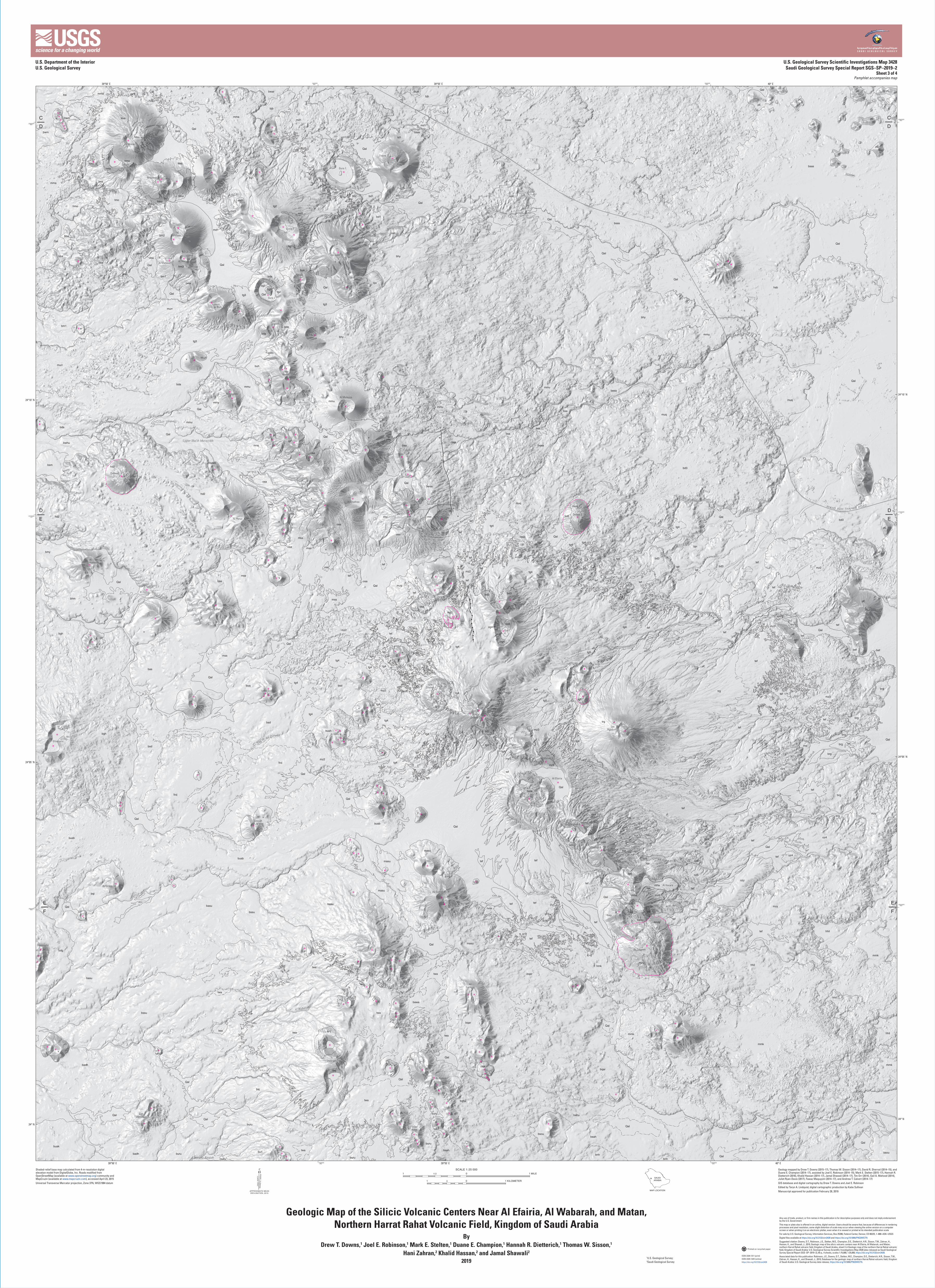
Geologic Map of the Silicic Volcanic Centers Near Al Efairia, Al Wabarah, and Matan, Northern Harrat Rahat Volcanic Field, Kingdom of Saudi Arabia
ByDrew T. Downs,1 Joel E. Robinson,1 Mark E. Stelten,1 Duane E. Champion,1 Hannah R. Dietterich,1 Thomas W. Sisson,1
Hani Zahran,2 Khalid Hassan,2 and Jamal Shawali2
20191U.S. Geological Survey;2Saudi Geological Survey
Any use of trade, product, or firm names in this publication is for descriptive purposes only and does not imply endorsement by the U.S. Government
This map or plate also is offered in an online, digital version. Users should be aware that, because of differences in rendering processes and pixel resolution, some slight distortion of scale may occur when viewing the online version on a computer screen or when printing it on an electronic plotter, even when it is viewed or printed at its intended publication scale
For sale by U.S. Geological Survey, Information Services, Box 25286, Federal Center, Denver, CO 80225, 1–888–ASK–USGS
Digital files available at https://doi.org/10.3133/sim3428 and https://doi.org/10.5066/P9Q3WGTN
Suggested citation: Downs, D.T., Robinson, J.E., Stelten, M.E., Champion, D.E., Dietterich, H.R., Sisson, T.W., Zahran, H., Hassan, K., and Shawali, J., 2019, Geologic map of the silicic volcanic centers near Al Efairia, Al Wabarah, and Matan, northern Harrat Rahat volcanic field, Kingdom of Saudi Arabia, sheet 3 in Geologic map of the northern Harrat Rahat volcanic field, Kingdom of Saudi Arabia: U.S. Geological Survey Scientific Investigations Map 3428 [also released as Saudi Geological Survey Special Report SGS–SP–2019–2], 65 p., 4 sheets, scales 1:75,000, 1:25,000, https://doi.org/10.3133/sim3428.
Associated data for this publication: Robinson, J.E., Downs, D.T., Stelten, M.E., Champion, D.E., Dietterich, H.R., Sisson, T.W., Zahran, H., Hassan, K., and Shawali, J., 2019, Database for the geologic map of northern Harrat Rahat volcanic field, Kingdom of Saudi Arabia: U.S. Geological Survey data release, https://doi.org/10.5066/P9Q3WGTN.
Printed on recycled paper
ISSN 2329-1311 (print)ISSN 2329-132X (online)https://doi.org/10.3133/sim3428
Shaded-relief base map calculated from 4-m-resolution digital elevation model from DigitalGlobe, Inc. Roads modified from OpenStreetMap (available at www.openstreetmap.org) community and MapCruzin (available at www.mapcruzin.com), accessed April 23, 2015Universal Transverse Mercator projection, Zone 37N, WGS1984 datum
Geology mapped by Drew T. Downs (2015–17), Thomas W. Sisson (2014–17), David R. Sherrod (2014–15), and Duane E. Champion (2014–17), assisted by Joel E. Robinson (2014–15), Mark E. Stelten (2015–17), Hannah R. Dietterich (2016), Khalid Hassan (2014–17), Jamal Shawali (2014–17), Tim Orr (2014), Gail A. Mahood (2014), Juliet Ryan-Davis (2017), Fawaz Maquyyim (2014–17), and Andrew T. Calvert (2014–17)GIS database and digital cartography by Drew T. Downs and Joel E. RobinsonEdited by Taryn A. Lindquist; digital cartographic production by Katie SullivanManuscript approved for publication February 28, 2019MAP LOCATION
SAUDIARABIA
U.S. Department of the InteriorU.S. Geological Survey
U.S. Geological Survey Scientific Investigations Map 3428Saudi Geological Survey Special Report SGS–SP–2019–2
Sheet 3 of 4Pamphlet accompanies map