geological and geotechnical report … - geological and... · geological and geotechnical...
TRANSCRIPT
ENVIRONMENTAL IMPACT STATEMENT
APPENDIX
QGEOLOGICAL AND GEOTECHNICAL REPORT

Gold Coast Quarry
Geological and Geotechnical ExplorationProgram, Resource Estimate and ConceptualQuarry DesignPrepared for:Boral Resources (Queensland) Pty Limited
Date: April 2013
File Ref: 1454_220_001

Gold Coast QuarryGeological and Geotechnical Exploration Program, Resource Estimate and Conceptual Quarry Design
Document Control
April 2013 / file ref.1454_220_001_Ver1
Page i
Job Details
Ref no.: 1454_220_001
Version: 1
Document Title: Geological and Geotechnical Exploration Program, Resource Estimate and Conceptual QuarryDesign
Principal Author: Rod Huntley
Client: Boral Resources (Queensland) Pty Ltd/Cardno HRP
Document StatusVersion Description Date Author Reviewer
1 Geological and Geotechnical Exploration Program,Resource Estimate and Conceptual Quarry Design April 2013 Rod Huntley JEH
Distribution Record# Copies (electronic / hardcopy)Destination Draft 1 Draft 2 V1 V2 V3 V4
Cardno HRP 1E 1E 2EBoral Resources (Queensland) PtyLimited 1E 1E 1E
Copyright ©These materials or parts of them may not be reproduced in any form, by any method, for any purpose except with written permission from Groundwork Plus.

Gold Coast QuarryGeological and Geotechnical Exploration Program, Resource Estimate and Preliminary Quarry Design
Table of Contents
April 2013 / file ref.1454_220_001_Ver1
Page ii
Disclaimer .............................................................................................................................................................................1
Executive Summary ............................................................................................................................................................3
1. Introduction ...............................................................................................................................................................181.1 The Proponent .......................................................................................................................................................181.2 The Project.............................................................................................................................................................181.3 The Site..................................................................................................................................................................20
1.3.1 Location and Contextual Setting ..................................................................................................................201.3.2 Site Area ......................................................................................................................................................201.3.3 Current Use..................................................................................................................................................211.3.4 Land Tenure and Native Title.......................................................................................................................211.3.5 Road Frontage and Vehicular Access..........................................................................................................211.3.6 The Assessment Process ............................................................................................................................21
1.4 Scope of Work........................................................................................................................................................221.4.1 The Design Brief ..........................................................................................................................................221.4.2 Terms of Reference .....................................................................................................................................24
2. Geology ......................................................................................................................................................................252.1 Regional Geology...................................................................................................................................................25
2.1.1 Main Rock Types of the Neranleigh Fernvale Beds.....................................................................................262.2 Site Geology...........................................................................................................................................................28
2.2.1 Meta-greywacke/Greywacke........................................................................................................................282.2.2 Bouma Sequences.......................................................................................................................................292.2.3 Meta-Siltstone/Argillite .................................................................................................................................31
3. Exploration Work ......................................................................................................................................................323.1 Previous Investigations 1999-2011........................................................................................................................323.2 2012 Exploration Campaign...................................................................................................................................34
4. Results of Geological Investigations.....................................................................................................................364.1 Drill Results............................................................................................................................................................36
4.1.1 Core Orientations.........................................................................................................................................364.2 Petrology................................................................................................................................................................384.3 Material Testwork Results......................................................................................................................................384.4 Resource Model Nomenclature and Files..............................................................................................................41
4.4.1 Surpac General Files ...................................................................................................................................414.4.2 Surpac Surface Files....................................................................................................................................414.4.3 Block Model Files.........................................................................................................................................42
4.5 Geology Model.......................................................................................................................................................444.6 Depth of Weathering ..............................................................................................................................................444.7 Resource Significance ...........................................................................................................................................454.8 Resource Estimate.................................................................................................................................................454.9 Criteria Used in Resource Estimation ....................................................................................................................464.10 Assumptions and Parameters...........................................................................................................................514.11 Resource Classification.....................................................................................................................................514.12 Database Validation..........................................................................................................................................53

Gold Coast QuarryGeological and Geotechnical Exploration Program, Resource Estimate and Preliminary Quarry Design
Table of Contents
April 2013 / file ref.1454_220_001_Ver1
Page iii
5. Geotechnical Investigations ...................................................................................................................................535.1 Project Setting........................................................................................................................................................535.2 West Burleigh Quarry Geotechnical Review..........................................................................................................545.3 Old Coach Road.....................................................................................................................................................585.4 Helensvale Cutting Geotechnical Review ..............................................................................................................605.5 Rock Properties......................................................................................................................................................645.6 Core Drilling 2012 ..................................................................................................................................................64
5.6.1 Orientation Data...........................................................................................................................................645.6.2 Rock Quality Designation.............................................................................................................................655.6.3 Joint Conditions............................................................................................................................................665.6.4 Rock Mass Rating (Bieniawski)....................................................................................................................695.6.5 Geotechnical Domains.................................................................................................................................70
6. Slope Design .............................................................................................................................................................716.1 Limit Equilibrium Modelling ....................................................................................................................................72
6.1.1 Modelling Criteria .........................................................................................................................................726.1.2 Stage Q1 Limit Equilibrium Stability Assessment ........................................................................................736.1.3 Stage Q2 Limit Equilibrium Stability Assessment ........................................................................................756.1.4 Stage Q3 Limit Equilibrium Stability Assessment ........................................................................................776.1.5 Stage Q4 Limit Equilibrium Stability Assessment ........................................................................................796.1.6 Stage Q5 Limit Equilibrium Stability Assessment ........................................................................................82
6.2 Benchmarking Slope Design..................................................................................................................................906.3 Gold Coast Council Geotechnical Mapping ...........................................................................................................916.4 Geotechnical Risk Rating.......................................................................................................................................92
7. Risk Analysis.............................................................................................................................................................937.1 Overview of Risk Management ..............................................................................................................................937.2 General Risk Management Process ......................................................................................................................947.3 Risk Management in Extractive Industry................................................................................................................987.4 Risk Assessment Findings.....................................................................................................................................99
8. Recommendations....................................................................................................................................................99
9. JORC Reporting Checklist ................................................................................................................................... 1009.1 Check List and Reporting Criteria ........................................................................................................................100
9.1.1 Drilling Technique ......................................................................................................................................1009.1.2 HQ and Drill Sample Recovery ..................................................................................................................1009.1.3 Logging ......................................................................................................................................................1009.1.4 Sub-sampling Techniques and Sample Preparation..................................................................................1009.1.5 Quality of Assay Data and Laboratory Tests..............................................................................................1009.1.6 Verification of Sampling and Assaying.......................................................................................................1009.1.7 Location of Data Points..............................................................................................................................1009.1.8 Data Spacing and Distribution....................................................................................................................1009.1.9 Orientation of Data in Relation to Geological Structure..............................................................................1009.1.10 Mineral Tenements and Land Tenure Status.............................................................................................1009.1.11 Exploration Done by Other Parties.............................................................................................................1019.1.12 Geology......................................................................................................................................................1019.1.13 Further Work ..............................................................................................................................................1019.1.14 Database Integrity......................................................................................................................................101

Gold Coast QuarryGeological and Geotechnical Exploration Program, Resource Estimate and Preliminary Quarry Design
Table of Contents
April 2013 / file ref.1454_220_001_Ver1
Page iv
9.1.15 Geological Interpretation............................................................................................................................1019.1.16 Estimation and Modelling Techniques .......................................................................................................1019.1.17 Moisture .....................................................................................................................................................1019.1.18 Bulk Density ...............................................................................................................................................1019.1.19 Classification..............................................................................................................................................1019.1.20 Cut-off Parameters.....................................................................................................................................1039.1.21 Audits or Reviews ......................................................................................................................................103
10. Important Information..................................................................................................................................... 103
References....................................................................................................................................................................... 104
Glossary of Terms .......................................................................................................................................................... 105
List of TablesTable TitleTable 1 Gold Coast Quarry JORC Resource SummaryTable 2 Drill Hole Summary 1999Table 3 Drill Hole Summary 2004Table 4 Drill Hole Summary 2005 Core DrillingTable 5 Drill Hole Summary 2012 Piezometer DrillingTable 6 Drill Hole Summary 2012 Percussion DrillingTable 7 Drill Hole Summary 2012 Core DrillingTable 8 Historical Material Test Work Results SummaryTable 9 2012 Material Test Work Results SummaryTable 10 Specification Limits Summary (Source Material Group Metamorphic)Table 11 Bench Volume ReportTable 12 JORC Resource CategoriesTable 13 JORC 2004 Resource DiagramTable 14 Stage VolumesTable 15 Rock PropertiesTable 16 Small Scale Roughness CriterionTable 17 RMR Calibrated Against Rock Mass QualityTable 18 Bieniawski 1976 RMR Parameter RatingsTable 19 Slope Design Guidelines

Gold Coast QuarryGeological and Geotechnical Exploration Program, Resource Estimate and Preliminary Quarry Design
Table of Contents
April 2013 / file ref.1454_220_001_Ver1
Page v
FiguresFigure Title Drawing No.Figure 1 Site Location plan 1454.029Figure 2 Phase C2 Construction Works Crushing Plant 100% Complete 1454.034r1Figure 3 Phase Q1 Quarry Operations Extraction and Schematic Layout 1454.016r2Figure 4 Phase Q1 Quarry Operations Extraction and Schematic Layout 1454.021r2Figure 5 Phase Q1 Quarry Operations Extraction and Schematic Layout 1454.024r3Figure 6 Phase Q1 Quarry Operations Extraction and Schematic Layout 1454.026r3Figure 7 Phase Q1 Quarry Operations Extraction and Schematic Layout 1454.027r2Figure 8A Total Slope Angles – Phase Q1 1454.047r1Figure 8B Total Slope Angles – Phase Q2 1454.048r1Figure 8C Total Slope Angles – Phase Q3 1454.049r1Figure 8D Total Slope Angles – Phase Q4 1454.050r1Figure 8E Total Slope Angles – Phase Q5 1454.051r1Figure 9 Drill Hole Summary 1454.046Figure 10A Geotechnical Risk Rating Map – Phase Q1 1454.040r1Figure 10B Geotechnical Risk Rating Map – Phase Q2 1454.041r1Figure 10C Geotechnical Risk Rating Map – Phase Q3 1454.042r1Figure 10D Geotechnical Risk Rating Map – Phase Q4 1454.043r1Figure 10E Geotechnical Risk Rating Map – Phase Q5 1454.044r1Figure 11 Environmental Constraints 1454.011Figure 12 Site Cadastre 1454.038Figure 13 Aerial Photo and Topography 1454.017Figure 14 Regional Geology 1454.004Figure 15 Site Geology 1454.030Figure 16 Drill Hole Location Plan 1454.015r1Figure 17A Cross Section A-A' 1454.025AFigure 17B Cross Section B-B' 1454.025BFigure 17C Cross Section C-C' 1454.025CFigure 17D Cross Section D-D' 1454.025DFigure 17E Cross Section E-E' 1454.025EFigure 18A Overburden Isopach Map 1454.018Figure 18B Distinctly Weathered Isopach Map 1454.022Figure 18C Slightly Weathered Isopach Map 1454.023Figure 19 Geotechnical Data Points 1454.045Figure 20 Geotechnical Domains 1454.032r1Figure 21 Areas of Unstable Soils and Areas of Potential Land Slip Hazard Overlay Map 1454.033
AppendicesAppendix TitleAppendix 1 Geochempet Petrographic ReportsAppendix 2 Historical Material Testwork ResultsAppendix 3 2012 Percussion Drilling ReportAppendix 4 2012 Drill hole Photographs and LogsAppendix 5 2012 Material Testwork ResultsAppendix 6 Orishot ManualAppendix 7 Understanding Your Geological ReportAppendix 8 Digital Data

Gold Coast QuarryGeological and Geotechnical Exploration Program, Resource Estimate and Preliminary Quarry Design
April 2013 / file ref.1454_220_001_Ver1
Page 1
DisclaimerThis report and all its components (including images, audio, video, and text) are copyright. Apart from fair dealing forthe purposes of private study, research, criticism, or review as permitted under the Copyright Act 1968, no part maybe reproduced, copied, or transmitted in any form, or by any means (electronic, mechanical or graphic) without theprior written permission of Groundwork Plus.
This report has been prepared for the sole use of Cardno HRP and Boral Resources (Queensland) Pty Ltd (herein,'the clients'), for the Gold Coast Quarry (herein 'the site'), for the specific purpose of this report (herein 'the purpose').This report is strictly limited for use by the client to the purpose and site, and may not be used for any otherpurposes.
Third parties, excluding regulatory agencies assessing an application in relation to the purpose, may not rely on thisreport without prior consent. Groundwork Plus waives all liability to any third party loss, damage, liability or claimarising out of or incidental to a third party publishing, using or relying on the facts, content, opinions or subject mattercontained in this report.
Groundwork Plus waives all responsibility for loss or damage where the accuracy and effectiveness of informationprovided by the Client or other third parties was inaccurate and was relied upon, wholly or in part in reporting.
For further information understanding this report refer to APPENDIX 7.
Gold Coast QuarryGeological and Geotechnical Exploration Program, Resource Estimate and Preliminary Quarry Design
April 2013 / file ref.1454_220_001_Ver1
Page 2
Statement
I,……………………………………………Rodney Hall Huntley …………………………………confirm that:
I am the Competent Person for the Gold Coast Quarry reporting of Minerals Resources.
· I have read and understood the requirements of the 2012 Edition of the Australasian Code for Reporting ofExploration Results, Mineral Resources and Ore Reserves (“2012 JORC Code”).
· I am a Competent Person as defined by the 2012 JORC Code, having more than five years experience which isrelevant to the style of mineralisation and type of deposit described in the Report, and to the activity for which Iam accepting responsibility.
· I am a Member or Fellow of The Australasian Institute of Mining and Metallurgy or the Australian Institute ofGeoscientists or a ‘Recognised Overseas Professional Organisation’ (“ROPO”) included in a list promulgated byASX from time to time.
· I have written and reviewed the Report to which this Consent Statement applies.
I am a consultant working for Groundwork Plus and have been engaged by Boral Resources (Queensland) Pty Ltd toprepare the documentation for the Gold Coast Quarry which provides the basis for the reporting of MineralResources and which the Report is based, for the period ended October 2012.
I verify that the Report is based on and fairly and accurately reflects in the form and context in which it appears, theinformation in my supporting documentation relating to Exploration Results and Mineral Resources.
Consent
I consent to the release of the Report and this Consent Statement by the directors of:
Boral Resources (Queensland) Pty Ltd
29 November 2012__________________________________________ _____________________________________Signature of Competent Person: Date:
Australian Institute of Geoscientists 3368__________________________________________ _____________________________________Professional Membership: Membership Number:

Gold Coast QuarryGeological and Geotechnical Exploration Program, Resource Estimate and Preliminary Quarry Design
April 2013 / file ref.1454_220_001_Ver1
Page 3
Executive SummaryGroundwork Plus was commissioned by Cardno HRP and Boral Resources (Queensland) Pty Limited to complete acomprehensive geological and geotechnical investigation for the proposed Gold Coast Quarry refer FIGURE 1 –SITE LOCATION PLAN. As part of this work 43 percussion holes and five deep orientated core holes were drilledand integrated into the existing geological and geotechnical database. This comprehensive database was thencombined with field mapping data, petrology and materials testing to provide a robust foundation for development ofthe geological and geotechnical model. This work was completed with a high degree of collaborative and technicalinput from the Boral Resources Technical Services Team. Resultant of this work a revised and updated geologicalmodel and JORC compliant resource estimate was completed, with this work defining a total resource existing in thepit area of approximately 72.9 million tonnes, refer TABLE 1. In addition to the pit resource an additional resource inthe pre works infrastructure area exists which consists of approximately 6 million tonnes.
TABLE 1 – GOLD COAST QUARRY JORC RESOURCE SUMMARY*
VOLUME INSITU TONNES INSITUDEVELOPMENT PHASE
MILLION m3 MILLION t/m3
Q1 2.05 4.98Q2 4 10.14Q3 9.73 25.41Q4 17.13 45.21Q5 27.42 72.9
Pit Total** 27.42 72.9*A full breakdown of volumes per stage and bench along with material classification, category and status is provided in Section 4.8 ** Refer FIGURE 8. All figuresapart from the pit total are cumulative. Also under site earthworks 130,000 m3 will be sourced from the plant stockpile area.
To further refine development of the project, and to aid assessment of environmental impacts of the project, a seriesof development phases were generated. As part of the quarry design process, multiple permutations on quarrydevelopment were considered, however for consistency and certainty, the final development concept utilised wasprovided by Boral Resources.
In the various development options reviewed, consideration of environmental and, in particular, conservation andamenity issues has exerted a large influence on the design of the quarry development plans. In particular this quarrywill be developed, in so far as is practicable, to co exist and minimise disruption to the more ecologically sensitiveareas on site, including the biodiversity hot spot in the south eastern sector of the site which hosts Durobby,(Syzygium moorei), the Minute Orchid, (Taeniophyllum muelleri), a colony of Long Leaved Tuckeroo, (Cupaniosis
newmanii), and also plays host to the White Bellied Sea Eagle. Accordingly this area will be retained in the buffer.
Gold Coast QuarryGeological and Geotechnical Exploration Program, Resource Estimate and Preliminary Quarry Design
April 2013 / file ref.1454_220_001_Ver1
Page 4
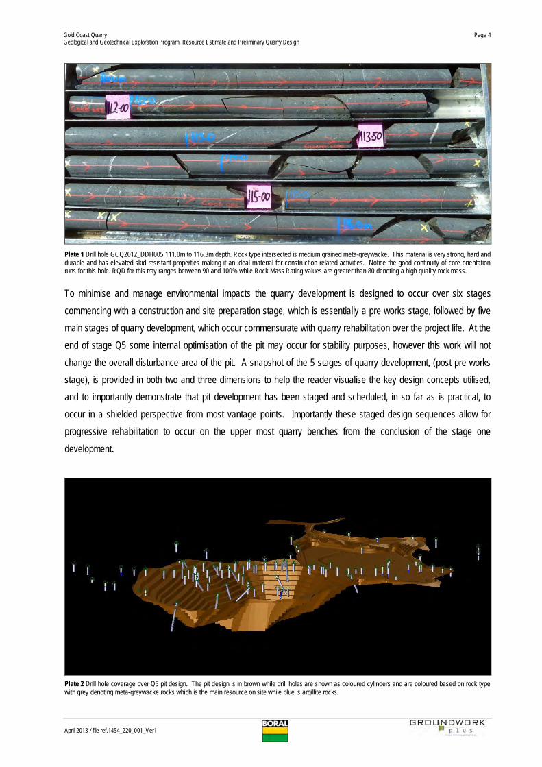
Plate 1 Drill hole GCQ2012_DDH005 111.0m to 116.3m depth. Rock type intersected is medium grained meta-greywacke. This material is very strong, hard anddurable and has elevated skid resistant properties making it an ideal material for construction related activities. Notice the good continuity of core orientationruns for this hole. RQD for this tray ranges between 90 and 100% while Rock Mass Rating values are greater than 80 denoting a high quality rock mass.
To minimise and manage environmental impacts the quarry development is designed to occur over six stagescommencing with a construction and site preparation stage, which is essentially a pre works stage, followed by fivemain stages of quarry development, which occur commensurate with quarry rehabilitation over the project life. At theend of stage Q5 some internal optimisation of the pit may occur for stability purposes, however this work will notchange the overall disturbance area of the pit. A snapshot of the 5 stages of quarry development, (post pre worksstage), is provided in both two and three dimensions to help the reader visualise the key design concepts utilised,and to importantly demonstrate that pit development has been staged and scheduled, in so far as is practical, tooccur in a shielded perspective from most vantage points. Importantly these staged design sequences allow forprogressive rehabilitation to occur on the upper most quarry benches from the conclusion of the stage onedevelopment.
Plate 2 Drill hole coverage over Q5 pit design. The pit design is in brown while drill holes are shown as coloured cylinders and are coloured based on rock typewith grey denoting meta-greywacke rocks which is the main resource on site while blue is argillite rocks.

Gold Coast QuarryGeological and Geotechnical Exploration Program, Resource Estimate and Preliminary Quarry Design
April 2013 / file ref.1454_220_001_Ver1
Page 5
Q1 DEVELOPMENT AERIAL VIEW
DIAGRAM 1 Q1 development with the quarry developing westerly. Left of page is east. Pink is processing plant and stockpile infrastructure while yellow text and cylinders denote drill hole locations and rock type. Notice the encirclingridgelines which clearly shield nearby houses and provide a large environmental buffer to the quarry operations. The property boundary is shown in yellow. The nearest house is circa 270 metres away denoted by the red arrow.

Gold Coast QuarryGeological and Geotechnical Exploration Program, Resource Estimate and Preliminary Quarry Design
April 2013 / file ref.1454_220_001_Ver1
Page 6
Q1 DEVELOPMENT PLAN VIEW (EXCERPT FROM FIGURE 3)
DIAGRAM 2 Q1 development with the quarry developing toward the west away from the majority of nearby sensitive receptors. Top of page is north. Dots denote drill hole locations and orientations. Multiple development orientations exist forquarry development which will allow for flexibility in mitigating any impacts if required. The maximum proposed extraction footprint is illustrated by the yellow dotted line. The KRA boundary is purple.

Gold Coast QuarryGeological and Geotechnical Exploration Program, Resource Estimate and Preliminary Quarry Design
April 2013 / file ref.1454_220_001_Ver1
Page 7
STAGE 2 DEVELOPMENT AERIAL VIEW
DIAGRAM 3 Q2 continuing development within the quarry mainly at depth in the western sector of the site. Left of page is east.