geological report on kamiskotia property robb … · geological report on kamiskotia property robb...
TRANSCRIPT
C VON HESKE RT, CONSULTING GtOLOGIS l
i',42A12SE025t 2.5930 ROBB
010
GEOLOGICAL REPORT ON
KAMISKOTIA PROPERTY
ROBB TOWNSHIP
Porcupine Mining Division
Ontario
September 23, 1983
i-
C. von Ilessert S Associates 49 Wellington Street East First Floor Toronto, Ontario M5K 1C9
Tel: (416) 863-6796
R.M. Sproule Geo!og i st

C VON HESS-ERT. CONSULTING GEOLOGIST
42A12SE0251 2.5930 ROBB 010C
TABLE OF CONTENTS
Page
1.
2.
3.
4.
5.
6.
7.
Summary
Property Description and Location
Property Location Map
Work History
Line Cutting
Geological Survey
Conclusions
Recommendations
6
6
References
Schedule I
Assessment Due Dates
Appendix - Certificate of Analyses
Maps in Back Pocket
1) Claim Map, Robb Township 1: 31680
2) Geology Kamiskotia Claim Group 1:2500
C. VON HESSERT, CONSULTING GEOLOGIST
1. SUMMARY
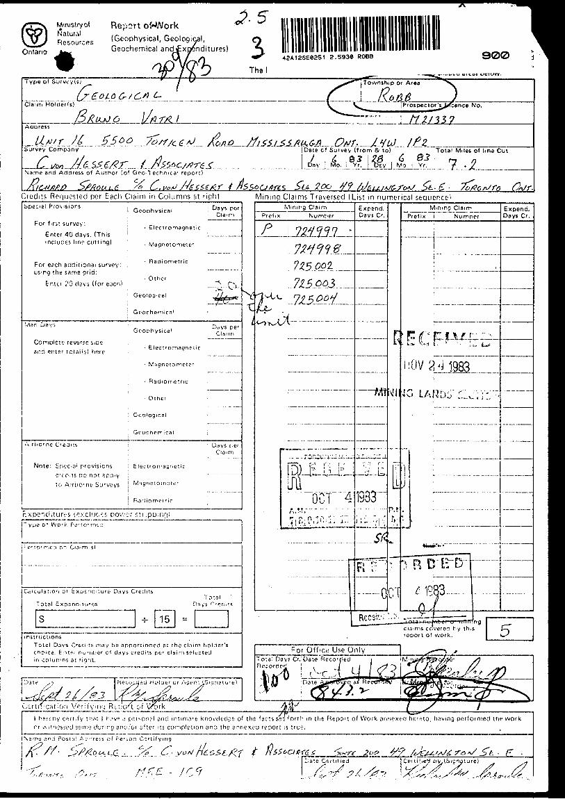
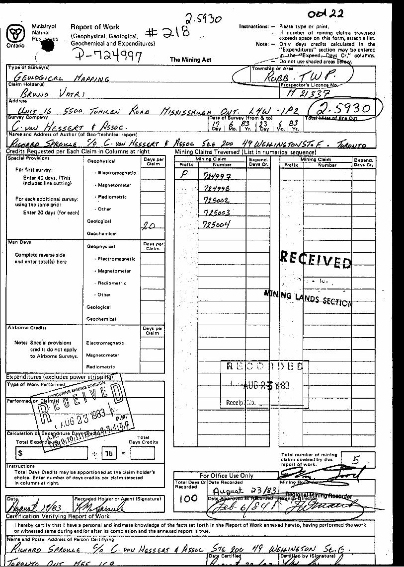
The Kamiskotia property consists of five contiguous unpatented claims located 36 kilometers by road northwest of Timmins in Robb Township. Work commenced on these claims on June l and was completed by June 28, 1983. This work was comprised of line cutting, geological mapping and sampling. Results of the mapping indicate the ground is underlain by intermediate volcanics and gabbro of Archean age. A single high assay of 0.15 ounces of gold per ton taken from an intermediate volcanic rock in the course of mapping indicates that the property has economic potential. Additional work is recommended.
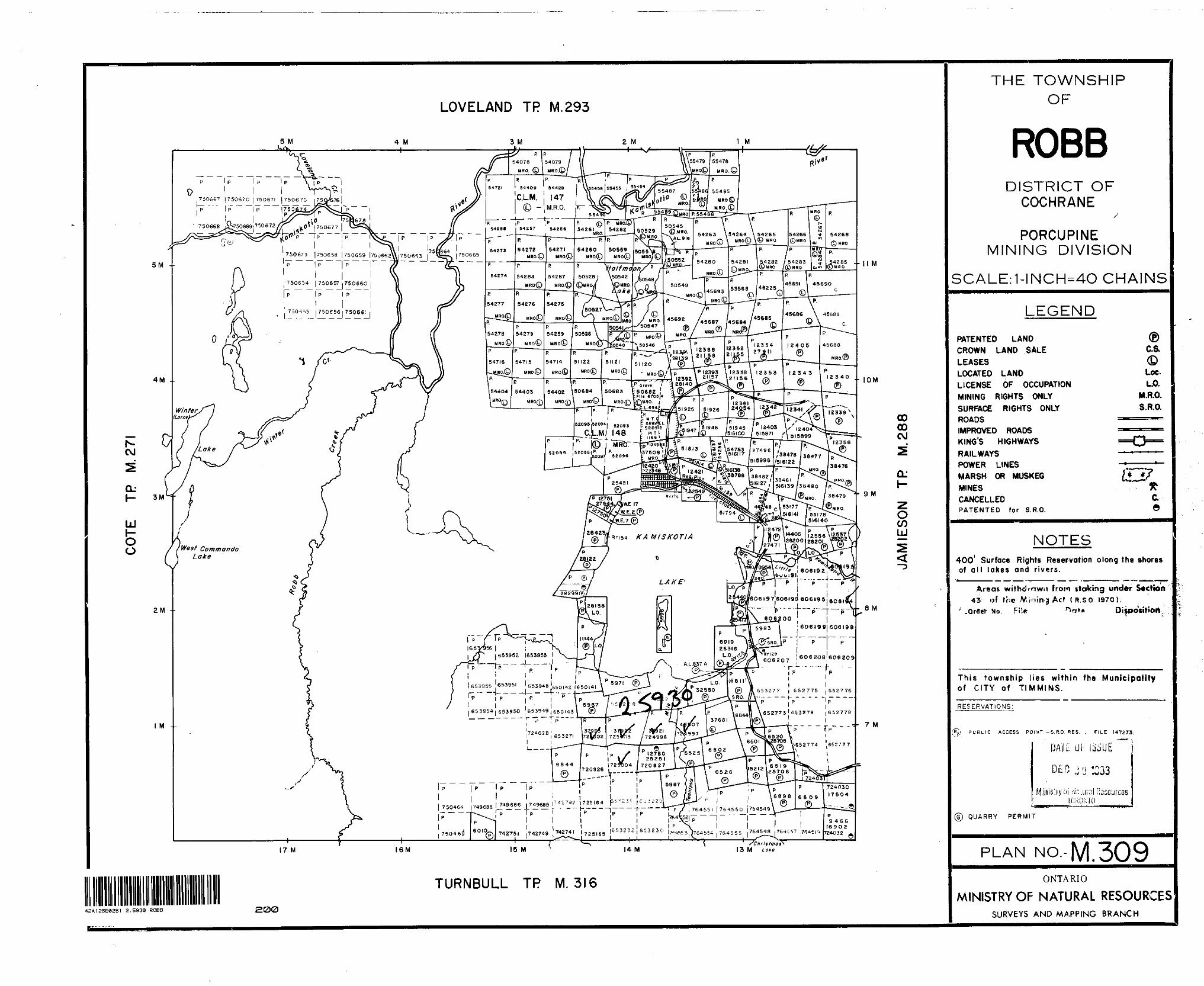
2. PROPERTY DESCRIPTION AND LOCATION
The property is made up of a group of 5 contiguous unpatented mining claims in Robb township in the Porcupine Mining Division, District of Cochrane, Ontario (see Figure 1).
The claims are numbered as below: P724997 - 724998 P725002 - 755004
Access to the property is gained via paved Highway 576 which leads north to Kamiskotia Lake, 26 kilometers distant from Highway 101. (Map 1)
The title holder of the property is Mr. Bruno Vatri of Mississauga, Ontario.
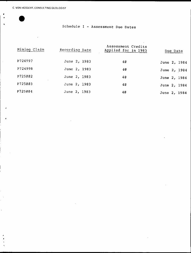
Schedule l, included 'with the appendix, lists the recording date and the status of each claim with respect to impending deadlines for assessment work submissions.
- l -
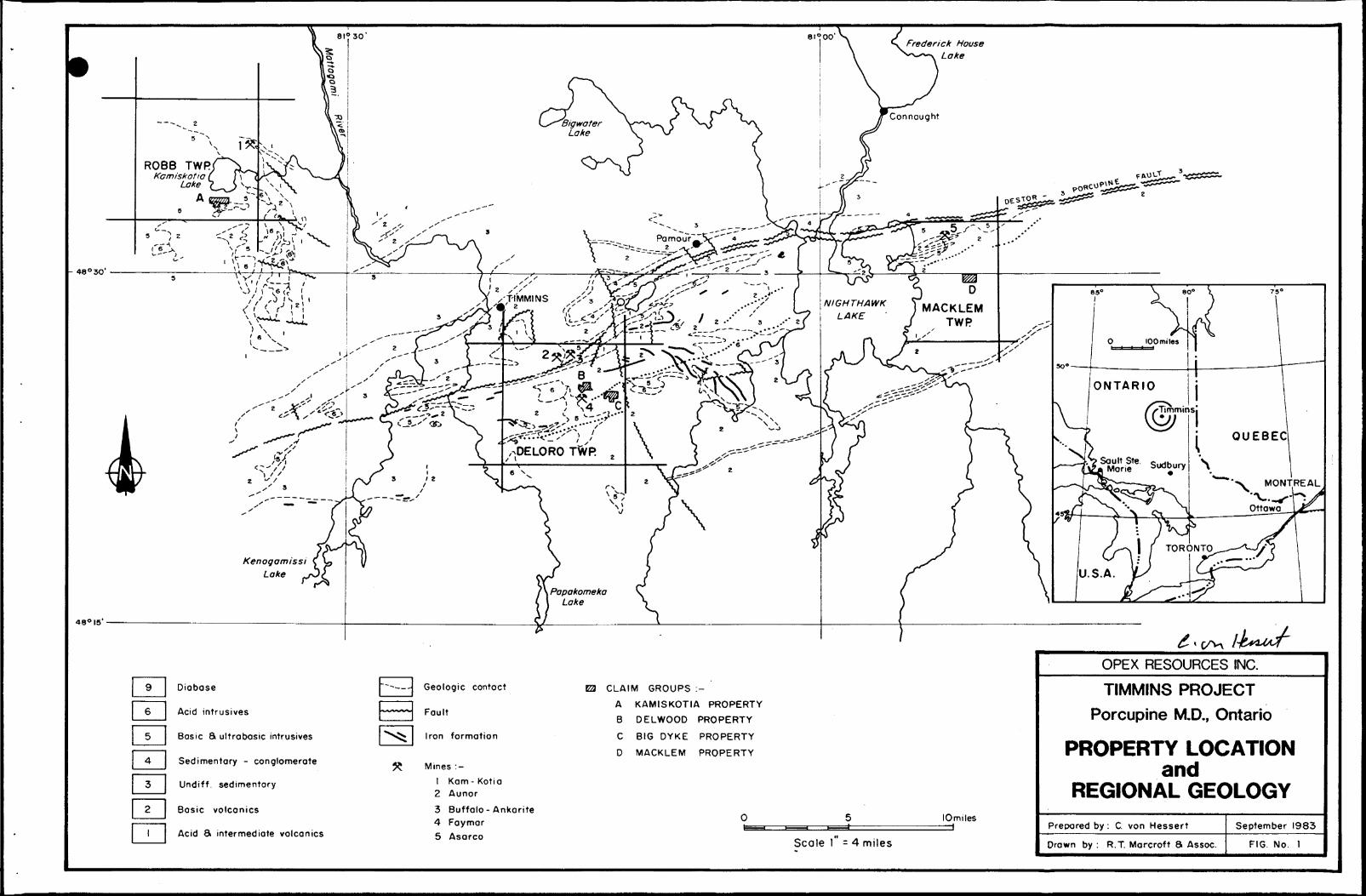
- 48 0 30
480 I5
Frederick House Lake
ROBB TWRKamiskotia
Lake
9 Diobose
6 l Acid intrusives
Basic ft ultrobosic intrusives
Sedimentary - conglomerate
Undiff. sedimentary
Basic volcanics
Acid S intermediate volcanics
Geologic contact
Fault
Iron formation
Mines :-
1 Kam- Kotia2 Aunor
3 Buffalo - Ankerite4 Faymar
5 Asarco
CLAIM GROUPS :-
A KAMISKOTIA PROPERTY
B DELWOOD PROPERTY
C BIG DYKE PROPERTY
D MACKLEM PROPERTY
lOmiles
Scale l - 4 miles
OPEX RESOURCES INC.
TIMMINS PROJECT
Porcupine M.D., Ontario
PROPERTY LOCATIONand
REGIONAL GEOLOGY
Prepared by : C. von Hessert
Drown by : R.T. Marcroft 8 Assoc.
September 1983
FIG. No. 1

C VON HESSERT. CONSULTING GEOLOGIST
3. WORK HISTORY
The area was first traversed by gold prospectors in the early 1900's. In the mid 1920's Hollinger Consolidated Gold Mines sank a shaft at the site of the old Kam-Kotia Mine (a base metal producer). Homestake Mining and New Walcoro Gold Mines carried out the first organized gold exploration in the direct vicinity of the Vatri Kamiskotia property.
The following is a list of companies and a summary of the work carried out by them in the vicinity of the Kamiskotia Property.
HOMESTAKE MINING - 1924
Hill-Haggquist prospect south of Kamiskotia Lake(currently covered by claim P725003).Minor visible gold in quartz stringers in graniticintrusive.Channel sampling - no available data.
NEW WALCORO MINES LIMITED
Magnetic survey and geology by Young, Young fc Gross -1949 (W.H. Gross).BL E-W, PL N-NW @ 300 ft.: 13.5 miles.Mag. Sharpe-Schmidt type.Geology - gabbro, pegmatitic; minor rhyolite off south-
west corner of property (currently covered by patented claim P.6010).
Trenching - pre-1949 - auriferous quartz vein in carbonate shear zone - no assay data.
Drilling - pre-1949 - 18 holes to intersect quartz vein; on claim P.31360 (currently P.628816). Gold up to 0.17 oz/ton across 9 ft.
Remarks: Quartz vein in shear carries to the west.
MINING CORPORATION - 1946
Geology - (N. Hogg?) - l in. = 400 ft.PL N-S.Mag. Vertical Component Variometer.Drilling - one hole bearing south located approximately
1/4 mile south-west of Christmas Lake on south-east corner of P.33460; one hole on north boundary of claim P.30286 about 1/2 mile north-east of Christmas Lake.Holes penetrated quartz porphyry, andesite, gabbro, rhyolite and rhyolite fragmental, diabase. No report available.
- 2 -
C. VON HESSERT, CONSULTING GEOLOGIST
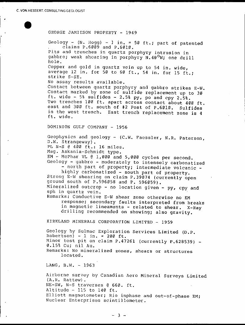
GEORGE JAMIESON PROPERTY - 1949
Geology - {N. Hogg) - l in. * 5 0 ft.; part of patentedclaims P.6009 and P.6010.
Pits and trenches in quartz porphyry intrusion in gabbro; weak shearing in porphyry N.40 OW; one drill hole.Copper and gold in quartz vein up to 54 in. wide, average 12 in. for 50 to 60 ft., 54 in. for 15 ft.; strike S-SE.No assay results available.Contact between quartz porphyry and gabbro strikes E-W. Contact marked by zone of sulfide replacement up to 30 ft. wide - 51 sulfides - 2.51 py, po and cpy 2.51. Two trenches 100 ft. apart across contact about 400 ft. east and 300 ft. south of #2 Post of P.6010. Sulfides in the west trench. East trench replacement zone is 4 ft. wide.
DOMINION GULF COMPANY - 1956
Geophysics and geology - (C.W. Faessler, N.R. Paterson,D.W. Strangeway).PL N-S @ 400 ft.: 16 miles.Mag. Askania-Schmidt type.EM - McPhar VL @ 1,000 and 5,000 cycles per second.Geology - gabbro - moderately to intensely carbonatized
- north part of property; intermediate volcanic - highly carbonatized - south part of property.
Strong E-W shearing on claim P.39074 (currently openground south of P.596058 and P. 596059).Mineralized outcrop - no location given - py, cpy andsph in quartz vein.Remarks: Conductive E-W shear zone otherwise no EM
response; secondary faults interpreted from breaks in magnetic lineaments - related to shear. X-Ray drilling recommended on showing; also gravity.
KIRKLAND MINERALS CORPORATION LIMITED - 1 959
Geology by Sulmac Exploration Services Limited (D.P. Robertson) - l in. = 200 ft.Minor test pit on claim P.47261 (currently P.628539) - 0.151 Cu; nil Au.Remarks: No mineralized zones, shears or structures
located.
LANG, B.W. - 1963
Airborne survey by Canadian Aero Mineral Surveys Limited (A.R. Rattew).NE-SW, N-S traverses @ 660. ft. Altitude - 115 to 140 ft.Elliott magnetometer; Rio inphase and out-of-phase EM; Nuclear Enterprises scintillometer.
- 3 -
C. VON HESSERT. CONSULTING GEOLOGIST
MESPI MINES LIMITED - 1 964
Airborne survey by Hunting Survey Corporation {R.N.Parkinson).E-W traverses @ 660 ft.Terrain clearance - 450 to 500 ft.Gulf magnetometer; Canadian Applied Research dualfrequency EM - 400 and 2,300 cycles per second.
Ground survey work - (L.K. Lytle, W.E. Nyman).PL N-S @ 400 ft.: 55 miles.EM - Crone dual frequency transceiver, coil separation300 ft.Remarks: No conductors.
KAYJON MINERALS LIMITED - 1966
Geophysics by Chew-Walker Associates and GeotechnicalDevelopment Company Limited (W. Walker).PL NE-SW: 17.7 miles.Mag. Sharpe A-2.EM - Sharpe S.E.200 VLF; McPhar (R.E.M.) - 1,000 to
5,000 cps, 200 ft. coil separation. Remarks: B horizon soil sampling for Ni analyses
recommended.
Geochemical and geological survey by Barringer ResearchLimited (J.L. Walker).Soil Sampling - Ni analysis.Remarks: No anomalies - soils are transported.
NORANDA EXPLORATION COMPANY LIMITED - 1 968
BL E-W for 6,000 ft.; PL @ 400 ft. over 12 claims - (E.A. Gallo).Mag. Sharpe MF-1 Fluxgate.EM - McPhar VLEM dual frequency - Tx and Rx. Remarks: 3 conductive zones; l possible bedrock source.
AMAX EXPLORATION LIMITED - 1969, 1971
Geophysics - (J.L. Kirwan; J. Roth). PL N-S over 6 claims - covers Christmas Lake. Mag. Askania.Remarks: No information of direct economic value appears
to be located by the magnetic survey.
EM - McPhar VLEM @ 1,000 and 5,000 Hz.Remarks: Shape and amplitude of crossovers indicate 2
possible interpretations (1) a wide, deep seated conductor; or (2) a broad, surficial conductor of low conductivity. In view of the fact that the area is essentially devoid of outcrop and that conductive overburden conditions are prevalent, the latter interpretation is preferred.

C. VON HESSERT, CONSULTING GEOLOGIST
TURNBULL SYNDICATE - 1970
Geophysics and drilling by P.T. George. Packsack drilling on claim P.96752.Refers to previous drilling of Mespi Mines on claims P.236761 and 62 to test E-NE trending EM anomaly. Mespi holes apparently over-shot anomaly. EM - Ronka EM-16 VLF - check survey - weak conductor - overburden or sulfides?Two holes drilled - hole 2 intersected l ft. stringer of sulfides - apparently pinches out vertically. Minor Cu and Au - no assay data available. Remarks: VLEM and magnetic survey recommended - ties
into showing on George Jamieson property.
CONISTON EXPLORATION AND HOLDINGS LIMITED - 1973
Geophysics and geological analysis by Barringer ResearchLimited (R. Caven, F.L. Jagodits; R.S. Middleton).Mag. Barringer GM-122 Proton.EM - McPhar SS-15 VL @ 1,000 and 5,000 Hz on airborneanomalies.Remarks: 3 systems of conductors interpreted as
significant [conductors apparently correlate withthe anomalies located by Noranda in 1968] .Property overburden covered - varved clays.Property in underlain by mafic and felsic rneta-volcanics.
CONWEST EXPLORATION LIMITED - 1977
Geophysics - (T.E. Warren).PL E-W : 40 line miles.EM - Apex Parametrics Max-Min II HL @ 222, 888 and 1777
Hz, 600 ft. coil separation. Remarks: No bona-fide bedrock conductor worthy of
further testing is interpreted.
TEXAS GULF CANADA LIMITED - 1977
Geophysics - (D. Londry)PL E-W @ 100 meters: 5.54 kilometers.Mag. Geometrics Proton.EM - Radem VLF from Balboa, Panama; Geonics HLEM-17 @
1,600 Hz, 120 meter coil separation. Remarks: Possible HL anomaly on P.443384.
The above information was obtained from a previous report made by
George Thomas of McGill Exploration. His source of information
was the assessment report files of the Ontario Department of
Mines.
- 5 -
C. VON HESSERT, CONSULTING GEOLOGIST
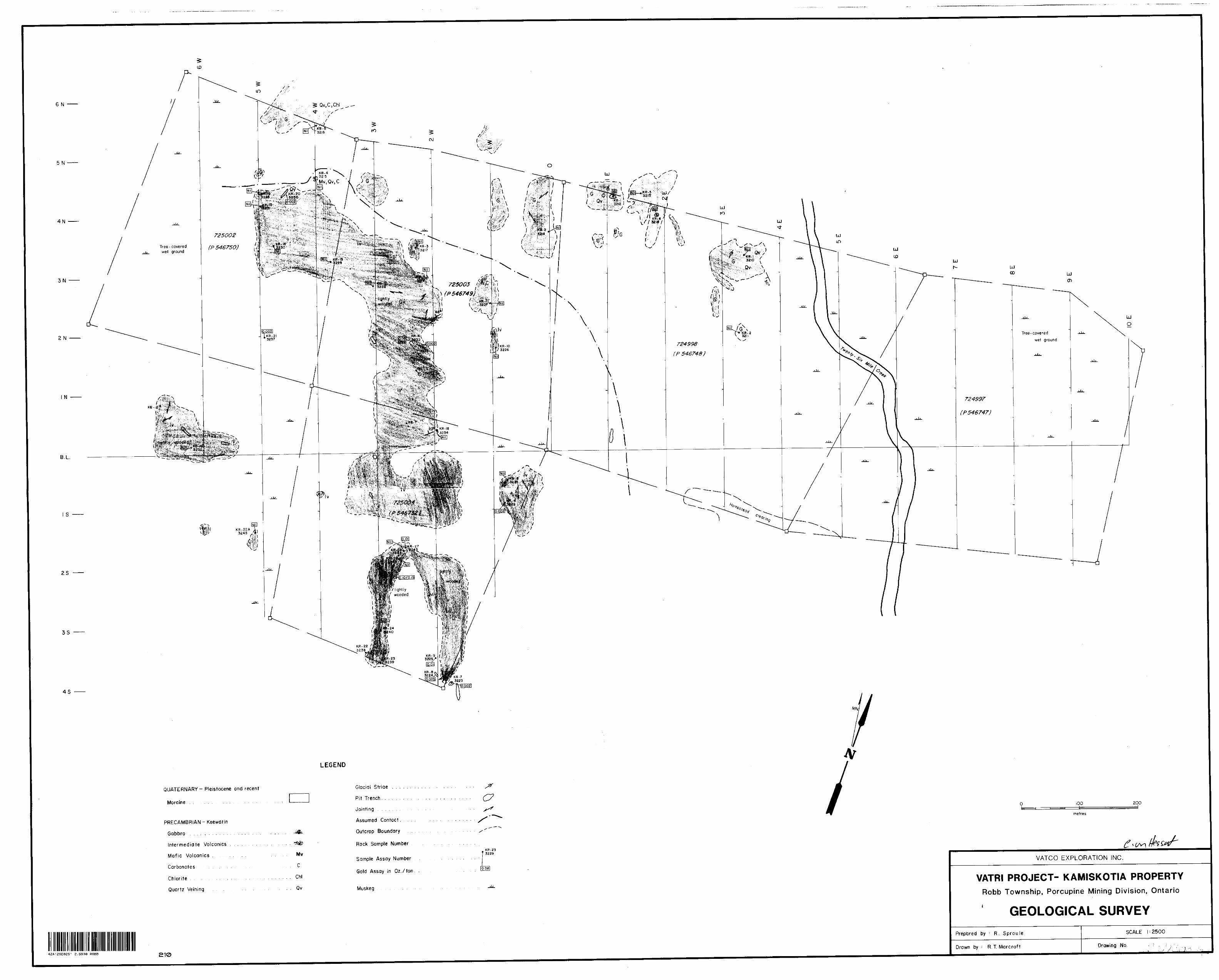
4. LINE CUTTING
A gri'd was cut over the property for control of the geological survey as well as any subsequent surveys which might be undertaken. The grid is laid out with a base line oriented at N70 0 E and with picketted grid lines crossing perpendicular to the base line every 100 meters. The station pickets on the cross lines are located at 25 meter spacings.
5. GEOLOGICIAL SURVEY
The survey was carried out using a grid as control.
Outcrops were examined and sampled to provide a basis for interpretation of subsequent surveys and to characterize the gold potential of the property.
The topography in general is hummocky with areas of outcrop forming north-northeast trending ridges. These outcrop ridges vary in relief from l to 6 meters. Areas between the ridges are generally poorly drained and host a thick growth of spruce.
Overburden thickness is assumed to be relatively shallow (0-4 meters) through the central portion of the property where outcrop is common. In the western and eastern portions overburden depth is estimated at up to 25 meters thickness.
The claims are underlain by intermediate volcanics in the south- west and central part of the property, whereas gabbro underlies the remainder of the property (see Map 2). The rocks are of early Precambrian age and according to Pyke's classification, lay within the upper part of the Deloro group.
In all, 40 samples were sent in for gold analysis (see appended
- 6 -
C. VON HESSERT. CONSULTING GEOLOGIST
certificates of analysis). The best gold analysis returned is 0.15 oz/ton (Assay #3241), obtained from sample site KR-25, located at stations 2+75W, 2+00S. The sample is a grab sample taken from an old trench which follows a quartz vein. The rock is a pyritic quartz carbonate rock, part of the vein material. Other samples taken from this trench returned .01 - Nil ounces of gold per ton .
Sample 3232 {corresponding to site KR-16) carries .09 oz/ton Au. This sample of pyritic, slightly carbonaceous intermediate volcanic rock was taken from the muck of what is presumed to be the old Homestake trench, located at stations 2+25W, 2+75N. Another sample, 3233, taken from this trench yielded 0.002 oz of gold per ton. It is interesting to note that two diamond drill sites are located nearby and were apparently aimed at the downdip extension of the Homestake trench quartz veins. Unfortunately no record of this work is filed in the assessment office.
Sample 3225 (corresponding to site KR-9) carries .01 oz/ton Au. This sample is composed of slightly pyritic quartz vein material which is cut by calcite veinlets and was taken from an old blastedpit at 2W, 3+50S.
Sample 3224 (corresponding to site KR-8) which carries 0.005 oz/ton Au, was collected from an outcrop of intermediate volcanics at stations 2+00W, 3+75S. Sample 3223 is fresh and unpyritized.
During the course of mapping a single highly carbonated sample of probable diorite was collected from loose trench material. The author was unable to subsequently relocate additional samples of this rock. Its occurrence is significant because this type of alteration is characteristic of alteration haloes in the major gold producers of Timmins.
Little structural information indicating strike or dip could be
- 7 -

C. VON HESSERT. CONSULTING GEOLOGIST
obtained. Several observations indicate joint planes often strike 135 O or 30 O and occasionally host quartz veins.
6. CONCLUSIONS
Gold content of economic potential i.e. .15 oz/ton is contained within the volcanics of the property.
Even though the area has been explored for base metals in the past, the close proximity to past and present base metal producing mines should encourage a further examination for these metals.
7. RECOMMENDATIONS
1. It is recommended that a soil geochemistry program be initiated on the property with analysis for base metals and gold.
2. On the strength of the geochemical survey, further rock sampling in the form of trenching and/or stripping should be carried out.
September 23, 1983
Geologist
8
C. VON HESSERT. CONSULTING GEOLOGIST
8. REFERENCE
Berry, L.G. (1940), Robb Jamieson Area Ontario Department Mines Report, 53.
Government of Ontario, Ministry of Natural Resources, Porcupine Mining Division Office, Assessment Record - File numbers T340, T311, T328, T632, T102, T918, T1262, T1450, T1742, T1073, T202, T1658, T1801.
Ontario Department of Mines (1970) , Robb Township GeophysicalSeries; Map No. P598: Scale l inch to 1/4 mile.
Pyke, D.R. (1978), Regional Geology of the Timmins Matachewan Area, Ontario Geological Survey, Paper 82.
Thomas, G.M. (1981), Report on Exploration, Kamiskotia Property, Robb and Turnbull Townships, for Vatco ExplorationInc .
- 9 -
C VON HESSERT. CONSULTING GEOLOGIST
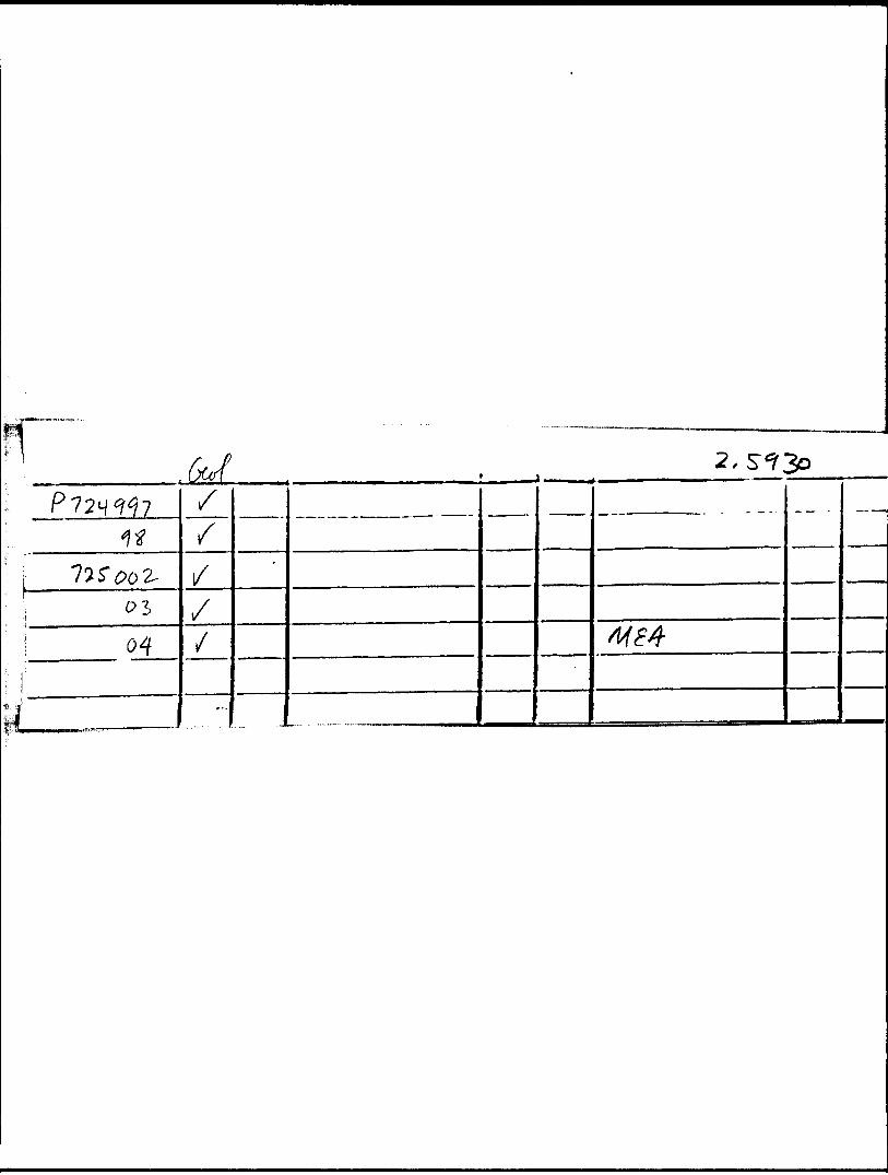
Schedule I - Assessment Due Dates
Mining Claim
P724997
P724998
P725002
P725003
P725004
R e co r d in g p at e
June 2, 1983
June 2 , 1 983
June 2, 1983
June 2 , 1 983
June 2, 1983
Assessment Credits Applied for in l983
40
40
40
40
40
Due Date
June 2, 1984
June 2 , 1 984
June 2, 1984
June 2 , 1 984
June 2, 1984
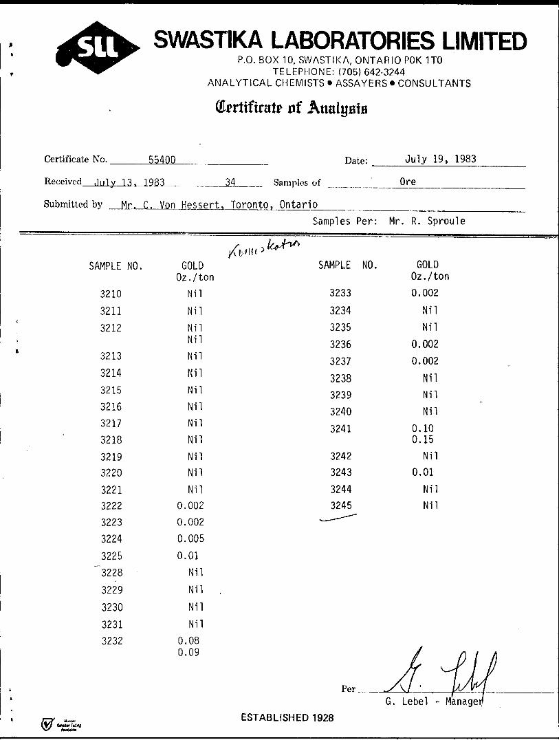
SWASTIKA LABORATORIES LIMITEDP.O. BOX 10, SWASTIKA, ONTARIO POK 1TO
TELEPHONE: (705)642-3244 ANALYTICAL CHEMISTS * ASSAYERS * CONSULTANTS
nf Analysts
Certificate No. 55400 Date: July 19, 1983
Received July 13. 1983
Submitted bv Mr. C. Von
SAMPLE NO.
3210
3211
3212
3213
3214
3215
3216
3217
3218
32193220
32213222
3223
3224
3225
"3228
3229
3230
32313232
34
Hessert, Toronto
XVn* ) 'GOLD
Oz./tonNil
NilNilNilNil
NilNil
NilNil
NilNilNil
Nil0.002
0.002
0.005
0.01
Nil
Nil .
Nil
Nil
0.080.09
Samples of
, OntarioSamples Per:
*s^h*
SAMPLE NO.
3233
323432353236
3237
32383239
3240
3241
32423243
32443245
^-^^
Ore
Mr. R. Sproule
GOLDOz./ton0.002
NilNil
0.0020.002
NilNil
Nil
0.100.15
Nil0.01
NilNil
J r\ i A
G. Lebel - ManageESTABLISHED 1928
CW**M Total

RICHARD W SPROULE Y/5 L-fcfce Street, Grimsby
Ontario. L3M 1Z9 (416) 945 1099
GEOLOGIST, MINERAL EXPLORATION with experience in all
aspects of exploration for gold, base metals and uranium
in eastern and western Canada.
EMPLOYMENT HISTORY:
1983 - present Contract Geologist Ontario
Primarily employed by C. von Hessert ft Associates
Ltd. , : ~ r : , n ; contractor.
Rorponrnble for comprehensive, cost effective
gold exploration programs for various clients.
Carried out geological, geophysical and geochemical
surveys, os well as claim staking, trenching and
diamond drill supervision.
Following up field work, reports were prepared
for presentation to the client's share holders
and government offices.
1980 - 1983 Asnmera Inc. Saskatoon As part of an exploration team explored a Million acre property, with an average annual budget of S5 million, helped to prove ore reserves of the Dawn Lake Uranium Project. This included planning arid interpreting geophysical surveys, selecting drill targets, logging core, writing reports and budget proposals.
As a project geologist, supervised a base metal exploration program on a 300,000 acre property
j^ri^rrj ... 2
JAN 3 O 1984
- 2 -
EfMPLOYMENT HISTORY (continued)
Obtained contracts, hired and supervised eight
staff, prepared assessment reports and budgets
and kept partners informed of progress and results.
When necessary carried out property evaluations
on uranium, precious metal and base metal
properties in Ontario, Manitoba, Saskatchewan
and Alberta.
1979 Oominco Ltd. Toronto
In charge of a field crew on a regional search
for gold, tin, tungsten nnd molybdenum in Nova
Scotia.
Assisted in both regional and detailed uranium
exploration programs, by performing geophysical
surveys, detailed and regional mapping, geochemical
sampling! diamond drill supervision and writing field reports.
1978 Chevron Standard Ltd. Minerals Vancouver
Responsible for the completion of the Nova Scotia
base metal exploration program. Supervision of
diamond drilling and geochem surveys was required,
other duties included detailed mapping, core logging
and assessment report writing.
I'lc-y - September 1977 Chevron std. Ltd. Minerals
1'art of a field crew on -i regional search for
base metals. Tasks performed included regional
mapping, drafting and genera] prospecting.
...3
- 3 -
HISTORY (continued)
May - December 1976 Esso Minerals (consultant
r.E.Schenk) Halifax
Assisted in the research to determine the
depositional origin of the Gay's River lead
zinc ore body.
1970 - 1975 Electronic organ repair
Inventory control at a car dealership
Antique furniture repair
Assembly line labourer
EDUCATION:
BSc. Geology (4Yr) Dalhousie University 1979
2 years at Mohawk College enrolled in a control
systems course 1968 - 1970
Professional Affiliations:
Kember, Canadian Institute of Mining and Metallurgy
Presently waiting acceptance as Fellow of the G. A. C.
PERSONAL:
Born; 1949 harried, two children
Excellent health Canadian Citizen
Ministry offSatuiAtResources
Ontario
Report oW/Vork(Geophysical, Geological, Geochemical andjE xoenditures)
42A12SE8251 2.5930 ROBB 900The
Type of S
m. __ Claim Holder is)'
Address
Township or Area
JProspectorV^fcence No.
"*V
)rvj/rcen
Survey Company Date of Survey (from 81 to)
---..-—Name and Address of Author (of Geo-Technical report)
Total Miles of line Cut
Credits Requested per Each Claim in Columns at right Mining Claims Traversed (List in numerical seouence)Special Provisions , G eophysica| ; Days per
CI a t mFor first survey: .-, - Electromagnet c
Enter 40 days. (Thisincludes line cutting) . Magnetometer
i- , , ,. . , - Radiometric For each additional survey:usina the same arid:
- OtherEnter 20 davs (for each) "^ r--^
Geological ) 1 * ^
GeocheiYiica!
'/an Days ' D^sys pe^ Geophysical CI- 1 m
Complete reverse side , . - Electromagnet c
ana enter totals) here
- Magnetometer
- Radiometric
- Otner
i Geological
Geochemical -
*\irho r ne Crecms i - Days p e* Claim
Note: SotCia! provisions i Electromagnetic Cfrd.ts rio not 2pp!y i *. —- ~— ——lo Airbo-ne Surveys- Magnetometer
i m _ ^ _ _
i Radiometric
Expenditures {exchJCi^s power siripuin^lType Ot Wo r k P^rro^nicd
^-e-iorn-iea on Qairrus)
CdfcutdTion of nxpenri'Ture D.^ys Credits
Total Expenditures Days O'cd'ts
S ] : 15 -
instructions Total Das'S Credits may be apportioned at the claim holder's choice. Enter number of days credits per claim selected in columns et riant.
D.3te / j R eco^sd f-iolaer or AgentLSionaturel
ti
Mining ClaimPrefix i Number
P J 21331 'jy^/tyQfi?Z5 oo 2.715 003
r^vu. y co^/U- .^-^^
..-- . rir^u.'i:^J.;::.i:
^^-
A.Mr ~
Expend. Davs Cr.
——————
— t A!
••— ~~
193?"i;-:, '-i-'
^
R r -— - oRccsi'j:
p. r
Ci*- '1
Mining ClaimPrefix i Number
!
! f
"|
j
j" "1
. — ...-—
!CF-m-"~
——
OV 3 'i 1983
-' LAlirx- "'-^ , i jT——
i
**~'"*"B Di:rD-'
. f^J'v j ————1 fiUl-ft-fhinK^T-"iT' 'fTfflTclaims covered by th toport of work.
For Office Use OnlyTotal Days Cr.^Date Rcco'tied
:l" ^ffiffi.J^JcflAw C
-'•"""^ ^
S^^f, x^ESS^c
Csrti'f'cation Ver:iyiitq Rtrjofl of Vf'ork tyftJ [ ^hereny certify thps 1 h.:)v? a persons and intimate knowledge of the facts set! forth in the Report of Work annexes
or witnessed same during and/oi after its completion and the anrexed report is true.
Nc-.mo an:j Postal A:--*reis of Pe'jOn Cert fymg
^ ^f X x z - irs?nfSociei'(:^ ^i^ff 2bf
[Date Certified*\
—— -——
ng s
r-?
T
———
Expend. Days Cr.
— — —-
. —————
5
W-— "
•u:reto, having performed the work
t&.^r**I^IM^IOV, ignatu
••'ss--***S'4*'
e)'t- F -
^ g
Ministry of Natural
Ontario
Report of Work(Geophysical, Geological, Geochemical and Expenditures)
O*- * O
The Mining Act
Instructions: — Please type or print.— If number of mining claims traversed
exceeds space on this form, attach a l ist.Note: — Only days credits calculated in the
"Expenditures" section may be entered^jn-4he—"Expendr—Qays Cr." columns.
^~~^~^- Do not use shaded areasType of Survey(s)
Claim Holder(s)1\) 6.
Address
i rSurvey Company
C-Date of Survey (from a to)LI , 6 f* \ 1 3Day l Mo. | Yr. j fcay |
Name and Address of Author (of Qeo-Technical report)
C-Credits Requested per Each Claim in Columns at rightSpecial Provisions
For fint lurvey:Enter 40 days. (This includes line cutting)
For each additional survey: using the same grid:
Enter 20 days (for each)
Man Days
Complete reverse side and enter total (s) here
Airborne Credits
Note: Special provisions credits do not apply to Airborne Surveys.
Geophysical
- Electromagnetic
- Magnetometer
- Radiometric
- Other
Geological
Geochemical
Geophysical
- Electromagnetic
- Magnetometer
- Radiometric
- Other
Geological
Geochemical
Electromagnetic
Magnetometer
Radiometric
Days per Claim
Z fif^~
Days per Claim
Days per Claim
Expenditures (excludes power strjppirtgTType of Work Performed
InstructionsTotal Days Credits may be apportioned at the claim holder's choice. Enter number of days credits per claim selected In columns at right.
Jf/83Cerlffication Verifying Report ofWork
ent (Signature)
Mining Claims Traversed (List in numerical sequence)Mining Claim
Prefix
P
Number
7M9 f ?7s.i?*)ZVjL&ott-
7/SaaJ
725^
R L-
j
Receipi
Expend. Days Cr.
'
"M : "\ ! ^ \) (
\IIR n:AUD A ;
!(0.
IN
i
f t) l.
Mining ClaimPrefix
Rf(' ' , - ". : -'i
"q ;u
3 t: 0
83
Number
:ervpQBm U
•J ' K'.
•VOS SFrr,J *tvuoi\
Expend. Days Cr.
Total number of mining 1 ^ claims covered by this l l-\ reoort of work. 'li a
l hereby certify that l have a personal and intimate knowledge of the facts set forth in the Report of Work annexed hereto, having performed the work or witnessed same during and/or after its completion and the annexed report is true.
Name and Postal Address of Person Certifying^/e, t/ou
Date Certified9AjJ-fsi /)jj*f
d by ture)

CHRISTIAN VON HESSERT CONSULTING GEOLOjaSX.
SUITE 2OO - 49 WELLINGTON TORONTO. ONT. M5E|
January 27, 1984
J. R. Morton Whitny Block, Room 6643 Queen's Park Toronto, Qatario M7A 1W3
Dear Mr. Morton:
Re: Your File 2.5930, Geological Survey submitted on Mining Claims P724997 et al in the Township of Robb
Enclosed as you requested, are the coloured naps of the above mentioned Geological survey and a copy of R. M. Sproule's resume.
•"RE©*EivBD1lSftd Management Bnnch
CIRCULATE D COMMENTS H.11M fi BY "^
JAN 301984E. F. ANDERSON
J. R. MORTON
J. C. SMITH
W. L. OOOQ
J. M. &MALL
mvru;\'N TO R. e64S
(416) 863-6796
Yours truly,
R. M. SprouleGeologistC. von Hessert S Associates Ltd.
cc: Bruno Vatri
Enclosures
ELEHWI301984
j LANDS S:CTION
Ontario
Geotechnical Natural o ,.nnrt Resources R ftPOrt
Approval
FM*
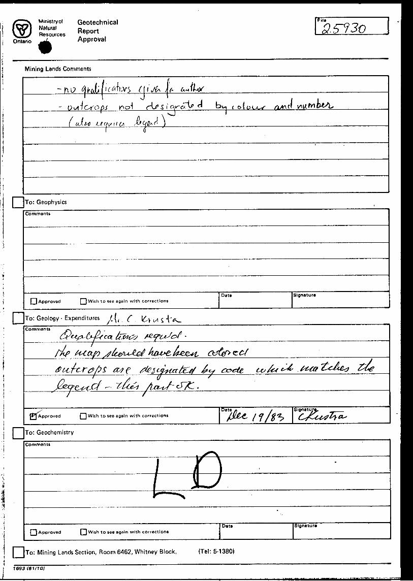
3.5730
Mining Lands Comments
f l 'tt- J
-d r-i Or'opj S n bu ( of ou.^
i l P., K J(\l uJ^t Jit a i/ ii f/, S*JQQK(\ i J———————pii/———^———^
l DTo: Geophysics
Comments
LJ Approved Wish to see a gain with correctionsDate Signature
To: Geology - Expenditures ^ t (
Comments
JPj Approved Wish to see again with corrections JSiflnatu
•i DTo: Geochemistry
Comments
PI Approved | 1 Wish to see again with correctionsDate Slgnatur*
To: Mining Lands Section, Room 6462, Whitney Block. (Tel: 5-1380)
T693
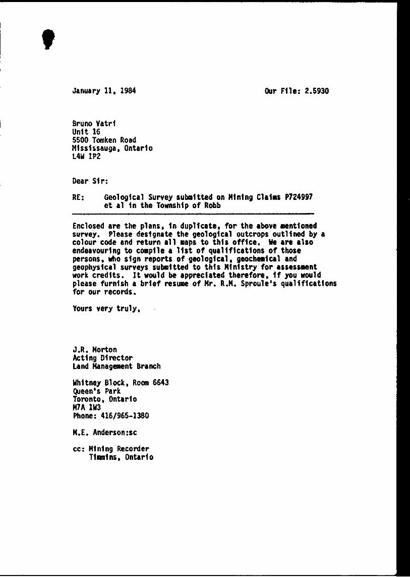
tJanuary 11, 1984 Our File: 2.5930
Bruno VatrlUnit 165500 Tomken RoadMlsslssauga, OntarioLAM 1P2
Dear Sir:
RE: Geological Survey submitted on Mining CI a lw P724997 et al In the Township of Robb
Enclosed are the plans, In duplicate, for the above Mentioned survey. Please designate the geological outcrops outlined by a colour code and return all naps to this office. He are also endeavouring to compile a list of qualifications of those persons, who sign reports of geological, geochemical and geophysical surveys submitted to this Ministry for assessment work credits. It would be appreciated therefore, If you would please furnish a brief resume of Mr. R.M. Sproule's qualifications for our records.
Yours very truly,
J.R. MortonActing DirectorLand Management Branch
Whitney Block, Room 6643Queen's ParkToronto, OntarioM7A 1W3Phone: 416/965-1380
M.E. Anderson:se
cc: Mining Recorder Timmins, Ontario

1983 10 28
218
2.5930
Mining RecorderMinistry of Natural Resources60 Wilson AvenueTimmins, OntarioP4N 2S7
Dear Sir:
We have received reports and maps for a Geological survey submitted under Special Provisions (credit for Performance and Coverage) on mining claims P 724997 et al 1n the Township of Robb.
This material will be examined and assessed and a statement of assessment work credits will be Issued.
Yours very truly,
E.F. AndersonDirectorLand Management Branch
Whitney Block, Room 6643 Queen's Park Toronto, Ontario M7A 1W3 Phone:(416)965-1380
A. Barr:me
cc: Bruno Vatrl Unit 165500 Tomken Road Mlsslssauga, Ontario L4W 1P2
cc: Richard Sproulec/o C. von Hessert and AssociatesSuite 20049 Wellington Street EastToronto, OntarioM5E 1C9

o.-veV
r Wsjii i jp3; F^T- 7r.
•r sfl
! t
\ O
3
! O
-T
-i^T
'
\ ' ::
~ .
- '! i
w
* ,
[o, s f/7 /") !^J2- 10- " -^
"^
' i i""---1' /-''a ^
. ::
Jr .../'~
o^ xrp^r ^pin---I
^
l '
- -i
r.^— I*
*V
fi
3J *'
•s \ - .a., (~^
i ^ --V
*. - W
CvV
:_W
A v
o
-o
-Sk
~0 -vj
K)
-C
G o
H
C CD c: OJ
COTE
TP
M.
271
o < rn H
ro ro
(O
OJ
JAM
IESO
N
TP
M.2
88
5 z (SI
en
^f"
"
^^^
5 -*
S Q
- Z
>O
r-
CD
?
O
;
rnz
*"o
O1
c 73 ri m
o z
"O r z o OJ
O
CD
O c; "U m H
O J-TT, o C
"5
CO
O
H-*
3
-O
"'
ST ~
- 2.
o
z --**' tJ o.
W
J* ^g(
I'll
••- y
*
OL !i|
r0
S.to
O
b 51
—
3
(O
(Q
2 5
- Q
. If n f'
Q V
.~
W
O
~*
O. (
Q O
O O 3
•O
z o H m Oi
mr m CD
m z D
O)
D > r m z o I II ^ o o x z en
-7 "o oS O
25 m^
O Z
D
o mO H O
O CD
CD
H I m
00
Vi "D
6 N
5N
4N
2N
IN
B.L.
l S
2S
3S
4S
^i^^lp^l®
724998
(P 546748)
724997
(P546747)
'^^^K^iif^il^- wS?l*j^Jv v'-1- S'-'-^ JT?y,.v -**"t, : ;..;
i--.- '--.ilKW*lSipB?ss4c?^i
^'W^u.'^w--' 1 '',)"S ; '-"'^j^*l r*jfiA.n:^li.h^iJiU.,i'i*lrli^-4VJi" ;'.^^"1*" **
ir i''' m'-
. . . s-.sj^)i K.,T \i ^ ^i?**?!
C- : :-w^; i4|# S'^^PPi-••^ '•.".-., .hF1 ;:^'-' •--^ i ' *^ ^';i^.i;-A-,';"^',\ ^
LEGEND
QUATERNARY- Pleistocene and recent
Moraine . . . .
PRECAMBRIAN - Keewatin
Gabbro . . . . . . . . . . .
Ihtermediale Volcanics
Mafic Volcanics . .
Carbonates
Chlorite . . . . .
Quartz Veining
Mv
C
Chl
Qv
Glacial Striae . . . . . ,
Pit Trench. . . . . . . . .
Jointing . . . . . . .
Assumed Contact.
Outcrop Boundary
Rock Sample Number
Sample Assay Number
Gold Assay in Oz./ton
Muskeg . . . .
C?100 200
melres
KR-23 3229
42A12SE0251 2.5930 ROBB 210
VATCO EXPLORATION INC.
VATRI PROJECT- KAMISKOTIA PROPERTY
Robb Township, Porcupine Mining Division, Ontario
GEOLOGICAL SURVEY
Prepared by : R, Sproule
Drawn by : R.T. Marcroft
SCALE l:2500
Drawing No.