geology and fossils of north central texas (fort worth to
TRANSCRIPT
Stephen F. Austin State University Stephen F. Austin State University
SFA ScholarWorks SFA ScholarWorks
Faculty Publications Department of Geology
2-16-2021
Geology and Fossils of North Central Texas (Fort Worth to Mineral Geology and Fossils of North Central Texas (Fort Worth to Mineral
Wells): Texas Academy of Science February 28 2021 Wells): Texas Academy of Science February 28 2021
R. LaRell Nielson
Follow this and additional works at: https://scholarworks.sfasu.edu/geology
Part of the Geology Commons
Tell us how this article helped you.
Geology and Fossils of North Central Texas (Fort Worth to Mineral Wells) Page 1
Geology and Fossils of North Central, Texas (Fort Worth to Mineral Wells)
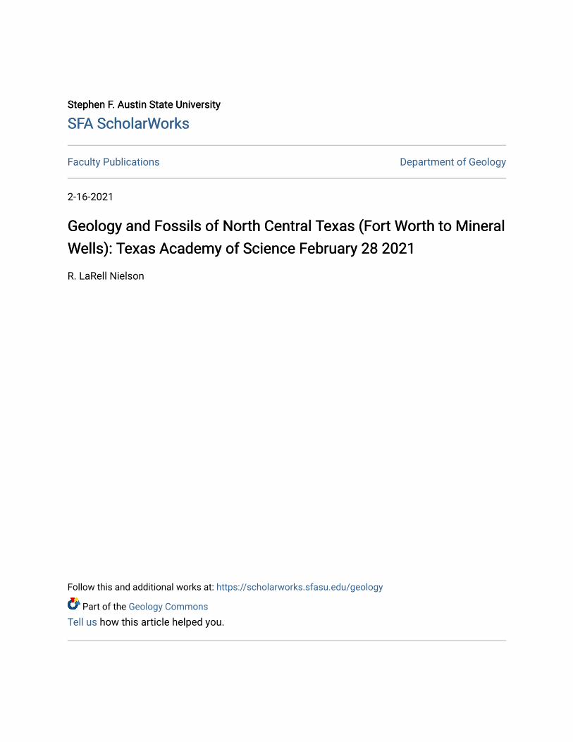
Collecting location at the Mineral Wells Fossil Park, Mineral Wells, Texas (2021)
Texas Academy of Science February 28, 2021
Trip Leader:
Dr. R. LaRell Nielson
Department of Geology
Geology and Fossils of North Central Texas (Fort Worth to Mineral Wells) Page 2
Stephen F. Austin State University Nacogdoches, Texas
Video Field Trip Link: https://www.youtube.com/watch?v=EJKSgqtLvw0
I would like to thank Dr. Mike T. Read and Dr. Jenny Rashall for helping in the production of this field guide. This guidebook would not have been possible without their photos, suggestions and editing of this guidebook. Dr. Rashall photographed the fossils that are illustrated in association with the Goodland Limestone. I would also like to thank Sylvia Nielson my wife for here help and support in putting the guidebook together.
Geology and Fossils of North Central Texas (Fort Worth to Mineral Wells) Page 3
Geology and Fossils of North Central, Texas (Fort Worth to Mineral Wells)
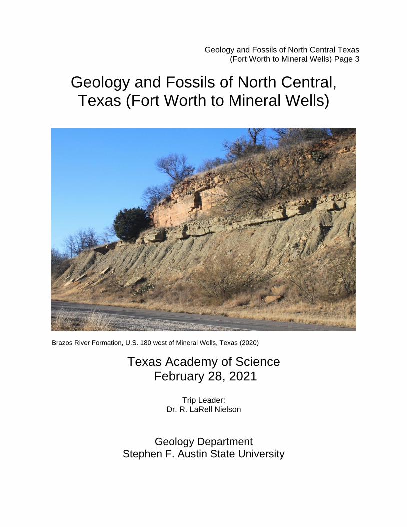
Brazos River Formation, U.S. 180 west of Mineral Wells, Texas (2020)
Texas Academy of Science February 28, 2021
Trip Leader:
Dr. R. LaRell Nielson
Geology Department
Stephen F. Austin State University
Geology and Fossils of North Central Texas (Fort Worth to Mineral Wells) Page 4
Nacogdoches, Texas
Table of Contents Introduction…… .…………………………………………………………………..8 1. Stop 1 ………………….……………………………………………………….17 2. Stop 2………………………….………………………………………………..22 3. Stop 3………………………………….………………………………………..26 4. Stop 4……………………………….………………………..…………………35 5. Stop 5…………………………………………………………………………...40 6. Stop 6……………………………………………………………………………46
Geology and Fossils of North Central Texas (Fort Worth to Mineral Wells) Page 5
List of Figures Figure 1. Index map showing stops 1 and 2 near Fort Worth, Texas… ………………6 Figure 2. Index map showing the locations of stops 2 through 6………………………7 Figure 3. Tectonic map showing the major basins and fold belts in Texas…………...8 Figure 4. Map of the major faults and structural features of central Texas...…………9 Figure 5. Geologic map of the region west of the Dallas-Fort Worth area…..………10 Figure 6. Generalized geologic map of the Dallas Fort Worth Texas area………….11 Figure 7. Generalized stratigraphic column for the Cretaceous strata…………..…..12 Figure 8. Generalized facies map for the Fredericksburg division, Cretaceous..…..13 Figure 9. Generalized facies map for the Trinity division, Cretaceous………..……..14 Figure 10. Stratigraphic cross section for the eastern Fort Worth Basin…………….15 Figure 11. Geologic map of the Lake Benbrook area……….....……………………...17 Figure 12. Outcrops of the Goodland Limestone……………..…….………………….18 Figure 13. Common mollusk fossils found in the Goodland Limestone………..........19 Figure 14. Common mollusk fossils found in the Goodland Limestone……….……..20 Figure 15. Fossil beds in the lower part of the Walnut Formation, Mosque Point......22 Figure 16. Fossil beds in the lower part of the Walnut Formation, Mosque Point..…22 Figure 17. Stratigraphic section Mosque Point showing the Paluxy Sandstone…….23 Figure 18. Geologic map of Mosque Point…..…….…..………………………………..24 Figure 19. Exposures of the Paluxy Sandstone along U.S. Highway 180……….…..25 Figure 20. Geologic Map of south-central Parker County - Paluxy Sandstone..…....26 Figure 21. Stratigraphic relationship between the Paluxy and Glen Rose…….….….27 Figure 22. Relationship between the Paluxy Sandstone and surrounding units…….28 Figure 23. Geologic map west of Weatherford, Texas……….………………………...29 Figure 24. Paleogeographic map: Permian Basin region……………………..……….30 Figure 25. Geologic map of the eastern Fort Worth Basin………………………….….31 Figure 26. Stratigraphic column Pennsylvanian formations, Fort Worth Basin…...…32 Figure 27. Pennsylvanian sea level curve showing the Pennsylvanian cycles……...33 Figure 28. Stratigraphic columns, Pennsylvanian strata eastern Fort Worth Basin…35 Figure 29. Geologic map of the Strawn Group, Mineral Wells, Texas………………..36 Figure 30. Exposure of the Mingus Shale at Stop 4 along U.S. Highway 180……....37 Figure 31. Simplified depositional cross-section of a prograding delta complex…….38 Figure 32. U.S. Highway 180 road cut exposing the Mingus Shale……….……….....40 Figure 33. Geologic map show stops 4, 5 and 6 in the Mineral Wells area...………..41 Figure 34. Depositional model for the Pennsylvanian units Fort Worth Basin area…42 Figure 35. Generalized depositional model for delta progradation……………………43 Figure 36. Depositional model for distributary channel, Brazos River Formation…...44 Figure 37. Fossilized remains of the genus Stigmaria, the taxononomic…….………45 Figure 38. Image of Mineral Wells Fossil Park, Mineral Wells, Texas…………….….47 Figure 39. Geologic Map of the Mineral Wells Fossil Park area…….………..……….48 Figure 40. Stratigraphic column, for Mineral Wells Fossil Park, Texas……..…………49 Figure 41. Depositional models for the Fort Worth Basin Late Pennsylvanian....……50
Geology and Fossils of North Central Texas (Fort Worth to Mineral Wells) Page 6
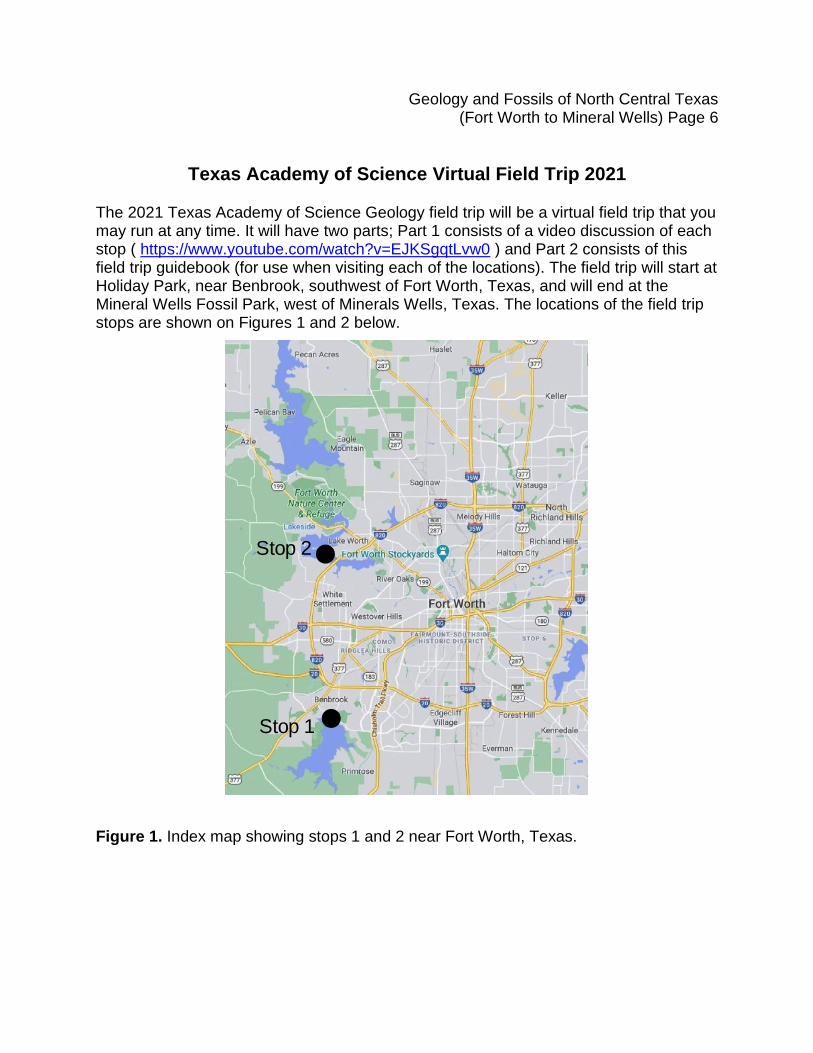
Texas Academy of Science Virtual Field Trip 2021 The 2021 Texas Academy of Science Geology field trip will be a virtual field trip that you may run at any time. It will have two parts; Part 1 consists of a video discussion of each stop ( https://www.youtube.com/watch?v=EJKSgqtLvw0 ) and Part 2 consists of this field trip guidebook (for use when visiting each of the locations). The field trip will start at Holiday Park, near Benbrook, southwest of Fort Worth, Texas, and will end at the Mineral Wells Fossil Park, west of Minerals Wells, Texas. The locations of the field trip stops are shown on Figures 1 and 2 below.
Figure 1. Index map showing stops 1 and 2 near Fort Worth, Texas.
Stop 1
Stop 2
Geology and Fossils of North Central Texas (Fort Worth to Mineral Wells) Page 7
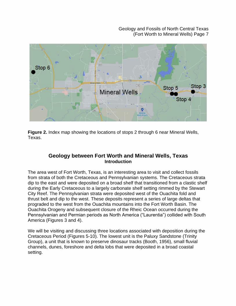
Figure 2. Index map showing the locations of stops 2 through 6 near Mineral Wells, Texas.
Geology between Fort Worth and Mineral Wells, Texas
Introduction The area west of Fort Worth, Texas, is an interesting area to visit and collect fossils from strata of both the Cretaceous and Pennsylvanian systems. The Cretaceous strata dip to the east and were deposited on a broad shelf that transitioned from a clastic shelf during the Early Cretaceous to a largely carbonate shelf setting rimmed by the Stewart City Reef. The Pennsylvanian strata were deposited west of the Ouachita fold and thrust belt and dip to the west. These deposits represent a series of large deltas that prograded to the west from the Ouachita mountains into the Fort Worth Basin. The Ouachita Orogeny and subsequent closure of the Rheic Ocean occurred during the Pennsylvanian and Permian periods as North America (“Laurentia”) collided with South America (Figures 3 and 4). We will be visiting and discussing three locations associated with deposition during the Cretaceous Period (Figures 5-10). The lowest unit is the Paluxy Sandstone (Trinity Group), a unit that is known to preserve dinosaur tracks (Booth, 1956), small fluvial channels, dunes, foreshore and delta lobs that were deposited in a broad coastal setting.
Geology and Fossils of North Central Texas (Fort Worth to Mineral Wells) Page 8
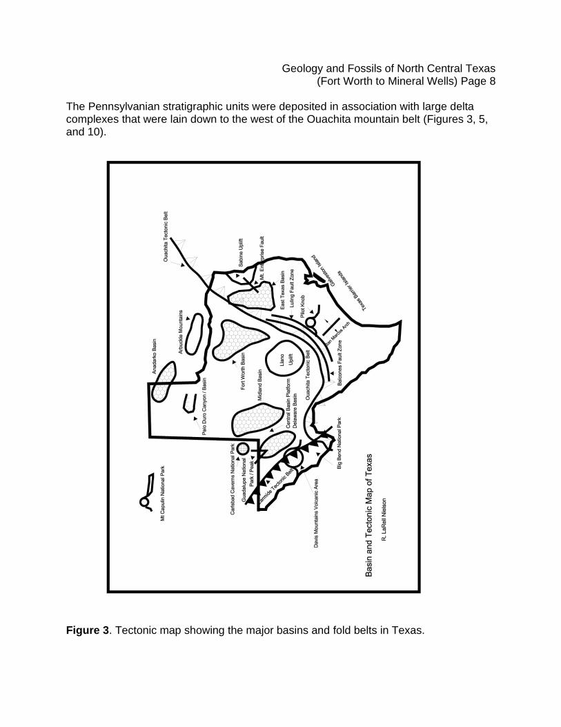
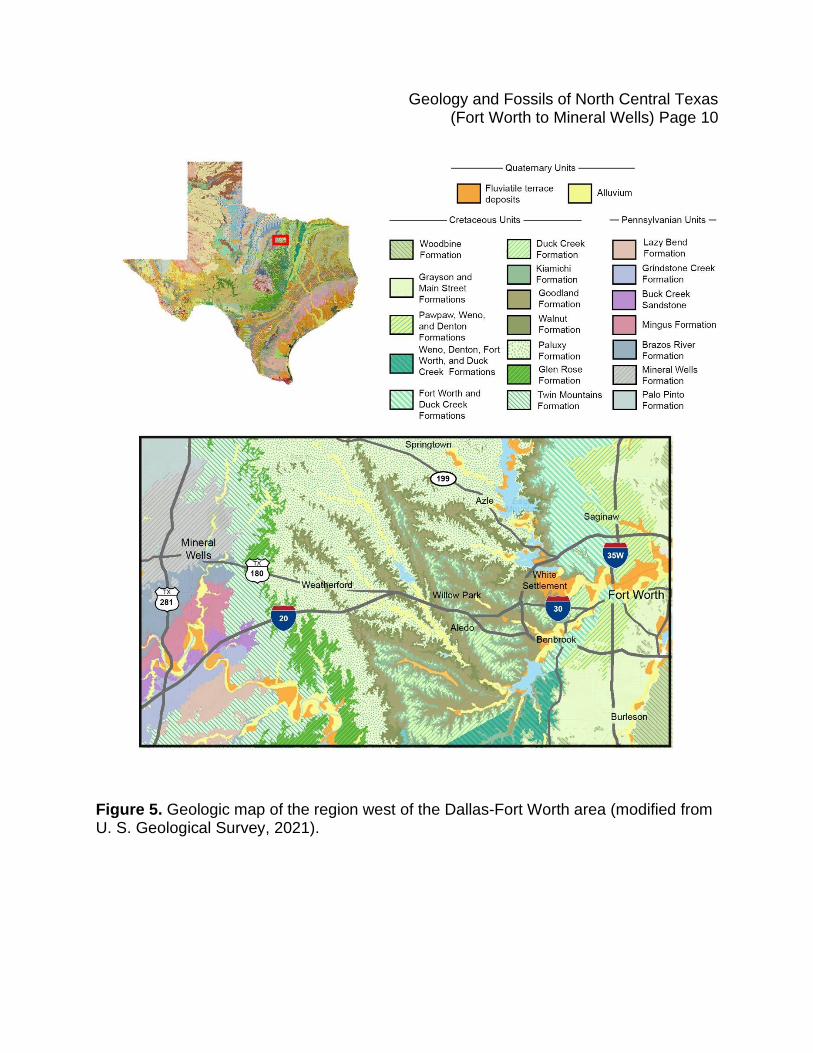
The Pennsylvanian stratigraphic units were deposited in association with large delta complexes that were lain down to the west of the Ouachita mountain belt (Figures 3, 5, and 10).
Figure 3. Tectonic map showing the major basins and fold belts in Texas.
Geology and Fossils of North Central Texas (Fort Worth to Mineral Wells) Page 9
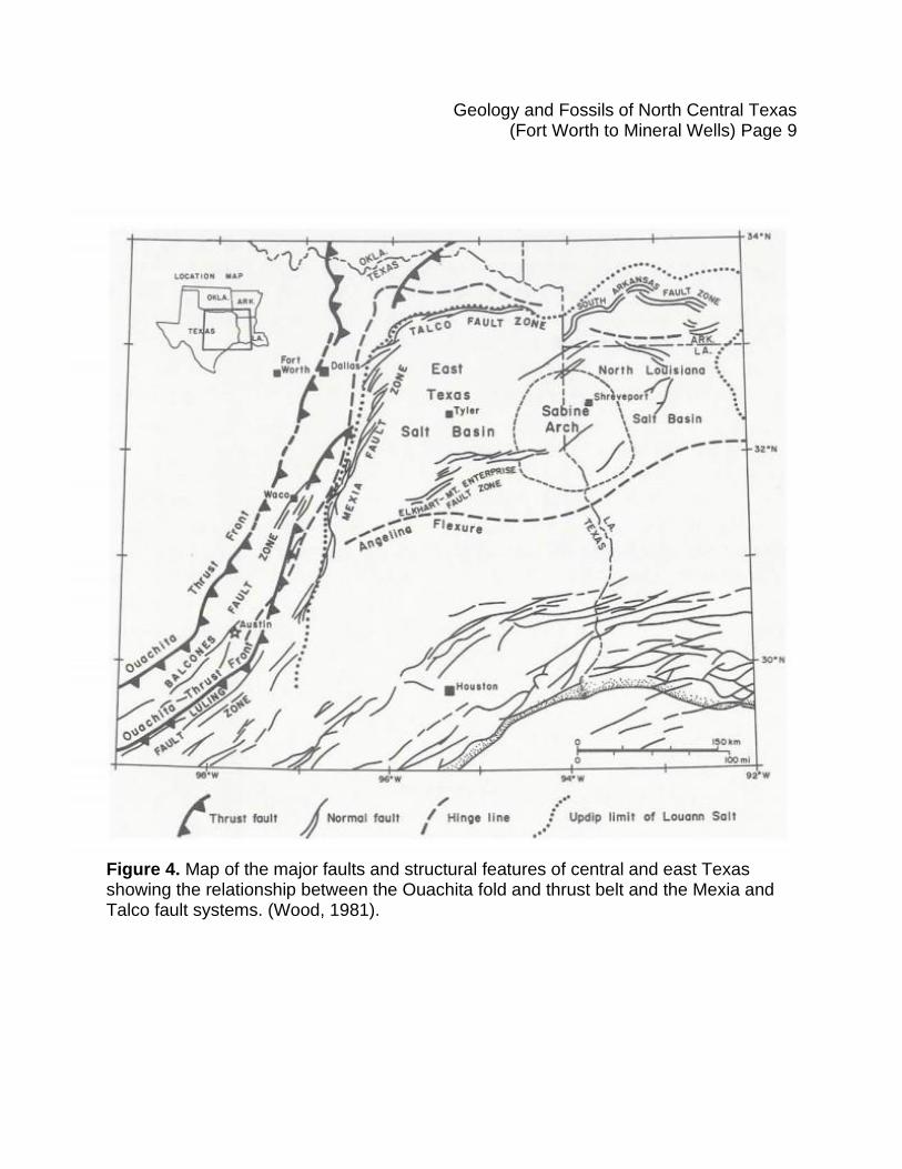
Figure 4. Map of the major faults and structural features of central and east Texas showing the relationship between the Ouachita fold and thrust belt and the Mexia and Talco fault systems. (Wood, 1981).
Geology and Fossils of North Central Texas (Fort Worth to Mineral Wells) Page 10
Figure 5. Geologic map of the region west of the Dallas-Fort Worth area (modified from U. S. Geological Survey, 2021).
Geology and Fossils of North Central Texas (Fort Worth to Mineral Wells) Page 11
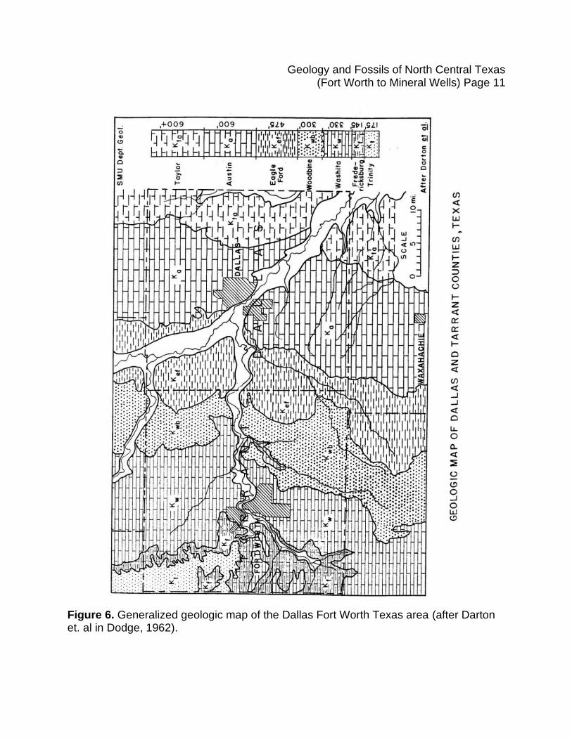
Figure 6. Generalized geologic map of the Dallas Fort Worth Texas area (after Darton et. al in Dodge, 1962).
Geology and Fossils of North Central Texas (Fort Worth to Mineral Wells) Page 12
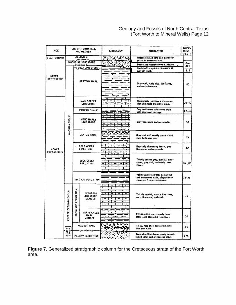
Figure 7. Generalized stratigraphic column for the Cretaceous strata of the Fort Worth area.
Geology and Fossils of North Central Texas (Fort Worth to Mineral Wells) Page 13
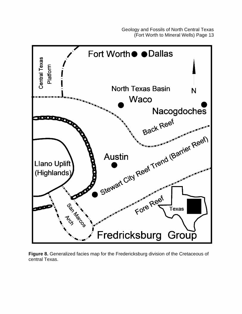
Figure 8. Generalized facies map for the Fredericksburg division of the Cretaceous of central Texas.

Geology and Fossils of North Central Texas (Fort Worth to Mineral Wells) Page 14
Figure 9. Generalized facies map for the Trinity division of the Cretaceous of central Texas.
DallasFort Worth
Waco
Austin
Nacogdoches
Fore Reef
Stewart City Reef T
rend (Barrie
r Reef)
Llano Uplift
(Highlands)
North Texas Basin
San M
arcos
Arch
Trinity Group
N(Hig
hla
nds)
Flu
vial (
Riv
er)
Coa
stal -
Barr
ier Is
lands
She
lf San
ds
Angelina - Caldwell F
lexure
Back Reef
San Antonio
Texas
Centr
al T
exas P
latform
Geology and Fossils of North Central Texas (Fort Worth to Mineral Wells) Page 15
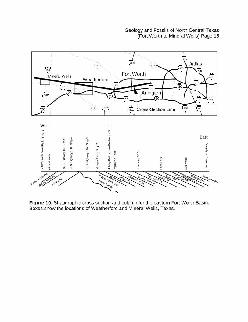
Figure 10. Stratigraphic cross section and column for the eastern Fort Worth Basin. Boxes show the locations of Weatherford and Mineral Wells, Texas.
20
2020 20
30 3030
30
35W
35W
35E
35E
17520
114199
281
281
171 377377
820
635635635
45
20
Mineral WellsWeatherford
Fort Worth
Dallas
Arlington
180
Cross-Section Line
West
East
Paluxy Sandstone
Woodbine Fm
Grayson Fm
Mainstreet Ls
Pawpaw Fm
Weno FmDenton Fm
Fort Worth Ls
Duck Creek Fm
Kiamichi Shale.
Goodland Ls
Walnut Fm
Mingus Fm
Brazo
s Rive
r Ss
Mineral W
ells F
m
Min
era
l W
ells
Min
era
l W
ells
Fossil
Park
- S
top 6
Mo
sq
ue
Po
int
- S
top
2
Insp
ira
tio
n P
oin
t
Iin
ters
tate
30
Cu
t
Co
bb
Pa
rk
La
ke
Wo
od
La
ke
Arlin
gto
n S
pill
wa
y
Ho
lida
y P
ark
-
La
ke
Be
nb
roo
k -
Sto
p 1
U.
S,
Hig
hw
ay 1
80
- S
top
3
U.
S,
Hig
hw
ay 1
80
- S
top
4
U.
S,
Hig
hw
ay 1
80
- S
top
5
(Trinity Group)
Geology and Fossils of North Central Texas (Fort Worth to Mineral Wells) Page 16
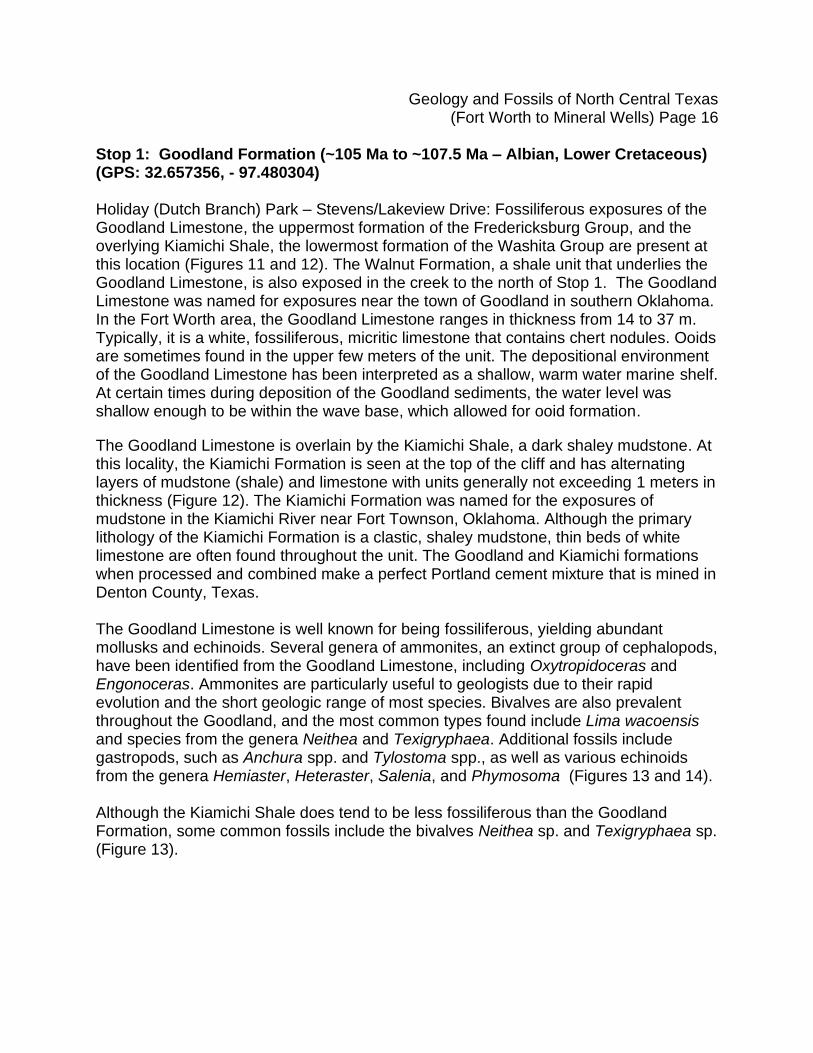
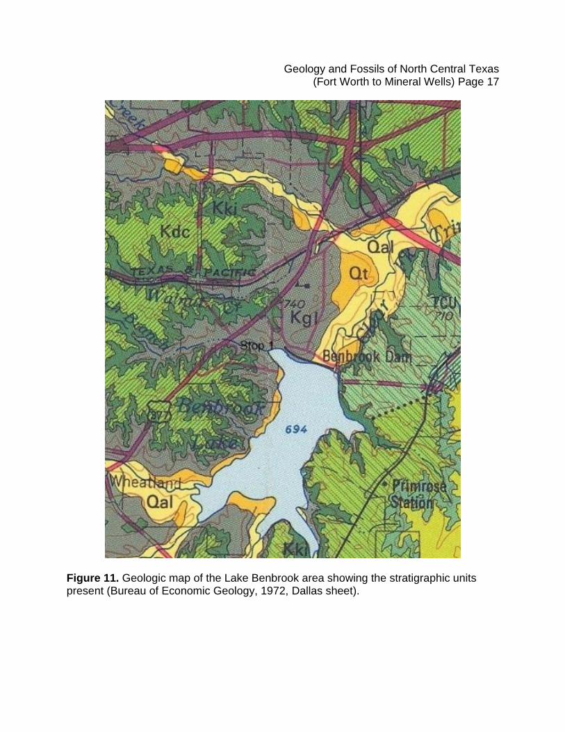
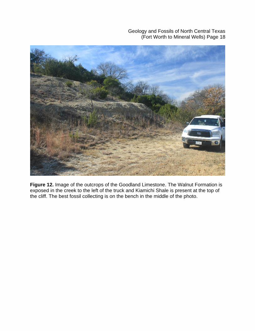
Stop 1: Goodland Formation (~105 Ma to ~107.5 Ma – Albian, Lower Cretaceous) (GPS: 32.657356, - 97.480304) Holiday (Dutch Branch) Park – Stevens/Lakeview Drive: Fossiliferous exposures of the Goodland Limestone, the uppermost formation of the Fredericksburg Group, and the overlying Kiamichi Shale, the lowermost formation of the Washita Group are present at this location (Figures 11 and 12). The Walnut Formation, a shale unit that underlies the Goodland Limestone, is also exposed in the creek to the north of Stop 1. The Goodland Limestone was named for exposures near the town of Goodland in southern Oklahoma. In the Fort Worth area, the Goodland Limestone ranges in thickness from 14 to 37 m. Typically, it is a white, fossiliferous, micritic limestone that contains chert nodules. Ooids are sometimes found in the upper few meters of the unit. The depositional environment of the Goodland Limestone has been interpreted as a shallow, warm water marine shelf. At certain times during deposition of the Goodland sediments, the water level was shallow enough to be within the wave base, which allowed for ooid formation.
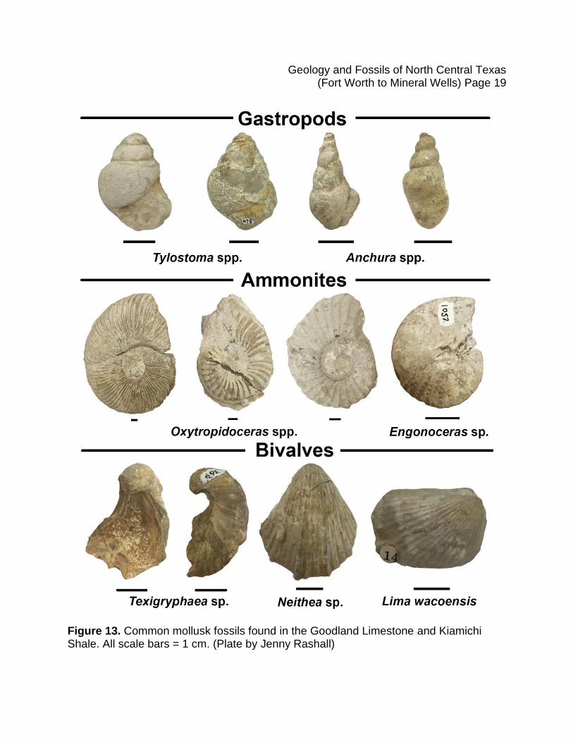
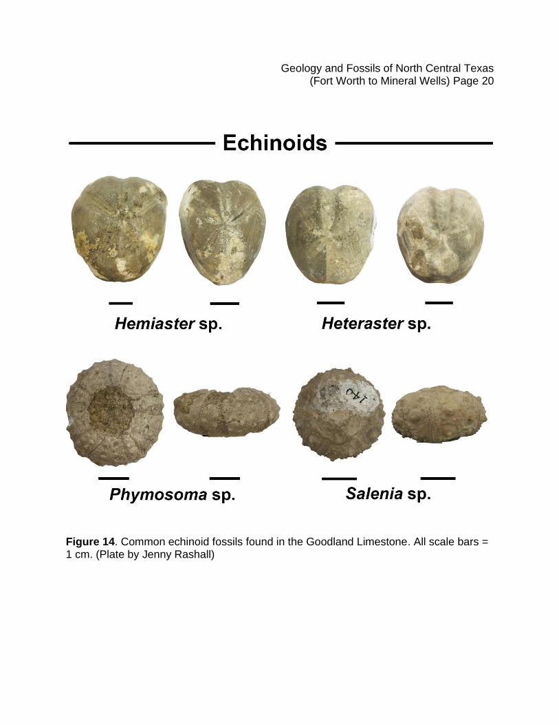
The Goodland Limestone is overlain by the Kiamichi Shale, a dark shaley mudstone. At this locality, the Kiamichi Formation is seen at the top of the cliff and has alternating layers of mudstone (shale) and limestone with units generally not exceeding 1 meters in thickness (Figure 12). The Kiamichi Formation was named for the exposures of mudstone in the Kiamichi River near Fort Townson, Oklahoma. Although the primary lithology of the Kiamichi Formation is a clastic, shaley mudstone, thin beds of white limestone are often found throughout the unit. The Goodland and Kiamichi formations when processed and combined make a perfect Portland cement mixture that is mined in Denton County, Texas. The Goodland Limestone is well known for being fossiliferous, yielding abundant mollusks and echinoids. Several genera of ammonites, an extinct group of cephalopods, have been identified from the Goodland Limestone, including Oxytropidoceras and Engonoceras. Ammonites are particularly useful to geologists due to their rapid evolution and the short geologic range of most species. Bivalves are also prevalent throughout the Goodland, and the most common types found include Lima wacoensis and species from the genera Neithea and Texigryphaea. Additional fossils include gastropods, such as Anchura spp. and Tylostoma spp., as well as various echinoids from the genera Hemiaster, Heteraster, Salenia, and Phymosoma (Figures 13 and 14). Although the Kiamichi Shale does tend to be less fossiliferous than the Goodland Formation, some common fossils include the bivalves Neithea sp. and Texigryphaea sp. (Figure 13).
Geology and Fossils of North Central Texas (Fort Worth to Mineral Wells) Page 17
Figure 11. Geologic map of the Lake Benbrook area showing the stratigraphic units present (Bureau of Economic Geology, 1972, Dallas sheet).
Geology and Fossils of North Central Texas (Fort Worth to Mineral Wells) Page 18
Figure 12. Image of the outcrops of the Goodland Limestone. The Walnut Formation is exposed in the creek to the left of the truck and Kiamichi Shale is present at the top of the cliff. The best fossil collecting is on the bench in the middle of the photo.
Geology and Fossils of North Central Texas (Fort Worth to Mineral Wells) Page 19
Figure 13. Common mollusk fossils found in the Goodland Limestone and Kiamichi Shale. All scale bars = 1 cm. (Plate by Jenny Rashall)
Geology and Fossils of North Central Texas (Fort Worth to Mineral Wells) Page 20
Figure 14. Common echinoid fossils found in the Goodland Limestone. All scale bars = 1 cm. (Plate by Jenny Rashall)
Geology and Fossils of North Central Texas (Fort Worth to Mineral Wells) Page 21
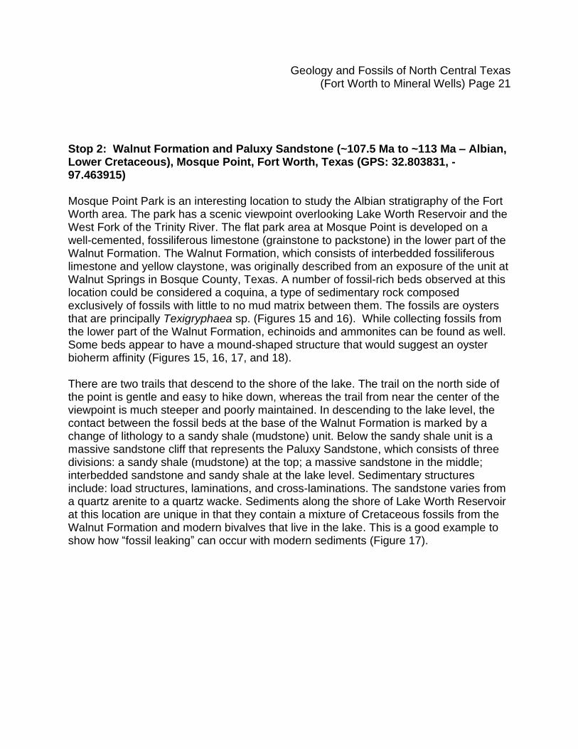
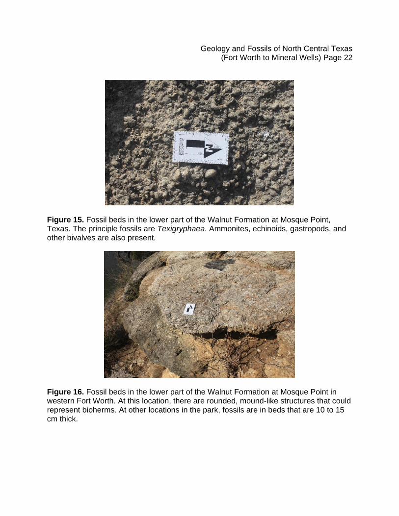
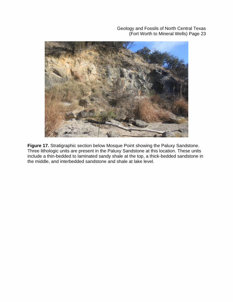
Stop 2: Walnut Formation and Paluxy Sandstone (~107.5 Ma to ~113 Ma – Albian, Lower Cretaceous), Mosque Point, Fort Worth, Texas (GPS: 32.803831, -97.463915) Mosque Point Park is an interesting location to study the Albian stratigraphy of the Fort Worth area. The park has a scenic viewpoint overlooking Lake Worth Reservoir and the West Fork of the Trinity River. The flat park area at Mosque Point is developed on a well-cemented, fossiliferous limestone (grainstone to packstone) in the lower part of the Walnut Formation. The Walnut Formation, which consists of interbedded fossiliferous limestone and yellow claystone, was originally described from an exposure of the unit at Walnut Springs in Bosque County, Texas. A number of fossil-rich beds observed at this location could be considered a coquina, a type of sedimentary rock composed exclusively of fossils with little to no mud matrix between them. The fossils are oysters that are principally Texigryphaea sp. (Figures 15 and 16). While collecting fossils from the lower part of the Walnut Formation, echinoids and ammonites can be found as well. Some beds appear to have a mound-shaped structure that would suggest an oyster bioherm affinity (Figures 15, 16, 17, and 18). There are two trails that descend to the shore of the lake. The trail on the north side of the point is gentle and easy to hike down, whereas the trail from near the center of the viewpoint is much steeper and poorly maintained. In descending to the lake level, the contact between the fossil beds at the base of the Walnut Formation is marked by a change of lithology to a sandy shale (mudstone) unit. Below the sandy shale unit is a massive sandstone cliff that represents the Paluxy Sandstone, which consists of three divisions: a sandy shale (mudstone) at the top; a massive sandstone in the middle; interbedded sandstone and sandy shale at the lake level. Sedimentary structures include: load structures, laminations, and cross-laminations. The sandstone varies from a quartz arenite to a quartz wacke. Sediments along the shore of Lake Worth Reservoir at this location are unique in that they contain a mixture of Cretaceous fossils from the Walnut Formation and modern bivalves that live in the lake. This is a good example to show how “fossil leaking” can occur with modern sediments (Figure 17).
Geology and Fossils of North Central Texas (Fort Worth to Mineral Wells) Page 22
Figure 15. Fossil beds in the lower part of the Walnut Formation at Mosque Point, Texas. The principle fossils are Texigryphaea. Ammonites, echinoids, gastropods, and other bivalves are also present.
Figure 16. Fossil beds in the lower part of the Walnut Formation at Mosque Point in western Fort Worth. At this location, there are rounded, mound-like structures that could represent bioherms. At other locations in the park, fossils are in beds that are 10 to 15 cm thick.
Geology and Fossils of North Central Texas (Fort Worth to Mineral Wells) Page 23
Figure 17. Stratigraphic section below Mosque Point showing the Paluxy Sandstone. Three lithologic units are present in the Paluxy Sandstone at this location. These units include a thin-bedded to laminated sandy shale at the top, a thick-bedded sandstone in the middle, and interbedded sandstone and shale at lake level.
Geology and Fossils of North Central Texas (Fort Worth to Mineral Wells) Page 24
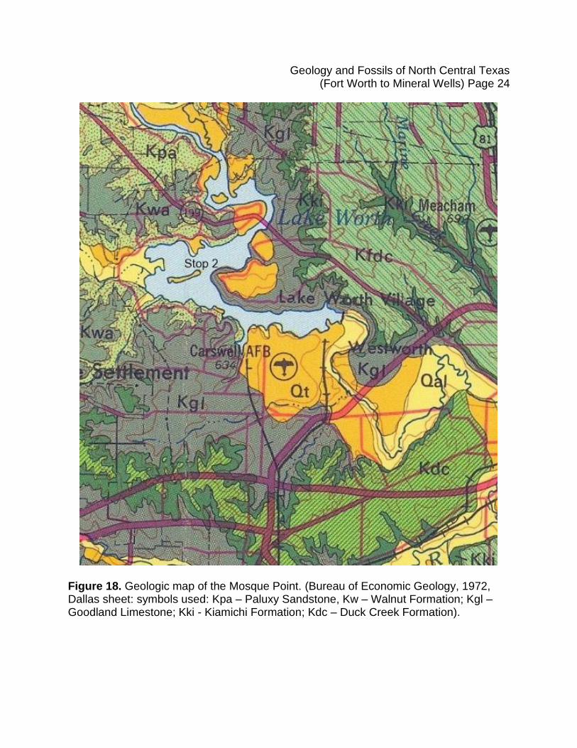
Figure 18. Geologic map of the Mosque Point. (Bureau of Economic Geology, 1972, Dallas sheet: symbols used: Kpa – Paluxy Sandstone, Kw – Walnut Formation; Kgl – Goodland Limestone; Kki - Kiamichi Formation; Kdc – Duck Creek Formation).
Geology and Fossils of North Central Texas (Fort Worth to Mineral Wells) Page 25
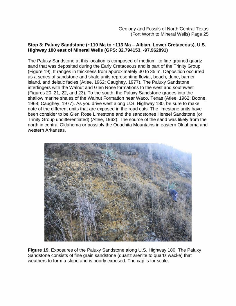
Stop 3: Paluxy Sandstone (~110 Ma to ~113 Ma – Albian, Lower Cretaceous), U.S. Highway 180 east of Mineral Wells (GPS: 32.794153, -97.962891) The Paluxy Sandstone at this location is composed of medium- to fine-grained quartz sand that was deposited during the Early Cretaceous and is part of the Trinity Group (Figure 19). It ranges in thickness from approximately 30 to 35 m. Deposition occurred as a series of sandstone and shale units representing fluvial, beach, dune, barrier island, and deltaic facies (Atlee, 1962; Caughey, 1977). The Paluxy Sandstone interfingers with the Walnut and Glen Rose formations to the west and southwest (Figures 20, 21, 22, and 23). To the south, the Paluxy Sandstone grades into the shallow marine shales of the Walnut Formation near Waco, Texas (Atlee, 1962; Boone, 1968; Caughey, 1977). As you drive west along U.S. Highway 180, be sure to make note of the different units that are exposed in the road cuts. The limestone units have been consider to be Glen Rose Limestone and the sandstones Hensel Sandstone (or Trinity Group undifferentiated) (Atlee, 1962). The source of the sand was likely from the north in central Oklahoma or possibly the Ouachita Mountains in eastern Oklahoma and western Arkansas.
Figure 19. Exposures of the Paluxy Sandstone along U.S. Highway 180. The Paluxy Sandstone consists of fine grain sandstone (quartz arenite to quartz wacke) that weathers to form a slope and is poorly exposed. The cap is for scale.
Geology and Fossils of North Central Texas (Fort Worth to Mineral Wells) Page 26
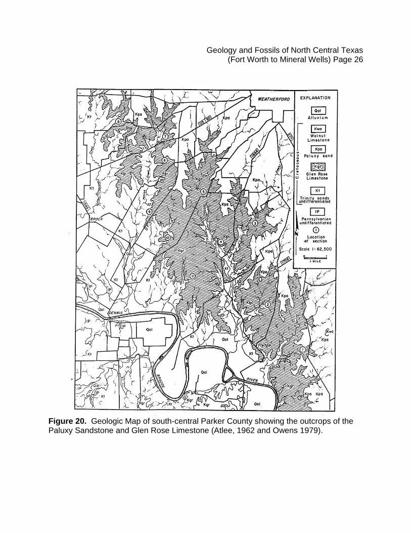
Figure 20. Geologic Map of south-central Parker County showing the outcrops of the Paluxy Sandstone and Glen Rose Limestone (Atlee, 1962 and Owens 1979).
Geology and Fossils of North Central Texas (Fort Worth to Mineral Wells) Page 27
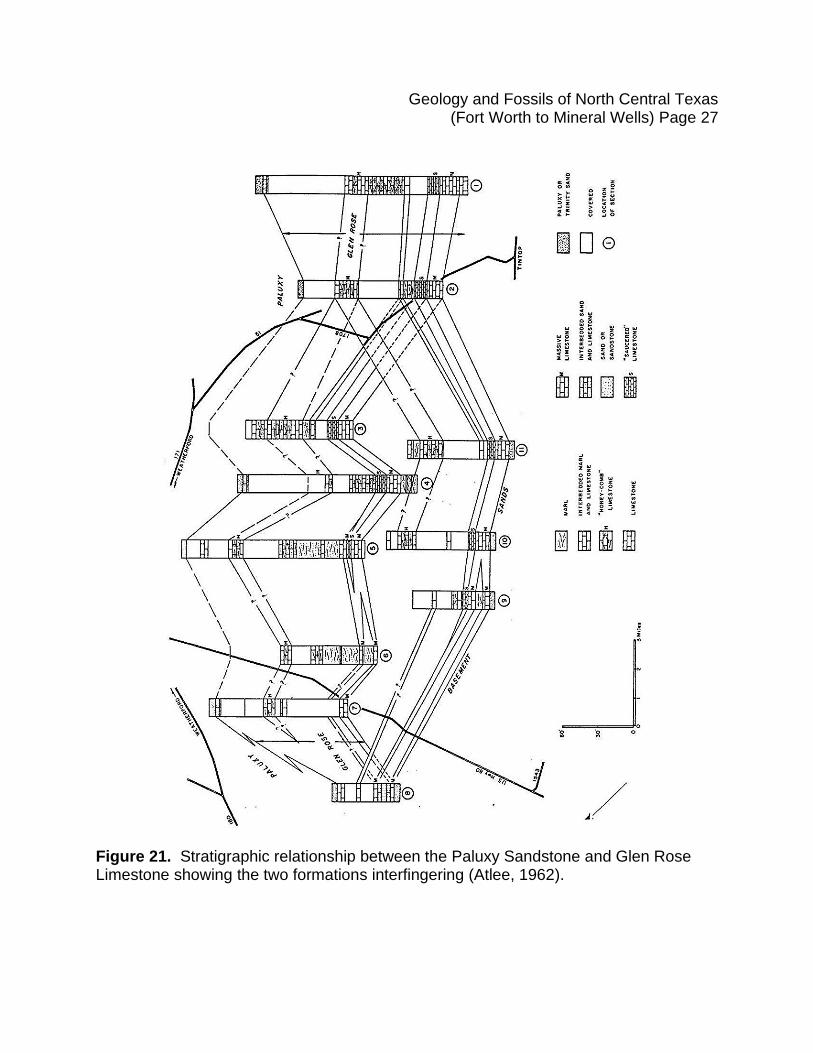
Figure 21. Stratigraphic relationship between the Paluxy Sandstone and Glen Rose Limestone showing the two formations interfingering (Atlee, 1962).
Geology and Fossils of North Central Texas (Fort Worth to Mineral Wells) Page 28
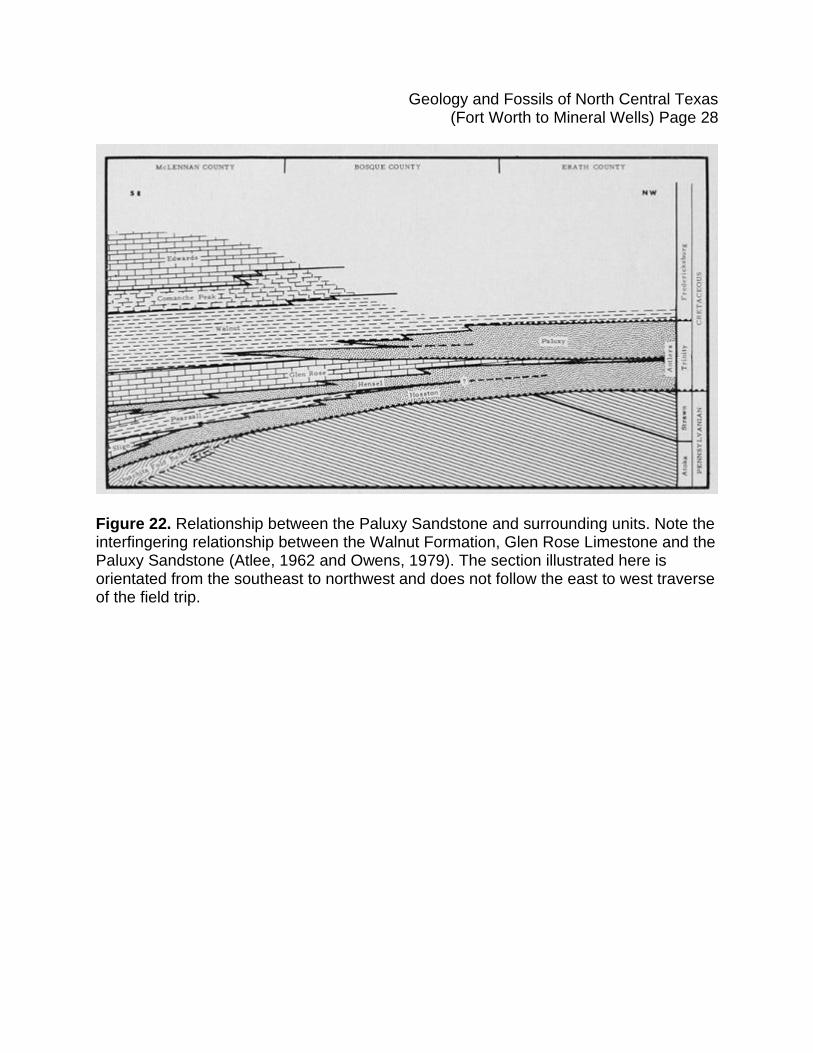
Figure 22. Relationship between the Paluxy Sandstone and surrounding units. Note the interfingering relationship between the Walnut Formation, Glen Rose Limestone and the Paluxy Sandstone (Atlee, 1962 and Owens, 1979). The section illustrated here is orientated from the southeast to northwest and does not follow the east to west traverse of the field trip.
Geology and Fossils of North Central Texas (Fort Worth to Mineral Wells) Page 29
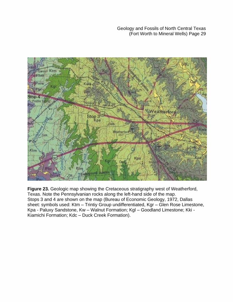
Figure 23. Geologic map showing the Cretaceous stratigraphy west of Weatherford, Texas. Note the Pennsylvanian rocks along the left-hand side of the map. Stops 3 and 4 are shown on the map (Bureau of Economic Geology, 1972, Dallas sheet: symbols used: Ktm – Trintiy Group undifferentiated, Kgr – Glen Rose Limestone, Kpa - Paluxy Sandstone, Kw – Walnut Formation; Kgl – Goodland Limestone; Kki - Kiamichi Formation; Kdc – Duck Creek Formation).
Geology and Fossils of North Central Texas (Fort Worth to Mineral Wells) Page 30
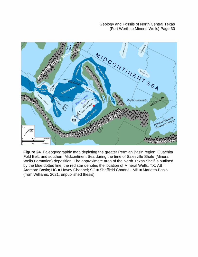
Figure 24. Paleogeographic map depicting the greater Permian Basin region, Ouachita Fold Belt, and southern Midcontinent Sea during the time of Salesville Shale (Mineral Wells Formation) deposition. The approximate area of the North Texas Shelf is outlined by the blue dotted line; the red star denotes the location of Mineral Wells, TX; AB = Ardmore Basin; HC = Hovey Channel; SC = Sheffield Channel; MB = Marietta Basin (from Williams, 2021, unpublished thesis).
Geology and Fossils of North Central Texas (Fort Worth to Mineral Wells) Page 31
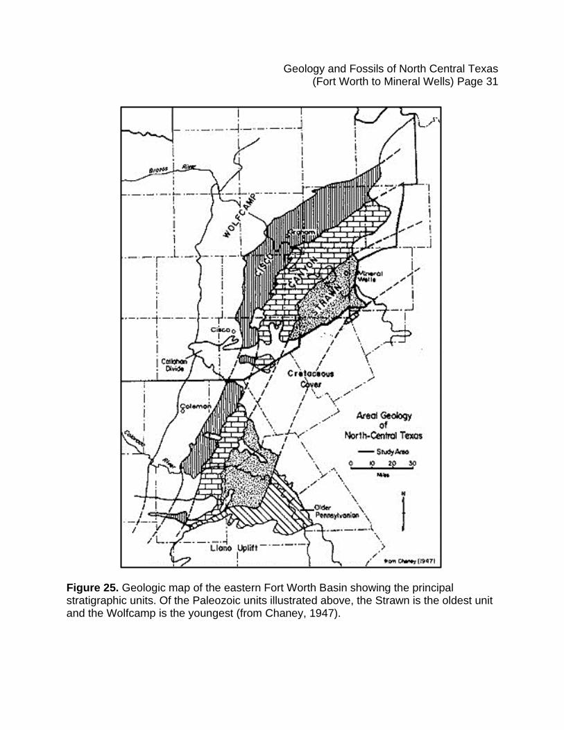
Figure 25. Geologic map of the eastern Fort Worth Basin showing the principal stratigraphic units. Of the Paleozoic units illustrated above, the Strawn is the oldest unit and the Wolfcamp is the youngest (from Chaney, 1947).
Geology and Fossils of North Central Texas (Fort Worth to Mineral Wells) Page 32
.
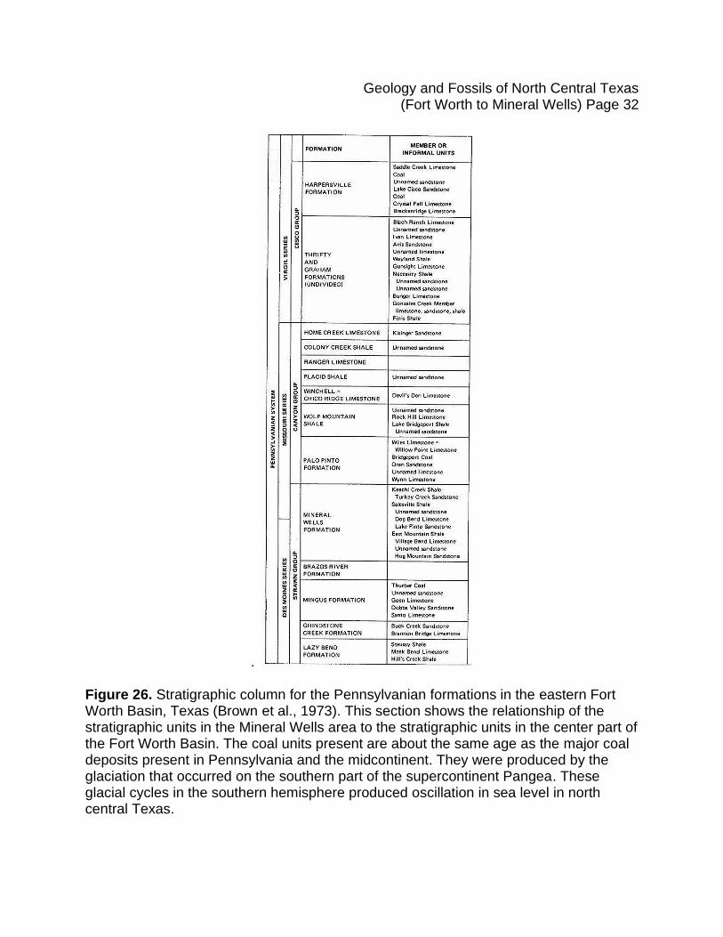
Figure 26. Stratigraphic column for the Pennsylvanian formations in the eastern Fort Worth Basin, Texas (Brown et al., 1973). This section shows the relationship of the stratigraphic units in the Mineral Wells area to the stratigraphic units in the center part of the Fort Worth Basin. The coal units present are about the same age as the major coal deposits present in Pennsylvania and the midcontinent. They were produced by the glaciation that occurred on the southern part of the supercontinent Pangea. These glacial cycles in the southern hemisphere produced oscillation in sea level in north central Texas.
Geology and Fossils of North Central Texas (Fort Worth to Mineral Wells) Page 33
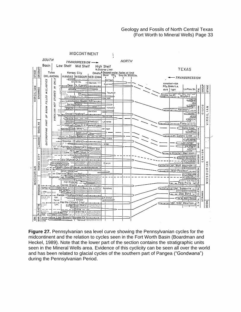
Figure 27. Pennsylvanian sea level curve showing the Pennsylvanian cycles for the midcontinent and the relation to cycles seen in the Fort Worth Basin (Boardman and Heckel, 1989). Note that the lower part of the section contains the stratigraphic units seen in the Mineral Wells area. Evidence of this cyclicity can be seen all over the world and has been related to glacial cycles of the southern part of Pangea (“Gondwana”) during the Pennsylvanian Period.
Geology and Fossils of North Central Texas (Fort Worth to Mineral Wells) Page 34
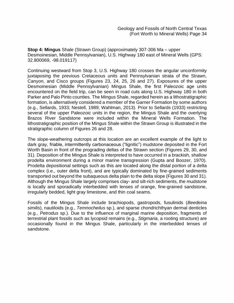
Stop 4: Mingus Shale (Strawn Group) (approximately 307-306 Ma – upper Desmoinesian, Middle Pennsylvanian), U.S. Highway 180 east of Mineral Wells (GPS: 32.800069, -98.019117)
Continuing westward from Stop 3, U.S. Highway 180 crosses the angular unconformity juxtaposing the previous Cretaceous units and Pennsylvanian strata of the Strawn, Canyon, and Cisco groups (Figures 23, 24, 25, 26 and 27). Exposures of the upper Desmoinesian (Middle Pennsylvanian) Mingus Shale, the first Paleozoic age units encountered on the field trip, can be seen in road cuts along U.S. Highway 180 in both Parker and Palo Pinto counties. The Mingus Shale, regarded herein as a lithostratigraphic formation, is alternatively considered a member of the Garner Formation by some authors (e.g., Sellards, 1933; Nestell, 1989; Wahlman, 2013). Prior to Sellards (1933) restricting several of the upper Paleozoic units in the region, the Mingus Shale and the overlying Brazos River Sandstone were included within the Mineral Wells Formation. The lithostratigraphic position of the Mingus Shale within the Strawn Group is illustrated in the stratigraphic column of Figures 26 and 28. The slope-weathering outcrops at this location are an excellent example of the light to dark gray, friable, intermittently carbonaceous (“lignitic”) mudstone deposited in the Fort Worth Basin in front of the prograding deltas of the Strawn section (Figures 29, 30, and 31). Deposition of the Mingus Shale is interpreted to have occurred in a brackish, shallow prodelta environment during a minor marine transgression (Gupta and Boozer, 1970). Prodelta depositional settings such as this are located along the distal portion of a delta complex (i.e., outer delta front), and are typically dominated by fine-grained sediments transported out beyond the subaqueous delta plain to the delta slope (Figures 30 and 31). Although the Mingus Shale largely comprises clay- and silt-rich sediments, the mudstone is locally and sporadically interbedded with lenses of orange, fine-grained sandstone, irregularly bedded, light gray limestone, and thin coal seams. Fossils of the Mingus Shale include brachiopods, gastropods, fusulinids (Beedeina similis), nautiloids (e.g., Temnocheilus sp.), and sparse chondrichthyan dermal denticles (e.g., Petrodus sp.). Due to the influence of marginal marine deposition, fragments of terrestrial plant fossils such as lycopsid remains (e.g., Stigmaria, a rooting structure) are occasionally found in the Mingus Shale, particularly in the interbedded lenses of sandstone.
Geology and Fossils of North Central Texas (Fort Worth to Mineral Wells) Page 35
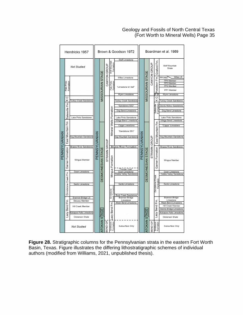
Figure 28. Stratigraphic columns for the Pennsylvanian strata in the eastern Fort Worth Basin, Texas. Figure illustrates the differing lithostratigraphic schemes of individual authors (modified from Williams, 2021, unpublished thesis).
Geology and Fossils of North Central Texas (Fort Worth to Mineral Wells) Page 36
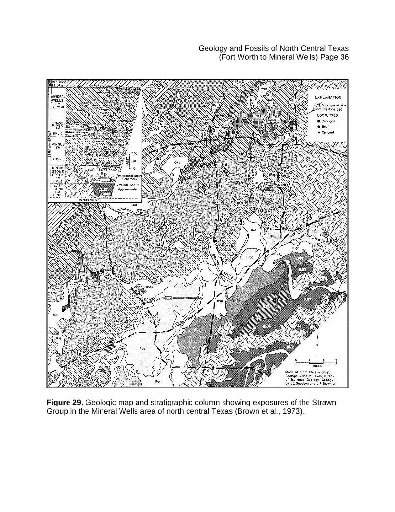
Figure 29. Geologic map and stratigraphic column showing exposures of the Strawn Group in the Mineral Wells area of north central Texas (Brown et al., 1973).
Geology and Fossils of North Central Texas (Fort Worth to Mineral Wells) Page 37
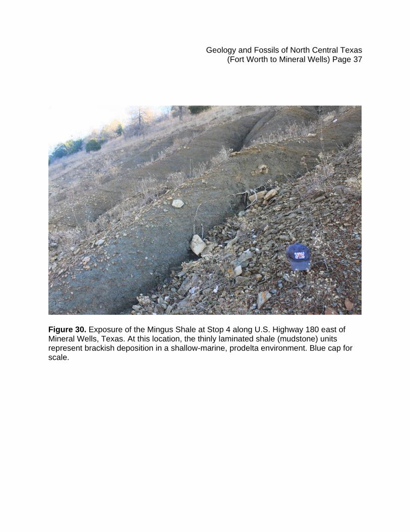
Figure 30. Exposure of the Mingus Shale at Stop 4 along U.S. Highway 180 east of Mineral Wells, Texas. At this location, the thinly laminated shale (mudstone) units represent brackish deposition in a shallow-marine, prodelta environment. Blue cap for scale.
Geology and Fossils of North Central Texas (Fort Worth to Mineral Wells) Page 38
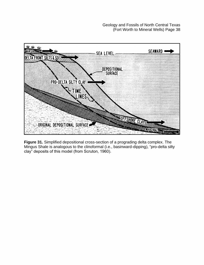
Figure 31. Simplified depositional cross-section of a prograding delta complex. The Mingus Shale is analogous to the clinoformal (i.e., basinward-dipping), “pro-delta silty clay” deposits of this model (from Scruton, 1960).
Geology and Fossils of North Central Texas (Fort Worth to Mineral Wells) Page 39
Stop 5. Brazos River Sandstone (Strawn Group) (approximately 307-306 Ma – upper Desmoinesian, Middle Pennsylvanian), U.S. Highway 180 east of Mineral Wells (GPS: 32.798077, -98.028345) Stop 5 is located east of Mineral Wells on U.S. 180. At this location, the previously discussed Mingus Shale (Stop 4) forms the gray, lower slope and the Brazos River Sandstone forms the bluff on the north (westbound) side of the highway. Like the underlying Mingus Shale, the Brazos River Sandstone is variably ranked in the stratigraphic literature as either a formation or a member of the Garner Formation (depending on the author) (Figure 32, and 33). The stratigraphic position of the Brazos River Sandstone within the upper Paleozoic section of Palo Pinto County is illustrated in Figures 26, and 28. The Brazos River Sandstone is primarily composed of tan to red-brown, subangular quartz sand grains bound by siliceous cement and, to a lesser extent, hematite cement (Briggs, 1963). Lenses of conglomerate are commonly interbedded within the quartzose sandstone, with variegated, subangular to angular, fine to very coarse gravel clasts consisting of chert, quartzite, novaculite, and shale shed from the uplift of the Ouachita Mountains. Intervals with the highest concentrations of conglomeratic sediments are interpreted as approximations for the position of the paleoshoreline. Across Palo Pinto County, the volume and frequency of conglomeratic intervals decreases to the west, north, and northeast as the unit grades into beach sand and ultimately shallow marine, calcareous-cemented marine sandstone. Such a lithofacies distribution suggests an Ouachita highlands sediment source located to the southeast of Palo Pinto County that flowed generally northwest into the Fort Worth Basin. This paleocurrent assessment is also supported by dip-direction measurements from cross-bedding structures within both sand and conglomeratic units of the Brazos River Sandstone (Briggs, 1963). As the fluvio-deltaic complex of distributary channels, beaches, bars, and delta front environments prograded to the west and northwest, the paleoshoreline of the Fort Worth Basin regressed and the sandy/conglomeratic sediments Brazos River Sandstone buried the previously deposited prodelta sediments of the Mingus Shale. Generalized models of this depositional setting are illustrated in Figures 34, 35 and 36. Due to the dominantly terrestrial origin of the Brazos River Sandstone, the unit mostly lacks marine fossils (Briggs, 1963). Exceptions include the distal, shallow marine portions and thin, transgressive arenaceous (“sandy”) limestone beds. The sparse marine invertebrate fauna includes disarticulated crinoid columnals, brachiopod fragments, and fusulinids (Beedeina brazosensis; B. whitakeri) (Reynolds, 1953; Nestell, 1989). In the Mineral Wells area, where the sandstone is almost strictly fluvio-deltaic in nature, the most common fossils are casts of plant remains (e.g., Lepidodendron, Stigmaria) (Figure 37). Some well-preserved log casts of Lepidodendron with lengths in excess of three meters have been recovered from
Geology and Fossils of North Central Texas (Fort Worth to Mineral Wells) Page 40
conglomeratic intervals of the unit (Briggs, 1963).
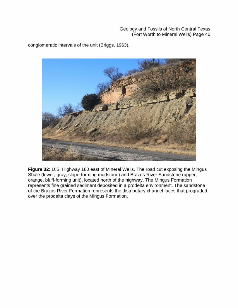
Figure 32: U.S. Highway 180 east of Mineral Wells. The road cut exposing the Mingus Shale (lower, gray, slope-forming mudstone) and Brazos River Sandstone (upper, orange, bluff-forming unit), located north of the highway. The Mingus Formation represents fine grained sediment deposited in a prodelta environment. The sandstone of the Brazos River Formation represents the distributary channel faces that prograded over the prodelta clays of the Mingus Formation.
Geology and Fossils of North Central Texas (Fort Worth to Mineral Wells) Page 41
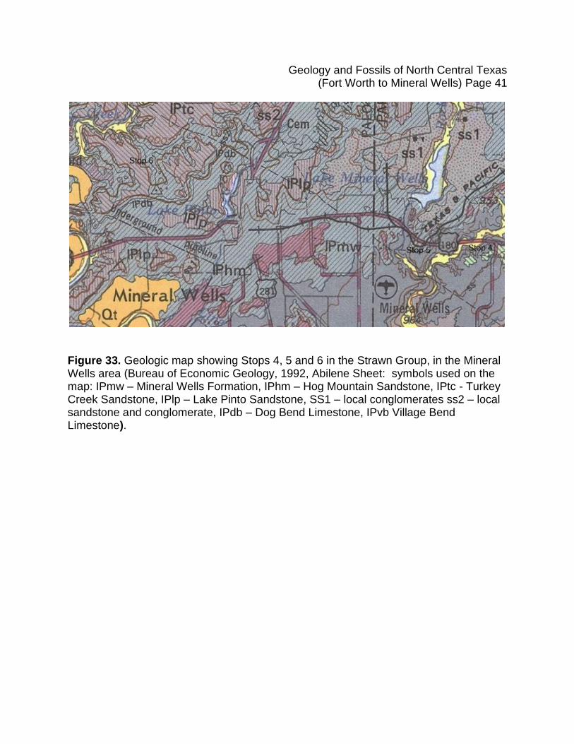
Figure 33. Geologic map showing Stops 4, 5 and 6 in the Strawn Group, in the Mineral Wells area (Bureau of Economic Geology, 1992, Abilene Sheet: symbols used on the map: IPmw – Mineral Wells Formation, IPhm – Hog Mountain Sandstone, IPtc - Turkey Creek Sandstone, IPlp – Lake Pinto Sandstone, SS1 – local conglomerates ss2 – local sandstone and conglomerate, IPdb – Dog Bend Limestone, IPvb Village Bend Limestone).
Geology and Fossils of North Central Texas (Fort Worth to Mineral Wells) Page 42
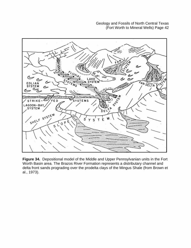
Figure 34. Depositional model of the Middle and Upper Pennsylvanian units in the Fort Worth Basin area. The Brazos River Formation represents a distributary channel and delta front sands prograding over the prodelta clays of the Mingus Shale (from Brown et al., 1973).
Geology and Fossils of North Central Texas (Fort Worth to Mineral Wells) Page 43
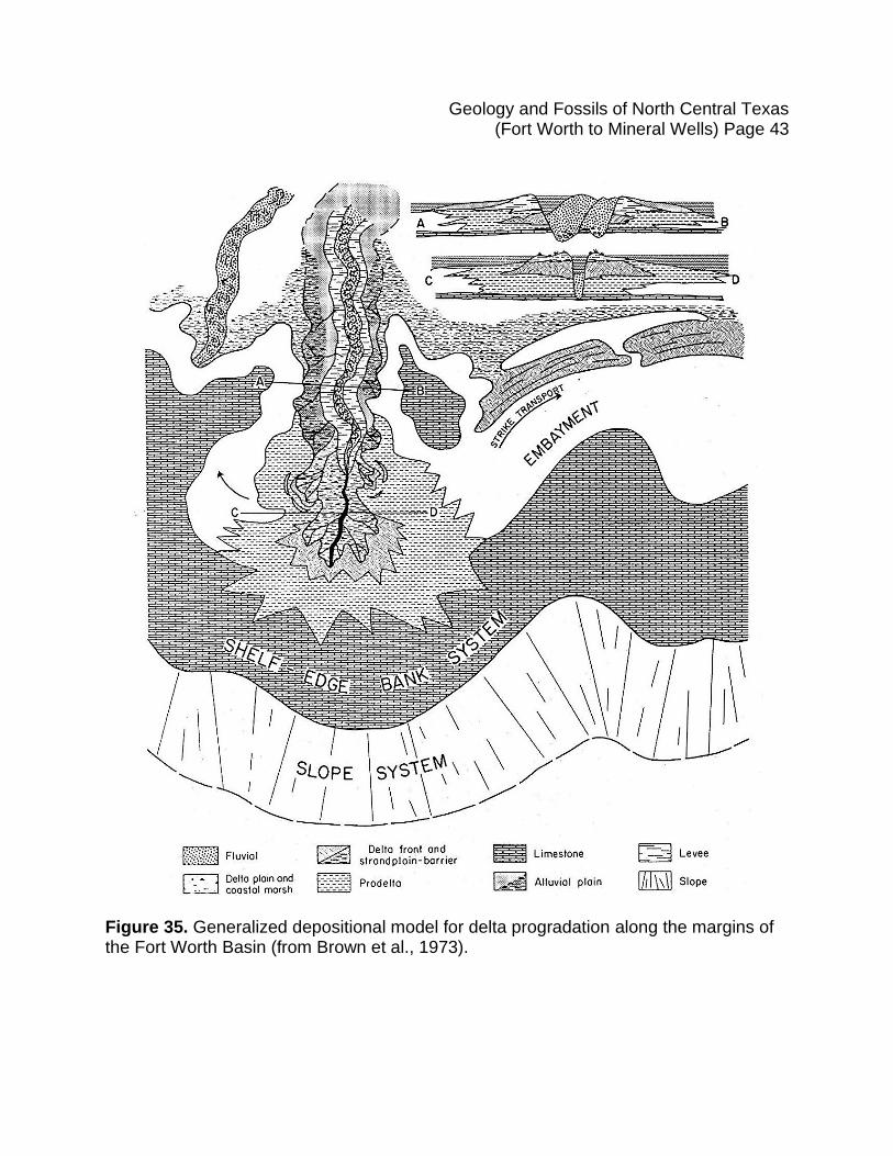
Figure 35. Generalized depositional model for delta progradation along the margins of the Fort Worth Basin (from Brown et al., 1973).
Geology and Fossils of North Central Texas (Fort Worth to Mineral Wells) Page 44
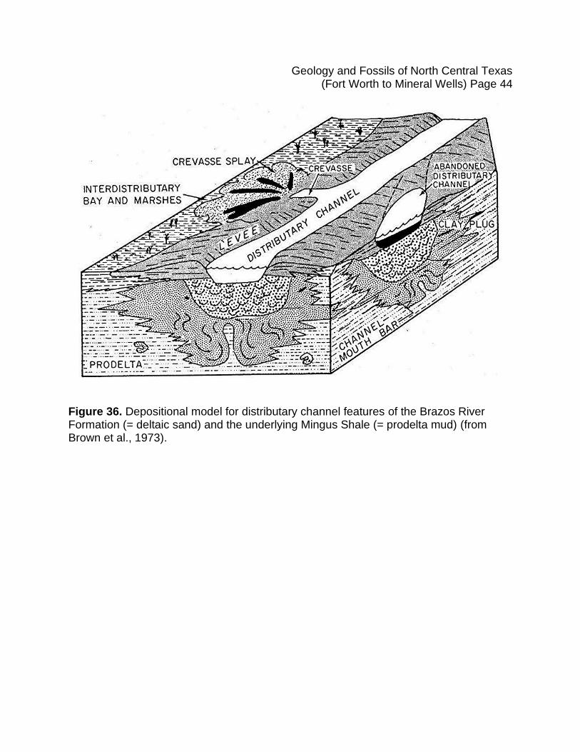
Figure 36. Depositional model for distributary channel features of the Brazos River Formation (= deltaic sand) and the underlying Mingus Shale (= prodelta mud) (from Brown et al., 1973).
Geology and Fossils of North Central Texas (Fort Worth to Mineral Wells) Page 45
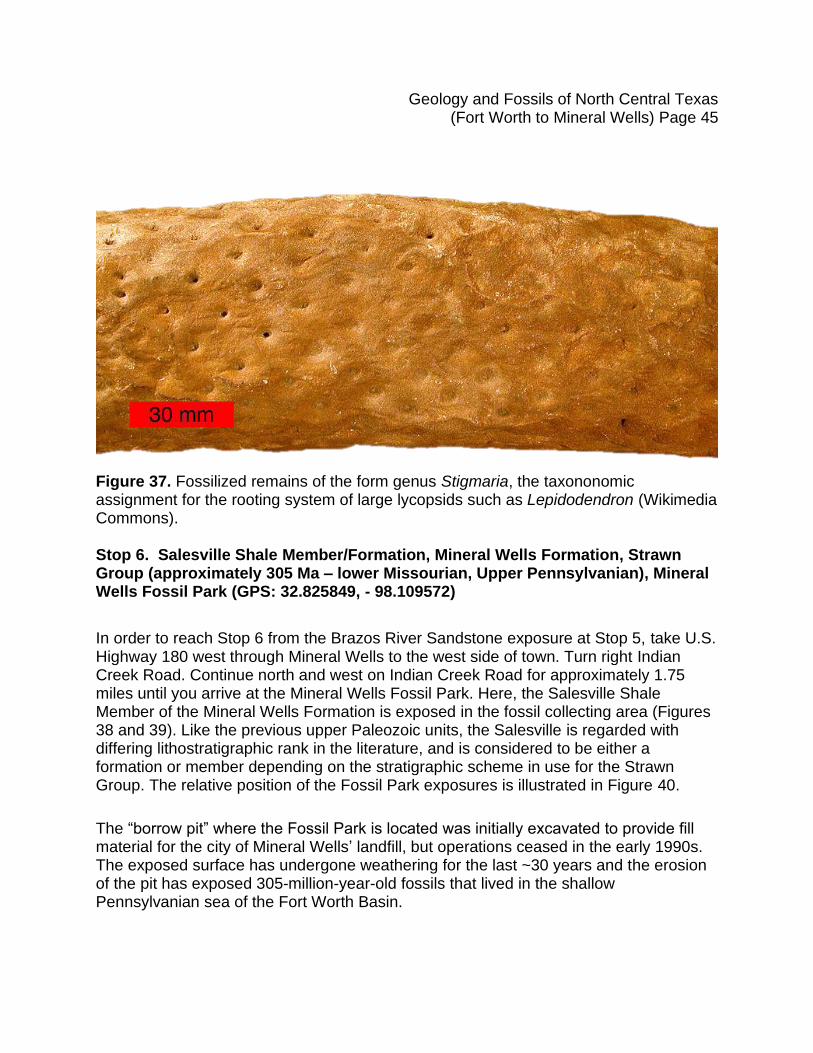
Figure 37. Fossilized remains of the form genus Stigmaria, the taxononomic assignment for the rooting system of large lycopsids such as Lepidodendron (Wikimedia Commons). Stop 6. Salesville Shale Member/Formation, Mineral Wells Formation, Strawn Group (approximately 305 Ma – lower Missourian, Upper Pennsylvanian), Mineral Wells Fossil Park (GPS: 32.825849, - 98.109572)
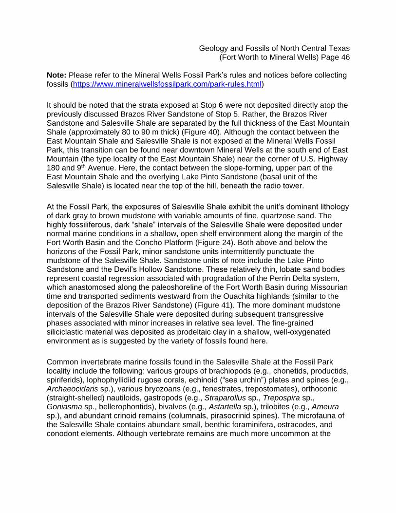
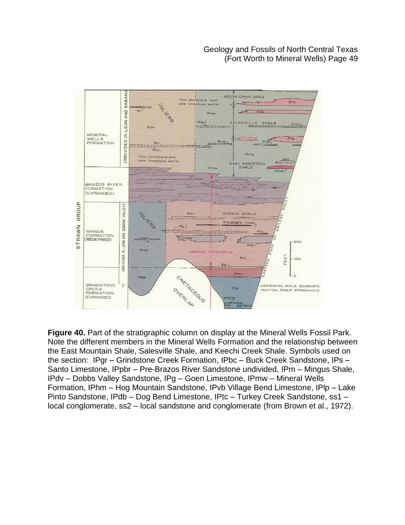
In order to reach Stop 6 from the Brazos River Sandstone exposure at Stop 5, take U.S. Highway 180 west through Mineral Wells to the west side of town. Turn right Indian Creek Road. Continue north and west on Indian Creek Road for approximately 1.75 miles until you arrive at the Mineral Wells Fossil Park. Here, the Salesville Shale Member of the Mineral Wells Formation is exposed in the fossil collecting area (Figures 38 and 39). Like the previous upper Paleozoic units, the Salesville is regarded with differing lithostratigraphic rank in the literature, and is considered to be either a formation or member depending on the stratigraphic scheme in use for the Strawn Group. The relative position of the Fossil Park exposures is illustrated in Figure 40.
The “borrow pit” where the Fossil Park is located was initially excavated to provide fill material for the city of Mineral Wells’ landfill, but operations ceased in the early 1990s. The exposed surface has undergone weathering for the last ~30 years and the erosion of the pit has exposed 305-million-year-old fossils that lived in the shallow Pennsylvanian sea of the Fort Worth Basin.
Geology and Fossils of North Central Texas (Fort Worth to Mineral Wells) Page 46
Note: Please refer to the Mineral Wells Fossil Park’s rules and notices before collecting fossils (https://www.mineralwellsfossilpark.com/park-rules.html)
It should be noted that the strata exposed at Stop 6 were not deposited directly atop the previously discussed Brazos River Sandstone of Stop 5. Rather, the Brazos River Sandstone and Salesville Shale are separated by the full thickness of the East Mountain Shale (approximately 80 to 90 m thick) (Figure 40). Although the contact between the East Mountain Shale and Salesville Shale is not exposed at the Mineral Wells Fossil Park, this transition can be found near downtown Mineral Wells at the south end of East Mountain (the type locality of the East Mountain Shale) near the corner of U.S. Highway 180 and 9th Avenue. Here, the contact between the slope-forming, upper part of the East Mountain Shale and the overlying Lake Pinto Sandstone (basal unit of the Salesville Shale) is located near the top of the hill, beneath the radio tower.
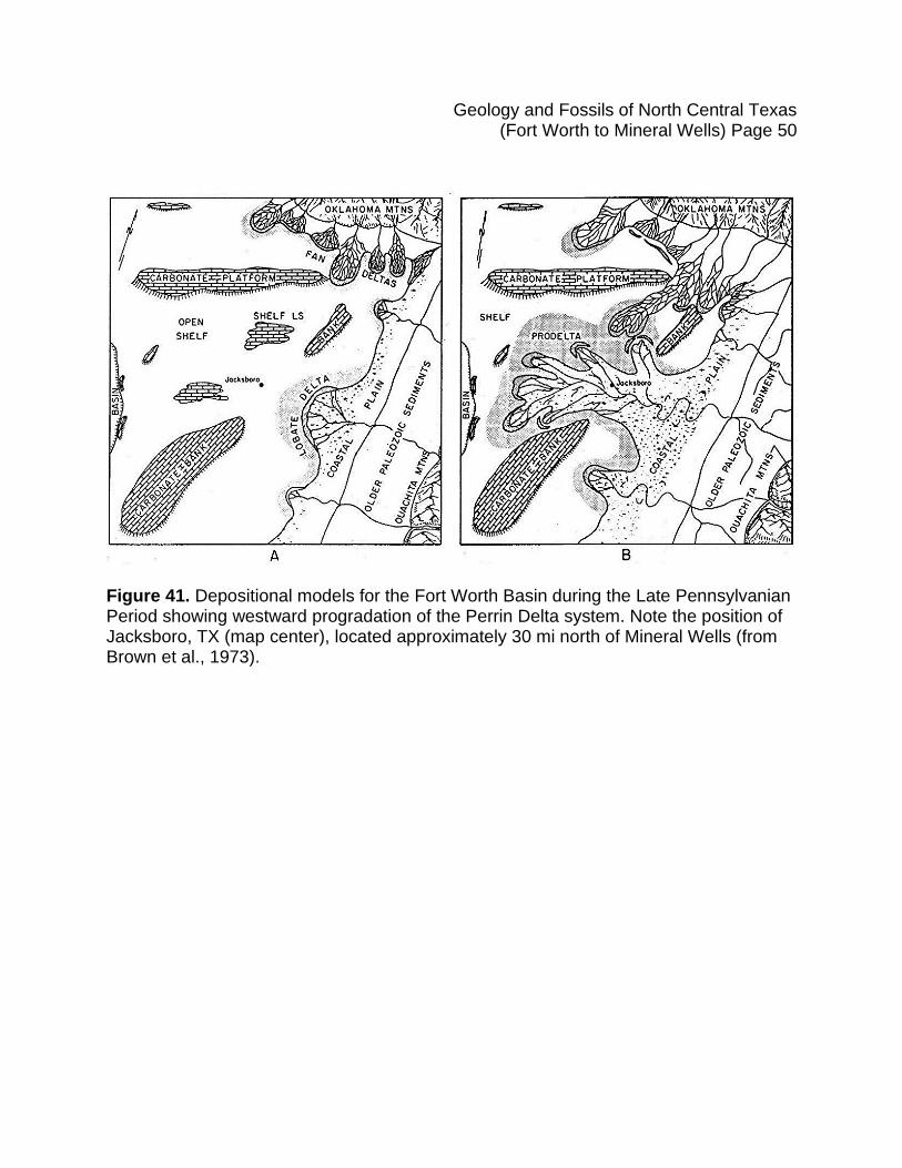
At the Fossil Park, the exposures of Salesville Shale exhibit the unit’s dominant lithology of dark gray to brown mudstone with variable amounts of fine, quartzose sand. The highly fossiliferous, dark “shale” intervals of the Salesville Shale were deposited under normal marine conditions in a shallow, open shelf environment along the margin of the Fort Worth Basin and the Concho Platform (Figure 24). Both above and below the horizons of the Fossil Park, minor sandstone units intermittently punctuate the mudstone of the Salesville Shale. Sandstone units of note include the Lake Pinto Sandstone and the Devil’s Hollow Sandstone. These relatively thin, lobate sand bodies represent coastal regression associated with progradation of the Perrin Delta system, which anastomosed along the paleoshoreline of the Fort Worth Basin during Missourian time and transported sediments westward from the Ouachita highlands (similar to the deposition of the Brazos River Sandstone) (Figure 41). The more dominant mudstone intervals of the Salesville Shale were deposited during subsequent transgressive phases associated with minor increases in relative sea level. The fine-grained siliciclastic material was deposited as prodeltaic clay in a shallow, well-oxygenated environment as is suggested by the variety of fossils found here.
Common invertebrate marine fossils found in the Salesville Shale at the Fossil Park locality include the following: various groups of brachiopods (e.g., chonetids, productids, spiriferids), lophophyllidiid rugose corals, echinoid (“sea urchin”) plates and spines (e.g., Archaeocidaris sp.), various bryozoans (e.g., fenestrates, trepostomates), orthoconic (straight-shelled) nautiloids, gastropods (e.g., Straparollus sp., Trepospira sp., Goniasma sp., bellerophontids), bivalves (e.g., Astartella sp.), trilobites (e.g., Ameura sp.), and abundant crinoid remains (columnals, pirasocrinid spines). The microfauna of the Salesville Shale contains abundant small, benthic foraminifera, ostracodes, and conodont elements. Although vertebrate remains are much more uncommon at the
Geology and Fossils of North Central Texas (Fort Worth to Mineral Wells) Page 47
Fossil Park, chondrichthyan (“shark”) remains can occasionally be found, including Petalodus teeth and fragments of Ctenacanthus dorsal fin spines.
For photos of fossils that can be found at the Mineral Wells Fossil Park, refer to the official Mineral Wells Fossil Park website (What Can I Find tab).
https://www.mineralwellsfossilpark.com/what-can-i-find.html
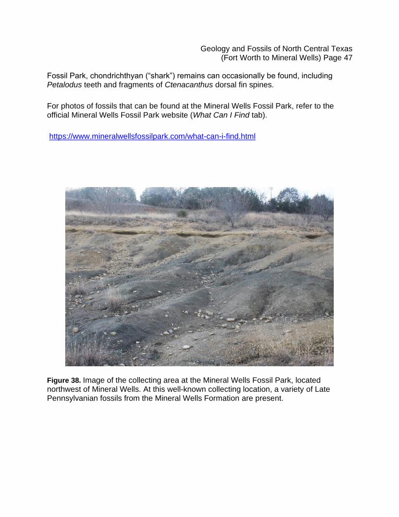
Figure 38. Image of the collecting area at the Mineral Wells Fossil Park, located northwest of Mineral Wells. At this well-known collecting location, a variety of Late Pennsylvanian fossils from the Mineral Wells Formation are present.
Geology and Fossils of North Central Texas (Fort Worth to Mineral Wells) Page 48
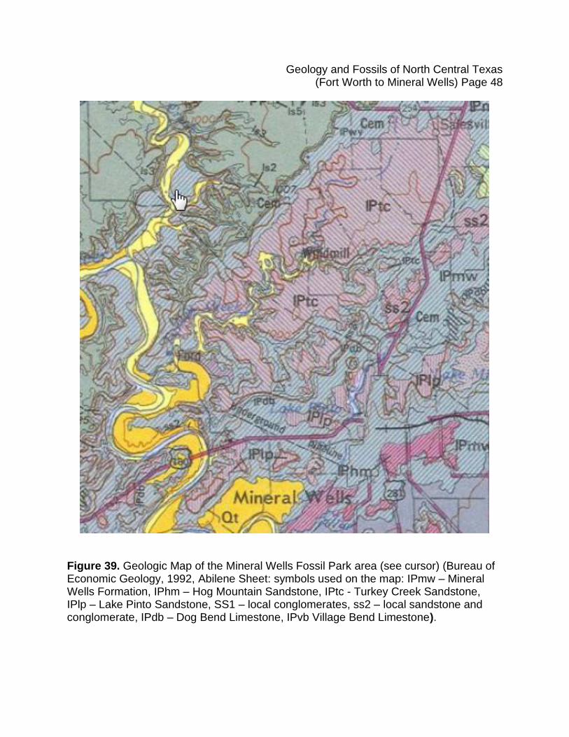
Figure 39. Geologic Map of the Mineral Wells Fossil Park area (see cursor) (Bureau of Economic Geology, 1992, Abilene Sheet: symbols used on the map: IPmw – Mineral Wells Formation, IPhm – Hog Mountain Sandstone, IPtc - Turkey Creek Sandstone, IPlp – Lake Pinto Sandstone, SS1 – local conglomerates, ss2 – local sandstone and conglomerate, IPdb – Dog Bend Limestone, IPvb Village Bend Limestone).
Geology and Fossils of North Central Texas (Fort Worth to Mineral Wells) Page 49
Figure 40. Part of the stratigraphic column on display at the Mineral Wells Fossil Park. Note the different members in the Mineral Wells Formation and the relationship between the East Mountain Shale, Salesville Shale, and Keechi Creek Shale. Symbols used on the section: IPgr – Grindstone Creek Formation, IPbc – Buck Creek Sandstone, IPs – Santo Limestone, IPpbr – Pre-Brazos River Sandstone undivided, IPm – Mingus Shale, IPdv – Dobbs Valley Sandstone, IPg – Goen Limestone, IPmw – Mineral Wells Formation, IPhm – Hog Mountain Sandstone, IPvb Village Bend Limestone, IPlp – Lake Pinto Sandstone, IPdb – Dog Bend Limestone, IPtc – Turkey Creek Sandstone, ss1 – local conglomerate, ss2 – local sandstone and conglomerate (from Brown et al., 1972).
Geology and Fossils of North Central Texas (Fort Worth to Mineral Wells) Page 50
Figure 41. Depositional models for the Fort Worth Basin during the Late Pennsylvanian Period showing westward progradation of the Perrin Delta system. Note the position of Jacksboro, TX (map center), located approximately 30 mi north of Mineral Wells (from Brown et al., 1973).
Geology and Fossils of North Central Texas (Fort Worth to Mineral Wells) Page 51
References Cited
Atlee, W. A. 1962. The Lower Cretaceous Paluxy Sand in Central Texas. Baylor Geological Studies Bulletin, 2: 25 pp. Barnes, V.E. (project director). 1987. Geologic Atlas of Texas, Dallas Sheet [revision of 1972 ed.]: University of Texas-Austin, Bureau of Economic Geology Geologic Atlas of Texas, 1 sheet, [10 p., revised 1988], scale 1:250,000, Gayle Scott memorial edition. Boardman, D. R., & Heckel, P. H. 1989. Glacial-eustatic sea-level curve for early Upper Pennsylvanian sequence in north-central Texas and biostratigraphic correlation with curve for midcontinent North America: In Middle and Late Pennsylvanian Chronostratigraphic Boundaries in North-Central Texas: Glacial-Eustatic Events, Biostratigraphy, and Paleoecology, A Guidebook with Contributed Papers, GSA South-Central Annual Meeting: p. 63-73. Boone, P. A. 1968. Stratigraphy of the Basal Trinity (Lower Cretaceous) Sands, Central Texas. Baylor Geological Studies Bulletin, 15: 64 pp. Booth, C. C. 1956. Geology of Chalk Mountain Quadrangle, Bosque, Earth, Hamilton and Somervell counties, Texas. Unpublished Master’s thesis, University of Texas, Austin. Brown, L. F. Jr., Goodson, J. L., & Harwood, P. 1972. Geologic Atlas of Texas, Abilene Sheet, map scale 1:250,000. The University of Texas at Austin, Bureau of Economic Geology. Brown, L. F. Jr., Cleaves, A. W., & Erxleben, A. W. 1973. Pennsylvanian depositional systems in North-Central Texas. Bureau of Economic Geology Guidebook, 14: 122 pp. Bureau of Economic Geology. 1972. Dallas sheet, Geologic Atlas of Texas, Bureau of Economic Geology, University of Texas at Austin, scale 1:250,000, https://ngmdb.usgs.gov/Prodesc/proddesc_19391.htm.
Bureau of Economic Geology. 1992. Abilene Sheet, Geologic Map of Texas: University of Texas at Austin, Hartmann, B.M. and Scranton, D.F., scale 1:250,000, https://ngmdb.usgs.gov/Prodesc/proddesc_19376.htm.
Chaney, M.G. 1947. Pennsylvanian classification and correlation problems in North-Central Texas. The Journal of Geology, 55(3): p. 202-219.
Geology and Fossils of North Central Texas (Fort Worth to Mineral Wells) Page 52
Caughey, C. A. 1977. Depositional systems in the Paluxy Formation (Lower Cretaceous), Northeast Texas – Oil, Gas, and Groundwater Resources. Bureau of Economic Geology, Geological Circular 77-8: 59 pp. Dawson, W. C., McNulty, C. L., Reaser, D. F., Leaders. 1979. Fieldtrip Guidebook for Stratigraphy and Structure of Selected Upper Cretaceous Rocks in Northeast Texas. Texas Academy of Science 82nd Annual Meeting, Arlington, Texas: p. 1 - 48. Dodge, C. F. 1968. Stratigraphy of the Woodbine formation, Tarrant County, Texas, Field Trip Guidebook, South-Central Section of the Geological Society of America: p. 76. Grayson, R. C. Jr. & Trite, E. L. 1988. Middle and upper Pennsylvanian (Atokan-Missonrian) strata in the Colorado River Valley, South-Central Section of the Geological society of America Decade of north American Geology, South Central Section, 4: p. 343-350. Hendricks, C.L. 1957. Geology of Parker County, Texas: University of Texas Publication, No. 5724: 67 p. Nestell, M. K. 1989. The Desmoinesian-Early Missourian fusulinacean succession in the Brazos River Valley, north-central Texas. In Middle and Late Pennsylvanian Chronostratigraphic Boundaries in North-Central Texas: Glacial-Eustatic Events, Biostratigraphy, and Paleoecology, A Guidebook with Contributed Papers, GSA South-Central Annual Meeting: p. 95-113. Nickell, C.O. 1938. Stratigraphy of the Canyon and Cisco groups on Colorado River in Brown and Coleman Counties, Texas, in Lee, Wallace and others, Stratigraphic and Paleontologic Studies of the Pennsylvanian and Permian rocks in north-central Texas: University of Texas-Austin, Bureau of Economic Geology Publication, no. 3801: p. 91-138, (incl. geologic map). Owens, T. M. 1979. The Paluxy Sand in North-Central Texas: Baylor Geological Studies, Bull. 36: p. 37. Plummer, F.B. 1919. Preliminary paper on the stratigraphy of the Pennsylvanian formations of north-central Texas, with discussion: American Association of Petroleum Geologists Bulletin, 3(1): p. 132-150. Plummer, F.B. & Moore, R.C. 1922. Pennsylvanian stratigraphy of north-central Texas: Journal of Geology, 30(1): p. 18-42.
Geology and Fossils of North Central Texas (Fort Worth to Mineral Wells) Page 53
Scruton, P. C. 1960. Delta building and the deltaic sequence. Recent Sediments, Northwest Gulf of Mexico, AAPG Special Volume: p. 82-102. Trite, E. L. & Grayson, R. C. Jr. 1988. Middle and late Pennsylvanian Rocks, North-Central-Texas, Geologic Society of America, Centennial Field Guide, 4: p.317-322. U. S Geologic Names Lexicon (USGS Bull. 896, P. 1380); supplemental information from GNU records (USGS DDS-6; Denver GNULEX). U. S. Geological Survey, 2021, Texas Geology Web Map Viewer, accessed February 8, 2021, at URL https://txpub.usgs.gov/txgeology/. Wahlman, G. P. 2013. Pennsylvanian to Lower Permian (Desmoienesian-Wolfcampian) fusulinid biostratigraphy of Midcontinent North America. Stratigraphy, 10(1-2): p. 73-104. Williams, B. A. 2021. The microfossil association of the upper part of the Salesville Formation (lower Missourian, Pennsylvanian) near Mineral Wells, North-Central Texas. Unpublished Master’s thesis, University of Texas, Arlington. Winkler, D. A., Murry, P. A. & Jacobs, L. L., Editors. 1989. Field Guide To The Vertebrate Paleontology Of The Trinity Group, Lower Cretaceous Of Central Texas. (Institute for the Study of Earth and Man, Southern Methodist University, Dallas, Texas.) Winton, W. M. & Adkins, W. S. 1919. The Geology of Tarrant County, University of Texas Bulletin No. 1931: p. 86.