geology and ground-water resources of … · the valley formed by the gila river and san simon...
TRANSCRIPT
I Jlinera! Classification Branch
If yon do not need this report after it has served your purpose, please return it to the Geological Survey, using the official mailing label at the end
UNITED STATES DEPARTMENT OF THE INTERIOR
GEOLOGY AND GROUND-WATERRESOURCES OF THE VALLEY OF
GILA RIVER AND SAN SIMONCREEK, ARIZONA
GEOLOGICAL SURVEY WATER-SUPPLY PAPER 796 F
/ - J. ->

UNITED STATES DEPARTMENT OF THE INTERIOR Harold L. Ickes, Secretary
GEOLOGICAL SURVEY W. C. Mendenhall, Director
Water-Supply Paper 796 F
GEOLOGY AND GEOUND-WATEB BESOUBCESOF THE VALLEY OF GILA BIVEB AND
SAN SIMON CBEEK, GBAHAMCOUNTY, ABIZONA
BY
MAXWELL M. KNECHTEL
WITH A SECTION ON THE
CHEMICAL CHARACTER OF THE GROUND WATER
BY
E. W. LOHR
Contributions to the hydrology of the United States, 1937 (Pages 181-222)
UNITED STATES
GOVERNMENT PRINTING OFFICE
WASHINGTON : 1938
For sale by the Superintendent of Documents, Washington, D. C. ------ Price 35 cents


CONTENTS
Page Abstract__________ ________ ___________________________________ 181Introduction.____________________________________________ _________ 183
Scope of report.__________________________________ 183Acknowledgments. _ ___________________________________________ 183Location and geography _ __________________________ 183Maps and surveys-____________________________________________ 185Routes of travel__ _ ____________________________________ 185Towns and settlements. ________________________________ 186Population____._______ __________________________________ 186Climate _______________________________________________ 186Native vegetation.______________________________________ 187Agriculture. ________________________________________ 187
Geomorphology __________________________________________ 188San Simon Valley _ ____________________________________________ 188Gila Valley.__________________________________________________ 190
General features______ ___________________________________ 190Upper terrace.----...----_______ _____________________ 192Lower terrace____________________________________________ 193Alluvial plains. _____ ____________________________ 193
Geology-________________.._____-___--_________-_______-__----___- 194Structure--___________________________ _____________ 194Metamorphic and igneous rocks_ _ _______________________________ 195Sedimentary rocks.____________________________________________ 196
Gila conglomerate,________________________________________ 196General features. _______________ r _________________- 196Fossils. ______________________________________________ 198
Pleistocene (?) terrace gravel._______________________________ 200Quaternary alluvium.. _____________________________________ 200Deep-well records___________________ _____________________ _ 202
Summary of Tertiary and Quaternary history _ ___________________ 204Water resources._ __________________^______________l____J__----__- 205
Summary _________________________________ _________ _______ 205Municipal water supplies._________ ____________________________ 206Surface-water irrigation. _________________________________ 206Ground water_ ____________________________________________ 207
Wells in alluvium________________________________________ 207Wells in fanglomerate phase of the Gila conglomerate._________ 208Wells in lake beds of the Gila conglomerate.__________________ 208Wells in the deep sands..______-______-_--__------___----__ 212Springs_________________________________________________ 214Depth-temperature relations._______________________________ 217Chemical character of the ground water, by E. W. Lohr________ 217Analyses and well records.____________________---__----____ 221
in

IV CONTENTS
ILLUSTRATIONS
Page PLATE 45. Topographic map of Graham County and vicinity, Arizona____ 184
46. Map showing geology, wells, and springs in parts of the valley of the Gila River and San Simon Creek, Graham County, Ariz__________________________________________ In pocket
47. A, View looking north over irrigated lowlands along the Gila River near Solomonsville; B, View looking northwest down San Simon Valley from a point near Tanque______________ 192
48. A, View looking north along San Simon Creek near Solomons ville; B, San Simon Creek near Tanque_-----___------___- 192
49. A, Remnants of upper terrace on flank of Graham Mountains; B, View looking south toward Graham Mountains from point near Thatcher.__________________________________ 192
50. A, Lake beds exposed at Red Knolls "desert theater", in valley \% miles southwest of Ashurst; B, Gila conglomerate on Big Spring Wash, near center of T. 5 S., R. 25 E_______________ 192
51. A, Badlands developed in fossiliferous lake beds about 2 miles west of Bear Springs, T. 7 S., R. 23 E.; B, Fossiliferous lake beds near 111 ranch, in sec. 27, T. 8 S., R. 28 E__________ 200
52. A, Diatomite with thin chert layers in lake beds 1 mile east of 111 ranch; B, Cienaga Springs, in Jacobson Wash, east of Cactus Flat________.____________--______--___--__-_-_ 200
53. A, Flow of warm water from Final Oil Co.'s Whitlock No. 1well, in sec. 36, T. 10 S., R. 28 E.; B, Indian Hot Springs____ 216
FIGURE 29. Index map of Arizona, showing area considered in this reportand other water-supply papers of the Geological Survey. __ 184
30. Section showing artesian conditions in the lake beds of thevalley of the Gila River and San Simon Creek____________ 210
31. Map of Pima, showing locations of wells___________________ 21132. Map of Safford, showing locations of wells ________________ 21233. Map of Thatcher, showing locations of wells _______________ 21S
INSERT
Page Records of wells in Graham County, Ariz_______________________-____ 222

GEOLOGY AND GROUND-WATER RESOURCES OF THE VAL LEY OF GILA RIVER AND SAN SIMON CREEK, GRAHAM COUNTY, ARIZONA ______
By MAXWELL M. KNECHTEL
ABSTRACT
The valley formed by the Gila River and San Simon Creek, in Graham County, Ariz., is an intermontane trough 10 to 20 miles wide that extends from the San Carlos Indian Reservation many miles southeastward. It is bordered on the southwest by the Chiricahua, Dos Cabezas, Pinaleno, Santa Teresa, Turnbull, and Mescal Mountains and on the northeast by the Peloncillo and Gila Mountains. The Gila River, a perennial stream, enters the trough northeast of Solomonsville through a gorge in the Peloncillo Mountains and flows northwestward to Coolidge Dam, where it turns southwest and leaves the relatively broad valley through a gorge in the Mescal Mountains. San Simon Creek, an intermittent stream, rises at the head of the trough and flows northwestward to join the Gila near Solomons ville.
Along the Gila River is an alluvial lowland plain, 1 to 3 miles wide, which is underlain, to an average depth of about 100 feet, by Quaternary silt, sand, and gravel deposited by the river. This plain, large portions of which are irrigated by water from the river, includes most of the crop-producing land of Graham County. Similar low plains lie along several of the larger tributary arroyos. Higher land borders the alluvial plains and grades gently upward on each side of the valley to the base of the steep mountain slopes. This higher land is terraced, and two principal terrace levels have been recognized. The terraces, the smooth upper surfaces of which are of the pediment type, are capped by naturally cemented gravel, which in most places is not more than 10 feet thick. The gravel on the terraces is believed to have been deposited in Pleistocene time, earlier than the materials in the low-lying alluvial plains, and it rests on still older (upper Pliocene) deposits, which are mostly lacustrine but partly fluviatile in origin and which rep resent the Gila conglomerate. The Gila deposits, which carry fossil mammals, am phibians, fresh-water mollusks, silicified wood, and diatoms, consist chiefly of clay in the central part of the valley and of sand and gravel along the valley margins. They crop out prominently 011 the steeply sloping escarpments of the terraces and along most of the watercourses but are hidden elsewhere under the alluvial deposits and terrace gravel. Beds of water-bearing sand and gravel occur in all the deposits, but the principal ground-water supply for the valley is obtained from wells in the Pliocene lacustrine strata and the Quaternary alluvium.
In the Quaternary alluvium underlying the lowland plains beds of water-bearing sand and gravel are numerous but irregular. Any one bed pinches out laterally in all directions and generally underlies only a small area. Consequently, the ver tical spacing and the number of water-bearing layers encountered in sinking wells differ from place to place. The water in these layers is under little or no artesian pressure.
181

182 CONTRIBUTIONS TO HYDROLOGY OF UNITED STATES, 1937
The Pleistocene (?) terrace gravel yields little water, and most of this water issues as springs on the escarpments of the terraces at the contact between the permeable gravel and the underlying dense lacustrine clay.
The upper Pliocene (Gila) deposits yield water to wells from beds of permeable sand and gravel, which in general lie nearly horizontal between thick layers of relatively impervious silt and clay. The water-bearing beds are commonly most numerous and thickest toward the sides of the valley, and many of them pinch out toward the center of the valley. A typical section across the valley shows the Gila beds to be chiefly impervious lacustrine clay beneath the central part and coarse fluviatile conglomerate at the valley margins, with nearly horizontal thin tongues or sheets of water-bearing sand and gravel extending out here and there from the belts of conglomerate into the lacustrine deposits. The water in the upper Pliocene beds is believed to be derived from the rain water that falls on the marginal belts, where it sinks into the permeable conglomerate and finds its way thence into the beds of sand and gravel in the lacustrine deposits. The water table in the permeable conglomerate of the intake area stands much higher than the ground surface of the central part of the valley, and the pressure of the water in the marginal belts is transmitted horizontally underground through the per meable layers of the lacustrine deposits. The artesian pressure thus produced is strong almost everywhere, and in wells at several favorab]y situated localities the pressure is great enough to force the water to the surface. A few small areas of cultivated land along tributaries of the Gila River are irrigated by water from artesian wells, and this water is also supplied extensively to cattle.
The temperature of the water issuing from flowing wells varies considerably, and as a rule the deeper the well the higher the temperature of the water it yields. A study of the relation of depth to temperature in 78 flowing artesian wells in the valley of the Gila River and San Simon Creek indicates an average rise in water temperature of 1° F. for each 57 feet of depth. This normal gradient probably accounts for the high temperature of the water of the Indian Hot Springs, near Eden, the indication being that they probably derive their water through a fault or fissure from a source at a depth of about 2,500 feet below the surface.
Successful drilling of artesian wells in the past and the generally favorable geologic conditions in the lacustrine deposits warrant the belief that water under artesian pressure is present in nearly all parts of the valley that are underlain by these beds, at depths within easy reach of drilling equipment.
Samples of water collected for analysis from 49 scattered localities in the valley proved to be mainly of the sodium chloride, sodium carbonate, and sodium sul phate types. Most of them showed a rather high mineral content, but the greater number proved sufficiently soft to be satisfactory for most industrial uses. About a third of the waters analyzed are regarded as chemically unsuited for use in irrigation, and many contain large amounts of sodium salts, which would be likely to cause foaming if used in boilers. A large proportion showed concentrations of fluoride sufficiently high to account for the dental defect known as mottled enamel, which afflicts many inhabitants of the region.
Rather extensive gullying of the lands in the valley, having developed since the advent of white settlers early in the eighties, is a local manifestation of the present widespread "epicycle of erosion" in the arid Southwest, a phenomenon that is currently viewed with apprehension by agronomists. It has been suggested by some geologists that the accelerated erosion might have been initiated by a recent climatic change or by a differential elevation of the land surface brought about by warping of the earth's crust. Most investigators, however, believe that it is due to causes related primarily to stock-raising.
GILA RIVER AND SAN SIMON CREEK, ARIZONA
INTRODUCTION
SCOPE OF REPORT
This paper contains the results of the writer's investigation, during 4 months in the winter of 1933-34, of the geology and ground-water resources of that part of the valley of the Gila River and San Simon Creek that lies in Graham County, Ariz. It includes descriptions of wells and springs and information on the stratigraphy, physiography, and hydrology of the valley. The work was supported by funds allotted to the Geological Survey by the Public Works Administration and was done under the supervision of G. A. Waring and the general direction of O. E. Meinzer, geologist in charge of the division of ground water of the Geological Survey.
ACKNOWLEDGMENTS
Generous assistance was rendered by the inhabitants of the region, who supplied much of the information presented. Messrs. C. A. Firth, of Safford, water commissioner for Graham County, and P. C. Merrill, also of Safford, secretary of the Graham County Chamber of Commerce, were especially helpful. The writer is indebted to O. E. Meinzer, G. A. Waring, N. H. Darton, P. B. King, M. G. Wilmarth, and W. W. Rubey for criticism of the manuscript, and to other mem bers of the Geological Survey for helpful suggestions.
LOCATION AND GEOGRAPHY
Graham County, which contains about 2,963,000 acres 1 in the southeastern part of Arizona, is crossed by the thirty-third parallel of latitude and the one hundred and tenth meridian and lies in the Mexican Highland section of the Basin and Range province. (See fig. 29.) Safford, the county seat, on the line of the Southern Pacific Railroad known as the Arizona Eastern Railroad and U. S. Highway 70, is about 185 miles east of Phoenix, Ariz., and about 245 miles west of El Paso, Tex.
The valley of San Simon Creek and the Gila River above the San Carlos Indian Reservation forms a structural trough 10 to 20 miles wide. In Graham County the trough is bordered on the northeast by the Gila and Peloncillo Mountains and is separated from the Sulphur Spring and Aravaipa Valleys to the southwest by the Turn- bull, Santa Teresa, and Graham (Pinaleno) Mountains. (See pi. 45.)
San Simon Creek, an intermittent stream, flows northwestward down the axis of the valley in Cochise and Graham Counties, crossing the southern boundary of Graham County at about 3,650 feet above sea level, and discharges into the Gila River at an altitude of about 2,950 feet near Solomonsville. Its gradient averages nearly 20 feet to the mile.
1 Arizona Year Book, 1930-31, p. 203.

184 CONTRIBUTIONS TO HYDROLOGY OF UNITED STATES, 1937
The Gila River, known as the "Upper Gila" above the San Carlos Reservoir, is a perennial stream that heads far to the east in New Mexico, enters the Gila-San Simon trough at about 3,075 feet above sea level a few miles northeast of Sanchez, and meanders down the valley northwestward 65 miles to the San Carlos Reservoir, at the
110°
FIGURE 29. Index map of Arizona showing areas considered in this report and other water-supply papers of the Geological Survey. Shaded area is described in this paper. The Holbrook region, indicated by outline, is described in a water-supply paper in preparation. Other areas are described in water-supply papers indicated by numbers.
west boundary of Graham County, where the altitude is about 2,400 feet. The average gradient of the river in the valley is about 10 feet to the mile.
Numerous intermittent tributaries heading in or near the bordering mountain ranges enter San Simon Creek and the Gila River from both sides of the vallev.

U. S. GEOLOGICAL SURVEY WATER-SUPPLY PAPER 796 PLATE 45
Base from topographic map of Arizona by N. H. Darton, 1933. TOPOGRAPHIC MAP OF GRAHAM COUNTY AND VICINITY. ARIZONA
Scale i600,000
10 20 Miles
Contour interval 100 meters (328 feet) Datum t's mean sea level

GILA RIVER AND SAN SIMON CREEK, ARIZONA
MAPS AND SURVEYS
The part of the valley of the Gila River and San Simon Creek here described, except for a narrow strip along the base of the Graham Mountains,2 has not been topographically mapped in detail, and at the time of writing good base maps are available for only a small part of the area covered by this report. The most detailed maps are those covering the irrigated lands along the Gila River and its tribu taries, on a scale of 1,000 feet to the inch.3 Good maps also cover five townships (Tps. 7 and 8 S., R. 28 E.; Tps. 10 and 11 S., R. 26 E.; and T. 6 S., R. 24 E.) that have been surveyed by the General Land Office in recent years; but the plats prepared by that office for the remainder of the area were issued prior to 1910 and do not show many details. Iron pins, which can usually be found with ease, have been used to mark the land corners in the five townships covered by the more recent surveys, but many of the stones used as markers in the earlier surveys have disappeared. A map including the area studied, published by the United States Forest Service on a scale of 4 miles to the inch, is little more than a compilation of the Land Office plats. 4 The base for the map presented as plate 46 of this paper, showing the geology, wells, and springs of part of the area studied, was prepared from the available maps.
A summary of the geology of the area discussed in the present report is given in an earlier paper by the writer,5 and Schwennesen 6 has reported on the ground water in adjacent areas to the southeast and northwest in the San Simon and Gila Valleys, respectively.
ROUTES OF TRAVEL
The Bowie-Globe branch of the Southern Pacific Railroad, known locally as the Arizona Eastern Railroad, crosses Graham County and passes through Solomonsville, Safford, Thatcher, Pima, Fort Thomas, and Geronimo. In addition to these principal stations several sidings are provided for handling freight. A busy coast to coast highway, known between Lordsburg, N. Mex., and Globe, Ariz., as U. S. Highway 70, enters the valley from the east near San Jose and follows the railroad from Solomonsville to the Coolidge Reservoir, where it leaves Graham County. State Highway 81, which is graveled, leads from Safford southward through Cactus Flat and Artesia and joins
2 Map of the Crook National Forest (Mount Graham division), Ariz. (scale 1 inch to the mile, contour interval 100 feet), U. S. Dept. Agr., Forest Service, 1932.
3 Gila River determination, Graham County, Ariz.; map (in 9 parts) of surveys showing irrigated lands under ditches taking water from Gila River or tributaries, district no. 3, Phoenix, Ariz;., State Water Com missioner, 1920.
4 Map of the Crook National Forest, Ariz., U. S. Dept. Agr., Forest Service, 1934.s Knechtel, M. M., Geologic relations of the Gila conglomerate in southeastern Arizona: Am. Jour. Sci.,
5th ser., vol. 31, pp. 80-92, February 1936.6 Schwennesen, A. T., Ground water in San Simon Valley, Ariz. and N. Mex.: Geol. Survey Water-
Supply Paper 425, pp. 1-35, 1917: Geology and water resources of the Gila and San Carlos Valleys in the San Carlos Indian Reservation, Ariz.: Geol. Survey Water-Supply Paper 450, pp. 1-27,1919.
186 CONTRIBUTIONS TO HYDROLOGY OF UNITED STATES, 1937
an El Paso-Tucson highway near Bowie, Ariz. A road branching from State Highway 81 south of Artesia leads to Fort Grant, at the head of Sulphur Spring Valley. A better road to Fort Grant leaves U. S. Highway 70 about 7 miles northwest of Pima. State Highway 81, a graveled road, leads northward to Clifton from a point on U. S. Highway 70 about 6 miles east of San Jose. The settlements in the .valley are connected with these main highways and with each other by numerous roads and trails.
TOWNS AND SETTLEMENTS
The incorporated towns of Graham County are Safford, Thatcher, and Pima, all of which are on the railroad and on U. S. Highway 70.
Safford, the chief commercial center, was founded in 1873 and in corporated in 1901. In 1930 its population was nearly 3,000. The principal industries of Safford are flour milling, cotton ginning, and the retail distribution of goods to residents of the valley. In recent years the automobile tourist traffic on U. S. Highway 70 has also been a notable source of income. Thatcher, 3 miles west of Safford, had in 1930 a population of nearly 1,300. It is a shopping center for the surrounding farming community and is the seat of the Gila Junior College. Pima, 8 miles west of Safford, which had a population of about 1,000 in 1930, is a minor mercantile center. Solomonsville, formerly the county seat, is the largest of the unincorporated com munities. Its population in 1930 was about 1,300. It is on the railroad and on U. S. Highway 70, near the mouth of San Simon Creek, about 5 miles east of Safford. Next in size is Fort Thomas, about 21 miles northwest of Safford, on the railroad and on U. S. Highway 70, with a population of nearly 500 in 1930. Several smaller communities Aravaipa, Ashurst, Bonita, Bylas, Central, Eden, Fort Grant, Geron- imo, Glenbar, Klondyke, and Sunset are provided with post offices. Escala, Tanque, Haeckel, and Solomon are railroad sidings. Bryce has only a few houses and a public school.
POPULATION
According to the United States census of 1930, Graham County had a population of 10,373, of whom 1,981 were Mexicans and 724 were Indians. Of the total number, 4,276 were classed as rural farm population.
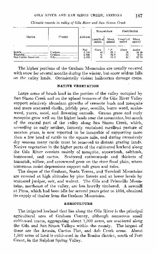
CLIMATE
The climate of the valley of the Gila River and San Simon Creek is mild and dry, as shown by the following table, which is compiled from records of the United States Weather Bureau:
GILA RIVER AND SAN SIMON CREEK, ARIZONA
Climatic records in valley of Gila River and San Simon Creek
Station
Thatcher. ..................
County
Gila... .......... ...-.-
Altitude
Feet 3,756 2,800 2,532
Temperature
Length of record
Years 55 41 41
Mean annual
° F. 63.4 62.6 64.3
Precipitation
Length of record
Years 56 32 41
Mean annual
Inches 14.29 9.01
12.74
The higher portions of the Graham Mountains are usually covered with snow for several months during the winter, but snow seldom falls on the valley lands. Occasionally violent hailstorms damage crops.
NATIVE VEGETATION
Large areas of brush land in the portion of the valley occupied by San Simon Creek and on the upland terraces of the Gila River Valley support relatively abundant growths of creosote bush and mesquite and more scattered cholla, prickly pear, ocotillo, burro weed, snake- weed, yucca, sotol, and flowering annuals. Grama grass and curly mesquite grow well on the higher lands near the mountains, but much of the central part of the valley along San Simon Creek, which, according to early settlers, formerly contained excellent pasture of sacaton grass, is now reported to be incapable of supporting more than a few head of cattle to the square mile, and during excessively dry seasons many cattle must be removed to distant grazing lands. Native vegetation in the higher parts of the cultivated lowland along the Gila River consists mainly of mesquite, squawbush, saltbush, burroweed, and cactus. Scattered cottonwoods and thickets of tamarisk, willow, and arrow weed grow on the river flood plain, where numerous moist depressions support salt grass and tules.
The slopes of the Graham, Santa Teresa, and Turnbull Mountains are covered at high altitudes by pine forests and at lower levels by scattered juniper, oak, and walnut. The Gila and Peloncillo Moun tains, northeast of the valley, are less heavily timbered. A sawmill at Pima, which had been idle for several years prior to 1934, obtained its supply of timber from the Graham Mountains.
AGRICULTURE
The irrigated lowland that lies along the Gila River is the principal agricultural area of Graham County, although numerous small cultivated tracts, aggregating about 1,000 acres, are scattered along the Gila and San Simon Valleys within the county. The largest of these are the Artesia, Cactus Flat, and Ash Creek areas. About 1,500 acres of land is cultivated in the Bonita district, south of Fort Grant, in the Sulphur Spring Valley.

CONTRIBUTIONS TO HYDROLOGY OP UNITED STATES, 1937
The Federal census for 1890 ranked the chief crops of Graham County in order of importance as hay, corn, barley, and wheat. By 1900 wheat held first place, followed by alfalfa, barley, and corn. In 1910 alfalfa was leading and was followed by barley, wheat, and corn. In 1920 the order was alfalfa, wheat, barley, corn, and grain sorghums; cotton had been introduced. In 1930 cotton outranked all other crops, with an acreage nearly twice that of alfalfa.
Almost all agricultural products, other than alfalfa and cotton, are consumed locally. Practically all the cotton produced in recent years has been ginned at Safford and the lint exported to Japan through California ports. Yields of 2 bales to the acre are not uncommon on many of the farms. A large part of the alfalfa crop is sold outside the county.
The soil of the agricultural belt along the Gila River is generally described as "sandy loam" and "silt loam" 7 and is highly fertile.
GEOMORPHOLOGY
In early Quaternary or late Pliocene time a lake that had occupied the valley of the Gila River and San Simon Creek during late Tertiary time found an outlet, probably at the site of the Coolidge Dam, and as the water drained away it exposed to erosion a great mass of sedi ments that had accumulated in the basin, mainly unconsolidated clay, silt, sand, and gravel. The erosion of these sediments has pro duced a variety of land forms.
SAN SIMON VALLEY
The upper part of the valley, in Cochise County, is described by Schwennesen 8 as follows:
The valley has the form of a broad, shallow trough, the sides of which are formed by the alluvial slopes that extend down from the bordering mountains. Where the valley is narrow the bases of the alluvial slopes almost meet at the axis, but where the valley is wide it has the appearance of a nearly level plain with upward-curving edges.
This description is applicable to the wide San Simon Valley at the southern boundary of Graham County. To the north lowering of the Gila River twice during Pleistocene time initiated cycles of erosion, the effects of which have progressed up the San Simon Valley for many miles, altering the form of the valley floor. The old surface of this part of the San Simon Valley, which no doubt resembled that of the upper part of the present valley, as described by Schwennesen, is now preserved in part as gravel-capped terrace remnants that slope gently downward toward the center of the valley from both sides, as shown in plate 47, B.
7 Lapham, M. C., and Neill, N. P., Soil survey ef the Solomonsville area, Ariz.: IT. S. Dept. Agr., Bur. Soils, Field Operations, 1903, pp. 10-20, 1904.
8 Schwennesen, A. T., Ground water in San Simon Valley, Ariz. and N. Mex.: Qeol. Survey Water-Supply Paper 425-A, p. 5, 1917.
GILA RIVER AND SAN SIMON CREEK, ARIZONA
Mormon settlers, who arrived from Utah early in the eighties, found the valley in essentially its present form, but the present trench, known as San Simon Creek, a steep-walled gully in the valley floor (see pi. 48, A, B), did not then exist. According to the statements of many inhabitants, the San Simon Valley lowlands at that time supported a luxuriant growth of grass, which has since vanished. Many investigators believe that these changes, which have occurred since the arrival of white settlers, are to be attributed, at least in part, to the removal of the protective cover of vegetation by excessive grazing followed by increased run-off and greater erosion. Stock trails are said to be the forerunners of small watercourses, which grow to become broad, steep-walled arroyos. A few writers, however, have pointed out that climatic changes or tectonic movements may be capable of producing similar results. A decrease in the mean annual precipitation would kill off part of the vegetation, and if accompanied or followed by storms of increased violence, streams that had been aggrading their beds might begin cutting. An increase in the gradient of streams by slight regional uplift would no doubt have a similar effect.
Bryaii 9 favored the hypothesis of a recent climatic change. Regard ing the approximate time at which the phenomena mentioned began to appear, he says:
The change from aggradation and the building of flood plains to dissection and the formation of arroyos in many streams of southern Arizona can be confidently placed in the decade 1880 to 1890, although many tributary streams were not affected until the nineties, and some are still undissected. The date in southern Utah, northern Arizona, and southern Colorado is apparently earlier, and cutting probably began at some time after 1860.
Gregory,10 in discussing the "recent cycle of erosion" in the Navajo country, states thathuman factors exert a strong influence but are not entirely responsible for the dis astrous erosion of recent years. The region has not been deforested; the present cover of the vegetation affects the run-off but slightly, and parts of the region not utilized for grazing present the same detailed topographic features as the areas annually overrun by Indian herds.
Gregoryj11 has later been inclined to regard recent regional tectonic activity as a possible cause of the trenching, an explanation which Bryan rejected.
Bryan n summarizes information on trenching in the San Simon Valley as follows:
San Simon Creek, which enters the Gila River near Solomonsville, once flowed* through uninterrupted meadows and flats from a point near Rodeo more than
9 Bryan, Kirk, Date of channel trenching (arroyo cutting) in the arid Southwest: Science, new set., vol. 62, pp. 338-344, 1925.
10 Gregory, H. E., Geology of the Navajo country, a reconnaissance of parts of Arizona, New Mexico, and Utah: Geol. Survey Prof. Paper 93, p. 132,1917.
11 Gregory, H. E., oral communication to the writer, 1934. " Bryan, Kirk, op. cit., p. 342.

19Q CONTRIBUTIONS TO HYDROLOGY OF UNITED STATES, 1937
100 miles to its mouth. According to Olmstead, 13 settlers near Solomonsville in 1883 excavated a small channel 20 feet wide and 4 feet deep to confine the flood water. Since that time a channel formed and progressed headward through the flats for 60 miles to the lower end of the San Simon Cienaga. Above this point there is no definite channel, but the new channel of the creek downstream is 10 to 30 feet deep and 600 to 800 feet wide. Schwennesen 14 describes the drainage of the area and states that the channel has formed sir.ce the advent of American settlers. Carpenter and Bransford 15 make the same comment but also say that in large floods the channel is still overflowed.
As stated by Olmstead, the channeling in the San Simon Valley began with the digging of the Solomonsville drainage ditch, and much of the headward cutting is reported by early settlers to have followed the ruts of a former wagon road along the valley bottom between Bowie and Solomonsville. Branch trenches are likewise generally confined to the principal drainage channels, which head in or near the mountains bordering the valley. These channels existed long before the advent of stock, and the areas between them are not gullied excessively, as they supposedly should be if stock trails were important contributory factors. The present vehicular trail east of San Simon Creek between Bowie and Solomonsville (pi. 46) runs for miles near the creek over comparatively smooth surfaces, and the only trenches crossed are in old watercourses heading in or near the Peloncillo Moun tains. Under these circumstances it would be difficult, to say the least, to determine which of the possible causes that have been sug gested is the chief cause of the local phenomena under consideration, and it should be borne in mind that erosion in the ancient lake beds began in late Pliocene or early Pleistocene time. It is conceivable that numerous "epicycles of erosion", similar to that recently begun, may have occurred during each of the major cycles of aggradation and degradation recorded in the valley terraces and described in the fol lowing pages. In this connection, however, it is worthy of note that Bailey,16 having compared the evidence of recent and earlier epicycles in several valleys in Utah, reached the conclusion that "utilization of the region by man and the consequent reduction and modification in the plant cover are major factors in starting the new epicycle of ero sion." It is possible that further studies will confirm this view.
GIL A VALLEY
GENERAL FEATURES
The Gila River, a perennial stream carrying a large volume of water, has cut down into the late Tertiary sediments much more effectively
" Olmstead, F. H., Gila Kiver flood control: 65th Cong., 3d sess., S. Doc. 436,1919.i* Schwennesen, A. T., Ground water in San Simon Valley, Ariz. and N. Mex.: Geol. Survey Water-
Supply Paper 425, pp. 5-6,1917.15 Carpenter, E. J., and Bransford, W. S., Soil survey of the San Simon area, Ariz.: U. S. Dept. Agr., Bur.
Soils, Field Operations, 1921, pp. 584, 594, 1924.is Bailey, E. W., Epicycles of erosion in the valleys of the Colorado Plateau province: Jour. Geology, vol.
43, no. 4, pp. 337-355, 1935.
GILA RIVER AND SAN SIMON CREEK, ARIZONA
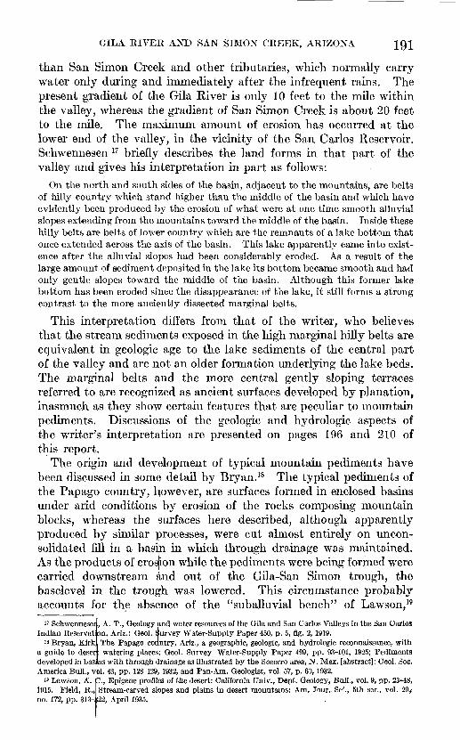
than San Simon Creek and other tributaries, which normally carry water only during and immediately after the infrequent rains. The present gradient of the Gila River is only 10 feet to the mile within the valley, whereas the gradient of San Simon Creek is about 20 feet to the mile. The maximum amount of erosion has occurred at the lower end of the valley, in the vicinity of the San Carlos Reservoir. Schwennesen 17 briefly describes the land forms in that part of the valley and gives his interpretation in part as follows:
On the north and south sides of the basin, adjacent to the mountains, are belts of hilly country which stand higher than the middle of the basin and which have evidently been produced by the erosion of what were at one time smooth alluvial slopes extending from the mountains toward the middle of the basin. Inside these hilly belts are belts of lower country which are the remnants of a lake bottom that once extended across the axis of the basin. This lake apparently came into exist ence after the alluvial slopes had been considerably eroded. As a result of the large amount of sediment deposited in the lake its bottom became smooth and had only gentle slopes toward the middle of the basin. Although this former lake bottom has been eroded since the disappearance of the lake, it still forms a strong contrast to the more anciently dissected marginal belts.
This interpretation differs from that of the writer, who believes that the stream sediments exposed in the high marginal hilly belts are equivalent in geologic age to the lake sediments of the central part of the valley and are not an older formation underlying the lake beds. The marginal belts and the more central gently sloping terraces referred to are recognized as ancient surfaces developed by planation, inasmuch as they show certain features that are peculiar to mountain pediments. Discussions of the geologic and hydrologic aspects of the writer's interpretation are presented on pages 196 and 210 of this report.
The origin and development of typical mountain pediments have been discussed in some detail by Bryan. 18 The typical pediments of the Papago country, however, are surfaces formed in enclosed basins under arid conditions by erosion of the rocks composing mountain blocks, whereas the isurfaces here described, although apparently produced by similar processes, were cut almost entirely on uncon- solidated fill in a basin in which through drainage was maintained. As the products of erosion while the pediments were being formed were carried downstream and out of the Gila-San Simon trough, the baselevel in the trough was lowered. This circumstance probably accounts for the absence of the "suballuvial bench" of Lawson, 19
17 Schwennese:Indian Reservat m, Ariz.: Geol.
is Bryan, Kirka guide to deser, watering places: Geol. Survey Water-Supply Paper 499, pp. 93-101, 1925; Pediments developed in bas as with through cjlrainage as illustrated by the Soeorro area, N. Mex. [abstract]: Geol. Soc.America Bull., v
19 Lawson, A.1915. Field, R.-,no. 172, pp. 313-:
, A. T., Geology ;ind water resources of the Gila and San Carlos Valleys in the San Carlosurvey Water-Supply Paper 450, p. 5, fig. 2,1919.
The Papago country, Ariz., a geographic, geologic, and hydrologic reconnaissance, with
01. 43, pp. 128-129, 1932, and Pan-Am. Geologist, vol. 57, p. 63,1932. )., Epigene profiles of the desert: California Univ., Dept. Geology, Bull., vol. 9, pp. 23-48, Stream-carved slopes and plains in desert mountains: Am. Jour.. Sei., 5th ser., vol. 29,> 22, April 1935.

192 CONTRIBUTIONS TO HYDROLOGY OF UNITED STATES, 1937
a feature characteristically associated with pediments formed while the baselevel is rising as a result of accumulation of detritus in an enclosed basin. The pediments that slope downward from both sides of the upper San Simon Valley flatten out and meet in the central part of the trough as described by Schwennesen. (See p. 188.)
UPPER TERRACE
Along the southwest side of the Gila Valley a dissected gravel- covered terrace (see pi. 49, A, B) is the remnant of an ancient pedi ment and is called in this paper the "upper terrace." This terrace extends southeastward from the San Carlos Indian Reservation and forms a continuous surface with the relatively undissected valley floor in the southern part of the San Simon Valley. At the base of the Graham Mountains southwest of Thatcher the upper limit of this terrace is several hundred feet higher than elsewhere along the margin of the valley. The highest point on the terrace is at the mouth, of Frye Canyon and is about 5,200 feet above sea level. The longitudinal section of the upper terrace close to the mountains in this neighborhood is convex upward, suggesting a typical alluvial fan formed by aggradation at the mouth of Frye Canyon. However, a belt of fanglomeratic Gila conglomerate lies along the base of the Graham Mountains in this vicinity, and the contact between the Gila fanglomeratic phase and the similar overlying gravel that spreads out basinward as a thin coating over the lake beds of Gila age could not be located at the time of examination. It is possible that a detailed study of the prominent fan at the mouth of Frye Canyon would show it to belong to the degradational "rock fan" type, as originally described by Paige 20 and elaborated later by Johnson.21
At the mouth of Tripp Canyon the altitude of the upper terrace is about 4,400 feet above sea level; near the Swift Trail the highest point on it is at an altitude of about 4,100 feet; and at the Fort Grant road about 7 miles south of Artesia the altitude is about 4,300 feet. Schwennesen's diagrams show the edge of the valley deposits at the base of the Turnbull Mountains to be about 4,000 feet above sea level.
Nearer the central axis of the Gila Valley the upper terrace is pre served on numerous isolated mesas that have been carved by the streams in the clay, silt, and sandy layers characteristic of the late Pliocene lake beds of the central part of the basin. Each mesa is capped by a layer of Pleistocene (?) gravel, usually from 6 to 10 feet thick, firmly cemented by calcium carbonate (caliche) to form a con glomerate whose pebbles are fairly well rounded and are in general
80 Paige, Sidney, Rock-cut surfaces in the desert ranges: Jour. Geology, vol. 20, pp. 442-450, 1912.11 Johnson, D. W., Planes of lateral corrasion: Science, new ser., vol. 75, pp. 174-177, 1931; Rock fans of
arid regions: Am. Jour. Sci., 5th ser., vol. 23, pp. 389-416,1932; Rock planes of arid regions: Qeog. Review, vol. 22, pp. 656-665, 1932.

GEOLOGICAL SURVEY WATER-SUPPLY PAPER 796 PLATE 47
A. VIEW LOOKING NORTH OVER IRRIGATED LOWLANDS ALONG THE GILA RIVER NEAR SOLOMONSVILLE.
B. VIEW LOOKING NORTHWEST DOWN SAN SIMON VALLEY FROM A POINT NEAR TANQUE.
San Simon Creek in the foreground.

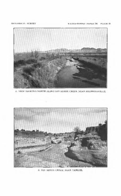
GEOLOGICAL SURVEY WATER-SUPPLY PAPER 796 PLATE 48
A. VIEW LOOKING NORTH ALONG SAN SIMON CREEK NEAR SOLOMONSVILLE.
B. SAN SIMON CREEK NEAR TANQUE.


GEOLOGICAL SURVEY WATER-SUPPLY PAPER 796 PLATE 49
A. REMNANTS OF UPPER TERRACE ON FLANK OF GRAHAM MOUNTAINS.
B. VIEW LOOKING SOUTH TOWARD GRAHAM MOUNTAINS FROM POINT NEAR THATCHER.
Upper terrace is seen at base of mountains.


GEOLOGICAL SURVEY WATER-SUPPLY PAPER 796 PLATE 50
A. LAKE BEDS EXPOSED AT RED KNOLLS "DESERT THEATER", IN VALLEY IJi MILESSOUTHWEST OF ASHURST.
Two conspicuous hard layers near top are limestone containing fresh-water invertebrate fossils.
B. GILA CONGLOMERATE ON BIG SPRING WASH, NEAR CENTER OF T. 5 S., R. 25 E.
About 50 feet of conglomerate is exposed.


GILA RIVER AND SAN SIMON CREEK, ARIZONA
composed of the same materials as the fanglomeratic phase of the Gila conglomerate. The gravel is everywhere coarse, and the pebbles are poorly assorted in size. In sec. 27, T. 7 S., R. 25 E., 4 miles from the base of the Graham Mountains, boulders 2 feet in diameter occur in the conglomerate that caps a small mesa. The steep gradient, gen erally more than 30°, of the sloping escarpment of this terrace is due to the resistance to erosion that is offered by the hard capping layer of caliche and the ease of erosion in the underlying unconsolidated lake beds.
On the opposite side of the valley no terrace corresponding to this one seems to be present, unless it is indicated by a few caliche-capped mesas in sec. 31, T. 5 S., R. 25 E., the tops of which are about 3,330 feet above sea level, or about 100 feet above the surrounding upland. Possibly the upper terrace was formerly matched by a terrace sloping away from the Gila Mountains northeast of the present river and higher than the present surface there. At that time the Gila Valley was probably a broad trough resembling the present San Simon Valley in the neighborhood of San Simon, as described by Schwennesen.
LOWER TERRACE
A second dissected pediment surface, which may be called the "lower terrace", is bounded on the southwest side of the valley by the upper terrace and slopes gently downward toward the alluvial lowlands of the Gila Valley (pi. 49, 7?). Northeast of the Gila River it is matched by a similar terrace that rises to the base of the Gila Mountains. These two surfaces represent a second major episode in the erosional history of the valley since the lake disappeared, involving cutting by the Gila River down to a level about 100 feet above its present channel, at which it remained long enough to permit its tribu taries to cut away large parts of the erosion surface represented by the upper terrace. Like the upper terrace, the lower terrace on each side of the valley is covered by a thin layer of coarse gravel cemented by calcium carbonate, and here also the cutting of the soft lake beds below the hard caliche capping has produced steeply sloping escarp ments along the terrace faces. At this stage cutting extended up the San Simon Valley for more than 15 miles above Solomonsville.
ALLUVIAL PLAINS
The alluvial lowland plain along the Gila River (pi. 47, A] extends from the San Carlos Reservoir upstream and terminates at the nar rows about 2 miles above Sanchez. This plain, which was built by the Gila River, is bordered on both sides by the steeply sloping escarp ments at the foot of the lower terrace; its width is about 1 mile at Geronimo and Fort Thomas, about 2% miles at Pima, 3 miles at Thatcher and Safford, 2 miles at Solomonsville, and \% miles at San
149555 38 2

194 CONTRIBUTIONS TO HYDROLOGY OF UNITED STATES, 1937
Jose and Sanchez. The history of its origin may be briefly outlined as follows:
After the long pause during which the erosion surface represented by the lower terrace was formed, the Gila River excavated a trench about 200 feet deep in the Pliocene lake beds. A further halt in the downward cutting of the river was attended by lateral cutting and aggradation, which have continued until comparatively recent time. These processes have built up the present broad bottom land, floored by alluvial deposits, in places 100 feet thick and consisting largely of unconsolidated gravel, sand, and silt.
During recent years the Gila River has been cutting into the allu vium, and the present flood plain upon which the river meanders is in most places less than half a mile wide. Those areas in the alluvial belt that are never flooded by the river constitute the principal agricultural lands of Graham County. Smaller tracts along the tributaries of the Gila River are also underlain by alluvium belonging to the latest stages of erosion and deposition, and these lands are farmed at Artesia, Cactus Flat, Ash Creek, and Cottonwood Creek.
Trenching similar to that in the San Simon Valley has taken place along nearly all the tributaries of the Gila River, and this river itself has cut away several thousand acres of cultivated land. The possi bility of controlling floods in the valley was studied by Olmstead.22 During the winter of 1933-34 the United States Soil Erosion Service constructed many small dams along creeks in the area southwest of Thatcher in an effort to prevent further encroachment on farming and grazing lands by streams heading in the Graham Mountains and to replace by fresh deposits of silt the cultivable land that has beenwashed away.
GEOLOGY
STRUCTURE
The Gila-San Simon trough and the other valleys that lie roughly parallel to it in the Mexican Highland section of the Basin and Range province in southeastern Arizona are underlain by thick detrital deposits of late Tertiary and Quaternary age. The hypothesis, pro posed by Gilbert,23 that such valleys and the mountains between which they lie originated by block faulting has, in its broad outlines, found most favor among geologists, though their origin through dif ferential erosion of hard and soft rocks under arid conditions in a region of folding, accompanied by some faulting, has been broached from time to time.
The exposed alluvial and lacustrine fill, of Pliocene and Pleistocene age, in the Gila and San Simon Valleys shows little evidence of having
« Olmstead, F. H., Qila River flood control: 65th Cong., 3d sess., S. Doc. 436, 1919." Gilbert, Q. K., U. S. Geog. and Geol. Surveys W. 100th Mer. Kept., vol. 3, Geology, pp. 21-42,1875. ,

GILA RIVER AND SAN SIMON CREEK, ARIZONA
been disturbed since it was deposited. Over large areas the beds of the Gila conglomerate, of Pliocene age, appear to lie nearly horizontal, though at a number of localities they are gently tilted or warped. This is true of most of the deposits in Arizona and New Mexico that have been described as Gila conglomerate, though in the Ray quad rangle Ransome 2* tentatively assigned to that formation steeply tilted beds which at first he had believed to underlie the Gila unconformably. In the Aravaipa Valley, according to Ross,25 the relatively undis turbed Gila conglomerate rests unconformably on steeply upturned Miocene (?) beds of lava and tuff interbedded with conglomerate and sandstone. These beds may be equivalent to the Miocene (?) beds of the Santa Cruz Valley near Tucsoii, which are also greatly de formed, and to the Whitetail conglomerate 26 of the Ray and Globe quadrangles. It is inferred from these data that most of the deforma tion of mountain-building proportions affected this region prior to the late Miocene or early Pliocene deposition of the Gila conglomerate. It was possibly as a result of the deformation that water became ponded in several valleys during the late Pliocene to form lakes of the type described in this paper.
METAMOBPHIC AND IGNEOUS BOCKS
The Graham Mountains and, according to Ross,27 the cores of the Santa Teresa and Turnbull Mountains are composed mainly of pre- Cambrian Pinal schist and associated igneous rocks. Cambrian quartz- ite, early Tertiary quartz monzonite, and middle or late Tertiary volcanic rocks crop out on the northeast side of these mountain ranges but are there commonly overlapped and concealed by the Gila con glomerate of the valley of the Gila River and San Simon Creek.
The Peloncillo and Gila Mountains,28 which border the basin on the northeast, are made up mainly of intrusive and extrusive igneous rocks, a large part of which are probably of Tertiary age, although some of the lavas may be Quaternary.
24 Ransome, F. L., The copper deposits of Ray and Miami, Ariz.: Geol. Survey Prof. Paper 115, pp. 71-74, 1919.
25 Ross, O. P., Geology and ore deposits of the Aravaipa and Stanley mining districts, Graham County, Ariz.: Geol. Survey Bull. 763, pp. 29-31, 1925.
26 Ransome, F. L., op. cit., pp. 67-68.2' Ross, O. P., op. cit., p. 13.28 Darton, N. H., A resume of Arizona geology: Arizona Univ. Bull. 119, p. 263,1925.
19(3 CONTRIBUTIONS TO HYDROLOGY OF UNITED STATES, 1937
SEDIMENTARY BOCKS
GILA CONGLOMERATE
GENERAL FEATURES
Sedimentary deposits of lake and stream origin fill the valley of the Gila Kiver and San Simon Creek to a depth of possibly 1,600 feet. The area occupied by these valley deposits in Graham County ranges from 10 to 20 miles in width, and they extend more than 100 miles up the valley from the Coolidge Dam. In the central part of the valley they are of lacustrine origin and are characteristically fine-grained, consisting of stratified red and gray clays and silts, with here and there layers of tuff and marly limestone. (See pis. 50, A; 51, A, B.) These prevailingly fine-grained materials grade laterally into fanglomerate (pi. 50, B}, which is included in the Gila conglomerate as originally defined by Gilbert 29 and which extends in belts along the sides of the valley. This coarse material is of fluviatile origin and was no doubt deposited as alluvial fans and deltas by streams issuing from the moun tains along the shores of the ancient lake. The pebbles and boulders of this lateral or shore phase of the formation are largest at the base of the mountains, where they are commonly a foot or more in diameter. On the southwest side of the valley they are composed chiefly of schist and coarse-grained igneous rocks derived from the Graham, Santa Teresa, and Turnbull Mountains. On the northeast side of the valley the pebbles are predominantly fragments of volcanic rock transported from the Gila Mountains. The belts of fanglomerate exposures are several miles wide in some places, but are absent in others. A broad belt skirts the Gila Mountains from the San Carlos Indian Reservation southeastward nearly to Sanchez, being interrupted only in the vicinity of Fort Thomas. A second broad belt skirts the Santa Teresa Moun tains and extends a few miles southeast of the Fort Grant road. For several miles northwest and southeast of Frye Creek the belt of fan- glomerate is not more than a mile wide. Belts in the upper San Simon Valley and in the lower Gila Valley are described by Schwennesen.30 The f anglomeratic phase is absent along the base of the Whitlock Hills and in the vicinity of the 111 ranch, where the lake beds are composed of gray clays and beds of white diatomite and chert, shown in plate 52, A
In the absence of detailed surveys no accurate estimate of the exposed thickness of lake beds in the valley is possible. It is probably not more than 200 feet, but the strata penetrated in at least the upper 1,600 feet in deep wells drilled at Safford, Pima, and Ashurst are apparently of lacustrine origin. The logs of the deep wells (pp. 202-204) show no large body of conglomerate older than the lake beds
" Gilbert, G. K., op. cit., pp. 540-541.30 Schwennesen, A. T., Ground water in San Simon Valley, Ariz. and N. Mex.: Geol. Survey Water-
Supply Paper 425, p. 8, 1917; Geology and water resources of the Gila and San Carlos Valleys in the San Carlos Indian Reservation, Ariz.: Geol. Survey Water-Supply Paper 450, pp. 7-9, 1919.

GILA RIVER AND SAN SIMON CREEK, ARIZONA
and underlying them at a depth of about 600 feet below the surface, as postulated by Schwennesen,31 whose diagram, moreover, shows the "high marginal hilly belts" in the San Carlos Indian Reservation to be underlain exclusively by alluvial material. The writer found that the dissected upper surface of the high marginal belt or pediment (see p. 191) on the southwest side of the Gila Valley, along the base of the Graham Mountains, is underlain in part by lake beds, in part by fanglomerate, and, in an area of a few square miles, by the crystalline rocks of the Graham Mountains. Schwennesen's concept, in which the limits of the "belts of lower country" in the San Carlos Reserva tion are regarded as coincident with the outlines of the former lake, is thus contradicted, so far as the extension of the Gila Valley southeastward into Graham County is concerned. Furthermore, the transition from coarse detrital material in the basin deposits, as exposed along several arroyos near the margins of the valley, to predominantly fine-grained material in the central part of the trough occurs not abruptly but gradually. Interfingering of the two types of fill, as shown in figure 30, is inferred from well data and is supported by the hydrologic considerations set forth on pages 209-211. Such relations would scarcely be expected to exist if the fanglomerates and lake beds were deposited at separate times. The Gila conglomerate as a geologic formation must therefore include both lake beds and fanglomerates, the two phases having originated simultaneously. The late Pliocene age of the lacustrine phase of the Gila conglomerate in this area is known from fossil evidence obtained during the present investigation and set forth below. As the lacustrine deposits have been traced continuously to the mouth of Bonita Creek (see pi. 45), they may safely be regarded as lying within the type locality of the Gila conglomerate as given in the following quotation from Gilbert's original definition of that formation,32 where the Gila and San Simon Valleys are referred to as the "Pueblo Viejo Desert."
Beginning at the mouth of the Bonita, below which point their distinctive characters are lost, they follow the Gila for more than 100 miles toward its source, being last seen a little above the mouth of the Gilita. * * * Below the Bonita it [the Gila conglomerate] merges insensibly with the detritus of Pueblo Viejo Desert.
The character of the late Pliocene deposits in this valley is evidently very much the same as in the San Pedro Valley, to the southwest, which is described by Bryan 33 as follows:
The conglomerate (fanglomerate) of the typical facies encircles unconsolidated fine-grained deposits laid down in the central areas of the original valleys. In
31 Schwennesen, A. T., Geology and water resources of the Gila and San Carlos Valleys in the San Carlos Indian Reservation. Ariz.: Geol. Survey Water-Supply Paper 450, pp. 7-10, 1919.
32 Gilbert, G. K., op. cit., pp. 540-541, 1875.33 Bryan, Kirk, San Pedro Valley, Ariz., and the geographic cycle [abstract]: Geol. Soc. America Bull.,
vol. 37, p. 169, 1926.

198 CONTRIBUTIONS TO HYDROLOGY OF UNITED STATES, 1937
the fine-grained deposits a large vertebrate fauna, determined by Gidley to be of late Pliocene age, has been found.
FOSSILS
Vertebrate fossils that were collected by the writer from the lake beds of the valley of the Gila River and San Simon Creek at two localities about 25 miles apart (111 ranch and Henry ranch) include camel bones, peccary teeth, a sloth bone, teeth and bones belonging to three genera of horses, and fragments of a large turtle. These, together with photographs and casts of part of a mastodon skull from a third locality, near Bear Springs, were referred for determination to C. L. Gazin, of the United States National Museum, whose preliminary report follows:
1. Nannippus locality, 111 ranch, sec. 27, T. 8 S., R. 28 E.:
Hipparion (Nannippus) sp. (teeth and jaw fragments). Equid, large form (tooth fragments and foot bones). Camelid sp. (fragments of limb and foot bones). Platygonus sp. (teeth). Megalonychid sp. (ungual phalanx).
2. Plesippus locality, Henry ranch, NE^ sec. 22, T. 5 S., R. 23 E.:
Plesippus sp. (teeth and bone fragments). Camelid sp. (fragmentary foot bones).
3. Mastodon locality, Bear Springs, SEJ£ sec. 9, T. 7 S., R. 23 E.:
Rhynchotherium? sp. (portion of skull with teeth, identified from photographs and casts of the tooth crowns).
There is probably little or no difference in the age of the above three occurrences, as the presence of Nannippus, Plesippus, and a mastodon resembling Rhyncho therium in each locality indicates an upper Pliocene age. The part of the upper Pliocene represented is not clearly indicated, although the part represented appears to be less advanced than the Plesippus zone at Hagerman, Idaho,34 and probably not greatly separated in time from the Blanco of Texas. 35 As compared with the horizons that carry mammalian remains in the San Pedro Valley of Arizona,36 the horizons in the Gila and San Simon Valleys appear to be older than the late Pliocene or Pleistocene at the Curtis ranch, about 15 miles south of Ben- son, Ariz., and younger than or possibly equivalent to the upper Pliocene recog nized near Benson.
The turtle remains were submitted to C. W. Gilmore for identification, and he reported them as undeterminable testudinate remains that gave no indication as to age.
34 Gidley, J. W., A new Pliocene horse from Idaho: Jour. Mammalogy, vol. 11, pp. 300-303, 1930; Con tinuation of the fossil-horse round-up on the old Oregon Trail: Smithsonian Inst. Explorations and Field Work in 1930, pp. 33-40, 1931. Boss, N. H., Explorations for fossil horses in Idaho: Smithsonian Inst. Explorations and Field Work in 1931, pp. 41-44, 1932.
35 Gidley, J. W., The fresh-water Tertiary of northwestern Texas: Am. Mus. Nat. History Bull., vol. 19, pp. 617-635,1903. Cope, E. D., A preliminary report on the vertebrate paleontology of the Llano Estacado; Texas Geol. Survey 4th Ann. Kept., pt. 2, pp. 47-74, 1893. Plummer, F. B., Cenozoic systems in Texas: Texas Univ. Bull. 3232, vol. 1, pp. 765-776, 1932.
36 Gidley, J. W., Preliminary report on fossil vertebrates of the San Pedro Valley, Ariz., with descriptions of new species of Eodentia and Lagomorpha: U. S. Geol. Survey Prof. Paper 131, pp. 119-131, 1922; Fossil Proboscidea and Edentata of the San Pedro Valley, Ariz.: U. S. Geol. Survey Prof. Paper 140, pp. 83-95, 1926.
GILA RIVER AND SAN SIMON CREEK, ARIZONA ^99
Fossil invertebrates from a fourth locality, in the lake beds near Red Knolls, were studied by W. C. Mansfield, of the Geological Survey, who states:
4. Planorbis locality, Red Knolls, sec. 36, T. 5 S., R. 22 E. From a limestone about 40 feet higher than unidentified vertebrate bones:
Lymnaea? sp. (only a fragment of a spire seen).Planorbis (species indeterminable; specimens badly crushed).
The fauna lived under fresh-water conditions. The age is indeterminable because of the poor state of preservation of the organisms; however, they do not look very old.
Fossil wood from locality 2 (Plesippus locality) has been studied by R. W. Brown, of the Geological Survey, who writes:
Among several specimens of silicified wood from sec. 22, T. 5 S., R. 23 E., Graham County, Ariz., only one was well enough preserved to show identifiable cellular elements. A transverse section of this wood exhibits distinct annual rings composed of about equal zones of spring and summer wood. The vessels of the spring wood are large and uniform; those of the summer wood, minute. The transition from the open spring wood to the dense summer wood is conspicuously abrupt. The medullary rays are narrow, barely visible to the naked eye, and lie between single, rarely double, rows of vessels. The radial and tangential sections reveal nothing definitive. This wood is clearly a ring-porous, dicotyledonous species, resembling in some respects the living Sassafras variifolium. I should hesitate, however, to identify it positively as a Sassafras. Its well-defined annual rings suggest regular seasonal changes, either wet to dry or warm to cold, or both. As to its geologic age I can offer only a guess that it may have lived in the middle or late Tertiary.
Diatomite collected by the writer from two localities was examined by K. E. Lohman, of the Geological Survey, whose report follows:
Geol. Survey diatomite locality 2054, 111 ranch, Ariz., SE}4 sec. 21, T. 8 S., R. 28 E.
This material consists chiefly of volcanic ash and some clastic material, diatoms constituting only about 30 percent of the total. It is useless for any purpose for which diatomite would be required. The following species of diatoms are present (C, common; F, frequent; R, rare):
Melosira italica (Ehrenberg) Kiitzing. F. Podosira sp. R.Stauroneis cf. S. phoenicenteron Ehrenberg. F. Anomoeoneis sphaerophora (Kiitzing) Pfitzer. F. Navicula cf. N. cuspidata Kiitzing. R. Navicula amphibola Cleve. F. Pinnularia major (Ktitzing) Cleve. C. Pinnularia microstauron (Ehrenberg) Cleve. F.
i Gomphonema longiceps Ehrenberg var. subclavata Grunow. R. Denticula elegans Kiitzing. C.Epithemia zebra (Ehrenberg) Kiitzing var. procellus (Kiitzing) Grunow. R. Rhopalodia gibberula (Ehrenberg) Miiller. F. Nitzschia sp. R. Campylodiscus clypeus Ehrenberg. R.
Geol. Survey diatomite locality 2055, opposite Fort Thomas, Ariz., SWA sec. 24. T. 4 S., R. 23 E.

200 CONTRIBUTIONS TO HYDROLOGY OF UNITED STATES, 1937
This material is an impure diatomite, the impurities, chiefly silt, amounting to approximately 15 percent. It would be suitable for such purposes as heat and sound insulation but would not be marketable in competition with even medium grades of diatomite from California, Oregon, Nevada, and other areas, because of impurities. Its economic use would depend on a local market. Heat insulation is suggested as the most likely purpose for which it might be used.
The following species of diatoms are present (A, abundant; C, common; F, frequent):
Cyclotella meneghiniana Kiitzing. C. Mastogloia cf. M. smithii Thwaites. F. Gomphonema cf. G. lanceolatum Ehrenberg. F. Denticula elegans Kiitzing. A. Surirella striatula Turpin. F. Campylodiscus clypeus Ehrenberg. F.
The diatoms in both these samples suggest that they were deposited in warm, somewhat saline lake water. All the species are living at the present time, so that no evidence of age is offered, other than that the deposits can hardly be very old. All these species have been found in rocks of supposed Pliocene age, so that these deposits may be of Pliocene age or younger.
PLEISTOCENE (?) TERRACE GRAVEL
The middle and upper terraces of the valley of the Gila River and San Simon Creek are capped by caliche-cemented coarse gravel, the nature, origin, and stratigraphic relations of which are described on pages 190-193 of this report. As no fossils have been found in the gravel, its geologic age can only be inferred. Both the gravel capping the upper terrace and that capping the lower terrace, which is of later origin, are tentatively assigned to the Pleistocene because they rest unconformably on the upper Pliocene lake beds and were formed before the deposition of the alluvium that underlies the lowland plain along the Gila River.
QUATERNARY ALLUVIUM
Alluvium, consisting of silt, sand, and gravel, underlies the lowland plain along the Gila River and less extensive areas along the tributaries of the river in Graham County. Deposition of this material probably began in Pleistocene time and has been in progress on the flood plain of the river until recently. The areal distribution of the alluvium, the history of its origin, its physiographic relations, and its economic value are briefly described on pages 187, 188, 193, 194, and 207.
The thickness of alluvium underlying the lowland plain differs from place to place but is probably nowhere much more than 100 feet. A general idea of the character of the alluvium as shown by wells may be obtained from the following sections:

GEOLOGICAL SURVEY WATER-SUPPLY PAPER 796 PLATE 51
A. BADLANDS DEVELOPED IN FOSSILIFEROUS LAKE BEDS ABOUT 2 MILES WEST OF BEAR SPRINGS, T. 7 S., R. 23 E.
Santa Teresa and Turnbull Mountains in the distance; conspicuous terrace is a gravel-capped erosion surface.
B. FOSSILIFEROUS LAKE BEDS NEAR 111 RANCH, IN SEC. 27 ,T. 8 S., R. 28 E


GEOLOGICAL SURVEY WATER-SUPPLY PAPER 796 PLATE 52
A. DIATOMITE WITH THIN CHERT LAYERS IN LAKE BEDS 1 MILE EAST OF 111 RANCH.
B. CIENAGA SPRINGS, IN JACOBSON WASH, EAST OF CACTUS FLAT.


GILA RIVER AND SAN SIMON CREEK, ARIZONA 201
Generalized section of alluvium from Solomonsville eastward
Soil _ ._._ _.
Unconformity ___ -----._--.----...
Hard black shaly clay with sand lenses.
Thick ness
Feet 5
35
1050+
Depth
Feet 5
40
50100 4-
Remarks
alluvium.
Contains good water.
Approximate section from San Simon Creek to Safford
Soil .
Thick ness
Feet 181844
20
Depth
Feet IS3680
100
Remarks
Waler.
alluvium.
Log of E. G. Rogers well, NE}i sec. 5, T. 6 S., R. 24 E.
Sand -. __ _ ._ _ __ .. ....
Sand--.-- . .................
Clay, with beds of limestone and tuff.
Thick ness
Feet 1520
55
102
18
718
Depth
Feet 1535404550606280
800
Remarks
Do.
Do.
alluvium. No sand or gravel and no water.
6 feet thick at about 580 feet.Clean salt
Log of E. W. Black well, NE}iNE}i sec. 19, T. 4 S., R. 23 E.
Sand................................
Clay......"..........................
Unconformity...... -.--...- __ -..
Clay. . __.. _
Thick ness
Feet 27
3 24
b 13 25
5
20+
Depth
Feet 27 30 54 62 75
100 105
125+
Remarks
Water.
Much water, but sand is troublesome. Small amount of water.
Large supply of good water. Contact between lake beds and overlying
alluvium. Lake beds.

202 CONTRIBUTIONS TO HYDROLOGY OF UNITED STATES, 1937
DEEP-WELL RECORDS
The following drillers' logs of four deep wells in the Gila Valley are given with no attempt to show the geologic age of the rocks pene trated. It is believed, however, that all the materials are of sedi mentary origin, and it is possible that at least the upper 1,500 or 1,600 feet of the strata underlying the Quaternary alluvium belong to the lake beds.
Log of Southern Pacific Co.'s well at Tanque, Ariz.
[Pumping yield, 29,000 gallons in 24 hours]
Hardpan _. ... ....... . ... .
Unconformity _ _. . . ___ __ ..
Gravel _ ._ . __ ..
Thick ness
Feet 32 6
52 34
8 12 96
14 6
24 4
34 4
70 4
192 143 30
Depth
Feet 32 38
90 124
132 144 240
254 260 284 288 322 326 396 400 592 735 765
Remarks
Base of alluvium.
High water, 111 feet. Water level while pumping, 115 feet.
Water. Working barrel raised to 155 feet from ground
surface, November 1911.
Bottom of casing. Bottom of well.
Log of Southern Pacific Co.'s well (dry) 17 feet south of center of main track, 124 feet east of center line of Central Avenue, Safford, Ariz.
[Drilled January 1906-March 1907. All water encountered was salty]
Soil..................... .........
Unconformity .. .. _. ....
Yellow clay. . .Blue clay. _ _ ___ _ .
Yellow clay with streaks of gypsum. Yellow clay with strata of hard
rock. Yellow and brown clay with streaks
of gypsum.
Thick ness
Feet 8
82
7040
100
95 105
Depth
Feet 8
90
190260300700800
895 1,000
Remarks
GILA RIVER AND SAN SIMON CREEK, ARIZONA
Log of Mary S. Mack well in sec. 13, T. 6 S., R. 24 E., near Pima
203
Sand .___
Blue shale.. _... . . __ ____- ..Hard shale __ ..-. .... _ __ _ __
Blue shale- . _ . __ . ... _Brown shale- . --------- _ __ ..
Limy shale--- ----- .-..-_Red shale _ .... __ ------ - _ - -Sand -..__ -... ____-_-.__-_Gravel __ __ . . . - - .. .Red shale _ _ --------- ___Red sandstone _ -------- _-_-..Red shale-Red sand-.. ------ ----- - -__
Sandy shale _ - - - ... -. _.
Red shale . .. .. , _.....Red gravel _ ._ _ . . .. ._.Redsand.---. .... __ .. _ _ ...
Gravel ..... _ . ..,_.. ....Hard red sand _ ..... _ .... ...Limy shale.- ... ...._. . -------Redsand- ... . . . _ . . . .Sand; water.-.--.. ... ... - .. .Redsand..- .... ... - ... . .Red shale.- ..Sand; water.. __ . . ... .. ....Redsand.--.. _ .... _ _ .. .. .
Gravel. .... .... .Limy shale.- ------- . . . .. ....
Red shale.- _ ...... . ..... __Broken sand-- .... . ... .. .. ...Hard lime. ... ........ . .. ..
Red shale _ __ ._ .. ..... ....Pink shale .. _ .. . ._... ......
Red shale _ ------- .. __ .....Hard lime,-- ..... . . ......_.Sand ___ . ------ --_-- - -_ -
Gray lime. ....... ... - ... ... .Gray sand. _. ... ___ _ .... ....
Sandy lime . .... ... .... _ ...
Redsand.-.- _ ...... __ . ... ___
Red sandstone ..... ..... -----
Thick ness
Feet 3
17160
120160401050962856951718801060
2503090
258
11952203845
75
4015
1050
1250
5191
30
138176
18
853012
563304010
15589
3970
235
344
1514
24310
180144
29
Depth
Feet 3
20180
3004fiO500510560656684740835852870950960
1,0201,2701,3001,3901,3921,4501,4511,4701,5221,5421,5801,6251,6301,6451,7201,7301,7481,7881,8031,8201,8301,8801, 8851,8971,9471,9522,1432,2202.2502,3052,3182,3992,4752,4802,4982,5202,5752.6602,6902,7022,7072,7702,8002,8402.8503,0053,0943,1013,1403,2103.2123,2473.2503,2543,2583,2733.2873,5303, 540
3,7203.7343.7383,767
Remarks
Base of alluvium; hole full of freshwater.
Well flowing 12,280 barrels of water in 24 hours
Flow of water increased.
Do.
Do.
Flow of water increased to 50,000 barrels in 2-hours.
Hole caving very badly.
Bottom of well. Shut down Nov. 4, 1929Pnlled CM-inch casing and reamed hole to 1 inches to 3,300 feet and drilled 854-inch hole t( depth of 3,767 feet.
204 CONTRIBUTIONS TO HYDROLOGY OF UNITED STATES, 1937
Log of Gila Oil Syndicate's well in the SWl/iNE% sec. 30, T. 5 S., R. 24 E., nearAshurst
Clay. ... ._._.-.
Limy shale. --_. .Gray sand . _
Gravel _-.-..
Brown shale . _ __.
Blue shale- .. _
Brown shale
Brown shale,,-. _ ...
Red shale .. __ .... . -
Sandy limestone _ .....
Thick ness
Feet 50
Qcn
3080505530
8020151535352080604080
480
7010
1257015
11080803050
Depth
Feet 50
430
590620700
805835
1,1351,150
1,2001,2351,255
1,4351,515
9 QQ5
2,0852,210
2,4052,4852, 5652,595
Remarks
Water.
The following section of the flowing well at Geronimo, in sec. 19, T. 4 S., R. 23 E., drilled for oil with cable tools in 1918-19, is furnished from memory by the owner, R. S. Knowles:
Log of flounng well at Geronimo
Clav
QraveL.-- ... .... . .. . ....
Thick ness
Feet
1743
9
40530
27015
Depth
Feet 28458890
495525795810
Remarks
495 feet.
cemented off.
struck below
SUMMARY OF TERTIARY AND QUATERNARY HISTORY
The Tertiary and Quaternary history of the Gila-San Simon trough may be summarized as follows:
An enclosed basin, surrounded by mountains and occupied by a lake, was formed during late Tertiary time, possibly by block faulting. Lacustrine and fluviatile sediments were laid down in the basin to a thickness believed to be 1,600 feet or more. A part at least, if not all, of these beds were laid down in late Pliocene time. The presence of
GILA RIVER AND SAN SIMON CREEK, ARIZONA 205
active volcanoes in the neighborhood during the existence of the lake is proved by the layers of tuff that occur in the lake beds, and possibly part of the great succession of lava flows exposed in the Gila Mountains was extruded during that time. The lake was then drained, exposing the lacustrine and fluviatile sediments to erosion. Gravel-capped piedmont erosion surfaces, of the pediment type, cut in these upper Pliocene beds, were formed, probably in Pleistocene time, on both sides of the valley. At the end of this stage, which is now represented by the upper terrace, the Gila River was several hundred feet above its present level. The Gila later cut down a few hundred feet and then paused while new erosion surfaces, now represented by the lower terrace, were developed on both sides of the valley. The river next excavated a trench about 200 feet below the lower terrace and widened the trench by lateral cutting. The river channel then rose gradually by aggradation, depositing silt, sand, and gravel to form the alluvial lowland plain. It has recently cut down through the alluvium and has deposited the sand, silt, and gravel of its present flood plain.
WATER RESOURCES
SUMMARY
The water available for use in the valley of the Gila River and San Simon Creek may be classified as shown below, according to its mode of occurrence and development for use:
Ground water: Springs. Wells:
Flowing wells. Nonflowing artesian wells. Nonartesian wells.
Water flowing perennially in the Gila River. Water of intermittent streams tributary to the Gila.
The water is used principally for domestic supplies, for watering stock, and for irrigation. Individual wells and springs differ in the amount and temperature of the water they yield, in the amount and chemical character of minerals in solution, and in the depth of the sand and gravel from which the water is obtained. Shallow wells are generally dug by hand. Wells more than 40 feet deep are usually drilled by power-driven machinery. The water of nonflowing wells is pumped to the surface by windmills, by gasoline engines, or by hand or is brought up in buckets attached to ropes. The water of springs, flowing wells, and intermittent streams is commonly stored in reservoirs for use as needed.
206 CONTRIBUTIONS TO HYDROLOGY OF UNITED STATES, 1937
MUNICIPAL WATER SUPPLIES
The municipal water-supply system of Safford and Thatcher is owned and operated by the Arizona Edison Co. The water is ob tained from Frye Creek, which is fed in part by springs and rain but chiefly by melting snow in the Graham Mountains. The company's plant consists essentially of several miles of pipe and two storage reservoirs on Frye Creek. The upper reservoir, at the mouth of Frye Canyon, in sec. 7, T. 8 S., R. 25 E., has a capacity of 70,000,000 gallons. The dam, of variable-radius arch design, is 91 feet high and is constructed of reinforced concrete. The lower reservoir, 3)£ miles downstream, in sec. 34, T. 7 S., R. 25 E., has a capacity of 5,000,000 gallons. When this supply fails, as occasionally happens during periods of drought, water is pumped from a well in the NE%SE% sec. 13, T. 7 S., R. 25 E., on the outskirts of Safford.
The water supplied to the residents of Pima is piped from several flowing wells that, lie along Cottonwood Creek in sec. 8, T. 7 S., R. 24 E. The water is stored in a small concrete reservoir in sec. 25, T. 6 S., R. 24 E. The plant is owned and operated by the City Utility Co. of Pima.
The water supply at Eden is partly obtained from a community- owned spring (see p. 214) and a small concrete reservoir about a mile northeast of the settlement.
All other settlements in the valley, including Solomonsville, Fort Thomas, and Geronimo, are supplied with water from local pumped wells, most of which are owned by individuals.
SURFACE-WATER IRRIGATION
The cultivated lands along the Gila River (pi. 47, J3) are irrigated with water diverted from the river into ditches through which it is conducted to the users by gravity. The irrigation system is owned jointly by the users. The river water is well suited for irrigation, especially as it carries a large amount of silt that is reported to be rich in fertilizing material.
The following table shows that the amount of water available in the Gila River for irrigation is variable from year to year. The table gives the annual discharge and run-off for the years 1915-32 as recorded at a station 8 miles northeast of Solomonsville, above all diversions in the valley except that of the Brown Canal, and for 1933 as recorded at a station 3 miles farther upstream, above the Brown Canal.

GILA RIVER AND SAN SIMON CREEK, ARIZONA 207
Discharge of Gila River 8 miles northeast of Solomonsville, 1915-31, and 11 miles northeast of Solomonsville, 1933
[From records of U. S. Geological Survey]
Year ending Sept. 30
1915 1916-.-------.-.1917 1918 1919 1920__---------_1921 1922 1923
Discharge (second-feet)
Maxi mum daily
31,000 73, 600 46, 000
1,110 7,380 6,370 9,540 1,720 6,260
Mini mum daily
80 110 89 75 69 78 60 42 29
Annual mean
2,216 1,810
825 171 691 671 407 176 448
Run-off (acre- feet)
1, 560, 000 1, 320, 000
598, 000 124,000 500,000 488, 000 294, 000 128,000 325, 000
Year ending Sept. 30
1924 ... .1925 1926 . .1927 1928 1929 .1930 1931 1933
Discharge (second-feet)
Maxi mum daily
9,940 15, 400 4,380 5,320 1,390 4,820 5,500 7,990 4,290
Mini mum daily
56 48 58 44 40 32 41 55 90
Annual mean
534 313 448 395 227 320 339 452 344
Run-off (acre- feet)
388,000 226,000 325, 000 286,000 165, 000 232, 000 245, 000 328, 000 249, 000
The maximum daily discharge during the period of 18 years was 73,600 second-feet on January 19, 1916; the minimum was about 29 second-feet on July 4, 1923.
The farming areas at Artesia, Cactus Flat, Ash Creek, and Cotton- wood Creek, which include about 1,000 acres, are irrigated by water from flowing wells, supplemented by stream water from the Graham Mountains. Well water for irrigation is commonly stored in small reservoirs for use when needed, and several large reservoirs, not all of which were in use at the time of examination, have been constructed on Cottonwood, Ash, and Marijilda Creeks for catching and storing the flood waters that issue rather infrequently from the mountains. A reservoir in Jacobson Wash, in the NWK sec. 6, T. 9 S., R. 26 E., stores a small perennial flow that is diverted from the creek into a pipe line at a point about 2 miles upstream.
GROUND WATER
WELLS IN ALLUVIUM
The Quaternary alluvium underlying the lowland plain along the Gila River in Graham County everywhere contains water at no great depth below the surface. Water is commonly obtained in wells at depths of less than 25 feet, and usually two or more water-bearing beds are found at less than 100 feet below the surface. The beds that yield water are nearly horizontal, are composed of sand and gravel, and are commonly overlain and underlain by relatively impermeable thick layers of silt and clay. The sand and gravel beds are numerous but irregular, and any one bed pinches out laterally in all directions and generally underlies only a small area. Consequently, the vertical spacing of water-bearing layers varies and the number of them en countered in sinking wells differs from place to place.
The water in the alluvium is doubtless derived mainly by infiltration of rain water, irrigation water, Gila River water, and water added by tributaries of the Gila during floods. Possibly some water enters the

208 CONTRIBUTIONS TO HYDROLOGY OF UNITED STATES, 1937
alluvium locally by upward seepage from the underlying Pliocene lake beds. The water in the alluvium does not rise to the surface in wells but is reported to be under small artesian pressure at a few localities, especially in the neighborhood of Thatcher.
Quaternary alluvium underlying the relatively narrow flood plains of tributaries of the Gila River also yields water to pumped wells at many places, especially along Black Rock, Cottonwood, Ash, Mari- jilda, and Stockton Washes.
WELLS IN FANGLOMERATE PHASE OF THE GILA CONGLOMERATE
Very few wells have been put down in localities underlain by fan- glomerate of the Gila conglomerate, which crops out in large areas along the sides of the valley, and the writer knows of only one such well in which water was struck. At the Pursley ranch, in sec. 12, T. 6 S., R. 26 E., the drill went through coarse fanglomerate and clay to a depth of 345 feet, where it encountered hot water that rose under artesian head about 200 feet, to a level about 145 feet below the surf ace. Near Big Spring Wash, in sees. 11 and 14, T. 5 S., R. 25 E., two un successful wells were put down. One of these wells was drilled without reaching water through 375 feet of very coarse conglomerate followed by 40 feet of basalt and 100 feet of clay. It is probable, however, that in some areas underlain by the fanglomerate the water table lies within a few hundred feet of the surface. Otherwise it would be difficult, if not impossible, to explain the pressure head of the artesian water in the lake beds.
WELLS IN LAKE BEDS OF THE GILA CONGLOMERATE
The upper 1,600 feet of beds in the central part of the valley trough, consisting mainly of clay and silt, which are tentatively regarded as belonging to the lake beds, yield water from sandy beds at various depths. Nearly all the wells that obtain water from the lake beds have artesian flows or at least water under considerable artesian head. The number of water-bearing sands and the intervals between them differ from place to place. In some parts of the valley, as at Cactus Flat and Artesia and along Ash Creek, several water-bearing beds are separated by thicknesses of only a few hundred feet of clay and silt. In some other places wells drilled many hundred feet deep have failed to yield water. The 800-foot Rogers well, in sec. 13, T. 6 S., R. 24 E., yielded no water below the Quaternary alluvium in which it was started. In drilling at the 111 ranch no water was encountered above 720 feet.
The principal area of artesian wells in Graham County is in the west half of T. 8 S., R. 26 E., in the vicinity of the farming communi ties at Artesia and Cactus Flat. The western edge of this area is IK to 2Y2 miles east of the contact between the valley fill and the rocks exposed at the base of the Graham Mountains. Small areas of
GILA RIVER AND SAN SIMON CREEK, ARIZONA 209
artesian flow have been developed along Ash Creek in the east half of T. 7 S., R. 24 E.; along Cottonwood Creek in the west half of T. 7 S., R. 24 E.; and near Bear Springs in sees. 1 and 2, T. 7 S., R. 23 E. All flowing wells in these areas are within 4 miles of the base of the Graham Mountains. A few flowing wells have been obtained between these areas and at other places in the valley. Flowing wells in the San Simon Valley to the southeast, in Cochise County, Ariz., have been described by Schwennesen.37
The drilling of wells in the lake beds of Graham County began about 1900. Some adequately cased wells are reported to have flowed fairly uniformly for many years. Others that were not cased yielded copiously at first but later dwindled in flow, and many ceased flowing. Drillers have usually failed to keep logs, and the writer could measure the depths of but few drilled wells.
The discussion by Meinzer 38 of artesian conditions in the valley fill of Sulphur Spring Valley, Ariz., is believed to be applicable, with slight modification, to the late Tertiary fill in the valley of the Gila River and San Simon Creek. He writes:
The sediments in Sulphur Spring Valley are saturated practically to the level of the lowest parts. New supplies of water are from time to time poured into the valley and sink into the gravelly upper parts of the stream-built slopes. The water beneath the slopes has accumulated till it stands above the level of the central flats and consequently moves slowly toward these low areas, where it reappears at the surface and evaporates. In the upper parts of the slopes the valley fill consists largely of gravel, but farther down in the valley the gravel gives way to alternating beds of clay and sand. Beneath the center of the valley these beds are nearly level, but beneath the slopes they curve upward. The gravel and sand are porous and therefore allow water to percolate through them, but the clay is so dense that it is relatively water-tight. The water which sinks into the gravel in the upper parts of the slopes and travels toward the central axis becomes confined below the layers of clay, and the water which accumulates back of it places it under pressure. This pressure may become so great that when the clay layers are punctured by the drill the confined water will escape to the surface, forming flowing wells. If the clay layers were perfectly impervious the head of water would probably be great enough to produce flows with strong pressure over considerable areas, but in fact they allow so much water to escape that flowing wells have been struck in only a few specially favorable localities, and in most of these the pressure is slight.
A detailed structural survey would probably show that the lake beds in the valley of the Gila River and San Simon Creek also curve gently upward toward the sides of the valley, although the strata appear horizontal at most places. The upward curving, however, may not be required to explain the artesian pressure under conditions believed to
3" Schwennesen, A. T.. Ground water in San Simon Valley, Ariz. and N. Mex.: Geol. Survey Water- Supply Paper 425, pp. 12-14, 1917.
38 Meinzer, O. E., Geology and water resources of Sulphur Spring Valley, Ariz.: Geol. Survey Water - Supply Paper 320, pp. 130, 131, 1913.
149555 38 3

210 CONTRIBUTIONS TO HYDROLOGY OF UNITED STATES, 1937
exist here, as illustrated in figure 30. The water beneath the highest terrace near the Graham Mountains evidently accumulates in the porous gravel and sand of the underlying fanglomeratic phase of the Gila conglomerate and stands at or below the level of the highest lake beds, which are composed largely of clay. Nearer the middle of the valley the upper part of the lake beds has been removed by erosion r and the land surface is lower than the level of the water table in the fanglomerate. Beds of sand, which lie almost horizontal, extend basinward from the fanglomerate into the dense lake beds underlying the lower lands. Most of the sand beds pinch out within 3 or 4 miles of the mountains. The water in these permeable sands is subject to the pressure of water standing at higher levels in the fanglomerate and is confined by relatively water-tight clays above and below and is also confined in a direction normal to the axis of the valley. In Graham
^Mountain slope
EXPLANATION GILA CONGLOMERATE
Impervious clays, Porous sand and Porous sand and sjlts,tuffs,and gravel above ground- gravel below limestone-,all of water table grpund-water
talacustrine origin ble
FIGURE 30. Section showing artesian conditions in the lake beds of the valley of the Gila River and San Simon Creek. (See text for further explanation.)
County these conditions may account for the localization in a rel atively narrow belt not far from the Graham Mountains of nearly all flowing wells that reach water in the lake beds.
The fanglomerate phase of the Gila conglomerate does not crop out between the 111 ranch and the mountains to the east, the sedimen tary rocks locally exposed being dense Pliocene clay and diatomite, capped by a thin layer of Pleistocene (?) gravel. It is obvious, there fore, that this locality is not the intake area for the water-bearing sand at a depth of 720 feet tapped by the well at the 111 ranch, the water in which rises under pressure and stands at a depth of 70 feet below the surface. The water probably comes from areas farther up the valley or across the valley.

GILA RIVER AND SAN SIMON CREEK, ARIZONA 211
Under the conditions illustrated at a, in figure 30, the water table beneath the intake area near the edge of the valley, although higher than the mouth of the well, might be so low that the theoretical head represented by difference of altitude at the surface is less than the head lost underground in the intervening distance. The loss of head
N.
1000 1000 Feet
FIGURE 31. Map of Pima, showing location of wells, 1934. (See wells 103-113, table following p. 222.)
might be due to escape of water through the confining layers, which are not perfectly water-tight, and also to resistance to flow in the sand and gravel through which the water must pass before entering the well. The loss should increase with the distance from the intake area, and therefore the pressures at a given horizon might effect an artesian flow from a well near the intake area (e, fig. 30) but might fail to force
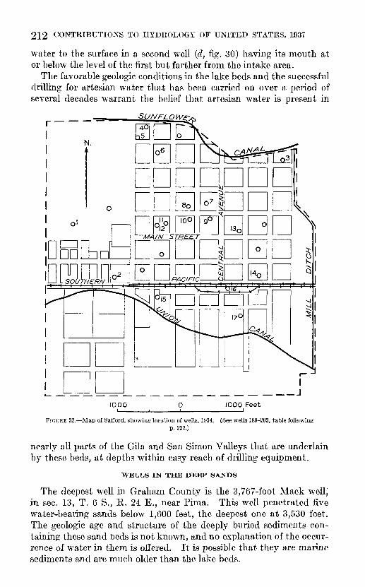
212 CONTRIBUTIONS TO HYDROLOGY OF UNITED STATES, 1937
water to the surface in a second well (d, fig. 30) having its mouth at or below the level of the first but farther from, the intake area.
The favorable geologic conditions in the lake beds and the successful drilling for artesian water that has been carried on over a period of several decades warrant the belief that artesian water is present in
DBnmn
1000 1000 Feet
FIGURE 32. Map of Safford, showing location of wells, 1934. (See wells 189-203, table followingp. 222.)
nearly all parts of the Gila and San Simon Valleys that are underlain by these beds, at depths within easy reach of drilling equipment.
WELLS IN THE DEEP SANDS
The deepest well in Graham County is the 3,767-foot Mack well, in sec. 13, T. 6 S., E. 24 E., near Pima. This well penetrated five water-bearing sands below 1,600 feet, the deepest one at 3,530 feet. The geologic age and structure of the deeply buried sediments con taining these sand beds is not known, and no explanation of the occur rence of water in them is offered. It is possible that they are marine sediments and are much older than the lake beds.

GILA RIVER AND SAN SIMON CREEK, ARIZONA 213
A well that was abandoned before 1933 was drilled to a depth of 2,645 feet near Ashurst, in sec. 30, T. 5 S., R. 24 E., about 2% miles southwest of Indian Hot Springs. It is reported to have yielded strong artesian flows at depths of 430, 620, 1,515, 2,075, 2,210, and 2,405 feet below the surface. The water of the deeper flows was highly mineralized and hot. The relation of the hot water encountered in this well to that of
FIGUEE 33. Map of Tliatclier, showing location of wells, 1934. (See wells 161-180, table followingp. 222.)
Indian Hot Springs (pp. 216 and 217) is not known, but possibly the deep water-bearing beds are the same in both places. In February 1934 a well was being drilled by E. G. Rogers in the NEK sec. 5, T. 6 S., R. 24 E., in the expectation of striking artesian flows of hot water comparable with those obtained at Indian Hot Springs and the Mack well and formerly at the Ashurst well.
The Southern Pacific Co.'s well at Safford, at the place where the elevated water tank stood in 1934, was drilled in 1906-7 to a depth of 1,820 feet. (See log, p. 202.) This well is reported to have flowed warm

214 CONTRIBUTIONS TO HYDROLOGY OF UNITED STATES, 1937
salt water for a short time. No record was kept of the temperature or of the depth at which the water stood in the well, and no chemical analysis of the water is available.
In the southeastern part of T. 10 S., R. 28 E., two flowing artesian wells, the Whitlock Nos. 1 and 2 of the Final Oil Co., were obtained in drilling unsuccessfully for oil. The Whitlock No. 1 well, shown in plate 53, A, was drilled in 1927-28. It yields a strong flow of soft, warm water (temperature 105° F.) from conglomerate at a depth of 1,445 feet, above which only clay and sand, probably lake beds, were encountered. A flow of sulphur water was struck at a depth of 1,750 feet. "Limerock" was encountered at a depth of 1,500 feet, and the well was drilled through this to a depth of 1,925 feet and finished in "sandy lime." When the well was completed the discharge was estimated by the drillers to be about 12,000 barrels (500,000 gallons) in 24 hours. The discharge is controlled by a valve at the casing head. The Final Oil Co.'s Whitlock No. 2 well, was drilled with cable tools to a depth of 1,555 feet. It discharges a ''2-inch pipe full" of lukewarm water. The depths to the water sands in this well were not ascertained.
The location of wells in the towns of Pima, Thatcher, and Safford in 1934 is shown in figures 31, 32, and 33. The data collected by the writer on these and other wells in the valley are presented in the table at the end of this paper.
SPRINGS
The Goodwill Spring, in Goodwin Wash, sec. 35, T. 4 S., R. 22 E., near the east boundary of the San Carlos Indian Reservation, is a seepage from the alluvial gravel of the creek bottom. The discharge on January 10, 1934, was about 8 gallons a minute. This spring is reported to have yielded much more copiously some years ago.
Several springs, yielding less than 100 gallons a minute in total discharge, issue along the sloping terrace escarpment that rises about 100 feet above the alluvial lowland plain in sees. 21 and 22, T. 4 S., R. 23 E. The water seems to come from the base of porous Pleistocene (?) gravel, several feet thick, which caps about 90 feet of dense lacus trine clays of Pliocene age exposed on the hillside. The water is highly mineralized and is used only for watering stock.
A spring about 1 mile northeast of Fort Thomas, near the southwest corner of sec. 25, T. 4 S., R. 23 E., yields about 6 gallons a minute. The water issues from the base of Pleistocene (?) terrace gravel overly ing dense clays of the Pliocene lake beds. The spring is used to water stock.
The residents of Eden, in sees. 28 and 33, T. 5 S., R. 24 E., normally obtain their water supply from a small spring of seasonally variable yield about 1 mile northeast of the settlement. The spring issues from a small excavation in the porous gravel bottom of a minor reen-

GILA RIVER AND SAN SIMON CREEK, ARIZONA 215
trant in the face of the lower terrace. The water is stored near the spring in a small concrete reservoir, from which it is piped by gravity to the settlement. The spring dries up during several months of each year, and drinking water is then hauled from the Rhodes well, about 5/2 miles to the northwest. The water of nearer wells is regarded by local residents as poor in quality.
A small spring in sec. 5, T. 6 S., R. 25 E., about 1/2 miles northeast of Bryce, flows from the base of porous conglomerate that caps impermeable Pliocene lake beds. The spring yields about 12 gallons a minute of water at a temperature of 68° F. and is used to water stock. (See analysis F, p. 222.)
At Bear Springs, in sees. 1 and 2, T. 7 S., R. 23 E., two springs yield water from sand in the Pliocene lake beds where these are dissected by the heads of small streams. The spring in sec. 1 yields about 2 gallons a minute but has not been used. The water has a temperature of 54° F. (See analysis G, p. 222.) The spring in sec. 2 yields about half a gallon a minute of rather salty water.
A spring yielding less than half a gallon a minute in Cottonwood Wash, in the SE/^ sec. 5, T. 7 S., R. 24 E., issues from the base of a thin layer of gravel capping Pliocene lake beds.
A spring on the Pace estate, in the SW% sec. 3, T. 7 S., R. 25 E., about a mile west of Thatcher, at the southern edge of the alluvial lowland, yields about 5 gallons a minute of rather alkaline water. The water of this spring probably issues from a sandy layer in the Pliocene lake beds.
A spring known as the Porter Spring, in the southeastern part of T. 7 S., R. 25 E., which yields less than a, gallon of water a minute, probably issues from a sandjr layer in the Pliocene lake beds. It is used for watering stock.
A spring in the NWK sec. 5, T. 7 S., R. 26 E., which yields less than half a gallon of water a minute, issues from the base of gravel capping the Pliocene lake beds, on the face of the lower terrace about 30 feet above the alluvial plain.
A small seepage of water in the bottom of Stockton Wash east of Cactus Flat, in T. 8 S., R. 26 E., issues from alluvium where formerty there was sufficient water to create a marsh covering many acres. This seepage was known as the Lower Cienaga, or Solomon Spring. The water was used for irrigation until the supply failed. The decrease in discharge is reported to have taken place shortly after the drilling of four flowing wells at Artesia in 1929-30, and the possibility is therefore suggested that the seepage rises from the artesian water sands underlying this part of the valley. The same explanation may be applicable to several small springs known as Cienaga Springs (pi. 52, B), in Jacobson Wash, in sec. 9 of the same township, and Mud Spring, in sec. 17. Several former "mud springs" in the vicinity of Cactus Flat and Artesia have become dry since artesian wells have

216 CONTRIBUTIONS TO HYDROLOGY OF UNITED STATES, 1937
been drilled. Abundant fragments of pottery near these springs give evidence that the aborigines camped in their neighborhood.
The health resort and hotel known as Indian Hot Springs (pi. 53,.B), 39 in sec. 17, T. 5 S., R. 24 E., is at the base of the middle terrace, about 5 miles from the base of the Gila Mountains and 8 miles northwest of Pima. Within the grounds five springs and a flowing well (87 in table following p. 222) have a combined discharge of about 320 gallons a minute. Most of the water runs in ditches directly to the Gila River and makes a small contribution to the amount of water avail able for irrigation. A relatively small amount of water is used at the resort, where it is the supply for several Roman baths, a large swimming pool, and the hotel.
The springs and flowing well 87 are all within 300 feet of the hotel, in a small reentrant in the face of the middle terrace. The rocks near the surface are late Pliocene sedimentary beds of lacustrine origin. Their structure could not be determined directly, because of an obscur ing mantle of gravel and soil, but faulting in them is suspected, as explained below.
Well 87 is about 600 feet deep and discharges 156 gallons a minute of water at a temperature of 119° F. Spring B yields 145 gallons of water a minute at 116°; spring D yields 10% gallons at 116°; spring A, 6% gallons at 118°; and spring C, three-fifths of a gallon at 81°. Spring E is a slow seepage of water at 107°.
Samples of water for analysis were collected from the well and from springs A, B, and C. The analyses (p. 222) show that all the samples contained a comparatively large amount of dissolved solids. The different mineral constituents were present in each sample in about the same amounts and proportions and in nearly the same amounts and proportions as in a sample of water collected from the deep Mack well 97, 7 miles to the southeast, near Pima. From the similarity in the chemical composition of the waters at Indian Hot Springs and the fact that the water of well 87 and the three springs that flow most copiously show a variation in temperature of only 2°, it may be inferred that all the water issues from the same horizon. The other springs, C and E, are cooler, and the water of the Mack well is 20° hotter.
The temperature of spring C is 35° lower than that of spring B, which is less than 20 feet distant. As these springs yield water of similar mineral content and are therefore probably supplied from the same source, the difference in their temperatures is probably due to the great difference in their rates of flow, the water from spring C being cooled to a temperature lower than that of spring B because it rises more slowly to the surface. This implies, of course, that all or a part of the ascent is made through independent openings. This
39 Knechtel, M. M., Indian Hot Springs, Qiaham County, Ariz.: Washington Acad. Sci. Jour., vol. 'in, no. 9, pp. 409-113, Sept. 15, 1935.

GEOLOGICAL SURVEY WATER-SUPPLY PAPER 796 PLATE 53
A. FLOW OF WARM WATER FROM FINAL OIL CO.'S WHITLOCK NO. 1 WELL.
In sec. 36, T. 10 S., R. 28 E.
B. INDIAN HOT SPRINGS.
Springs are in background; flowing -well is at concrete tank in foreground.

GILA RIVER AND SAN SIMON CREEK, ARIZONA 217
explanation also applies to the temperature of spring E, which is 9° lower than that of spring B.
The temperature of the well water and the three principal springs at Indian Hot Springs averages about 117°. If it is assumed that the water rises from a depth of only 600 feet, the depth of the well, then local unusual thermal conditions must be invoked to explain the high temperature at this comparatively shallow depth below the surface. It is probable, however, that the water comes to the surface through fractures, perhaps caused by faulting, from an artesian source much deeper than 600 feet and that the well merely taps the upward- moving streams. If there were an increase of 1° in temperature for about each 57 feet of increase in depth, as suggested in the following paragraphs, the water would rise from a depth of about 2,500 feet.
DEPTH-TEMPERATURE RELATIONS
Most of the depths of wells, especially of the deeper wells, given in the table of well records (following p. 222), were reported to the writer from memory by various persons, some of whom had in turn acquired their information by hearsay. Most of the water temperatures are those observed by the writer at the mouths of flowing wells and probably are slightly lower than the temperatures of the water at depth. Some heat is lost by the water in its ascent to the surface, especially in wells that have only small flows, and as many of the wells are not cased the water issuing from a given well may come from several horizons at which the temperatures differ. In general, however, by far the greatest discharge is from the bottom of the well, and the cooling effect of water from higher levels is small.
A depth-temperature study of the field data on 78 wells was made by H. C. Spicer, of the Geological Survey, and his computations, which with one exception were based on wells ranging in depth from 100 to 1,450 feet, indicate a rise in temperature of 1° F. for each 57 feet of depth. The temperature of about 135° F. for a depth of 3,540 feet, as computed from this gradient, checks surprisingly well with the measured temperature, 138° F., of the water flowing from the mouth of the Mack well, in sec. 13, T. 6 S., R. 24 E., most of which comes from a horizon at that depth.
CHEMICAL CHARACTER OF THE GROUND WATER
By E. W. LOHK
The chemical character of ground water in the valley of the Gila River and San Simon Creek is indicated by partial analyses of sam ples from 5 springs and 44 wells. The analyses made by the Geological Survey indicate the suitability or unsuitability of water for industrial use, for irrigation, and for domestic use so far as such use is affected by the dissolved mineral matter. They do not show the sanitary condition of the waters examined.

218 CONTRIBUTIONS TO HYDROLOGY OF UNITED STATES, 1937
The chemical constituents determined (see table of analyses, p. 222) are iron, calcium, magnesium, carbonate, bicarbonate, sulphate, chloride, fluoride, and nitrate. Sodium and potassium were calcu lated as sodium. The total hardness was calculated when both the calcium and magnesium were determined; otherwise it was determined by the soap method. Silica was not determined, and iron only when an amount in excess of 0.1 part per million was noted to be present. The silica present in the waters will probably average less than 20 parts per million, and the iron less than 0.1 part per million. The figure for total dissolved solids was obtained by summation of the mineral constituents, both calculated and determined, silica not being included. The usual methods of analysis 40 were used. The fluoride was determined colorimetrically.
The 49 samples examined are mainly sodium chloride, sodium car bonate, and sodium sulphate waters and are rather highly mineralized. There are only three calcium carbonate waters and a few that are of mixed type. Sodium is the chief basic constituent in 46 of the waters. Chloride is the main acid constituent in 32 of the samples, carbonate in 12, and sulphate in 5. The concentration of these three acid con stituents is rather high in nearly all the waters.
The high mineralization of the ground waters is due chiefly to the aridity of the area and to the lacustrine origin of the geologic forma tions through which the waters largely percolate and from which most of them flow or are pumped. The rapid evaporation of the water from the surface causes a concentration of soluble salts in the top layers of the soil, and the water that percolates downward to become ground water is therefore more highly charged with mineral matter than percolating water in a humid area. Moreover, sediments which are deposited in lakes that do not overflow are commonly impregnated with soluble salts, and the lacustrine origin of the principal sedimen tary deposits of the Gila and San Simon Valleys may therefore account for the rather highly mineralized waters of the region.
The quality of water that may be considered satisfactory for drink ing and for domestic use depends on the locality and the individual. The limits adopted by the United States Treasury Department to govern the quality of water used for diinkiiig on interstate carriers 41 have been widely used as general standards for domestic water supplies. The published standards indicate that the limits are not expected to be very rigidly enforced. It is common experience that many waters exceeding the limits in some respects have been used for long times without any apparent harmful effects. The limits suggested by the
<»Collins, W. D., Notes on practical water analysis: Geol. Survey Water-Supply Paper 596, pp. 235- 260, 1928. Foster, M. D., Colorimetric determination of fluoride in water, using ferric chloride: Ind. and Eng. Chemistry, anal, eel., vol. 5, pp. 234-236, 1933.
« Drinking-water standards; standards adopted by the Treasury Department June 20, 1925, for drinking and culinary water supplied by common carriers in interstate commerce: Public Health Repts., Reprint 1029, April 10, 1925.

G1LA RIVER AND SAN SIMON CREEK, ARIZONA 219
Treasury Department are total solids 1,000 parts per million, iron 0.3 part, magnesium 100 parts, sulphate 250 parts, and chloride 250 parts.
Of the samples examined from the Gila and San Simon Valley only 25 were within the limits suggested by the Treasury Department, but several others were not far from the limits and are reported to have been used without injurious effects.
Water that is satisfactory for domestic use may be unsuitable for industrial use. For industrial use hardness is the most generally objectionable characteristic. Water with a hardness of 100 parts per million is neither satisfactory nor economical for use in laundries nor for use without treatment in steam boilers. Hardness is chiefly caused by salts of calcium and magnesium. These constituents, with silica and iron, make up practically all the scale found in steam boilers and cause much of the trouble encountered in steam-boiler plants.
The waters analyzed from the valley of the Gila River and San Simon Creek do not contain large quantities of calcium and mag nesium or iron, and in this respect they would be satisfactory for most industrial purposes. About 60 percent of the waters have hardness less than 100; about 30 percent have hardness between 100 and 300; and the remainder have hardness greater than 300.
Although these waters do not contain scale-forming constituents in large quantities, most of them contain large amounts of sodium salts and would be likely to cause foaming in boilers. Some might even cause corrosion if used in boilers operated at high ratings.
The successful use of water for irrigation depends on a number of factors in addition to the composition of the water. Among these are the character of the soil, the amount of water used, rainfall, and drainage. Scofield 42 in 1933 suggested limits for certain character istics of irrigation waters. In general, waters within the range speci fied in the lower set of limits are not likely to be harmful when used in ordinary irrigation. The upper limits, however, represent con centrations that are very likely to render the waters unfit for irrigation, either because of their effects on the plants or because of their effects on the soil. Concentrations between the upper and lower limits may not cause injury to crops and soil, depending on the composition of the water, the characteristics of the land, and the manner in which the water is used. The following table shows the suggested limits:
Suggested limits for safe and unsafe waters for irrigation
Constituents
Sodium (Na)._ _____ _ . ____________ _Sulphate (SO 4)-. . .- -- -.Chloride (Cl)___.__.__ _ _______ do
Safe: Less than
70050
192
Unsafe: More than
2,00060
480355
42 Scofield, C. S., Quality of irrigation waters: California Dept. Public Works, Div. Water Resources, Bull. 40, 1933.
220 CONTRIBUTIONS TO HYDROLOGY OF UNITED STATES, 1937
The percentage of sodium is obtained by dividing 100 times the figure for sodium by the sum of the milligram equivalents of calcium, magnesium, and sodium:
NaXlOO , A, -^ j-^r-p 1-^-= percent NaCa+Mg+Na 1
With these limits as a standard for classification, about one-third of the waters analyzed from the valley of the Gila River and San Simon Creek would be classed as safe for irrigation, one-third as not determinable from the factors in the table, and the remaining third as unsafe.
The presence of fluoride in natural waters has been known for some time, but the relation of the occurrence of fluoride in water to the dental defect known as mottled enamel has only recently been generally recognized. Residents of the Gila and San Simon Valley, especially natives, are commonly afflicted with this dental defect, which is thus described by Smith and Smith: 43
There are certain sections in Arizona and many parts of the world where every native-born inhabitant has the peculiar defect of permanent teeth known as mottled enamel. Mottled enamel is frequently referred to as "brown stain", or simply "stained teeth", but the staining is a secondary phenomenon and should not be confused with the defect itself. The most outstanding characteristic of mottled enamel is its dull, chalky-white appearance. Sometimes the whole tooth has lost its translucency and presents an unglazed appearance, but in milder cases paper-white areas are distributed more or less irregularly over the surface of the tooth. The enamel may or may not stain later, the color of the stain vary ing from almost black through orange-red to yellow, hence the name "brown stain." Usually all of the teeth, though they may be mottled, are not stained, the stain being more pronounced on the upper central incisors. The general tend ency is for the stain to follow the lip line, and this fact suggests that exposure to air and light may be a factor in its production. In severe cases of mottled enamel, the enamel is so defective that it is badly pitted and corroded and the teeth are structurally weak, the enamel tending to chip off. Mottled teeth, though perhaps no more subject to decay than normal teeth, do not hold fillings well and deterio rate more rapidly. False teeth among young adults in a community in which mottled enamel occurs are not uncommon. Mottled enamel is primarily a defect of the second or permanent set of teeth, for only rarely have cases of mottled enamel of the temporary or deciduous teeth been observed.
As to the toxic concentration of fluorine in drinking water, Smith 44 has stated:
No Arizona water has yet been found containing as much as 1.0 part per million of fluorine which has not been demonstrated to cause mottled enamel, and no water with a fluorine content less than 0.8 part per million has been found to be associated with mottled enamel.
The presence of toxic quantities of fluorides in waters in Graham County appears to be associated with a high content of sodium salts and with soft water rather than hard.
43 Smith, H. V., and Smith, M. C., Mottled enamel in Arizona and its correlation with the concentration of fluorides in water supplies: Arizona Univ., College Agr., Tech. Bull. 43, p. 284, 1932.
44 Smith, H. V., Determination of fluorine in drinking water; comparison of several methods and estab lishment of toxic concentration by these methods: Jnd. and Eng. Chemistry, anal, ed., vol. 7, p. 21, 1935.

GILA RIVER AND SAN SIMON CREEK, ARIZONA 221
The fluoride content of the waters analyzed from the valley of the Gila River and San Simon Creek ranged from 0 to 15 parts per million. Only 2 samples gave no test for fluoride, 9 had 1 part per million or less, and 20 samples had more than 5 parts. In the samples that were examined the smallest quantities of fluoride generally were found in water from wells less than 200 feet deep, and the largest quantities were found in water from wells more than 800 feet deep.
There is at present no cheap and efficient method known for remov ing fluoride from water for domestic use.
It seems obvious that drinking-water supplies that will be used by young children should be taken only from wells whose analyses indi cate very small amounts of fluoride. Probably in most neighborhoods at least one convenient well supply will meet this requirement.
ANALYSES AND WELL RECORDS
The accompanying tables present data that were collected concern ing 435 wells in the area examined. Analyses of some of the waters are given in the one on page 222.
222 CONTRIBUTIONS TO HYDROLOGY OF UNITED STATES, 1937
Analyses of water from wells and springs in the valley of the Gila River and San Simon Creek, Graham County, Ariz.
[Parts per million. Numbers correspond to well numbers in following table. Letters A, B, C, F, and G refer to springs described on pp. 214-217. E. W. Lohr, analyst]
No.
2 3
1659 73 87 AB097 F G
130131132135143154155182 189190 224
?45246253 257258271273278285286295
3053ns309314320328332356358392409430432
Date of collection
Nov. 22, 1933. Nov. 23, 1933. Nov. 22, 1933-Nov. 23, 1933- Apr, 7, 1934 Nov. 20, 1933. .do do - do --.Nov. 30, 1933. Feb. 9, 1934 Nov. 9, 1933- do do . .do. .... do. _ Dec. 27, 1933-Feb. 16, 1934.. do ---July 23, 1934.. Apr. 11, 1934-July 21, 1934.. Apr. 3, 1934 do Dec. 19, 1933- do ....Jan. 22, 1934- Feb. 13, 1934.. -do -Nov. 17, 1933- do -Nov. 18, 1933-Nov. 16, 1933. do do do ._ .Nov. 15, 1933.Nov. 18, 1933_Nov. 17, 1933-Nov. 16, 1933- do Nov. 18, 1933.Nov. 17, 1933_Nov. 18, 1933,Nov. 17, 1933_Feb. 2, 1931 Nov. 13, 1933.Nov. 7, 1933_ . -do -_.
Total dis
solved solids (calcu lated)
531 296
14, 035U92
136 2,568 2,996
3,4553,351 1,715
228 500
4111,282
2172,880
1,672 1,0451,133 1,081 1,080
1,1661,873
6771718
8071,682
1,479
577944
651225163786
1,024940
Cal cium (Ca)
47 33
133422878 7880
10273 62 44 399722
902 1
236226158 129141
77
211
602012102 172540
2 102 22 730
2 52 10
228
21027
21626
21823328
Mag nesium
(Mg)
12 6.5
8512 5.1
10 9.09 4
7.2 27 7.2
9 2
8.5
si2627 23
1762
2.2
Sodium and
potassi um
(Na+K) (calcu lated)
14071
11 15
878 1,0431 048
1,190 540 38
142305
36987
1,085891388 231252 305oni
387
286280
313658332512209221361275725489231
8842
310239167389
Bicar bonate (HC03 )
244 152 492144 100 106 98
10011496
178 240 124102163112«91
60
507 446513 486
276526484 220218'65
4846024317646
11660
'85866
5617012213096
152128205
Sul phate(S04 )
80 50
1,83850
234 357 404405518419 319
2 1084
211
269250564521325 115121 158
270192437 262211164349180370193389134136223172512333211130220176174171347319
Chlo ride(Cl)
130 59
6,6566.0 4.0
1,190 1,4101,4201,5801,610
675 10
168450
49038
1,265970480 305315 260
195260500 83018125155087
5902685101431733452307404801254516
280150124215197
Flu- oride(F)
2.0 1.2 4.5.2 .4
3.3 3.74.14.34.9 3.3 .8 .0
1.6
.05.07.17.3.2.8.6
3.3 3.2
5.81.6 1.21.6
15145.37.85.3
138.76.1
141310136.14.4.4
10131.2
1112
Ni trate (N03)
0.0 .70
.0
.50
.0
.0
.0
.0 1.2 .20 .50
.20
.0
.10
.50EA
20 1824 15
.704.7
46 .50.50.0.0
151.0.0.0.10.0.0.10.0.0.90.10.0.0.75
1.1.0.0
Total hard
ness as CaCO 3 (calcu lated)
167 109
154 91
236 232OOQ
304212 266 140 118280
(34)
260(34)
*81* 48604 429463287
*28220757 422*3648
109432*8
*16
84*9
* 164 2049
*814404 504 144604104334994 16
4 14
1 Iron (Fe) 0.65 part per million.2 By turbidity.3 Less than 5 parts per million.1 Determined.s Includes equivalent of 30 parts of carbonate (COs).6 Includes 0.8 part of borate (BO3).7 Includes equivalent of 18 parts of carbonate (COs).8 Includes equivalent of 12 parts of carbonate (COs). Includes 1.4 parts of borate (BO3).
Record of wells in Graham County, Ariz.
[Compiled by M. M. Knechtel]
No,
1
2
3
4
5 « 7
8 9
10 11 12
13
14 15 16
1718 19 20 21-22 23 24 25 26 27 28 29 30 31 32 33 34 35 36 37 38 39 40 41 42 43 44 45 46 47 48 4950£1 62 63 54 65 .56 57
58 59
60
61 62
63 64 65 6667 -68
69 70 71 72 73
74 75 76 77 78 78 SO 81 82 83 84
85 86 87
88 89 90 91 92
93 94 96 90 97
98 99
100 101 102 103
104
Location
T. 4 8., R. gg E.
NEMsec. 13 __ ....
SWMNWM sec. 13.....
NEMNEM sec. 24. __
.. do.................
SEMSWM sec. 24 NEM sec 26SEMSEM sec. 26.......
T. 4 8., R. US E.
tJof 17NWM sec. 18. _____ NE'i, - 18...... .. .M \\ 1 1 ' 1 U ««p ISSWM^EM sec. 18. .....
SWMsec. 18 ...........
.. do................. ..do.................NWM sec. 19 _____ .
NWMNWMsec. 19_._.SW^NWM sec. 19 __ . NW^N-.M sec. 19 NEMNEM sec. 19 __ .. __ do _________
NWMNWM sec. 20 . SWMNWM sec. 20 .. do..... ___ . .....NWMSWM sec. 20. .... SEMSWM sec. 20 .-do-... _____ .SWMSEM sec. 20. .....
.. ..do _________SEMSEM sec. 20 NEMSEM sec. 20 Sec. 26. _ - _____NWM sec. 27 NEMsec. 27 ___NEMSEM sec. 27 SEMSEM sec. 27 SWMsec. 27 .........NWMNWM sec. 28 SEMNWM sec. 28 NWMSWM sec. 28 NEMSWM sec. 28 __ .SEMsec. 28- ______NWM sec. 29 ...........NWMNEM sec. 29. ....
SEMNEM sec. 29 SWMNWM sec. 34 ..... NE'MNWM sec. 34 NEMsec. 34 ___ ..SEM sec. 34 _ ......NWM sec. 35 ........NWMSWM sec. 35 _ ..do ___ . _____ ...... do.................SWMSWM sec. 35 NEMSWM sec. 35...-SEMSWM sec. 35
T. 6 8., R. SI E.
Sec. 23 . ..............Sec. 27
Sec. 36 ......... . ...._
T. 6 S.t R. gg E.
Sec. 3. .........Sec. 8 ..... .....
.....do... ............ ..Sec. 18. _ - _____ -Sec. 25. ....... .Sec. 26... .....Sec. 27... __ . .........Sec. 29.. __ .... __
T.B8.,R.fSE.
Sec. 1.. ___ . __ .NWMNEM sec. 2 "WMNEM sec. 2... ....N\V 4 KMsec. 2 NEMSWMsec. 2_. __ .
NEMSEM sec. 12 SWMSWM sec. 12 SEMSWM sec. 12. _ SWMSEM sec. 12. .....SE^SEM sec. 12. ......Sec. 13. __ . _ . ......Sec 14Sec. 19. ................Bee. 24... ....... Bee 30
T. 6 S., R. S4 E.
Rev 7
NEM sec 17
NEMNEM sec. 29 SEMNWM sec. 28. _ ...Sec. 30..- ..... _ .....NEMNWM sec. 33 NWMNWM sec. 33 ....
T. 6 S., R. 84 E.
Sec. 1- ..... ....... -
NWMSEMsec. 10 SEMSWMsec.il NWMNEM sec. 13
SWMNWMsec. 24 Sec. 35... ..........
T. 6 S., R. tB E.
Sec. 7,- __ ___ .SEMSEM sec. 17- __ .NWM sec 17NWMNEMsec. 19 __ .
NEMNWM sec. 19
Owner or name
.....do. _ . ............... do.. ...... .......
S. J. Curtis _ .......
E. W. Black
H. A. McBeath J. G. Willis.. _____ - ...
..... do-_ ... .... ...
E. W. Black.
R. H. Henry ...........
Mrs. B. D. Wilson ........ T. L. Willis.. ___________
State of Arizona... ._._._._
J. H. Fine _________
Mitchell _ __ _..._...
Walker.. ..................J. H. Fine-. ___ ........
Southern Pacific Co ....... T. S. Rex __________Mrs. L. Cornett __
J. B. Hinton ______ ...
m
.... .do. ....... ...
.do. ___ .(?)
Y L home ranch. .........
W. O. Tuttle-.. ......
W. C. Rhodes.. _._....
W. H. Roach. _...........G. A. Todd ...........
W. A. Pitt . ____ ... "Lowor" well
do. _ ....... .Indian Hot Springs;
"Beauty Spring". Eltgh Saline. ___
Gila OU Syndicate ........
H. L. Smith _____ .....
G. B. Maloy.... __ ...... W. S. Stewart __ . .....
J Tjy TTalaTiQTxr
S. S. Marshall ___ ......W \xr Prnflrnf-t
J A Echols
Topographic situation
Alluvial plain. .... _____
_____ do........ .
.....do ...................
. do.. __ ...........
.....do.. _ ..._.__. ... _._.
. __ do ...... ...... ..._____ do. ..........
-_--. do...... -__.._.. ........ do do. do.
do. _______ .... do. .do.. ........ ... ...
do....... .... ........ ...
..... do ...... .... _ .do ______ ..... .... .....
do ___._ do........ __... . _____ do .... ... ..... do ._ do ..... ... ..... do ..... .... ........ do- ... ..do.. ..... .... do do __ do __ _ .___. __ .do ..... ........ ._ - .__._ do ..... ..___ do. __ ... ... _ do ..... ..... ... _____ do....... do ... -do. ..... .... ....... do _...._ ..... ... do- __ ................. do . __ do _ . __ ..... .............. do__ .... do. ....... do _ ..... ... ....... do __ .do _ ........ ....... ......... do.. ... ..... ....._____ do............ ........ - ..... do ........ do _ ... ...... ..... _ -
do . ...._____ do... ..... ... ..... do _ .... ___ _ ______ ..... do.. .____. do.. ... __._-
_._._ do._ ......... ...._.__. do. .___. ........
... __do._ ......... ._.__
do ......... ..... do
do. ......... do... ........ ... ..do.. ........ .....___.. do ... .... ............ .. do... .........do......... ...........
.____do ...... __ __.__ do.. ___ ........... _do _.--...- ........ -..... do ... ... ........ ... do. ................ .
Alluvial plain ...............
..... do-.... ..... .... ...
.....do _ ...... ......... - do-.. do __..__. ...............do-.. ... .......... ......do... .__... ........ ..... ......do.. .............. ._ doL __ .. ........
.....do. __ .................__ .do...... ................ do. _ ... ...
do. _ ..... ....... ..... . do. _ ....... ....... .... do, ___ .......... ...__... ..do.. ..... .... .....do........ .... .......
.....do. _ ...... ........ .... do. _ . .....- ..... do,- .... ........ .... do. do. _ ..................
__ .do. do. _ ............. _ -
do.-. ... ......... .... __ do. _ .... ..... .......... ..do _ _ ... .........do... .... ........ .
do
Type
Dug.. ......
do. _
..... do.
do.
.....do. _ Drilled ......
DrilledDug.
do. ..... do.
do _ ...
. __ do...... do. .....Drilled- ....
Dug. -
-do Drilled do...
do... ....
Drilled __ .do ___ . do Dug . ....Drilled do ...Dug
.....do ___ .Drilled do Dug __ do _______Drilled _____ do. do-Dug- __ - Drilled
__ .do ... . do ....Dug. _ .
Dug . .Drilled do. ..... do Dug- ... ..do ....Drilled
Dug ...
Ttrillorl..... do
do __ ..... do
.....do _ ...
.....do...... do .
do .....do ........ do ... . .do-.. ..... do ......... do... ....
... ..do ..
Drilled. ..... do...... . Dug... ......
TtrilWI
Dug. ... Drilled . .... Dug .. Drilled _ _do
do .._ do ___ ..do . do .-..do ~ ..
Drilled
Dug .___.__.Drilled. .....
Dug... .....Drilled ...
Dug . .....
Drilled... ...
do
Depth (feet)
18
29
50
38
32 52
25 10 33 30
42
36 810
45 30 30
102 50
40
50 38 38 48 49 40 28 10 16 40 40 10 10
30 30 47 30
45 41 35 49
47 /Filled I in
21 42
27 30 27 60
80 40
20
65 92
72 96 80 73 54
30 30 26 42 60
60-70 16 60 21
40 40 90 70 37 80
35 41
600±
60 2,645
21 380
100 800
32 40
3,767
63 15
40 21 16 30
30
Diam eter
(inches)
72
144
4 4
472 60 60 60
60
5 72
6
60 48 72 6 4
4
72 7 4
48 5 6
60
6 6 6
60 6
5 60
60 6 6
} 120
3^
6
6 84
48 6
36 4
6
6
37
36
4
(«)
144
Geologic horizon
Quaternary alluvium ...
.....do. ___ ...... ..
do. ___ ...........
do... . ___ . __ .
.....do. .............. do . ____ do ..................
do. _ ........... ........do. __ ......... . do.. __ _ ....... do. __ .... ... do. _ ... ...... .
Pliocene lake beds (?)
do.? - ...... Quaternary alluvium ...
Quaternary alluvium. _ do __ .. .......
..... do ..... ...... ....do
..... do .... .....
do __ ...... .do... ... ........ do ..... ... ........... do ..... ..... ..........do... ............. do ..... .... ....__ do.. _.-.._.._ ._- ._ do .... .....-_.- do ..... ..... do .... ....... do ..... ... ....... do ... ... ........ do ... .... .... do ..... do .... .... .... do ....... do ____ . ..... do ______ ..... do .... ... ... ... . do .... ....... ..... _ .do ______ ... __ .__ .do... _____ ... _..... do ..... ...... .... do. _ ...._.-_. do... .... ...... ..... do... ..... .... ... do.... ... .... ...... _ do _ do _ __ do _......_ -._-_-- do-_ ...... ....
Quaternary alluvium ...
. do... ...... ... ... .do ..... .... ......
. _ .do _.__. do ................
do _ ...............
__ .do -._.____....-..... do _ ...............
..do.... ..........do __ ......... .....
do, . ...
_.do_ ......... ...........do. . .....
do ___... ..do. _ .... ___ ...._____ do -.. _..._....... do ...... ... ... do... .............
Quaternary alluvium _ _ do _ . _____ do.... ___ ........
do -..... do ... ....... .. do - __ .. .... . .do.? ..... do.?. __ . __ ......
.....do.? ......
do_ ........ do. _ -.-..-.
Quaternary alluvium _
Quaternary alluvium ...
do __________Quaternary, alluvium. . - __ do _______ do.. Pliocene and Paleozoic?.
Quaternary alluvium _ . __ do.. ____ ........
.... .do.. .............
.....do. _ ..............
do.- __ .....
- do-r? -
Water level
Dis tance below surface (feet)
15
26
30
30
10
20 23 7
3128
40
51 35
35^ 28 29 27 32
35
50 18 35
15 9
15 14 10 9 9
24 28 45 28
40
47
20 40
25 27 2548
30 30
19
7M67
70 61
34 30
20 29 25 34 41
15 30 17 20 22 20
35
32
24
20
20 35 30 38
12
30 20 15 10
18
Date of measurement
Nov. 22,1933
do. _ ...
Nov. 23, 1933
..... do..
Nov. 22, 1933 ..... do. ...... do.......
.... .do.
..... do..
.....do. _ ...
..... do..
..... do..
Nov. 23, 1933
..... do..
..... do...... .
..... do..
.....do. _ ... do Nov. 22, 1933 do __ .do.. ......
do ...Nov. 24, 1933. do ..... do ..........do ......_ .do .......... do... .....__ .do ..... do .......... do ..... do... ...... do ......... do .... .do... ..... do ...
Nov. 24. 1933
Nov. 24, 1933 __ do . .... do.. ...... do.......__ do... .........do .......... do ...... _ .do.... ... ..do.. ..... do ..... do. __ .do. _ ........ do ........ -do __ do ......... do ... do ...... do. .
Nov. 23, 1933 .....do .......
. _ .do _ ....
.....do.......
..... do.. .
do . do. Feb. 14,1934
.....do........
..... do ... do
Nov. 25, 1933 Nov. 24,1933 ..... do Nov. 25, 1933
.... -do... .....
Feb. 15,1934 Nov. 25, 1933 __ do ........... ..do ..... _ do .... .do. ..... do ...... -do... Feb. 15,1934 Nov. 25,1934 Feb. 15,1934
Nov. 25,1933 .....do. _ ...Nov. 20, 1933
..... do... Nov. 25, 1933 __ do ............do............ do...... .
.... .do ... .do ___ . do __ - ..do.. .....
Nov. 25, 1933 Jan. 6, 1934
Dec. 5, 1933
do. _ ........do. __
do
Method of lift
Gasoline pump, . .. _ .
Delco pump ..................
Double-action Fairbanks- Morse gasoline pump.
Windmill... __.....do... ......................... .do. ...... ..........
Hand pump __________
Gasoline pump ..._......._...
Windmill.. _ . ____ .......
.....do. ___ ....... __ ..... .do. _ ..... _ . __ .......
Windmill. do... ...................
do .......... ...... .....
Windmill
. _ do ______________ do ..... ..... ... ........ do .................Windmill ____________
Windmill- . _____ ... .......Hand pump ______ .....Windmill. _________ . ...
Windmill ________ . ...... do ..... ... ... .... ........... do. .... ..... .... ..... do ........ ......... ... do ......... ...... .- do.. ... ........
Windmill ___________ . do ... __ .... ..... ...... do- ___ do ____ . __ .......Hand pump __________Windmill.. __ ...............
Windmill. do _ ... ...... ....... .....
do ........ .... ...
Windmill .....................
Windmill ..................
-do. ... .... .... .... .....Windmill (out of commission) - Windmill.. __ .. ______ .do ................... ... .do ...... ... ... .....
Windmill __ ............
Windmill.. ____ .... __
. __ do _______ __ .
Artesian flow. ___ _ ...Windmill. ....................
Windmill.. __ ..........
__ do ________________ do __ . ___________
Yield
Rate (gal
lons a minute)
21
156
(0
0)
2,250±
Date of measurement
Nov. 22, 1933
Nov. 30, 1933
Use of water
Domestic, automobiles ...
Domestic and locomotive. ..
do. ___________
Domestic, except drinking..
. .do. __ .................
do. ............. ..do. _____ . ...........Medicinal (locally) ..........
Abandoned .................
.... .do .... ...... ... .....
. do .... ... .... .....- do _ ........
do _ .............. do _____ .. _ .do - ._._..._..-. - do. __ ..... do ........ ... ...... do ___________ - do ....... ..... .... .. __ do. __________ .. ..do ........ ... ...... do ... .... ........ do ....................Stock.. . -._____-- _-...
. __ do ____________ . do ____ . do .... ..... .... ... .... do . __ ......... do ........ ... ... ..... do __Stock do _ .... ...... ... ......
Stock. _ ... _ ....
Stock. __ .....
do __ ... __ .......
Stock.. __ ..
do ... ....... ...... .Stock. ______ -
..... do .. ......
.....do ... ... ......... ..... do . .....Domestic and stock. .....
Stock.... ......... . ..
do. _ ..................
..... do.................-. .Stock...... __ . __ ..... ..do ....................Abandoned __ .............do... ................. do- ...............
do ..... ....... ..do .... .........Stock.. ... . ...... ..do... .............. . ..do.. ...............
do ...
Swimming pool and do mestic.
Stock _______ ... ....... do.. ____ ....Abandoned _____ . __ .
Stock. __ ....... __ .......
Domestic.. _ ........ do.... __ ... __ .......
.....do .................
Stock.. ____ .... ...... do. _ .......................do. __ ........... .....
Abandoned. - ___ -
Tem pera ture
(°F.)
63)..
67
67
65 63*.
82
6766)..
67
57*. 64
119
73
138
Remarks
Two wells close together. Water rises to surface in wet weather.
See analysis, p. 222. In gravel, alternating with layers of sand and clay.
See analysis, p. 222. Two or three small flows above bottom of well.
Used for irrigation during 1916, 1917, and 1927. Irrigated about 25 acres with pump running part time.
Copious Sow. Two wells close together. First flow. Walled with concrete. Hard water. Water about 5 feet deep in wet weather. Used for drinking by many families. Copious
flow. Water Is probably from third flow. Walls
bricked.
Walls cemented. No increase in Sow below 495 feet. Well was
drilled for oil. See analysis, p. 222. Well cased to 200 feet.
Third flow. 15 feet west of flowing well. Walla bricked.
Water rises several feet in wet weather. Four flows. (See log, p. 201.) Water is from third flow. Cased to depth of
50 feet.
Three flows. Second flow.
First and second Bows.
Salty water. Do.
Do. Do.
First flow.
Salty water.Water supplied old Fort Thomas and was also
used in making ice.
Gasoline station.
Top of principal water-bearing bed 30 feet deep. See analysis, p. 222. Top of principal water-bearing
bed 30 feet deep. Top of principal water-bearing bed 20 feet deep.
Top of principal water-bearing bed 92 feet deep. 2 wells close together.
Top of principal water-bearing bed 72 feet deep. Top of principal water-bearing bed 80 feet deep. Three water-bearing beds.
Do. At mouth of Telegraph Wash.
See analysis, p. 222- Domestic supply for many families.
Three aquifers.
Do.
Partly filled In. Concrete reservoir at mouth of well. See analy
sis, p. 222.
Water shut off by wooden plug. (See p. 214.) Salty.
Do. Unfinished. (See pp. 201 and 214.)
The "Mary 8. Mack" well. Drilled for oil. (See analysis, p. 222.)
No. 1, fig. 31. Used only when municipal supply fails. - _ _ 'i W
No. 2, fig. 31. * .** £ \{
1 Slow seepage.> 24 inches at top; 6M inches at bottom. V 149555 38 (Pace p. 222) No. 1

Records of wells in Graham County, Ariz. Continued
No.
105 106 107 10S 109 110 111 112 113 114 115 116
117 118 119 120 121 122 123 124 125
126 127 128
129
130
131
132
133 134 135 136
137
138 139 140 141 142 143
144 145 146 147 148 149 150 151 152 153 154
155 156 157 158 159
160
161 162
163 164 165 166 167 168 169 170 171 172 173 174 175 176 177 178 179 180 181 182 183
184
185 186 187 188 189 190
191 192 193 194 195 196 197 198 199 200 201 202 203 204 205
Location
T. 8 8., R. SS E. Con.
NWJiSWJi sec. 19 ...--do . ..... _ ..SWJiNWJi sec. 19 NEMSWJi sec. 19 SEJiSEJi sec. 19. __ do __ . ______ .. . do ..... ..... ... do .... ... ..... ... do SEJiNWJi sec. 33 NEJiSEJisec.34......SEJ^NEJi sec. 36 -
T. 6 S., R. *7 E.
SEJiNEM sec. 35 .SWJ^NWJi sec. 36
SEJiNWJi sec. 36.
NEJ£SWJ£ sec 36
SEJiSEJi Sec. 36 SWJ£SWJisec. 36. __ -
T. 6 S., R. 08 E.
SEJ^NEJi sec. 31 __ -
NWJiSEM sec. 3i.__.__
T. 7 S., R. S3 E.
SWJisec. 1.. ......... .
.. do .........
do
-do ....... .......
..do.. .... .....SEJi sec. 2 .... ...
SWJisec- 16-. _ -
T. 7 S., R. 84 E.
Sec. 2.. ................
SWJisec. 4 __ . __
SEMsec. 5 ..... ..... ..do ... ... .... -.. do ....... ......NF^RFW SAP 7
NEJ^sec. 8 ______ . -do ..... ........- do...... ............ do ... .... ... ..... do NEJ^sec. 12 ..... .SEJ£ sec. 12- ........SEM sec. 13 . ... .. SWMsec. 13 do ... ..........SEMsec. 14. ...........
-do ........ ... .... do ..... ..... . do ... ..... ..... do Sec. 17 .................
Sec. 24 __ ........
T. 7 S., R. SB E.
SEMNEJi sec. 2... ....
NEMSEJ£sec. 2
-do .NWMSEJi sec. 2... ....RWL^'S'PLf «<M> *>
SEJ£SEJ£ sec. 2. .......
NWMSWJ4 sec. 2
SWUSWM sec. 2 ....__ do .NEKSEJi sec. 3 ...SEMSEM sec. 3 ........NWM sec. 11 . ... do. ......NEMsec. 11.. __ ... .
NEMSEMsec. 13 Ran 97
T. 7 S., R. 96 E. NEJiSWJisec.5......
SEJ^NWMsec. 5...... SEJ^NEJi sec. 6.. _____NWJ^NEJi sec. 6 ......NEJiNWJi sec 6NWJiSEJisec.7._.__.SEJ£SEMsec.7
do.. __ ..NEJiSWJisec.8.-_...NWMSWJi sec. 8 ...
NWJ£SWJ£ sec 8SWJiSWJisec. 8. __
do. ___ ...... ....._ ..do. _ ...... ___ . do. do.. ..... SEJ^SWJi sec. 8-. ._.. do. . ..... ..SWJ^SWJisec 9SWKSEU sec. 9
Owner or name
Paul Nuttle _______ -
-do .3. H. Lines ...
J T Traylor
__do_______-_ ..___.___...
"Pofrir-V Tavlr.!-
.. do .... ... ........
. .do ..... ....
.do . __ ...
.do _________ ._ ..do.. _________ . .do ... ... ..... ....... .do ..... ... ... ......
G. W. Hill .........
City Utility Co ...........
..... do ... ... .... ... do .
City Utility Co . ... .
-. do .... ... ___... -do... . . ......J. R. Walker .B.H. Cluff- A. R. Evans ___... .. do .. ....... .do.. ... ............. do .... ....
- do __ .. do ___ .....-. do ..__.. ......
Hn
Tvlnr?- do.? . __ ..
0. Jolly _ .
3. Alien __ .......
W. 3. Windsor. _ .P. Cluff ______ .
A TatoW. A. Posey _______ .A.F. Tyler.. ___ W. Taylor J. D. Lee
Robert Phillips. ____ ..
W. A. Adams .............R. A. Smith ________ do. . _ . _______
3. Golden __________'William "WaHHoll
C. Cratts _________Theater ________W. M. Kirkland _____
Pursley & Nash _____
Topographic situation
..... do ....... ..... ..... do . __ ..... do. __ ..... - do ... .do .... .... ...... ... do .... .... do . _ ....... _._._. ..... do .... .... .... do ....... ...... ....... .. do ... ... ....
. do. _ ...... ...... . do. ___ .... do .... ..... ... ..... do ...... ...... -do .... do ........ do ... do. ............. do
..... do... ..... .... -do .... ... ...... ..... do _
. .do ...... ...... .__..
do... ...... ... ....
.... .do ... ..... ..... .....
.do ......... .............do ................ -do .... .....do ........ ............
Alluvial plain (Cottonwood Creek).
.. _ do ____________ .do ....... ... ... ... ... ..do ... ... .... .__.. do ..... ... ...... .... -do... .... .... ........ do ..... ... ... .... ...
do ........ .... ... do ..... .... .... -do .... .... .... do ... ....... .. do....
fin .do
do .do ...... ...... ... ........do .................
..... do ......... ......... do... ...... .... ...... . -do ... ....... ... do ..... .... ... Alluvial plain (Cottonwood
Creek). Alluvial plain (Ash Creek)
do . .. .. do . .___.. .......
..... do .. .
..... do... .......
..... do- ...... ....... do. _ .... ...... ..... ........ do ... ...... ......do.. __ ....... __ ..... do.... __ .............. do... ... ___ .. do ....... ............ do __ ................ do ___ ........... do __._ ...... .... .... do . __ do . _ .............. do . do. ___- do .
Alluvial plain.
. do. _ . __ ..... __ ..
.___. do...... .._. ... do... .... __ .do- -_ . __________ do. __ _ . __ ........ do..__....... .... ..
do. __ ..... _____ .. _ .do. _____ ..___ ___ ___ _. __ do. _____ . _____ ., __ do- ___ _____ __ ......... do. .. __ .... ___. __ do. __ ... __ .... ...__ do. _____________ do..... __ ........ __. __ do. . __ . ._.__ _do ___ ..... __ do _ ..... __ ..... _.__.....do ___ ......_ ____ ..do. ....... ...................do. . .... __ _......do. . - .. ...._..._
Type
Drilled do
Dug ......Drilled __... do . do do-Dug Drilled Dug-Drilled ___
Dug.. .......
do .... - do . do . -do ... do... .... do .... do .
.do do _ do ...
Drilled __ .
do.
do.. __ .
do...
- do .. -do... -do do
Drilled.... .do ... -do do . do .... do ....
do... .... do -do do do-
Drilled-.-..-Dug Drilled __ . do
.do ..... - do - do do
Drilled __ .
do-
Drilled. _____ .do do do do ..... do do _..
Drilled ____ do ... do ....- do-Dug do do-Drilled ... do ...__ do do ..___ do. do ....
Dug.... ____
..... do. __ do. _____ do. __ . do. _____Drilled ___ __ do. _____
Dug. ________
Drilled __ . .....do. _____. __ do. _ do __ ..Dug. Drilled ......
.....do- _ do...... -do. ___ do __ . __ do. ......do __ ......do-
Depth (feet)
38 30 14 14
30 30 30 15 42 20 44
16 25 25 25 25 17 22 17 15
2126 20
150?
300
150?
600 or 700
130
300
21
130 280
330
280
276 276
40 45
19
1,100
800
250 500+
16
47
45 60 (50 50 60 40 60 60 60 52 60 50 57 50 45 50 60 60 70
115
18
30
60 40 45 74
30 20 40 40 40 33 15 60 33 31 50 40 53 40 -40 *
Diam eter
(inches]
2
6
2
6
6
4
Geologic horizon
do. do ... ... ..... . -do ... .... do - do ... ... .... do ...... do ... do.. __ . __ .do ..... do ____ ...
.do do .do. _ ... ___ .... do __ do ...... - do .... ... ...... ... .do ...... ...... .do _____ ..... -do ... .
-do ..... ...... -do ... _._... ... .do
- do ___
do . __ -
.do .... .... ..... ...
do - __ - do ...... .do ... ......... .do. .........
Quaternary alluvium
Pliocene lake beds? ...... do do ... .... ... ... do ..... ...... do .... .... do ... ...
...-do.......... ......... do _____ do ...... .... .... do do
Quaternary alluvium?..
do ..... ......
do __ . __ do
do. do. .... ..... ...Alluvium? _____
Quaternary alluvium
do __ . __ do ... ...... ... .... . -do ... ... __.__. do. . ___ - __ .. do __ do. __ do , do __ ..... do ..... ......__.-. do ..... ...... .... _ do __________.. do __ .do.. __ . __ .. _____.... .do _._.. ._ do __ do ... ..do do ... ..... do ___ ....... __ do .. ..______.
Quaternary alluvium.
do. _ . ____ .____.....do- _ ... __ . __ -__ do. ____... ..do. ___________ do. _________________. __ do. _______ ____
do. ._ ____ ___ do. ______ _____ do. ___________ .do... __ . _ . __ __. __ do. _______ .... .do. . __ .do. _ .... ____ ...... do... _____ ....__ do __________________ do. ______ . _____.....do _ . _____ do.. - __ ...........do. ___________ do. ________ __.....do. ___ . __ ....
Water level
Dis tance below surface (feet)
15 15
25 18 28
15 23 23 23 23 15 20 15 13
20 25 24
6
Dry
40 45
17
15
25 27
48 50 42 40 42 48 48 48 37 35
42
37 40
CO
17
15 16 30 38 12 47
20 14 30 10 10 13 10 20 21 11 30 40 23 38± 38±
Date of measurement
Dec. 6,1933 do .... . do... . do .... do . __ do do .do .do Feb. 20.1934 do
Dec. 12,1933
do ..... do do . do - do ..... do Jan. 4, 1934
Dec. 12,1933 _ do . _ .do. ___ -
Nov. 9,1933
do .
.do .__ do. __ .do... .....
. do .do...
Feb. 1934. ....... .do
Feb. 1934. do ... .do... ..... do do do do do .....__ do ............ do
Feb. 1934. ____ do ..... do........ ._ do do... . do .... _
July 1934 .....
Nov. 25, 1933
.....do. __ ..
. __ do.
... -do. do. Feb. 20,1934 Feb. 1934
.. do. ______ __ .do. __ .. do. ________ do. ______ do... .....do. __ .......do. __ do. __ .. .....do. __ . do. _____ do. __ . do. .. _ do. .Feb. 16,1934
.....do ....
Method of lift
Hand pump _______ . ...
Windmill
Pump .........................
.... do
.do __
.do
do ... ........ ... ...
Artesian flow. _______ ....... .do . ... ..... do do ..... ..... do . do __
do .. __ do do do .... ... ..... - do __Pump ____ . ______ _ _ do _ _________-_
do __ _ -
. do __ - -do do -do Pump _________.._.._.___._._
Artesian flow.... .........._...
. _ do.. ________ . _
do __ . _ Windmill ____ ____.__ . do .__....Hand pump. __ ______ ....Windmill. - ___________
__ do... __ .._-__..__ ........Windmill . . ___ ...
__ do ___________ __._Gasoline pump.. . . __
Bucket and rope ______ ___
Windmill ____________Pump. __.___._____.___
do. _ . ________ ....Pump.. _________ _. _ do. . . ...... .....do. __ . ___ . ___ ....Windmill-. ___ .. ___________Gasoline pump _ .... ______...
Hand pump. __.__________._..Bucket and rope.. ____ ....Windmill . . ....Hand pump. __ .. ________
Gasoline pump ________________
. do.. __ . ____ _._..Hand pump...... ........
__ do. .......................Windmill _____________________
.___do ___ . ________ __.
Yield
Rate (gal
lons a minute]
24
4
H
8 67
38
12
m17
30
M
M66
34UV*
u
M
Date of measurement
Nov. 9,1933
... -do
do -do
do... do
Nov. 26, 1933
_ do. ______
Dec. 27, 1933
____ do _- do ..... do _____ do.. __ .. do Feb. 16,1934 . do do _____ do.. _ do ......... do
. do do
-do .... do -Jan. 3, 1934
Feb. 16,1934
Use of water
Domestic and stock Domestic.
Abandoned ________ .Making ice... ___ _. __ Domestic. __________Stock ._-_______..__________. do ___ -
.do. ___ . __ . do ___ .... ______
do. ___ ____ . __ do _ . __.. do ______________- do _ ....- do __ ....... do __ do. ___ .... ...... ..... do. _ .... ...... ..... do . ...
Domestic and irrigation. ....Domestic. ____ __ ... do ______ .
.do
Stock and irrigation . __ .
Irrigation. _________ .
do .
Pima domestic water supply-
do _______________
Domestic __ . _..__.._-
.do .... Pima domestic water supply- __ do _ __ ____ _._. . do ___.. _-____._. do __ .Stock. . do _ ..
Irrigation _ ________________ do ... ... ...
. do. _ -
....do __ . _____ ___. do _ do
Irrigation _ ....
Stock.- __ -Domestic ______ __
Domestic and stock. . ....Domestic.- . ________Stock _ _ __.__ _._Abandoned ________ ...
Abandoned ___ _ Stock and gardening .__..__.Domestic _________ - do ____ ..Stock and gardening. ..Domestic- Abandoned ________ -Domestic and gardening _ .Domestic, stock, poultry. ...Domestic ___________________ do . _____ . _____Abandoned __ _____ . do... __ . _______ .Domestic _ _________Public supply _ . _ _ _______Abandoned. _ ....
Irrigation. ___ .
__ do. ________ . ________.. do. ______ . __ . do. _____ . __________Domestic.. ___ .__ ___ -Domestic and stock _________Swimming pool ___________
Domestic. __ ________________Abandoned _ _ __ ...Domestic _________________Gardening and stock ........Domestic. _ _ _ ______ ._ do ______________________
Domestic __ _._ _____ -_ do- _________ ___ do. __ __________ ___ . do. ___ ____. _________ do. __ . ____ . _______Cooling _ _ ______Domestic -. .....do.. ..._..
Tem pera ture (°F.)
69
69
69
70
68#
71
72 71 71
Remarks
No. 3, fig. 31. No. 4, fig. 31. No. 5, fig. 31. No. 6, fig. 31. No. 7, fig. 31. No. 8, fig. 31. No. 9, fig. 31. No. 10, fig. 31. No. 11, fig. 31.
Salty water.
Well at ranch house. Formerly flowed. High est artesian aquifer at 65 feet.
See analysis, p. 222. Principal water-bearing bed at depth of 100 feet.
See analysis, p. 222. Principal water-bearing bed at depth of 60 feet.
See analysis, p. 222. Formerly flowed. A well 250 feet deep and 100
feet to north struck no water.
See analysis p. 222. Encountered no water.
Two wells close together. Principal water-bear- . ing bed at depth of 130 feet.
See analysis, p. 222. Principal water-bearing bed at depth of 267 feet. Cased to 100 feet.
Principal water-bearing bed at depth of 276 feet
See analysis, p. 222. Cased to 800 feet. O asing no perforated.
See analysis, p. 222. Cased to 800 feet.
Not cased.
Goes dry frequently.
No. 1, fig. 33. No. 2, fig. 33. Water rose 20 feet under artesian
pressure. No. 3, fig. 33. No. 4, fig. 33. No. 6, fig. 33. No. 6, fig. 33. No. 11, fig. ?3. No. 12, flg. 33. No. 13, fig. 33. No. 14, fig. 33. No. 15, fig. 33. No. 7, fig. 33. No. 8, fig. 33. No. 9, fig. 33. No. 10, fig. 33. No. 16, fig. 33. No. 17, fig. 33. No. 18, fig. 33. No. 19, fig. 33. No. 20, fig. 33.
See analysis, p. 222.
Was used to Irrigate 3 or 4 acres. Has not been used for 3 or 4 years.
Area of 16 acres irrigated by this welL
See analysis, p. 222. Highest water sand at depth of 12 feet No. 1
flg. 32. See analysis, p. 222. No. 2, fig. 32. No. 3, fig. 32. No. 4, fig. 32. No. 5, fig. 32. No. 6, flg. 32. No. 7, fig. 32. No. 8, fig. 32. No. 9, fig. 32. No. 10, fig. 32. No. 11, fig. 32. No. 12, fig. 32. No. 13, fig. 32. No. 14, fig. 82.
149555 38 (Face p. 222) No. 2
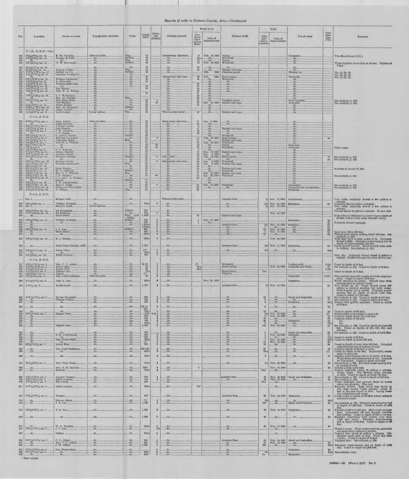
Records of wells in Graham County, Ariz. Continued
No.
206 207 208 209
210 211 212 213 214 215 216 217 218 219 220 221 222 223 224 225 226 227 228 229
230 231 232 233 234 235 236 237 238 239 240 241 242 243 244 245 24B 247 248 249 250 251 252 253 254 255 256 257 258 259
260 261
262 263 264
265 266 267 268 269 270 271
272
273
274275 276
277278 279 280 281 282
283
284
285 286 287
288
289 290 291 292 293 294 295
296 297 298 299 300 301
302 303
304
305
306 307
308 309 310
311
312
313 314
315
316
317318
319
320 321 322
323 324 325
Location
T. 7 S., R. S6 E. Con.
SEJ^SWJi sec. 14 ...NEJ^SEM sec. 15 .do SWJ4SEM sec. 15 __
SEJ^NWM sec. 15 SEi^SEMsec. 16 NWMNWM sec. 17 NE&NWJi sec. 17~
SWJ^NWJ-i sec. 21. __ NEJ^SEMsec. 21...... SEJ£SWi£ sec. 22 SWJiSW}^ sec. 23 NEiiNEM sec. 23 SEJ^NWM sec. 24 ...
NWJiNEJ-i sec. 24 ..
NE^NEMsec. 24.. ...
SEJ^NEM sec. 25 ...NWj^NWM sec. 26. _ NWMNEJi sec. 28..... NEJ^SWM sec. 31
T. 7 S., R. £7 E.
NW^NWJ4 sec. 1 -do . .. ...SWJiNWJ^sec. 2 __ .NEJ^SWM sec. 2... ....SWJ^SWK sec. 2 ....
SWi^SEM sec. 3 SW^NWM sec. 3- __ .SW&SEii sec. 4 NE^SWM sec. 7 ..SEJ-iNEii sec. 8. ......8Wiisee.8 SWJiSEi^ sec. 9 NEi^NWii sec. 9- _ .NWMNEM sec. 10-; SW&S\Vi£ sec. 10. ___ ..do.. .. __ ..NWMNW^sec. 15 NE^NE^' sec. 16. ....SEJ^NEM sec. 16 ...SWi^NE^sec. 16. ....SE^SWMsec. 17 NEiiNE^ sec. 18. __SWi^NEiisec. 19. _ .SWMNWii sec. 19. .... ..do...: ....NEi^SEMsec. 19......NE^NEM sec. 20 NW^NWM sec. 21. ... SWMNWM sec. 30
T. 8 S., R. SB E.
SEJ#8EJ£ see. 1 ~
SEMNWM sec. 11 NWi^NEM sec. 12..... - .do ..
NEMNEM sec. 12 .... do _ -do -do. __ ....SEJ^NEM sec. 12
... ..do ..... ... . -do .... ...
SW&NEM sec. 12.-...
_ ..do . _ .
NE^SEKsec. 12 . do - - SEMSEJ4 sec. 12
T. 8 S., R. $6 E.
SW!4NWM sec. 5... ... NWMSWM sec. 5- _ .SW&SWJi sec 5NE«4NE>4 sec. 6 ....SENSE'4 sec. 6. ...SEV^SE^sec. 6 ___ ..
SWJiSWM sec. 6
NWJ^ sec 6
NWJ^NEJi sec. 7. _
.. do.. ... ... ....
do-.. ........
. do. -. _ . ......SW^NE^sec. 7... ... do. ..do.. ... ........ do.. ... ..... .- do.. ... ..... ........ .do.- ... ... ... ...
do... .... do.... ... .......__ do... ___ -__ .do. _ ..... .-._.__... do. ...SE&NEJi sec. 7 .
do. __ .do. _ . ___ . __ _
. .do.. ...............
NEJ^SEJi sec. 7 ___ -
.. do-.., ... - do.....
NEJ^SW^sec. 7 ...SEi^SWiisec. 7- ...SWV^SWMsec. 7......
NWViSAVJi sec. 7 .
NEMNWM sec. 7 .
do.... .... ... ... .do--
SEJ^NWJi sec. 7... ...
do.... ........
- do.,. . __ . __ ,SWViNWVi sec. 7..
_ ..do.... ____ . ....
NWMNV/M sec. 7 do..-. . __ do.- __ .
NWi^NEM sec. 8~. ...SWJ^NEVi sec. 8
Owner or name
E. M. Claridge ... ......
do N. W. Stevenson _ .
Saflord Ice Co _______
E. Ellsworth ________
do __ . _ . _
I. C. Wiliiamson. __Mrs. M. Padilla ____ -
Ted Phillips, __ ... .. ....
Mrs. M. Kempton Albert Morris _____ ...
Jesus Abieto. _____ ...
3. W. Grijalva- ______
G. and D. Curtis _ _ ..
Mrs. E. L. Tidwell ____ .do . .... .... do- S. N. Holman _
do __ Ammon Curtis.- -
W. H. Gillespie- _ - __ - Mrs. E. L. Tidwell __ ...3. N. Mattice
School - __ - - ...P. H. Freudenthal _ - __Etta O. Deller .. ...
N. Wilson. _ .... .
William Waddell ......
Ed Erickson .............
do .... __ __ ..
3. A. Lee- __ ..-...
.do
Elam Olsen (Stailey well).
do ... . _
Mrs. C. L. Allred. __
John A. Lee ___ ... ..
do. ___ . ____ . _
do .. __ . _
..... do.. ... .... ... ....Sargent Bros __.___
do- _ -
. do.. .... .....
......do. _ . __ . .........
_ do..... ...............
do- .... ___ .
J. A. Lee __________
F. L. Lee ...............
.... .do. .. .......
W. A. Woolsey .. ...3. C. Lee.. ..... ...
C.L. Allred.... .......... Mrs. C. L. Allred ____ . J. M. Allred.-
__ do__-___ _____ _ ___ ..do...... _ . _ ..-.-do..... ___ ..... ....
Topographic situation
.... do. . . __ _ do - do ... ... ...
..... do... .... .... ... .... __ do _____ -do. ... ... do ..do .... ... ... do ...... ...-...do . do ... ... . do ... do ..... do ... - do -do... .... ... do do .... do _do .... ...... ..do ..... do Lower terrace _______ ..
Alluvial plain . ........ . _ _do __ . __ . __ do .... . do ...... ... ... do do .... ... -do .... ... .... do __ . __ . do do .... .... . do- ___ .... __ do. _ - __- do - do._ ........ do. ___ . ___ do- __ do.- __ .... ... ......do. __ . __ . ___ do __ __ do- do.. ...... ..... do.. .... ..do- do.. ___ - _ .do.. __ . _ do. _ .. do.- ..... __ _ . do. _______ do . -.-do--
. __ do... _______ . _ ...
do __
- _ .do. __ . ___ . ___ ........ do ... .... ... ... -do... ... .... .....
. _ .do.... _ . . _ ... __ . do . do ___ . .. do ..... .... - do ... -do. ..... . do _ .... _ - __ -
do ... .....
do. ...... ...
. .do ..... ..... ... do ... ...._ _ .do.. ______ - ___ -
.do __ do . ..... - do ________ do _.do
- .do.
do. __ .........
do. _ ... ....... ..... .do. ... .... .... .... ... do. _
do. __ ....... ___ ....
. do. __ ...... ........... .do- ....... ...... ... . __ do ____________ .__ do. ___________ - do. _ .................. do. __ ..... ...... ...__ do. _______ . ___ .
..... do. ...... ... ... ..... do. ... __ do. ___ .. ____ . __ . do _ . do. ..... .... ...... .do. ... ...... ..... ...
do. __ ...... __ ....... __ do. ___________ .
.... .do. ..... .... ... .... .....
- do ...... ..... ....
..do... .... .... ... ..... ..._ -do... __ .............
..... do..- .... ... do...- ...... ._. do... ...
do....
_ do....- _____ . __
__ .do _____ .... __ - do.. .... .... .....
.... .do-.. ...
- do
..do... ..... ........ do........ ....... .......
do... ... ........
do.. ....... ........ .do.... ...... .... .... . _ .do.... ______ . .....
- __ do. ..do -_ -do.... ...... ...
Type
Dug.. .......Drilled Dug- ..Drilled. __ .
do Dut;_. .......Drilled do .... -do... ... ...... do .... do -do .... -do
Dug- _____ do _ -do -do ....Drilled ... do ...Dug .........
do .. -do do -do ... - do .... -do ...Drilled. ..... -do .Dug- .. __ do ....... do do. _ - do. _ - -do . do-Drilled do do Dug. _ . . .do do. _ -Drilled.. _ .DUR. .... do. _ - do. _ ..Drilled do-_ do. _ .. do- .Dug. __ ...
. .do .
- do
Drilled -do Dug and
drilled. Drilled. . . . do ____ do .-
Drilled . __ do do
do
.do.
do... .... .do do
-do... ..... do .... -do... - do .. do .....do......
....-do......
. do.
__ do. __ . -do ..... do... ...
do. .....
do ..... do... do ...... do... -do. . do... ..... do. _ -
do do. do do do. _ - do
do do. _
..... do. .
do
.... -do.. do..
- do... do... do...
..... do.. .
..... do... ...
do -do
..... do .
.....do...
-do -do
. do.
do...... do.... ..... do......
... -do
... - do... . do...
Depth (feet)
22 40 15 42
42 16 40
40 40 50
50 22
33
40 18 20 50 45 48
18 31 10 17 15 15 42 25 17 15 16 30 10 32 27 60 45 57 43 42 39 47 12 26
75 75 85 75 22
700±
800 700
1, 400?
600 600
1,000± l,000db
900 800 800±
500±
1,313
(?) 500± 550
60-70 60 60 75±
(?) 30
400±
1,700
830 250 250
250 or 300 700±
<250 500 700 700 400±
1,080
270 300 350 760± (?) 825
800-900 800+
500+
260±
COO? 500±
800 950 400
600±
900
(?) 1,130
1,200
1,300
980±
600±
900 860
1,050
500? 500?
Diam eter
(inches)
4 36
4
84 36
4
6
48
6
4
4
4 4 4 4 6 6 4
4
6 4 3
4 4 4 4 6 4
4
4
4 4 3
3
3 3 or 4
4 4 4 3 4
2 3 6 4 6
4 3
4
4
4 4
4 4
4 4
6
8
42M
4
4 8 4
4 4 4
Geologic horizon
Quaternary alluvium.. . . do __ .....-. .. do .... ... -do .... ... ...
do ........ ....... -do ... ..... do-. ....
Quaternary alluvium _ __ .do ___ _ do do ____ .. ... .do do do .... do- .... ......_- do do ....... do .... .... do ..... ... .... . .do . .... do . _ ... __ .. do.... . . ....Pliocene lake beds? ...
Quaternary alluvium _ . .. do __ .... - do . __ do do _ ..do .... do . ..... ...... do ..... do .... .... ..... ..do ... .do-.... .... ..... _ .do. _____ ... __ . do do. .. do. ___ . _ . ...Lake beds? ________ . do.. Quaternary alluvium. _. _ do _____ .. do-_ ...... ....- -do-._ _ __ . -do.. ........ do. .... ... do. __ .... . .... do __ .... . ___ do. .... .... ..... -do...... .... .... do ........__ do. __ ... ___ .... do. ...
Pliocene lake beds.
.do .... ... .... ... do.... __ .......
-do ..... ........... -do ....... do ...... ...
-....do ........ __ do .....__..- __ do __ .. .... .do . _ . do ....... - do ... ....__ .do _________
.do- ______ ......
-do ....
. _ .do _______ ...
. _ .do... ____ ... _ .. _ do
. .do ........ ...._ ..do. __ . _ . ......... ..do _ do -.. do . _ ... _ ... ___ do... _ . _____ .
__ do. __________
do. _ .
. _ .do......... _ . _ ..__ .do. ____ . ........._ __ do. _______ . ...
... -do... ......
. do.... __ ..........
.....do..... __ .........__ do- ____________ do. ____ . ..............do. ___ ...... ..... ...... do ... .......... .do. ......... .
..... do.. .............. do..-. .... .........-.-.. do. .... ... ....__ do. ______ ... ... do....... ... ........__ .do.. ..... ....
..... do.. ................ do... __ .
..... do... ........
..... do.... .... . .......
-do.-. .. .....__ do-.. ______ ..
. __ do __________ .do. ________ .. .do... .... ...... .....
. __ do ... __ .......
do.... ...... .....
- do , ...... do. _ ........ ......
. __ do... ...............
do ...... ... ...
..... do..... ............. ..do-- ...... .....
do __ ....
.do. .......... do. _________ ...... do.... ..... ....
do.-- ... .... .. do-.. ........
.. _ do. ____ ..... _ .
Water level
Dis tance below surface (feet)
8 38± 1340
40 13
40 40
303516 192120 22 16 16 18
33
17 30 8
17 14 14
17 15 14 12 28 9
21 26 40 15 30 42 40 38 14 11 24 20
55 60 20
20
1 1
(?)25± 20±
2
30?
Date of measurement
Feb. 16,1934 do ... - do Feb. 10,1934
-do ... do Feb. 1934
Feb. 1934 do do- _ - -do do do ... .do.... ........ . do ....__ .do ... do do -Jan. 25,1934 do -do . do .... do
Jan. 4,1934 -do . do -do.... .... do do .....- do Dec. 12,1933
_ _ do _ ...Dec. 15,1933 do do . -do. Dec. 12,1933 Jan. 4, 1934 Dee. 19,1933
- __ do. ...Jan. 3, 1934 Jan. 4, 1934 -do.. . -do. do.. ...Dec. 15, ]933 Jan. 22,1934
. _ .do ____ do. Feb. 13,1934 do- _ ...
Nov. 16, 1933 do _
Nov. 16. 1933
Method of lift
. do ...............
do .... _do -do .... .... _____- do ..... do ._ _.
do. .... -do .... ..... ...
__ do. do- ...... ... ... ... ...
Windmill. __________ ..
Windmill ......_....
Windmill- . . do ____ . __ .... __ ..
do .... ... .... .....__ do- _____ ... .....
do ... do _ _ -do __ _________ - do ... .... .... ....
__ do ______ ....
Filled in
..... do.. ... .....
. _ .do ______ ... ........... do ___________ . ....
..... do.... .... .... .
. do. .
.. do.... ... ... ... .... ... do. _
do. ____ ... ______ .. __ do. . .._. - .
do. _ ...... __ ..........- _ do __________ .. ...... __ do. ___ . _______ do.. do. _ . ... .... . ..... do.......
, _ .do. ______ . _____ - do. _ ...
. __ do ______________
- do. .... ..... .... .
do... ..... .... .......
do-... ... ..... ........__ do __ . _____ . .... .
. do.-. __ .....
..... do.... ... .... ....
__ .do.... ________ . ..... -do.- . __ . __ .......
do.... ... .... . . do... ....... .... ....
do.... ... ... ...... ...._ ..do.... __ ... ______ .., _ do... ___ . ___ - ....
Yield
Rate (gal
lons a minute]
M
3W M
Vfy.1
62 3
13
2H
4#
Dry
y*
12 2 6
2
153J/2
3 50 30 2
140
1 5 5 7
67 70
20 65db
2
2±
Dry
38 20
Dry
34
2M 122
30
40
67
56 24
108
3Ji(3)
Date of measurement
Jan. 17,1934
Nov. 16, 1933 Jan. 17,1934
Nov. 16, 1933
Nov. 16,1933 do Nov. 15, 1933 Nov. 17, 1933 do
Nov. 16, 1933
Nov. 17,1933
..... do -
Nov. 18, 1933
Nov. 16, 1933
-do... . do. __ -..... do ....
..... do.
do Nov. 15, 1933 Nov. 14, 1933
do -do. Nov. 16, 1933
do-_ Nov. 15,1933 do.- _ .Nov. 14,1933 Nov. 13,1933 do
do do. _
- do. _
Nov. 15, 1933
Nov. 17, 1933 do
Nov. 18, 1933 Nov. 17, 1933 do..
-do
Nov. 16, 1933
__ do __ ........ do.
Nov. 15, 1933
-...do.. .
Nov. 17, 1933 . _ ..do.
- _ do ...
Nov. 16, 1933 Nov. 15, 1933 .do.
Use of water
do ..... do .... ... do ...
do do ________ . ...
.do .......... ....... ... do ... .... - _ -do ..... _.. . do . .....- do ........ . do do ..... ..... do ..... .... ..... do ________ .
do .... .... .... . do ...... .......... _do ........ ........ do .... ... ..... ...
..do .... ... .... ,do ...... . ...... -do . - do . do ... .... ... ... .do .... .... ... - do ... .... do .... ...... ... do __ do
do ___ . _____ . ..... do. .... ..... .. do- .... ... do. _ .... ..... . _ ..do __ . ________ - do... .... ... ..... do _ __ __ do-. ___ - do.. ....__ do. ___________ - do.. .... ... do. . .- do. _ .... .... _ ..... __ do. ____________ do.. _ __
. __ do _..__. ___.. do ____
-do ... ... .... ...... .
Domestic-
Irrigation-
- do. .
. .do. ...... .... . do. __ .... ...... .... .do- _ - .........
do. _ ...... - -
do. .....................- do.-. ____ ...... .do. _ __ ....
do- _ ... ..... .. _ do. _ . ______ . __ .
do.--.. .... .....
. __ do . . .........
- do ... ... .... .....
. _ _do.-.. _____ .........
.do . ..
. do - _ .
. __ do __________ . ....
Irrigation.... ....... ...
Tem pera ture (°F.)
66
78 68
86
70 65 87 85 90 90 86
84
88.4
Cold 67
Cold
Cold-
83
86 77 80H
80
84 (?)
78 86 84 76K 95
7677 75H 83H 85 84
87 (?)
77
76
56
91 93
85
80H 96
95
92
93
9196H
80 82H
Remarks
Two flows (8 and 22 ft.).
Three aquifers above that at 40 feet. Highest at 8 feet.
No. 15, fig. 32. No. 16, fig. 32. No. 17, fig. 32.
See analysis, p. 222. See analysis, p. 222.
Salty water.
See analysis, p. 222. See analysis, p. 222.
Aquifers at 14 and 47 feet.
See analysis, p. 222.
See analysis, p. 222 See analysis, p. 222
Two wells; originally flowed a few gallons a minute.
Formerly flowed rather copiously. Two wells; originally flowed a few gallons a
minute. Flowed about 10 gallons a minute. Is now dry.
Hole 3 feet in diameter has been dug to depth of 20 feet, where water seeps through casing.
Formerly flowed copiously.
Sand from 500 to 800 feet. Flowed sand during drilling below 500 feet. Bee
analysis, p. 222. Well may have a little water in it. Formerly
flowed a little. Principal water-bearing bed at depth of approximately 500 feet.
Never flowed heavily. Much trouble with sand in drilling. See analysis, p. 222.
Now dry. Originally flowed about 2 gallons a minute. Drilled through blue clay all the way.
Cased to depth of 60 feet. See analysis, p. 222. Cased to depth of 60 feet.
Cased to depth of 75 feet.
Was used for domestic supply of whole neighbor hood. Cased to depth of 30 feet.
Water standing at surface. Flowed very little because sand at bottom caved.
Was drilled for oil. Water flowed about 300 gallons a minute; scalding hot salty water. Well stopped up by debris. Principal water bearing bed at depth of about 1,600 feet. Cased to depth of 1,600 feet.
See analysis, p. 222. Cased to depth of 700 feet. See analysis, p. 222. Cased to depth of 20 feet. Present flow greatly depleted. Cased to depth
of 60 feet.
Cased to depth of 640 feet. Inaccessible; under water in reservoir. Cased to depth of less than 500 feet. Cased to depth of 700 feet.
Do. Do.
See analysis, p. 222. Cased to depth of about 400 feet. Flows at depths of 270, 675, 835, and 1040 feet.
See analysis, p. 222. Cased to depth of 1,040 feet.
Cased to depth of 20 feet. Cased to depth of about 760 feet.
Cased to depth of more than 800 feet. Principal water-bearing bed at bottom of well.
Cased to depth of 800 feet or more. Cased to depth of 800 feet. Inaccessible; under
water in reservoir. Highest water-bearing bed is at depth of 90 feet.
Water forms hard crust on top of soil. Analysis by University. Cased to depth of 18 feet.
See analysis, p. 222. Principal water-bearing bed. at bottom of well.
Flowed a little until 1930. Flowed originally about 50 gallons a minute.
Warm water. Was flowing fairly strongly in 1915. Cased to depth of about 500 feet.
See analysis, p. 222. Cased to depth of 800 feet. See analysis, p. 222. Water originally shot upward about 40 inches
above top of casing. Was cool. Formerly flowed. After water was struck in
this Well several "mud springs" about 75 feet to the east ceased to flow. Spring water was sulphurous and warm.
6-inch casing to depth of 200 feet; 4-inch casing to unknown depth.
See analysis, p. 222. Principal water-bearing bed at depth of 1,050 feet. Cased to depth of 1,000 feet.
Flowed at 860 and 600 feet. Had much stronger flow. Lowermost 100 feet through boulders and pebbles. Cased to depth of 600 or 700 feet.
Hardpan alternating with pebbly sand from 1,000 feet down. Principal water-bearing bed at depth of 860 feet. Cased to depth of 700 feet.
Water is warm. Flows under reservoir, probably not more than 5 gallons a minute.
Original flow about 40 gallons a minute. Dis charged much sand at first. Went dry after 5 years. Cased to depth of 20 feet.
Depleted flow. See analysis, p. 222.
Principal water-bearing bed at depth of 1,040 feet. Cased to depth of 1,040 feet.
Bad sulphur taste.
3 Slow trickle.
149555 38 (Face p. 222) No. 3

Records of wells in Graham County, Ariz. Continued
No.
326 327 328 329 330 331
332
333
334 335 336
337 338
339 340 341 342 343 344 345 346 347 348 349 350 351 352 353 354 355
356 357
358 359
360 361
362
363 364 365 366 367 368 369 370
371 372 373 374 375 376 377 378 379 380 381 382 383 384 385 386 387 388 389 390 391 392 393 394 395 396 397 398 399 400 401 402 403 404 405 406 407 408 409 410 411
412
413 414 415 416
417
418 419
420
421422 423 424 425
126
427 428 429 430 431 432
433
434 435
Location
T. 8 S., -R. 06 E Con.
NEMSEJi sec. 8. __ ...__ .do .. ___ - _ -.. do do ..... ..... -NWMSEJ^sec. 8. .NEJiSWJi sec. 8 .
NWMSWM sec. 8
do ..... ...
SWMNWM sec. 8 do ..... .. _ do. _____ -
.....do . __ ..........SEJ,NWM sec. 8 .
SEM sec. 9 q WlV COP O
SE^SWJ,sec. 16 .... . do ... ... ... ..... - do - . _ -SWMSWM sec. 16. ..... do. ... ... ... - do ...... ...SWMNWM sec. 16 ..... do ... ... ..... .do....... ..........SWMNEM sec. 17 _ . NEMSEM sec. 17 ..... do ... ...... .... _do __ ... _ ..SEMNEM sec. 18
..... do .... ... ... ... .SWMNE^ sec. 18 ___
.... . do ....... ....... -
. _ .do ___ . _ - __ -
do. ...... ____ ..SEMSEM sec. 18- _ -
do __
NEMSEMsec.20
.....do __ .... __ -SWMNEJi sec. 20...... ..do ... ... NWMNEM sec. 20 _ .. do __ . .... .NWJ^NWM sec. 21..
.....do.... ...........SWJ.NWM sec. 21.....SWMNWM sec. 2] _____SEMSEM sec. 28. ______SWMSEJi sec. 28 ______SWMSWJ, sec. 28 ______NEJ,NWM sec. 28 __ SWMSEJ,sec.29._ ____NEMNEJi sec. 31 SEJ,NEJi sec. 31. _____NEMSEM sec. 31. _____SEMSEM sec. 31 .....__NEMNEM sec. 32 SEMNEMsec. 32.. __SWMNEM sec. 32
NWMNEJi sec. 32. __NWMSEJ, sec. 32.. ____ do.. ___________ do _______ .SWJ,SEJ4sec.32._ .___
. __ do.. __ . _____ -do .._ ______NEMSWM sec. 32 SEJ,SWMsec. 32.. do SWMSWM sec. 32. .....NWMSWM sec. 32 _.___ ._ do...-. ...... ..do. __ -SWJ,NEJ£ sec. 33.
doSWJiSEJI sec. 33. _ -NEJiSWJi sec. 33 .do ... ... ... - .do .... ... do SEMSWMsec.33. .SWMSWM sec. 33 ......NWJ.NWM sec. 34
.do. ___ ...
T. 8 S., R. 27 E.
Sec 6NEJ.NEM sec. 7 NEJiNEJi sec. 26
T. 8 S., R. 98 E.
SWJ,SWJ, sec. 22
T. 9 S., R. S6 E.
NWJ,NEJ, sec. 5. _ _. NEKNWM sec. 5. __ .
NWJ.NWJ, sec. 6__...
T. 6 S., R. _7 E.
Sec. 1_. ..-. __ .Sec. 13. __ . _____Sec 23Sec 24
T. 9 S., R. S8 E.
NEJ,SEJ,sec.31_
T. 10 S., R. g8 E.
SEM sec. 7 _______Sec. 21 ._._.._ .....
... ..do ...... .... ...Sec. 25.. ____ . __ .SEMSEM sec. 28
T. 10 S., R. t9 E.
Sec. 21...... _ . ___ .
T. 11 S.. R. «8 E.
SEJ,NE}£ sec. 21. __ NWMNEM sec. 28 .._._
Owner or name
__ do..... ________ .
. do- ___ - -Sedina
Mrs. C. B. Yett - ..
(?). (?).
J. W. Lively ___ __.___..
W. D. Roper- .
Will Smith ______ Will Crum ________ - do. _____ _.__.. . _ .do _____
. __ do. _________ - do Adeline Jennings
do
C. L. Jennings ..__.____.
.do ... ... ... -Tom Edwards
__ do ................. .... do _____ _ -
.....do ______ - __ .
..... do ....
do __ . ... -
do _____
do __ ...
A. Stepp _
do. _ . _______
Ray Clufl ______ __
do . __ . __
TT&wlr
do
__ do __________
__ do _________________. __ do ________
. __ do. _________
. __ do ___ . _________
. _ do _________________M. Jewell -.. ._ _-_ J TT Porrv
HawkMyron Allred ....___.... . do _ . ..._..... do. ____ . __ . __ .
- do
do . _ .do _ . __ . ___ -
do
J. A. B. Jones _ .____...
J TT "Pom?
.....do _ ..... _____ -
William Ellsworth _____ .
Bailey well ________
Final Oil Co. _______
Whitlock No. 1- ._........
Whitlock No. 2 ______
__ do ___________
Topographic situation
...__ do ... .... ...
. __ do ___________
. __ do. __________ ...
...do _ ........
.....do _ . _____ __ -
. __ do ___________ -
..... do..........
, do ___________-__-. do _..___ ______ -
do _ ______ do .. . ..... do _ - -
do _ ___..._____ _
..... do... ... . .... .... do ______ - ____ - do ...
do . _ .do ____________ .do __ . __ ..... .... ...... _ .do . ________ ..
do _ ___ .......... do _ ..... .._..
.do _ .._...... - ..do _ . - ... -
..... do .. .
.....do _ .... _____ _._..
.do ... . -. _ .do ____ - ___ .. -
do- .
. do .... __._._.
. .do __ .. ... do __ .____ __ .... - do __ . ...
do _. _ _ __ do ____________
do . _ ___.do ______ _______do ____________
.. do ____________do .do . .. __ ______
. __ do ____________do _ ______do _____ . __-_do ______ ____
__ do __________do . . ____do _ __ _ ______
. __ do .. _______ _ do ____________
__ do ____________do ._
__ do ______________ do _____ ___. _ do _____________
.... .do ..____ ______
. __ do _____________
. _ .do. _..__.__ ._._...
.... .do .... ..... ... __ do- _ - ____ . __ .do- ___ _.-__.____. . . .do ... ... ... .... do _ . ____ ..... _ ._ _ .do. __ ...__... ___ .do __ do . .do ..... . __ do ___ . ____ . ___ - .. do .... ... . _ .do _________ . __ . .do .. .._-- _____
do
. __ do. __________ ...
.do. __ - do
.....do ________ . __ ..
.. do ...... ... .
. __ do ___ __._._
. _ .do.... _ ___ ___ . _____
.. do _ . _____ . ______ do.. ___ ..._._. _______ do.. ___ .... ___________. do _____ ______ do .. __ . __
do __________
.. do ___________________ .do _______ . ____ do ____________ do . _____ .__ do -___-_____._____-_ do.. ________ . __ .
do......... _........._
__ .do ______________ _ do _ . _ ______ ____ ______
Type
Drilled . . ..do ... do- .___.. __ do ._._.. do ...... do ....
_____ do
do. __ ._ ..do ___ -_____ do ....
.__.. do .
. __ do .____..
do . do ..... do ... do . __ do- __ . do __ ........ do ... do. __ .. _ .do ___ - do do .....do ___ .. _ .do ___ . - do ... . _ .do __ ... do-Dug- .
Drilled .... .do -
, _ .do ___ - do
__ do _ . __ .do ___ -
do __ ...
do __ .... _ .do __ .... _ .do ___ -
Drilled ___ . do __ __ .do ___ -.....do _ ...
. __ do _ ...
__ do _____ do. . .__. __ do _ ..... do._ .. __ do __ do. ______. __ do ______
_ __ do . __ do __ do ___. __ do
. __ do __
. __ do
. __ do.
. __ do
. __ do __
. __ do . .
. _ .do- __
..... do... .... do do do . do ... .. __ do __ -. __ do __ - do ..... _ .do __ -__ do __ .- do ..... _ .do ___ -. _ .do. __ -. __ do -
.-_-_ do __~
do - do -. __ do __ ., -do -
..... do
_ _ .do __ ..... ..do
... ..do ....
do __ - do . __ do ___... ..do . ..do ...
.....do.. __ .
.___- do __ .do __ do- __ . do do __ do __ ..
__ .do _ _
__ -do __ .._ ..do
Depth (feet)
8400± (?) (?) (?)
500 or 600 500
800± 800± 450±
2500±
620 470 80
620 800 763 500 600 380 380 480 600 500
. 380
40
400 700±
(?) 700±
800 700
700
415 100 500
300
700 580 610 800 540 280
500
500? 40
750
300
400
340 400 400 400 500
------
360 740 740
400 400+ 500 600
900
80
68 90
120 60
720
900
80 58 65 60
765
150
80 250 140
1,555 200
1,925
525
680
Diam eter
(inches)
3
4 4
6
4
6 6 4
6 3
4
48
4 4
4 4
4 8
4 2^_ 3
4
6
4
3fc2
6
_______
._.___
3
4
4
4
3
8M
8
8
Geologic horizon
__ do __ _____. _. do .. ___ _.___. __ do .... __ do..... do _ . __ .__.
.....do ..... ____
. __ do. _________
do _____ . __ do .___. do... ... ..
. do . __ .____.
.. do...... _____ -
do ... ___ do. ___ . ________ do __ . _______ .. __ do- __ __________. __ do ______..._....- do __ _._ .. .do . __ do __ . ..___.... . __ do _ . ..__.___ ... do ____ . do . _ ...... do. ________
.do _.... do __ . . .._ ..__. __ do ._________ ... _ .do __ _______. ___
... -do _ . . -....do ____ ..... __ . _
. .do __ .__. . . .do __ .... __ __.._..
__ .do ____________ .do
do
.... do _ _________ do ____________ do __ _-_-.-._-____., _ do. _
. do _ .
__ do. ___ __
. _ .do _ .... ___ . __
._ do- . ______ do.. __ ___________
dodo. . _____
_ do. ___ do ____________ do.... ______________
do.. _ do. _ _______ do ___________________. __ do..... _____________
do. do. ___ do. __ ____________
__ do- ___ do.. ___________ do __________ do __
do __ _ _ . __ do... _______________
. _ .do ..... ______
. _ .do ... ... do __ __ do _ . _______ .. do __ do __ _.._. do. .do ... .... . _.. do .... ... .... ...__ .do ______ . _ . do... ..... .... ....... do. __ . ______ . do ..... .do .... ... .do. __ - ______ ..... -do .... . -do ...
.do. __ _____ ........ do ..... - do ... do... _ -
__ .do _____ ...
. .do. _ .do...... ____ , _ .
_ do
.. do... __ .... ___ .
.....do ______ . _____ _ do ________ ... do ____ . ____ ......do.... ____ . __ .
-_ do._ __ . ____________
do... __ .... ___ , .-do.. ___ . __________. __ do. __________________ do ____ ... ___ ..
do.. __ . __ ........
....-do _
_...do.__ ___ . ___ ... do.__.___ __._
Water level
Dis tance below surface (feet)
18
40
38
20 12
(?)
ffl
30
10
30
_______
_____.
18
10
40
70
125.
60
150
Date of measurement
Jan. 18,1934
Jan. 6, 1934
do do __ . __ do __Jan. 7, 1934 __ do _____Jan. 6, 1934 Jan. 7, 1934__ do ____Jan. 6, 1934 __ do ______ do_. _____. __ do ______. __ do __ .__ do ______ .do __Feb. 2, 1934 __ do ______
do. __ do _ .
do -. __ do __
do .do
__ do .Jan. 6, 1934 Jan. 7, 1934 Jan. 6, 1934
-do ..... ..... do _._-. _ do Jan. 7, 1934
. _ .do __ do ___ .__ .do __ do __ .... .do. -do Nov. 13, 1933 Jan. 7, 1934 . do .....
do
Feb. 20,1934
do. ...__ do ____
__ .do ________
Method of lift
do __ ______________ _____. __ do. _____________ do ________________ do ... . . _____________ do __ . ____ ________
Hand pump _________
.do ___ ___._ -
.. _ do _ .
- do ____ _ __ _. __ do do _____________ -- do ___ , __ do _ . _ .do __________ . . do __ . ____ . __ do __ ______ . _ .do __ . __________ -_ do _
do _ do ___
do _ . -do __ __ do _ __________
__ do _____________do . _ _ ____
__ do _______________ do _____________- _ do
do _ _ _ _ _. _______ do ________ _____
do . _ _ _Pump.,,. t , ,
Artesian flow _ ___________do _ ____________
- __ do ______ ________
Artesian flow __ _ _____ _ do _ ________ do . . __ do ____________ do __ ____________ do __ _ __ ______
dodo
Windmill _ _ __.,_ __ __
. __ do. __________ do .do __ ..do ___ ..... _____ .... .do __ - _________
. __ do ______ . ___ - __ - .do ..... -...do ____ . __ - _Windmill. __ - _____
Windmill ________ ...... .do _____ do
.....do __ . __ .... __ . _
. __ do........... ___ . ______
.. do-. ____ .... .
Windmill ___________ .do ______ ... _ ___
Windmill...... __ . _____ .
__ do... ___________. do ____ ... . __ ____.
Windmill ___________ ..
Windmill.... __ ....... __ .
__ .do.. __________ _____ do _____________
Yield
Rate (gal-
lonsa minute)
(») 6 7J_
12J. 9
60 to 100
W1940 1J_
Dry
1K
y* y* y*17 7
127
10
22
Dry
25 4
46
12 15 7H
10 1
15 32 5 tt
M H
3KXX J.
27 M
14 80
1
10
15 15 30 12 9
W 8^_
14 17
H
H
20 -f-
Dateof measurement
Nov. 17, 1933
Nov. 14, 1933 do .do
__ do __ _-
Nov. 18, 1933
-do .Nov. 17,1933
do -.....do __
do __ _Nov. 18, 1933
Nov. 17,1933
- - -
Jan. 7,1934 ..... do. ______
.....do. ______
do __ .Feb. 20,1934 __ do ______ do _______
Feb. 2, 1934
. _ .do.. __ .
. _ -do _ .. -do .Nov. 7,1933 __ .do .. ._... do........
-do
Use of water
.. do.. __ -
. do .
. do ________ _____
. _ .do. _______
.do . -. .do __ . ___ ... ___._.
. __ do. ______ ________
do _. - do __ . - ___--. _ .do ____ _ _____ do __ .
- do __ . -
do __ - __ - __ do _ _- _ -__ ___ _
do _ _ __ _ -
do ______
Domestic and irrigation
Domestic and irrigation ____ Stock ___________Domestic _ _ __. __ Stock _______ __________Domestic _ _ _ . _ . _ do __ __ ____________
Abandoned _ __ ____________
Irrigation ____ __ do. _________
do
. _ .do ____ ____ __ -do.
do ______ -. _ -do ___ __ .do __ . -
- do -
Stock _______ _ .__
__. .do. ___ _ .
- do ... ____
_ do _ _____ _ ._._.. _
Stock ___________ __ .do ______________ do ____________
Stock ____________
Stock... ____ . ___ do _________ -. __ do. ___________
do- __ __ _ __________
Tem pera ture (°F.)
76H 78H 77 76J_ 78J_
(?)
70H
85 8477
82
71
79 78 81 75
87
70
93
(?)
76 71 83
78 87 87
68
82 91 83 85
88 77
80 90~~
85 91
82
86
87 82 90 91 91 77
91 91 92 79
85
97
105
Remarks
See analysis, p. 222. Sulphurous taste.
Inaccessible; in middle of deep reservoir.
See analysis, p. 222. Cased to depth of 20 feet.
Flowed about 50 gallons a minute when drilled. Warm water. Cased to depth of 60 feet.
Cased to depth of about 800 feet. Do.
Somewhat bitter taste. Cased to depth of about 450 feet.
Well bungled in drilling. Now filled with debris. Flowed about 5 gallons a minute. Cased to
depth of 20 feet.
Cased to depth of 80 feet. Formerly flowed. Dry. Inaccessible.
Inaccessible; in reservoir. Do.
Formerly yielded good drinking water. Now contaminated by water from irrigation.
See analysis, p. 222. Cased to depth of 400 feet. Flowed strongly when drilled. Warm water.
Cased to depth of 20 feet. See analysis, p. 222. Cased to depth of 900 feet. Flowed strongly when drilled. Warm water.
Cased to depth of 20 feet. Do.
Originally flowed about 6 gallons a minute. Cased to depth of 20 feet.
Was sulphurous and salty. Originally flowed about 15 gallons a minute of warm water.
Struck water at depth of 80 feet.
Aquifers at depths of 300 feet and 90 feet.
2 wells. Small flow. Inaccessible; in reservoir-
Cased to depth of 660 feet. Inaccessible; in reservoir
No aquifers above 500 feet.
Formerly flowed,
Cased to depth of 160 feet.
See analysis, p. 222. Cased to depth of 400 feet. Inaccessible; under water.
Do.
Inaccessible; in reservoir.
Old deep well.
See analysis, p. 222. Inaccessible; in reservoir. Principal water-bearing bed less than 100 feet
deep. No water; well not finished.
Salty water.
Aquifers at 40, 80, and 120 feet.
Subartesian aquifer at 720 feet. No aquifers above this bed. Cased to depth of 700 feet.
No water below 500 feet. Inaccessible; in reservoir. Flows perhaps 10
gallons a minute.
Salty water. Do.
Only one aquifer encountered: depth 144 feet, (See p. 202.)
See analysis, p. 222. (See p. 214.) Cattle usually avoid this water. See analysis, p. 222. Water is shut off by valve.
Pressure at valve reported to be 80 pounds per square inch. (See p. 214.)
Core drilled. Basalt from 425 feet to bottom. (See pi. 53, _4.) Water-bearing bed at depth of 380 feet.
Domestic supply for several families.
* Slow trickle. < Filled with debris.
149555 38 (Face p. 222) No. 4