geology and mineral deposits of the mount morrison quadrangle
TRANSCRIPT
.-\ ~"'!'~ '~. ~~/ . -~~ ., "' ,, :-, .·, ,v .. ~"""~~s
r-:·•. ,. ,' h·b~ ... U. s. ,;-;,.t : ~,' J·. l c~"tor West~m "· ·- · ' t~ ii ~· :; ',), ' . ~- . l Sp~\~~n~~ \:~p;,.,\~lJ~,~n \.r~~~
Geology and Mineral
Deposits of the Mount
Morrison Quadrangle
Sierra Nevada, California
GEOLOGICAL SURVEY PROFESSIONAL PAPER 385
Prepared in .cooperation with the State of California, Department of Conservation and Geology, Division of Mines

Geology and Mineral
DepOsits of the Mount
Morrison Quadrangle
Sierra Nevada, California By C. DEAN RINEHART and DONALD C. ROSS
With a section on A GRAVITY STUDY OF LONG VALI~EY
By L. C. PAKISER
GEOLOGICAL SURVEY PROFESSIONAL PAPER 385
Prepared in cooperation with the State of California, Department of Conservation and Geology, Division of Mines
UNITED STATES GOVERNMENT PRINTING OFFICE, WASHINGTON : 1964

,. •,1
\ '
UNITED STATES DEPARTMENT OF THE INTERIOR
STEWART L. UDALL, Secretary
GEOLOGICAL SURVEY
Thomas B. Nolan, Director
The U.S. Geological Survey Library has cataloged this publication as follows :
Rinehart, Charles Dean, 1922--
Geology and mineral deposits of the Mount Morrison quadrangle, Sierra Nevada, California, by C. Dean Rinehart and Donald C. Ross. With a section on A gravity study of Long Valley, by L. c~ Pakiser. Washington, U.S. Govt. Print. Off., 1963.
v, 106 p. illus., maps (part cot) diagrs., tables. 29 em. (U.S. Geological Survey. Professional paper 385)
Part of i~ustrati~~ .m~~~r fold. in pocket.
Prepared in cooperation with the State of California,-Department of Natural Resources, Division of Mines.
(Continued on next card) · ·
Rinehart, Charles Dean, 1922-- Geology and mineral deposits of the Mount Morrison quadrangle, Sierra Nevada, California. · 1963. (Card 2)
Bibliography : p. 102-104.
1. Geology-California-Mount Morriso~ quadrangle. 2. Mines and mineral resources-California-Mount Morrison quadrangle. I. Ross, Donald Clarence, 1924-, joint author. II. Pakiser, Louis Charles, 1919-. III. California. Division of Mines. IV. Title: Mount Morrison quadrangle, Sierra Nevada, California. (Series)
For sale by the Superintendent of Documents, U.S. Government Printing Office Washington, D.C., 20402
i

CONTENTS
Abstract-------------------------------------- 7 ----
Introduction _________________ ~---------------------Location, accessibility, and culture _______________ _ Topography and drainage _______________________ _ Climate and vegetation _________________________ _ Previous work _________________________________ _
Present investigation ___________________________ _ Acknowledgments _________ ~ ____________________ _
Geologic setting ___________________________________ _
Metasedimentary rocks of Paleozoic age ______________ _ ~omenclature _________________________________ _ Metamorphism ________________________________ _
PetrographY------------------------------------Siliceous hornfels ___ ~ ______________________ _
Field description _______________________ _ Microscopic description _________________ _
Siliceous calc-hornfels _____________ -.- _______ _ Field description _______________________ _ Microscopic description _________________ _
Meta chert~ .: _______________ · _______________ _ Field description _______________________ _ Microscopic description _________________ :..
Pelitic hornfels and slate ____________________ _ Field description _______________________ _ Microscopic description _________________ _
Sandstone ________________________________ _
Field description _______________________ _ Microscopic description _________________ _
Marble ___________________________________ _
StratigraphY-----------------------------------Formations of the McGee Mountain block ____ _
Hilton Creek marble ________________ ~ __ _ Siliceous hornfels ______________ ~ _______ _ Siliceous hornfels and marble ____________ _ Slate and marble _______ . ________________ _ Slate _________________________________ _
Sandstone ____________________________ _
Formations of the Convict Lake block ________ _ Buzztail Spring formation _______________ _ Mount Aggie formation _________________ _
Convict Lake formation ____ ..;,_-.- ______ -: __
Lower siliceous hornfels member _____ _ Upper siliceous calc-hornfels member __ Fossils and age ____________________ _
Mount Morrison sandstone _____________ _
Sandstone and hornfels .of Sevehah Cliff (informal group) _____________________ _
Formations of the Bloody Mountain block ____ _ B:t:ight Dot formation __________________ _ Mount Baldwin marble _________________ _
Fossils and age __________ ~ _________ _ Mildred Lake hornfels __________________ _ Lake Dorothy hornfels _________________ _ Bloody Mountain formation _____________ _
Fossils and age ____________________ _
Page 1 3 3 4 5 5 6 6 7 7 8 9 9
10 10 10 12 12 12 14 14 14 14 14 14 15 15 15 17 17 17 17 18 18 18 19 19 19 19 20 20 21 21 21 21
22 23
. 23
24 25 25 26 26 27
Page Metasedimentary rocks of Paleozoic age-Continued
Stratigraphy-Continued · Sandsto.ne at Big Spring Campground_________ 27 Relation between blocks_____________________ 28 Related rocks of pre-Pennsylvanian Paleozoic
age in the Great Basin ___ ·_______________ 28
Regional comparison of rocks of Pennsylvanian and Permian age _____ - - - -- - _------------- 30
Relation to the overlying metavolcanic rocks_______ 30 Meta volcanic rocks of Jurassic and Triassic(?) age_ _ _ _ _ _ 30
Volcanic breccia of Mammoth Rock ______ --_·______ 31 Latite of Arrowhead Lake ___________ ------------- 31
Petrography_______________________________ 32 Alteration· _________________________ ---_--_- 33 Origin ____________________________ -------..:_ 33
Quartz latite tuff of Skelton Lake ____ ---_--------- 34 Tuffaceous sedimentary rocks and marble of Duck
Lake---------------------------------------- 35 Volcanic series of Purple Lake-----------------:---· 36 Volcanic rock~ of Scoop Lake------~--------:----- 37 Stratigraphic and intrusive relations ______ -_---_-.__ 38 Age___________________________________________ 38
Diorite and related rocks of Mesozoic age _____ --------- 38 Intrusive granitic rocks of Cretaceous ·age______________ 40
Petrography ______________ -~___________________ 41
Presentation of modal data______________________ 42 Round Valley Peak granodiorite ___________ --_____ 44
Rock Creek mass_ _ _ _ _ _ _ _ _ _ _ _ _ _ _ _ _ _ _ _ _ _ _ _ _ _ _ 44 Lee· Lake mass _____________________ ------- _ 46
Relationship b~tween the Rock Creek and Lee Lake masses ____________________ ~ _ _ _ _ _ _ _ _ 4 7
Quartz monzonite and granite____________________ 4 7 Wheeler Crest quartz monzonite______________ 4 7 Quartz monzonite similar to the Cathedral Peak granite---~------------------------------ 48
Smaller felsic masses_ _ _ _ _ _ _ _ _ _ _ _ _ _ _ _ _ _ _ _ _ _ _ _ _ _ _ _ 49 Mode of emplacement ____________________ - ____ -_ 50
Sequence of intrusion-----------------------:----- 50 Age of the granitic rocks________________________ 51
Volcanic rocks of Cenozoic age_ _ _ _ _ _ _ _ _ _ _ _ _ _ _ _ _ _ _ _ _ _ _ 52 Field description________________________________ 52
· Volcanic rocks of the Mammoth embayment___ fi2 Pumice________________________________ 52 Andesite_______________________________ 52 Older rhyolite__________________________ 53 Quartz latite_ ______ _ ___ _ _ _ ___ _ _ _ _ _ _ _ _ _ _ 55 Younger rhyolite _________________ ~_____ 56
.Bishop tuff of ·Gilbert (1938) _ _ _ _ _ _ _ _ _ _ _ _ _ 56 Basalt ________________________ . __ .: _ _ _ _ _ _ 57
Olivine-bearing quartz latite_ _ _ _ _ _ _ _ _ _ _ _ _ 57 Volcanic rocks of the Sierra Nevada___________ 57
~etrology______________________________________ 58 Microscopic petrography_ _ _ _ _ _ _ _ _ _ _ _ _ _ _ _ _ _ _ _ 58
Approximate chemical composition by the rapid-fusion method_______________________ 60
Classification_______________________________ 63 Age of the volcanic rocks __ ~ _ _ _ _ _ _ _ _ _ _ _ _ _ _ _ _ _ _ _ _ _ 63
III
IV CONTENTS
Glacial deposits of Quaternary a~e- __________________ _ Page
64 67 68 68 68 70 71 72 73 73 73 74 75 76 76 76 77 77
Geologic structure--Continued Cenozoic-Continued Boulder deposits of McGee Mountain ____________ _
Till of unknown age ____________________________ _ Younger and older moraine ____________ . _______ ..: __
Convict Lake _____________________________ _ McGee Creek _____________________________ _ Laurel Creek ______________________________ _ Sherwin Creek ____________________ ..: ________ _ Hilton Creek __________________ _. ___________ _ Mammoth Creek __________________ · ________ _
Moraine of Laurel Lakes ________________________ _ Rock glaciers __________________________________ _
Correlation ___ ---------------------------------Lacustrine deposits of Quarternary age _______________ _
Tuffaceous sandstone and conglomerate ___________ _ Clay and silt-size sediments __________________ ..., __ _
Tufa-----------------------------~-----------Gravel----------------------------------------Related lacustrine deposits in the Casa Diablo
Mountain quadrangle ________________________ .., Age of the lake __________________________ -_-- __ _
Alluvial deposits of Quaternary age __________________ _ Thermal activity and associated alteration ____________ _
Rock alteration ________________________________ _ Geologic structure ____________________ ..: ____________ _
Pre-Cenozoic __________________________________ _ Folds ____________________________________ _
McGee Mountain and Convict Lake blocks_ Bloody Mountain block and metavolcanic
sequence ____________________________ _ Faults ____________________________________ _
Faults separating structural blocks _______ _ McGee Mountain and Convict Lake blocks_ Bloody Mountain block and metavolcanic
sequence ____________________________ _ Speculations _____________ · _________________ _
Cenozoic ____________________ -·- ________________ _
A gravity study of Long Valley, by L. C. Pakiser __ Field methods .and reduction of gravity
readings ____________________________ _
Interpretation of the gravity data ________ _ Gravity contour map _______________ _ Analysis of gravity anomalies _______ _
77 77. 79 79 80 81 81 81 81
.82 82 82 83
84 84 85 85
·85 86 86 87
A gravity study of Long Valley, by L. C. Pakiser--Continued
Interpretation of the gravity data-Con. Discussion of interpretation _________ _
Origin of Long Valley __________________ _ Faults ____________________________________ _ Warps ____________________________________ _ Age of the deformation _____________________ _
Mineral deposits ______________________________ ------Metallic deposits _________________________ -.- ___ _
Tungsten _________________________________ _
Wheeler Crest quartz monzonite ________ _ Nicoll Hilton Creek mine ___________ _ Phelps Hilton Creek mine ___________ _
Tiptopprospect-----~--------------Filipelli prospect ___________________ _
Prospect on the southeast slope of McGee Mountain ________________ _
Lee Lake mass of the Round Valley Peak granodiorite _________________________ _
Hard Point prospect_ ______________ _
Morhardt prospect ______ ~-----------Pappas prospect_ _______________ ~ __ _
Rock Creek mass of the Round Valley Peak granodiorite ____________________ _
Scheelore mine ____________________ _ Gold and silver ____________________________ _
History and production _________________ _ Mammoth mine _______________________ _ Monte Cristo mine _____________________ _ Mammoth Consolidated mine ___________ _ Other mines ___________________________ _
Base metals _______________________________ _ Uranium __________________________________ _
Nonmetallic deposits ___________________________ _
ClaY-------------~------------------------Little Antelope Valley __________________ _ Northeast of Casa Diablo Hot Springs_~.- __
Other nonmetallic deposits __________________ _ References cited ___________________________________ _
Inde*---------------------------------~-----------
ILLUSTRATIONS
[Plates are In pocket]
1. Geologic map and sections of the Mount Morrison and part of the Mount Abbot quadrangles. 2. ·Columnar section of the metasedimentary rocks of Paleozoic age. 3. Map showing distribution of granitic rocks. 4. Generalized geologic and gravity contour map of the Long Valley area. 5. Geologic map and sections of the Nicoll Hilton Creek mine. 6. Geologic map and section of the Phelps Hilton Creek mine. 7. Geologic map of the Scheelore mine.
Page
88 89 S9 91 91 92 92 92 93 93 93 94 94
94
96 96 96 96
96 96 97 98 98 98 99 99 99
100 100 100 100 101 101 102 105
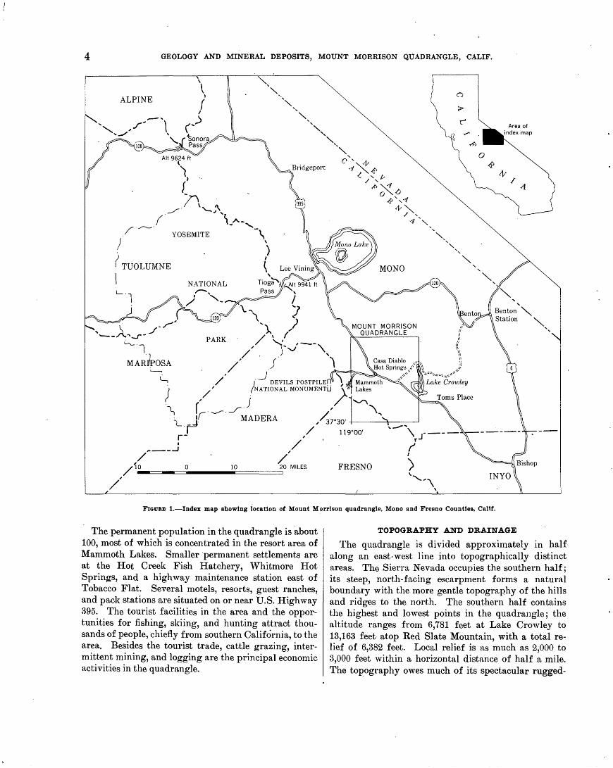
Page FIGURE 1. Index map showing location of Mount Morrison quadrangle, Mono and Fresno Counties, CaliL _ _ _ _ _ _ _ _ _ _ _ _ _ _ 4
2. Generalized geologic map of the Mount Morrison quadrangle showing areal distribution of major rock types_ _ _ 7 3. Diagram shoWing approximate average mineralogic compositions of the metasedimentary rocks of the Mount
Morrison roof pendant in terms of the essential minerals_______________________________________________ 8 4. Photomicrographs showing relicts of probable Radiolaria tests in meta chert ____________________________ -_-- 11

CONTENTS V
Page FIGURE 5. Ltike Dorothy hornfels showing replacement of dark layers along a prominent joint set______________________ 12
6. Photomicrographs of calcareous quartz sandstone __________________ : ___________________ ._________________ 16 7. Brecciated qhert interlayers in calcareous quartz sandstone on McGee Mountain___________________________ 19 8. Crossbedding in the Mount Morrison sa-ndstone south of Convict Lake____________________________________ 22 9. View looking southwest across Convict Lake___________________________________________________________ 23
10. Outcrops of Mount Baldwin marble at the type locality on east side of Laurel Creek________________________ 24 11. View looking southwest at Mammoth Rock, light pinnacle in right center__________________________________ 24 12. Chert nodules in the Mount Baldwin marble north of Mildred Lake on Convict Creek______________________ 25 13. Map showing distribution of clastic (western) facies rocks, dominantly Ordovician in age, in east-central California
and Nevada ____ ~--------------------------------------------------------------------------------- 29 14. Diagrammatic section of metavolcanic rocks before folding and intrusion by granitic rocks____________________ 34 15. A, photomicrograph of the metaquartz latite tuff of Skelton Lake showing texture resembling that of welded tuff.
B, photomicrograph of the Bishop tuff of Gilbert (1938), showing texture typical of welded tuff______________ 35 16. Map showing dist:r:ibution of diorite and related rocks ______________________________________ :.____________ 39 17. Sharp contact between Round Valley Peak granodiorite and Mount Aggie formation in Esha Canyon_________ 41 18. A, swarm of apparently elongate dioritic inclusions in Round Valley Peak granodiorite near contact with Mildred
Lake siliceous hornfels south of quadrangle, northeast of Big McGee Lake. B, joint traae parallel to plane of foliation___ 41 19. Classification of granitic rocks used in this report_______________________________________________________ 42 20. Round Valley Peak granodiorite-graphic representation of modes________________________________________ 45 21. Wheeler Crest quartz monzonite-graphic representation of modes________________________________________ 46 22. Quartz monzonite similar to the Cathedral Peak granite and smaller felsic masses-graphic representation of modes___ 4 7 23. Map showing ·structures attributed to forcible emplacement of granitic rocks _______ ~_______________________ 51 24. Map showing flow structures in the older rhyolite ______________________________ _,------------------------ 54 25. Photograph and sketch of lacustrine tuffaceous sandstone unconformably overlying flow-banded older rhyolite
along Hot Creek gorge_____________________________________________________________________________ 55 26. Photograph looking southwest across Long Valley at the Sierra Nevada __ --------------------------------- 58 27. View from the upland surface atop McGee Mountain (altitu.de 10,000 feet) looking southwest along the same line
of sight as in figure 26 ___________ ~ _ _ _ _ _ _ _ _ _ _ _ _ _ _ _ _ _ _ _ _ _ _ _ _ _ _ _ _ _ _ _ _ _ _ _ _ _ _ _ _ _ _ _ _ _ _ _ _ _ _ _ _ _ _ _ _ _ _ _ _ _ _ _ _ _ 58
28. Silica-refractive index diagram showing curve established for volcanic rocks of the Mammoth embayment in relation to curves established in other areas _____________________________________ '----~------·---------- 60
29. Comparison of mapped volcanic flows based on the refractive indices of fused samples, and relation of isolated volcanic rocks and inclusions to the larger mapped units as determined by refractive indices of fused samples___ 62
30. Variation diagram of the volcanic series of the Mammoth embayment showing classification according to the 11 alkali-lime index"________________________________________________________________________________ 63
31. Correlation chart showing mapped and tentative subdivisions of the glacial deposits in the Mount Morrison quadrangle, and their probable relation to the glacial stages of Blackwelder (1931) _ _ _ _ _ _ _ _ _ _ _ _ _ _ _ _ _ _ _ _ _ _ _ _ _ 66
32. View looking south up McGee Creek from boulder deposit atop McGee Mountain__________________________ 67 33. Transported boulders of Round Valley Peak granodiorite atop McGee Mountain __________________ -·-_______ 68 34. Stereotriplet and map of the moraines in the Convict Lake area__________________________________________ 69 35. View looking north across McGee Creek moraine offset along the Hilton Creek fault________________________ 71 36. 37.
View looking south at the moraines of Laurel and Sherwin Creeks________________________________________ 72 Stereoscopic ·pair of aerial photographs of a large inactive rock glacier in Sherwin Creek ________ ·_____________ 7 4
38. Looking east across Hot Creek at tuffaceous sandstone of Pleistocene age __________ .:.._______________________ 76 39. Area of principal thermal activity and associated alteration______________________________________________ 80 40. Steeply plunging fold in Buzztail Spring formation south of McGee Creek__ _ _ _ _ _ _ _ _ _ _ _ _ _ _ _ _ _ _ _ _ _ _ _ _ _ _ _ _ _ _ _ 82 41. Gently plunging.syncline in Bright Dot formation northeast of Mildred Lake______________________________ 82 42. View southeast from Laurel Mountain showing the Laurel-Convict fault on the east side of Convict Creek_____ 83 43. Geologic map of the Tiptop prospect__________________________________________________________________ 95
TABLES
Page T A BI-E 1. Climatological 'd~;tta _________________________________________________________________________________ _ 5
12 14' 33 40 43 47 59 61 81 81
2. Chemical analysis of siliceous hornfels ________________________________________________________________ _ 3. Chemical analyses of siliceous calc-hornfels _____________________________ . _______________________________ _ 4. Chemical analyses and norms of metavolcanic rocks ____________________________________________________ _ 5. Modal analyses of diorite and related rocks ________________________________________________ :. ___________ _ 6. Modal analyses of the granitic rocks __________________________________________________________________ _ 7. Chemical analyses and norms of th\:l Round Valley Peak granodiorite _____________________________________ _ 8. Petrographic summary of the volcanic rocks ___________________________________________________________ _ 9. Chemical analyses an<;l norms of volcanic· rocks _________________________________________________ ~ ______ _
10. Thermal data---------------------------------------------------------------------------------------11. Chemical analyses of water from thermal springs--------------------------------------------------------

GEOLOGY AND MINERAL DEPOSITS OF THE MOUNT MORRISON QUADRANGLE, SIERRA NEVADA, CALIFORNIA
BY C. DEAN RINEHART and DoNALD C. Ross
ABSTRACT
The l\iount Morrison quadrangle includes part of the east front of the Sierra Nevada in Mono and Fresno Counties, Calif., ancl lies midway between Mono Lake on the north and Bishop on the south. The Sierra Nevada, characterized by alpine topography, occupies the southern half of the quadrangle and is separated from an area of relatively gentle topography to
-the north by a steep ea~Stward-trending escarpment 2,500 to more than 8,000 feet high. Altitudes in the quadrangle range from less than 6,800 to more than 18,100 feet.
The geologic units. mapped can be grouped into metasedimentary rod:s of Paleozoic age, metavolcanic rocks of Mesozoic nge, and intrusive rocks of Cretaceous age, which occur chietly in the Sierra Nevada, and extrusive and sedimentary rocks of Cenozoic age, which occupy the area north of the Sierra.
The two groups of metamorphic rocks compose the Mount Morrison roof pendant, which underlies 42 square miles in the Sierrn Nevada and consists of a grossly homoclinal sequence of beds a little less than 50,000 feet thick. .The beds strike northwestward and dip steeply, with tops to the west. The common mineral assemblages of the rocks are typical of· the hornblende hornfels metamorphic facies of Turner and consist of quartz, mica, and feldspar in the more aluminous rocks and diopside, tremolite or actinolite, grossularite, and locally, wollastonite In the more calcareous varieties.
The metasedimentary rocks of Paleozoic age compOEle the eastern three-fourths of the pendant. They are divided into 27 cartographic units, totaling 82,400 feet in maximum stratigraphic thickness, that range in age from Early Ordovician to Permian ( ?) . The rocks are divided into three blocks by two major fnults which strike almost parallel to the beds. The easternmost block contains six formations, with an approximate total thickness of 8,200 feet. The common rocks in this block are thin-bedded siliceous and pelitic hornfels, marble, slate, metachert, and a lesser amount of thin-bedded siliceous calc-hornfels and· thick-bedded calcareous quartz sandstone. Graptolites of Early Ordovician (Arenig) and Middle Ordovic\an (Caradoc) ages were found at several localities. The middle block comprises 10 formations with a total thiclmess of about 16,900 feet. The lower half of this block consists. chietly of thin-bedded1 siliceous ·and pelitic hornfels, slate, siliceous calc-hornfels, and marble: the upper half con·Sis.ts of alternate thin-bedded siliceous hornfels and thickbedded calcareous quartz sandstone. Graptolites of Middle Ordovician (Caradoc) age were collected from the lower half, and one poorly preserved graptolite that may be as young as Silurian('!) was collected ·near the top The westernmost block comprises five formations totaling 7,300 feet in thickness. Th~ lowest third of the block consists largely of thin-bedded siliceous hornfels and metachert but includes one distinctive
fossiliferous marble unit 500 feet thick. The upper two-thirds eonsists of thin- to thick-bedded siliceous hornfels, siliceous calchornfels, and a few layers of intraformational conglomerate. Brachiopoda collected from the marble unit in the lower part of the block are of Pennsylvanian age, and an assemblage including brachiopods, corals, and bryozoans from the upper part may be as young as Permian ( 'l) .
With the exception of sandstone and marble all the metasedimentary rocks are fine grained with an average grain size of about 0.03 mm. The textures are typically gr'anoblastic, but relict clastic texture is common throughout the entire ·stratigraphic section and indicates that the rocks are epiclastic. The most common parent rock was mudstone or siltstone containing varied proportions of clay and marl ; less abundant types include limestone, sandstone, and chert. ·
On the basis of both lithology and fauna the pre-Pennsylvanian strata of th·e Mount Morrison pendant appear to belong to the clastic or western facies (as opposed to the eastern carbonate facies) of the. lower Paleozoic in the Great Basin. Possible stratigravhic equivalents include the Vinini, Palmetto, and Valmy formations of Nevada, the Ramshorn slate and Phi Kappa formations of Idaho, and the Ledbetter slate of Washington. The Pennsylvanian and Permian(?) section contains less carbonate and mot·e clastic material than the nearest described stratigraphic sections of comparable age, although the fauna contains elements tYilicnl of the lower part of the Ely limestone and lower part of the Oquirrh formation, both from the Great Basin.
The western fourth of the pendant consists of metamorphosed felsic volcanic tuffs and lesser amounts of tlaws, hypabyssal intrusives, and intercalated tuffaceous and epiclastic sedimentary layers of Mesozoic age. Most of the rocks range in composition fr~m andesite to quartz latite. They are divided into five cartographic units totaling about 13,600 feet in maximum thi~kness. 'l'he contact with the underlying Paleozoic metasedimentary rocks is largely cut out by intrusive granitic rock, but two short segments are exposed-one at the north and the other at th~ south end of the 11end~mt. Faulting at both localities has obscured the original contact, but the same contact exposed in the area west of the quadrangle appears to be conformable. Rounded fragments of metasedimentary ~ocks in the lowest part of .the metavolcanic section, however, s~ggest the possibility of an erosional unconformity. Bedding is sparse and is well 4efined in only one unit, which consists of tuffaceous metasedimentary rocks and marble 1,000 feet thick. One of the most distinctive units is a massive weakly foliated quartz latite, 4,000 feet thick, which contains structul'les suggestive of welded tuff. Th~ age of the metavolcanic sequence is considered to be Tri~ssic or Jm;assic on the basis Of· Early Jurassic fossils collected
1
2 GEOLOGY AND MINERAL DEPOSITS, MOUNT .MORRISON QUADRANGLE, CALIF.
froni lithologically similar rocks in the area northwest .of the quadrangle. The rocks there lie along the projected strike of the metavolcanic sequence in the Mount Morrison pendant.
Intrusive granitic rocks of the Sierra Nevada batholith occupy about 40 square miles in the quad.rangle and form a consang~ineous magmatic suite of six plutons ranging .in composition from granodiorite to quartz monzonite. ·The average composition of the granitic suite is approximately granodiorite. Four of the plutons extend considerable distances beyond the quadrangle boundaries and occupy an additianal area of 140 square miles. Contacts of plutons with ·ane another and with metamorphic rocks~are typically sharp, although granodiorite grades locally into thin diorite zones along some pluton margins. The sequence of intrusion shows no systematic relation to· composition, insofar as could· be determined by field ·relationships, such as apophyseal dikes, inclusions of one granitic type within .another, and truncation of structures in one pluton by another. At least two plutons were emplaced with sufficient force to have sharply deflected the wallrock structure, which normally forms a uniformly northwest regional grain. Based on stratigraphic correlation and ·wallrocli: structure, one granodiorite pluton displaced its wall 8 miles laterally. The age of the granitic suite is provisionally considered to be middle Cretaceous on the ·basis of lead-alpha age determinations on related rocks in tl}e, Bishop district to the .s<::mth and on potassium-argon age determfnations on related rocks from Yosemite National Park to the northwest.
The voicanic rocks of Cenozoic age are composed of nine mapped units and cover 50 square miles in the northwestern quarter o.f the quadrangle. In addition, several small .volcanic remnants less than a square mile in total area, are perched on old land surfaces in the Sierra Nevada near the range front. The rocks range in composition from basalt to rhyolite and in age from Pliocene (?) to Recent ( ? ) . The sequence of extrusion is approximately as follows: Andesite flows, rhyolite domes and flows, and ·quartz latite domes during the Pliocene(?) ; rhyolitic tuft', rhyolite domes and flows, and basalt flows during the Pleistocene; 9livine-bearing quartz latite flow and rhyolitic pumice during the Recent ( ? ) . Chemical analyses representing each unit show that the suite is intermediate' in composition between calc-alkalic and alkali-calcic. Silica percentages as estimated from refraoctive indices of fused· samples of the voleanic rocks supplement the chemical analytical data and aid in correlating disconnected segments of mafic flows.
Six major canyons issue ·from the Sierra Nevada in the quadrangle, and each has at its mouth massive embankm~nts of moraine representing at least two major advances of Pleistocene glaciers. Two canyons show evidence of three major advances, and one shows evidence of four. The moraines were deposited during the Sherwin, Tahoe; and Tioga glacial stages, as established by Blackwelder. The "fact that in. one canyon four sets of moraines were recognized indicates that one of the three stages, probably Tahoe or Sherwin, includes two major glacial advances. An additional, and· considerably older, glacial stage is represented by high-level till now separated from the source of its constituent boulders by a canyon 2,500 feet deep. This till represents the oldest stage (McGee) recognized by Blackwelder. The youngest deposits of ice-transported material consist of about 30 rock glaciers found at altitudes ranging from 8,800 to 11,600 feet. They are undoubtedly of Recent age, and those above 11,000 feet may still be active.
During part of the Pleistocene a lake occupied an area of 100 square mi1es, chiefly in the northeastern part of the quadrangle, where extensive deposits of tuffaceous sandstone, con-
glomerate, and clay were 1aid down and terraces were cut on volcanic rocks and moraine. Extensive assemblages of diatoms were collected from the lacustrine beds at three localities. Two assemblages represent the central part of the ancient lake and contain species of Pleistocene, possibly middle Pleistocene age. The third assemblage was collected from near the margin of the lake and contains diatoms as old as early Pleistocene or late Pliocene ( ? ) .
The dominant element of pre-Cenozoic structure in the quadrangle i~ the grossly homoclinal westward-dipping sequence of Paleozoic and Mesozoic strata that makes up the Mount Morrison roof pendant. These strata are inferred to be part of the east limb of a synclinorium/whose axis lies west of the quadrangle and is approximately coincident with the axis of the Sierra Nevada batholith. A major northwestward-trending fault, the Laurel-Convict fault; cuts through the center of the pendant and is the boundary between Ordovician and Silurian(?) strata on the .east and Pennsylvanian and Permian(?) strata on the west.
The strata east of the IJaurel-Convict fault (Ordovician and Silurian ( ?) ) strike northward, are overturned to the west, and dip steeply eastward. ·Faults are abundant and are dominantly strike faults, commonly showing large components of left-lateral movement. A steeply plunging major fold was recognized near the east margin of the pendant, and steeply plunging minor folds are typical east of the Laurel-Convict fault; many minor folds are apparently related to lateral movement along faults. The strata west of the fault (Pennsylvanian, Permian ( ?) , and Mesozoic), on the other hand, strike northwestward, dip westward, and are not generally overturned; they are cut by· a few norQJ.al faults and locally are deformed into open gently plunging folds. These strata. west of the Laurel-Convict fault are concordant with the fault, whereas those east of the fault are markedly discordant; the stratigraphic separation along the fault is about 8,900 feet: Rocks of Devonian and Mississipian age were not identified in the pendant and are probably missing from the interval represented by the Laurel-Convict fault. The fact that rocks of this age are also missing along erosional unconformities in two nearby areas sug.gests that the Laurel· Convict fault coincides with an unconformity.
During the Cenozoic era, the area was extensively deformed . along numerous high-angle normal faults and gentle warps. The most spectacular feature created by Cenozoic faulting is the Long Valley basin, a crescent-shaped graben, concave southwest, which lies between the Sierra Nevada escarpment on the south and an escarpment of comparable height on the north, connecting Glass Mountain and Bald Mountain. In addition to the boundary faults that delimit the basin, numerous high-angle northward- to northwestward-trending normal faults cut the volcanic rocks that occupy the west-central part of the basin ; some of these scarps are more th!ln 500 feet high.
A gravity survey of the Long Valley ba!;!in revealed an anomaly of 75 milligals in the form of an elliptical gravity low near the center of the basin. The gravity gradients along the margins of the basin are typically steep and are interpreted as evidence of buried steeply dipping fault scarps, along which Cenozoic clastic and volcanic rocks are in contact with pre-Cenozoic crystalline rocks. Depths to pre-Cenozoic bedrock, computed at five localities, runge fr.om 3,500 to 12,000 feet. Depths are least along the Sierra Nevada front, intermediate along the Glass Mountain-Bald Mountain escarpment, and greatest along the east margin where the rim of the basin is lowest and no surface evidence of faulting was recognized.
Andesite and rhyolite of Pliocene(?) age are offset vertically
INTRODUCTION 3
more than 2,000 feet along faults. that bound the basin on the north, and, since·tbe earliest glaciation,. about 2,500 feet of· vertical displacement is indicated along frontal faults of the Sierra Nevada. Indirect evidence based on relationships shown by the Pliocene(?) volcanic units and on the interpretation of the gravity survey suggests that the Long Valley basin was a well defined structural feature prior to the extrusion of the Pliocene( ?) volcanic units. The youngest movement recognized in the area: is along a normal fault that displaces moraine of the latest major glacial stage (Tioga) a distance of more than 50 feet.
A variety of metallic mineral d'eposits baYe been prospected in the quadrangle, but the only significant production has been from deposits of gold, silver, and tungsten. Scheelite, the only tungsten-bearing mineral, occurs in contact metamorphosed calcareous rocks along contacts with granitic rocks and has been exploited at five localities in the Sierra Nevada part of the quadrangle. The total tungsten produced is probably between 12,000 and 15,000 units of 60 percent WOs. The deposits have not been worked since 1957. Gold and silver and subordinate amounts of copper and lead have been produced sporadically from mines of the Mammoth district in the Sierra Nevada near the west boundary of the quadrangle. The deposits are in altered metavolcanic rocks and contain free gold, auriferous pyrite, and sulfides of silver, copper, and lead. The ore minerals are disseminated in the host rock and also occur locally in quartz veins. The period of· most production was from 1878 to 1881 ; since then mining bas been sporadic, and in 1958 one small gold-silver deposit was the only property being worked. Total production probably does not exceed $1 million. An extensive deposit of kaolinite in altered rhyolite in the north-central part of the quadrangle was the ·principal nonmetallic commodity being exploited in i959.
INTRODUCTION
The Mount Morrison quadrangle was mapped by the U.S. Geological Survey in cooperation with the California Division of Mines as part of a study of tungstenbearing· and potential tungsten-bearing areas in eastcentral California (pl. 1). The quadrangle is adjacent to and has a geologic setting somewhat .similar to the highly productive Bishop district; it contains a few small mines and prospects that have been worked recently.
An unpublished small-scale map of the quadrangle by E. B. ~1ayo, examined before beginning the fieldwork, showed that the quadrangle contains a great diversity of rock types and suggested that metasedimentary and meta volcanic rocks in a large roof p~ndant might be divided into formations. During the first day of .field work southeast of Convict Lake, Dallas Peck found graptolites which, according to R. J. Ross, Jr., u.re genera common to the Ordovician of the Great Basin. This proved to be the first recognized occurrence of rocks of Ordovician age in the Sierra Nevada. Shortly thereafter, other members of the party found additional Ordovician graptolite localities and also found fairly well-preserved brachiopods which, according to MacKenzie Gordon, Jr., are of Pennsylvanian.and PerInian age. The presence of .fossiliferous rocks and the
recognition that the pendant could be subdivided into formations indicated that particular attention should be O'iven to the Paleozoic metasedimentary rocks that
b
compose a stratigraphic section more than 30,000 feet thick. Such emphasis serves two purposes: ( 1) areas favorable for the occurrence of tungsten deposits can be identified by .accurately delineating on a map the calcareous units ·and their contact relationships with granitic rocks; and (2) the establishment of a str~tigraphic section, with a detailed description of the rock units, fixes a ·regional stratigraphic tie-point in the Si~rra Nevada where fossiliferous rocks are scarce.
LOCATION, ACCESSIBILITY, AND CULTURE
The :L\iount Morrison 15-minute quadrangle is in southwestern :Mono County and eastern Fresno County (fig. 1). The quadrangle is approximately bisected diagonally by U.S. Highway 395, the principal northsouth route in eastern California; the nearest towns along the high way are Lee Vining, 17 miles to the northwest, and Bishop, 29 miles to the southeast. A wellmaintained asphalt road joins U.S. Highway 395 near Casa Diablo Hot Springs and extends westward through the resort community of Mammoth Lakes to a group of six lakes, known as the Mammoth Lakes, all within a mile of the west quadrangle boundary. A branch of this road, north of the St. Joseph Chapel, continues westward 12.5 miles to the Devils Post pile National Monument. Other secondary roads extending westward from U.S. Highway 395 follow· the lower courses of Convict and McGee Creeks. Privately owned mine roads, not open to the public and unsuitable for passenger cars, provide access to much of Hilton Creek, the head waters of Laurel and McGee Creeks, and McGee Mountain. The northeastern part of the area is accessible chiefly by secondary roads that join U.S. Highway 39.5 west of Lookout Mountain, at Casa Diablo Hot Springs, and near Whitmore Hot Springs. The latter road extends around the north end of Lake Crowley and connects with California Highway 120 near Benton, 4 miles west of Benton Station on U.S. Highway 6. Several other roads, some suitable only for jeeps or other vehicles with four-wheel drive, provide further access in the northen1 half of the quadrangle.
The nearest rail connection is at Laws, about 35 miles east of the quadrangle by way of U.S. Highway 395 and 6; Laws is the northern terminus of a narrow~gage line that connects with a standard gage line farther south in Owens Valley. Landing facilities for light aircraft are available at two places in the quadrangle, one near the Arcularius Ranch and the other along U.S. Highway 395 near the Mammoth School; neither fuel nor maintenance service is ava~lable at either landing field.
4 GEOLOGY AND MINERAL DEPOSITS, MOUNT MORRISON QUADRANGLE, CALIF.
ALPINE
Alt 9624 ft \
1 )
f ./'.\'- ~
_/ ""' r· 1 .. A-
/·~· YOSEMITE '--\
J )
( TUOLUMNE ( Lee Vining
I '~/ NATIONAL Tiog'a'lffr. Alt 9941 ft
Pass/"", I 7 "' ~ .. )
PARK · / ' / ') ,--, " 'v "' / . '
, ;· \ / . ~~,__~
L, /, ). _)DEVILS POSTPILE .. \
) ,/' j NATIONAL MONUMENTLJ )o "'-"..._ "\ r,. __ . ..._........_r· /, ' ....
0
1_. =-J' MADERA ,/ 3r 30, +-------'\-... ----... --'
I / 119°00' \ ----r- , rj
I / t' ,_ __ ....J /' I
/ 1( 0 10 20 MILES FRESNO )
--~~~~---------=======~ \ /' ''\,
FIGURE 1.-Index map showing iocatlon of Mount Morrison quadrangle, Mono and Fresno Counties, Caltf.
The permanent population in the quadrangle is about 100~ most of which is concentrated in the resort area of Mammoth Lakes. Smaller ·permanent settlements are at the Hot Creek Fish Hatchery, Whitmore Hot Springs, and a highway maintenance station east of Tobacco Flat. Several motels, resorts, guest ranches, and pack stations are situated on or near U.S. Highway 395. The tourist facilities in the area and the opportunities for fishing, skiing, and hunting attract thousands of people, chiefly from southern California, to the area. Besides the tourist trade, ~attle grazing, intermittent mining, and logging are the principal economic activities in the quadrangle.
TOPOGRAPHY AND DRAINAGE
The quadrangle is divided approximately In half. along an east-west line into topographically distinct areas. The Sierra Nevada occupies the southern half; its steep, north-facing escarpment forms a natural boundary with the more gentle topography of the hills and ridges to the north. The southern half contains the highest and lowest points in the quadrangle; the altitude ranges from 6,781 feet at Lake Crowley to 13,163 feet atop Red Slate Mounta,in, with a total relief of 6,382 feet. Local relief is as much as 2,000 to 3,000 feet within a horizontal distance of half a mile. The topography owes much of its spectacular rugged-

INTRODUCTION 5
ness to glaciation as attested by the abundance of cirques, aretes, and tarns.
The more gentle topography to the north has a maximum relief of 2,601 feet and ranges in altitude from 6,781 feet at Lake Crowley to 9,382 feet atop a volcanie dome northwest of the St. Joseph Chapel. The greatest local relief is· generally less than 1,000 feet within a horizontal distance of half a mile.
All streams in the quadra.ngle northeast of the Sierra Crest are· tributary to Owens River, which flows into Owens Lake-a desert sink 80 miles south of the quadrangle. Streams that head in the Sierra Nevada are permanent, whereas those that have their source in the lower area north of the range are intermittent. Streams southwest of the crest of the range drain into Fish Creek, a tributary of the San.Joaquin River. All the streams become swollen during spring and early summer when the winter snows are melting; during this period the intermittent streams in the north half of the quadrangle show their greatest flow. Springs are locally abundant in the Sierra Nevada, particularly during the period of abundant run-off; for example, about 4 miles up l\fcGee Creek eight springs coalesce to feed I-Iorsetail Falls.
CLIMATE AND VEGETATION
The climate of the area can be divided into two types that correspond to the topographic division. The southern mountainous half of the quadrangle is characterized by severe winters and cool summers, whereas the ~1orthern half has less severe winters, less precipi-tation, and som~wha.t warmer summers. .
The major climate control is the Sierra Nevada. The high altitude of the range lowers the temperature of .the region and also serves as a barrier to the eastwardmoving winter storms. On the western slope of the range and near the ~rest winter precipitation is abundwt, but on the steep eastern slope precipitation dimin.; ishes sharply with decrease in altitude, as shown in table 1.
Except for the station near Convict Lake, the weather stations listed in table 1 lie outside the quadrangle to the north and west, but the temperature. and precipitation at each of the stations probably closely resemble values for areas at comparable altitudes within the quadrangle. Ellery and Gem Lakes are probably representative of much of the high country along the east side of the Sierra Nevada, but in the still higher region near the crest, colder winters and more winter precipitation would be expected. The other four sta· tions reflect the climate of the north half of the quadrangle, witJh rather cool average tempera.ttrr~. but with much less precipitation. ·
TABLE 1.-0limatoloyical data
[Data compiled from U.S. Weather Bureau Annual Summaries, "Climatological data for United States, by sections," 1956]
Temperature (°F) Precipitation (inches)
Eleva-Jan- I July Station tion Novem- Per-
(feet) uary aver- Max- Min- Mean Mean through cent aver- age imum imum annual annual April total age
------------------Ellery Lake ____ 9,500 23 55 83 -25 39 31 26 87 Gem Lake _____ 9,000 26 60 91 -20 43 25 19 76 Lundy Lake ___ 7, 700 26 63 90 -34 45 15 12 80 Convict Lake
(Fish and Game Ex-perimental Station) _____ 7,100 26 63
92 -18 ------- -------r------- ----85 Mono Lake ____ 6,500 30 68 ------- ------- 49 13 11 Bridgeport_ ___ 6,400 23 59 92 -7 42 11 9 82
I
According to the classification of Kt>ppen (described briefly in James, 1935, p. 370-379) the quadrangle is almost entirely in climate zone Dsb (rainy climate with severe winters, dry, cool summers). It is possible that part of Long Valley may be BSk (dry, semiarid, average annual temperature 64°F) and the high country along the range crest is probably locally an EH climate (polar climate with no warm season, humid). All the stations that record temperature and precipitJation data are within the area of hmnid climate, but the quadrangle is near the border of. the large semiarid climate
· area of the Great Basin. Forest, consisting chiefly of Jeffrey and lodgepole
pine, covers most of the lower area in the north half of the quadrangle and parts of the Sierra Nevada. The for~sted areas also include western white pine, limber pine, Sierra juniper, red fir, white fir, mountain hemlock, and pifion pine. Only about half of the Sierra Nevada has enough trees to be considered forest cov-
. ered, and areas underlain by metamorphic rocks are particularly barren. Timberline is at an altitude of about 11,300 f.eet and at this level whitebark and lodgepole pines grow in small, shrublike clumps. Aspen, willow, cottonwood,· alder, and water birch are locally abundant near streams and springs.
The unforested part of the,quadrangle, with the exception of the barren high country, is sparsely covered with sagebrush and other desert-type vegetation. Sage, although characteristio of the valley ar~as, also grows profusely at an altitude of about 10,000 feet on the upland erosion surface of McGee Mountain. Manzanita, mountain-lilac, and other low-growing vegetation are common along the lower slopes of the westcentral part of 'the quadrangle.
PREVIOUS WORK
Published. geologic reports relating to the Mount Morrison 15-minute quadl'angle deal with a restricted area, a limited phase of the geology, or with a larger

6 GEOLOGY AND MINERAL DEPOSITS, MOUNT MORRISON QUADRANGLE, CALIF.
area of which the Mount Mo~rison quadrangle constitutes only a small part. A geologic map of the quadrangle and a considef!able ~dj oining area at a scale of 1 :125,000 was made by E. B. ·Mayo in the mid 1930's; a copy of this map is on file in the San Francisco office of the California Division of Mines. Only a small part of the map, covering an a.rea in the Convict ~and Laurel Creek basins, was published (Mayo, 1934a)., Mayo also prepared a short paper on a fossil that was brought w him from the quadrangle (Mayo, 1931), •and another on Pliestocene Long V a:lley Lake (Mayo, 1934p).
References to the structure of the area can be found in a paper by Mayo (1941) on the deformation in the interval Mount Lyell-Mount Whitney, Calif., but because the map is small scale and the geology considerably generalized little interpretation of the structural history of the quadrangle can be made. An abstract by Matthes ( 1939a) presents some ideas on the origin of the Sierra Nevada escarpment.
The volcanic rocks of the qimdrangle are discussed briefly in a paper by Gilbert (1941) on the late Tertiary geology southeast of Mono Lake. This paper is helpful particularly beeause an attempt is made to rel1ate the local volcanic series .to the Esmeralda formation of Oligocene and Miocene age in Nevada. The volcanic rocks were .also studied by Chelikowsky ( 1940), with emphasis on the tectonics of the rhyolite.
The glaeial deposits have probably been studied in more detail than other rock units in the· quadrangle. Blaekwelder (1931) studied the glacial geology of a large area in the Sierra Nevada and the Basin Ranges, and his paper includes the description of glacial deposits in several eanyons in the quadrangle. He also prepared two abstracts. that deal with glacial deposits in the quadrangle (Blackwelder, 1928, 1929). Kesseli studied the rock glaciers of the east side of ·the Sierra Nevada in considerable detail and devoted a large part of his paper (1941a) to the rock glaciers in the canyon of Sherwin Creek, for which he presented arguments in favor of a glacial origin. Kesseli ( 1941b) was also concerned with the slight changes of eourse of sueeessive valley glaeiers and their importanee in interpreting periods of interglaciation ; in this study he used as examples several of the moraines in the quadrangle.
The name foremost in glacial geology of the Sierra Nevada is Francois Matthes. He spent many years studying the glacial geology of the range, but unfortunately little of his work on the east side of the range was published. The writers of this report were in possession of many of Matthes' field notes, unpublished short papers, photographs, and letters in which he discussed glacial problems with Blackwelder, Mayo, Kesseli, and others. These papers show that he had made careful observations and had given considerable
thought to the loeal glacial history. This work was to have been incorporated into a comprehensive treatise that was never undertaken because of Matthes' death in 1948. Some of Matthes' ideas on the glacial geology and the structural evolution of the east scarp of the Sierra Nevada ea.n be found in a chapter he wrote entitled "A geologist's view" (Peattie, 1947, .p. 166-214).
Most of the thermal springs of the area were visited by Waring and briefly described in his paper on the springs of California ( 1915). A later paper by Stearns, and Waring (1937, p. 1~6-127) on the thermal springs of the United States repeats Waring's data with minor additional information. A violent steam eruption at Casa Diablo Hot Spring in 1937 was described by Blake and Matthes (1938).
The ··mineral deposits, particularly the gold deposits of the M~mmoth d~striet, have been mentioned in several California Division of Mines publieations, and the
· most reeent report, on the mineral resources of Mono County by Sampson and Tucker (1940) summarizes most of the data. Most. of the tungsten deposits were examined during the "Strategic Minerals Investig~tions" of the U.S. Geological Survey, _and a prelim~nary report by Lemmon (1941, p. 97-100) describes briefly the deposits along Hilton Creek and on McGee Mountain. Tucker and Sampson also briefly describe t~e early operations at the Scheelore mine (1941, p. 581).
PRESENT INVESTIGATION
Fieldwork commenced in June 1953 and was completed in August. 1955. The writers spent a total of 13 man-months in mapping the quadrangle and during the field season of 1953 were ably assisted by D. L. Peck and H. K. Stager. In addition, L. C. Pakiser made a gravity survey of the Long Valley basin in 1955, and the results of his study are included as a chapter in this report.
.The geology was plotted on U.S. Geologieal Survey aerial photographs at a scale of a:bout 1: 50,000 and was transferred by inspection to a topographic base, prepared by multiplex methods from the aerial photographs. This method .was particularly su~table because of abundant exposures, distinctive rock units that were identifiable on the aerial photographs, an excellent base map, and distinctive topography which facilitate~ the transfer from photos to base map. Limited use was made of U.S. Forest Service aerial photographs at a scale of 1 : 20,000.
ACKNOWLEDGMENTS
During the fieldwork the writers enjoyed the friendly cooperation of the local residents and the mine owners and lessees, among whom the following were particularly helpful: C. Beauregard, J. F. Birchim, E. B.

METASEDIMENTARY ROCKS OF PALEOZOIC AGE 7
J?elight, G. B. Hartley, W. H. Huntley, J. H. Lucas, A. G. Mahan, Jr., A. F. Messmore, J. E. Morhardt, D. H. Nicoll, R. W. Phelps, R. B. Schwerin, H. A. Van Loon, F. H. Watkins.
Important cont):ibutions to the organization and clarity of this ·report were m~de by P. C. Bateman and D. W. Peterson, both of whom had the patience to conscientiously review the manuscript. Their assistance is gratefully acknowledged.
GEOLOGIC SETTING
The rocks exposed in the Mount Morrison quadrangle consist of granitic and metamorphic rocks, limited almost entirely to the Sierra Nevada; volcanic rocks that cover most of the northwestern quarter of the quadrangle; and sedimentary rocks that are distributed widely throughout the quadrangle but' are most abundant in Long Valley (pl.l and fig. 2).
The metamorphic rocks, to which a large part of this report is devoted, are exposed over an area of 42 square miles and form the Mount Morrison roof pendant. The pendant comprises two sequences of metamorphic rocks-a sequence of metasedimentary rocks of Paleozoic age, which occupies the eastern two-thirds of the pendant, and a sequence of chiefly meta volcanic rocks of Mesozoic age, which occupies the western third. The strata in both sequences strike northwest, dip steeply, are grossly homoclinal, and are progressively younger to the west. Granitic rocks of Mesozoic age enclose;and intrude the pendant rocks. They consist chiefly of two main types, quartz monzonite and granodiorite, but also include scattered bodies of albite granite, aplite, diorite, and gabbro. Volcanic rocks, which occupy much of the northwestern part of the quadrangle, consist of flows and domical protrusions of Cenozoic age tha.t range in composition from basalt to rhyolite. The most widespread sedimentary unit, excluding Recent valley fill, is lacustrine sandstone, which is derived largely from the volcanic rocks and which laps onto their east margin. Other sedimentary units include valley fill, glacial till, talus, alluvial fans, slope wash, and pumice.
METASEDIMENTARY ROCKS OF PALEOZOIC AGE
The eastern and larger part of the Mount Morrison roof pendant is composed of a thick sequence of metasedimentary rock~ that is exposed over an area of 27 square Irtiles (pl. 1). Two additional small isolated outcrops, one west of Sherwin Creek and the other near the north boundary of the quadrangle about 11j2 miles west of the Arcularius Ranch, constitute a little less than a square mile of metasedimentary rocks.
The bulk of the stratigraphic section is composed of fine-grained dark-colored quartz-rich. hornfels; other lithologic types, widely distributed throughout the se-
0
D Sedimentary rocks
EJ Volcanic rocks
/+++1 Granitic rocks
5 MILES
EXPLANATION
D . . Metavolcanic rocks
Metasedimentary rocks M, McGee Mountain block. C, Convict Lake block. B, Bloody Mountain block
~--····· Fault
Dotted where concealed
FIGURE 2.-Generalized geologic map of the Mount Morrison quad;rangle showing areal distribution of major rock types.
quence but subordinate in quantity to hornfels, are marble, sandstone; slate, metachert, and quartzite. Some of the formations delineated -on the map (pl. 1) are homogeneous lithologic units, but most consist of a variety of lithologic types, distinguished from each other by differences in proportion and sequence of their constituent rock types. Color differences between most of the formations are visible in the field and on aerial photographs. The contacts between formations appear to be conformable a~d commonly are gradational through a few tens of feet. The only observed breaks in the sequence are marked by faults. Sedimentary facies changes are evident in some formations even within the relatively short strike length exposed in the pendant. In particular, the Bloody Mountain, Lake
8 GEOLOGY AND MINERAL DEPOSITS, MOUNT MORRISON QUADRANGLE, CALIF.
Dorothy, and Bright Dot formations become increasingly calcareous toward the south. In some formations it would be difficult to identify the rocks at the north and south ends as parts of the same unit were it not for excellent exposures which permit the unit to be traced alm~t continuously.
NOMENCLATURE
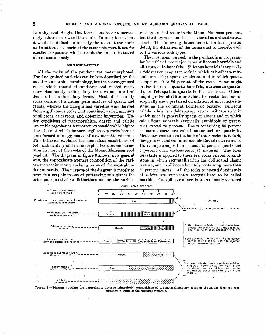
All the rocks of the pendant are metamorphosed. The fin~-grained varieties can be best d~cribed by the use of metamorphic termino~ogy, but the coarse-grained rocks, which consist of san4stone and related rocks, show dominantly sedimentary textures and are best described in sed,imentary terms. Most of the sandy rocks consist of a rather pure mixture of quartz and calcite, whereas the fine-grained varieties were q,erived from argillaceous rocks that contained varied amounts of siliceous, calcareous, and dolomitic •impurities. Under conditions of metamorphism, quartz and calcite are stable together at temperatures considerably higher than those at which impure argillaceous rocks become transformed into aggregates of metamorphic minerals. This behavior explains the anomalou$ coexistence of both sedimentary and metamorphic textures and structures in most of the rocks of the Mount Morrison roof pendant. The diagram_ in figure 3 shows, in a general way, the approximate average composition of the various metasedimentary rocks in terms of the most abundant minerals~ The purpose of the diagram is merely to provide a graphic means of portraying. at a glance the principal quantitative distinctions among the various
rock types that occur in the Mount Morrison pendant, but the diagram should not be viewed as a classification chart. The following discussion sets forth, in greater detail, the definition of the terms used to describe each of the various rock types.
The most common rock in the pendant is microgranul~r hornfels of two major types, siliceous hornfels and siliceous calc-hornfels. Siliceous hornfels is typically a feldspar-mica-quartz rock in which calc-silicate minerals are either sparse or absent, and in which quartz comprises 40 to· 80 percent of the rock. Some might prefe1; the. terms quartz hornfels, micaceous quartzite, or feldspathic quartzite for this rock. Others might prefer phyllite or schist for rocks that microscopically show preferred orientation of mica, notwithstanding the dominant hornfelsic texture. Siliceous calc-hornfels is a feldspar-quartz-calc-silicate rock in which mica is generally sparse or absent and in which
. calc-silicate. _minerals (typically amphibOle or pyroxene) exceed 25 percent. Rocks containing 80 percent or more quartz are called metachert or quartzite. Metachert constitutes the bulk of these rocks; it is dark, fine-grained, and contains possible Radiolarian remains. Its average composition is about 95 percent quartz and 5 percent dark carbonaceous ( ~) material. The term quartzite is applied to those few rocks related to sandstone in which recrystallization has obliterated clastic texture, and to siliceous hornfels containing more than 80 percent quartz. All the rocks composed dominantly of calcite are ·sufficiently recrystallized to be called marble. Calc-~ilicate minerals are commonly scattered
CUMULATIVE PERCENT
METAMORPHIC ROCK (and parent rock)
I I I I I I I 0 10 20 30 40 50 60 70 80 90 100
Quartz sandstone, quartzite, and metachert ___ i (sandstone and chert)
Siliceous calc-hornfels 1
/, ·,-1 1 V, . 1 . , / , 1 , 1 -roth potassium feldspar and plagioclase;
(limy and dolomitic siltstone) - - ---- 71L_.::::O..:-:_:ua:::.rt~z-.J:F=~F:§el~d~sp~a~r .=:!3::.'~1 -2:Am~~,>~h~ip~o~le.2::o~r ~Py~r~ox~e~he:L-:..::1~ garnet, calctte, and wollastomte com.mon · = _,,,, ,_.-_.,/,-,,~,"'- inpyroxene-bearing·rocks '
' . .
Calcareous quartz sandstone 1 ['\\_ \. \." '" "· \\-\.\. ~ (limy sandstone) - - - - - - - '-· _ ___;_ ___ o_ua_rt_z _.___ __ ____.!.'\._, ~~"'-"' "-"-~ "-"-_,._ ,..lo..c~_,a,__!c.:...:!t~..._,::..._,'-\ "-__,\ "-~ "-......., 'i
(li~=~~~~e>--- _;_ ------~~~~0~~~~~~~
Scattered silicate zones or pods (tremolite, diopside, wollastonite) common in the sandstone; somewhat less common in the marble; associated with chert in the marble
Fmu8m. 3.---'Diagram showing the approximate average mineralogic compositions "of the metasedimentary rocks of the Mount Morrison roof ; . pendant in terms o~ the essenti.e,l minerals. ·.
METASEDIMENTARY ROCKS OF PALEOZOIC AGE 9
through the marble but typically constitute less than 20 percent of the rock. Rocks that contain 50 percent or 1nore mica n,re called slate if cleavage is well-developed and pelitic hornfels if it is not. The terms phyllite and schist are used to describe rocks with megascopicnJly visible preferred orientation: phyllite has a sheen on clea, vage faces resulting from the mass e:ffeet of many oriented mica flakes; schist is generally coarser grained and discrete mica flakes a,re visible. .
Varietnl modifiers are used occasionally in the discussion of siliceous hornfels and siliceous calc-hornfels to mnphn,size minor constituents that compose at least 10 percent of the rock and are listed -in the order of increasing abundance;' for example, tremolite-biotite-
. siliceous hornfels (tremolite, 15 percent; biotite, 20 percent; and quartz, 65 percent).
Sandstone includes all rocks with conspicuous megascopic clastic texture. The clastic grains are sand size ( > 0.06 mm) and consist almost exclusively of quartz with only scattered grains of pot.assium feldspar. and plagioclase. In'cluded as subdivisions of sandstone are quartz sandstone, calcareous quartz sandstone, and sandy marble. The first two types contain more than 50 percent clastic grains, whereas the third contains less tlu\n 50 percent clastic grains. According to Grout (1932, P· 291), all these rocks would be classed as either quartz sandstone or calcerous quartz sandstone depending on the amount of the calcareous fraction. According to Pettijohn (1949, p. 237, 290), the first two types probably would be calcareous orthoquartzite and o~thoquartzite, respectively, a_nd the third would be ,cla~ as arenaceous limestone ... Grout's terminology has ~een followed as it seems to better emphasize the sandy tex·~ tur.e of these rocks. Calcite, entirely recrystallized, is ~tn important fraction of most of the sandstone; 'vhere it comprises less than 50 percent of the rocks the term c~lcareous quartz sand.stone is used, and. 'vhere it c~omprises more than 50 percent. the rock is called a sandy marble. In many places the calcareous quartz sandstone and sandy marble contain abundant calc-silicate mi.nentls in irregular zones and pods. The typical silicate minerals are wollastonite, diopside, and tremo.; lite. Wollastonite and diopside commonly· occur together, but neither occurs with tremolite, supporting the associations described by Bowen ( 1940) -that is, tremolite cannot coexist ·in eq~ilibrium with wollasto11ite. Inasmuch as tremolite· is a common mineral thro11ghout the pendant, the local presence· of wollastonite indicates localities where temperatures were n.bove those that generally prevailed during metamorphism .. The presence of tremolite and diopside in the calcareous rocks indicates that they were probably originuJly dolomitic.
Quantitative terms used to describe the bedding and the ~quivalent splitting properties follow the classification suggested by lVlcl(ee and 'Veir (1953): very thick bedded, greater than 120 em ( 4 feet) ; thick-bedded (blocky), 60 to 120 em (2 to 4 feet); thin-:bedded (slab by), 5 to 60 em ( 2 inches· to 2. feet) ; very thin bedded ( flaggy), 1 to 5 em ( 0.5 inch to 2 inches) ; la~tinated (shaly), 2 mm to 1 em (0.08 to 0.5 inch); and thinly laminated (papery), less than2 mm ( 0.08 inch) .. In addition, massive has been used (not according . .to the above classification) to describe hornfels ":ith._:p.o visible bedding.
METAMORPHISM
The principal mineral assemblages that ·compose the metamorphic rocks are in general typical of the hornblende hornfels facies of Turner ( Fyfe, Turner, and Verhoogen, 1958, p. 205-211). The common assemblages are quartz, mica, potassium feldspar., .and plagioclase in the aluminous rocks, and quartz, plagioclase, di~pside, tremolite, grossularite, and wollastonite in the calcic rocks. The presence of considerable epidote in the calcic rocks and the occurrence of · tremolite or actinolite instead of aluminous hornblende ·indicate that the metamorphic grade is probably, low in the horn~ blende hornfels facies and may reflect a grade transitional ·between the hornblende hornfels and the albiteepidot~ hornfels facies (Fyfe, Turner, and Verhoogen, 1958, p. 204, 205). The only evidence of metamorphic zoning in the pendant consists of wollastonite distributed sporadically through quartz-calcite rocks and quartz-calcite-pyroxene rocks. The wollastonite localities bear no systematic relation to granitic contacts and apparently reflect "hot spots"-tl_lat is, zones where permeability was probably high during metamorphism, perhaps as a result of local fracturing, thereby providing, a means for more effective transfer of heat. Along granitic contacts, where the effects of highest temperature might be expected, textures are locally coarser than elsewhere and in a few places wollastonite has developed in rocks of the appropriate composition. However, no consistent relationship between wollastonite and proximity with the contact was recognized. The mineral assemblages of the granitic rocks correspond to the grade of the adjacent metamorphic rocks. The typical assemblages of the granitic rocks, biotite-hornblendeplagioclase-microcline-quartz and less commonly muscovite-biotite-plagioclase-microcline-quartz, are. also common assemblages of the hornblende hornfel~ facies.
PETROGRAPHY
About 90 thin sections of the metasedimentary. rocks were examined with a petrographic microscope, and

10 GEOLOGY .AND MTh~RAL DEPOSITS,, MOUNT MORRISON QUADRANGLE, CALIF.
the mineral percentages for each specimen were estimated. Mineral percentages for .some of the coarser grained rocks were obtained by the use of a micrometer stage adapted for point counting.
Plagioclase and potassimn feldspar are rarely twinned and were distinguished from each other and from quartz on the basis of relative relief in thin section; composition of the plagioclase was not determined. The micas are either muscovite or members of the biotite group ('Vinchell, 1951, p. 373) and in the finest grained rocks were distinguished on the basis of the presence or absence of pleochroism. With a few exceptions, minerals. of the biotitB group show weak, pale-brown pleochroism and are probably members of the phlogopite-eastonite series. The amphiboles are subspecies of "common hornblende" (Winchell, 1951, p. 425) and were identified as either tremolite or actinolite on the basis of the presence or absence of weak palegreen pleochroism. The pyroxenes are subspecies of polyaugite (Winchell, 1951, p. 404) and are probably diopside. Opaq.ue constituents consist of metallic minerals and 0arbonaceous material identified by their appearance in reflected light.
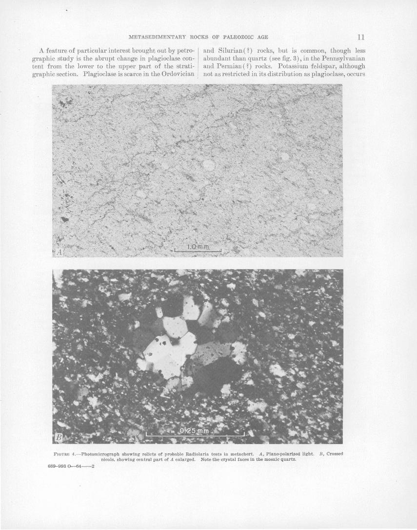
Several specimens of siliceous calc-hornfels, siliceous hornfels, and metachert contain discrete round grains, composed of a mosaic of quartz; these· may be Radiolaria tests (fig. 4). The grains range in size from 'about 0.02 mm to 0.2 mm and are most easily recognized in plain light; the absence of opaque material in the grains helps distinguish them from the matrix of the rock, which is commonly clouded with tiny opaque grains. The roundness of n1ost of the grains suggests that there has been little or no quartz overgrowth since deposition.
SILICEOUS HORNFEIJS
FIELD DESCRIPITION
Siliceous hornfels is the most abundant of the metasedimentary rocks and occurs in varied amounts in most of the formations. It is commonly well bedded and range!S from thinly laminated· to very thi~k bedded. From a distance the rock appears dark gray, but locally it weathers dark reddish brown from the oxidation of disseminated pyrite. On fresh surfaces its color ranges from light to dark gray. Layering generally is distinct on weathered surfaces but obscure on fresh surfaces. Biotite-rich varieties can genel'ally be distinguished by a weak reddish-brown tint on fresh surfaces.
The texture is typically hornfelsic, but at a few localities near granitic contacts it becomes phyllitic or schistose. Siliceous calc-hornfels is interbedded with siliceous hornfels in many places and where the siliceous calc-hornfels is dark colored the two types can rarely be distinguished in the field. Pelitic hornfels, meta-
chert; and siliceous hornfels also may be locally difficult to distinguish in. the field.
Because of its wide distribution, siliceous hornfels can oo found in almost all major outcrops of the metasedimentary rocks. Particularly . good exposures are accessible along t'he Laurel Lakes trail and along. both sides of McGee Creek for the entire length of its course through the metasedimentary rocks.
MICROSCOPIC DESCRIPTION
Quartz, mica, feldspar, and opaque material, in order of decreasing abundance, are the principal constitueJ:?.tS of the siliceous hornfels. The dominant texture of the rock is granoblastic, although locally the mica shows well-defined planar orientation. Andalusite occurs at several localities and may constitute as much as 20 percent of the rock. Relict clastic texture is commonly preserved and is characterized by subangular to subround quartz grains set in a fine-grained mosaic of quartz, potassium feldspar, mica, and carbonaceous(~) material. The grain-size averages about 0.03 mm and ranges from less than 0.01 mm to as much as 3.7 mm. The larger grains generally are either clastic fragments (0.1 min to 0.2 mm) or porphyroblasts of andalusite or mica. Except for large porphyroblasts the texture is
· typically seriate. The . accessory minerals include hematite, pyrite, sphene, tourmaline, apatite, zircon ( ~), clinozoisite, zoisite( ~),and garnet, in the general order of decreasing abundance.
Thin sections of many apparently massive hand specimens show layering that is interpreted as bedding; graded bedding was also recognized in a few thin sections. Layers that are megascopically visible are distinguished chiefly by differences in color value; under the microscope, they appea.r to be the result of a relative abundance of opaque materials or biotite, although the opaque materials generally predominate. Locally the light-colored layers are coarsest, show evidence of greater recrystallization, and, unlike adjacent layers, contain no recognizable clastic fragments. These characteristics suggest that the layering has been formed or accentuated by metamorphism. Generally, however, the layers appear to be primary. A spotted texture occurs at several localities with spots that range in diameter from a few tenths of a millimeter to as much as 15 mm and that are scattered heterogeneously throughout the rock independent of bedding; the spots consist of aggregates of mica flakes which are commonly intergrown with hematite. In about half the thin sections the mica shows well-defined planar orientation, although megascopically most ·of the rocks appear to be structureless.
METASEDIMENTARY ROCKS OF PALEOZOIC AGE 11
A feature of particular interest brought out by petrographic study is the abrupt change in plagioclase content from the lower to the upper part of the stratigraphic section. Plagioclase is scarce in the Ordovician
and Silurian ( ? ) rocks, but is common, though less abundant than quartz (see fig. 3), in the Pennsylvanian and Permian(?) rocks. Potassium feldspar, although not as restricted in its distribution as plagioclase, occurs
FIGURE 4.-Photomicrograph showing relicts of probable Radiolaria tests in metachert. A, Plane-polarized light. B, Crossed nicols, showing central part of A enlarged. Note tbe crystal fac.es in tihe mosaic quartz.
689-993 0-64--2
12 GEOLOGY AND MINERAL DEPOSITS, MOUNT MORRISON QUADRANGLE, CALIF.
most commonly in plagioclase-free rocks-hence, in rocks o£ Ordovician and Silurian(?) age. This distribution o£ the :feldspars suggests that the younger rocks were originally more calcic and perhaps somewhat less potassic than the older rocks. The parent sediments :from which the siliceous hornfels :formed were proba;bly carbonaceous mudstone or siltstone with some interlaminated shale.
A chemical analysis o£ a specimen :from the Mildred Lake :formation (table 2) bears out the quartz-rich nature o£ the siliceous hornfels. From thin-section examination the rock was estimated to contain 60 percent quartz and 40 percent biotite. Because o£ the extremely fine-grained texture (about 0.04 mm) o£ the rock, a chemical analysis was needed to determine whether any substantial part o£ the material thought to be quartz, might actually be andesine. The analysis seems to bear out the petrographic observations, for i£ 60 percent of quartz, as estimated from the thin section, is subtracted from the analysis, the remainder fits ape proximately the analysis of biotite from gneiss of the Sierra Nevada (Turner, 1899, p. 295) but leaves an excess of Al203 .and CaO. The small amount of Na20 present in the rock limits the maximum possi:ble amount of andesine (An40 ) ·to 10 percent; a slight excess of Al203 and CaO still remains, probably as a result of error in assumed compositions or because of unidentified material occult in the matrix of the rock.
TABLE 2.-Chemical analysis ot siliceous hornfels
[Analysis of specimen (field No. M-200, lab. No. 144078) by the rapid method (Shapiro and Brannock, 1956), in weight percent. Analysts: .K. E. White, P. L. D. Elmore, P. W. Scott, U.S. Geol. Survey. Specimen from NW'4SE'4 sec. 20, T. 4 S., R. 28 E.]
Si02 ------------------------------------------- 75A Al20s ----------------------------------------- 10.4 Fe.o. ----------------------------------------- .6 FeO ------------------------------------------ 3.2 MgO ------------------------------------------ 3. 3 CaO ------------------------------------------ 2.6 Na.o ----------------------------------------- . 45 K.o ------------------------------------------ 2. 5 Ti02 ------------------------------------------ .63 P.o.·------------------------------------------ . 12 MnO --~--------------------------------------- .04 H.o ------------------------------------------ . 10 co.------------------------------------------- . 05
Total ----------------------------------- 100
SILICEOUS CA;LC·HORNFELS
FIELD DESCRIPiriON
The typical siliceous calc-hornfels is microgranular, laminated to very thin bedded, and on weathered sur~ faces ranges widely in color from graY'ish black to light shades of gray with varied tints of yellow, red, and green. Exposures commonly have a conspicuous striped appearance owing to the contrast in alternately colored beds. Fresh unweathered rock surfaces, however, are typically darker shades of gray and show little or no contrast in color. Locally, these rocks cannot be dis-
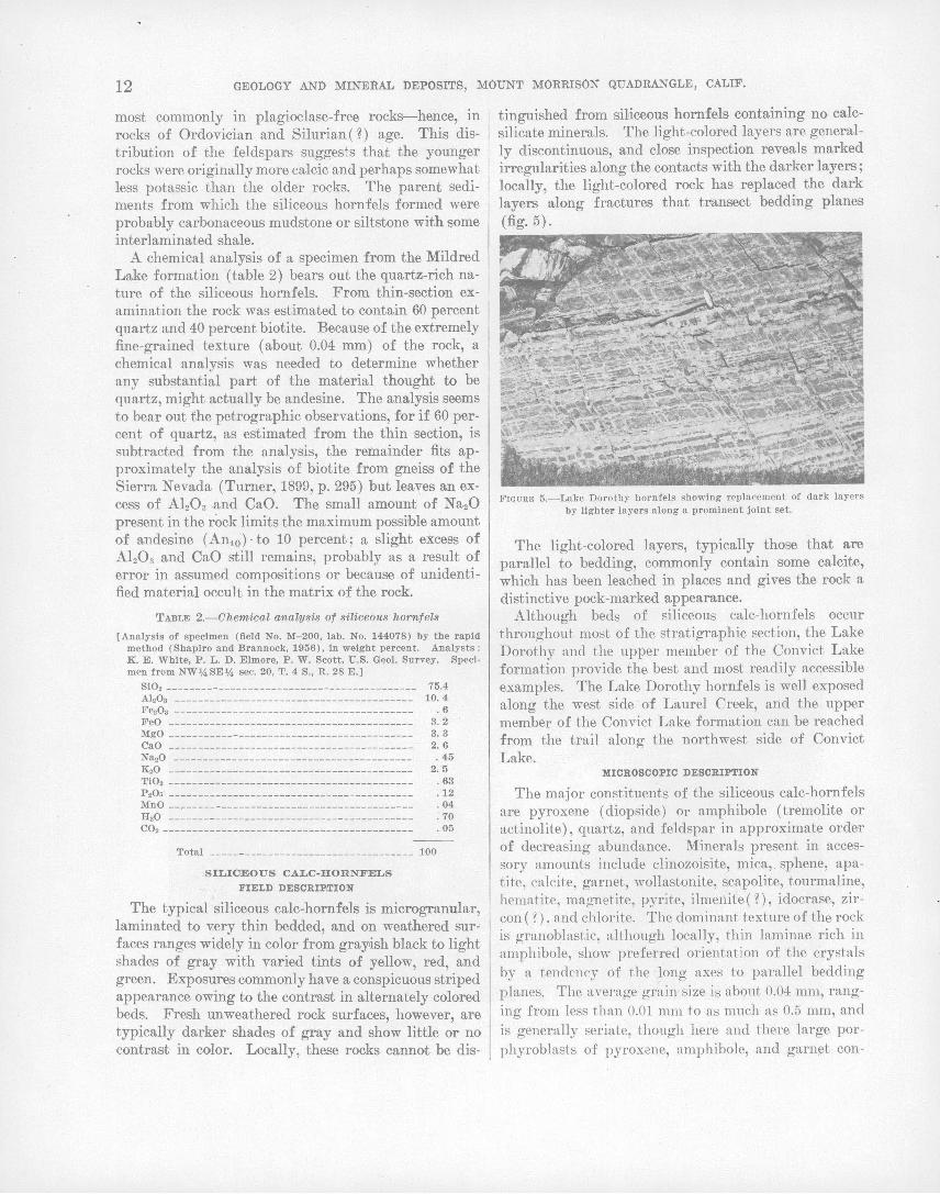
tinguished from siliceous hornfels containing no calcsilicate minerals. The light-colored layers are generally discontinuous, and close inspection reveals marked irregularities along the contacts with the darker layers; locally, the light-colored rock has replaced the dark layers along fractures that tvansect bedding planes (fig. 5).
FIGURE 5.-Lake Dorothy hornfels showing replacement of dark layers by lighter layers along a prominent joint set.
The light-colored layers, typically those that are parallel to bedding, commonly contain some calcite, which has been leached in places and gives the rock a distinctive pock-marked appearance.
Although beds of siliceous calc-hornfels occur throughout most of the stratigraphic section, the Lake Dorothy and the upper member of the Convict Lake formation provide the best and most readily accessible examples. The Lake Dorothy hornfels is well exposed along the west side · of Laurel Creek, and the upper member of the Convict Lake formation can be reached :from the trail along the northwest side of Convict Lake.
MICROSCOPIC DESCRIPTION
The major constituents of the siliceous calc-hornfels are pyroxene ( diopside) or amphibole ( tremolite or actinolite), quartz, and feldspar in approximate order of decreasing abundance. Minerals present in accessory amounts include clinozoisite, mica, . sphene, apatite, calcite, garnet, wollastonite, scapolite, tourmaline, hematite, magnetite, pyrite, ilmenite(?), idocrase, zircon ( ? ) , and chlorite. The dominant texture of the rock is granoblast.ic, although locally, thin laminae rich in amphibole, show preferred orientation of the crystals by a tendc·ncy of the long axes to parallel bedding planes. The average grain size is about 0.04 mm, ranging from less than 0.01 mm to as much as 0.5 mm, and is generally seriate, though here and there large porphyroblasts of pyroxene, amphibole, and garnet con-

.METASEDIMENTARY ROCKS OF PALEOZOIC AGE. 13
trast markedly with the dense matrix. Relict clastic texture is common and is characterized by suha.ngular ·quartz clasts set in a dense matrix of quart~ ~nd..
feldspar. Like the siliceous hornfels, the siliceous calc-hornfels
shows a general relationship between mineralogic composition and stratigraphic position. Rocks of Pennsylvaninn and Permian ( ~) age contain pyroxene ( diopside) as the typical ferromagnesian mineral and plagioclase as the most common feldspar, whereas rocks of Ordovician nnd Silurian ( ~) age are characterized by amphibole (tremolite or actinolite) and potassium feldspar. Inasmuch as the above mineral distribution seems related to stratigraphy and bears no recognizable geometric relation to granitic contacts, it is inferred that the difference in mineralogy reflects chemical differences between parent rocks. Rocks containing plagio~lase and pyroxene are almost certainly richer in CaO than rocks containing amphibole and potassium feldspar. .
Although the above relationship between mineralogic composition and stratigraphic position is a vaiid generalization, at many localities throughout the stratigraphic section amphibole and pyroxene occur in discrete layers in the same formation or even in the same thin section; the two minerals were not seen mixed together in a single layer, however. The layers are generally megascopically distinguished by a difference in color vnJue, which is largely due to the rel~tive abundance of opaque material. :Microscopic examination reveals many contrasting feat\nes associated with the color differen<:-e ;. these features are a.s follows:
Light-coZorcd ZaycrB
Coarser grained Clastic texture not recognized Pyroxene typical Ferromagnesian minerals
grouped Minor amount of opaque
materinl
Calcite common Scattered wollastonite and
garnet
Dat k-colored ZayerB
Finer grained Relict clastic texture Amphibole typical Ferromagnesian minerals
scattered Abundant minute opaque
grains of carbonaceous ( ? ) . material
Calcite apparently absent_ No wollastonite or garnet
The fn.cts that the lighter cqlored layers are coarser, show no relict clastic texture, and locally transect dark ln.yers, n.s shown by figure 5, suggest that these layers hn. ve probably sustained the gre.atest recrystalli~ation. They we.re probably more calc~treous tha.n the adjacent dQ.rl~er beds, as suggested by their selective cont~nt of the calcium-rich minerals pyroxene, calcite, w·ollastonite, and garnet. The grea;ter recrystallization of the light-colored layers may have resulted from the C02 liberated. from the. carbonate during metamorphism.
The C02 undoubtedly played an important part 'in the mobility demonstrated by the calcium.:.rich material as shown_ by figure 5. The opaque carbonaceous ( ~) material was probably expelled from the light-colored layers during recrystallization. The occurrence of wollastonite in several places probably reflects the presence of "hot spots" in the pendant during metamorphism, for in most places where quartz and calcite are together, they appear to be in complete equilibrium. In one wollastonite-bearing specimen, however, calcite and quartz also occur together, but both are partly replaced by wollastonite, suggesting that the temperature of this reaction was not maintained long enough to permit equilibrium to be established. ·
Chemical relations in the common replacement of dark-colored hornfels by light-colored hornfels, similar to that shown in figure 5, are shown by the chemical analyses of specimens M-193-x (dark) and M-193-y (light) shown in table 3. Specimen M-193.,was chosen because it shows the replacement particularly well both megascopically and in thin section. The dark-colored hornfels ( x) was estimated to contain quartz, plagioclase, and amphibole (actinolite), in order of decreasing abundance, as well as a minor amount of- potassium feldspar. The requirements of the analysis are satisfied . by about 50 percent quartz, 30 percent plagioclase (labradorite), and 20 percent actinolite. The light-colored hornfels (y) was estimated to contain quartz, plagioclase, diopside, clinozoisite, and a minor amount of calcite in order of decreasing abundance. The requirements of the analysis are satisfied by 45 percent quartz, 30 percent plagioclase and clinozoisite, and 25 percent diopside. The chief chemical difference between x and y is in the amount of CaO in each, a difference predictable from the mode by the occurrence of actinolite in the dark hornfels in contrast to di.opside in the light-colore~ hornfels. The other chemical differences between x and y can also be predicted from the mode: the K20 in xis accounted for in the potassium feldspar; the low N a20 value in y is accounted for by clinozoisite, which substitutes for some of the plagioclase in x; and calcite in y accounts for the C02. The principal effect of the reaction between the dark and light hornfels is the ·replacement of actinolite by diopside and calcite, accompanied by the expulsion of opaque carbonaceous ( ~) material. There appears to be no w~y to determine how much of the light-colored hornfels has resulted from the replacement of dark hornfels. The process seems to involve at least local redistribution of CaO, which presumably originated in beds rich in CaO, for much of the replacement has progressed outward from bedding planes.
14 GEOLOGY AND MINERAL DEPOSITS, MOUNT MORRISON QUADRANGLE, CALIF.
TABLE 3.-Chemical analyses, in weight percent, of silicr-o1M calc-hornfels
[Analyses by the rapid-method (Shapiro and . Brannock, 1956). Analysts: K. E. White, P. L. D. Elmore, P. W. Scott]
Field and laboratory (in parenthesis) Nos.
M-186-b M-193-x M-193-y (144077) (144079) (144080)
Si02- ----------------------- ________ --- _______ ----- _ 64. 7 AhOa .. __ ------------------- ________ ------- _____ - __ - 12. 8 Fe20a ___________ ------- ________ ----- ____ ___ __ _____ __ . 4 FeO _____________________ ----- ________ ------------ __ 3. 2 MgO _ -------------- _______ ---------- __________
7___ _ 6. 9
CaO ------------------ ________ --------- _____ -------- 5. 9 Na2.0 .. ______ ---------------- ____________ ----------- . 63 K20 ______ ----------- __ ----------------------------- 3. 6 Ti02------------------------------------------------ , . 46 P206------- ----------------------------------------- . 20 MnO _______________ -------------------------------- . 12 H20----------------------- ------------------------- . 66 002. ----------------------------------------,------ <. 05
TotaL _________ ------------------------------_ 100
Specimen localities:
76.4 8.8 .7
1.6 3.1 5.1 1.1 1.4 . 56 .16 .04
. 49 < 05
100
75.9 7.4 .2
1.6 3.4 9. 5
100
.29
.06·
. 50
.18
.06
.20
.24
M -186-b. 800 ft. west of the summit of Mount Aggie. Convict Lake formatiop.. M-193-x. 400 ft, north of the easternmost Laurel Lake. Bloody Mountam
formation. · · M-193-y. 400 ft. north of the easternmost Laurel Lake. Bloody Mountain
formation.
A third specimen (M-186-b) was analyzed to obtain more information on the chemical composition of the
. siliceous calc-hornfels and· to provide a further check on the reliability of· estimated modes. The specimen was estimawd to contain about 30 percent quartz, 20 percent plagiodase, 50 percent amphibole, and a small amount of mica. ·- From the chemical analysis of M-186-b the oxides required to satisfy the modal proportions of 30 percent quartz and 20 percent plagioclase (andesine) are subtracted first. The remainder, with the exception of excess K20, when recomput~d to 100 percent falls ~approximately within the compositional range of a group of six hornblendes, whose analyses are given by ·Penfield and Stanley (1907, p. 39-49) as part of a general study of amphibole. The K20 excess can be accounted for, at least in part, by the presence of mica in the mode. The amount of N a20 in the analysis, which limits the amount of plagioclase, although not a precise check on the mode, indicates that the quantitative estimate of modal plagioclase is approximately correct.
METACHERT
FIELD DESCRIPil'ION
The metachert is microgranular, contains more than 80 percent quartz, and resembles siliceous hornfels in the field. Vitreous luster on fresh surfaces, however, distinguishes it from siliceous hornfels, which is typically dull on fresh surfaces. A-lthough generally dark colored, metachert is locally light to pinkish gray. It is widely distributed throughout the ·stratigraphic section but is most abundant in the older rocks. Typically, metachert occurs interbedded with or grada~ tional into siliceous hornfels and as inwrbeds in cal-
careous quartz sandstone; it occurs less abundantly in calcareous rocks as nodules and discontinuous lenses.
MICROSCOPIC DESCRIPTION
Typically, the rock is composed of a fine-grained granoblastic mosaic of quartz, which locally shows a moderate degree of preferred orientation. Accessory minerals include apatite, zoisite, chlorite, pyriw, sphene, clinozoisite, calcite, and opaque substances, both metallic and carbonaceous. The rock is commonly cut by a network of tiny veinlets containing a variety of minerals including quartz, which is generally coarser grained than the groundmass. Irregular patches of much coart38r grained quartz and one or more of the foregoing minerals were found in several thin sections . Relict clastic texture was found in only one rock. The high perc~ntage of quartz and the paucity of relicit clastic texture in these rocks as contrasted with the siliceo us hornfels suggest that they have formed from chert.
PELITIC HORNFELS AND SLATE
FIELD DESCRIPil'ION
Pelitic rocks 'are most abundant in ·the older for· mations and are scarce in beds stratigraphically above the sandstone and hornfels of Sevehah Cliff. They are most abundant in the Mount Aggie formation and -are common also in the rocks exposed on McGee Mouritain and south and east of McGee Creek. The most easily accessible exposure is in the Mount Aggie formation along the south side of Convict Lake. The rocks are typically !•aminated and form- partings -between more siliceous beds but locally are several feet thick. Dark gray to grayish black are the dominant colors although many outcrops are stained, by limonite, to various shades of brown. Prominent :andalusite porphyroblasts, as much as 2 em in length were found .at several localities. Another common feature is the occurence of abundant light-colored oblate aggregates, as much as ·a centimeter in length, composed of tiny mica flakes. 'Where the rocks are cleaved, the long and ·intermediate axes of the aggregates generally lie in the cleavage plane., Cleavage in slate is the basis for distinguishing it from pelitic hornfels. Pelitic hornfels and siliceous hornfels, which commonly resemble each other, can be distinguished by the relative ease with which they can be scratched with a knife-pelitic hornfels is the softer.
MICROSCOPIC DESCRIPTION
The pelitic hornfels and slate are distinguished microscopically from siliceous hornfels, which theyclosely resemble, somewhat arbitrarily on the basis of the abundance of mica. (See p. 89.) From the six t;hin. sections studied, two other differences are apparent: (1) the average grain size is smaller in the pelitic
METASEDIMENTARY ROCKS OF PALEOZOIC AGE 15
hornfels and slate (about 0.01 mm), although scattered mica porph.yroblasts as much as 0.5 mm in maximum dimension are common and (2) mica is typically well oriented. Bedding is common and is generally defined by the relative proportion of mioa and quartz and locally by concentrations of opaque carbonaceous material. In one thin section showing relict clastic texture, crude gradation of the grain size in certain layers suggests poor graded bedding. Common accessory minerals include hematite, magnetite or ilmenite, pyrite, zoisite, chlorite, and apatite.
Cordierite, a mineral commonly found in pelitic hornfels of the hornblende hornfels facies~ .was found in only one thin section and occurs as porphyrob]asts as much as 2.5 mm in maximum length. The cordierite is partly altered to mica, cplorite, and an unidentified isotropic mineral that ranges in color from straw yellow to colorless and has an index of refraction of 1.545. The following microscopic data were determined for· the cordierite: nl' = 1.573 ± 0.003 determined from immersion oils and -217=72° measured on universal stage. No cleavage was identified and thevmineral is practically free of inclusions. It is possible that cordierite is also present in the groundmass, but be~ause of the extreniely fine grain size it was identified only in "the rel~atively large porphyroblasts. In <?He rock biotite, muscovite, chlorite, and an unidentified isotropic substance form aggregates that are cleared of opaque carbonaceous materia] and a few show regular equant outlines suggesting t1hat in part, the mioa may be pseudomorphic ~tfter an earlier -formed mineral, possibly cordierite.
SANDSTONE
FIELD DESCRIMION
Rocks included under this heading consis~ chiefly of calcareous quartz sandstone, accompanied by lesser amounts of sandy mn,rble and quartz sandstone (p. 9.). Except for a few thin beds i]l t.he Bloody Mountain and Lake Dorothy formations the sandstone occurs exclusively in rocks of Ordovician and Silurian (?) age. The rocks show Jnegascopic clastic texture ~ind are very fine gt~ained to coarse grained. The sandstone. is generally light colored, and on aerial. photographs or when v.iewed from a distance the sfra.ta are .in marked contrast w.it:h the more abundant dark rocks of the penclnnt. The sandstone is typically extremely thick bedded and apparently structureless for many tens of feet stratigraphically. Bedding planes are typically ill defined, though distinct laminations and cross lmninations were found in a few places. Silicated zones ranging in maxhnum dimension from a few feet to several tens of feet occur at several localities in the calcareous quartz sandstone and consist of masses of tre-
molite or wollastonite. The wollastonite, as mentioned earlier, probably indicates "hot spots" in the pendant during n1etamorphism, for in most of the calcareous quartz sandstone and sandy marble, quartz and calcite appear to be in equilibrium. The tremolite-rich zones probably d'efine zones where the parent rock was dolo-mitic. -
Exposure of quartz sandstone and calcareous quartz sandstone of the Convict Lake and Mount Morrison
. formations, respectively, are readily accessible from trails that start at Convict Lake.
MICROSCOPIC DESCRIPTION
Microscopic examination of typical calcareous quartz sandstone and sandy marble shows well-rounded and well-sorted quartz grains, about 0.5 mm in diameter, in a matrix of recrystallized calcite, which has an average grain size of 0.1 mm or less (fig. 6). Grains of potassium~feldspar and plagioclase, generally less well rounded than the quartz, are common minor constitu·ents. Where mica is present it is interstitial to the clastic grains and typically forms thin films around them. Accessory minerals recognized in the sandstone group
· are clinozoisite, opaque material, garnet, apatite, chlorite, zoisite, zircon, sphene, pyrite, magnetite-ilmenite, hematite, and tremolite. Little evidence regarding the origin of the cal~ite was found, but one specimen contains several angular fragments, as much as a centimeter in maximum dimension composed of a mosaic of calcite crystals much finer grained than the calcite composing the matrix of the rock. These fragments may represent ·detrital fragments of finer grained limestone or fossil fragments, but an explanation for the disparity in grain size is lacking.
Where th~ calcareous rocks have been silicated, clastic texture is generally poorly preserved. This is demonstrated in figure 6 which shows wollastonite blades penetrating quartz g~ains, thereby destroying the original clastic texture. Diopside, potassium feldspar, and plagioclase are associated with wollastonite and q~artz, and all appear to be in equilibrium. Elsewhere 1n the silicated rock, calcite occurs in veinlets and was apparently introduced either at a late stage in the Inetamorphism or subsequent to it. 'fremolite typically forms rosettes and appears stable in the presence of both quartz and calcite. It is not found in association with either wollastonite or diopside.
In contrast to the ca.lcareous varieties, quartz sandstone shows poor preservation of clastic texture. The quartz rrrains where identified, a..re comparable in size
~ ' . to those in the calcareous sandstone, but many gratns show evidence of crushing. Some grains also show clear evidence of having increased to nearly twice their orig-
.............
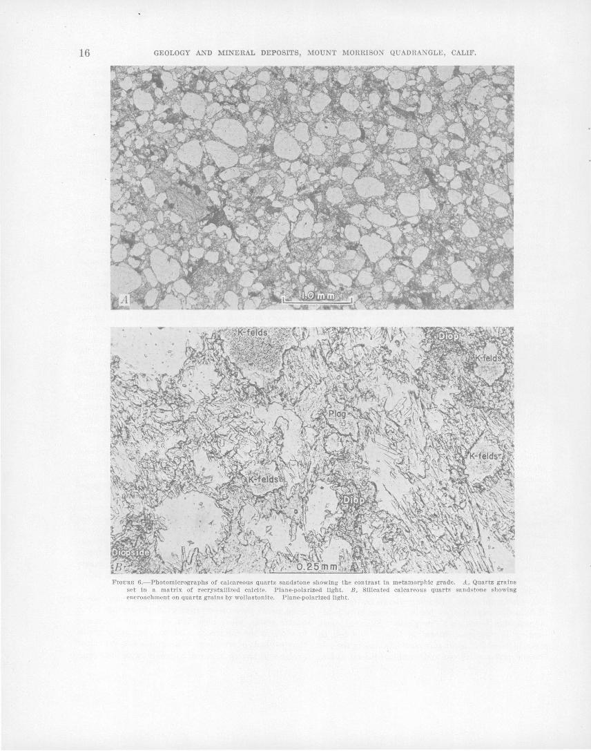
16 GEOLOGY AND MINERAL DEPOSITS, MOUNT MORRISON QUADRANGLE, CALIF.
FIGURE 6.- Photomlcrographs of calcareous quartz sandstone showing the contrast In metamorphic grade. A, Quartz grains set in a matrix of recrystallized calcite. Plane-polarized light. B, Silicated calcareous quartz sandstone showing encroachment on quartz grains by wollastonite. Plane-polarized light.
METASEDIMENTARY ROCKS OF PALEOZOIC AGE 17
inal size by the growth of a mantle around an original grain; such growth also effectively obscures primary texture. The. difference between the quartz sandstone and the calcareous quartz sandstone, in the preservation of clastic texture, is probably due to cushioning of the quartz grains by calcite in the calcareous varieties during deformation.
MARBLE
The Hilton Creek marble, l\{ount Baldwin marble, and the Mount Aggie forination and equivalent or older rocks contain more than 90 percent of the marble in the pendant. Thin interbeds of marble also occur locally in the Bloody Mountain, Mount Morrison, and Convict LaJ{e formations, but are quantitatively insignificant. Typical exposures of the marble-bearing formations are readily accessible at the following localities: ( 1) At the mouth of McGee Creek in the south wall of the canyon (Hilton Creek marble), (2) in the east wall of the canyon of Laurel Creek opposite the end of the. jeep trail (Mount Baldwin marble), (3) along the southeast side of Convict Lake (Mount Aggie formation).
The marble ranges in color from light-gray to dark bluisl~-gray, depending on the amount of recrystallization. Most marble is Jine grained, but recrystallized zones of coarse to very coarse grain occur here and there, and, at one locality in the Mount Baldwin marble, calcite crystals measuring 1 foot across were found. Relict bedding can generally be recognized in the dark less recrystn1lized marble, but all traces of bedding are gone in the light-colored strongly recrystallized rock. Fossils are best preserved in the darker colored marble. For example, in the l\{ount Baldwin marble small details of brachiopod casts and crinoid columnals are well preserved in dark-colored marble, whereas in adjacent Hght-colored and coarser grained marble, only the gross shapes are preserved. Chert commonly occurs as nodules, crude layers, or irregular lens-shaped masses several inches across, particularly in the Mount Baldwin marble.
Thin sections of the marble typically show a granobla.stic mosaic of subhedral to anhedral calcite crystals with minor amounts of the following: Diopside, tremolite, wollast.onite, scapolite, idocrase, gaq1et, opaque carbonaceous ·material, quartz in blunt lenses or detrital grains, a.nd opaque metallic minerals including pyrite, magnetite or ilmenite, and hematite. Calcite typically constitutes at least 80 percent of the marble except 'in local silicate zones. The silicate minerals comprising the minor fraction a.re generally scattered heterogeneously throughout .the rock, but locally they are in pods or thin discrete layers that probably reflect· siliceous dolomitic, or argillaceous interbeds ·in t11e original sedi~
ment. Sporadic distribution of wollastonite, in addition to indicating siliceous impuritJies in the marble, also indicates "hot spots" in the pendant during metamorphism. An occurrence of brucite in the l\{ount Aggie formation indicates that the parent rock there was pure magnesian limestone or dolomite. Skarn minerals have formed locally in the calcareous rocks near contacts with intrusive rocks. In most places the mineral assemblage reflects the addition of material, chiefly silica and iron, and in that respect is unlike the silicate assemblage elsewhere in the calcareous rocks.
STRATIGRAPHY
l\{ajor fn,ults divide the Paleozoic section into three blocks, the McGee Mountain, Convict Lake, and Bloody Mountain blocks in order of decreasing age (fig. 2); the discussion of the stratigraphy follows this subdivision. Within the blocks the formations are generally conformable and are typically gradational over a few tens of feet. A discussion of the relation between blocks, including possible correlation of units, follows the description of the stratigraphic section. A generalized columnar section of the metasedimentary rocks of Paleozoic age is shown in pl. 2.
FORMATIONS OF TH.E MCGEE MOUNTAIN BLOCK
The formations of this block are exposed in an area where only a few geographic features have been named, thus limiting the number of geographic names that can be applied to rock units. Each lithologic unit is considered to have formational rank, but the only formally named unit is the Hilton Creek marble, which is stratigraphically the lowest forma.tion exposed.
HILTON CREEK MARBLE
The Hilton Creek marble of Ordovician ( ~) age crops out in three areally disconnected segments in the southeastern part of the quadrangle; the southernmost and largest segment is well exposed west of Hilton Creek, for which the formation is here named. This segment is exposed continuously for about 2 miles and if the two small probably correlative units north of McGee Creek are included, the total strike length of the formation is 31h miles. Granitic rocks intrude the marble at several places along the east side and .cut it off at both the north and south ends.
The maximum exposed thickness is south of McGee Creek where the formation is 1,500 feet thick. Faults bound the ·.formation both at top and 'bottom everywhere except near the southern end of the outcrop where the siliceou~ hornfels appe'ars to lie above the marble in normal depositional contact. The best place to see. the formation in nearly its total exposed thickness is
18 9EOLOGY AND MINERAL DEPOSITS, MOUNT MORRISON QUADRANGLE, CALIF.
along the south side of McGee Creek, here designated the type locality.
The formation consists dominantly of light-gray to dark-bluish-gray fine-grained marble. Scattered chert no{iules were found at one exposure, and beds of darkgray siliceous hornfels are locally intercalated with the marble. Silicated zones are common throughout the marble; light-colored siliceous calc-hornfels is locally intedayered and is particularly abundant north of McGee Creek.
SILICEOUS HORNFELS
The siliceous hornfels unit stratigraphically overlies the southernmost segment of the Hilton Creek marble and is ·exposed northward, from its contact with the granodiorite on the south, continuously fo~ about 2 miles. The relative inaccessibility of much of the outcrop area, un.fortunately has resulted in a poorer knowledge of this unit than of most of the others. Near its south end the unit ·appears conformable with both the underlying Hilton Creek marble and the overlying siliceous hornfels and marble unit. To the north, however, both the upper and lower contacts are faults, which converge at a point about a mile south of McGee Creek on Nevahbe Ridge and cut out the entire unit north of this point. The unit is as much as 1,500 feet thick near its south end where contacts with the 'adjacent formations appear undisturbed. Rocks composing the unit are chiefly dark-colored micaceous siliceous hornfels, slate, andalusite-bearing pelitic hornfels, and siliceous calc-hornfels, in · the probable order of decreasing abundance.
SILICEOUS HORNFELS AND MARBLE
The siliceous hornfels :and marble unit extends from the east side of McGee Mountain southward to the granodiorite contact and is the most extensive unit in the McGee Mountain block. Considerable folding and faulting within the formation, as well as faulting along the contacts with adjacent units, precludes an accurate determination of thickness. About 2,500 feet of nearly vertical and apparently homoclinal beds, exposed in the rugged and largely inaccessible canyon wall on the south side of McGee Creek, provide the best estimate of the maximum thickness.
The unit is comprised· chiefly of dark-gray biotitebearing siliceous hornfels, metachert, slate and pelitic hornfels-including minor amounts of andalusite:.bearing peliti~ h.ornfels, and interbedded lighter gray marble. Slate and marble are distributed rather uniformly through the unit south of McGee Creek. The slate commonly lies in layers a fraction of an inch to a few inches thick between beds of metachert a few inches to a few feet thick. North of McGee Creek, a marble lentil crops
out at about the middle of the formation and is shown sepa.rately on .plate 1. Slate and inetachert are ~uc.h less abundant north of McGee Creek where the unit IS
composed dominantly of siliceous horn~~ls. . . Graptolites wer~ found at two localities In slaty In
terbeds in exposures along the south wall of the canyon of McGee Creek (pl. 1) and were examined by R. J. Ross, Jr., ·and W. B. N. Berry (written communication, 1958), whose identifications are recorded below. Specimens from locality A [U.S.G.S. colln. D536(CO) ], the easternmost locality, yielded Didymograptus sp. ( extensiform type) and Tetragr.aptus pendens Ell.es, Lower Ordovician forms which may correlate With zones 5-6 of Upper Ar~nig and Lower Lla.nvin1, with zone 5 considered the most likely. About 200 feet stratigraphically west of locality A, outcrops at locality B [U.S .. G.S. coHn. D515 (CO)] yielded the following Middle Ordovician fonns : Orthograptus .calca'l'atus var. ~ Lapworth, Orthograptus sp.,'Glyptograptus cf. G. teretiw:wulus (llisinger), Glyptograptus euglyphus Lapworth, Olim,acograptu.s bicornis J. Hall. The possible range of this collection, is zones 9-11 of the Caradoc. An additional graptolite assemblage [U.S.G.S. colin. D516 (CO) J was collected from talus north of locality A and contains Tetragraptus frutico8us J. Hall, 3 and 4 branch forms, and Didymograptus cf. D. ensjensi8 Monsen, Lower Ordovician forms which represent zone 4 of the Arenig. The rocks are lithologically similar to the fossiliferous rocks at locality A and are presumed
. to have weathered from a similar stratigraphic horizon.
SLATE AND IM~RBLE
The slate and marble unit crops out on the south and east sides of McGee Mountain, where it stratigraphically ove.rlies the siliceous hornfels and marble unit. The slate and marble unit was not recognized south of McGee Creek and has probably been cut out by faults in that a~ea. From the southernmost exposure on McGee Mountain the unit extends northward in discontinuous exposure for 2 miles. It is probably no more than 500 feet thick, but considerable folding and faulting have resulted in a markedly irregular outcrop pattern, and in places the outcrop width is as much as 1,500 feet.
Dominant rock types in the unit are slate and pelitic hornfels, marble, and siliceous hornfels, with subordinate amounts of siliceous calc-hornfels and metachert. In gen~ral, the unit is thin bedded with local variation from very thin to very thick beds. ·The marble is light to dark gray, typically fine grained, a.nd locally sandy. The siliceous calc-hornfels is light gray, light greenish gray, or yellowish gray and is commonly interbe.dded with marble.

METASEDIMENTARY ROCKS OF PALEOZOIC AGE' 19
SLATE
The slate unit stratigraphically overlies the slate and marble unit and has virtually the same areal distribution. It is about 750 feet thick, except at ·a few places where it has apparently been thickened by folding.
The dominant rock types making up the unit are medium dark gray to grayish black thinly laminated to laminated pelitic hornfels and slate, siliceous hornfels, and metachert. Some layers of siliceous calc-hornfels and marble are interbedded but are considerably less abundant than the pelitic and siliceous rocks.
SANDSTONE
From the south flank of McGee Mountain, the sandstone unit extends northwestward in discontinuous exposure about 2% miles, terminating a little more than half a mile southeast of Convict Lake. The unit is probably about 1,500 feet thick, but because of extensive deformation this figure is at best a rough estimate; at one place the outcrop is nearly a mile wide. Correlation between outcrops is based largely on lithologic similarity but, because much of this terrane is covered with slope wash and till and is strongly deformed, correlation is tentative.
The dominant rock is medium-gray to medium darkgray fine7 to coarse-grained calcareous quartz sandstone. The quartz grains are well rounded and make' up 55 percent or more of the rock. The remainder is calcite sufficiently recrystallized to obliterate all clues as to its original nature. Bedding is commonly preserved in the sandstone, particularly in the somewhat finer grained varieties, and thin, wispy laminations suggest crossbeds locally.
Commonly interbedded in the sandstone are layers a fraction of an inch to several feet thick of medium-darkgray to grayish-black metachert, somewhat less abundant siliceous hornfels, and, locally, pelitic hornfels. These brittle beds are commonly brecciated and have completely lost their former identity as interlayers (fig. 7). Gradations from unbrecciated interlayers to jumbled breccia establishes the origin of the breccia as tectonic rather than sedimentary.
A lentil composed of medium-dark-gray to grayishblack metachert, slate, and siliceous hornfels crops out discontinuously on the gentle upland surface atop McGee Mountain. The lithologic types comprising the lentil are similar to those of the thin commonly brecciated interlayers that occur in the calcareous quartz sandstone.
Poorly preserved fossils were found at three localities in the formation (pl. 1), and were examined by R. J. Ross, Jr, and W. B. N. Berry (written communication, 1958), whose identifications and age determinations are given below. The southernmost locality, C, on the south
FIGURE 7.-Brecciated chert interlayers In calcareous quart~ sandstone on McGee Mountain.
slope of McGee Mountain [U.S.G.S. colin. D513 (CO)] yielded the following graptolites: Orthograptus cf. 0. c.aloarattl8 var. acutus Lap worth; Orthograptus sp.; Glyptograptus cf. G. teretiusculus Risinger; Glyptograptus cf. G. euglyphus Lapworth; Olimacograptus cf. 0. parvus J. Hall. This assemblage is of Middle Ordovician age and represents zones 9- 10 of the Caradoc, with zone 10 the more likely. A second locality, D, near the summit of McGee Mountain [U.S.G.S. colin. D534(CO) ], yielded Ortlwgraptus sp. and Olimacograptus parvus J. Hall, forms similar to those found at locality C. A third locality, E, on the north slope of McGee Mountain [U.S.G.S. colin. D535 (CO)], yielded Diplograptus ~ sp. and Glyptograptus ~ sp. Both are of probable Ordovician age, although they also occur in Silurian strata.
FORMATIONS OF THE CONVICT LAKE BLOCK
BUZZTAIL SPRING FORMATEON
The Buzztail Spring formation, here named for a spring on the north side of McGee Creek, is discontinuously exposed over a strike length of about 4 miles. It is in fault contact with older rocks on the east, but its upper contact with the Mount Aggie formation is depositional. Its thickness cannot be accurately determined, because the base is not exposed and also because of much internal deformation, particularly south of McGee Creek where the rocks are most extensively folded and sheared. At the type locality north of McGee Creek the rocks are less deformed and the section exposed between the fault on the east and the Mount Aggie formation on the west is probably on the order of 2,000 to 2,500 feet thick; south of the creek the outcrop is about a mile wide.
The formation is composed of interlayered generally dark colored pelitic hornfels and slate, siliceous horn-
20 GEOLOGY AND MINERAL DEPOSITS,· MOUNT MORRISON QUADRANGLE, CALIF.
fels, metachert, calcareous quartz sandstone, and marble, in beds typically ranging from a few inches to a few feet thick. South hf McGee Creek it is more calcareous and less pelitic than it is to the north. Mediumgray calcareous quartz s~ndstone is widely distributed throughout the formation in thin to thick interbeds, but is quantitatively important only in a light-colored calcareous quartz sandstone member that crops out near the top of the formation. These beds are nevertheless more abundant in the Buzztail Spring formation than in the overlying Mount Aggie formation to the west, and they serve as the principal distinction between these otherwise similar formations. A further but less prominent distinction is a paucity of siliceous calc-hornfels in the Buzztail Spring relative to the Mount Aggie. The calcareous quartz sandstone member is interpreted as a formerly continuous stratigraphic unit that has been deformed by faulting and tight folding. South of McGee Creek the member has been thickened by folding, but· to the north, where it is less deformed, it has a maximum thickness of about 500 feet. At its southernmost extent the unit appears to grade laterally within a short distance into the typical marble, pelitic and siliceous hornfels sequence. The Buzztail Spring formation is of Ordovician ( ? ) age.
MOUNT AGGIE FORMATION
The Mount Aggie formation of Ordovician ( ? ) age is exposed fairly continuously from the ridge north of Convict Lake southeastward to its contact against granodiorite, a distance of about 61h miles. It is here named for, and forms the east slope of, Mount Aggie, a prominent peak about llh miles southeast of Mount Morrison. The type locality is designated as the north shore of Convict Lake, where an unfaulted section about 2,500 feet thick is well exposed above a lateral moraine. Although the formation may be thicker to the south, as suggested by greater outcrop width, the rocks there are considerably more. deformed, hence thickness estimates are less· reliable. East of Mount Aggie the formation may be as much as 5,000 feet thick, but two prominent strike faults cut the rocks in that area, and the amount of displacement along them is not known.
From the type locality south to J\1ount Aggie the formation is a distinctive assemblage of interbedded very thin to thick-bedded slate and marble. The slate is medium dark gray to grayish black, extremely fine grained, and commonly splits into shaly to slab by fragments. The marble is medium bluish gray to medium dark gray, fine grained, and forms layers a few inches to a few feet thick that make up about a third of the formation. Southeast of l\1ount Aggie the formation shows a general progressive southward increase in sandstone content and an accompanying decrease in slate
and marble content. On Mount Aggie the dark-colored rocks are more siliceous and less fissile than to the north and beds of calcareous quartz sandstone 5 to 40 feet thick are exposed locally in the southeast slope of th~ mountain. Southwest of Horsetail Falls in the upper part of the formation, a lentil of calcareous quartz sandstone 1,000 feet thick is exposed over a strike length of three-quarters of a mile. East of the lentil the formation consists of interbedded sandstone, siliceous hornfels and slate, and marble is significantly less abun- · dant than at the type locality near Convict Lake. Southeast of IIorsetail Falls, the formation consists of interbedded ]aminated dark-gray siliceous hornfels, light-gray siliceous calc-hornfels, fine-grained sandy marble, and calcareous quartz sandstone. In the thicker bedded parts of the section, siliceous hornfels predominates over pelitic hornfels and slate.
The general southward inc.rease in sandstone content and accompanying decrease in slate and marble content results in a marked lithologic similarity to the .underlying Buzztail Spring formation; . hence, the contact is poorly defined, particularly in the southernmost part. East of Mount Aggie the formation is identified according to relative abundanc~ of interbedded calcareous quartz sandstone, these beds being most common in the Buzztail Spring. Farther south siliceous calc-hornfels is more abundant in the Mount Aggie formation than in the Buzztail Spring.
CONVICT LAKE FORMATION
The type locality of the here named Convict Lake formation of Middle Ordovician (Caradoc) age is near the west end of Convict Lake where the rocks are well exposed ·and easily accessible above moraine along the north shore. From the type locality the "formation is exposed along the strike for a mile to the north and discontinuously for 4 miles to the ~outh.
Northwest of Convict Lake where structural deformation is least, the formation is about 1,500 feet thick and is divisible into two ·members, an upper siliceous calc-hornfels member about 300 feet thick and a lower siliceous hornfels member about 1,200 feet thick. The formation is also about 1,500 feet thick near its southernmost exposure, but there a. tongue of granodiorite obliterates the upper stratigraphic contact. East of Mount Morrison, the upper 1,000 feet of the lower member are cut out by a fault which intersects the beds at a small angle. The contaet with the underlying Mount Aggie formation is conformable. Near Convict Lake the contact is placed at the base of the lowest prominent quartz sandstone unit and is quite sharp. About llh miles south of Convict Lake the quartz sandstone lenses out and the contact is gradational over a strati-
METASEDIMENTARY ROCKS OF PALEOZOIC AGE 21
graphic interval of as much as 200 feet. There the contact is drawn on the basis of the abundance of thin marble beds which are sparse in the Convict Lake formation and abundant in the Mount Aggie formation.
LOWER SILICEOUS HORNFELS MEMBER
The lower member of the formation consists chiefly of microgranuln.r, thinly laminated to very thick bedded, dark-gray to medium-dark-gray carbonaceous siliceous hornfels, with lesser amounts of slate, metachert, quartz sandstone, and marble. The slate commonly occurs as thin laminae in the silceous hornfels. Locally the slate is andalusite bearing along the ridge northwest of Convict Lake, with andalusite porphyroblasts as long as 2 em. Discontinuous thin beds of dark-gray to mediumdark-gray marble are locally interbedded with the siliceous ~ornfels. ·Very fine to fine-grained nearly pure quartz sandstone in beds a few feet to more than a hundred feet thick are common in the formation, particularly near Convict Lake. Fresh surfaces of the 'quartz sandstone are medium dark gray to light gray, although weathered surfaces typically show various shades of brown limonite stain. Thick relatively pu~ ·quartz sandstone beds interbedded with a few thin beds of marble distinguish the lower member of the Convict Lake formation from the underlying Mount Aggie formation.
Lateral lithologic change is shown by progressive southward decrease in the slate and quartz sandstone content and an accompanying increase in the amphibole content of the siliceous hornfels. Microscopic examination shows that the amphibole content of some. of the rocks near Horsetail Falls is high enough to classify them as siliceous calc-hornfels, although they are megascopically indistinguishable from typical mica-bearing siliceous hornfels to the north.
The parent rocks were probably shale or mudstone containing var-ied proportions of silica and argillaceous material interbedded with subordinate amounts of sandstone and a minor amount of limestone. The sandstone beds probably lensed out to the south, whereas the silica component of the mudstone increased in the same direction with a parallel decrease in the clay fraction.
UPPER SILICEOUS CALC-HORNFELS MEMBER
The upper member is homogeneous and consists of thinly laminated to very thin bedded, .microgranular siliceous calc-hornfels. The layers range in color from grayish black through olive gray to grayish orange or very pale orange. In some places the lighter colored rock appears to have formed from the darker rock by the removal of minute particles of carbonaceous ( ? ) tnaterial selectively from certain beds. The fact that
such removal is a secondary process is demonstrated by cleared zones which are parallel to crosscutting fractures. In composition the rock is dominantly siliceous calc-hornfels consisting of as much as 85 percent ferromagnesian minerals. It is fairly common for this rock to grade locally into siliceous hornfels containing a subordinate ·amount of ferromagnesian minerals.
FOSSILS AND AGE
An assemblage of well-preserved graptolites was collected from an outcrop of fissile slate in the lower member just south of the west end of Convict Lake (pl. 1, locality F). R.. J. Ross, Jr., and W. B. N. Berry (written communication, 1958) have identified the following forms [U.S.G.S. colin. D514(co)]: Orthograptus cf. 0. calcaratus var. acutus Lapworth, O'rthograptus sp., Glyptograptus? sp., Olim,acograptus bicornis J. Hall, (Jlimacog1·aptus cf. 0. bicornis var. 0. tridentatus Lapworth, Glmuwgraptus hincksii? Hopkinson, H allograptus mucr·onatus? ,J. Hall, 'and DicranograpfiUJ8 nicholsoni var. D. parvangulus Gurley. They state that the collection is of Middle Ordovician age and represents zones 9-10 of the Caradoc, with zone 10 favored.
MOUNT MORRISON SANDS/l'ONE
The type locality of the Mount Morrison sandstone of Ordovician or Silurian ( ? ) age is in the easily accessible low ridges immediately west of Convict Lake; the formation is well exposed on the summit and east flank of l\1ount Morrison for which it is here named, but it cannot be easily reached there. The formation is discontinuously exposed along strike for 5 miles-from its northernmost exposure, 1lj2 miles northwest of Convict Lake, southeast to its termi~ation against granodiorite half a mile northeast of Mount Baldwin. It is cut midway along its exposed length by the northeast branch of the L.aurel-Convict fault; the southern segment is displaced southeast 2lj2 miles. The formation ranges in thickness from about 1,000 feet northwest of Convict Lake to about 1,800 feet near the south end of the long moraine-filled cirque south of Convict Lake. The contact with the underlying Convict Lake formation is conformable and is generally sharp or gradational over a few feet.
The formation is composed chiefly of fine- to medium-grained calcareous quartz· sandstone that ranges in color from white to medium dark gray with the lighter shades predominating. Near the center of the formation, both northwest of Convict Lake and in the thick part along the west side of the long cirque south of Convict Lake, 200 to 300 feet of microgranular laminated siliceous hornfels, ·marble, and siliceous calc-hornfels are exposed. In ge11eral the sandstone is very thick bedded or massive, although locally it is laminated. At
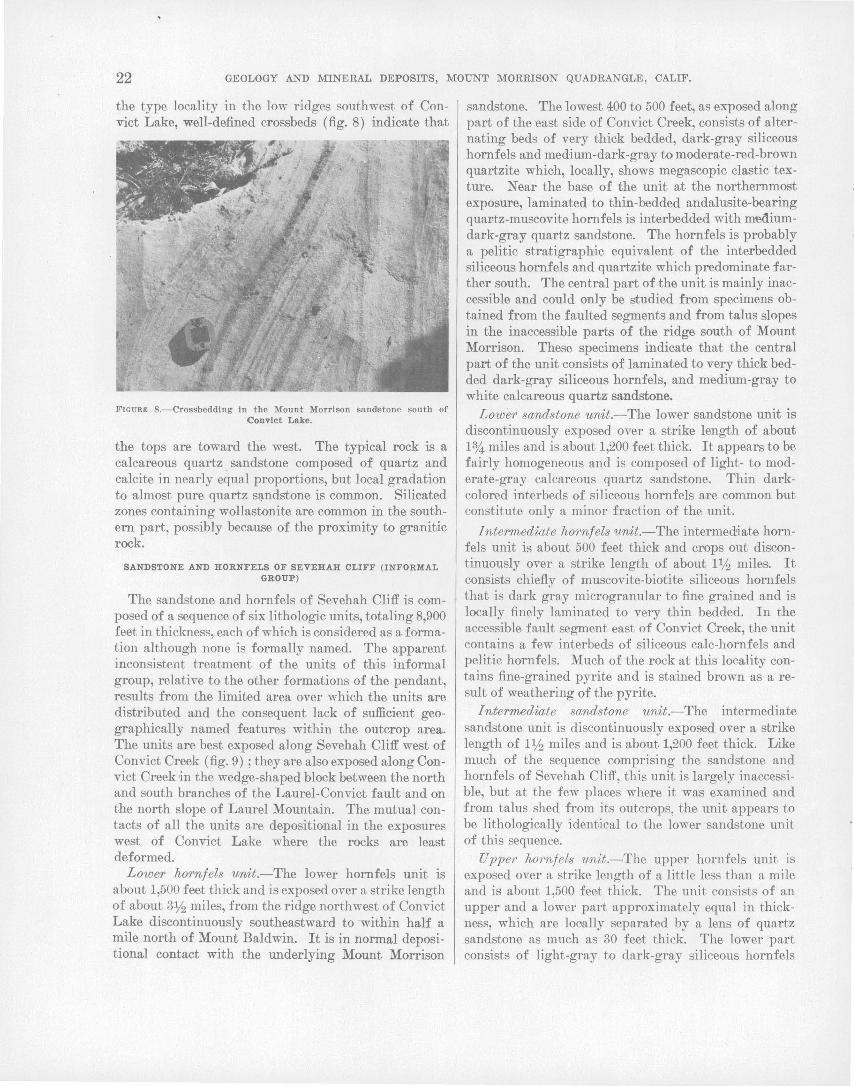
22 GEOLOGY AND MINERAL DEPOSITS, MOUNT MORRISON QUADRANGLE, CALIF.
the type locality in the low ridges southwest of Convict Lake, well-defined cross beds (fig. 8) indicate that
FIGURI!l 8.-Crossbeddlng In the Mount Morrison sandstone south of Convict Lake.
the tops are toward the west. The typical rock is a calcareous quartz sandstone composed of quartz and calcite in nearly ~ual proportions, but local gradation to almost pure quartz s~ndstone is common. Silicated zones containing wollastonite are common in the southern part, possibly because of the proximity to granitic rock.
SANDSTONE AND HORNFELS OF SEVEHAH CLIFF (INFORMAL GROUP)
The sandstone and hornfels of Sevehah Cliff is composed of a sequence of six lithologic units, totaling 8,900 feet in thickness, each of which is considered as a formation although none is formally named. The apparent inconsistent treatment of the units of this informal group, relative to the other formations of the pendant, results from the limited area over which the units are distributed and the consequent lack of sufficient geographically named features within the outcrop area. The units are· best exposed along Sevehah Cliff west o:f Convict Creek (fig. 9); they are also exposed along Convict Creek in the wedge-shaped block between the north and south branches of the Laurel-Convict fault and on the north slope of Laurel Mountain. The mutual contacts of all the units are depositional in the exposures west of Convict Lake where the rocks are least deformed.
Lower hornfels unit.-The lower hornfels unit is about 1,500 feet thick and is exposed over a strike length of about 31h miles, from the ridge northwest of Convict Lake discontinuously southeastward to -within hal:£ a mile north of Mount Baldwin. It is in normal depositional contact with the underlying Mount Morrison
sandstone. The lowest 400 to 500 feet, as exposed along part of the east side of Convict Creek, consists of alternating beds of very thick bedded, dark-gray siliceous hornfels and med·ium-dark-gray to moderate-red-brown quartzite which, locally, shows megascopic clastic texture. Near the base of the unit at the northernmost exposure, laminated to thin-bedded andalusite-bearing quar-tz-muscovite hornfels is interbedded with mediumdark-gray quartz sandstone. The hornfels is probably a pelitic stratigraphic equivalent of the interbedded siliceous hornfels and quartzite which predominate :farther south. The central part of the unit is mainly inaccessible and could only be studied from specimens obtained from the faulted segments and from talus slopes in the inaccessible parts of the ridge south of Mount Morrison. These specimens indicate that the central part of the unit consists of laminated to very thick bedded dark-gray siliceous hornfels, and medium-gray to white calcareous quartz sandstone.
Lower sandstone unit.-The lower sandstone unit is discontinuously exposed over a strike length of about 1%. miles and is about 1,200 feet thick It appears to be fairly homogeneous and is composed of light- to moderate-gray calcareous quartz sandstone. Thin darkcolored interbeds of siliceous hornfels are common but constitute only a minor fraction of the unit.
Intermediate hornfels unit.-The intermediate hornfels unit is about 500 feet thick and crops out discontinuously over a strike length of about 1% miles. It consists chiefly of muscovite-biotite siliceous hornfels that is dark gray microgranular to fine grained and is locally finely laminated to very thin bedded. In the accessible fault segment east of Convict Creek, the unit contains a few interbeds of siliceous calc-hornfels and pelitic hornfels. Much of the rock at this locality contains fine-grained pyrite and is stained brown as a result of weathering of the pyrite.
Intermediate sandstone unit.-The intermediate sandstone unit is discontinuously exposed over a strike length of 1lj2 miles and is about 1,200 feet thick. Like much of the sequence comprising the sandstone and hornfels of Sevehah Cliff, this unit is largely inaccessible, but at the few places where it was examined and from talus shed fr()m its outcrops, the unit appears to be lithologically identJical to the lower sandstone unit of this sequence.
Uppe·r hornfels unit.-The upper hornfels unit is exposed over a strike length of a little less than a mile and is about 1,500 feet thick The unit consists of an upper and a lower part approximately equal in thickness, which are locally separated by a lens of quartz sandstone as much as 30 feet thick. The lower part consists of light-gray to dark-gray siliceous hornfels

METASED~ENTARY ROCKS OF PALEOZOIC AGE 23
FIGURE 9.-View southwestward across Convict Lake toward Sevehah Cliff, showing formations of Ordovician, Silurian(?), and Pennsylvanian ages. Symbols identify formations shown on plate 1. Symbol SO mm is placed at one of the few localities where crossbeds were found.
that is finely laminated in part and a little siliceous calc-hornfels. In contrast, the upper part is somewhat more pelitic and consists of abundant muscovite (after andalusite) siliceous hornfels interbedded with darkgray metachert. Circular to ellipsoidal mosaics of quartz 0.08 to 0.12 mm across, almost devoid of the carbonaceous material typical of this rock, are suggestive of Radiolaria.
Upper· sandstone unit.-The upper sandstone unit is about 3,000 feet thick in maximum exposure although the upper contact with the overlying Bright Dot formation is faulted. It is exposed over a strike length of about 2 miles along the east side of the canyon of Laurel Creek northwest of Laurel Mountain. The rocks are chiefly light-gray to moderate-gray calcareous quartz sandstone and sandy marble. The sand consists of subround to round fine to coarse well-sorted quartz grains set in a matrix of recrystallized calcite. Locally abundant in the sandy beds are thin layers of
dark-gray metachert that are commonly brecciated and discontinuous. A thin section of one of these layers reveals circular to ellipsoidal mosaics of quartz, coarser than the groundmass, about 0.15 mm across, which may be the remains of Radiolarian tests. Some continuous layers of siliceous hornfels and muscovite (after andalusite) siliceous hornfels are also present. Near the top of the exposed section of the formation, thinly laminated microgranular siliceous calc-hornfels with pale-red, greenish-gray, and gray layers is locally abundant. A single specimen of a poorly preserved graptolite collected about a mile northwest of Laurel Mountain suggests that the unit is probably Ordovician or Silurian.
FORMATIONS OF THE BLOODY MOUNTAIN BLOCK
BRIGHT DOT FORMATION
The type locality of the here-named Bright Dot formation of Pennsylvanian( n age is here designated as

24 GEOLOGY AND MINERAL DEPOSITS, MOUNT MORRISON QUADRANGLE, CALIF.
immediately east of Bright Dot Lake, the easternmost lake. in the Convict Creek drainage. The formation is exposed almost continuously from its northernmost exposure in the east wall of the canyon of Laurel Creek, southeast to its termination against granodiorite near Mount Baldwin, a distance of 6 miles. A small additional exposure lies in the core of an eroded anticline 1% miles south of Mount Baldwin. A small outcrop of hornfels at Mammoth Rock, near the west boundary of the quadrangle, is also correlated with the Bright Dot formation. The maximum exposed thickness at the type locality is about 2,000 feet, but the base is not exposed and the formation is in fault contact with the underlying metasedimentary rocks along its entire exposed length.
The formation consists of a lower massive unit 1,000 to 1,500 feet thick, which grades upward into an upper well-layered unit 500 to 1,000 feet thick. The lower unit consists of microgranular gray to dark-gray pyritic muscovite, siliceous hornfels, and metachert; it is about 1,500 feet thick north of Bright Dot Lake but thins southward to about 1,000 feet. The upper unit is a well-layered sequence of siliceous calc-hornfels and siliceous hornfels in alternate layers, a fraction of an inch to several feet thick. Near the northernmost exposures some of the layers of siliceous hornfels are locally granular and probably reflect coarser beds in the otherwise fine-grained parent rocks. A specimen of metachert from north of Bright Dot Lake contains circular to ellipsoidal mosaics of quartz, 0.02 to 0.2 mm in diameter, that are suggestive of Radiol-arian tests.
MOUNT BALDWIN MARBLE
The type locality of the here named Mount Baldwin marble of Pennsylvanian age is in the east wall of the canyon of Laurel Creek, a few hundred feet east of the end of the west branch of the Laurel Creek Jeep trail (fig. , 10). The formation is almost continuously exposed from the type locality southeastward to the south boundary of the quadrangle, a distance of 7 miles. Near the south boundary the strike swings eastward, and the formation terminates against granodiorite. Northwest of the type locality two other small outcrops of marble, one at Mammoth Rock (fig. 11) and the other a mile west of Sherwin Lakes, are correlated with the Mount Baldwin marble. A geologic map showing the formation, here named the Mount Baldwin marble, was published by Mayo ( 1934a), who named it the Laurel Canyon formation. Apparently the name was never recognized and was later pre-empted by its use in the midwest for a limestone formation.
The formation is about 500 feet thick in the homoclinal section at the type locality, but elsewhere it has been folded and thickness measurements are less reli-
FIGURE 10.-0utcrops of Mount Baldwin marble at the type locality on the east sid~ of Laurel Creek (light-colored layered rock directly above talus). 'l'he most important fossil localities are marked by X (locs. G and H on geologic map). Strata dip steeply; the darker rock in the upper part of the canyon wall is Bright Dot formation, which stratigraphically lies beneath the marble.
FIGURE 11.-View looking southwestward at Mammoth Rock, light pinnacle in right center. Rock is composed chiefly of silicated marble of the Mount Baldwin formation. .Crinoid columnals occur locally near the base of the bold outcrop. The hill behind is underlain by metavolcanic breccia. The dark outcrop at the right is quartz latite of Cenozoic age.
able; near Mount Baldwin the outcrop is 4,000 feet wide. The contact with the underlying Bright Dot formation is generally sharp, but in a few places it is gradational over a few feet, owing to the interlayering of hornfels and marble. Minor shearing was noted locally along the contact.
The Mount Baldwin marble is the most homogeneous and lithologically distinctive formation in the pendant, It is composed of medium-gray, dark-gray, and bluishgray fine-grained marble. Locally the marble is
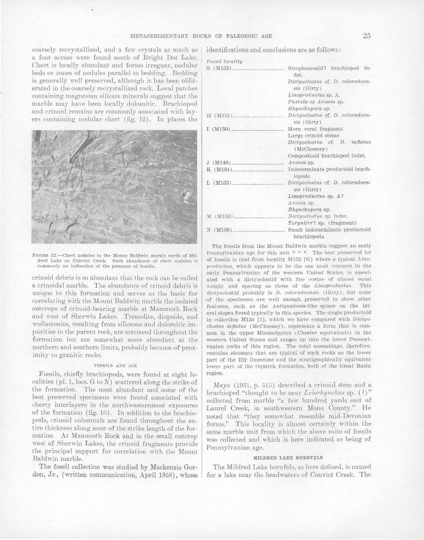
METASEDIMENTARY ROCKS OF PALEOZOIC AGE 25
coa'rsely recrystallized, and a fe,Y crystals as much as a foot across were found south of Bright Dot Lake. Chert is locally abundant and forms irreguar, nodular beds or zones of nodules parallel to bedding. Bedding is generally well preserved, although it ·has been obliterated in the coarsely recrystallized rock. Local patches containing magnesian silicate minerals suggest that the marble may have been locally dolomitic. Brachiopod and crinoid remains are commonly associated with layers containing nodula1~ chert (fig. 12). In places the
FIGURE 12.-Chert nodules In the Mount Baldwin marble north of Mil· dred Lake on Convict Creek. Such abundance of chert nodules Is commonly an Indication of the presence of fossils.
crinoid debris is so abundant that the rock can be called a crinoidal marble. The abundance of crinoid debris is unique to this formation and serves as the basis for correlating with the Mount Baldwin marble the isolated outcrops of crinoid-bearing marble at Mammoth Rock and west of Sherwin Lakes. Tremolite, diopside, and wollastonite, resulting from siliceous and dolomitic impurities in the parent rock, are scattered throughout the formation but are somewhat more abundant at the northern and southern limits, probably because of proximity to granitic rocks.
FOSSILS AND AGE
Fossils, chiefly brachiopods, were found at eight localities (pl. 1, locs. G toN) scattered along the strike of the formation. The most abundant and some of the best preserved specimens were found associated with cherty interlayers in the northwesternmost exposures of the formation (fig. 10). In addition to the brachiopods, crinoid columnals are found throughout the entire thiclmess along most of the strike length of the formation. At Mammoth Rock and in the small outcrop west of Sherwin Lakes, the crinoid fragments provide the principal support for correlation with the Mount Bald win marble.
The fossil collection was studied by Mackenzie Gordon, Jr., (written communication, April 1958), whose
identifications and conclusions are as follows:
Fossil locality G (M152) ------------------- Strophomenid? brachiopod in
det. D'ictyoclostus cf. D. coloradoen-
sis (Girty) Linoproductus sp. A. Pustula or Avon·ia sp. Rhynchopora sp.
H (M151) ------------------· Dictyoclostus cf. D. coloradoensis (Girty)
I (M150) ------------------- Horn coral fragment Large crinoid stems Dictyoclostus cf. D. inflatus
(McChesney) Compositoid brachiopod indet.
J (M149) ------------------- Avonia sp. K (M154) ------------------· Indeterminate productoid brach
iopods L (M155) ------------------- D·ictyoclostlls cf. D. coloradoen-
sis (Girty) Linopro!Luctus sp. A? Avonia sp. Rhynchopora sp.
M (M153) ------------------· Dictyoclostus sp. i11det. Torynifer? sp. (fragment)
N (M156) ------------------- Small indeterminate productoid brachiopods
The fossils from the Mount Baldwin marble suggest an early Pennsylvanian age for this unit * * *. The best preserved lot of fossils is that from locality M152 [G] where a typical Linop!·oductus, which appears to be the one most common in the early Pennsylvanian of the western United ·States, is associated with a dictyoclostid with fine costae of almost equal weight and spacing as those of the Linoproductus. This dictyoclostid probably is D. colomdoensis (Girty), but none
-of the specimens are well enough preserved to show other features, such as the Antiquatonia-like spines on the lateral slopes found typically in this species. The single productoid in collection M150 [I], which we have compared with Dictyoclostus inflatus (McChesney), represents a form that is common in the upper Mississippian (Chester equivalents) in the western United States and ranges up into the lower Pennsylvanian rocks of this region. '!'he total assemblage, therefore, contains elements that are typical of such rocks as the lower part of the Ely limestone and the stratigraphically equivalent lower part of the Oquirrh formation, both of the Great Basin region.
Mayo (1931, p. 515) described a crinoid stem and a brachioped "thought to be near Leiorhynchus sp. (?)" collected from marble "a few hundred yards east of Laurel Creek, in southwestern Mono County." He noted that "they somewhat resemble mid-Devonian forms." This locality is almost certainly within the same marble unit from which the above suite of fossils was collected and which is here indicated as being of Pennsylvanian age.
MILDRED LAKE HORNFELS
The Mildred Lake hornfels, as here defined, is named for a lake near the headwaters of Convict Creek. The

26 GEOLOGY AND MINERAL DEPOSITS, MOUNT MORRISON QUADRANGLE, CALIF. ·
type locality is along the west wall of the canyon of Convict Creek about half a mile north of Mildred Lake. This locality is acoessible by means of a steep trail (not shown on the topographic map of the quadrangle) that branches west off the Convict Creek trail and intersects the Laurel Creek-Lake Dorothy trail at .Lake. Genevieve. From the type locality the formation extends north~estward 21h miles in discontinuous exposure to the canyon of Laurel Creek and sou'theast~ard about 5 miles in continuous exposure to Big McGee Lake, about a mile south of the quadrangle boundary in the Mount Abbot quadrangle. The formation crops out in two isolated exposures south of the Scheelore mine where, as a result of folding, it lies east of the ·Mount Baldwin marble.
The formation ranges in thickness from 500 feet, west of Laurel Mountain, to 1,000 feet; north of Lake Genevieve. Near its southern end the formation may be even thicker, but internal folding in that area prevents measuring the thickness accurately. The contact with the underlying Mount Baldwin marble is conformable and commonly gradational over a few feet. At one place east of Laurel Creek the gradational zone consists of 50 feet of interbedded marble and siliceous hornfels in beds 1 to 5 feet thick.
The rocks consist chiefly of light-gray to dark-gray fine-grained massive siliceous hornfels that weathers reddish brown. White to greenish-gray siliceous calchornfels layers, a few feet to a few tens of feet thick, are locally abundant, especially near Mildred Lake. Bedding generally is not conspicuous in the formation, but, in places, sequences of thin to very thin beds were seen. Relict clastic texture, visible only in thin section, is characteristic. Angular to subround quartz grains 0.05 to 0.1 mm in diameter are scattered through a much finer-grained matrix of granoblastic quartz, feldspar, and mica. Near the south end of the pendant the hornfels is noticeably coarser grained and is commonly phyllitic or schistose. This is interpreted to be a result of recrystallization that is due to the proximity of the
. granodiorite rather than a reflection of coarser grained parent rocks. The formation is of Pennsylvanian and (or) Permian ( ~) 'age.
LAKE DOROTHY HORNFELS
The type locality of the Lake Dorothy hornfels is immediately east of the lake for which the formation is here named; excellent exposures are accessible along the trail from Mildred Lake to Lake Dorothy. The formation is discontinuously exposed from the north end of the ridge separating Laurel and Sherwin Creeks southeastward about 81h miles to Big McGee Lake, about a mile south of the quadrangle boundary in the Mount Abbot quadrangle.
The formation is about 1,000 feet thick north of Lake Genevieve, where it appears least disturbed structurally ; near Lake Dorothy internal folding has resulted in greater apparent thickness. South of Constance Lake a diorite intrusion cuts across the formation, and the adjacent beds are crumpled and faulted. The contact with the underlying Mildred Lake hornfels is commonly gradational over several tens of feet.
The rocks consist chiefly of thin-bedded microgranular plagioclase-pyroxene- (locally ~mphibole-) quartz hornfels. Alternate grayish-black and yellowish-gray layers, several inches thick, give the rock a pronounced striped appearance (fig. 5). The contrasting color of· the layers generally depends on the abundance of finely divided carbonaceous ( ~) material, for ~he layers may or may not be otherwise similar in composition. Generally, however, pyroxene is associated with the lightcolored layers and amphibole with layers that are . darker colored. The abundance of dark-colored rocks, which is greatest in the northern part of the formation, shows a progressive decrease to the south; south of Lake Dorothy the dark layers are increasingly sparse and as a result layering is much less pronounced. Assuming that .the lighter colored rocks most commonly indicate the presence of pyroxene rather than amphibole, the color change suggests that the formation becomes progressively more calcic toward the south. This trend is supported by field testing with HOI which indicates that the rocks in the southern part contain more calcite than those in the north.
The formation is generally homogeneous, and lithologic variations are uncommon. Along the west side of Laurel Creek, the top of the formation is marked by a quartz-wollastonite-pyroxene· hornfels l!ayer about 100 feet thick, but the layer can be traced for no more than a mile to the south. Near the south bouridary of the quadrangle. a few thin layers of quartzite crop out but they extend for only short distances laterally. The parent rock was probably siltstone consisting of varied proportions of siliceous, calcareous, and dolomitic material.
A few fossils were collected from the upper part of the formation on the south side of Bloody Mountain (pl. 1, loc. P), and according to Mackenzie Gordon, Jr., consist of crinoid columnals, a possible sponge, and an indeterminate compositoid brachiopod. The formation is of Pennsylvanian and (or) Permian (?) age.
BLOODY MOUNTAIN FORMATION
The type locality of the Bloody Mountain formation of Permian ( ~) age, here named, is on the northeast slope of Bloody Mountain where excellent exposures are ac.cessible along the jeep trail leading to~ prospect high on the north slope of the mountain. The forma-

METASEDIMENTARY ROCKS OF PALEOZOIC AGE' 27
tion crops out ~in a nearly continuous layer from the north end of the ridge separating Laurel and Sherwin Creeks, southeastward 81h miles to the east slope of Red and White Mountain, llh miles south of the quadrangle boundary in the Mount Abbot quadrangle.
Near the type locality the formation is about 3,000 feet thick, but intrusive granod·iorite has cut out the upper part of the formation and the section is incomplete. The upper contact is preserved at one place near the south boundary of the quadrangle where metavolcanic rocks overlie the formation. There, however, the contact is somewhat irreg\llar and the rocks have been sheared, although the beds on both sides are generally parallel ·with the contact. Near the contact a fragment · of siliceous hornfels was found enclosed in metavolcanic rock thus establishing the metavolcanic rocks as younger. In the north~rn part of the pendant the contact with the underlying Lake Dorothy hornfels is sharp to gradational over a few feet, but in the south: ern part it is less distinct and is typically .gradational over several tens of feet.
The formation consists chiefly of medium- to darkgray massive siliceous c.alc-hornfels and siliceous hornfels, the latter more abundant north of Bloody Mountain and the former predominating to the south. The rocks weather to a dark reddish brown, presumably the .result of oxidation of fine-grained pyrite that is dissem.inated throughout much of the formation. Gray siliceous calc-hornfels layers a fraction of an inch to several inches thick occur throughout the section but are most common south of Bloody ·Mountain. 'rhese layers commonly replace darker hornfels in a.n irregular manner, giving the rock a splotchy appearance. Layers of light-bluish-gray to medium-gray marble, a few feet thick, are common on Bloody Mountain and near the southern end of the pendant but are sparsely distributed through the formation elsewhere. Talus east of the Ilard Point prospect indicates that there is a coarse clastic unit on the steep slope above. Outcrops of similnr rock were not found elsewhere, and the relatively small proportion of this rock in the talus suggests that the layer from 'which it came is probably thin and only local. The rock consists of rounded to angular fragments, as large as an inch in diameter, in a. matrix of dark-gray siliceous hornfels. Many of the fragments are criuoid and brachiopod remains, but some are dark-gray siliceous hornfels, metachert, and dense grn,yish-black impure marble. One discontinuous bed of calcareous sandstone and intraformational conglomerate, about 3 feet thick, c.rops out at the type locality. This bed is of particular interest because· fragments in the congl.omerate clearly indicate that the beds are right side up with tops facing to the west.
689-993 0-64-3
This is one of the few places in the entire stratigraphic section where tops of beds could be positively determined.
In the southern part of the formation. the rocks are commonly lighter colored, and layers of siliceous calchornfels and marble ranging in thickness from less than an inch to several tens of feet are more abundant than to the north. A lens of conglomerate, unusual in the Mount Morrison pendant, crops out on the west slope of Red Slate Mountain east of a small unnamed lake and contains abundant rounded pebbles and cobbles of quartzite.
FOSSILS AND AGE
Fossils have been found at five localities in the formation (pl. 1, localities, Q, R, S, T, and U). All the fossil localities are north of Bloody Mountain and with the exception of locality S, all are in the lower part of the formation; locality S is nearer the top and is in talus. The collections were examined by Mackenzie Gordon, Jr., (written communication, 1958), whose identifications and conclusions are given as follows: Fossil locality •
Q (M160) -------· Neospirifer sp. R (M157) -------· Hor~ coral
Compositoid brachiopod indet. S (M158) -------- Ramose bryozoans
Chonetes aff. C. subZiratus · Girty Small productoid brachiopod (thick muscle
platform in ventral valve) Spiriferella? sp.
T ---------------· Brachiopods? indet. U ---------~-----· Brachiopods? indet.
Fossils from localities T and U are very poorly preserved and were not examined by Gordon.
The fauna of the Bloody Mountain formation is sparser than that of the Mount Baldwin mn_rble. The only collection that contains enough fossils to be termed ·an assemblage is that of the conglomeratic hornfels at locality M158 [S] with bryozoans and brachiopods. The chonetid in this assemblage is of a type with deep, moderately wide sinus, which occurs commonly in Permian rocks of the western United States, and its occurrence together with small productoids with a heavy platform inside the ventral valve !Uggests a possible Permian age for the beds. The single fragment of a Neospirifer found at locality M160 [Q] has rather weak fasciculation and prominent subangular margins bordering on the sinus in the ventral valve. This is· much likeN. bakeri (King) of the middle-Permian of west Texas. In summary, although no well-preserved fossils are present in the Bloody Mountain formation, its fauna suggests possible Permian age. The genera involved, however, are rather long-ranging ones found also.in Pennsylvanian and Mississippian rocks.
SANDSTONE AT BIG SPRING C,A.MPGROUND
A small unfossiliferous outlier of calcareous quartz sandstone is e~posed more than 9 miles from the Mount Morrison pendant near Big Spring Campground at the north edge of the quadrangle. Correlation of this sandstone with a specific formation is not possible, but lith-
28 GEOLOGY AND MiNERAL DEPOSITS, MOUNT MORRISON QUADRANGLE, CALIF.
ologically the rock is similar to the calcareous quartz sandstone units which are common in both the McGee Mountain and Convict Lake blocks of the pendant.
RELATION BETWEEN BLOCKS
Where-as the Bloody Mountain block is clearly the youngest and the relation between it and the underlying Convict Lake block is simple, the relation· between the Convict Lake and the structurally complex McGee Mou:n.tain block is ambiguous. Both of. the latter blocks contain lithologically similar rocks of overlapping age, and both forni grossly homoclinal sequenc.es which are progressively younger to the west. Inasmuch as fossils of Middle Ordovicia.n (Caradoc) age occur in rocks of both blocks, but fossils of Early Ordovician (Arenig) age occuF only in the McGee Mountain block, the rocks of the McGee Mountain block are interpreted as in part contemporaneous with, and in part older than the rocks of the Convict Lake block.
The B.loody Mountain block is. composed of rocks of Pennsylvanian and Perr11ian( ~) age, about 7,250 :feet in stratigraphic thickness, which are progressively
. younger westward and are in fault contact with the rocks of the Convict Lake block. The fault is virtually parallel to the Bright Dot formation, but a minimum stratigraphic thickness of 8,900 feet of strata from the Convict Lake block is missing at the point of greatest stratigraphic separation, northeast of Mount Baldwin. Although there has clearly been movement along the surface of discordance separating the two blocks, the possibility exists that the fault may coincide with an uncon'.formity. This suggested possibility is based on unconformable relations below Permian rocks in neighboring a~eas; No direct evidence in support of an unconformity was found in the Mount Morrison pendant, and, unfortunately, the surface of discordance is- inaccessible over mo~t of its exposed length.
In the Candelaria· Hills, about' 50 miles northeast of the pendant, Permian rocks ove~·lie (lrdovician .rocks with a marked angular discordance (Ferguson and Muller, 1949). Also in the Inyo Mountains 50 miles to the southeast, Carboniferous rocks are reported to directly overlie Ordovician rocks in the Mazourka Canyon area, although little ,is known about the structural relations (I{nopf, 1918). Thegeologic relations 'in these areas show that orogenic. deformation took phice within 50 miles of the Mount Morrison area between the time of 'deposition of the Ordovician. strata of the Convict Lake block and the Carboniferous strata of the Bloody Mountain block.
RELATED ROCKS OF PRE-PENNSYLVANIAN PALEOZOIC AGE IN THE GREAT BASIN
Two distinct facies of strata of pre-Peml.sylvanian Paleozoic age occur in Nevada and eastern California,
a clastic (western) and a carbonate (eastern) facies (Roberts, Hotz, Gilluly, and Ferguson, 1958). On the basis of lithologic character and fauna, the pre-Pennsylvanian strata of the Mount Morrison pendant belong to the clastic (western) facies. The distribution of the known clastic' facies is shown on figure 13, and hlcludesrocks' that range in age from Cambrian to ~1ississippian, although most are Ordovician.
The nearest rocks of the clastic :facies tha.t have been described are at Silver Peak, Nev.~ about 40 miles east of the Mount Morrison quadrang-le .. There the Ordovician strata were briefly described by Turner (1902 and 1909), who named them the Palmetto ~ormation. The formation consists of dark-colored thin-bedded chert, layers of graptolitic slate, and lesser amounts of limestone and sandstone. Graptolites of both Beekmantown and N ormanskill ages are present, but the formation ·description is not adequate to. permit detaile~ correlation .. The name "Palmetto" has been used by Ferguson and others (1953, 1954) to denot.e rocks of similar o-enera.I lithologie character and· age In the area north a;d east of Silver Pea.k. The following formation names have been used. elsewhere in Nevada for clastic: facies ·ordovician: Toquima (Ferguson, 1924), Vinini (Merriam and Anderson, 1942), and Valmy (Roberts, 1951). Concerning faunal correlation, R. J. Ross, Jr. (written communication, 1958), who studied the graptolites from the ·Mount Morrison pendant, states: This graptolite fauna is correlative with those reported from the Vinini, Valmy, and Palmetto formations of Nevada, from the Phi Kappa formation and Ramshorn slate of Idaho, and from the Ledbetter slate of Washington .
. Rocks similar to those of Ordovician age in the Mount Morrison pendant crop out in the Sierra Nevada near June Lake, 30 miles north of the Mount Morrison pendant and near Bishop, 25 miles south. In his paper on the, Quaternary geology of the June Lake dist~ct, Putnam ( 1949) briefly described the metamorphic rocks. One is a calcareous sandstone which strongly resembles the distinctive calcareous quartz sandstone strata in the M~Gee Mountain and Convict Lake blocks of the Mou~t Morrison pendant.
In summary it can be stated that although the Ordovician and ·Silurian(~) rocks of the Mount Morrison pendant resemble the clastic-facies rocks of Ordovician. age of_ Nevada, detailed correlation has not . been ~ttempted. Correlation is not yet warranted because distances to well described sections are too grea.t and nearby sections are inadequately described .. ~n comparing_ the gross lithologic features, however, 1~ ~eei?s reasonably certain that rocks of the western fames In California and Nevada were deposited under similar erivironmei1tal conditions, possibly in parts of the same basin of· deposition.
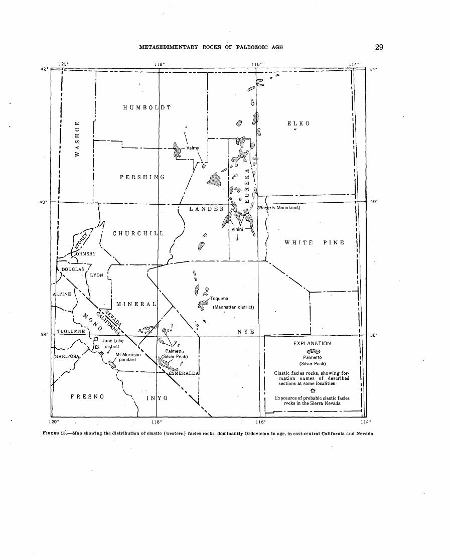
METASEDIMENTARY ROCKS OF PALEOZOIC AGID
120" 118" 42" ~-,----------------------------~----------------------------~--------------------------~~~==~ ,----,----- -----,----- ---(JP --------
! i ' ! i i HUMBOLDT !
r 1
~\ ~~ - 8t_~'V'my\J .. ·· '·~~ ~?Dri: .. ','''
I
r- -----: .____-
I I
I , p tD \a tP9 <'<.
PERSHING / ~ i ~~ I •. ,. D til
I
I
CHURCHILL
ELKO
' I I ' I
----~
PINE
EXPLANATION
~ Palmetto
(Silver Peak)
Clastic facies rocks, ~howing formation names of described sections at some localities
* Exposures of probable clastic facies rocks in the Sierra Nevada
- ---- - ----- - ---1
29
40'
38'
l<'JOURill 13·.-Mnp showing the dlstrfbutton·of clastic (western) facies rocks, dominantly Ordovician In age, in east-central Callfornta and Nevada.

30 GEOLOGY AND MINERAL DEPOSITS, MOUNT MORRISON QUADRANGLE, CALIF.
REGIONAL COMPARISON OF ROCKS OF PENNSYLVANIAN AND PERMIAN(?) AGE
The nearest rocks that are probably correlative with part of the Pennsylvanian and Permian(~) .section of the Mount Morrison roof pendant are exposed in the Mount Tom quadrangle, about 9 miles to the southeast. There, a small roof pendant in Pine Creek lies along the projected strike of rocks in the Mount Morrison pendant and contains two stratigraphic units which resemble the .Mount Baldwin marble and the Mildred Lake siliceous hornfels ( P. C. Bateman, oral communication) . Because these rocks are more extensively deformed and contain no fossils, correlation with formations in the Mount Morrison pendant must be regarded as tentative. Fifty miles to the west in the western foothills of the Sierra Nevada, the Calaveras formation includes rocks which are lithologically similar to and are probable age equivalents of the Pennsylvanian and Permian ( ~) section in the Mount Morrison pendant. One major distinction .between the two sections, however, is that the Calaveras contains abundant greenstone, whereas the Pennsy I vanian and Permian ( ~) rocks of the Mount Morrison pendant contain none. The nearest well-described unmetamorphosed section is 75 miles southeast of the quadrangle in the Ubehebe Peak quadrangle (McAllister, 1955, p. '12-13). The rocks there are chiefly limestone with smaller amounts of shale and siltstone; thus they differ distinctly froni rocks of the Bloody Mountain block, which are largely siltstone with smaller amounts of limestone. Pennsylvanian and Permian sections have been described from north -central and eastern Nevada, but there, too, t,he rocks are typically more calcareous than those in the Mount Morrison pendant. Rocks of similar age have been described from Taylorsville and Redding, Calif., but these localities, as well as those in Nevada, are 100 miles or more from the Mount Morrison pendant.
RELATION TO THE OVERLYING METAVOLCANIC ROCXS
Only two small segments of the metasedimentarymeta volcanic contact are preserved-one at Mammoth Rock, a mile south of Old Mammoth, and the other on Red Slate Mountain near the south boundary of the quadrangle; elsewhere the contact has been obliterated by intrusive granitic rocks. On Red Slate Mountain metatuff overlies the Bloody Mountain fo:r;mation along a vertical contact. The contact relations are not clear for although primary structures in both units are virtually parallel to the contact, there is also some shearing along it. A fragment of siliceous hornfels was found enclosed in the tuff, however, establishing the metavolcanic rocks as definitely younger than the Bloody Mountain formation. At Mammoth Hock, meta volcanic
breccia, stratigraphically the lowest unit in the metavolcanic seque.nce, and the Mount Baldwin marble are in contact along a vertical fault. Fragments of metasedimentary rocks, somewhat rounded, are scattered widely throughout the meta volcanic breccia and establish it as the younger of the two units. Bedding is essentially parallel in both the marble and bedded tuff within the metavolcanic breccia, although bedding in the marble adjacent to the fault has been obscured by a zone of alteration a few tens of feet wide. Three formations, the Mildred Lake, Lake Dorothy, and Bloody Mountain, totalling 4,750 feet in thickness, are cut out along the fault, and an unknown thickness of the metavolcanic breccia is also missing. The presence of somewhat rounded fragments of me-tasedimentary rocks in the metavolcanic breccia suggests that a period of erosion preceded the deposition of the pyroclastic rocks. The contact appears to be conformable, however, near Red Slate Mountain and 4 miles northwest of Mammoth Rock in the Devils Postpile quadrangle, where it is exposed for about 4 miles.
METAVOLCANIC ROCKS OF JURASSIC AND TRIASSIC(?) AGE
An elongate northwestward-trending septum of metavolcanic rocks occupies about 15 square miles in the southwestern part of the quadrangle and extends southward into the Mount Abbot quadrangle where it occupies an additional 2 square miles. Another small mass of probable metavolcanic rocks is enclosed in porphyritic quartz monzonite near Scoop Lake in the southwestern corner of the ql;ladrangle. The long axis of the septum is parallel with both the foliation and bedding in the metamorphic rocks. Dips are steeply west and tops of beds uniformly west. The rocks consiE!t of metamorphosed tuffs, flows, and hypabyssal intrJISives, which range in composition from andesite to rhyolite. Interca.Iated in the meta volcanic sequence are a few waterworked tuffaceous layers and spatse layers that were originally shale, marl, and (or) limestone. Six mappable units have been distinguished, most of which can be further subdivided locally into less distinctive and less extensive units. For brevity in the ensuing discussion the cumbersome prefix "meta" will be omitted from the volcanic rock names.
The rocks are thermally metamorphosed and, like the metasedimentary rocks, show a maximum grade equivalent to the hornblende hornfels facies of Turner ( Fyfe, Turner, and Verhoogen, I9.58, p. 205-211). In general, the primary textures of the rocks are fairly well preserved, but, locally, dynamic forces were sufficient to form hornblende-biotite-plagioclase. schist. Schistose rocks are most common along the west side of the septum near the contact with porphyritic quartz monzo-

METAVOLCANIC ROCKS OF JURASSIC AND TRIASSIC (?) AGE 31
nite, where recrystallization and shearing has obliterated much of the original volcanic texture. The contact with granodiorite along the east side of the septum, on the other hand, is generally sharp; with little obvious deformation in either rock at the contact. Some material was added or 1-edistributed in areas undergoing the greatest dynamic change, a fact shown by "eyes" and veins of epidote and subordinate quartz and garnet a fraction of an inch to a few inches thick. Silicified zones, particularly evident in the northeastern part of the septum and east of both Duck and Lee Lakes, give further evidence of the movement of material during metamorphism. Near the northeast end of the septum, pyrite, a little garnet, and some gold and silver are disseminated in the silicified zone. A notable feature is the dense texture of the silicified rock, which in most places obscures the primary texture. Outcrops of the si1 icified rock are distinguished from the surrounding rocks by their reddish color, a result of oxidation of the pyrite. It is in this altered zone that the mines of the Mammoth District are located.
VOLCANIC BRECCIA OF MAMMOTH ROCK
Rhyolitic volcanic breccia, containing abundant angular volcanic fragments as much as a foot across and smaller subrounded to rounded metasedimentary fragments, is exposed south of Mammoth Rock on a prominent ridge east· of Lake Mary. The breccia has an outcrop area of less than half a square mile but nevertheless includes nbout 1,200 feet of strnta. The unit is stratigraphically the lowest in the volcanic series and is in fault contact with the Mount Baldwin marble at Mammoth Rock. In general the rock is massive, but locally westward-dipping tuffaceous sediments are interbedded with it.
The rock is commonly medium light gray to medium dark gray on fresh surfaces and light brown to moderate red brown on weathered surfaces; the abundance of angular to subangular fragments gives it a distinctive ttppearance in the field. Most of the fragments are dark-colored volcanic rock somewhat more mafic than the matrix; less common are rounded to subangular fragments of metasedimentary rocks, typically darkgray siliceous hornfels, light-gray quartzite, and medium-gray marble, as much as one inch in maximum dimension. The matrix .is· chiefly microgranular quartz, sodic to intermediate plagioclase, and potassium feldspar with an average grain size of about 2 mm; locally 1- to 2-mm subhedral to anhedral quartz grains are present. Less abundant are pale-green to colorless amphibole, muscovite, biotite, chlorite, clinozoisite, calcite,, sphene, apatite, and pyrite. Collectively these minerals constitute no more than 10 percent of the rocl;r.
There is little evidence of metasomatic addition of
material to the rock, but some reconstitution of preexisting minerals is indicated by scattered granoblastic aggregates of' potassium feldspar and albite, which locally have shapes that suggest former sanidine crystals. Rims of albite around a few of these aggregates outline the shapes of the presumed former crystals. Aggregates of secondary calcite, clinozoisite, chlorite, and amphibole, somewhat coarser grained than the groundmass, provide further evidence of reconstitution. None of these aggregates obviously reflect the shape of former crystals, but the almost invariable close association of two or more of the four minerals suggests that they probably formed from an original ferromagnesian mineral.
The unit is a breccia of obvious volcanic origin, and locally intercalated thin-bedded tuff and tuff breccia indicate that it was in part deposited in water .. Inasmuch as most of the volcanic fragments . are not rounded, subaqueous transport probably played only a minor part in the deposition of the breccia. Because most of the sedimentary Jragments are somewhat rounded and are heterogeneously scattered through the rock, the breccia was probably extruded through sedimentary rock debris.
LATITE OF ARROWHEAD LAKE
Most of the latite of Arrowhead Lake consists of intrusive hypabyssallatite, but it also includes a little tuff and possibly some flows. The unit crops out as a northwest-trending belt that extends southeastward from Lake Mary for 6 miles to its termination against granodiorite, a mile southeast of Duck Lake; the total outcrop area is 2Y2 square miles. Intrusive latite exposed near Lee Lake is probably correlative with the latite of Arrowhead Lake. The maximum exposed thickness, .northeast of Arrowhead Lake, is about 5,000 feet.
. The typical unaltered intrusive rock ranges in color from medium light gray to medium dark gray, the darker shade generally predominating. It is extremely dense, generally porphyritic, and contains abundant equant dark- to light-gray feldspar crystals, 2 to 5 mn1 in diameter. Weak foliation generally strikes parallel to the regional trend of the unit and dips steeply. Layering is rare, and flow banding was recognized in only a few places. The rock intrudes the quartz latite tuff of Skelton Lake at several localities; and south of Laurel Lakes, dikes lithologically similar to the latite of Arrowhead Lake, but too small to show on plate 1, cut the Bloody Mountain formation.
Most of the tuffaceous rocks included with the latite of Arrowhead Lake crop out east of Arrowhead Lake and northeast of Duck Lake and are intimately mixed with the hypabyssal rock. They are included in the latite of Arrowhead Lake because it was impossible to
32 . GEOLOGY AND MINERAL DEPOSITS, MOUNT MORRISON QUADRANGLE, CALIF.
·.map them separately in the field. The tuffaceous rocks are· ~ell foliated, generally lighter colored than th~ intrusive latite, and commonly present a sandy. or fragmental appearance. Quartz fragments are visible in sonie places and ·in others autolithic fragments that measure half an· inch across can be seen. In many places, the tuffaceous rocks grade almost imperceptibly into the massive porphyritic rocks.
Lenses of metasedimentary rocks consisting of muscovite schist, marble, quartzite, and andalusite hornfels are exposed at a few places i·ri the latite. Muscovite schist, exposed at the northernmost end of the unit, contains quartz grains ·of possible clastic origin. Marble lenses are exposed north and east of ArrowheadLake; the largest lens is 20 feet thick and extends more than 100 feet along strike. Some of the marble units are probably veins rather than sedimentary deposits, for in the Mammoth Consolidated mine, a vein of massive calcite, 10 feet thick, extends discontinuously more than 300 feet along the. haulage level. Outcrops. of siliceous rocks east of Duck Lake show moderately well preserved clastic texture, locally, and some closely resemble the dark-colored vitreous quartzite in the metasedimentary rocks of Paleozoic age. Clastic texture is ab8ent in much of the rock, however, and, in places, massive siliceous rock can be traced locally into porphyritic latite, suggesting that the siliceous rock may, in part, represent silicified latite. A layer of andalusite hornfels interstratified in the siliceous rock contains stubby fleshcolored prisms of andalusite that give the rock a superficial resemblance to the porphyritic latite.
Zones of vesicles parallel with the regional strike were found in the latite at a few places and are associated locally with lenses of breccia. The vesicles are generally flattened along a plane parallel to the regional foliation and range in size from a fraction of an inch to 2 inches in maximum dimension. Because structures diagnostic of flows were not found, it is not known whether the vesicular rock is a flow or a sill.
The tuffaceous rocks range in composition from· quartz latite to rhyolite, and consist of both crystallithic and crystal tuffs. ·The crystal-lithic tuffs are composed of corroded and somewhat resorbed crystals of andesine and less abundant potassium feldspar and of subangular fragments of latite in a microcrystalline matrix composed of oligoclase( ~), quartz, biotite, muscovite, and opaque minerals. The feldspar crystals average about 2 mm in diameter, the lithic fragments about 12 mm in maximum dimension, and the grain size of the matrix averages 0.01 to 0.02 mm. Local abundance of rounded lithic fragments suggests that the rock may be epiclastic in part.
The crystal tuffs are rhyo]jtic and are much less abundant than crystal-lithic tuffs. They are composed chiefly of partly resorbed ~ngular quartz crystals set in a dense weakly birefringent .matrix, most of which is unresolvable under the microscope and is probably devitrified glass. The most striking microscopic textural features of the rhyolite are wispy aggregates of fine-grained mica which •are commonly bent around the quartz crystals in mnch the same manner as deformed pumice fragments in a welded tuff.
PETROGRAPHY
The typical intrusive rock, which makes up t~e bulk of the unit; is composed of 20 to 30·percent subhedral to euhedral plagioclase phenocrysts, 2 to 5 mm in maximum dimension, in a fine-grained granoblastic matrix (average grain size, 0.02 mm) of plagioclase (albite to andesine), olive-green biotite, and bluish-green amphibole. The phenocrysts range in composition from albite. to labradorite; the average composition of crystals · ex,amined .is that of sodic andesine. Progressive zoning and polysynthetic twinning are commonly preserved, though in many specimens alteration products obscure them. Dark minerals constitute 15 to 30 percent of the rock and are disposed in subrectangular aggregates, 2 to 3 mm ~ross, suggesting the outlines of original ferromagnesian phenocrysts. Biotite generally accounts for 60 to 90 percent of the dark mineral content. ·The plagioclase in the groundmass is dominantly intermediate andesine and, in a few specimens, retains its original form as laths. In some specimens, however, the matrix consists of a weakly birefringent mass of material that is unresolV1able under the microscope, and it probably represents devitrified glass. The common accessory minerals are apatite, sphene, opaque minerals, tourmaline, and garnet. In a few specimens, quartz occurs in minor amounts as crystal fragments or as mosaics comparable in size to the feldspar phenocrysts; quartz may also compose an appreciable part of the matrix but was rarely recognized because of the fine grain size.
Two specimens showil).g a minimum amount of alteration were chosen for chemical analysis, one (M-687) from east of Lake Mary and the other (M-867) from east of Duck Lake. (table 4). The rocks are megascopically indistingnishable from one another. Specimen M-687 is a dark quartz latite according to the chemical classification of Rittman ( 1952), but it is considerably less silicic than average quartz latite ( dellenite). With the exception of quartz, the norm compares favorably with that of average latite as given by Nockolds (1954). Microscopic examination shows that about 25 percent of the rock consists of phenocrysts of· calcic andesine ( An4s-so) in an extremely fine-grained granoblastic rna-

METAVOLCANIC ROCKS OF JURASSIC AND TRIASSIC (?) AGE 33
trix..of green biotite and plagioclase, minor amounts of green amphibole, and a little calcite. Quartz was not · recognized, but judging :from the norm it is doubtless present in the matrix. Sparse grains of potassium :feldspar and epidote were recognized. Many of. the andesine crystals are cloudy and contain much green biotite which is arranged in concentric zones in some crystals. Some show patchy alteration to potassium :feldspar and albite. Polysynthetic twinning is well preserved and in many crystals progressive zoning is distinct; some crystn]s are thinly mantled by plagioclase slightly more cnJcic than the interior o:f the crystal.
'!'ABLE 4.-0hmnioal a,na11}ses and ?W1'nt8 of metavolcanic 1·ooks
[AMiysos by tho rapid method (Shapiro and Brannock, 1956). Analysts: K. E. White, P. L. D. Elmore, P. W. Scott]
Rock type and field and laboratory (In parentheses) nos.
--Quartz Dark Dark Dark latlto quartz alkali alkali
latlte trachyte trag)!;tle
M-700a M-687 M-867 M-702-B 144084 (144081) (144082) (144085)
Chemical analyses, In weight percent
SlOt-------··-----------------·-- 73.4 60.9 63.2 58.4 Ah03----··----·---------------- 14.6 16.6 16.7 17.0 FotOs------------------------·-- .6 2.3 2.9 7.1 Foo_____________________________ 1.1 3.1 2. s 1. s MgO------·--------------------- . 7 2. 4 2. 2 2. 5 CaO.- -----------------------·-- 2. 9 4. o · 2. o 2. 4 NatO----------------------~---- 1.9 3.1 5.7 7.6 KtO----------------------------- 3. 4 4. 6 3. 6 1. 3 '1'101---------------------------- . 24 . 64 . 6 . 82 PtOa---------------------------- .1 . 24 . 23 . 32 MnO-----·--------------------- .12 .16 .1 .1 JhQ_____________________________ . 62 . 76 . 62 . 72
COt----------------------------- <. 05 . 64 <. 05 <. 05 1-------l-------l-------l-------
rrotaL •••••••••••••••••••• · 100 100 100 100
Norms, In weight percent
qtz •••• __________ ------ __ -----·- _ 40. 9 11. 8 8. 1 2. 1 or __________________ • ___________ _ 20. 0 27. 2 21.1 7. 8 ab ____ -- _- ____________________ • __ 16. 2 26. 2 48. 2 64. 5
an ______ ---- _____ -·----- __ ---· __ 14.5 17.8 9.5 8.3 (An47) (An•o) (An,a) (Ann)
(tiOP----------------------------- ------------ I. 6 . 5 2. 8 hyp_____________________________ 4. 0 9. 1 7. 0 5. 0 ILP------------------·------------ ------------ ------·----- ------------ ------------rutile. ______________ • _________ • ________________________ ~ ~ _________ • ________ • ____ _
cor •• ---------------------------- 2. 5 ------------ ------------ ------------pyr __________________________ , __ ------------ ----------·-~ ------------ ------------mgt_____________________________ . 9 3. 3 4. 2 3. 5 lim______________________________ . 5 1. 2 1. 2 1. 5
hom·---------------------------- ------------ ------------ ------------ 4. 6
'l'otaL ___ -----------------
Specific gravity (powder) _______ _ Specific gravity (lump) ________ _
Spoclmon locallttos:
99.5
2. 70 2. 50
98.2
2. 76 2.67
99.8
2. 74 2.64
M-700n. 1,000 ft west of Skelton Lako. M-687. 2,300 ft cast of Lake Marr. M-867. 1,200 ft west-southwest o tho SW cor. sec. 31, T. 4 S., R. 28 E. M-702-B. 3,500 ft west of Barney Lakt>.
100. 1
2. 76 2.63
Specimen ¥-867 is dark alk~li trachyte according to Rittm'an's chemical classification ( 1952) ; and although megascopically similar to M-687, it diffe~s markedly in N a20 and CaO content (see table 4). Microscopic examination shows that 20 to 25 percent o:f the rock consists o:f albite-oligoclase (the most cal<?ic
about An15 ) phenocrysts set in a felty matrix of chiefly ··albite-oligoclase, with smaller amounts of green biotite and quartz, and traces of chlorite, epidote, clinozoisite, magnetite, and sphene. Many of the phenocrysts are antiperthitic containing potassium-feldspar in small patches irregularly distributed through the crystal. In general the rock appears to be less altered than M-687, but the unusually high N a20 content suggests metasomatism. The amount o:f saussuritic alteration is too Small to account for any significant change in the anorthite content of the plagioclase. None of the replacement :features observed by Gilluly (1935, p. 227-232) in albitized rocks of eastern Oregon were observed in specimen M-867, and any albitization either took place very early or the alteration was so complete that all clues to the process were obliterated. Rarity of replacement textures, such as tlio8e described by Gilluly, favors· the view that the albitization was early, but such negative evidence does not rule out the possibility that it was late.
AL'TIERATION
Alteration is widespread in the unit but is most con~ spicuou~ in a· zone extending frqm Arrowhead Lake northwest to Lake Mary, where a vivid brick-red color distinguishes the zone from the surrounding rocks, even when viewed from a considerable distance. The altered latite is typically fine grained, medium light gray to medium gray, and weathers moderate reddish brown as a result of oxidation of fine-grained pyrite disseminated through the. rock. The.chief e:ff~cts of the alteration are saussuritization of the feldspar, replacement of subhedral :fertomagnes1an minerals by fine-grained aggregates of amphibole, mica, chlorite, and opaque minerals, the addition of pyrite to thoroughly "hornf.elsed" latite, and local intense silicification. Epidote and garnet in·. veinlets and as replacement "eyes" are locally •a:bundant ·in the altered latite and in places are accompanied by quartz and calcite. Probable relicts of ·original plagioclase phenocrysts consist of crudely rectangular quartz-plagioclase mosaics averaging 1about a millimeter in length. They are set in a dense ( a:v:erage grain size 0.04 mm) matrix of quartz, plagioclase, 'and muscovite with lesser amounts of phlogopite. Sparse euhedral garnet porphyroblasts ·were noted locally. The graduation from unaltered latite to· the pyritic hornfels commonly occurs through a distance of only a few feet.
ORIGI~
The flows, tuffs, t~ffaceous sedrments, and calcar.eous sediments ( ~) are remnants of ~a dominantly volcanic pile, containing sedimentary interlayers, that was d~:posited. on the breccia of ·Mammoth Rock. Afte; the deposition of these rocks and the overlying quartz latite
. . .. • '

34 GEOLOGY AND MINERAL DEPOSITS, MOUNT MORRISON QUADRANGLE, CALIF.
----------------- Approx.i.mately 8 miles
South North o'
Volcanic series of Pu.rple Lake
5000'
FIGURE 14.-Diagrammatic section of metavolcanic rocks before folding and intrusion by granitic rocks.
tuft' of Skelton Lake, porphyritic latite intruded both .units but chiefly formed large mainly concordant bodies stratigvaphically below the quartz latite tuft' of Skelton Lake. Several dikes and sills of latite in the quartz latite tuff establish the porphyritic latite as younger (fig. 14).
QUARTZ LATITE TUFF OF SKELTON LAKE
Quartz latite tuft' crops out as a continuous layer for about 5 miles from northwest of Skelton Lake south to its termination agajnst granodiorite east of Purple Lake, and similar and probably correlative rocks are exposed south and east of Lee Lake. The total area of exposure is about 3 square miles. The .maximum exposed thickness is over 4,000 feet, but the total original thickness may be somewhat greater considering that the unit is intruded by the latite of Arrowhead Lake along much of its eastern contact. The rock is a remarkably homogeneous crystal-lithic tuft'. In most exposures it is light to medium gray and in some places, particularly along the prominent ridge near the north end of the outcrop, its color and weathering habit give the rock a marked resemblance to granitic rock. Most specimens have an extremely fine-grained groundmass inset with crystal fragments of. quartz; less abundant feldspar, and scattered dark-colored angular dense rock fragments a fraction of an inch to more than an inch in maximum dimension. No bedding was seen but steep secondary foliation parallel to the regional northwest trend of the mass is evident on most weathered surfaces and may have developed along primary layering. The foliation is commonly shown by elongate pits where muscovite stringers have weathered away and less commonly by small dark elongated quartzose inclusions. The foliation is rather poor and the rock does not normally break preferentially parallel to it.
Microscopically the rock shows remarkable homogeneity. Most noteworthy is the uniform. percentage of
quartz fragments. All thin sections studied contain between 15 and 20 percent (based on point-count analyses) of rounded, angular, and embayed quartz crystals as large as 3 mm ( fig.15).
Nearly all the sections studied contain both plagioclase and potassium feldspar crystals, which together compose about 25 pe·rcent of the rock. Both varieties of feldspar are considerably altered and are commonly clouded with tiny inclusions too small to be identified. This alteration obscures the optical properties of the feldspars, and distinction between the two types is possible only locally. A few relict crystals of microcline and plagioclase (as calcic as Anao-as) were identified on the basis of twinning and relative relief. Both types of feldspar are partly replaced by albite or albiteoligoclase which typically forms irregular indistinct patches within the crystals. The crystal boundaries are considerably sutured and indistinct as a result of encroachment and corrosion by the groundmass. The best method for rapid appraisal of the feldspar crystal content in the rock is the examination of thin sections in reflected light; the crystals appear bluish white against a relatively dark background apparently because of minute inclusions which cloud the crystals. Crystal shapes, generally indistinct, are shown by this method to be dominantly subhedral.
Muscovite composes 10 to 20 percent of the rock and occurs both as disseminated flakes and as elongate aggregates, which are, in part, bent around adjacent quartz and feldspar grains (fig. 15). Biotite is a minor; but persistent, constituent.
The matrix of the rock consists of an extremely finegrained ( 0.005 to 0.02 mm) mosaic of quartz, alkalic feldspar, and some muscovite. Most of the lithic fragments consist of a microgranular mosaic of quartz, but a few are rich in muscovite. One, subangular light-gray quartzite fragment, 2 inches across, and several l-inch

METAVOLCANIC ROCKS OF JURASSIC AND TRIASSIC (?) AGE 35
FIGUR!l 15.-Photomicrographs of tulf. .A, Metaquartz latlte tuff of Skelton Lake showing texture resembling that of welded tuff. Angular quartz grains are In a dense matrix of quartz, potassium feldspar, and mica. Plane·polarized light.· B, Bishop tuff of Gilbert '(1938), showing texture typical of welded tuff. .Crystals of quartz, Q, and .sanldline, S, and fragments of glass, G. are in a matrix of vesicular glass. Plane-polarized light.
rounded marble fragments were also found in the tuff. Subangular to angular fragments of darker volcanic ( ? ) material, several inches across, are common in the tuff southeast of Lee Lake, south of the quadrangle boundary. Because of the fine-grained nature of the major part of the rock, a typical specimen was chemically analyzed in order that the rock could be accurately classified. The specimen, taken from west of Skelton Lake (table 4), No. M-700), defines the rock as quartz latite according to Rittman's (1952) chemical classification.
The tuffaceous nature of the rock is established by the abundance of angular crystal fragments. In general, the rock bears a remarkable resemblance to the Pleisto-
cene Bishop tuff (Gilbert, 1938; Rinehart and Ross, 1957), a rhyolitic ignimbrite which covers a large area east of the quadrangle. The similarities between the two rocks include (1) the shape, percent, and distribution of quartz fragments; ( 2) textural relations, particularly the deformed aggregates of muscovite whose shape and relations are similar to deformed glass shards and pumice fragments found in welded layers of the Bishop tuff (see fig. 15); and (3) the homogeneity in composition of the unit throughout a thick section. These similarities suggest that the qua.rtz latite of Skelton Lake was probably deposited as a nuee ardente. The amount of welding which may have existed in the original rock cannot be determined owing to the complete devitrification during metamorphism. The abundance of angular fragments, several inches across, in the probable correlative tuff east and south of Lee Lake may indicate that these layers are closer to the source than is the tuff farther north.
TUFFACEOUS SEDIMENTARY ROCKS AND MARBLE OF DUCK LAKE
Dominantly sedimentary rocks form a continuous layer about 5% miles long extending from west of Arrowhead Lake to east of Purple Lake and constitute a total outcrop area of about a square mile. The unit ranges in thickness from less than 500 feet, west of Barney Lake, to more than 1,000 feet, south of Duck Lake. Perhaps the most distinctive feature of the unit is the relative abundance of thinly laminated to very thick bedded epiclastic rocks. The epiclastic rocks-consisting chiefly of tuffaceous sandstone and siltstone, lesser amounts of calc-hornfels and marble, and a few thin beds of slate-are interlayered with massive fine- to medium-grained tuff' that is rhyolitic to dacitic in composition. The pyroclastic rocks compose as much as half of the unit north of Duck Lake and considerably more than half south of the lake. The rocks range in color from very light gray to medium dark gray, the darker shades predominating. Planar orientation of the dark minerals, principally mica, and flattening of fragments in the tuffaceous rocks give the unit a moderately well defined foliation. Few of the rocks, however, break parallel to the foliation. Foliation in rocks that are bedded is parallel to bedding.
Marble, the most distinctive lithologic type in thesequence, is limited to a single bed near the base of the unit and extends south from the northernmost exposure of the unit to the north shore of Duck Lake, where it pinches out. It is fine grained; medimn gray on a fresh surface weathering to brownish gray, and ranges in thickness from a few tens of feet to a maximum of 100 feet. It contains some detrital quartz grains and here

36 GEOLOGY AND MINERAL DEPOSITS, MOuNT MORRISON QUADRANGLE, CALIF.
and there contains abundant nodules and lenses of chert. · Zones containing calc-silicate minerals were found at a few places.
In~erlayered through the unit are beds of siliceous calc-hornfels and siliceous hornfels, in various shades of green and gray, which range in thickness from less than an inch to a few feet. Microscopic examination shows that the rocks consist chiefly of a .fine-grained (0.01 to 0.1 mm) mosaic of quartz- and feldspar with admixtures of amphibole, biotite, and less commonly, pyroxene. Although clastic texture is generally not preserved, the laminae show marked differences in composition, grain size, and thickness and are almost surely epiclastic in origin. The ferromagnesian mineral content is generally less in these rocks than in somewhat similar appearing siliceous. calc-hornfels in the Paleozoic metasedimentary section.
The silty and sandy tuffaceous sedimentary rocks are mo~t common north of Duck Lake, where they are chiefly associated with marble and siliceous c~lchornfels. Many layers are finely laminated, and in some, moderately well graded bedding shows that tops of beds are t~ the west. The layers are of various colors, but most are shades of gray, and·local.muscovite-rich layers have a greenish tint. Some thin layers of darkgray slate are also locally associated with both silty to sandy tuffaceous sedimentary rocks and siliceous calchornfels. Microscopic examination shows that the tuffaceous siltstone and sandstone are composed of a relatively small proportion of subangular to subround crystal fragments of quartz and minor amounts of andesine, as much as 1 mm in diameter, in a dense (0.015 :inm) matrix of quartz, potassium feldspar, and albite(~). Irregularly shaped patches composed of biotite, amphibole, plagioclase, and quartz suggest relict rock fragments. Biotite and locally muscovite are abundant as thin discontinuous layers and tiny shreds. ·
Massive crystal tuffs ranging iri composition from . quartz latite to dacite constitute . most of the volcanic rocks interbedded with the epiclastic rocks. These rocks are light gray to dark gray and contain abundant feld~par and less abundant quartz crystals measuring as much as 2 mm across. Some of the rocks resemble the latite of Arrowhead Lake, but most are distinctly lighter colored and contain a significant amount o:f quartz. The essential minerals consist of quartz, oligoclase, potassium feldspar, green biotite, and green amphibole. The feldspar occurs both as large crystals and as major constituents of the matrix. Biotite and amphibole commonly form anhedral shreds and needles, either in discrete layers or scattered throughout the matrix. Most of the rocks have been extensively saussuritized.
In addition to the massive tuffs, a particularly distinctive light-gray extremely dense rhyolite occurs dis. continuously at the top of the mapped unit and is more than 300 feet thick near Purple Lake. Faint banding was detected locally, and in a few places crude foliation is par.allel to the regional trend, but in general the rock is practically structureless. Feldspar phenocrysts, as much as 2 mm in length, are sparsely scattered through the rock; a single hand specimen typically contains no more than a half dozen that are visible with the aid of a hand lens. Microscopic examination shows sparse oligoclase phenocrysts, which are partly fragmental, in a fine-gra]ined mosaic ( 0.015 to 0.08 mm) o:f oligoclase, qnartz, potassium feldspar, and less than 1 percent of pale-green mica, chlorite, and opaque constituents. From the angular appearance of many of the phenocrysts and from the lack of primary structures, the rock is interpreted as a tuff.
VOLCANIC SERIES OF PURPLE LAKE
The volcanic series of Purple Lake is a thick sequence of dominantly pyroclastic rocks that is continuously exposed from half a mile west of the quadrangle boundary southeast·ward to the south end of the pendant in the Mount Abbot quadrangle; the total outcrop area is about 6 square miles. The unit conformably overlies the tuffaceous sedimentary rocks and marble of Duck Lake and is rubout 7,000 feet in maximum exposed thickness; the original thickness was probably greater as intrusive rocks of the batholith delimit the unit on the west. Distinguishable layers within the unit are typically lenticular and can generally be tr~ced laterally for only a few hundred feet. They range in color from light gray to dark gray, the darker shades generally predominating. Most of the rocks, both light and dark, are massive porphyritic types containing abundant very light gray feldspar crystals, 1 to 2 mm in maximum dimension. Interstratified with the porphyritic rocks are layers of thinly lap1inated to very thick bedded very fine grained siliceous hornfels, less abundant layers of calc-hornfels, and a few thin discontinuous layers of medium-to coarse-grained marble. Foliation is poorly developed in most rocks, but in some it is sufficient to allow the rocks to split preferentially along the foliation plane; a few of the latter can be classifie~ as phyllite and schist. Mica is moderately abundant in most rocks and its orientation ~efines most of the foliation. In some of the porphyritic rocks, however, the feldspar crystals are flattened parallel to the foliation plane, and some coarse clastic beds, probably tuff breccia, show flattened fragments. Bedding, where observed, is parallel to the foliation.
Microscopic examination shows that the rocks range in composition from rhyolite to keratophyre. Most of
METAVOLCANIC ROCKS OF JURASSIC AND TRIASSIC (?) AGE 37
the dark porphyritic rocks that compose the bulk of the unit are probably crystal tuffs, but a few retain faint pilotaxitic texture and probably represent flows or shallow intrusions. The crystal fragments are subhedral a·lbite or very sodic oligoclase and constitute about· 30 percent of the rock. One thin section, where many oligoclase crystals (about An1 5 ) are partly replaced by albite ( Al1s or less) , shows that at least some of the albite is metasomatic. Other evidence suggesting that the plagioclase was originally more calcic is the preservation of crude concentric arrangements of tiny inclusions of sericite or biotite, which probably reflect former zoning of the plagioclase. Besides plagioclase, the porphyritic rocks contain small amounts of quartz and potassium feldspar crystal fragments .. Anhedral to subhedral amphibole and biotite together compose 5 to 30 percent of the rock, with biotite generally predominating, and are intermediate in size between the quartz and feldspar crystals and the matrix. The matrix consists typically of a microgranular mosaic of quartz, feldspar, and biotite and (or) muscovite. Minerals commonly present in accessory amounts are calcite, apatite, epidote, chlorite, and opaque minerals.
A chemical analysis of a specimen typical of the dark porphyritic rocks taken from near the base of the unit east of .Deer Lakes is given in table 4 (No. M-702-B) and defines the rock as a dark alkali trachyte according to Rittmann's (1952) chemical classification. The sodic nature of the rock as indicated in thin section is well substantiated by the .high N a20 content in the chemical analysis. In the local geologic · setting, the abundance of albitic plagioclase may be accounted for as (1) an original mineral in the rocks or a product of alte1~ation shortly after extrusion, (2) a product of replacement of more calcic plagioclase (albitization), or ( 3) albite formed as a metamorphic product of the albite-epidote hornfels facies (Fyfe, Turner, and Verhoogen, 1958). If albitic plagioclase were formed as a result of the metamorphic breakdown of plagioclase to albite and epidote or clinozoisite, the chemical analysis should !lOt show an abnormally high Na20 content so ( 3) can be discounted. No. criteria could be found to distinguish between ( 1) and ( 2) although the observed partial replacement of an oligoclase crystal by albite favors albitization. Th.e most cogent reason for favoring albitization is the markedly abnormal composition, which makes it appear unlikely that the rock as it is presently constituted is an unaltered product of volcanism. If the rocks were albitized, it seems probabl~ that none of bhe original rocks were more mn.fic than andesite and that most were in the daciterhyodacite compositional range on the basis of the color index, which averages somewhere between 15 and 20.
T'he subordinate light-colored rocks interlayered with
the dark porphyritic types, in thin section typically show granoblast.ic mosaics of quartz, muscovite, potassium feldspar, and albite. They show pronounced effects of shearing, such as the form'ation of quartz augen and deformed anastomosing strings of muscovite, which form a braided pattern through the rock. In a few of the less sheared varieties, poorly preserved pyroclastic texture is suggested by sparse angular quartz and albite ci·yst,al fragments set in a dense matrix of muscovite, quartz, albite, and potassium feldspar.
The unit was probably originally deposited as a thick sequence of chiefly crystal and crystal-lithic tuffs that ranged in composition from rhyolite to andesite ( ~) with a probable average bulk composition approximating dacite or rhyodacite. Subsequent alteration converted the more mafic varieties to keratophyres. Marine or lacustrine conditions existed at least intermittently during the· time of deposition, as indicated by the local· occurrence of thin beds and lenses of marble and by layered siliceous-hornfels and siliceous calchornfels.
VOLCANIC ROCKS OF SCOOP LAKE
A small northwestward-trending roof pendant, about llh miles long and totaling less than a square mile in outcrop area, is exposed in the southwest corner of the quadrangle near Scoop Lake. The northwestern third of the pendant consists of gabbro and diorite that grade southeastward into and are locally interlayered with volcanic rocks. The volcanic rocks consist of ye:llowish-gray to medium dark-gray, "sugary," siliceous hornfels that is locally layered and foliated. Both layering and foliation are mutually parallel where observed together a.nd strike northwestward parallel to the regional structure. The foliation, although persistent, is rarely sufficient to permit the rock to break along the foliation plane. If the l~ayering reflects bedding, as is oassumed, the stratigraphic thickness of the volcanic rocks is about 1,000 feet. The contact with the diorite is marked by a thin layer of dark-gray biotite,.quartz schist considerably darker and more schistose than the typical volcanic i'ocks of the pendant.
The sugary hornfels is composed chiefly of about equal amounts of potassium feldspar, quartz, and plagioclase (about An30 ) and of 1.0 to 20 percent biotite and amphibole, with biotite generally predomin~ting. The texture· is granoblastic and the grain size ranges from 0.02 to 0.3 mm. Locally, where the rock has been sheared, it is schistose. Here and there the rocks contain quartz ~nd feldspar crystals that resemble phenocrysts or crystal clasts, but in most places the rocks have been so thoroughly recrystallized that all traces of original textures are obliterated. Support for the volcanic derivation of the rocks of the pendant comes

38 GEOLOGY AND MINERAL DEPOSITS, MOUNT MORRISON QUADRANGLE, CALIF.
from the geographic position of the pendant, which is less than 2 miles from the volcanic series of Purple Lake and is on the projected strike of a thick metavolcanic .sequence 10 miles to the northwest in the adjacent Devils Postpile quadrangle.
'The coarse-grained medium-gray to grayish-black gabbro and diorite that compose the west end of the pendant consist chiefly of plagioclase (andesine to labradorite) but locally contain 50 percent or more hornblende. Magnetite or ilmenite rimmed with sphene is a common accessory and comprises as· much as 5 percent of the rock. The origin of the mafic rocks is obscure. 1'hey may represent mafic volcanic rock converted to granitoid rock by the intrusion of the ba~holith or they may represent plutonic intrusions older than the enclosing quartz monzonit~. The latter possibility·is favored because nowhere in the area can mafic volcanic rocks be seen to grade along strike into gabbro or diorite, a phenomenon which would indicate a grade of metamorphism considerably higher than that indicated elsewhere in this region.
STRATIGRAPHIC AND INTRUSIVE RELATIONS
The meta volcanic rocks consist of a pile of tuffs and flows with local sedimentary lenses and a thick sheet of intrusive latite. Figure 14 shows a hypothetical section through the volcanic sequence before deformation and granitic intrusion. The sequence of events began with the deposition, probably in a local area, of the volcanic breccia of Mammoth Rock on a surface of sedimentary rocks. The surface was apparently of low relief, as indicated by the iimited exposures in the Mount Mordson quadrangle and those to the northwest in the Devils Postpile quadrangle. The presence of rounded fragments of metasediments in the basal metavolcanic rocks, however, suggests that at least local disconformities may exist. The sedimentary rocks had sustained little or no deformation prior to the volcanis{n, as shown by the virtually parallel bedding of meta volcanic and metasedimentary rocks. ·
The extrusion of the volcanic breccia of Mammoth Rock was followed by a sequence of chiefly latitic flows and tuffs that is included in the latite of Arrowhead Lake. Next about 4,000 feet of quartz latite tuff (quartz la.tite tuff of Skelton Lake) was deposited directly on the surface of the latitic tuffs and flows .. No distinguishable units 'vithin the homogeneous quartz latite were recognized, but it seems more likely that the tuff was deposit~d as a result of. several closely spaced eruptions rather than from a single outpouring~ After the extrusion of the quartz latite tuff, a relatively thin unit, 500 to 1,000 feet thick, consisting of interbedded finegrained pyroclastic material, tuffaceous sedi~~ntary rocks, and calcareous sedimentary rocks, was deposited
(tuffaceous sedimentary rocks and marble of Duck Lake). Most of this unit was probably deposited in water, as indicated by the thin but persistent layer of marble and the evidence of water working in the laminated tuffaceous sedimentary rocks. The last volcanic episode recorded \vas the deposition of at least 7,000 feet of tuffs~hiefly of intermediate composition, a few flows, and minor amounts of pure and impure limestone (volcanic series of Purple Lake).
Sometime after the deposition of the quartz latite tuff of Skelton Lake, numerous thin to thick dikes, sills, and irregular masses of porphyritic latite (the intrusive rocks that comprise the bulk of the latite of Arrowhead Lake) were intruded into the latitic flows and tuffs and also into the younger quartz latite tuff of Skelton L~ke. Field relations show only that the intrusion is younger than the quartz latite tuff of Skelton Lake, and its relation to the stratigraphically overlying rocks is not known.
AGE
The metavolcanic rocks have long been considered Mesozoic, possibly Triassic, in age because of their position in a belt of metavolcanic rocks that extend discontinuously southeastward to Lone Pine, Calif., where they overlie fossiliferous marine sedimentary rocks of Middle Triassic age (Knopf, 1918, p. 48, 58-59; C. W. Merriam, written communication, 1956). Large pectirroid fossils were recently found in a metavolcn:nic pendant, 11 miles northwest of the Mount Morrison pendant in the Devils Postpile quadrangle. The fossils were examined by Norman J. Silberling who identified them as belonging to the genus Weyla of Early Jurassic age (Rinehart, Ross, and Huber, 1959). · The rocks containing these fossils are lithologically similar to those in the Mount Morrison pendant and lie along their projected strike, so it is probable that at least some of the metavolcanic rocks of the Mount Morrison pendant are of Jurassic age, although some may be as old as Triassic.
DIORITE AND RELATED ROCKS OF MESOZOIC AGE
Rocks ranging in composition from quartz diorite to hornblende gabbro are included under the above designation, and all are closely related in texture, composition, and general appearance. The rocks are mediumto dark-gray, fine- to medium-grained, and form. dikes, sills, or small stocklike masses, intrusive into the metamorphic roeks (fig. 16). The largest mass crops out south of Lake Dorothy and forms a sill, which is locally crosscutting and which is 2112 miles long and averages about 800 feet thick. In aggregate area of exposure the diorite totals less than a square mile. In most places where age relationships with the ·granitic rocks were determined, the granitic rocks are the younger, but along the east slope of McGee Mountain thin dark dikes cut porphyritic quartz monzonite at two localities. At one of these localities the dike also cuts an aplite dike which

DIORITE AND RELATED ROCKS OF MESOZOIC AGE 39
is itself intrusive into the quartz 1nonzonite. At most localities, however, age relative to the granitic rocks is not known, either because of equivocal relationships or because the dark rocks are not in contact with the gran-· itic rocks.
Plagioclase, hornblende, and biotite are the most n.bundant constituents of the diorite and typically compose more than 90 percent of the rocks ; quartz and potassium feldspar together make up most of the remain- .
119°00'
Mammoth !!.
Lakes Post Office
der. Accessory minerals are magnetite, hematite, pyrite, ilmenite, sphene, apatite, chlorite, epidote, and calcite.
Modal analyses of thin sections of the dioritic rocks are recorded on table 5. (See section on "Presentation of modal data," p. 42.) Most of the rocks qualify as diorite on the basis of a color index of less than 40, an average plagioclase composition of andesine, and a very minor amount of potassium feldspar.
37° +---------------------------------------------~~--------------------------~37~
X X X X X X ~ X X X X X x X
~ X X X X X ~ X X ~ X X X X x X X
X ~ ~ ~ ~ X X ~ X ~ X X X X X X ~
119°00' 0 2 3
EXPLANATION
1: X X j I~ ~;~I rzza 0
~ ~ ~rr::aJ Granitic Metavo Iconic Meta sedimentary Diorite
rocks rocks rocks masses
30~
4 Miles
'~ •s Diorite Specimens (modes dikes shown on table )
Fiounlll 16.-Map showing the distribution of diorite and related rocks in the southern part of the Mount Morrison quadrangle. Numbers refer to specimens given in table 5 ..
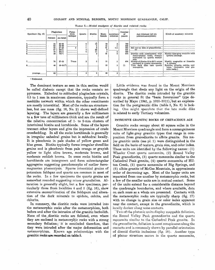
40 GEOLOGY AN:D MINERAL DEPOSITS, MOUNT MORRISON QUADRANGLE, CALIF.
TABLE 5.-ModaZ analyses of diorite and related rocks
Plagioclase Potas- Number Specimen (fig. 16) 1 ___ ,....._ __ 1 sium Quartz Biotite
feldspar Hom- Accessory of Age relations (all are
postmetamorphism) Kinds or accessory minerals
blende minerals counts Percent An range
-------1--------------------------1----------l----------! __________________ _
2.------------------3-------------------4-------------------5-------------------6-------------------
7-------------------8.------------------
54 35-65 82 50-60 50 37-55 67 . 30(?} 70 30(?) 58 70(?)
76 37-55 Trace
19 . 5 3
20 17 2
40 50-65(?) ---------- ---------- ----------
18 11 41
9 5
31
11
55
3 1
<I
(1)
783 ---------------------------------- --------------------------------593 565 ·sificlii-t"Y<ii'keor-iraD.o<iiorite~= ============================ == = = 431 _____ do __ ------------------------ --------------------------------
~tg ·nioriiic-rock-iD.ieria:Yered.-"Witii- -M:os-tiy-biue:gray-iiiet.aiiic-wiiil metavolcanic rocks, sharply sphene coatings. truncated by quartz monzo-nite.
494 Masses of diorite 10 to 20ft across Mostly magnetite or ilmenite enclosed in quartz monzonite. + sphene.
Thin dark dike cuts quartz Epidote, chlorite, calcite, and monzonite. mica. (Intrusive into gra
nitic rocks.) -----------------------------------1----------
Average______ 62 ---------- ---------- 3 9 23 3 ---------- ---------------------------------- --------------------------------
1 Estimated.
The dominant texture as seen in thin section would be called diabasic except that the rocks contruin no pyroxene. Euhedral to subhedral plagioclase crystals, 0.5 to 1 mm in m·aximum dimension, typically form a meshlike network within. which the other constituents are mostly interstitial. Most of the ·rocks are structure- . less, but one mass (fig. 16, No. 2) shows well-defined layer~ng. · The layers are generally a few mHliineters to a few tens of millimeters thick and are the result of the t::elative concentration of 1- to 2-mm clusters of interinixed biotite ;and hornblende. So;rne o'f the layers transect other layers and. give the impression of crude crossoedding. In aU the rocks horn.blende is ·generally in irregular anhedral gra·~ns but is subhedral locally. It is pleochroic in pale shades of yellow green and blue green. Biotite typically forms irregular shredlike grains and is pleochroic from pale orange or grayish yellow -to light olive · brown, moderate brown, and modera.te reddish brown. In some rocks biotite and hornblende are intergrown and form subi'ectangillar aggregates suggestipg pseudomorphs of earlier _ferromagnesian phenoc~ysts. · Sparse interstitial grains. of potassium feldspar. and quartz are common in .most of the rocks. In a few speclmens the quartz grains are so~ewhat rounded suggesting minor granulation. Alteration is generally slight, but a few specimens, particularly those :from localities 4 and 5 (fig. 16),, show extensive saussur1tizatimi. of the feldspars and alte·ration of the dark minerals to epidote, calcite, and chlorite.
In summary, the dioritic rocks were intruded into the metamorphic rocks after the metamorphism, both before and after the intrusion of the granitic batholith. None. of the~ ~ dioritic rocks ar~ foliated, even where they are enclosed in metamoq_)~ic rocks with a strong secondary :foliation;' it' is con'Cllided therefore, thatthey were intruded after the·' major deformation and metamorphi~m.., l{nqwn age relationships with the granitic rocks are -reCorded on table 5.
Little evidence. was found in the Mount J\1orrison quadrangle that sheds any light on the origin of the diorite. The dioritic rocks intruded by the granitic rocks in general fit the "basic forer~nner" type described by Mayo ( 1941, p. 1010-1011); but an explanation for the postgranitic dike (table 5, No. 8) is lacking. One might speculate that the late mafic dike is related to early Tertiary volcanism ..
INTRUSIVE GRANITIC ROCKS OF CRETACEOUS AGE
Granitic rocks occupy about 40 square miles in the Mount Morrison quadrangle and form a consanguineous suite of light-gray granitic types that range in composition from granodiorite. to albite granite. Six major granitic units (see pl. 1) were distinguished in the field on the basis of texture, grain size, and color index. These units are identified by the following names : ( 1) "Wheele.r Crest. quart~ monzonite, (2) Round Valley Peak granodiorite, ( 3) quartz monzonite similar to the Cathedral Peak granite, (4) quartz-monzonite of Hilton Creek, ( 5) quartz monzonite of Big Springs,. and (6) albite granite -of McGee Mountain, in approximate order of decreasing age. Most of the larger units are ·separated from one another by metamorphic rocks, but a few of ·the smaller units are in mutual contact. Some of d1e. units extend for a considerable distance beyond the quadrangle boundaries, and wher~ available, data
. on each mass as a whole are presented. Contacts with the ~etamorphic rocks are . typically sharp (fig. 17) with no change in grain size or color index app;arent ne~r the C()ntact, except in the granodiorite, which is local1y darker along some contacts. ·-Two of the plutonic units display mappable foliation, the Rotmd Valley Peak granodiorite and the quartz l1191)ZOnite similar to the Cathedral P~ak granite. In tl1e. granodiorite, foUation is most· conspicuous along the contacts nncl is commonly shown by parallel orientation of discoid dioritic inclusions (.fig. 18). Another type of planar structure occurs in the quartz monzonite, .
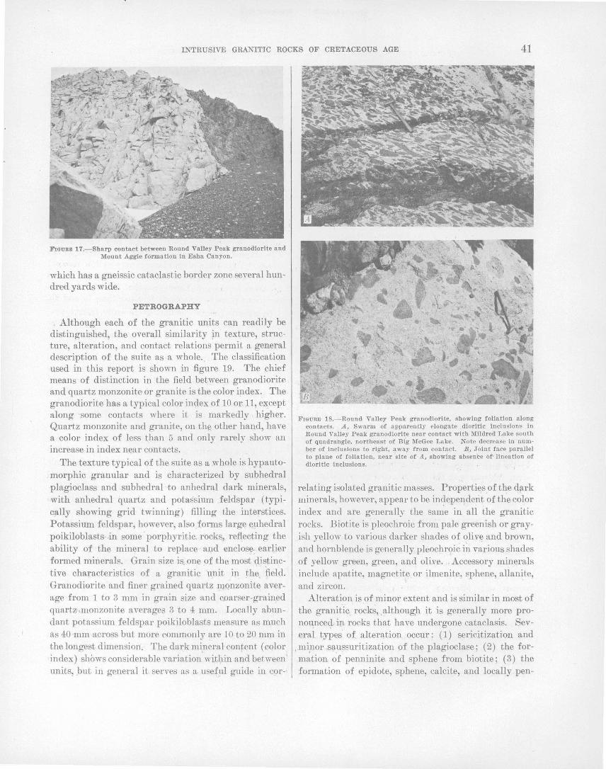
INTRUSIVE GRANITIC ROCKS OF CRETACEOUS AGE 41
FIGURE 17.-Sharp contact between Round Valley Peak granodiorite and Mount Aggie formation In Esha Canyon.
which has a gneissic cataclastic border zone several hundred yards wide.
PETROGRAPHY
Although each of the granitic units can readily be distinguished, the overall similarity ~n texture, structure, alteration, and contact relations permit a general description of the suite as a whole .. The classification used in this report is shown in figure 19. The chief means of distinction in the field between granodiorite and quartz monzonite or granite is the color index. The granodiorite has a typical color index of 10 or,ll, except along some contacts where it is markedly higher. Quartz monzonite and granite, on the. other hand, have a color index of less than 5 and only rarely show an increase in index near contacts.
The texture typical of the suite as a whole is hypautomorphic granular and is characterized by subhedral ·plagioclass and subhedral ·-to anhedral dark minerals, with anhedral quartz and potassium feldspar ( typically showing grid twinning) filling the interstices. Potassium feldspar, however, also forms large e11hedral poikiloblasts· .in some · porphyritic. rocks~ reflecting the ability of the mineral to replace and enclosY; earlier formed minerals. Grain size is_ one of the most <,li~tinctive characteristics of a granitic u_nit in the, field. Granodiorite and finer grained quartz mqnzonite average from 1 to 3 mm in grain size and c.oarser-grained quart;1 .monzonite averages 3 to 4 mm. Locally abundant potassium feldspar poikiloblasts measure as much as 40 ·mm across but more commonly are 10 to 20 mm in the longest dimension. The dark mineral content (color index) shows considerable variation' within a~d between' units, .but in general it serves as a usef:ul guide in cor-•
FIGURE 18.-Round Valley Peak granodiorite, showing foliation along contacts. .A, Swarm of apparently elongate dioritic inclusions In Round Valley Peak granodiorite near contact with Mildred Lake south of quadrangle, northeast of Blg McGee Lake. Note decrease in number of inclusions to right, away from contact. B, Joint face parallel to plane of foliation, near site of A, showing absence of• lineation of dioritlc inclusions.
relating isolated gr~nitic masses. PropertiE\s.of the q~rk minerals, however, appear to be in~ependerit of the color index and are generally the same in all the granitic rocks. Biotite is pleochroic from pale greenish or grayish yellow to various darker shades of ~live and brown, and hornblende is generally pleochr<;>ic in various shades of yellow green, green, and oli:ve. . Accessory minerals include apatite, magnetite or ilmenite, sphene, allanite, and zircon. '
Alteration is of minor extent and is similar in most of the granitic rocks, although it is generally more pronoupce9-• i.rl rocks that have undergone cataclasis. Several types of alteration occur: (1) sericitization and
,.mi,nor,s\1-u:;suritization of the plagioclase; (2) the formation of penninite and sphene from biotite; (3) the formation of epidote, sphene, calcite, and locally pen-

42 GEOLOGY AND MINERAL DEPOSITS, MOUNT MORRISON QUADRANGLE, CALIF.
Plagioclase 10 35
Quartz
65 Potassium feldspar (includes perthite)
FIGURE 19.-Classlftcatton of granitic rocks used in this report. (Dia.gram modified after Johannsen, 1931.)
.ninite from hornblende. The cores of some plagioclase crystals show pronounced· alte~ation to a light-brown dense aggregate of probable clay minerals; veins of similar material locally cut otherwise unaltered rims of plagioclase crystals. Myrmekite is sporadically distributed through most of the rocks, either as continuous rims around plagioolase crystals enclosed in potassium feldspar, or as bulbous protrusions from plagioclase grains into potassium feldspar.
The paragenesis as interpreted from the texture indicates that plagioclase and hornblende were probably the first minerals to crystallize. Biotite also appears to have crystallized early, as indicated by its common intergrowth with hornblende, although the intergrowth may result, in part, from replacement of hornblende by biotite as crystallization proceeded. Quartz and potassium feldspar fill the remaining interstices, but quartz probably overlaps ~ith the earlier minerals as indicated by the many large, although anhedral, crystals. Potassium feldspar was the last mineral to crystallize and forms stringerlike interstitial masses and, locally, euhedral poikiloblasts.
PRES.ENTATION OF MODAL DATA
Modal analyses of thin sections were made using a mechanical stage adapted for counting points ( Chayes, 1949) and are recorded in table 6. In order to cover the entire slide without counting a prohibitive number of points, only alternate points in alternate rows were counted, which resulted in a spacing between points of 0.67 mm in one direction and 1.0 mm in the other.
For the coarser-grained rocks, particularly the quartz monzonite of Cathedral Peak type, a thin section does not provide a large enough sample for a representative modal analysis. .Modes of coarser grained rocks can be determined from slab surfaces that are etched with HF
fumes, then stained with sodium cobaltinitrite to distinguish the potagsium feldspar, and finally covered with dot-pattern Zip-A-Tone in the manner outlined by Jackson and Ross (1956). Unfortunately the slab technique could not he adequately tested on the coarse-grained quartz monzonite of Cathedral Peak type, as mpst specimens were collected before the technique was developed and were too small to make suitable slabs. Nevertheless, two specimens from this unit were prepared, in this manner, with slab surfaces from 3 to 4 inches square. In order to test the sampling, two slabs from each specimen were analyzed, and the analyses recorded on table .6, Nos. 1a, lb, 2a, and 2b. The quantitative difference between each a and b specimen reflects inhomogeneity of the rock, assuming that the method of analysis is reliable. (See Jackson and Ross, 1956.) The stained slabs present striking color contrasts between chalky white plagioclase, canary yellow potassiu.m feldspar, gray quartz, and black biotite, and it was apparent from a rapid appraisal that 1b and 2a contain significantly more potassium feldspar than 1a and 2b.
In order to present the data graphically, quartz, plagioclase, and potassium feldspar were recalculated to 100 percent and a point plotted on a triangular dia:gram (figs. 20, 21, and 22) for each mode in the manner described by Johannsen (1931, p. 152-153). In addition, the significant part of a triangle showing the abundance of hornblende and biotite, and hence the color index of the specimens accompanies the larger diagrams. Each of the modes and the points plotted on the triangular diagrams are keyed to -an index map of the granitic rocks show!ng the location of each specimen (pl. 3).
The precision with which modes should be recorded is a subject of controversy. The essential point of dispute is whether the recording of data from modal analyses to the nearest tenth of a percent and of chemical analyses to the nearest hundredth of a percent is a violation of the principle of significant figures (Fairbairn and others, 1951; Hamilton, 1952) or whether it is the justifiable recording of observed data ( Chayes, 1953). The writers feel that recording the modes of this suite to more than the nearest· percent gives a false. impression of the accuracy· of a point count and hence its reproducibility. With duplicate analyses, the percentage of. major constituents could generally be reproduced with limits of 1 to 1.5 percent with a maximum discrepancy in one specimen of 3 percent; the maximum discrepancy in the dark mineral content was 2 percent. Similar variations in duplicate analyses were found in a test conducted by Chayes and Fairbairn (1951) to determine the precision of thin-section analysis by point counter. ·In this test five persons counted each of five

Specimen
I Percent
l ___ --- ------------ 38 2 •• ---------------- 60 3 •• ---------------- 65 4.----------------- 45 5.----------------- 46 6.----------------- 46 7------------------ 42 8.----------------- 46 9.----------------- 42 10.---------------- 48 11 •• --------------- 42 12.---------------- 31 13.---------------- 40 14.---------------- 43 16.---------------- 40 16 •• --------------- 60 17----------------- 66 18.---------------- 42 19 ___ -------------- 60 20.---------------- 42 -----Average _____ 46
l_ _________________ 63
2.-----------.----- 35 a_----------------- 67 4 __ ---------------- 40 5 •• ---------------- 4a 6------------------ 43 7------------------ 40 8.----------------- 29 9 ___ -- ------------- 42 10 ___ -------------- 45 1 l_ ________________ 51 12 ••• -------------- 60 I a.-------"-------- 51 ----
INTRUSIVE GRANITIC ROCKS OF CRETACEOUS AGE
'I'AnLE 6.-Modal analyses of the granitic rocks (Tr=<1 percent. Location of specimens given on pl. 3]
Plagioclase Potassium Quartz Biotite Hornblende Accessory feldspar minerals
An range
Round Valley Peak granodiorite, Lee Lake mass
25-44 •• ---------------------- 20 29 10 3 1 ------------------------------ 14 25 10 Tr 1
-2&:33::::::: ::::::::::::::::: 15 16 9 5 1 14 Zl 9 4 1
24-43_ ----------------------- 13 26 13 Tr 1 28-1 66 _______________________ 15 26 9 4 Tr
------------------------------ 13 Zl 14 2 1 ------------------------------ 16 28 7 2 Tr
-27-=44:::: :::::::::::::::::::: 17 32 9 ------------ 1 18 27 6 Tr
------------------------------ 21 25 11 Tr
-24=-ii::: ::::::::::::::::::::: 29 34 6 ------------ J 1 20 26 7 5 1
------------------------------ 18 31 5 1 1 ---------- .. ------------------- 25 28 6 1 1 ------------------------------ 14 22 8 5 1 ------------------------------ 11 20 3 5 1
-24=46:::::::::::::::::::::::: 18 26 12 ------------ 2 14 Zl 5 1
23-46.----------------------- 25 26 4 2
.. ----------------------------- 17 26 8 2
Round Valley Peak g...nodlorlte, Roc:k Creek mass
-2Ho:::::::::::::::::::::::: 1 25 13 Zl 30 4
8 ------------2 2
26-46 ____ -------------------- 6 22 8 6 1
-2Ho:::::::::::::::::::::::: 21 26 8 22 28 5
4 1 a Tr
-2ii=4o:::::::: :::::::::::::::: 19 28 8 22 Zl 8
2. Tr 3 Tr
-2Ho:::::::::::::::::::::::: 24 37 9 17 29 7
1 Tr 2 3
28-42.----------------------- 18' 25 7 4 1 al-40.- ---------------------- 17 17 9 6 25-40.----------------------- 13 22 9 6
---------------- .. -.. ----------- 17 19 7 6
Number or counts
800 5Zl 634 621 649 613 675 477 497 755 704 530 569 682 510
2.303 656
·1, 139 417 624
------------
425 1,206
691 660 511
1,480 839 583 676
1, 572 512 598 487
Average _____ 46 -.. ---- .... ----- .................. -------- 17 26 11 ------------ ------------
Wheeler Ciest Quartz monzonite
1__________________ al 3()-40 ____________ ~----------- 21 a9 6 2------------------ a1 25-35------------------------ Zl 32 3------------------ 43 30 ••• ~----------------------- Zl 27
1g :::::::::::: --------Tr-4------------------ a6 ------------------------------ 26 30 8 ------------ ------------5------------------ 39 ------------------------------ 18 35 8 ------------ 1 , ____ ,
678 3 4,000
576 451
1,043
Quadrangl~
Mount Morrison. Do. Do. Do. Do. Do. Do. Do. Do. Do. Do. Do. Do. Do .. Do.· Do. Do. Do. Do. Do.
Mount Morrison. Do. Do. Dol Do. Do. Do. Do. Do. Do.
Casa Diablo Mountain. Do. Do.
Mount Morrison. Do. Do. Do. Do.
43
Average_____ 86 ------------------------------ 24 33 7 Tr Tr _____________________ ----- __ ------------------1=======1======1=======1=======1======1======1===================
1.------------~----- 27 42--------------------------- 29 38 6 ------------ ------------ 557 Casa Diablo Mountain (Sierra). 2------------------ 28 ------------------------------ 35 35 2 ------------ ------------ 545 Do. a------------------ 44 25-40________________________ 32 21 3 ------------ ------------ 598 Do. 4------------------ 20 ------------------------------ 29 48 3 ------------ ------------ 537 Do. 5------------------ 29 ------------------------------ 30 37 4 ------------ ------------ 589 Do. 6------------------ 24 30--------------------------- 33 39 4 ------------ ------------ 616 Do. 7------------------ 30 22-27------------------------ 42 25 3 520 Do. 8------------------ 33 22-31.----------------------- Zl 33 3 ------------ -------·-;a· 537 Do. 9------------------ 36 26--------------------------- 18 39 7 ------------ --~--------- 517 Do.
~~::::::::::::::::: ~ ·20::::::::::::::::::::::::::: g: ~ ! ------------ ------------ 1, ~~ B~: 12-~--------------- 24 ------------------------------ 46 ZT 2 -------·-r:rr-· --------Tr- 636 Do. 13_________________ 24 38 37 1 583 Do. 14_________________ a7 "iS:2ii::::::::::::::::::::::::. 25 32 6 :::::::::::: --------Tr- 638 Do. liL---------------- 45 26-30 ••••••• ·----------------- 28 25 a ------------ Tr 517 Do. 16_________________ 38 ------------------------------ 24 30 8 ------------ 1 511 Do. 17----------------- 34 ------------------------------ 21 42 2 ------------ 1 657 Do. I--------I-------------------I·-------I----------I--------I----------I·----------I--------1-----------------------
4 ------------ ------------ ------------ ----------------------------------Average..... 31 --------.--------------------- at . 34 1 ; --------- ________ l===.=3=4=l 33-45 ________________________ I====17=I====20=I====12=I:====1=6 =l=====l====5=18=l==c=as=a=D=ia=b=lo=M=o=un=t=ain=(=B=e=n=to=n
2------------------ 48 25-37------------------------ 11 25 5 '9 2 633 Range)
a------------------ 51 25-40________________________ 7 23 7 11 1 Do. 4------------------ 60 32-47________________________ 8 21 1 1a 1 --------iiis- Do. 5------------------ 42 23-37------------------------ 26 25 2 4 1 . 558 Do. 6------------------ 53 30-45·----------------------- 18 8 6 14 1 1, 654 Do. 1----------------~- 38 35--------------------------- ao 24 4 5 ------------ 533 Do. 8------------------ 68 ------------------------------ 13 15 4 9 1 995 Do. 9----~------------- 56 ------------------------------ 13 11 10 .10 ------------ ------------ Do. 10_________________ 40 ------------------------------ 15 a4 6 . 3 2 560 Do. 11----------------- 54 . 10 24 8 3 1 581 Do. 12----------------- 57 "2&:87:::::::::::::::::::::::: 11 20 8 2 2 515 Do. 13_________________ 40 ------------------------------ 26 28 4 ------------ 2 534 Do. 14----------------- a1 ------------------------------ 29 a6 4 ------------ ------------ li55 Do. 15----------------- 36 ------------------------------ 21 37 6 ------------ ------------ 612 Do.
Average ____ _ 46 ------------------------------
See footnotes at ~nd of table. 689-998 0-64--4
17 23 6 1 ------------ ---------------- ~- ----------------

44 GEOLOGY AND MINERAL DEPOSITS, MOUNT MORRISON QUADRANGLE, CALIF.
Specimen
la ________________ _ 1 b ____ - ------------2a •• ______________ _ 2b _____________ ----
3.-----------------4 __ --- -------------5.-----------------6.-----------------7------------------8.-----------------9.----------- -·--- --10.----------------
Percent I
Plagioclase
TABLE 6.-Moilal OJnalyses ot the uranitic rocks-Continued [J'r=<l percent. Location of spectmeP.s given on pl. 3]
Potassium Quartz Biotite Hornblende Accessory feldspar minerals
An range
Quartz monzonite similar to the Cathedral Peak Granite 4
40 ------------------------------ 29 33 30 25 18 25
25 29 29 30 26 29 34 17 36 37 41 29
6 ------------ ------------34 37 41
-53 42 51 36 36 29 42 46
Io-18. __ --- ______ -- _______ ---
27---------------------------7
44 25 33 15 17
5 ------------5 ------------5 ------------2 ------------2 Tr 7 ------------2 ------------4 ------------1 ------------3 ------------5 ------------
------------------------------------
Tr Tr
1 1
Tr ------------
Tr 23
Number Quadrangle of counts
5 3,023 Mount Morrison. 5 2.243 Do. 5 1, 614 Do. 5 2,090 Do.
515 Do. 544 Do. 567 Do. 697 Do. 674 Do. 789 Do. 567 Do. 783 Do.
Average 6 __ _ 39 ------------------------------ 29 5 ------------ Tr ------------
L _________ --------2.-----------------a ___ ---------------4.-----------------5.------ __ . ___ ------
Albite granite of McGee Mountain
25 5-------------~-------------- 38 34 (Albite)_____________________ 30 40 (Albite)_____________________ 13 58 (Albite}':: _____ ~-------------- ------------29. (Albite)_____________________ 31
35 34 46 42. 36
2 ------------2 1
Tr 4
Quartz monzonite of Hilton Creek
Tr
L-----------------1 2.-----------------41 I 3276·.1 ·2 1------------1------------1 26 3 ------------ ------------
1.---------------- -I 2.-----------------I Local calcic cores in plagioclase. 2 Epidote. 3 Average of four 1,000-point counts on slab 1 ~ e· inch by 3 inch. • Grain size probably too large for-accurate samples of 3-10. 5 Point counts on etched and stained slabs. 6 Weighted (1 part each for 1a, lb, 2a, 2b, 3-10)=5 parts.
Quartz monzonite of Big Springs
271 30 I 4.·1------------1---~--------1 27 29 4 ------------ ------·------
. '
7 1 mile northeast of locality of specimen 2 (not shown on plate 3). ·
722 . Mount Morrison. 530 Do. 470 Do. 444 Do. 788 Do.
7271. Mount Morrison. 766 Do.
6031 Mount Morrison. 606 Do. .• .
thin sections cut from the same hand specimen. Varia~ tions in essential ·constituents ranged from 0.6 to 4.8 percent with an average of 2.5,percent.
within the Mount Morrison quadrangle. and extends southeastward from Mammoth Rock to about 1,500 feet
ROUND VALLEY PEAK-GRANODIORITE
The ~ound Valley Peak granodiorite crops out in' four adjoining.15-minute quadrangles, the Mount Morrison, Casa Diablo Mountain, Mount Tom, and Mount
· south of the quadrangle boundary near Lee Lake. ·The third mass is exposed over.an area of 2 square miles on the northern slope of Laurel Mountain between,Laurel and Con viet Creeks and, for convenience in the ensuing discussion, is included with the Lee .Lake mass.
Abbot quadrangles, and covers an area of about 54 ROCK CREEK MASS
square miles. The rock is named for a high peak on In the Modnt Morrison quadrangle the Rock Creek Wheeler Crest in the Mount Tom quadrangle near the mass crops out over an area of 35square miles and com.southeast end of the outcrop area (pl. 3). Excellent prises about two-thirds of the are_p, covered qy the enexposures are readily accessible along upper Roek Creek tire uriit. TJie_ mo~t -distinct field charaeteri~tics of the in the Mount Tom quadrangle. The unit is composed rock ,a,re the uniform grain size (2 to 3 mm) ~nd_ tlie of three masses separated by metamorphic rocks. The . t~xture cl).aracterized by prominent equant to slightly southernmost and largest mass, designated the R()({k elongate sl)bhedra1 plagioclase crystals an.d subhedral
·'Creek mass, crops out in the form of a crescent open to! to euliedral biotite plates.. This texture ·is most conthe southwest and extends into all four quadrangles. .. spicuous in darker colored varietie.s (color index of 10 The name "Rock Creek" was first applied to t4e mass; · or more) . exposed in the Casa Diablo Mountain quadrangle: ·• An.other diStinctive .. feature of the mass is the com~7 (Rinehart and Ross, 1957), and was later used by Sher-:
1: -~ mon ~ccurrence of dark-gray fine-grained dioritic dis
~ock and Hamilton (1958) for contiguous expos,ures in ·' coid i.ndusions that range in size from a few inches t~ the Mount Abb9t quadrangle. The mass also extends: .; a foot'· or mo-re in ·_diameter and are generally n1ore into the Mount Mbrrison quad,rapgle, but exposures are' numer-ous near contacts. ~oeal flatt~ning and parall~l interrupted by glacial deposits along Hilton Creek. orientation of the inclusions produces a prominent The next largest mass,· desigr}ated the Lee Lake mass: folia~ion. The planar orientation of inclusions is best (after Sherl6ck.and Hamilton, 1958), is aliriost·wholly seen north of Big McGee Lake, about: ha1f a mile

INTRUSIVE GRANITIC ROCKS OF CRETACEOUS AGE 45
south of the quadrangle boundary in the Mount Abbot quadrangle. There the contact with the Mildred Lake hornfels is ma,rked by swarms of well-alined inclusions that locally make up as ·much as 50 percent of the· outcrop (fig. 18). The foliation parallels the contact and also is almost conformable with schistosity in the l\{ildred Lake formation. Joint planes, locally ·coincident with the plane of foliation, show that the in- . cl usions are discoid a;nd are not elongate (fig. 18) . · Similar, but less well-defined foliation, occurs at other localities, particularly along the contact with the Mount Morrison pendant.
EXPLANATION
Mount Morrison and Casa Diablo Mountain quadrangles
+ Mount Tom quadrangle
A Average mode
0 Norm of specimen 5
Numbers refer to specimens analyzed in table
Plagioclase
Other constituents
Quartz
/' I \ I \
-Plagioclase Potassium INDEX feldspar
Potassium feldspar
ROCK CREEK MASS
EXPLANATION I I I
Rock Creek mass
I - I
As shown by the modal analyses in table 4, the ratio of plagioclase to potassium feldspar is typioally 2: 1 or slightly greater with the conspicuous exception of specimens 1 and 3, which have ratios of more than 9: 1. Both specimens were collected close to the metasedimentary contact, and, as might be expected from the .feldspar ratios, both have an exceptionally high color index. The occurrence of m·afic material along the
. niargins of the intrusive, however, is sporadic as shown by specimen 9. This specimen was collected close to the contact in an area where diorite and dioritic inclusions ~re abundant, but its composition is average in all constituents ..
EXPLANATION A
Average mode
0 Norm of specimen 16 Numbers refer to speci
mens analyzed in table
Other constituents
Quartz
/' .12 / \
I \
Pll:lgioclase
Jilllllll~ Plagioclase · Potassium
INDEX feldspar
Potassium feldspar -
LEE LAKE MASS
Lee Lake mass - I ~ -1 -
-- l~~tT~~ I -... Averages .
Norms I • -~ e
COMPOSITE PLOT
Potassium feldspar
rFJOunm 20._:_Round V'nlley Peak 'granodiorite--graphic representation' of modes. Data from the :M:ourit Tom quadrangle supplied by P. C. Buteman (written communication 1958): Numbers refer to'specimens gh:en in table 6.
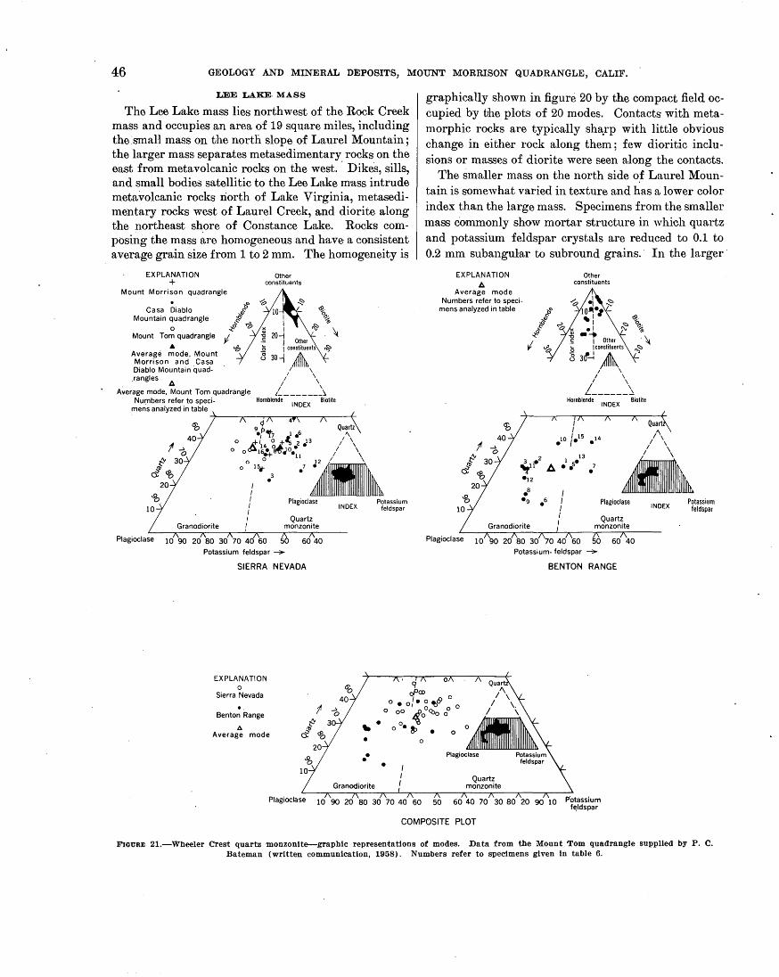
46 GEOLOGY AND MINERAL DEPOSITS, MOUNT MORRISON QUADRANGLE, CALIF.
LEE LAKE· MASS
The Lee Lake mass lies northwest of the Rock Creek mass and occupies an area of 19 square miles, including the small mass on the north slope of Laurel Mountain; the larger mass separates metasedimentary. rocks on the east from metavolcanic rocks on the west. Dike8, sills, and small bodies satellitic to the Lee Lake mass intrude metavolcanic rocks riorth of Lake Virginia, metasedimentary rocks west of Laurel Creek, and diorite along the northeast shore of Constance Lake. Rocks composing the mass are homogeneous and have· a consistent average grain size from 1 to 2 mm. The homogeneity is
EXPLANATION +
Mount Morrison quadrangle
Casa Diablo Mountain quadrangle
0 Mount Tom quadrangle .. Average mode, Mount Morrison and Casa Diablo Mountain quad-.rangles 1:1
A~erage mode, Mount Tom quadrangle Numbers refer to speci-
mens analyzed in table
Other constituents
I I I
20) Other
l5 1 constituents ~
8 30-1 ~ I \
/ \ / \ '--------~
Hornblende INDEX Biotite
Q 4 60
40 ~~
9•f't7 1 .6 "
o A+/14 ~_i'~ i •13 / \
0 ~ 30
d'Ob 20
Plagioclase
o oo-&16• ~JOe I \ e+ 11 / \
0° ,;_, •' -~ Plagioclase Potassium
INDEX feldspar
Potassium feldspar ~
SIERRA NEVADA
EXPLANATION 0
Sierra Nevada .. Benton Range
.6. Average mode
Plagioclase
60 40
10 90 20 80 30 70 40 60
graphically shown in figure 20 by the compact field occupied by the plots of 20 modes. Contacts with metamorphic rocks are typically sha:,rp with little obvious change in either rock along them; few dioritic inclusions or masses of diorite were seen along the contacts.
The smaller mass on the north side of Laurel Mountain is somewhat varied in texture and has a lower color index than the large mass. Specimens from the smaller mass commonly show mortar structure in which quartz and potassium feldspar crystals are reduced to 0.1 to 0.2 mm subangular to subround grains. · In the larger ·
EXPLANATION 1:1
Average mode Numbers refer to speci
mens analyzed in table
Other constituents
Quart
;" I \
3 2 ~1l. !:A .12
.a
I \
·~ Plagioclase 10
.9 .6 Plagioclase
Quartz monzonite
~6 6d\o Potassium- feldspar ~
BENTON RANGE
50 60 40 70 30 80 20 90 10 Potassium f~ldspar
INDEX Potassium
feldspar
COMPOSITE PLOT
FIGURE 21.-Wbeeler Crest quartz monzonite--graphic representatiQns of modes. Data from the MQunt TQm quadrangle supplied by P. C. Bateman (written communication, 1958). Numbers refer to specimens given in table 6.

INTRUSIVE GRANITIC ROCKS .OF CRETACEOUS AGE 47
EX PLANATION •
Quorlz monzonilo·similar Ia lhe Calhedrol Peak gronilo
&. Av:{~~:r m1~d~h~uc~l~e~~0~z~~i~:
gronile
+ Quorlz monzonile of Hillon Creek
0 Albilo granilo of McGee Mounloin . Quorlz monzonilo of Big Springs
Numbers refer to specimens analyzed in table
Plagioclase
Other constituents
I I I ">
s-l :i ~~~-
to~:i 1> 180ther' \
15jco~nts ~
/' '\ I \
I \ L-------~
Hornblende INOEX Biotite
40 60 50 60 40 70 30 80 20 90 10 Potassium feldspar
FIGURE 22.-Quartz monzonite s1mila.r to the Ca.tihedra.l Peak granite and smaller felsic mnsses-grnphlc representation of modes. Num·bers refer to specimens gl ven ln table 6.
mass, undulatory extinction in the quartz and· sparse mosaic structure n.re the only catn.clastie effects.
UELATIONSHIP BETWEEN THE ROCK CREEK AND LEE LAKE MASSES
Although the grn.nodiorite masses are physically separated by metan1orphic rocks, they are inferred to have crystallized from the same parent magma because of the remarkable similarity of the Lee Lake and Rock Creek masses in both chemical and quantitative mineralogic composition, as shown by figure 20 and table 1. The similarity of the modes is shown in figure 20 by the almost complete overlap of the fields defined by each of the masses (fig. 20) when plotted on a single di~tgram (fig. 20). The rocks of the two masses also resemble en.ch other .in the field although subtle differences can be detected. The avern.ge grain size in t;he Lee Lake mn.ss ( 1 to 2 mm) is smn.ller than that in the Rock Creek mass (2 to 3 mm), and although the difference is slight, it is sufficient to permit a heterogeneous group of specimens of both masses to be sorted into their proper respective groups. The only other difference involves the mafic inclusions, which are common in the Rock Creek mass and uncommon in the Lee Lake mass.
QUARTZ MONZONITE AND GRANITE
WHEELER CREST ,QUARTZ MONZONITE
The Wheeler Crest quartz monzonite is known to underlie about 25 square miles in the Sierra Nevada, principally in the Mount Tom and Casa Diablo Mountain quadrangles (pl. 3); less than a square mile is e~osed in the l\1ount Mori;ison quadrn.ngle, chiefly in. McGee mountain. A probable correlative of the Wheeler Crest
TABLE 7.-0herrvioal OIIWlyses Qlnd norms, in weight percent, of the Round Valley Peak granodiorite
(Analyses are by the rapid method (Shapiro and Brannock, 1956) Analysts: K.E · White, P. L. D. Elmore, P. W. Scott]
Chemical analyses
Rock mass and field and laboratory. (in parentheses) Nos.
~e Lak£>mass Rock Creek mass
M-739 (1440~7) M-550 (144086)
SlOt.--------------------------------------------- 65. 1 . 68. o AhOs •• -------------------------------------------- 16.6 15. 6 FeaOa.-------------------------------------------- 2. 3 1. 8 FeO __ -------------------------------------------- 2. 4 1. 8 MgO •• -------------------------------------------- 1. 8 1. 5 cao_ ------------·--------------------------------- 4.1 3. 6 NatO .• •------------------------------------------- 3. 4 3. 4 KtO-- -------------------------------------------- 3. 2 3. 4 TiOt---------------------------------------------- . 48 . 38 PtOa. --------------------------------------------- . 19 . 15 MnO .••••••• -------------------------------------- . 09 . 08 H·so _ --------------------------------------------- . 48 . 40 co, _____ ·------------------·----------------------- <. o5 <· o5 1-----------1----------TotaL _________________________________ ------ 100 100
Norms
qtz .... -------------------------------------------- 20.8 24.8 or._-----------------------~----------------------- 18.9 20.0 ab ..••. -------------------------------------------- 28.8 28.8 aD-----·------------------------------------------- 20.3 17.2 (Anu) (ADa7) diop.___ _ _ _ _ __ _ _ _ _ _ _ _ _ _ _ __ _ _ _ _ _ _ _ _ _ _ _ _ _ _ _ _ _ _ _ _ _ __ _ _ _ _ _ _ _ _ _ _ _ _ _ _ _ _ _ _ . 5
byp_- --------------------------------------------- 6. 2 4. 8
~~t_-_-=:::::::::::::::::::::::::::::::::::::::::::: a:~ ------------"i6 ilm .. ----------------------------------·------------ . 9 . 8
TotaL._------------------------------------
Specific gravity (powder>------------·-----------Specific gravity (lump)_--------------------------
1----------·1---------99.3
2. 72 2.64
99.5
2. 70 2. 60
Specimen localities: M-739. 1 mile east or Lake Virginia (No. 16 on table 4, figure 20, and plate 3). M-550. 3,500 rt. northeast or Steclbead Lake (No. 5 on table 4, figure 20 and
plate 3).
underlies an additional 10 square miles in the Benton Range in the Casa Diablo Mountain quadrangle and is also shown on plate 3. The rock is named for a massive northwn.rd-trending ridge that crosses the boundary between the Casa Diablo Mountain and the Mount Tom quadrangles and forms the steep eastern face of the Sierra Nevada in this area. The rock is exposed in outcrops near the ~mouth of Rock Creek (Rinehart and Ross; 1957), but the best and most typical exposures occur along the upper parts of Wheeler Crest. The following is a description of the typical rock as exposed on Wheeler Crest in the Mount Tom quadrangle (P. C. Bateman, written communication, 1959) :
The typical rock on "rheeler Crest is porphyritic and contains tabular phenocrysts of potassium feldspar which are set in a medium-grained hypi9iomorphic granula~r groundmass. The groundmass minerals commonly range from 2 to 4 mm across and the pbenoc:tysts average about half an inch thick and range from 1 inch to several inches in maximum dimension. Fresh surfaces are light gray, and the color index averages about 7,, but ranges froni a little less than 5 to a little more than 9. By decrease in the abundance of phenocrysts, porphyritic rock

48 GEOLOGY AND MINERAL DEPOSITS, MOUNT MORRISON QUADRANGLE, CALIF.,
grades into equigranular rock which has a texture identical with that in the groundmass of porphyritic rock. The dark minerals, biotite and hornblende, are evenly scattered in small clusterS through the rock but with concentrations along the margins of phenocrysts. Individual grains are small, generally less than 1 mm across, and anhedral.
Locally the quartz monzonite contains irregular fine-grained dark-colored aggregates as much as 1 inch in the greatest di- · mension, which consist chiefly of biotite plates with lesser amounts of accessory minerals. These aggregates are thought to be small inclusions of schist or pelitic hornfels. Some of them are enclosed in plagioclase grains.
In most places the quartz monzonite has a primary foliation that is marked by planar orientation of ovoid clots of mafic minerals and by tabular mafic inclusions. In a few places a secondary gneissic foliation is shown by layers of hornblend~ and biotite that lie along closely-spaced shears, and which presumably owe their orientation and distribution to metamorphic differentiation.
In the Mount Morrison quadrangle the mass exposed on McGee Mountain, the largest in the ·quadrangle, is generally deeply weathered. The typical gray color of the fresh rock is masked by moderate-reddish-brown stain, not only on exposed surfaces but also on rock taken a few feet below the surface. The feldspar pheno·crysts commonly weather in relief to give the exposures a knobby surface. Smaller exposures at the head of Esha Canyon and along Hilton Creek are not as deeply weathered and ~re dominantly gray and somewhat splotchy because of the irregular distribution of dark minerals.
The McGee Mountain mass contains large euhedral crystals of potassium feldspar and appears megascopically porphyritic, but in thin section the texture can be seen to be seriate porphyritic. In exposures to the south, however, phenocrysts are less common, partly because they have been destroyed by cataclasis. In the porphyritic rocks the potassinm feldspar phenocrysts measure as much as 20 mm across and some anhedral quartz masses are 10 mm in maximum dimension, but the average grain size of the matrix is 3 to 4 mm.
·A prominent structural fea.ture of the rock is the m~rtar structure in the small outcrops south of McGee Mountain. Quartz and potassium feldspar have been selectively milled down to a granular mesostasis of grains, ranging in size from 0.02 to 0.05 mm, inset with plagioclase crystals showing bent twin lamellae and larger mosaic masses of sutured quartz .. Biotite wa~ considerably shredded in this process. Cataclasis is not evident in the exposures on McGee Mountain and is only evident locally in the correlative mass in the Sierra Nevada in the Casa Diablo Mountain quadrangle; but in the southward continuation of the mass into the Mount Tom quadrangle, mortar structure is common (P. C. Bateman, written communication, 1959).
The. unit was distingul.shed in the field on the basis of average grain size (3 to 4: mm) and the com1non porphyritic texture. Some hand specimens of the quar~z monzonite of Cathedral Peak type resemble some speCImens taken from 'Vheeler Crest, but the plagioclase in the latter specimens is consistently darker gray. The distinction between the two rocks is fnrther accentuated by the generally higher color index of the 'Vheeler Crest quartz monzonite. .
The composite plot of modes shown on figure 21 demonstrates a rather wide variation in mineral content within the intrusive. The eight specimens nearest the plagioclase corner of the triangle, however, are all from the tentatively correlative intrusive in the· Benton Ran(J'e which is ·notably more calcic, locally, as a result
b' .
of contamination (Rinehart and Ross, 1957). Most of the other specimens occupy a relatively small· area within the triangle. The distribution of points probably reflects; ·in part; actual chemical variation in the rock, but, owing to the porphyritic character and somewhat coarser grain _size, the dispersal of points may also, in part, reflect sampling error. Because of this possibility, inferences as to regional compositional trends on the basis of the diagram are not justified.
QUARTZ MONZONITE SIMILAR TO THE CATHEDRAL PEAK GRANITE
The quartz monzonite similar to the Cathedral Peak granite occupies 8 square miles in the southwestern part of the quadrangle.. It is part of a large intrusive body extending diagonally southeast across the Mount Abbot quadrangle and nortlnYest 13 miles into the Devils Postpile quadrangle where it terminates against a large metavolcanic pendant; the total outcrop area is probably more than 100 square miles. The rock is similar in appearance to and is probably correlative with the Cathedral Peak granite of Yosemite National Park (Calkins in Matthes, 1930, p. 126-217). In the Mount Abbot quadrangle, Sherlock and Hamilton (1958) refer to this rock as the. "quartz monzonite of Mono Recesses" and also allude to its lithologic similarity with the Cathedral Peak granite.
A low color index, generally less than 5, and an average grain size of about 3 to 4 mm are the most useful criteria for distinguishing the rock in field mapping. In somewhat less than half the. area of exposure the texture is conspicuously seriate porphyritic containing perthitic potassium feldspar crystals averaging 10 to 20 mm and as much as 40 mm in maximum dimension. The phenocrysts have a. cubic rather than a tabular habit.
In general, the rock shows no internal structure. A few small schlieren occur here and there but are not alined. A gneissic zone several hundred yards wide
INTRUSIVE GRANITIC ROCKS OF CRETACEOUS AGE 49
lies along the contact with the meta volcanic rooks, probably as a result of protoclasis, and the resulting rock consists of an anastomosing network of smeared streaks inset with "augen" that 'are somewhat less deformed. In thin section the streaks are seen to be composed most-: ly of quartz, biotite, and potassium feldspar that are milled down to an average grain size of 0.04 to 0.2 mm. Quartz, however, is more commonly in the form of elongated slivers, with highly sutured contacts rather· than rounded grains. The "augen" are composed chiefly of plagioclase and, somewhat less abundantly of the coarser potassium feldspar crysta~s; the interstitial potassium feldspar is chiefly in. the mortar groundm,ass. The prominent foliation is not so well defined along the contact southwest of Duck Lake, but thin sections show considerable granulation ai1d sutured contacts in the quartz. Further north the contact has not been studied in detruil. Most specimens collected some distance from the contact show minor granulation and mosaics, and in some specimens, small rounded qmtrtz grains are poikilitically enclosed in potassium feldspar crystals. Whether the shearing occurred during a late stage ~in the crystallization of the quartz monzonite or after crystallization was complete is not known. The cont:act with the metamorphic rocks, however, does not appear to be extensively sheared, and the gneissic rock near the contact grades westward, away from the contact, into massive, structureless quartz monzonite, suggesting that the shearing occurred before final consolidation of the quartz monzon~te.
SMALLER FELSIC MASSES
Sm·all felsic granitic bodies have been mapped near Big Springs, on the east side of McGee Mountain, east of Hilton Creek, and south of the Scheelore mine near the south boundary of the ,quadrangle. In addition, many small unmapped alaskite masses cut the quartz monzonite of Cathedral Peak type and may be satellitic to a larger alaskite mass known to lie immediately south of the quadrangle boundary.
The quartz monzonite of Hilton Creek crops out in two small masses on the east side of Hilton Creek near the east boundary of the quadrangle, and is exposed over an area of less than half a square mile. The rock is very light gray, with a color index of about 3, and has an average grain size of 1 to 2 mm. Its texture is xenomorphic granular, and, megascopically, the rock appears somewhat sugary. Its contact with the Wheeler Crest quartz monzonite is exposed in one area, but the relative age could not be determined.
The albite granite of McGee Mountain is exposed over an area of about a square mile on the east slope. It is light gray, with a maximum color index of 4, and
has an average grain size of about 2 to 3 mm, although locally the grain size ranges from 1 mm to as much as 1 em. In the field the rock closely resembles the quartz monzonite of Hilton Creek but shows a somewhat more varied texture. In thin section, however, the rock is seen to be unusual, for it contains two varieties of albite: ( 1) albite-twinned albite, generally considerably clouded with sericite, and (2) chessboard albite, completely clear of sericite. In some thin sections the chessboard albite appears to replace. the albitetwinned variety. In the replacement process the chessboard albite may have redissolved the sericite in the albite-twinned variety. It is also significant that the two specimens containing the most chessboard albite (table 6, Nos. 3 and 4) contain the least potassium feldspar,. suggesting that much potassium feldspar may also have been replaced by chessboard albite. Origin of chessboard albite by replacement is a common thesis in the literature (Gilluly, 1933, p. 73, 74). The similarity in appearance of the albite granite of McGee Mountain and' the quartz monzonite of Hilton Creek, as well as their close space relationship to each other and to the "Theeler Crest quartz monzonite, suggests that the albite granite of McGee Mountain is an albitized equivalent of the quartz monzonite of Hilton Creek.
The ·quartz monzonite of Big Springs crops out at three isolated localities along the northern boundary of the quadrangle but occupies less than a quarter of a square mile in total exposure. The rocks exposed at these localities are the southern· extremities of large masses extending several miles to the north, none of which has been accorded more than cursory attention during the present study. In general, the fresh rock is light gray, but most of the rock is weathered and is pale yellowish brown. The average grain size is about 2 mm, and up.weat.hered specimens megascopically resemble the albite granite of McGee Mountain and the quartz monzonite of Hilton Creek. The westernmost of the three masses is 'composed of d.arker granitic rock, probably granodiorite, but is included with the other two masses for convenience. The quartz monzonite of Big Springs intrudes metasedimentary rocks at Big Springs,
·but its relation to the granitic rocks in the Sierra N evada is not known.
Dikes of light-colored, fine-grained, porphyritic rhyolite, locally aplitic and pegmatitic, cut both the granitic and metamorphic rocks at several places. The typical rock is dense and is inset with quartz and potassium feldspar phenocrysts, 1 to 3 mn1 across. The quartz phenocrysts are doubly terminated crystals that are commonly considered as evidence that beta quartz was the .stable form when the rock crystallized. These

50 GEOLOGY AND MINERAL DEPOSITS, MOUNT MORRISON QUADRANGLE, CALIF.
rocks are similar to the dikes and sills that comprise the extensive swarm in the Benton Range to the east (Rinehart and Ross, 1957). The largest porphyritic rhyolite dike was intruded along a major fault west of Convict Creek, and can be traced along the fault discon-· tinuously for more than a mile.
MODE OF EMPLACEMENT
There is general agreement among petrologists who have worked in the Sierra Nevada that most of the granitic rocks comprising the batholith are magmatic in origin, but few data are available concerning the . process by which they were emplaced. Mayo (1941, p. 1076) proposes a mechanism of "permissive" intrusion for the southeastern part of the range, although he had earlier (1935, p. 683-687) accepted the hypothesis of forcible emplacement. In the southwestern Sierra Nevada, Durrell (1940, p. 30) and Macdonald (1941, p. 255) found no evidence of forcible emplacement but neither speculates as to.the dominant mode of emplacement. By way of contrast, Compton ( 1955, p. 33-34) concludes that forcible injection was the most important means by which granitic rock were emplaced in the extreme northwest part of the range. Noble (1952), by analogy with detailed small-scale structures exposed in the Homestake mine in the BlaGk Rills of South Dakota, suggests that Mayo's (1941) data actually
·support the thesis of forcible emplacement of the Sierra Nevada batholith.
In the Mount Morrison quadrangle evidence that forcible intrusion played an important role in the emplacement of the granitic rocks exists at several localities. The evidence is derived from the geometrical relationships between structure in the wallrock and the configuration of the intrusive contact. Relations between wallrock structure and the intrusive contacts at the north and south ends of the Lee Lake· mass of the Round Valley Peak granodiorite, which separates the metase.dimentary from the metavolcanic rocks, indicate that strong components of force were directed northwest and southeast during the intrusion of the mass. Southeast of Tully Hole, foliation in the metavolcanic rocks diverges from the regional strike and concordantly curves around the southern contact of the granodiorite mass through an arc of more than 50 degrees. Similar relations exist at the north end of the pluton although the evidence is less conclusive, owing to poorer exposures. Outcrops of. the Mount Baldwin marple at Mammoth Rock and at the Pappas prospect show that the formation has been deflected from its regional strike through an arc ·of at least 30 degrees.
Perhaps more striking, though somewhat less reliable, evidence of forcible intrusion can be seen by the relations of the Rock Creek mass of the Round Valley
Peak granodiorite to the adjacent metamorphic rocks, as shown by figure 23. The metamorphic rocks composing the Pine Creek roof pendant are tentatively correlated with Pennsylvanian and Permian rocks of the Mount Morrison pendant on the basis of lithologic similarity and similar stratigraphic relations of t\vo distinctive formations (P. C. Bateman, oral communication). Also, the beds composing the Pine Creek pendant are nearly coincident with the projected regional strike of the Pennsylvanian and Permian rocks of the Mount Morrison pendant. North of the Pine Creek pendant, however, the metamorphic rocks bend northeastward and form a discontinuous concordant septum along the east margin of the Round Valley Peak granodiorite. The deflection of these rocks from the regional strike and their concordance to the contact of the granodiorite strongly suggests that they are displaced remnants of a continuous belt between the Mount Morrison and Pine Creek pendants. If this is true, the intrusion of the granodiorite, possibly assisted by the intrusion of the granitic unit to the west, displaced the metamorphic rocks at least 8 miles to the east. The same intrusive mass forms a salient, which projects into the eastern part of the Mount Morrison roof pendant against rocks cut by northwestward trending faults. Several of the faults show marked lateri'al displacement and do not cut the granitic rock. The data available, however, are insufficient to permit evaluation of the intrusive mass as a possible cause of the dislocation.
Further evidence of forcible intrusion is afforded by the gneissic zone along the border of the quartz monzonite of Cathedral Peak type. The zone continues southeastward for about 10 miles (Sherlock and Hamilton, 1958, p. 1261) and locally is as much as half a mile wide; it grades into structureless rock aw51y from the contact. The thoroughly recrystallized rock along the border indicates that although the rock was sufficiently rigid to sustain cataclastic deformation, it contained sufficient heat and fluids to recrystallize the border zone preserving only remnants of granulated material. The origin of this type of deformation is interpreted as protoclasis similar to that in the Colville batholith, described by Waters and Krauskopf (1941) who attributed it to forcible injection.
SEQUENCE OF INTRUSION
Relative ages of the granitic bodies were determined from the study of relations of correlative or continuous granitic masses in the Casa Diablo. Mountain quadrangle, the Bishop district, and the Mount Abbot quadrangle.
The oldest granitic rock is apparently the Wheeler Crest quartz monzonite. It is intruded by dikes of the
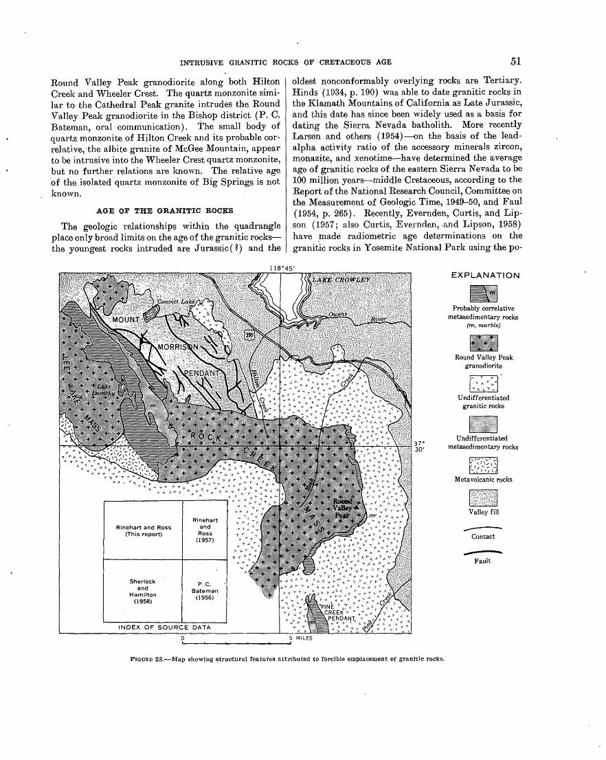
INTRUSIVE GRANITIC ROCKS OF CRETACEOUS AGE 51
Round Valley Peak granodiorite. along both Hilton Creek and Wheeler Crest. The quartz monzonite similar to the Cathedral Peak granite intrudes the Round Valley Peak granodiorite in the Bishop district (P. C~ Bateman, 01.-al communication). The small body of quartz monzonite of Hjlton Creek and its probable correlative, ·the albite granite of McGee Mountain, appear to be intrusive into the Wheeler Crest quartz mon~onite, but no ·further relations are kno,vn. The relative age of the isolated quartz monzonite of Big Springs is not known.
AGE OF THE GRANITIC ROCKS
The geologic relationships within the quadrangle place only broad limits on the age of the granitic rocksthe youngest rocks intruded are Jurassic(~) and the
v " , ., .... \1 ~ ~
.... ., :" ".,t' ..... .., ( .,.,~, < ..J ..I 1\ ,_ '\ > l.oo
.., ~ \1' '\1
\"', "., f"" f"
l..o.> ..... "-, ,J ~ ~ ~ .,
Rinehart and Ross (This report)
Sherlock and
Hamilton (1958)
Rinehart and Ross
(1957)
P. C. Bateman
(1956)
INDEX OF SOURCE DATA
.0
oldest n:onconformably overlying rocks are Tertiary. Hinds (1934, p. 190) was able to date granitic rocks in the Klamath Mountains of California as Late Jurassic, and this date has since been widely used as a basis for dating the Sierra Nevada batholith. More· recently Larsen and others (1954)~on the basis of the leadalpha activity ratio of the accessory minerals zircon, monazite, and xenotime-have determined the average age of granitic rocks of the eastern Sierra Nevada to be 100 million years-middle Cretaceous, according to the Report of the National Research Council, Committee on the Measurement of Geol~gic Time, 1949-50, and Faul {1954, p. 265). Recently, Evernden, Curtis, and Lipson (1957; also Curtis, Evernden, -and Lipson, 1958) have _made radiometric age determinations on the granitic rocks in Yosemite National Park using the po-
5 MILES
EXPLANATION
Ill Probably correlative
metasedimentary rocks (m, marble)
Round Valley Peak granodiorite
Undifferentiated granitic rocks ..
Undifferentiated metasedimentary rocks
Metavolcanic rocks
M Valley fill
------Contact
Fault
~-~--~--------~--~
FIGURE 23.-l\fap showing structural features attributed to forcible emplacement of grani•tic rocks.

52 GEOLOGY AND MINERAL DEPOSITS, MOUNT .MORRISON QUADRANGLE, CALIF.
tassium-argon method. The relative ages within the series, as determined by this method, corroborate the field evidence and include a range in age· of 82.4 to 95.3 million y~ars. This also places the rocks approx~mately as middle Cretaceous .in the geologic time scale, and on this basis the granitic rocks in the Mount . Morrison quadrangle are provisionally assigned to the Cretaceous.
VOLCANIC ROCKS OF CENOZOIC AGE
Volcanic rocks, divisible into nine mapped units, are e·xposed over an area of about 50 square miles in the northwestern quarter of the quadrangle and include a few small remnants in the Sierra Nevada near the front of the range. The rocks range in composition from basalt to rhyolite, and in age from Tertiary to Recent( n. In general the mafic and. intermediate rocks occur as flows and the felsic varieties as domes and stubby coulees. In the following paragraphs the discussion is divided into three parts- ( 1) field descriptions, (2) petrology, and (3) age-in order to consolidate similar kinds of data from each volcanic unit so that comparisons can be more easily drawn.
FIELD DESC·RIPTION
VOLCANIC ROCKS OF THE M'AMMOTH EMBAYMENT
The term "Mammoth Embayment" was coined by Mayo (1934a) for the large L-shaped reentrant in the eastern front of the Sierra Nevada, the base of which extends almost due west from McGee Mountain to Old Mammoth; the upright leg trends slightly west of north and extends into the Devils Postpile quadrangle adj acent on the west. Most of the volcanic rocl,i:s in the quadrangle are within this embayment. The un_its are described in the general order of decreasing age with the exception of pumice, the youngest volcanic unit. Pumice is described first because of repeated reference to it iil the descriptions of the other volcanic units ..
PUMICE
The ·area underlain by the volcanic rocks· is covered . by an unconsolidated pumice blanket which ranges in thickness from less than an inch to as much as several tens of feet and which apparently becomes progressively
. thicker to the north. The blanket consists of subangular light-gray pumice fragments less than an inch in av·erage diameter intermixed with fine-grained dusty material composed partly of mechanically distintegrated pumice and partly of volcanic ash. Most of the pumice in the Mammoth Embayment is of Quaternary age, but at a few localities pumice of Tertiary age may be intermixed. The principal source was undoubtedly the series . of vents that lie just west of the quadrangle boundary in the Devils Postpile quadrangle. These vents are
alined with, and form a southward continuation of, the Mono Craters (Mayo, Conant, and Chelikowsky, 1936). Some of the material is probably as young as Recent.
The pumice shown on the geologic map (pl. 1) lies in rather broad flat areas, which are generally topographic lows, in the north western part of the quadrangle. Because of its topographic position, the pumice undoubtedly c9ntains some alluvium. The alluviated areas are ~o poorly defined, however, that they were not mapped separately. Although not mapped elsewhere. in the vol-· canic terrane, pumice is widely distributed and obscures a considerable proportion of most of the volcanic map units, but it was generally 1-lot practicable to distinguish pumice from bedrock on the map. The pumice mantle typically extends over all but the crests of the ridges and the steepest parts of escarpments and stream canyons in the embayment.
ANDESITE
Andesite (pl. 1) covers an area of 2112 square miles and is exposed at three general localities: (1) a narrow belt extending northward from the Mammoth Ranger Station for about 3 miles and a small outlier along Mammoth Creek southwest of Camp High Sierra, (2) a broad area of discontinuous exposures paralleling Dry Creek from the wes~ boundary of the quadra.ngle to the base qf Lookout Mountain, (3) small exposures in the extreme northwest,corner of the quadrangle. One specimen from: the narrow belt extending northward from the Mammoth Ranger Station was analyzed chemically {table 9, No .. M-665a) and proved to be a trachyandesite. "The alkalic nature of the rock is not reflected in the determinable mineralogy ; and as some rocks of unknown age that differ slightly in composition are included under this heading, the. less restrictive term "andesite" is preferred. The greatest exposed thickness is 400 feet in an escarpment a quarter of a mile north of the Mammoth Ranger Station, and the base is not exposed .. Individual flows within the section were not recognized, but it seems unlikely that the entire thickness represents a single flow.
The interrelationship of the .andesite at the. three isolated loc.alities was not established in the field, although rocks from all three masses are· indistinguishable in appearance. Chemical evidence, however, suggests that the andesite exposed discontinuously along Dry Creek and the andesite.exp·osed in the belt north of the Mammoth Ranger Station are correlative. The andesite exposed in the northwest corner of the. quadrangle is the south tip of a large mass .that extends northwestward for several miles; chemical evidence ( p. 60-62) suggests that this andesite. is probably not correlative with the andesite exposed at the two other localities.
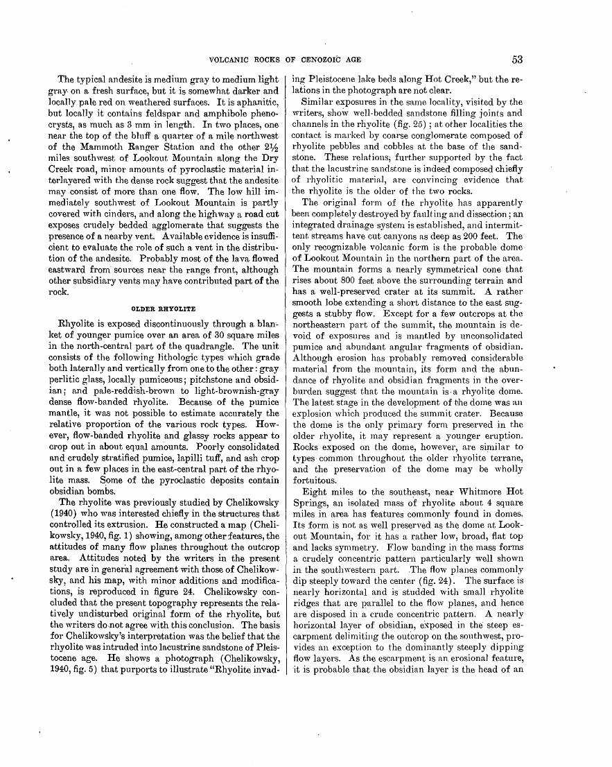
VOLCANIC ROCKS OF CENOZOIC AGE 53
The typical andesite is medium gray to medium light gray. on a fresh surface, but it is somewhat darker and locally pale red on weathered surfac.es. It is aphanitic, but locally it contains feldspar and amphibole phenocrysts, as much as 3 mm in length. In two places, one nen.r the top of the bluff a quarter of a mile northwest of the Mammoth Ra.nger Station and the other 21;2 miles southwest of Lookout Mountain along the Dry Creek road, minor amounts of pyroclastic material interlayered with t.he dense rock suggest that the andesite may consist of more than one flow. The low hill immediately southwest of Lookout Mountain is partly covered with cinders, and along the highway a road cut exposes crudely bedded agglomerate that suggests the presence of a nearby vent. Available evidence is insufficient to evaluate the role of such a vent in the distribution of the andesite. Probably most of the lava flowed eastward from· sources near the range front, although other subsidiary vents may have contributed part of the rock.
OLDER RHYOLITE
Rhyolite is exposed discontinuously through a blan~ ket of younger pumice over an area of 30 square miles in the north-central part of the quadrangle. The unit consists of the following lithologic types which grade both laterally and vertically.from one to the other: gray perlitic glass, locally pumiceous; pitchstone and obsidian; and pale-redd·ish-brown to light-brownish-gray dense flow-banded rhyolite. Because of the pumice mantle, it was not possible to estimate accurately the relative proportion of the various rock types. However, flow-banded rhyolite and glassy rocks appear to crop out in about equal am.ounts. Poorly consolidated and crudely stratified pumice, lapilli tuff, and ash crop out in a few places in the east-central part of the rhyolite mass. s.ome of the pyroclastic deposits contain obsidian bombs.
The rhyolite was previously studied by Chelikowsky (1940) who was interested chiefly in the structures that controlled its extrusion. He constructed a map ( Chelikowsky, 1940, .fig. 1) showing, among other features, the a.ttitudes of many flow planes throughout the outcrop area. Attitudes noted by the writers in the present study are in general agreement with those of Chelikowsky, and his map, with minor additions and modifications, is reproduced in figure 24. Chelikowsky concluded that the present topography represents the relatively undisturbed original· form of the rhyolite, but the writers do.not agree with this conclusion. The basis for Chelikowsky's interpretation was the belief tha.t the rhyolite was intruded into lacustrine sandstone of Pleistocene age. l-Ie shows a photograph ( Chelikowsky, 1940, fig. 5) that purports to illustrate "Rhyolite invad-
ing Pleistocene lake beds along Hot Creek," but therelations in the photograph are not clear.
Similar exposures in the same locality, visited by the writers, show well-bedded sandstone filling joints and channels in the rhyolite (fig. 25); at other localities the contact is marked by coarse conglomerate composed of rhyolite pebbles and cobbles at the base of the sandstone. These relations; further supported by the fact that the lacustrine sandstone is indeed composed chiefly of rhyolitic ma.teria.l, are convincing evidence that the rhyolite is the older of the two rocks.
The original form of the rhyolite has apparently been completely destroyed by faulting and dissection; an integrated drainage system is established, and intermittent streams have cut canyons as deep as 200 feet. The only recognizable volcanic form is the probable dome of Lookout Mountain in the northern part of the area. The mountain forms a nearly symmetrical cone that rises about 800 feet above the surrounding terrain and has a well-preserved crater at its summit. A rather smooth lobe extending a short distance to the east suggests a stubby flow. Except for a few outcrops at the northeastern part of the summit, the mountain is devoid of exposures and is mantled by unconsolidated pumice and abundant angular fragments of obsidian. Although erosion has probably removed considerable material from the mountain, its form and the abundance of rhyolite and obsidian fragments in the overburden suggest that the mountain is· a rhyolite dome. The latest stage in the development of H1e dome was an explosion which produced the summit crater. Because the dome is the only primary form preserved in the older rhyolite, it may represent a younger eruption. Rocks exposed on the dome, however, are si:~nilar to types common throughout the older rhyolite terrane, and the preservation of the dome may be wholly fortuitous.
Eight miles to the south~ast, near 'Vhitmore Hot Springs, an isolated mass of rhyolite about 4 square miles in area has features commonly found in domes. Its form is not as well preserved as the dome at Lookout Mountain, for it has a rather low, broad, flat top and lacks symmetry. Flow banding in the mass forms a crud.ely concentric pattern particularly well shown in the southwestern part. .The flow planes commonly dip steeply toward the center (fig. 24). The surface is nearly horizontal and is studded with small rhyolite ridges that are parallel to the flow planes, and hence are disposed in a crude concentric pattern. A nearly horizontal layer of obsidian, e~posed in the steep escarpment delimiting the outcrop on the southwest, provides an exception to the dominantly steeply dipping flow layers. As the escarpment is an erosional feature, it is probable that the obsidian layer is the head of an
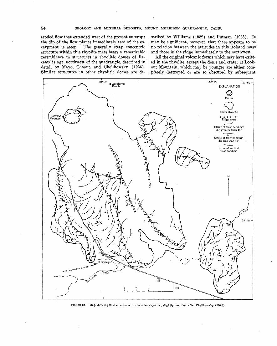
54 GEOLOGY AND MINERAL DEPOSITS, MOUNT MORRISON QUADRANGLE, CALIF.
eroded flow that extended west of the present outcrop ; the dip of the flow planes immediately east of the escarpment is steep. The generally steep concentric structure within this rhyolite mass bears a remarkable resemblance to structures in rhyolitic domes of Recent ( ? ) age, northwest of the quadrangle, described in. detail by Mayo, Conant, and Chelikowsky ( 1936). Similar structures in other rhyolitic domes are de-
cJ Lookout Mountain
118°55' • Arcularius
Ranch
scribed by Williams (1932) and Putman (1938). It may be significant, however, that there appears to be no relation between the attitudes in this isolated mass and those in the ridge immediately to the northwest.
All the original volcanic forms which may have existed in the rhyolite, except the dome and crater at Lookout Mountain, which may be younger are either completely destroyed or are so obscured by subsequent
118°50' 37°45'
EXPLANATION
0 Crater
c::;) Older rhyolite
oo"'C5"0~ Ridge crest
__,.-/ Strike of.flow banding;
dip greater than 45 o
-r-Strike of flow banding;
dip less than 45° __,__ Strike of vertical
flow banding
N
FIGURE 24.-Map showing tl.ow structures in the older rhyolite; slightly modified after Chelikowsky (1940).
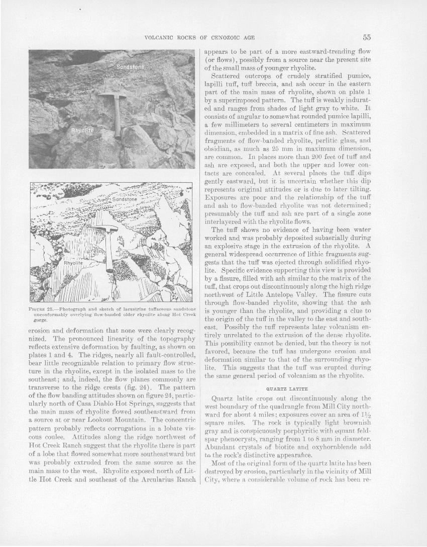
VOLCANIC ROCKS OF CENOZOIC AGE 55
FIGURE 25.-Photogruph and sketch of lacustrine tuffaceous sandstone unconformably overlying flow-banded older rhyolite along Hot Creek g()rge.
erosion and deformation that none were clearly recognized. The pronounced linearity of the topography reflects extensive deformation by faulting, as shown on plates 1 and 4. The ridges, nearly all fault-controlled, bear little recognizable relation to primary flow structure in the rhyolite, except in the isolated mass to the southeast; and, indeed, the flow planes commonly are transverse to the ridge crests (fig. 24). The pattern of the flow banding attitudes shown on figure 24, particularly north of Casa Diablo Hot Springs, suggests that the main mass of rhyolite flowed southeastward from a source at or near Lookout Mountain. The concentric pattern probably reflects corrugations in a lobate viscous coulee. Attitudes along the ridge northwest of Hot Creek Ranch suggest that the rhyolite there is part of a lobe that flowed somewhat more southeastward but was probably extruded from the same source as the main mass to the west. Rhyolite exposed north of Little Hot Creek and southeast of the Arcularius Ranch
appears to be part of a more eastward-trending flow (or flows), possibly from a source near the present site of the small mass of younger rhyolite.
Scattered outcrops of crudely stratified pumice, lapilli tuff, tuff breccia, and ash occur in the eastern part of the main mass of rhyolite, shown on plate 1 by a superimposed pattern. The tuff is weakly indurated and ranges from shades of light gray to white. It consists of angular to somewhat rounded pumice lapilli, a few millimeters to several centimeters in maximum dimension, embedded in a matrix of fine ash. Scattered fragments of flow-banded rhyolite, perlitic glass, and obsidian, as much as 25 mm in maximum dimension, are common. In places more than 200 feet of tuff and ash are exposed, and both the upper and lower contacts are concealed. At several places the tuff dips gently eastward, but it is uncertain whether this dip represents original attitudes or is due to later tilting. Exposures are poor and the relationship of the tuff and ash to flow-banded rhyolite was not determined; presumably the tuff and ash are part of a single zone interlayered with the rhyolite flows.
The tuff shows no evidence of having been water worked and was probably deposited subaerially during an explosive stage in the extrusion of the rhyolite. A general widespread occurrence of lithic fragments suggests that the tuff was ejected through solidified rhyolite. Specific ev-idence supporting this view is provided by a fissure, filled with ash similar to the matrix of the tuff, that crops out discontinuously along the high ridge northwest of Little Antelope Valley. The fissure cuts through flow-banded rhyolite, showing that the ash is younger than the rhyolite, and providing a clue to the origin of the tuff in the valley to the east and southeast. Possibly the tuff represents later volcanism entirely unrelated to the extrusion of the dense rhyolite. This possibility cannot be denied, but the theory is not favored, because the tuff has undergone erosion and deformation similar to that of the surrounding rhyolite. This suggests that the tuff was erupted during the same general period of volcanism as the rhyolite.
QUARTZ LATITE
Quartz latite crops out discontinuously along the west boundary of the quadrangle from Mill City northward for about 4 miles; exposures cover an area of 11/2 square miles. The rock is typically light brownish gray and is conspicuously porphyritic with equant feldspar phenocrysts, ranging from 1 to 8 mm in diameter. Abundant crystals of biotite and oxyhornblende add to the rock's distinctive appearance.
Most of the original form of the quartz latite has been destroyed by erosion, particularly in the vicinity of Mill City, where a considerable Yolume of rock has been re-
56 GEOLOGY AND MINERAL DEPOSITS, MOUNT MORRISON QUADRANGLE, CALIF.
moved by glaciation. The northernmost exposure, however, has been substantially less eroded, probably because of its protected positon between glaciated valleys; it is in the form of a symmetrical dome elongated northwestward. The northwestern half of the dome is in the Devils Postpile quadrangle adjacent on the west. No ' internal structure was found as most of the dome is covered by pumice and the rock is structureless in all outcrops visited. Exposures near Camp High Sierra and Mill City are along spurs which extend into the quadrangle from Mammoth Mountain adjacent on the west. The rocks of Mammoth Mountain were not studied in detail, but the rocks exposed in the spurs are similar in appearance and_ composition to those in the elongate dome to the north and are probably genetically related.
YOUNGER RHYOLITE
Rhyolite, clearly younger and distinctly different in character than the older rhyolite, covers a total area of about 51h square miles. It occurs at 3 widely separated localities: ( 1) a large mass that extends northward from Mammoth Lakes to Dry Creek; ( 2) a smaller mass, little more than a square mile in extent, exposed 1112 miles southeast of the Arcularius Ranch; (3) a small tufa-capped hill, half a mile north of "Whitmore Hot Springs.
The rhyolite is generally light to medium gray, structureless, and remarkably homogeneous. It is distinguished from the older rhyolite by : ( 1) lighter color; (.2) lower specific gravity (1.7 compared to 2.2 in the older rhyolite) ; and (3) a sprinkling of conspicuous 1- to 2-mm euhedral crystals of biotite and hornblende and moderately abundant feldspar phenocrysts, 1 to 5 mm across.
The large mass north of Mammoth Lakes consists of two small domes at the south end, a third dome along the west side, and a northward-sloping coulee that extends the full length of the mass. A thick pumice mantle blankets the rhyolite and obscures nearly all but the gross physical features. The form is generally well preserved and has not been greatly modified by either faulting or erosion. The surface of the coulee is slightly convex, has an average slope northward of about 4°, and is generally steep sided, standing about 250 feet above the adjacent land surface. The domes are circular in plan with diameters of about half a mile. Because they are steep sided and rise above the surface of the coulee as much as 400 feet, they probably rose after the coulee was formed. It is possible that the pumice mantle is in part genetically related to the extrusion of the rhyolite, but craters are not present and- no other evidence of related pyroclastic activity was found.
Although the form of the rhyolite has been modified little by erosion, some material has been removed from
both the southern and northern ends of the mass. Glacial till flanks the rhyolite on the northwest and south and suggest.s that glaciers ma.y have cut aw·ay and steepened the escarpments at these localities. There is no evidence that glaciers overrode the mass. The small outlier, which caps a low andesite. hill south of Lookout :Mountain, "·as undoubtedly origi:J;1al1y contiguous · with the main body to the west. This suggests that considerable intervel{ing; materia 1 was removed probably as a result of stream erosion.
The mass of younger rhyolite so11theast of the Arcularius Ranch is exposed over an area of a little more than a square mile a.nd was apparently extruded through older rhyolite. A circular dome, about half a mile in diameter, occurs at the east end of the mass, and the west end is marked by what appears to be the south rim of a breached crater. The dome stands about 350 feet above the land surface adjacent on the south and west and is separated from the breached crater to the west by a gorge 2.50 feet deep. The remaining segment of the crater rim stands less than 100 feet above the land surface to the south but more than 250 feet above the partly enclosed crater floor to the north. The long tongue projecting into the valley to the north is probably a flow, of which the small outlier to the northeast is probably a part. .
Lithologically the rhyolite in this area is identical to rocks composing the large mass, except for a small pumice-mantled outcrop of tuff breccia that contains rhyolite fragments as much as 18 inches across. The presence of the tuff breccia and of the breached crater suggests that strong pyroclastic activity accompanied the extrusion of the rhyolite in this area;
The rhyolite in the tufa-capped hill north of Whitmore Hot Springs is so poorly exposed and small in extent that little can be deduced concerning its origin. Aithough lithologically identical to rocks of the other masses, the considerable intervening distances make it imp:r:obable that this mass was ever a.really connected with them. The original areal extent of this rhyolite is unknown, but it seems likely that it erupted from a local source. It was later covered by Pleistocene Long Valley -Lake and a c~msiderable additional volume may lie beneath the lake beds.
BISHOP TUFF OF GILBERT (1938)
A small amount of a crystal-rich facies of the rhyolitic Bishop tuff crops out ·in a low hill about a mile west of the Arcularius Ranch along the north boundary of the quadrangle. The rock is ~ight pinkish gray, structureless, and rich in water-clear crystals of feldspar and quartz that are in a microgranular and glassy matrix. It contains many accidental fragments of basalt and bath plu1tonic and metamorphic rocks. In ap-

VOLC~C ROCKS·OF CENOZOIC AGE 57
pearance the rock is much different than correlative tuff exposed north and east of the quadrangle, largely because it contains abundant crystals and lacks conspicuous salmon-c<;>lored pumice fragments (see Gilbert, 1938; R~nehart and Ross, 1957). Nevertheless, correlation can be proved by tracing the tuff northward towa.rd'the Mono Craters, where it grades into the typical coarsely fragmental pumiceous rock mapped as Bishop tuff by Gilbert ( 1938) .
BASALT
Basalt flows are discontinuously exposed over a total area of about 5 square miles and occur at two widely separated localities: ( 1) from a mile east of Mammoth Lakes eastward to Hot Creek Ranch, and (2) along the north edge of the quadrangle eastward from Deadman Creek for 9 miles. The maxim urn exposed thickness in both flows is about 100 feet; and although the lower contact was not seen, the total thickness is probably not much greater. The flows are modified but little by erosion and owe their discontinuous outcrop pattern chiefly to partial burial by pumice near Deadman Creek and by glacial till near Mammoth Creek. Except for channels cut by both Mammoth and Deadman Creeks, both flows are practically undissected. The lava in both flows slopes gently eastward and was probably extruded from vents a few miles west of the quadrangle boundary near the Sierra Nevada front. Beyond their westernmost exposures both flows are buried and cannot be traced to their sources.
. Both flo'YS have surfaces that are fresh, typically scoriaceous,. and locally ropy. Rocks from both the northern and southern flows are lithologically identical and are probably from the same magma. The rock is typically vesicular and has a distinctive porphyritic texture with equant felrlspa.r phenocrysts, as large as 2 em across. The vesicles are commonly li11ed with opal and, in the south flow near the h0t springs, also contain aragonite, some of which forms acicular prisms as long as 2 em. Inclusions are generally uncommon, but some small fragmenf:-8 of older rhyolite and· granitic rocks were found in a few places.
Two small outcrops o{ basalt and associated cinders were found on the north fl.'ank of the quartz latite dome that is intersected by the 'west boundary of the quadrangle, 11h miles not·thwest of the St. Joseph Chapel. Although exposures are poor, there is little doubt that the basalt was e~truded through the flank of the quartz latite dome. ·
OLIVINE-BEARING QUARTZ LATITE
A flow of olivine-hearing quartz latite covers about 1 square mile in the ·northwestern part of the quadrangle and appears to have flowed onto the surface of the
basalt flow, which crops out nearby. The rock consists of abundant white feldspar phenocrysts, 2 to 3 mm in diameter, in a dark-gray aphanitic or glassy matrix, giving the rock a marked resemblance. to. the basalt. Accidental fragments include granitic and metamorphic rocks, basalt, and andesite. The matrix. commonly has a pitchy luster which generally distinguishes the rock from ·the basalt. The rock is dominantly structureless, but indistinct flow banding was detected locally. A· small gully on the southeast side marks the contact with older andesite, which is slightly higher topographically. The northern limit is a lobate<escarpment about 50 feet high that appears to be the front of the flow. The surface of the flow slopes gently to the northeast, suggesting a source to the southwest where it passes beneath the pumice blanket. Although the source was not identified, several Recent volcanic domes lie less than a mile west of the quadrangle boundary and may mark vents from which the olivine-bearing quartz latite erupted.
VOLCANIC ROCKS OF THE SIERRA. NEVADA.
Remnants of volcanic flows occur near the range front at three lqcalities in the Sierra Nevada (on pl. 1). Andesite caps parts of both McGee ~1ountain and the ridge east of Lake Mary, and a small remnant of a quartz latite flow is perched. on a ridge about a mile northwest ·of Convict Lake. The rocks are exposed at altitudes ranging from 9,500 feet to slightly more than 10,000 feet and cover a total area of less than a square mile.
The andesite· on McGee Mountain is typically p~le reddish brown and extremely fine grained; it contains sparse 1-lnm feldspar phenocrysts. Exposures consist mostly of rubbly, somewhat scoriaceous, ropy material in which well-formed bombs are common. The andesite east of Lake Mary is med!um gray to medium dark gray and. contains abundant crystals of olivine 1- to 2-mm long in an aphanitic matrix. The rock is typically dense and nonporous, but vesicular material was found locally. The quartz latite( n northwest of Convict Lake is medium light gray, dense, structureless, and contains scattered tiny crystals of biotite and hornblende in an aphanitic matrix.
All the flows were extruded on a surface of gentle to moderate relie.f probably prior to the. uplift which elevated the range to its present height. The nature of the topography beforethe volcanism is illustrated by a wellpreserved remnant of the old surface on top of McGee Mountain (figs. 26 and 27·). As most of the flows have been stripped, little evidence of the sources remains, but abundant bombs and scoriaceous brick-red ao-o-lomeratic bb
m,aterial on McGee Mountain indicates a nearby source. The andesite. east of Lake ~1ary is probably correlative with remnants of a flow at a comparable altitude along
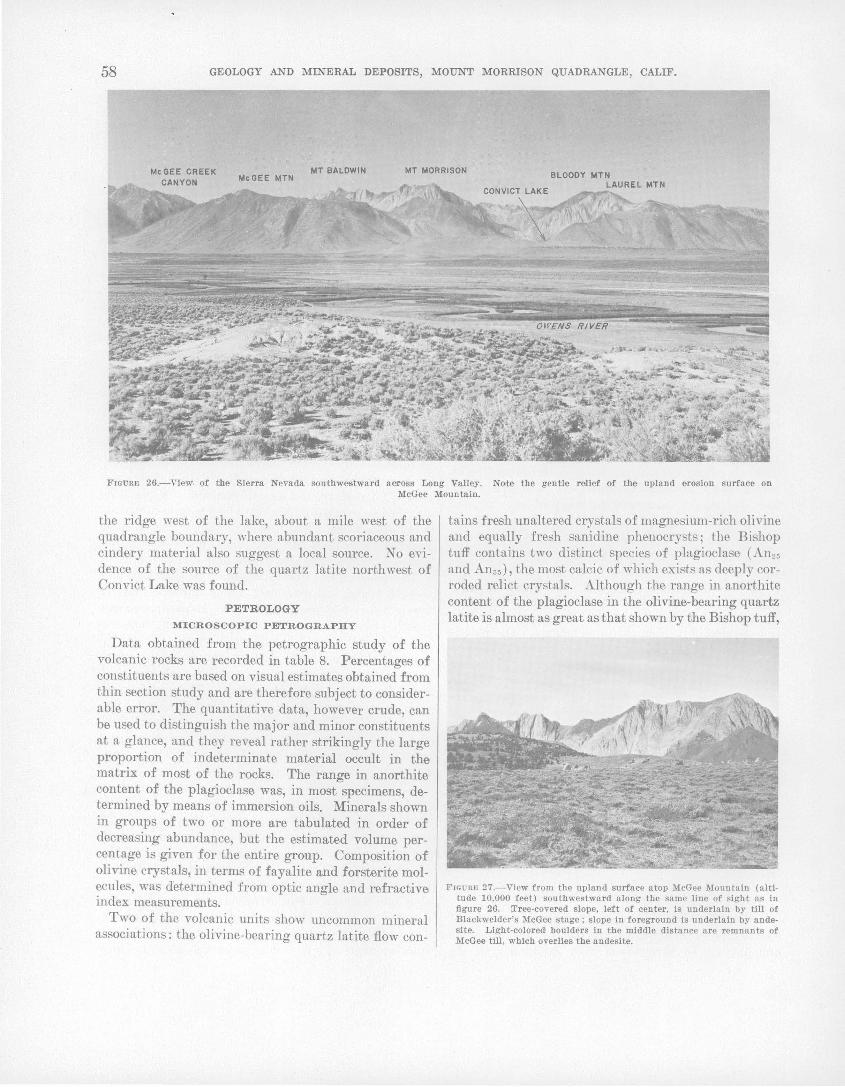
58 GEOLOGY AND MINERAL DEPOSITS, MOUNT MORRISON QUADRANGLE, CALIF.
MT BALDWIN MT MORRISON McGEE MTN
FIGURE 26.-VieWI of the Sierra Nevada southwestward across Long Valley. Note the gentle relief of the upland erosion surface on McGee Mountain.
the ridge ''est of the lake, about a mile west of the quadrangle boundary, where abundant scoriaceous and cindery material also suggest a local source. No evidence of the source of the quartz latite northwest of Convict Lake was found.
PETROLOGY
MICROSCOPIC PETROGRAPHY
Data obtained from the petrographic study of the volcanic rocks are recorded in table 8. Percentages of constituents are based on visual estimates obtained from thin section study and are therefore subject to considerable error. The quantitative data, however crude, can be used to distinguish the major and minor constituents at a glance, and they reveal rather strikingly the large proportion of indeterminate material occult in the matrix of most of the rocks. The range in anorthite content of the plagioclase was, in most specimens, determined by means of immersion oils. Minerals shown in groups of two or more are tabulated in order of decreasing abundance, but the estimated volume percentage is given for the entire group. Composition of olivine crystals, in terms of fayalite and forsterite molecules, was d·eterrnined from optic angle and refractive index measurements.
Two of the volcanic units show lmcommon mineral associations: the olivine-bearing quartz latite flow con-
tains fresh unaltered crystals of magnesium-rich olivine and equally fresh sanidine phenocrysts; the Bishop tuff contains two distinct species of plagioclase (An25
and Anss ), the most calcic of which exists as deeply corroded relict crystals. Although the range in anorthite content of the plagioclase in the olivine-bearing quartz latite is almost as great as that shown by the Bishop tuff,
FIGU UE 27.- V!ew from the upland surface atop McGee Mountain (altitude 10,000 feet) southwestward along the same line of sight as In figure 26. :rree-covered slope, left of center, Is underlain by till of Blackwelder's McGee stage; slope In foreground is underlain by andesite. Light-colored boulders in the middle distance a re remnants of McGee till, which overlies the andesite.
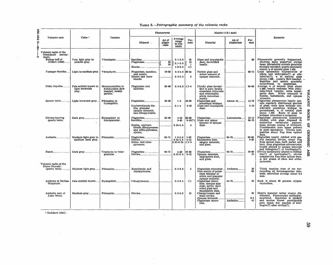
0:0 OD
f ~ c.o
t Volcanic unit Color 1 Texture
TABLE B.-Petrographic summary of the volcanic rocks
Mineral
Phenocrysts
An of plagioclase
Average range in size (mm)
Percent
Matrix ( <O.l mm)
Material An of
plagioclase
I Volcanic rocks of the Mammoth embay·
at ment: Bishop tuff of I Very light gray to
Gilbert (1938).____ pinkish gray. Vitroclastic. __ --------' Sanidine. -------------~----------~ 0. 1-5.0 I 25 Plagioclase. ___________ { ~ } 0_1_
5_0
{ 1~
Biotite ________________ ---------- 1. o-2. 0 <I
Younger rhyolite ... ! Light to medium gray -I Vitrophyric-----------1 Plagioclase, sanidine, and quartz.
Older rhyolite ...... ! Pale reddish brown to light brownish :rray.
Merocrystalline to holohyaline; flow banded; locally perlitic.
Quartz latite ....... l Light brownish gray .. ! Pilotaxiticto hyalopilitic.
Biotite and hornblende.
P).agioclase and sanidine.
Plagioclase ___________ _
Oxyhornblende bio-tite, granular opaque minerals, and clinopyroxene.
10--30
25-40
40-50
0. 2-5. 0 12o-35
0. 2-2.0 5
0. 2-0.8 I<I-5
1. 8 11o-20
0.1-4 5-10
Glass and impalpable 1----------------1 dust; devitrified locally.
Perlitic glass and minor amount of opaque minerals.
Chiefly glass devitrified in part; locally abundant tridymite and cristobalite; albite microlites . locally.
Plagioclase and . potassium feldspar.
Glass and impalpable dust.
About 10 ..... .
Olivine-bearing quartz latite.
Dark graY-------------1 Hyalopilitic to intergranular.
Plagioclase ___________ _J 25-50
Sanidine. -------------
Biotite, o~horn· blende, clinopyroxene and ortho-pyroxene, olivine.
5-10 12o-30 I Plagioclase ___________ _! Labradorite ... 5-10 5-10(?) Glass and minor
amount of opaque 0. 05-0. 6 5 dust.
Andesite .. ----------1 Medium light gray to I Pilotaxitic ..•• ---------1 Pla~oclase ____________ l' 65-75,I.o-5.0 ,1-20 medium dark gray. Olivme __ . ______________ ---------- 0.05-1.0 5-15
Ortho- and clino- 0. 01-{). 05 < 1-5 pyroxene.
Basalt_ ____________ .! Dark graY-------------1 Trachytic to inter-granular.
Plagioclase ___________ , 65-751 5-20 11o-20 Olivine ________________ ---------- 0. 01-{). 3 5-15
Volcanic rocks of the Sierra Nevada:
Quartz latite ....... l Medium light gray .... ! Pilotaxitic _____________ l Hornblende and clinopyroxene.
Andesite of McGee I Pale reddish brown ... ! Hyalopilitic ___________ l Clinopyroxene ________ , _________ _ Mountain.
Andesite east of I Medium gray ..•...... l PilotaxitiC------------1 Olivine ________________ , _________ _ Lake Mary.
1 Goddard (1951).
0. 2-3.0
0. 5-1.5 <1
0. 2-2.0 15
Plagioclase ... ________ _! 6o-70 _________ _ Impalpable dust,
opague minerals, and glass.
Pla:tioclase ___________ _l 65-70 ... ______ _ Opaque minerals,
impalpable dust, and glass.
Plagioclase microlites .. l Andesine _____ _ Fine matrix of potas-
sium feldspar or albite and granular opaque material.
Plagioclase micro- I 55-70 _________ _ lites, opaque min-erals; partly devi-trifed glass and impalpable dust.
Clinopyroxene and some olivine.
Opaque minerals _____ -~----------------Plagioclase micro- Andesine _____ _
lites.
Percent
60
6o-75
95-99
15-70
5-70
1o-15 6o-70
6o-80 5-20
50-60 15
30 65
99
35
3-5 45
Remarks
Phenocrysts generally fragmented, showing some preserved crystal faces; labradorite crystals generally strongly corroded; quartz extremely scarce; n of natural glass 1.495.
Local spherulitic intergrowths of albite and tridymittc{?) or crtstobalite(?); n of natural glass about.l.500.- Locally .flow-banded. Sanidine and quartz generally subordinate to plagioclase.
Average n of natural glass about 1.500; locally vesicular with trldymite-lined vesicles; some impalpable dust. Minor amounts of biotite, hornblende, and opaque minerals.
Plagioclase phenocrysts locally contain regularly distributed patches of glass; stain tests indicate considerable potassium feldspar in groundmass; n of natural glass about 1.500. Ratio of glass to feldspar microlites is reciprocal.
Plagioclase phenocrysts commonly riddled with glass disposed in somewhat vermicular pattern; some reverse zoning of feldspars. Considerable pore space present in most specimens. Olivine com-. position about Fa2o from optical data.
Plagioclase locally riddled with matrix material; olivine about Faso from optical data, both earlier and later than plagioclase phenocrysts; locally altered to opaque minerals and iddingsite(?) or bowlingite(?).
Olivine moderately altered to iddingsite('!) or bowlingite(?); olivine composition Fa2o from optical data. A few grains of clino- and orthopyroxene.
Thick reaction rims of ore surrounding all ferromagnec;ian minerals; microlites average about 0.2 mm.
Rock is about 80 percent cryptocrystalline.
Matrix material rather evenly distributed. Phenocrysts subhedral, unaltered. Specimen is cindery and section shows considerable pore space; few patches of bowlingite(?) after olivine(?).
< 0 t'4
~ ~ 0
~ 0 "=!
c l':2
~ ~
~
~
$
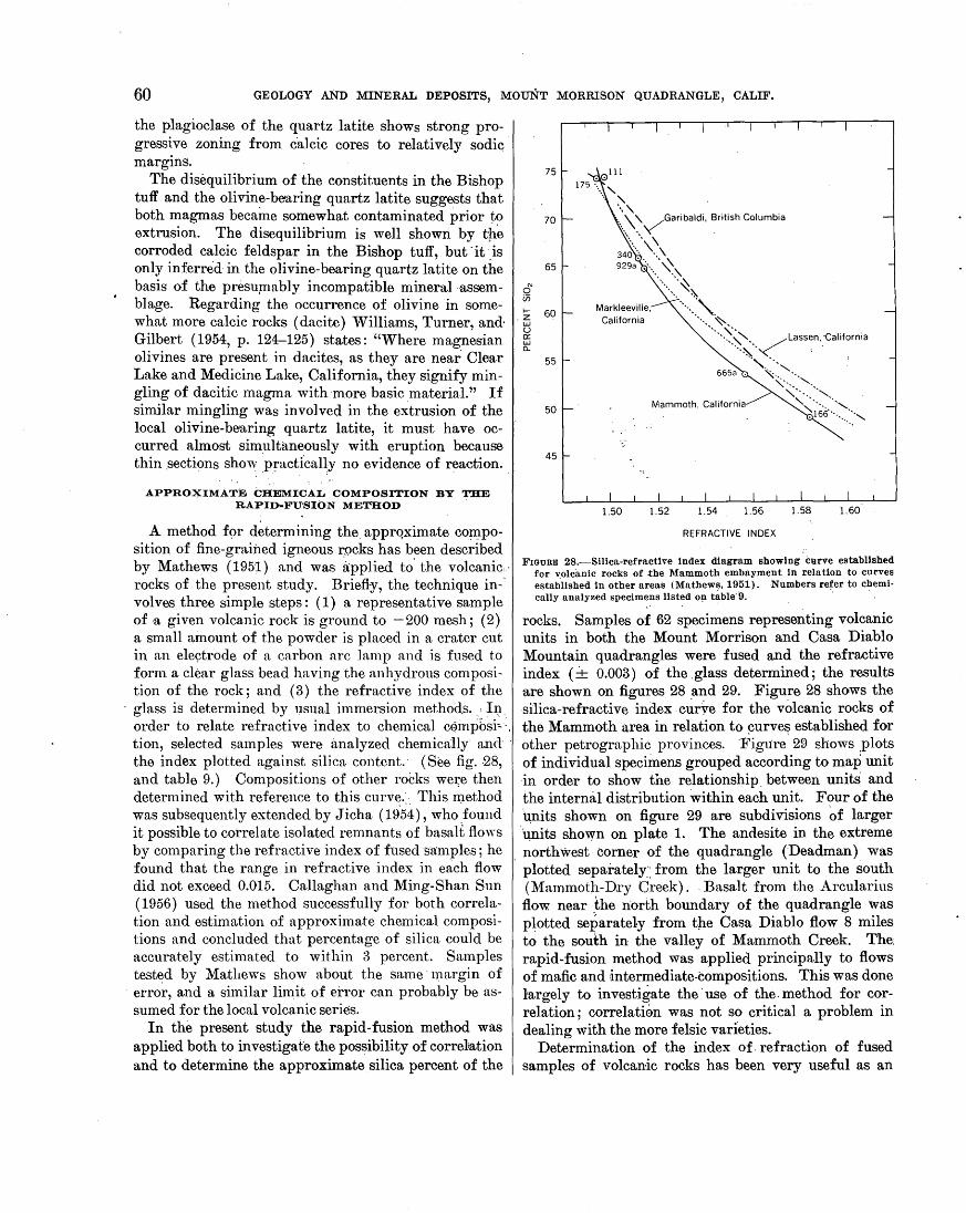
60 GEOLOGY AND MINERAL DEPOSITS, MOuNT MORRISON QUADRANGLE, CALIF.
the plagioclase of the quartz latite shows strong progressive zoning from c·alcic cores to relatively sodic margins.
The disequilibrium of the constituents in the Bishop tuff and the olivine-be'aring quart-z latite suggests that both magmas became somewhat contaminated prior to extrusion. The disequilibrium is well shown by tpe corroded calcic feldspar in the Bishop tuff, but 'it )s only inferred in the olivine-bearing quartz latite on the basis of the presu,mably incompatible mineral -assemblage. Regarding the occurrence of olivine in somewhat more calcic rocks (dacite) Williams, Turner, and· Gilbert (1954, p. 124-125) states: "Where magnesian olivines are present in dacites, as they are near Clear Lake and Medicine Lake, California, they signify mingling of dacitic magma with ·more basic material." If similar mingling was involved in the e~trusion of the local olivine-bearing quartz latite, it must have occurred almost simultaneously with eruption because thin .secti~ns show practi'cal~y no evidence of reaction.
APPROXIMATE CHEMICAL COMPOSITION BY THE RAPID-FUSION METHOD
A method f9r determining the_ apprqximate CO]JlpOsition of fine-grained igneous rycks has been described by Mathews (1951) and was ri:pplied to' the volcanic.· rocks of the present study. Briefl-y, the technique in-· volves three simple steps: ( 1) a representative sample of -a given volcanic rock is ground to - 200 mesh ; ( 2) a small ainount of the powder is placed in a crater cut in an ele9trode of a. carbon arc lamp and is fused to form a clear glass bead having the anhydrous com position of the rock; and ( 3) the refractive index of the glass is determined by usual immersion methods .. , I1~ . order to relate refractive index to chemical cf)mposi~-, tion, se.lected samples were ·analyzed chemica1ly an<l · the index plotted against silica content.· (See fig. -28, and table 9.) Compositions of other robks wm~e then determined with reference to this curve.· .. This method was subsequently extended by Jicha (19.54), who found it possible to correlate isolated remnants of basalt flows by comparing the refractive index of ft.lsed·s·a:mples; he found that the range in refractive index in each flow did not exceed 0.015. Callaghan and Ming-Shan Sun ( 1956) used the method successfully for both correlation and estimation of approximate chemical compositions and concluded that percentage of silica could be accurately estimated to within 3 percent. Samples tested by Matl1e\vs show about the same · margin of
· erro~, and a similar lin~it of error can probably be assumed for the local volcanic series.
In the present study the rapid-fusion method was applied both to investigate the possibility of correliation and to determine the approximate silica percent of the
0 en 1--
.Z w (.) 0:: w 0...
75
70
65
60
55
50
45
Markleeville, California
REFRACTIVE INDEX
FIGURE 28.-Silica-refractlve index diagram showing curve established for volcanic rocks of .the Mammoth embayment in r.elation to curves established in other areas (Mathews, 1951). Numbers refer to chemi-cally analyzed specimens listed o~ table.·9. ·. ·
,.
rocks. Samples of 62 specimens representing volcanic units in both the Mount Morrison and Casa Diablo Mountain quadrangles were fused and the refractive index (-+ 0.003) of the .glass determined; the results are shown on figures 28 _and 29. Figure 28 shows the -silica-refractive index cuiVe for the volcanic rocks of the Mammoth area in relation to ~urve~ established for other petrographic provinces. ·Figure 29 shows _plots of individual specimens grouped according to map unit 'in order to show tne relationship. between units and the intermil distribution within each unit. Four of the ~its shown on figure 29 are subdivisions ~f larger U,nits shown on plate 1. The andesite in the extreme
, northwest- corner of the quadrangle (Deadman)· was plotted separately:: from the larger unit to the south (:~1ammoth-D.ry Creek) .. Basalt from the Arcularius flow near _the north boundary of the quadrangle was p~otted separately from the Casa Diablo flow 8 miles to the south in the valley of Mammoth Creek. The: rapid-fusion method was applied principally to flows of mafic and 'intermediate-compositions. This was done largely to investigate the ·use of the. method for correlation; correlation was not so critical a problem in dealing with the more felsic varieties.
Determination of the index of. refraction of fused samples of volcanic rocks has been very useful as an
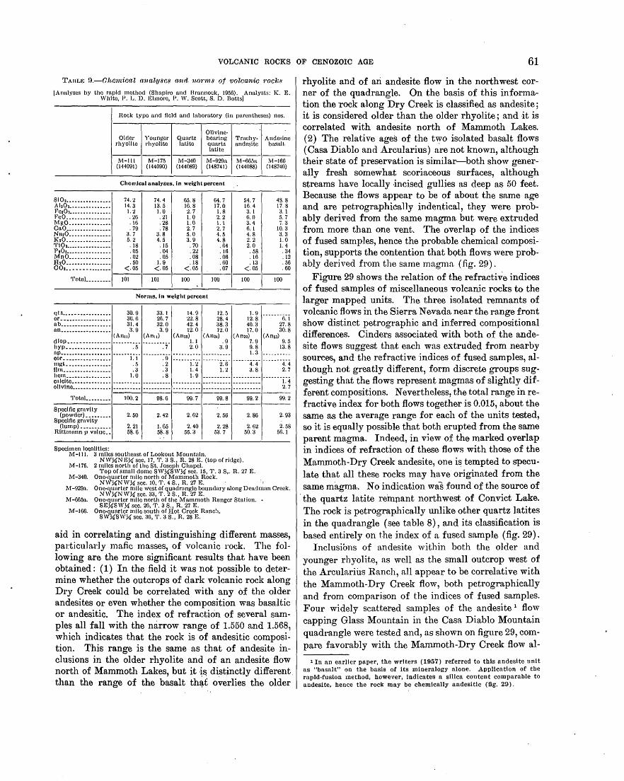
VOLCANIC ROCKS OF CENOZOIC AGE 61
~rAuu~ n.-Ohc·m'ioa.l a:na.l1J8C8 mul nonns of volcanic 1·ock8
[An11lyscs by tho rnpid met;hod (Shnpiro and Brannock, 1956). Analysts: K. E. White, P. L. D. Elmoro, P. W. Scott, S. D. Botts)
Hock typo nnd field and hlboratory (in pnrentheses) nos.
Olivine-Older Younger Qunrtz bearing Tmchy- Andesine
rhyolite rhyolite latito {IUartz andesite bnsalt latite ------------------
M-Ill M-175 M-340 M-929a M-665a M-166 (144091) (144090) (144089) (148741) (144088) (148740)
Chemical analyses, In weight percent
SiO~---------------- 74.2 74. 4 65.8 64.7 54. 7 4S. 8 Ah03.-------------- 14.3 13.5 Hi. 8 17.0 16.4 17.8 Fca03--------------- 1.2 1.0 2. 7 1.8 3. I :u l''eO ________________ . 26 . 21 1.0 2. 2 6. 0 5. 7
~~lg~::::::::: :::::: ,){) . 28 1.0 1.\ 3. 4 j, 3 . 79 . 78 2. 7 2. 7 6.1 10.3
Nn~o _______________ 3. 7 3. 8 5.0 4. 5 4. 8 3. 3 ]{20- --------------- 5. 2 4. 5 3. 9 4. 8 2. 2 1.0 Ti02---------------- . 18 .15 . 70 . 64 2. 0 1.4 P20~---------------- .05 . 04 . 22 .16 . 58 . 34 M'nO •• -----·-----·- . 02 . 05 . 08 .06 .16 .12 IhO •• ------·-----·- . 50 1.9 . 18 . 60 . 13 . 56 002 •• -- ---------·- <.05 <.05 <.05 .07 <.05 . 60 ------------------'i'otnJ. ________ 101 101 100 100 100 100
Norms, In weight percent
qt.z _____ -·--··----·- 30.9 33.1 14.9 12.5 1.9 or ••••• -----·-----·- 30. 6 26. 7 22. 8 28. 4 12. 8 6. 1 nb _________________ _
31.4 32.0 42.4 38.3 40.3 27.8 nn.................. 3. 9 3. 9 12.0 12.0 17.0 30.8
(An11) (An11) (An~2) (An24) (Amo) (An53) cllop ___________________________________ 1.1 .9 7.9 9.5 hyp________________ . 5 . 7 2. 0 3. 9 9. 8 13.8 llP--------·-·------- ---------- ---------- ---------- ---------- L 3 ----------cor_________________ 1.1 . 9 ---------- ---------- ---------- ----------mgL -----·-·------- . 5 . 2 1. 2 2. 6 4. 4 4. 4 lim_________________ . 3 . 3 1. 4 1. 2 3. 8 2. 7 hom________________ 1. 0 . 8 L 9 ---------- ---------- ----------cnlclto •••••••••••••. ---------- ---------- ---------- ---------- ---------- 1. 4 ollvlr10 •••••••••••••• ---------- ---------- ---------- ---------- ---------- 2. 7 ------------- ---------TotaL ________ 100.2 98.6 99.7 99.8 99.2 99.2 -------------------Specific grovlty
(powder)_-------- 2. 50 2. 42 2.62 2. 56 2. 86 2. 93 Specific grnvity
(lump)----------- 2. 21 1. 65 2. 40 2. 28 2. 62 2. 58 Hlt:tmnnn 1J vnlue •• 58.6 58.8 55.3 53.7 50.3 56.1
Specimen iocalltles: l\1·-1 11. 3 miles southenst of l:.ookout M'ountnln.
NW,!1N 11:,!1 sec, 17, ~1'. 3 S., H.. 28 K (top of ridge). M'-175. 2 miles north or tho St. Joseph Chapel.
'l'op or smnll dome SW,!1SW,!1 sec. 15, '1'. 3 s,. R. 27 E. M-·340. One-~unrter mile north or Mammoth Rock. .
N\\ ,!1NW,!1 sec. 10, '1'. 4 S., R. 27 E. · ·: ·M-929n. One-~unrter mile west or quadrangle boundary along Dea(lman Creek.
N\\ ,!1NW,!1 sec. 33, '1'. 2 S., H. 27 K :M-665o. One-qunrter milo north or the Mammoth Ranger Station. •
SE,!1SW,!1 sec. 26, '1'. 3 S., R. 27 E. M-166. One-~uarter mile south or Hot Creek Hanc~1.
SW,!1SWY.f sec. 36, '1'. 3 S., H. 28 E.
aid in correlating and distinguishing different masses, part.icularly mafic masses, of volcanic rock. The following are the more significant results that have been obtained : ( 1) In the field it was not possible to determine whether the outcrops of dark volcanic rock along Dry Creek could be correl•ated with any of the older andesites or even whether the composition was basaltic or andesitic. The index of refraction of several samples all fall with the narrow range of 1.550 and 1.568, which indicates that the rock is of andesitic composition. This range is the same as that of andesite inclusions in the older rhyolite and of an andesite flow north of Mammoth Lakes, but it ~~ distinctly different than the range of the basalt th~£ overlies the older
rhyolite and of ari andesite flow in the northwest corner of the quadrangle. On the basis of this inform~ation the rock along Dry Creek is classified as andesite; it is considered older than the older rhyolite; and it is correlated with andesite north of Mammoth Lakes. (2) The relative ages of the tvy-o isolated basalt flows ( Casa Diablo and Arcularius) are not known, although their state of preservation is similar-both show generally fresh somewhat scoriaceous surfaces, although streams have locally incised gullies as deep as 50 feet. Because the flows appear to be of about the same age and are petrographieally indentical, they were probably derived from the same magma but were extruded from more than one vent. The overlap of the indices of fused samples, hence the probable chemical composition, supports the contention that bQth flows were probably derived from the same magma (fig. 2f)).
Figure 29 shows the relation of the refractive indices of fused samples of miscellaneous volcanic rocks to the larger mapped units. The three isolated remnants of volcanic flows in the SierraN evada near the range front show distinct petrographic and inferred compositional differences. Cinders associated with both of the andesite flows suggest that each was extruded from nearby sources, and the refractive indices of fused samples, although not greatly different, form discrete groups suggesting that the flows represent magmas of slightly different compositions. Nevertheless, the total range in refractive index for both flows together is 0.015, about the same as the average range for each of the units tested, so it is equally possible that both erupted from the same parent magma. Indeed, in view of the marked overlap in indices of refraction of these flows with those of the Mammoth-Dry Creek andesite, one i~ tempted to speculate that all these rocks may have originated from the same magma. No indication was found of the source of
·the quartz latite rempant northwest of Convict Lake. Tb.e rock is petrographically unlike other quartz latites in the quadrangle (see table 8), and its classification is based entirely on t.he index of a fused sample. (fig. 29).
Inclusions of andesite within both the older and younger rhyolite, as well as the. small outcrop west of the Arcularius Ranch, all appear to be correlative with the Mammoth-Dry Creek flow, both petrographically and from comparison of the indices of fused samples. Four widely scattered samples of the andesite 1 flow capping Glass Mountain in the Casa Diablo Mountain quadrangle were tested and, as shown on figure 29, compare favorably with the Marnmoth-Dry Creek flow al-
1 In an earlier paper, the writers (1957) referred to this andesite unit as "basalt" on the basis of its mineralogy alone. Application of the rapid-fusion method, however, indicates a silica content comparable to andesite, hence the rock may be chemically andesitlc (fig. 29).

62 GEOLOGY AND MINERAL DEPOSITS, MOUNT MORRISON QUADRANGLE, CALIF.
• •
65 I
• • • • • • • •
60 I
Inferred percent Si02 55 I
• ---Olivine-bearing quartz latite flow
50 I
Mammoth-Dry Creek-- • • • ·= • l Andesite • flows
•
Deadman-- •• • ••
• •
Coso Diablo--- • •
Arculorius --- •
65 I
1.52
60 I
1.54 1.56 Refractive index of fused beads
Inferred percent Si02 55 I
X Andesite of McGee Mountain (Tvsl e Andesite southeast of Lake Mary(Tvsl D. Inclusion in older rhyolite (Tr) -. Inclusion in younger rhyolite(Qrl
• • •
:··
50 I
• • •
• •
1.58
• •
}"""'; flows
•
+ Andesite of Coso Diablo Mountain quadrangle (To • Andesite near the Arculorius Ranch (Tal
on geologic and gravity map of Long Volley)
0 Quartz lotite northwest of Convict Lake (Tvsl X
X X X e e:
0 ++ +
Olivine- bearing quartz latite
Deadman
Mammoth- Dry Creek
Coso Diablo
Arcularius
1.52 1.54 1.56 1.58 Refractive index of fused beads
FIGURE 29.-comparison of mapped volcanic flows based on the refractive in~ices of fused samples, and relation of isolated volcanic rocks and inclusions to the larger mapped units as determined by refractive indices o·f fused samples; percentage of silica projected from curve shown on figure 28. Each dot represents one sample.
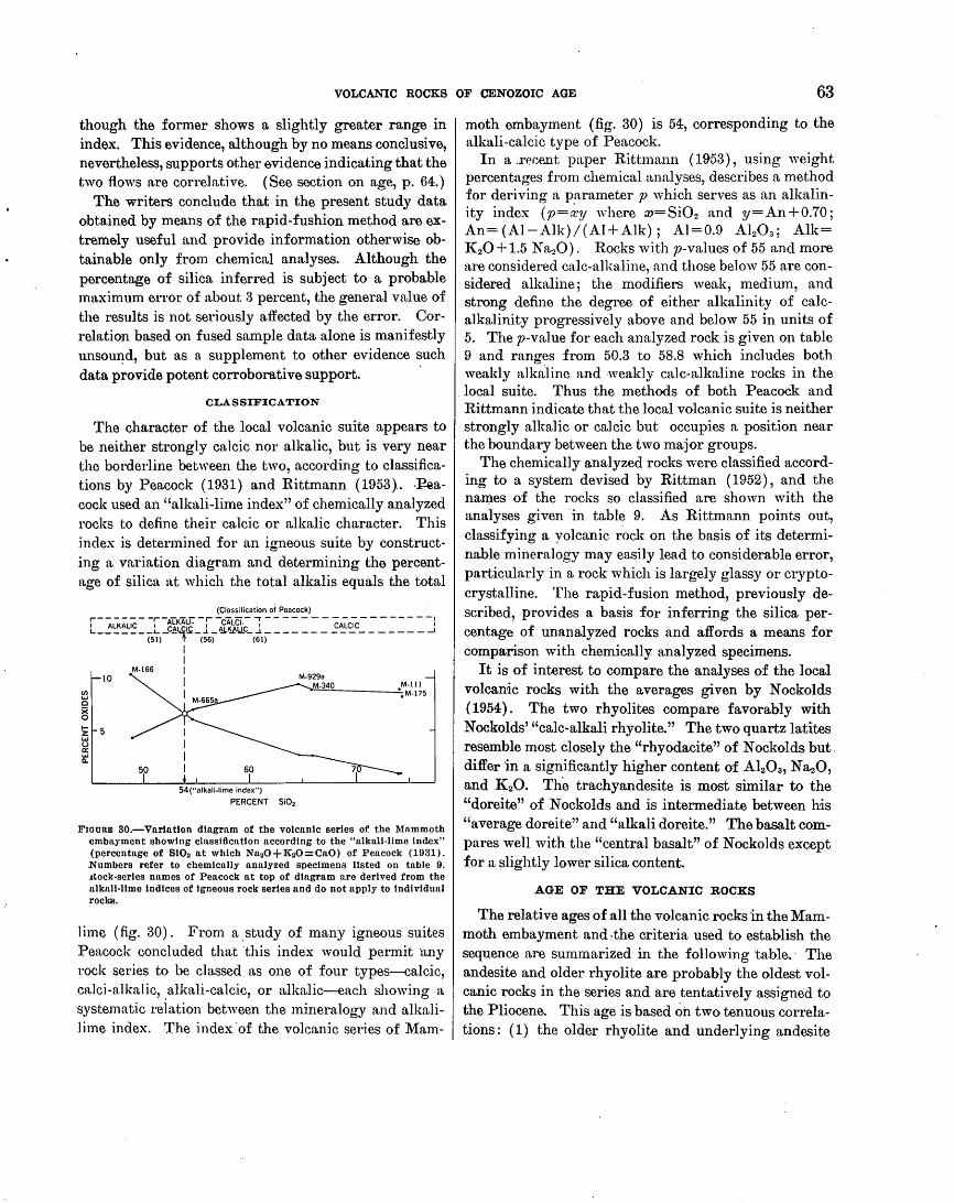
VOLCANITC ROCKS OF CENOZOIC AGE 63
though the former shows a slightly greater range in index. This evidence, although by no means conclusive, nevertheless, supports other evidence indicating that the· two fiows are correlative. (See section on age, p. 64.)
The writers conclude that in the present study data obtained by means of the rapid-fushion method are extremely useful and provide information otherwise obtainable only from chemical analyses. Although the percentage of silica inferred is subject to a probable maximum error of about 3 percent, the general value of the results is not seriously affected by the error. Correlation based on fused sample data alone is manifestly unsom~d, but as a supplement to other evidence such data provide potent corroborative support. ·
CLASSIFICATION
The character of the local volcanic suite appears to be neither strongly calcic nor alkalic, but is very near the borderline between the two, according to classifications by Peacock ( 1931) and Rittmann ( 1953).. ..l~ea
cock used an "alkali-lime index" of chemically analyzed rocks to define their calcic or alkalic character. This index is determined for an igneous suite by constructing a variation diagram and determining the percentage of silica at which the total alkalis equals the total
50 60
54("alkali-lime index")
PERCENT Si02
Frouam 80.-Varlatton diagram of the volcanic series of the Mammoth cmbnyment showing classificntlon accord·ing to the "alkali-lime index" (percentage of Si02 at which Nn20+K20=Ca0) of Peacock (1931). Numbers refer to chemically analyzed specimens listed on table 9. J.tock-sertes names of Peacock at top of diagram are derived from the alknll-llme indices of igneous rock series and do not apply to individual rocks.
lime (fig. 30). From a _study of many igneous suites Peacock concluded that this index would permit ·any rock series to be classed as one of four types-calcic, cn.lci-alkalic, .alkali-calcic, or aJka.lic-each showing a systematic relation between the mineralogy and alkalilime index. The index "of the volcanic series of Mam-
moth embayment (fig. 30) is 54, corresponding to the alkali -calcic type of Peacock.
In a .re~P..nt paper Rittmann (1953), using weight percentages from chemical analyses, describes a method for deriving a parameter p which serves as an alkalinity index (p=~y where w=Si02 and y=An+0.70; An={Al-Alk)/(Al+Alk); Al=0.9 Alz03; Alk= K 20+1.5 Na20). R~ks with p-values of 55 and more are considered calc-alkaline, and those below 55 are considered alkaline; the modifiers weak, medi urn, and strong define the degree of either alkalinity of calcalkalinity progressively above and below 55 in units of 5. The p-va]ue for each analyzed rock is given op. table 9 and ranges from 50.3 to 58.8 which includes both weakly alkaline and weakly calc-alkaline rocks in the local suite. Thus the methods of both Peacock and Rittmann indicate that the local volcanic suite is neither strongly alkalic or calcic but occupies a position near the boundary between the two major groups.
The chemically analyzed rocks were classified according to a system devised by Rittman ( 1952), and the na~es of the rocks so classified are shown with the analyses given ·in table 9. As Rittmann points out, classifying a yolcanic rock on the basis of its determinable mineralogy may easily lead to considerable error, particularly in a rock which is largely glassy or cryptocrystalline. The rapid-fusion method, previously described, provides a basis for inferring the silica percentage of unanalyzed rocks and affords a means for comparison with chemically analyzed specimens.
It is of interest to compare the analyses of the local volcanic rocks with the averages given by Nockolds (1954). The two rhyolites compare favorably with Nockolds' "calc-alkalirhyolite." The two quartz latites resemble most closely the "rhyodacite" of N ockolds but. differ in a significantly higher content of Alz03 , N azO, and KzO. The trachyandesite is most similar to the "doreite" of N ockolds and is intermediate between his "average doreite" and "alkali doreite." The basalt compares well with the "central basalt" of N ockolds except for a slightly lower silica content.
AGE OF THE VOLCANIC ROCKS
The relative ages of all the volcanic rocks in the Mammoth embayment and: the· criteria used to establish the sequence are summarized in the following table. · The andesite and older rhyolite are probably the oldest volcanic rocks in the series and are tentatively assigned to the Pliocene. This age is based on two tenuous correlations: ( 1) the older rhyolite and underlying andesite

64 GEOLOGY AND MINERAL DEPOSITS, MOUNT MORRISON QUADRANGLE, CALIF.
Criteria used to establish tke relative aues .of tke volcanic units
Volcanic units in probable order of
increasing age
A. Olivine-bearing quartz latite.
B. Basalt.-------------
C. Bishop tuff ________ _
Inclusions
G
F
G
Overlain by (inferred from · relative topop:raphic position)-
A
B
Degree of dissection
greater than-
B
Before earliest
glaciation
After earliest glaciation, before later glaciation
X
Overlain by lake beds of Long Valley
Lake
X
Remarks
Unglaciated.
Flowed through .gorge cut into the Bishop tuff of Gilbert (1938), west of the Arcularius Ranch.
D. Younger rhyolite ___ · G ---------------- ---------------- ----------------
X
X
X
X
X
Overlies till of the Sherwin glacial stage along Owens River Gorge (Putnam, 1952).
E. Quartz latite ________ ---------------- ---------------- A, B, C, D X F. Older rhyolite_______ G ---------------- A, B, C, D X G. Andesite-----~---------------------- F, D, C A, B, C, D X
may be correlatives of lithologically similar units capping Glass Mountain, which forms the northeastern limit of Long Valley in the Casa Diablo Mountain quadrangle (see also pL 4) ; ( 2) the units on Glass Mountain are considered by Gilbert ( 1941) to be of Pliocene age on the basis of their position in a volcanic sequence that correlates with a similar sequence in the Hawthorne quadrangle, Mineral County, Nev. There, the pertinent units overlie the Esmeralda formation of late Miocene and early Pliocene age.
The correlation of the andesite and older rhyolite with the lithologically similar rocks in the Glass ·Mountain area (Rinehart and Ross, 1957) is based on the belief that these units were once continuous across Long Valley and that Long Valley was downfaulted. suhsequent to their extrusion. This possibility was suggested in part by Gilbert ( 1941, p. 795) in discussing the rhyolite of the Glass Mountain area. He states: "Subsequently this rhyolite, several thousand feet thick near Glass Mountain, was displaced by faulting so that· its southern part must now lie beneath the alluvium in Long Valley." Gilbert apparently accepted Chelikowsky's (1940) mistaken conclusion, however, that the rhyolite of the Mammoth embayment intruded the Long Valley Lake sediments and that its maximum age w:as middle Pleistocene, which excluded consideration of possible correlation of the rhyolites on the two sides of Long Valley.
The remnants of volcanic flows in the Sierra Nevada in the Mount Morrison quadrangle are regarded as Tertiary in age, chiefly because the andesite on McGee Mountain is overlain by till of the ~fcGee stage (Blackwelder, 1931), hence it predates the earliest known glaciation in the Sierra Nevada. Also, the refractive indices of fused samples of the andesite flow remnants show a remarkable overlap with the indices from the Mammoth-Dry. Creek flow (fig. 29) and thereby suggest possible correlation. ~
The quartz latite, exposed near the center of the western boundary of the quadrangle, is tentatively considered to be Tertiary in age for two related reasons :
(1) west of the quadrangle where the rocks is best exposed on Mammoth Mountain, it is deeply dissected and shows no recognizable constructional form; (2) preliminary observations in the Devils Postpile quadrangle to the west reveal patches of till, which may be equivalent to the McGee till resting on quartz latite remnants that cap the main Sierra Nevada drainage divide at altitudes above 10,000 feet. The quartz latite is therefore older than e~rly, possibly the earliest, glaciation.
Three of the remaining four volcanic units are inferred to be of Pleistocene age, chiefly because, although they are only slightly deformed and dissected relative to the older rhyolite and andesite, they show evidence of glaciation. The olivine-bearing quartz latite flow, ·which shows no evidence of having been glaciated and appears to have a thinner pumice cover than the other volcanic rocks, may be of Recent age. A small boulder deposit on the northernmost ridge of older rhyolite west of U.S. Highway 395 (see pl. 1) contributes additional evidence that considerable time elapsed between the eruption of the older and younger rhyolites. The deposit, presumably glacial till, consists of rounded and locally striated cobbles and boulders of granitic, metamorphic, and volcanic rocks, some as much as 3 feet in diameter. The source of two distinctive metavolcanic boulders in the till is at least 6 miles to the west or southwest. West of the till there is a mass of younger rhyolite that would have been overridden by the glacier that deposited the till had the rhyolite mass existed at that time. Although the younger rhyolite is flanked on the northwest by a low lateral moraine, it shows no evidence of having been overridden by a glacier, and is inferred to be interglacial in age.
· .GLACIAL DEPOSITS OF QUATERNARY AGE
Each of the major canyons in the Sierra Nevada escarpment has a high pile of glacial till at its mouth. Most of the till forms well-defined moraine, but small patches of till and erratics lie near the heads of the canyons, on some upland surfaces, and at a few localities in the lowlands north of the range front. These
GLACIAL DEPOSITS OF QUATERNARY AGE 65
features attest to widespread glaciation during the Pleistocene.
J. D. Whitney ( 1865, p. 450-455) first studied the effects of glaciation in the Sierra Nevada, and l(nopf (1918) was the first to prepare a map of. a part of the rnnge showing the concept of multiple glaciation.
· Blackwelder ( 1931) subsequently recognized four distinct glacial stages in the eastern part of the range, which he named, from oldest to youngest, McGee, Sherwin, Ta.ho3, and Tioga. These stages are still used as a standard section for the eastern Sierra Nevada. Blackwelder (1931, p. 870) also suggested that an additional stage might exist between the Sherwin and Tahoe stages-a sugg-estion recently supported by Putnam ( 1949, p. 1291) who described a pre-Tahoe moraine in the .Tune Lake area that shows better preservation of form than is typical of till of the Sherw.in stage. l(essali (1941b) examined glacial deposits at the mouths of 12 canyons in the eastern Sierra Nevada, from Rock Creek on the south to Lundy Canyon on the north, and interpreted the geometrical arrangement of the inorltines as evidence for as many as five major glacial advances, in some places. l-Ie made no attempt, however, to correlate them with the stages of Blackwelder. On the west side of the range the standard glacial section is· based on the work of :Matthes (1930) in. Yosemite Valley. T-Ie has recognized three separate ice advances, which are. from oldest to youngest the Glacier Point, El PortnJ, and 'V'isconsin. Blackwelder ( 1931), as a resnlt of a field conference with l\iaJthes, made the following tentn.tive correlations between the east and west sides of the Sierra Nevada: " (a) the 'Visconsin stage of 1\intthes ·includes both the Tioga and Tahoe stages, (b) the El Portal stage is the same as the Sherwin, (c) t.he Glacier Point Point stage is probably not distinct from the latter [Sherwin], and (d) there is, as yet, insufficient evidence of the McGee stage in the Merced River basin." Recent wo.rk.'on the west side of. the range by Birman (1954 and 1959) is still in progress, but he has already pointed out. further complexities in the glacial history. lie· has distinguished three groups of glacinJ deposits (Groups I, II, and III) representing seven glacinl advances (Birman, 1~59). The oldest glacial deposits, those of Group I, he correlates with f'.he Sherwin stage of Blackwelder (lDBl). Deposits of Group II represent three glacial advances, the oldest and youngest of which correlate "~ith the Tahoe and Tioga of Blackwelder, separated by an. intervening hit:.he·rto unrecognized advance. Group III, the youngest deposits, represent three adyances all of ·post:.'Yisconsin age.
T'his brief summation of some of the major contrjbutions to the study of the glaciation of the Sierra Ne-
vada emphasizes the increasing complexity of the problem that results from increased study.
The interpretation of the glacial history presented in this report is based chiefly on a study of the physiographic features of the moraines as revealed by aerial photographs. It by no means constitutes an exhaustive study. No attempt was made .to study the internal stratigraphy of the glacial deposits nor were boulders systematically traced to their sources-studies that will be required before the glacial history is reliably elucidated. Because of these limitations, only the most clearly defined subdivisions of the glacial deposits are delineated on plate 1. The writers nevertheless believe that insofar as an interpretation of the glacial history depends on the study of form, aerial photographs provide the best means presently available for such study.
Glacial deposits representing at least four distinct periods of glaciation are distinguished on plate 1 and include, from oldest to youngest, boulder deposits of McGee Mountain, older moraine, younger moraine, all Pleistocene in age, and post-Pleistocene rock glacier deposits. Four additional glacial units are also distinguished on plate 1; these units typically include either till of one or more of the above. ages or are the probable age equivalent of one of the units, but they are sufficiently different in composition or physical setting to be separately delineated. Besides the four ages represented by the deposits shown on plate 1, evidence exists at a few localities suggesting that one and possibly both of the moraines may include material deposited during two distinct glacial advances.
In describing tills of the various stages, Blackwelder (1931) refers to several localities in the Mount Morrison quadrangle,. Unfortunately, his report includes no geologic map and does not make completely clear the position of the contacts between tills of some. of the stages. For this reason it was not considered advis~ble to assign the stage names of Blackwelder to the units distinguished on plate 1. However, the writers' interpretation of the probable correlation is shown on figure 31.
The distinction among tills of various ages was based chiefly on six criteria: (1) relative positions of moraines along canyons, (2) state of preservation of constructional form, ( 3) amount of regional deformation and bedrock erosion since deposition of till, ( 4) relative amounts of displace·ment along faults in individual tills, ( 5) stream downcutting and drainage changes, and ( 6) superposition of tills. The relative positions of moraines along the canyons (1) is perhaps the best single criterion of age that can be used in the area, particularly in distinguishing map units of older moraine and younger moraine. These units and the tentative subdivisions within them are typically arranged in a nested
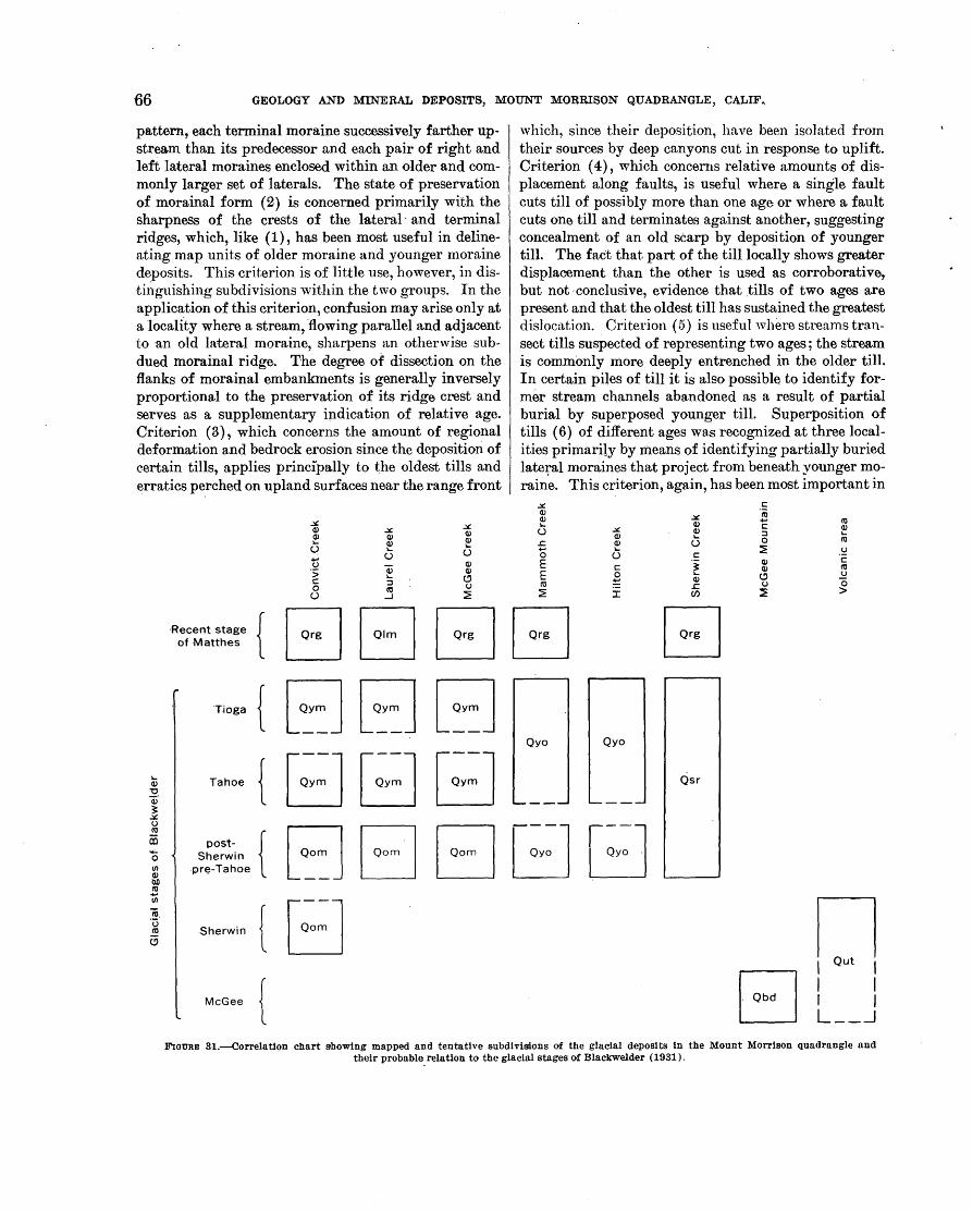
·66 GEOLOGY AND MINERAL DEPOSITS, MOUNT MORRISON QUADRANGLE, CALIF~
pattern, each tenninal moraine successively farther upstream than its predecessor and each pair of right and left lateral moraines enclosed within an older and commonly larger set of laterals. The state of preservation of morainal form (2) is concerned primarily with the sharpness of the crests of the lateral · and terminal ridges, which, like (1), has been .most useful in delineating map units of older moraine and younger moraine deposits. This criterion is of little use, however, in distii1guishing subdivisions within the two groups. In the application of this criterion, confusion may arise only at a locali.ty where a stream, 'flowing parallel and adjacent to an old lateral moraine, sharpens an otherwise subdued morainal ridge. The d~gree of dissection on the flanks of morainal embankments is generally inversely proportional to the preservation of its ridge crest and serves as a supplementary indication of relative age. Criterion (3), which concerns the amount of regional deformation and bedrock erosion since the deposition of eertain tills, applies principally to the oldest tills and erratics perched on upland surfaces near the range front
,:tJ:. ,:tJ:. Q) ,:tJ:. Q) Q)
Q)
u Q) Q)
u u +'
Q) () Qi ·:; Q) lo.. (!) c ::J
0 ro ()
(.) ...J ~
which, since their deposition, have been isolated from their sources by deep canyons cut in response to uplift. Criterion ( 4), which concerns relative amounts of displacement along faults, is useful where a single fault cuts till of possibly more than one age or where a fault cuts one till and terminates against anothe,r, suggesting concealment of an old scarp by deposition of younger till. The fact that. part of the till locally shows greater displacement than the other is used as corroborative, but not ·conclusive, evidence that tills of two ages are present and that the oldest till has sustained the greatest dislocn,tion. Criterion ( 5) is usefu 1 'vhere streams transect tills suspected of representing two ages; the stream is commonly more deeply entrenched in the older till. In certain piles of till it is also possibl~ to identify former stream channels abandoned as a result of partial burial by superposed younger till. Superposition of tills (6) of different ages was recognized at three localities primarily by means of identifying partially buried late:ral moraines that project from beneath younger moraine. This criterion, again, has been most important in
,:tJ:. Q) Q) lo..
(.) ,:tJ:. Q)
.r: Q) +' u 0 E c E 0 ro ~
~ :r
.!: ,:tJ:. ro Q)
+' ro c ~ Q) ::J u 0 ro
c ::?! .~
'i Q) c Q) ro
lo.. (!) ~ Q) .r: () 0 Cf) ~ >
Hecent stage of Matthes {EJEJBEJ EJ
Tioga
Tahoe
postSherwin
.pre-Tahoe
.Sherwin
McGee
{EJEJEJ {EJBEJ {EJEJEJBB {EJ
Qyo Qyo
{
Qsr
n I out I I I I I L __ _j
FIGURE 31.--Correlatlon chart showing mapped and tentative subdivisions of the glacial deposits in the Mount Morrison quadrangle and their probable relation to the glacial stages of BlackWelder (1931).

GLACIAL DEPOSITS OF QUATERNARY AGE 67
separatino· older morame from younger moraine deposits.
BOULDER DEPOSITS OF McGEE MOUNTAIN
The broad upland area of McGee Mountain is, in part, capped by scattered, formless boulder deposits, which at first glance appear to be composed chiefly of Round Valley Peak granodiorite, the nearest exposures of which are 3 miles to the south (fig. 32, see also figs. 26 and 27). Closer observation reveals an abundant admixture of smaller boulders and cobbles of metamorphic rocks that are foreign to formations exposed on McGee Mountain (fig. 32). The largest boulders of granodiorite are nearly 30 feet in maximum dimension and many are 10 to 20 feet (fig. 33).
The boulders have shed considerable gruss, which has undoubtedly buried much of the material of smaller size, and the dark dioritic inclusions in the granodiorite stand out in marked relief giving the boulders a knobby surface. The weathering of the boulders apparently
occurs only in a thin outer zone, for the interior appears fresh when broken. The voluminous gruss and the relief shown by the mafic inclusions suggest that the boulders have probably been reduced in size by several inches as a result of the migration inward of this weathering zone. Three separate boulder-covered areas occur on McGee Mountain at altitudes ranging from 9,400 to 10,700 feet, and scattered boulders of granodiorite are found toward the summit east of the largest boulder deposit. Also, a small patch of granitic boulders on the east side of the canyon of McGee Creek southeast of Horsetail Falls, at an altitude of about 11,000 feet, may be related in age to the McGee Mountain deposits.
The boulder deposits constitute the till of Blackwelder's McGee stage ( 1931), the earliest of his four stages of glaciation, although Blackwelder expressed some reservation about the glacial origin because of a lack of essential criteria for distinguishing between mudflow, landslide, and glacial deposits. However,
FIGURE 3·2.-VIew looking southward up McGee Creek from boulder deposit atop McGee Mountain. Metamorphic rocks in the middle distance are In contact with Round Valley Peak granodiorite about midway along the visible course of i\IcGee Creek where the tr~ growth becomes dense; the contact is roughly parallel to the plane of the photograph . The area south of the contact is the only possible source for the boulder deposit in the foreground. Valley ftoor is 2,500 feet below the camera.
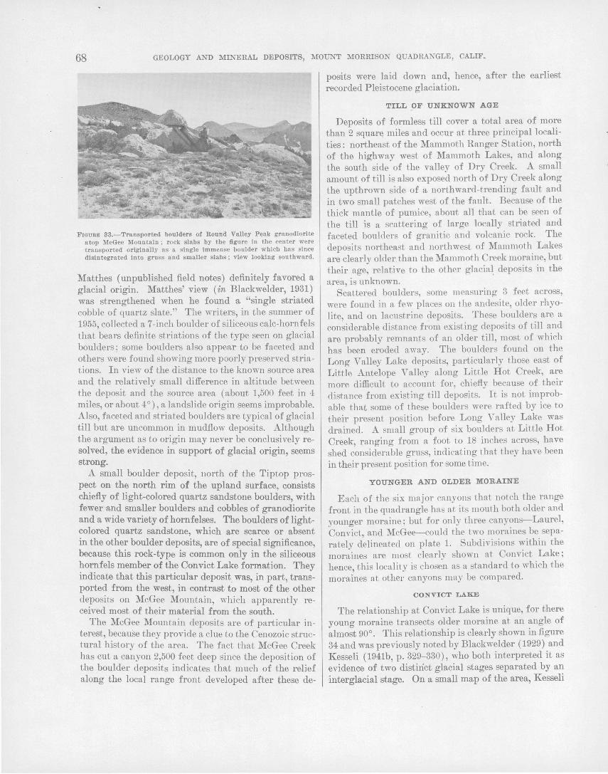
68 GEOLOGY AND MINERAL DEPOSITS, MOUNT MORRISON QUADRANGLE, CALIF,
Fwuam 33.-Transported boulders of Round Valley Peak granodiorite atop McGee Mountain ; rock slabs by the figure in the center were transported originally as a single Immense boulder which has since disintegrated Into gruss and smaller slabs; view looking southward.
Matthes (unpublished field notes) definitely favored a glacial origin. Matthes' view (in Blackwelder, 1931) was strengthened when he found a "single striated cobble of quartz slate." The writers, in the summer of 1955, collected a 7-inch boulder of siliceous calc-hornfels that bears definite striations of the type seen on glacial boulders; some boulders also appear to be faceted and others were found showing more poorly preserved striations. In view of the distance to the known source area and the relatively small difference in altitude between the deposit and the source area (about 1,500 feet in 4 miles, or about 4°), a landslide origin seems improbable. Also, faceted and striated boulders are typical of glacial till but are uncommon in mudfiow deposits. Although the argument as to origin may never be conclusively resolved, the evidence in support of glacial origin, seems strong.
A small boulder deposit, north of the Tiptop prospect on the north rim of the upland surface, consists chiefly of light-colored quartz sandstone boulders, with fewer •and smaller boulders and cobbles of granodiorite and a wide variety of hornfelses. The boulders of lightcolored quartz sandstone, which are scarce or absent in the other boulder deposits, are of special significance, because this rock-type is common only in the siliceous hornfels member of the Convict Lake formation. They indicate that this particu}ar deposit was, in part, transported from the west, in contrast to most of the other deposits on McGee Mountain, which apparently received most of their material from the south.
The McGee Mountain deposits are of particular interest, becau.Se they provide a clue to the Cenozoic structural history of the area. The fact that McGee Creek has cut a canyon 2,500 feet deep since the deposition of the boulder deposits indicates that much of the relief along the local range front developed after these de-
posits were laid down and, hence, after the earliest recorded Pleistocene glaciation.
TILL OF UNKNOWN AGE
Deposits of formless till cover a total area of more than 2 squar~ miles and occur at three principal localities: northeast of the Mammoth Ranger Station, north of the highway west of Mammoth Lakes, and along the south side of the valley of Dry Creek. A small amount of till is also exposed north of Dry Creek along the upthrown side of a northward-trending fault and in two small patches west of the fault. Because of the thick mantle of pumice, about all 1Jhat can be seen of the till is a scattering of large locally striated and faceted boulders of granitic and volcanic rock. The deposits northeast and northwest of Mammoth Lakes are clearly older. than the Mammoth Creek moraine, but their age, relative to the other glacia~ deposits in the area, is unknown.
Scattered bqulders, some measuring 3 feet across, were found in a few places on the andesite, older rhyolite, and on lacustrine deposits. These boulders are a considerable distance from existing deposits of till and are probably remnants of an older ti1l, most of which has been eroded a\Yay. The boulders found on the Long Valley Lake deposits, particularly those east of Little Antelope Valley along Little Hot Creek, are more difficult to account for, chiefly because of their distance from existing till deposits. It is not improbable that some of these boulders were rafted by ice to their present position before Long Valley Lake was drained. A small group of six boulders at Little Hot Creek, ranging from a foot to 18 inches across, have shed considerable grnss, indicating that they have been in their present position for some time.
YOUNGER AND OLDER MORAINE
Each of the six major canyons that notch the range front in the quadrangle has at its mouth both older and younger moraine; but for only three cany?ns----Laurel, Convict, and McGee-could the two morames be separately delineated on plate 1. Subdivisions within the moraines are most clearly shown at Convict Lake; hence, this locality is chosen as a standard to which the moraines at other canyons may be compared.
CONVICT LAKE
The relationship at Convict Lake is unique, for there
Younrr moraine transects older moraine at an angle of 0 . fi almost 90°. This relationship is clearly shown m gure
34 and was previously noted by Blackwelder (1929) and Kesseli ( 1941b, p. 329-330), who both interpreted it as evidence of two distinct glacial stages separated by an ·interglacial stage. On a small map of the area, Kesseli
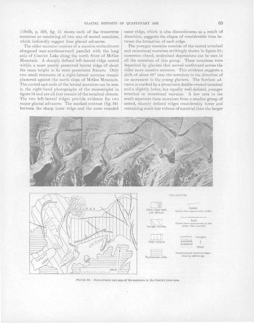
GLACIAL DEPOSITS OF QUATERNARY AGE 69
( 1941b, p. 329, fig. 5) shows each of the ~ransverse moraines as consisting of two sets of nested moraines, which indirectly suggest four glacial advances.
The older moraine consists of a massive embankment elongated east-northeastward parallel with the long axis of Convict Lake along the north front of McGee Mountain. A sharply defined left-lateral ridge nested within a more poorly preserved lateral ridge of about the same height is its most prominent feature. Only two small remnants of a right-lateral moraine remain plastered. against the north slope of McGee Mountain. The curved east ends of the lateral moraines can be seen in the right-hand photographs of the stereotriplet in figure 34 and are all that remain of the terminal closure. The two left-lateral ridges provide evidence for two major glacial advances. The marked contrast (fig. 34) between the sharp inner ridge and the more rounded
outer ridge, which is also discontinuous as a result of dissection, suggests the elapse of considerable time between the formation of each ridge.
The younger moraine consists of the nested terminal and recessional moraines strikingly shown in figure 34; numerous closed, undrained depressions can be seen in all the moraines of this group. These moraines were deposited by glaciers that moved northward across the older more massive moraine. This evidence suggests a shift of about 90° near the terminus in the direction of ice movement in the young glaciers. The farthest advance is marked by a prominent double-crested terminal and a slightly lower, but equally well-defined, younger terminal or recessional moraine. A low area to the south separates these moraines from a smaller group of nested, sharply defined ridges considerably lower and containing much less volume of material than the larger
I \~~~ Talus, slope wash ,
and alluvium
rs=sJ Younger moraine
DIIJ Older moraine
Pre-Cenozoic rocks
EXPLANATION
------Contact
Dashed where approximately locofed
Fault Dashed where approximately located,
dotted where concealed
Ulltulfl/111/111111/l
XXX X XXX 00000000
Youngest
t Oldest
Constructional morainal ridges showing relative age
FIGURE 34.-Stereotriplet and map of the moraines In the Convict Lake area.
70 GEOLOGY AND M~ERAL DEPOSITS, 0 MOUNT MORRISON QUADRANGLE, CALIF.,
ones to the north; this group of deposits is the youngest of those mapped as younger moraine. The distinc-: tion between the two groups of younger moraines is also well shown in the series of sharp nested ridges east of the lake. Examination of the left-hand pair of photographs in figure 34 shows that at both localities, the state of preservation of constructional forms is identical. A left-lateraJ moraine, apparently related to the younger of the two groups of terminal moraines, extends southwest about a mile along the northwest side of the lake and consists of a plaster of boulders against the bedrock wall. A probable age difference between the two sets of younger moraines is further supported by the relations observed along a fault located about three-fourths of a mile north of the lake. The fault cuts the ridges of ·the outer set of moraines but terminates against the ridges' of the inner or younger group, suggesting that the faulting occurred before the younger moraines were formed.
In considering the relationship between the older and younger moraine, the possibility cannot be eliminated that the pair of morainal ridges in the older moraine correlate with the northernmost pair in the younger moraine. In other words each of the glaciers that constructed the two pairs of ridges may hav~ split into two lobes at the vertex of the angle between the older and younger moraines. · The pairs of lateral ridges on both sides of the high point northeast of Convict Lake are close to being mutually continuous, athough the ridges east of the high point are a little higher than those to the north; the ambiguity of their relationship is evident on figure 34. If they are indeed continuous then they almost surely were constructed by lobes of a single glacier. On the other hand, the lateral ridges, and particularly the remnants of the terminal arcs, are less distinct in the older moraine than in the younger, suggesting that the latter has sustained a longer period of erosion. The writers regard the evidence as inconclusive although they favor the age sequence shown on figure 34, chiefly on the basis of the greater dissection in the older moraine.
The relation of the moraine in the tributary canyon southeast of the lake to the moraines at the mouth of Convict Canyon is uncertain, although it is clear that the group of young morainal ridges east of the lake were not overridden by a glacier from the tributary canyon. Judging from its source, which is 3 miles SQuth of Convict Lake at the base of Mount Aggie at an altitude of about 10,800 feet, the canyon, nevertheless, must surely have contained ice during the interval represented by the younger moraine and for this reason the voluminous moraine that occupies all but the upper fourth of the canyon is shown as younger moraine. Its form
is entirely different from moraines elsewhere in the quadrangle; it forms a rather symmetrical ridge along the axis of the canyon instead of forming the usual lateral moraines along the margins and along the upper two-thirds of its length the moraine shows features resembling kame and kettle topography. According to Flint (1957, p. 151) kame and kettle topography is indicative of stagnant ice; so, although a glacier may have occupied the canyon, it did not advanced beyond the canyon mouth during the time represented by the younger moraine at the mouth of the major canyon. In fact, its terminus was probably no closer than a mile from the canyon mouth.
McGEE CREEK
Only a two-fold subdivision of the McGee Creek moraine is clear from aerial photographs. The distinction is based on the superposition of young well-formed moraine on a so mew hat dissected older moraine. The trend of the morainal ridges suggests that the older glaciers extended farther into Long Valley and curved northward through a greater angle than the younger glacier. Differences in height and trend of the lateral moraines of the two glaciers can be seen on figure 35. Remnants of both right and left laterals and remnants of nested inner ridges can easily be distinguished in the older moraine. l{esseli (1941b, p. 331, fig. 7) shows a map of the McGee Creek moraines in which he also interprets two groups of moraines as representino- two major glacial advances.
0
The younger moraine is characterized by extremely . sharp and undissected lateral ridges that extend from well within the bedrock canyon walls to a mile beyond the range front. A continuation of the left lateral is preserved as a plaster of boulders that extends westward from the mouth of the canyon to the right-angled bend in McGee Creek. The terminal moraine has been
. destroyed by the axial stream but low, arcuate ridges, presumably recessionals, are abundantly distributed along the canyon floor for 1~ miles soutJhwest of the northernmost extent of the younger moraine.
Judging from the states of preservation of the morainal forms, the subdivision into older and younger moraines at McGee Creek is probably equivalent to that made at Convict Lake. Although the total volume of material involved in each of the two localities is different, the proportio~ between older and younger moraine at each locality appears to be about the same. The recessional moraines may be ·equivalent to the youngest moraine distinguished in the Convict Lake area, but the distinction is much more poorly defined at McGee Creek.

GLACIAL DEPOSITS OF QUATERNARY AGE 71
LAUREL CREEK
At the mouth of Laurel Creek (fig. 36) a well-preserved terminal moraine and its connected laterals stand in marked contraSt to the lower subdued ridges of till that project beyond the terminal, revealing the presence of _glacial deposits of two distinct ages.
The older moraine,_ which projects northward from beneath the younger moraine, shows different topographic form on opposite sides of the axial stream. To the east is a fairly well preserved set of lateral moraines between which there are two smaller and less distinct laterals. A stream apparently flowed for some time down the narrow depression between the two sets of laterals, as suggested by the size of the alluvial fan at its base, which is seveml times larger than the fan presently being formed by Laurel Creek; the stream apparently destroyed all traces of the old terminal mo-
raine. West of the present stream, the moraine is formless except for a small isolated and well-preserved ridge nestled against the massive moraine of Sherwin Creek, visible at the extreme right side of figure 36. Although this ridge is closer to Sherwin Creek than to Laurel Creek, the vegetation cover is similar to that on the Laurel Creek moraine and quite unlike that supported by the Sherwin Creek deposits (fig. 36). The ridge appears to be of about the same age as the. old lateral moraines to the east and may have been deposited by a separate lobe of the glacier that formed the eastern ridges.
The laterals and the connected terminal closure of the younger moraine form a prominent, horseshoe$haped ridge that is slightly notched by Laurel Creek. The laterals are sharp and undisseeted even where they cross· the mouths of deep gulleys tributary to the main
FIGURE 35.-View looking northward across McGee Creek moraine offset along the Hilton Creek faul t. Lower ridge to the righ t of offset ridges is a lateral ridge of an older moraine that was overridden in part by a younger glacier . McGee Mountain on t'be left; fault scarp can be trp.ced fo r a considerable distance a long the base of the mountain.
72 GEOLOGY AND MINERAL DEPOSITS, MOUNT MORRISON QUADRANGLE, CALIF.
canyon. Less than a quarter of a mile south of the imposing terminal moraine the western half of a younger and smaller terminal loop and an adjoining left-lateral stand more than 50 feet below the crest of the large lateral to the west. This represents a glacial
·advance possibly equivalent to the youngest subdivision of the Convict Lake moraine. Small scattered patches of till farther up the canyon, east of Laurel Lakes, are probably also related to this youngest glacial advance.
On a map of the Laurel Creek-Sherwin Creek area, Kesseli (1941b, p. 333, fig. 8) shows morainal ridges, which in his opinion indicate four separate glacial advances. The moraines of his youngest two advances generally agree with the younger and older moraines of the present writers. He designated the small isolated ridge alongside the massive Sherwin Creek moraine and another ridge of comparable size to the west of it as the oldest Laurel Creek moraine. Four other morainal ridges included in his second oldest advance were not recognized by the writers of this report, although in one or two places, piles of till occur at about the site where the ridges should be. No constructional form was recognized, however.
SHERWIN CREEK
The glacial deposits of Sherwin Creek undoubtedly contain material equivalent in age to the older and younger moraines of the other canyons, but they differ from those of the other canyons in two ways: (1) the
support of a rather dense forest in contrast to the usual sage-cover of moraines elsewhere (fig. 36), and (2) paucity of constructional form, particularly the absence of the high massive lateral ridges typical in other canyons. Both differences can be accounted for by the composition of the tills ; the till at Sherwin Creek consists entirely of granodiorite debris, whereas the till of ~ll other canyons except Hilton consists dominantly of metamorphic debris. The difference in vegetative cover is almost certainly due to rock composition, for granitic bedrock terrane at favorable altitudes is typically tree covered, whereas the metamorphic bedrock terrane at similar altitudes supports only scant tree growth. Another significant difference is in the size of the blocks comprising the two tills. At Sherwin Creek the till consists largely of huge blocks, many of which measure as much as 20 feet in one dimension, whereas in most of the other canyons the tills are composed chiefly of finer material.
Inasmuch as the basins drained by both Sherwin and Laurel Creeks are adjacent, of about equal size, and include about the same range in altitude, they should have similar glacial histories. Therefore, the marked difference in the form of the deposits at the two canyons must lie in the nature of the material comprising them, the most noticeable being the size of the constituent fragments. Although a marked difference in chemical composition between the tills also exists, it seems improbable that it would have any direct influence on the
FIGURE 36.-View looking southward at the moraines of Laurel and Sherwin Creeks. Laurel Creek moraine L. is composed of metamorphic rocli debris which supports the growth of sage only, whereas Sherwin Creek moraine, s, consists of granitic debris that supports a dense growth of trees. Road at left middle distance traverses alluvial fan, 0, deposited by Pleistocene Laurel Creek, which flowed between old dissected lateral moraines, QM . Terminal moraine of younger glacier, slightly notChed by Laurel Creek, is shown at Y. Present course of Laurel Creek and Its alluvial fan shown at L.
GLACIAL DEPOSITS OF QUATERNARY AGE 73
resulting shape of the deposits, hence the size of the debris fragments is the most important factor. Kesseli (1941b, p. 320) reached similar conclusions regarding the difference in form of the tills at the two canyons, for he states :
'l'he finer texture of the debris along Laurel Creek seems to have favored the nssumption by the glacier of the ideal tongue shape, wherens the mass of great blocks carried by the Sherwin Creek glncier prevented its taking such a form.
The ridges interpreted as lateral moraines and shown on pln.te 1 have rather sharp crests, although they all undoubtedly have been sharpened by streams that flow along them. I\:esseli (1941b, p. 332, fig. 8) shows moraines of three ages at Sherwin Cheek. The westernmost ridge shown on plate 1 represents Kesseli's oldest moraine, the paired 1 aterals to the east next youngest, and very low and ill-defined ridges east of the largest Sherwin Lake, Kesseli regards as the youngest.
Although remnants of constructional forms can be recognized here and there in the Sherwin Creek till, the writers feel that the relationships are too obscure to permit the accurate delineation of till of more than one age.
HILTON CREEK
TilJs of two ages are probably present in the Hilton Creek moraine, but the distinction between them is not sharp, and the moraine is shown undifferentiated on plate 1. Two well-defined lateral ridges and two small inner laterals, one merging with part of a, terminal moraine, constitute the dominant forms preserved. The inner partly preserved terminal moraine may represent a glacial advance during a stage distinctly later than that during which the large outer lateral moraines were formed. This suggestion is supported by the f~t that north of the small terminal.remnant, the moraine is considerably more dissected than it is to the south. If a contact were to be drawn, it would cross the stream slightly north of the arcuate terminal shown on plate 1. This subdivision, if valid, ·is probably equivalent to the subdivision of the older and younger moraines in the other canyons. The poorer foi·m of the .Hilton Creek 1noraine relative to better developed forms, such as are shown by the nearby McGee ·creek moraine, is probably due to differences in the composition of ·the till. Although a detailed examination of the till was not made, the terrain drained by Hilton Creek is dominantly granitic, whereas over half of that drained by McGee Creek is metamorphic. The composition of the till in each of the two canyons undoubtedly corresponds to the bedrock at its &ource.
I\:esseli briefly menti9ns moraines of two ages at Hilton Creek and shows their generalized positions on a map (1~41b, p. 331, fig. 7), but his two groups of mo.:.
raines do not coincide with the two suggested subdivisions of the writers. The younger moraines of Kesseli generally coincide with the trend of the morainal ridges shown on plate 1 and thus overlap both of the suggested younger and older moraines of the writers.
MAMMOTH CREEK
The moraine of Mammoth Creek occupies an area of more than 5 square miles and extends eastward 21;2 miles from the western boundary of the quadrangle, <;overing the entire floor of the valley from the Sierra Nevada front on the south, northward to the south edge of the volcanic field. The eastern terminus of the mo.raine is marked by a group of well-defined, concentric arcuate ridges that span the width of the valley and are breached in the center by Mammoth Creek. Some of the ridges stand more than 100 feet above the adjacen_t valley floor. This moraine is unique in the Mount Mor-. rison quadrangle in that it is a deposit of a piedmont . glacier with sufficient volume to cover the entire valley after emerging from the range. The principal area of accumulation was probably in the upper reaches of Mammoth and Cold Water Creeks, but small cirques immediately south and west of the Mammoth Lakes, west of the quadrangle, as well as the cirque near Mammoth Rock probably contributed to the volume of the glacier. ·
Although the moraine probably· includes material equivalent in age to both the old~r. ~~d younger moraines in other localities, the distinctionis not apparent in the aerial photographs, and the. moraine is shown undifferentiated on plate 1. The ·easternmost part ot the moraine is somewhat more dissected than other parts, but otherwise most of the constructional features appear to be about ~qually well preserved.
MORAINE OF LAUREL LAKES
· South of Laurel Lakes at the base of the cirque on the north: ·side of Bloody Mountain, two well-defined moraine _loops are nested inside each other, one about 800 fee~ sputh and 400 feet above the other. Each of the morai.f!.~S consists of a single continuous U-shaped ridge that encloses a basin behind it and lacks the surface corrugations typical of rock glaciers. The moraines are identical in shape with the large moraines at the mouths ~fthe canyons and appear to be products of true glaciers rather than of rock glaciers. Although considerably younger than the moraine at the mouth of the canyon, a substantial time interval must have elapsed between the advances represented by the two cirque moraines, because th~. lower supports a stand of mature pines, whereas no vegetation of any kind was observed on the upper.

74 GEOLOGY AND MINERAL DEPOSITS, MOUNT MORRISON QUADRANGLE, CALIF.
ROCK GLACIERS
About 30 rock glaciers occur in the quadrangle, at altitudes ranging :from 8,800 feet at the range :front southeast o:f Mammoth Rock to about 11,600 :feet at both Mount Morgan and Red Slate Mountain near the southern boundary o:f the quadrangle. They are tongueshaped masses o:f coarse debris that commonly head at the bases o:f steep cliffs where coarse debris is particularly abundant. They are stoop sided, generally ranging in height :from a :few tens o:f :feet to as much as 200 :feet. They range in length :from a :few hundred feet to a little more than a mile, and in width :from a few hundred :feet to a thousand :feet. At altitudes below 11,000 feet they characteristically show pronounced lateral and terminal ridges that commonly enclose basinlike depressions in the central part as illustrated in figure 37. At higher altitudes they typically show convex transverse and longitudinal profiles and lack the prominent terminal and lateral ridges o:f rock glaciers at lower altitudes. The surfaces of most rock glaciers show concentric corrugations, convex down valley, over most of their lengths.
The origins ascribed to rock glaciers are almost as numerous as the geologists who have described them, but most may be classified as o:f glacial origin, or an origin through various types of solifluction and mass wasting. Kesseli ( 1941a) studied rock glaciers along a segment of the eastern Sierra Nevada and cites the Sherwin Creek area as one showing typical examples of rock glaciers (called "rock streams" by him) . He concluded (1941a, p. 226) that "rock streams are glacial features." He apparently considered the "rock streams" as a special kind o:f moraine that :formed
N~---- 0
beneath ~ glacier :for he states, concerning some of the surface ridges (1941a, p. 227) :
The lower and shorter ridges that are in the main subparallel to the edges of the streams may well have resulted from a deformation of the deposit under the weight of the ice that passed over it.
Wahrhaftig and Cox recently made a detailed study o:f rock glaciers, both active and inactive, in the Alaska Range and recorded movement on the upper surface o:f one rock glacier averaging as much as 2.3 :feet per year for an 8-year period. They concluded (Wahrha:ftig and Cox, 1959, p. 432) that
Active rock-glaciers are masses of debris and interstitial ice and owe their motion to the flow of the ice. [l!'urther (p. 383)] • • • they require for their formation steep cliffs, a near-glacial climate cold enough for the ground to be perennially frozen, and bedrock that breaks by frost action into coarse blocky debris with large interconnected voids.
The rock glaciers in the Mount Morrison quadrangle were studied chiefly by means o:f aerial photographs; none were examined in detail except to observe that the debris composing them consists largely of huge boulders, many as much as 20 :feet across .. Also, the individual boulders that compose the deposits are commonly precariously balanced, particularly in the higher altitudes, and some, as large ·as an automobile, may roll or tip when stepped on. Aerial photographs of the rock glaciers in the Mount Morrison quadrangle, when compared with photographs o:f those described by Wahrhaftig and Cox, show that in most recognizable details the rock glaciers in both 'areas correspond almost exactly; hence, they are inferred to be similat' in ongm. The contrast in longitudinal and transverse
1000 FEET
FrGURE 13.7.-Stereoscopic pair of aerial photographs of a large, inactive rock glacier in Sherwin Creek. The markedly concave transverse profile Is typical o.f inactive rock glaciers ln. the area and reflects the former existence of a substantial ratio of ice to debris. The growth of trees on the rock glacier further attests to its dormancy. U.S. Forest Service photographs.

GLACIAL DEPOSITS OF QUATERNARY AGE 75
profiles between rock glaciers above and below 11,000 feet probably means that those above 11,000 feet are active, whereas those below are inactive. The general appearance of the ~inactive rock glaciers corresponds to some observed by W ahrhaftig and Cox ( 1959, p. 427) which have a "characteristic 'deflated' look." Furthermore, many rock glaciers below 11,000 feet support vegetation as evidence of their dormancy (fig. 37). The pronounced concavity of the inactive rock glaciers in this area may reflect the former existence of a somewhat larger ratio of ice to debl'is than those described by W ahrhaftig and Cox.
CORRELATION
Correlation of the glacial deposits with those in areas other than the east side of the Sierra Nevada is beyond the scope of this report, but tentative correlation with the glacial stages as set up by Blackwelder ( 1931) are suggested (fig. 31). Blackwelder shows . no maps of glacial deposits in the Mount Morrison quadrangle, although inferences can be drawn from a few of the photographs contained in his report. The only known . previous interpretation of the glacial' deposits of the quadrangle using the stages of Blackwelder was made by E. B. Mayo, whose map, unfortun•ately, was never _published. The McGee stage of Blackwelder is represented by' the boulder deposits atop McGee Mountain. This is the type locality of the McGee stage, but no correlative deposits are known in the quadrangle. It is possible that some of the till of unknown age, particularly the scattered boulders on the ridge northwest of Oasa Diablo Hot Springs (p. 2), may also be remnants of till of the McGee stage. Blackwelder made no specifi~ mention of deposits of the Sherwin stage in the quadrangle, although he did state that scattered bouldery deposits between June Lake and the Mammoth district, mostly buried by pumice and ash, 'are probably Sherwin in age. The designated "till of unknown age" (pl. .1 ). in the. volcanic area north of the range front may be a part of these deposits.
In discussing moraines of the Tahoe and Tioga stages Blackwelder (1931, p. 884) states:
The glaciers of the Tioga epoch were smaller than their predecessors, and so their moraines are now generally found arranged concentrleally within the earlier moraines of the Tahoe stage. The average relief of the moraine fronts is about 25 feet. Few are more than 75 feet and some are hardly 10 feet high. Being much less conspicuous, these you.nger moraines have often been overlooked or regarded as mere recessional loops related to the great laterals which are here referred to the preceding Tahoe stage. A rough estimate of relative bulks indicates that the great Tahoe moraines of Bridgeport Basin contain about 50 times as much material as the Tioga moraine loops in the same valley.
Consistent with the a,bove statement regarding the rela-689-998 0---'64--6
tive size and volume of the Tahoe and Tioga moraines, Blackwelder ( 1931, fig. 17, p. 893) shows a photograph of the Laurel Creek mor~ine, almost identical with figure 36, bearing the descri·ption as follows : "Most of the mass is of Tahoe age. * * * The breach in the rim is now partly filled by a smaller moraine lobe of the Tioga stage." (See also Blackwelder, 1931, p. 889.) Thus, according to his interpretation, it appears that the high lateral and breaclied terminal moraine is of Tahoe age, and that the small nested inner lobe shown on plate 1 is of. Tioga age. If the interpretation of the writers is correct-that the moraine bearing the high lateral and contiguous terminal ridge overlies a still older dissected moraine-the older moraine· must represent either the Sherwin stage or a stage intermediate between Sherwin and Tahoe. In another photogntph Blackwelder ( 1931, fig. 24, p. 901) shows a view of the younger moraine at the mouth of Convict Creek which he calls "moraine of Tahoe age." In view of his subdivision of the Laurel Creek moraine, it would therefore seem to be consistent in the Convict Lake area to assume that, of the younger moraine shown in plate 1 and figure 34, the small innermost nested loops would probably be considered Tioga in age by Blackwelder. At Convict Creek, however, the Tahoe till of Blackwelder is clearly younger than the large pile of moraine that lies to the east which may, itself, represent two glacial stages. In an earlier abstract, Blackwelder ( 1929) recognized the transverse relationship of the moraines at Convict Lake, but he did not attach stage names to them; and in his later comprehensive paper (Blackwelder 1931) he made no comment on the Convict Lake area, aside from the aforementioned photograph. Although Blackwelder makes no mention specifically of the moraine at McGee Creek, the relationships are similar to those at Laurel Creek; the small innermost nested loops shown on plate 1 are probably equivalent to Blackwelder's Tioga, the high lateral ridges represent Tahoe, and the somewhat more dissectecl moraine beyond· is pre-Tahoe in age (fig. 35).
The subdivisions of the moraines of Laurel, Convict, and McGee Creeks shown on plate 1, therefore, apparen~ly separate the Tahoe of Blackwelder from an older moraine not recognized by him. The distinction between Tahoe and older moraine is not sharply defined except at Convict Creek, but at all three localities the form of the older moraine is better preserved than till assigned by Blackwelder to his Sherwin stage, supporting his belief in the existence of a glacial stage between Sherwin and Tahoe. The correlation cha1t on figure 31 shows the subdivisions of p1ate 1, and the more tentative subdivisions suggested in the discussion, related to the stages of Blackwelder.

76 GEOLOGY AND MINERAL DEPOSITS, MOUNT MORRISON QUADRANGLE, CALIF.
The moraine of Laurel Lakes and the rock-glacier deposits, which are probably of about the same age, are not discussed by Blackwelder. It seems likely that these deposits are rebtecl to the rejuvenation of the cirque glaciers at a very recent date. In this regard, Matthes ( 1942, p. 212--213) states:
There is a notable absence of any gradational series of successively younger moraines leading from the Wisconsin moraines in the canyons below to the fresh-looking modern moraines that lie close to the ice fronts, and there is nothing to suggest that these modern moraines were formed merely by the last of a long series Of recessional stages of the glaciers. They form an entirely separate group of very recent origin. Their volume of rock waste moreover, is too small to represent an accumulation of 10,000 years or more. There is thus, on this score also, good reason to believe that the present glaciers of the Sierra Nevada * * * are creatures of the cooler and more snowy period that followed the "climatic optimum." They are successors to, rather than remnants of, the large glaciers of the Pleistocene Epoch, and their age is presumably * * * about 4,000 years.
Putnam (1950), also, mentions small fresh moraines in the upper reaches of glacial canyons, particularly near the Tioga Pass entrance to Yosemite National Park, that may be post-Pleistocene in age.
LACUSTRINE DEPOSITS OF QUATERNARY AGE
During part of the Pleistocene epoch, Long Valley was occupied by a lake that probably covered more than 100 square miles (pl. 4). Mayo (1934b) made a short study of its history immediately before the creation of the reservoir now known as Lake Crowley, and named the ancestral lake "Long Valley Lake." The lacustrine deposits consist of tuffaceous sandstone and conglomerate, silt, clay, tufa, and gravel.
TUFFACEOUS SANDSTONE AND CONGLOMERATE
About 15 square miles of the quadrangle are underlain by well-indurated sandstone that grades locally into conglomerate. The rock was derived largely from the older rhyolite and is characteristically light gray to yellowish gray, and locally grayish pink. Clastic fragments range in size from 0.1 mm to 20 em, but in most outcrops the rock shows a fairly high degree of sorting in the medium-to-coarse-sand range. The degree of rounding ranges from angular to rounded, but subangular to subround best describes most of the fragments.
The typical rock is remarkably well indurated and is composed of rhyolite glass, pumice, sodic plagioclase, and quartz. Local thermal springs have supplied opaline cement, which commonly makes up as much as 20 percent of the rock. Bedding is prominent and ranges fr?m lam~nated to very thick bedded but is generally thm to thiCk bedded. Crossbedding is common and in some cliff exposures foreset and topset beds are well de-
FIGURE 38.-View looking eastward across Hot Creek at tuffaceous sandstone of Pleistocene age about half a mile south of Cashbaugh Ranch. Note prominent foreset and topset beds. Cliff face about 20 feet high.
fined and probably indicate deltaic deposition (fig. 38). The maximum thickness of the sandstone is not known, but in a few places it probably exceeds 100 feet.
A local compositional variant of the unit is a conglomerate of unknown thickness that crops out a mile northeast of Whitmore Hot Springs. The rock. at this locality consists chiefly of subangular to subround pebbles of granodiorite, basalt, and hornfels, as much as 4 em across, in a matrix of medium to coarse sand, which was derived mostly from granitic and metamorphic rocks; small rhyolitic glass fragments form a minor fraction. The geographic position of these rocks suggests that they were probably derived chiefly from glacial deposits.
At several outcrops east and northeast of Little Antelope Valley sandstone locally grades into coarser less well-rounded and more poorly sorted conglomerate and sedimentary breccia, much of which has a sandy matrix, but some of which is a pumiceous tuff breccia related in age to the older rhyolite. The tuff breccia apparently cropped out along the shore of the ancient lake and, as a result, shows an apparent gradational contact with the lacustrine epiclastic deposits. Further difficulty in establishing the contact arises from extensive alteration to clay of both the volcanic and sedimentary rocks in this area; where the alteration is most intense, identification of the original rock is impossible.
CLAY AND SILT-SIZE SEDIMENTS
Fine-grained clastic sediments crop out in scattered exposures over an area of about 2 square miles. These soft, easily eroded sediments are exposed as scattered hummocky hills near the center of Long Valley and also

GLACIAL DEPOSITS OF QUATERNARY AGE 77
occur locally stratigraphically below gravel and sandstone c:t,ppings, particularly in the Little I-Iot Creek embayment. M:ost of the outcrops are badly slumped and the surface material has been reworked so that original bedding features are not visible. Good exposures, however, show the rock to be thinly lamb1ated to laminated. The clayey deposits are characteristically very light grn,y to light g.r~"Y· Unornamented ostracodes, worm tracks, and reedlike pla.nt remains are locally abundant in the beds. The base of the clay beds is nowhere exposed and the maximu:m thickness is therefore not known, but a vertical section of more than 30 feet is exposed in a low hill south of Benton Crossing.
TUFA
Northeast of Whitmore Hot Springs calcareous tu£a caps a rather prominent hill of younger rhyolite. The surface of the tufa commonly consists of small botryoidal masses, as much as 2 inches across, similar in form to algal deposits. This tufa may have been deposited at or near the surface of the lake, judging from the accordance of its altitude with the altitude of terraces cut both on the moraine south of Whitmore Hot Springs and on the Bishop tuff near Long Valley Dam in the Casa Diablo Mountain quadrangle (Rinehart and Ross, 1957). Although no evidence of a spring was found, the possibility that the tufa was deposited by a spring cannot be ruled out. Calcareous tufa deposits that do not show typical algal structures are exposed west and north of the prominent tufa-capped hill at somewhat lower altitudes. These deposits were probably formed later than 'the larger deposit capping the rhyolite, perhaps after the lake was drained, for the tufa· appears similar to that currently being deposited by a hot spring north of the l1arge hill.
GRAVEL
An area of about 5 squaremiles'east of the Arcularius Ranch and east of Big Alkali Lake is covered by gravel of unknown ~hickness. Large excavations at both localities reveal section$ o£ gravel10 to 20 fe.et thick composed chiefly of pebbles ·and cobbles of rhyolite and basalt in sand of similar composition. The surface at both localities is terraced at an altitude distinctly above the present drainage level and appears to be graded to the level of the- old lake.
RELATED LACUSTRINE DEPOSITS IN THE CASA DIABLO MOUNTAIN QUADRANGLE
Lacustrine deposits cover 13 square miles along the east side of Long Valley (pl. 4) and are similar to those of the: west side except for a notable absence of indurated sandstone. Locally, gravel that caps terraces
along t}:te west side of the valley is cemented by opal and calcite, but in general it is unconsolidated' and resembles the older alluvium in the western part of the valley. In composition the gravel is sim!lar to the sandstone of the western side :and consists chiefly of rhyolitic rock debris and- abundant quartz and feldspar crystal fragments. Pebbles and cobbles of granitic and metamorphic rocks are common near Long Valley Dam and granitic fragments are locally abundant near Wilfred Canyon. The maximum thickness of the gravel
· is not known, but it probably exceeds 100 feet in J?laces. A large body of lacustrine clay is exposed along the -northeast side of Lake Crow ley and severa1 smaller outcrops· occur farther south along the eastern shore of the lake. Calcareous tufa is exposed locally in W atterson Canyon and farther south along the eastern shore of the lake opposite the North Landing.
AGE OF THE LAKE
Diatoms were found at three loca1ities shown on plates 1 and 4: one ( 4243) from the clay hill south of Benton Crossii~g north of Lake Crowley, another ( 4244) from a clay layer 11ti miles north of the Cashbaugh Ranch, and the third ( 4246) from a fine-grained s_andstone exposed in a trench about half a mile southeast of the Huntley Clay Pit. The diatoms were studied by K. E. Lohman whose determinations are listed on the following table. Interpretation of the data by Lohman (written communication, 1957) is given belo·w.
Although the three collections containing diatoms have come from localities not .widely separated, the three diatom assemblages are significantly different. They haYe been compared with diatom assemblages from three well dated formations, the Pr.QYO formation of Goshen Valley, Utah (late Pleistocene, \Visconsin), the Hagerman formation near Hagerman, Idaho (Pliocene and Pleistocene or earliest Pleistocene), and the Tulare formation in the Kettleman Hills, California (Pliocene · ancl. Pleistocene or latest Pliocene).
The assemblage from locality 4243 is dominated by a new species of. Stephanollisctts, a genus with a lmown geologic range of late Plioce1ie to Recent, so the most reasonable inference is that the beds at this locality are also within this range. 23 percent of the diatoms from locality 4243 also occur in the Provo formation; 42 percent in the Hagerman formation and 42 percent in the Tulare formation. Only one of the diatoms S'urirelln tttahensis, also occurs in both the Pro,vo and Tulare formations. The age therefore might be as young as late Pleistocene, although the increased vercentage of Recent· species common to the Hagerman formation, the 'l'ulare formation, and locality 4243 suggests that these beds. may be older than the Provo formation, therefore middle Pleistocene as inferred from the field evidence.
In the diatom assemblage from locality 4244, 21 percent also occur in the Provo formation, 33 percent in the Hagerman, and 4G ver~ent in the 'l'ulare formation, suggesting an even closer correlation with the Tulare formation. Furthermore 4 extinct species occur in locality 4244, one of which is also com-

78 GEOLOGY AND MINERAL DEPOSITS·, MOUNT MORRISON QUADRANGLE, CALIF ..
Diatom assemblages from lacustrine beds
[Determinations by K. E. Lohman. A, abundant; C, common; F, frequent; R, rare]
Diatom
U.S.G.S. diatom locality
4243 4244 4246
A m~~~r~~~~~~s-~~-t_z:~_g_-_-~~=== == ======= ========== == === == ===== == = _ ~- __ -~ _ _ _ ~ Anomoeoneis sphaerophora (Kutzing) Pfitzer_ ___________________ F ______ ------
polggramma (Ehrenberg) Pfitzer ____________________________ R ------ _____ _ sp _______________________________ ---------- __ --------------- ------ R
Caloneis bacillum var. lancettula (Schulz) Hustedt______________ F F ------schumanniana var. lancettula Hustedt_ _____________________ ------ ______ F
Campglodiscus hibernicus Ehrenberg_--------------------------- R ___________ _ Cocconeis placentula var. euglgpta (Ehrenberg) Cleve__________ F F A
placentula var. inclgta M. Schmidt_ _________________________ ------ ------ C
~: ~g: t-=-========================~========================= ====== ====== i Cyclotella americana (Ehrenberg) Kutzing _______________________ ------ F
compta (Ehrenberg) Kutzing ________________________________ ------ F
~~· s~: tl~~~~!~~~!~~-~-~~~~~~~~=============================== ====== -~--- _F __ _ Cgmatopleura elliptica (Brebisson) Wm. Smith __________________ ------ R ------
solea (Brebisson) Wm. Smith-----------------------------~- R ______ R solea var. apiculata (Wm. Smith) Ralfs _____________________ ------ ______ R
Cymbella cistula (Hemprich) Grunow ___________________________ ------ R mexicana (Ehrenberg) Cleve________________________________ F R F
~~;~ta~':w·r~~!~~~)c61!:e= ~=== ======== ==================== === == = _ ~ ___ -F'---cf. C. prostrata (Brebisson) Cleve___________________________ ______ ______ F turgida (Gregory) Cleve_____________________________________ F ·F C ventricosa Kutzing __ -·--------- -------- _____ __ ___ _ _ _ ____ _____ __ __ _ _ F
Denticula elegans Kutzing ______________________________________ F ___ F ___ F Epithemia intermedia Fricke_----------------------------------- ------ F ___ F
cf. E. intermedia Fricke------------------------------------------- F __ _ turgida (Ehrenberg) Kutzing _______________________________ F --- F ___ C turg:da var. granulata (Ehrenberg) Kutzing _________________ F ________ _ zebra var. porcellus (Kutzing) Grunow ______________________ ------ F __ F
Fragilaria aff. F. n. sp. A--------------------------------------------- ______ F cf. F. pinnata Ehrenberg ____________________________________ ------ ______ F Gomphonema cf. G. angustatus (Kutzing) Rabenhorst_ __________ ------ ______ R
cf. G. gracile Ehrenberg ___________________________________________ F __ _ lanceolatum var. in~ignis (Gregory) Cleve ___________________ ------ R __ _ montanum var. subclavatum Grunow ________________________ ------ F ___ C __ _ olivaceum (Lyngbye) Kutzlng ________________________________ F --- F ___ C __ _ olivaceum var. calcarea Cleve __ ----------------------------- ------ R ___ F-:
Gomphocgmbtlla n. sp. A_-------------------------------------- ____________ R __ _ Gomphoneis occidentale (M. Schmidt) Lohman------------~----- ------ ______ R_ --Hantzschia elongata (Hantzch) Grunow------------------------- ______ R ___ ------Melosira n. sp. A----------------------------------------------------- R ___ ------
Nav~~~~i~~f~l~rft~~;~~ ~-e_r_~--= = = = = = = = = = = = = = = = = = = = = = = = = = = = = = = = = = = = _ ~ = ~ = = = ~: = = cf. N. dicephala (Ehrenberg) Wm. Smith _______________________________ R __ _ oblong a Ehrenberg__________________________________________ ____ _ _ R_ _ _ F- __ cf. N. pl'lcentula (Ehrenberg) Grunow ______________________ R _________ R __ _
· f~~~~~d~iu~zi~~c;;,.;_-_-================================~====== ====== -F=== ~ = == cf. N. reinhardtii Grunow __________________________________________ · _____ F cf. N. ruttneri Hustedt______________________________________ R F rhynchocephala Kutzing _____________________________________ ------ ______ F· tuscula (Ehrenberg) Grunow_------------------------------ ______ F F spp ______ ----- _ ------ __ ------- _____ ------- _____________ ----- _ _ __ _ _ R F
Neidium iridis var. ampliata (Ehrenberg) Cleve_________________ ______ ______ F iridis var. amphigomphus (Ehrenberg) Van Heurck__________ ______ F R
Nitzschia kutzingiana Hilse _____________________________________ R ___________ _ sp _ _ _ _ _ _ _ _ _ _ _ _ _ _ _ _ _ _ _ _ _ _ _ _ _ _ _ _ _ _ _ _ _ _ _ _ _ _ _ _ _ _ _ _ _ _ _ _ _ _ _ _ _ _ _ _ _ _ _ _ _ _ _ _ _ _ _ _ _ _ R
Pinnularia divergentissima (Grunow) Cleve _____________________ R ___________ _ microstauron (Ehrenberg) Cleve ____________________________ R R microstauron var. brebissonii (Kutzing) Hustedt_____________ R ______ ------viridis (Nitzsch) Ehrenberg--------------------~------------ ______ ______ R
Rhoicosphenia curvata (Kiitzing) Grunow________________________ F F C Rhopalodia gibba (Ehrenberg) Miiller _ -------------------------- ______ ______ F
gibba var. ventricosa (Ehrenberg) Grunow __ · _______________________ R gibberula (Ehrenberg) Muller_ ____________________________________ R F gibberula var. baltica Muller _____________________________________________ R
Stauroneis parvula Grunow ___________________________________________ ------ R phoenicenteron Ehrenberg___________________________________ ______ ______ R sp ____ --------- ----~ -~ _ --------- _____ ------------ __ ----- __ __ R _ _ ____ R
Stephanodiscus astraea (Ehrenberg) Grunow _____________________ ------ A C cf. S. astraea (Ehrenberg) Grunow ______________________________________ F astraea var. intermedia Fricke------------------------------- F ______ F
~!:~.:~~~~ny~~~~y~~~~~~~=-~~=========================== ====== =~=== ~ ---carconensis var. pusilla Grunow_---------------------------------. F ___ F __ _ n. sp. A---------------------------------------------------- A ___ F ___ R __ _ n. sp. B---------------------------------------------------- C ___ ------ ------
Surirella cf. 8. bifrons Ehrenberg_------------------------------ ______ F ________ _ gracilis Grunow_------------------------------------------- ______ R ___ ------ovata Kiitzing_ --------------------------------------------- ______ F ________ _ utahensis Grunow_----------------------------------------- F ___ F ___ F __ _ cf. S. laet•igata Ehrenberg_---------------------------------- ------ ______ R __ _ turgida Wm. Smith _____________________________________________________ F __ _
Surirella rum pens Kiitzing .. _ ----------------------------------- ------ ______ F __ _ cf. S. ulna (Nitzsch) Ehrenberg_--------------------------- ______ F ________ _
mon to the Provo, Hagerman and Tulare formations; 3 of which occur in the Hagerman, and 2 of which occur in the Tulare formation. Thus there is a suggestion that the beds in locality 4244 are slightly older than those in locality 4243.
In the diatom assemblage from locality 4246 only 15 percent also occur in the Provo· formation, 33 percent in the Hagerman, and 46 percent in the Tulare formation. Furthermore, locality 4246 contains 6 exti-nct species and varieties of diatoms of which one is also known from the Provo, 2 from the Hagerman, and all 6 from the Tulare formation. These include Stephanodi8cus carconensis and its varieties [S.c.] mino1· and [S.c.] pusiUa which have known geologic ranges of late Pliocene to Plio-Pleistocene only.
The diatom evidence therefore strongly suggests that although the beds at localities 4243 and 4244 could. be as young as middle Pleistocene (as postulated on the basis of field evidence) those from locality 4246 are definitely older and may be early Pleistocene or even late Pliocene in age.
Tile diatom assemblages from all three of the localities are dominated by fresh water species characteristic of moderate temperatures such as exist in the same region today, suggesting interglacial stages. Only a very few cold water species are present and these are fairly tolerant ones which are usually more abundant in colder waters, but which 'also occur today in temperate water. '!'here are also a very few species which usually prefer a· somewhat saline or brackish environment but which can also prosper in fresh water.
The almost complete do~ninance of pelagic species in the assemblage from locality 4243 strongly suggests either deep water or turbid water. The assemblages from 'localities 4244 and 4246, while containing many pelagic species, also contain bottom dwelling forms, suggesting clear water of shallow to moderate depth.
Ostracodes collected frmn both the margin and the central part of the lake basin were examined by I. G. Sohn (written communication), who identified the following forms: "'Oandona' spp. Ly'rnnocythere sp. or spp., Lymnocythere sp. with spine, Lymnocythere sp. without spine." He concludes that "So far as the ostracodes indicate, the age of the. sediments could be older than middle Pleistocene."
Field evidence for the age of the lake consists of terraces cut on the Bishop tuff in the Casa Diablo Mountain quadrangle (pl. 4; see also Rinehart and Ross, 1957) demonstrating that the lake is older than the tuff. W. C. Putnam has established the age of the Bishop tuff, relative to the glacial stages of Blackwelder (1931), as post-Sherwin (Putnam, 1952) and pre-Tahoe (Putnam, 1949) ; hence, the lake is post-Sherwin in age, probably little older than middle Pleistocene. Its relation ii1 time to the. younger glacial stages, however, is not known as their moraines do not extend into the basin occupied by the lake. A terrace is cut on older till south of Whitmore Hot Springs at an altitude of about 7,050 feet, which, unfortunately;. nearly coincides with the altitude at the base of the young moraines at both Hilton and McGee Creeks and is more than 100 feet below
GLACIAL DEPOSITS OF QUATERNARY AGE . ·79
the base of the young moraines at the mouths of the other canyons.
The probable age of the diatoms from localities 4243 and 4244 is in good agreement with the age suggested from field evidence, but the diatoms from locality 4246 appear to be significantly older. The older age of the diatoms at locality 4246 may be accounted for in on~ of two ways: (1) the diatom-bearing strata at locality 4246 are remnants of an older (pre-Bishop tuff) lake;· or (2) the age of the Sherwin till which underlies the Bishop tuff mn.y pe older than previously suspected. · In regard to ( 1), no evidence was found to suggest the existence of more than one lake in Long Valley. The fact that the rocks· at the diatom localities appear to be progressively older from east to west is probably n. reflection of a receding shore line during the existence of the lake, although stripping in response to uplift along faults near locality 4246 may also have been effective in exposing layers stratigraphically lower than those exposed at locality 4243.
In the evaluation of ( 2), recent age determinations of the Bishop tuff by the potassium-argon method (Evernden, Curtis, and Kistler, 1957) indicate an age of more than 800,000 years. If correct, this age requires either that the till underlying the tuff is older than Sherwin or that the Sherwin is much older than prev.iously ~uspected. There appears to be no way at present to choose between these alternatives and much additional work must be done before the problem is solved. However, if and when it is solved, the type locality of the Sherwin till may well become a critical tie point in .fitting the glacial history of the Sierra N e.vada into the general Pleistocene chronology: ·
ALLUVIAL DEPOSITS OF QUATERNARY AGE
About 55 square miles of the qua~rangle is mantled by alluvial deposits that ·are shown on the map as older alluvium, alluvial fan material, talus and slope wash, and valley fill. The contacts between the alluvial units nnd between alluvium and bedrock are readily delineated in Long Valley and the Sierra Nevada from the study of aerial photographs. In the volcanic terrane north of the Sierra Nevada, however, much slope wash, talus, and intermixed pumice are included in the volcanic units, largely because the contacts are commonly ill defined.
Older allwvi~t/Jn.-A thin mantie of older alluvium underlies remnants of ancient. land surfaces, which bevel the range near its front at altitudes ran()'in()' from 9 000
b b '
to 12,000 feet, and which are 3,000 to 5,000 feet above the adjn.cent valley floor. The surfaces are characterized by gentle topography and when viewed from a vantage point north of the range, stand in marked contrast to the rugged cliffs and ridges nearby (fig. 36).
Perhaps the most conspicuous example is McGee Mountain, whose broad, relatively flat top covers nearly a square mile (figs. 26 and 27). The cover on all the surfaces is similar and is composed of m~gu!ar to roup.ded pebbles and cobbles of granitic, metamorphic, ap.d volcanic rocks. The surfaces are probably remnants of a single formerly continuous upland erosion surface which is probably Tertiary in age, as suggested by the evidence on McGee Mountain where the oldest known Pleistocene till rests on the old surface.
Alluvial fam.-Alluvial-fan deposits are largest in the northeast corner of the quadrangle. There a small. part of a bajada that extends southwestward from the steep front along Glass Mountain covers a total area of more than 6 square miles. Small fans are also evident where McGee, Convict, and Laurel Creeks enter Long Valley from the large morainal piles at their mouths. A small fan has also formed where Convict Creek emerges from its gorge and flows into Convict Lake.
Talus.-Talus is shown on plate 1 only in the Sierra Nevada, where it is conspicuous and abundant. The small amount in the volcanic terrane in the northern part of the quadrangle is not shown separately. The talus consists, in general, of rock debris that has spilled down the oversteepened walls of glaciated canyons. In granitic rocks the rubble is typically coarse and bouldery, but in metasedimentary rocks the fragments are generally smaller. Talus slopes in metavolcanic rocks are composed of both cobble- and boulder-size debris:
Valley jUl.-Ali the silt, sand, and gravel that covers the floor of Long Valley is shown on plate 1 as valley fill. This unit is also represented. along the floors of the major canyons in the Sierra Nevada, and probably represents the sites of former lakes impounded by glacial till. The largest of such till-dammed lakes existed near Old Mammoth where it covered an area of about 1 square mile.
THERMAL ACTIVITY AND ASSOCIATED ALTERATION
The quadrangle contains many active thermal springs and fumaroles and there is abundant evidence ·that thermal activity has been more widespread and considerably more intense in the past. Warm springs (springs at or near body temperature), hot springs, and fumaroles occur at 10 localities scattered over an area of about 50 square miles near the south and east margin of the older rhyolite (pl. 1 and fig. 39) . Besides the localities shown on plate ~ and figure 39, steam has been reported issuing from drill holes in the vicinity of the clay pit near Little Antelope Valley. The thermal springs and fumaroles were not studied in detail and the a vail able data concerning them are recorded in table 10. Most of the springs emit only a slight odor of HzS, and the water is virtually tasteless. In 1957,
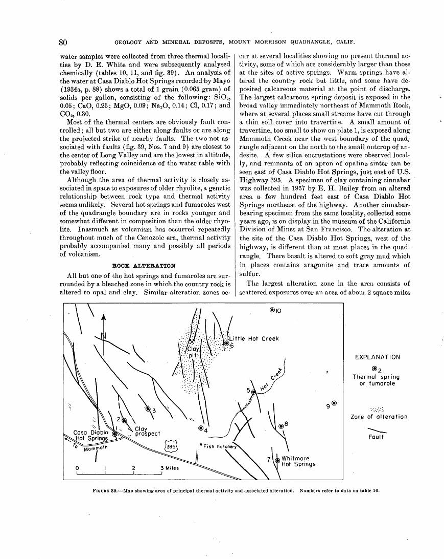
80 GEOLOGY AND MINERAL DEPOSITS, MOUNT MORRISON QUADRANGLE, CALIF.,
water samples were collected from three thermallocalities by D. E. White and were subsequently analysed chemically (tables 10, 11, and fig. 39). An analysis of the water at Casa Dia;blo Hot Springs recorded by Mayo (1934a, p. 88) shows a total of 1 grain (0.065 gram) of solids per gallon, consisting of the following: SiOz, 0.05; CaO, 0.25; MgO, 0.09; Na20, 0.14; Cl, 0.17; and COz, 0.30.
Most of the thermal centers are obviously fault controlled; all but two are either along faults or are along the projected strike of nearby faults. The two not associated with faults (fig. 39, Nos. 7 and 9) are closest to the center of Long Valley and are the lowest in altitude, probably reflecting coincidence of the water table with the valley floor.
Although the area of thermal activity is closely associated in space to exposures of older rhyolite, a genetic relationship between rock type and thermal activity seems unlikely. Several hot springs and fumaroles west of the quadrangle boundary are in rocks younger and somewhat different in composition than the older rhyolite. Inasmuch as volcanism has occurred repeatedly throughout much of the Cenozoic era, thermal activity probably accompanied many and possibly all periods of volcanism.
ROCK ALTERATION
All but one of the hot springs and fumaroles are surrounded by a bleached zone in which the country rock is altered to opal and clay. Similar alteration zones oc-
0 2 3 Miles
cur at several localities showing no present thermal activity, som3 of which are considerably larger than those at the sites of active springs. 'V arm springs have altered the country rock but little, and some have deposited calcareous material at the point of discharge. The largest calcareous spring deposit is exposed in the broad valley immediately northeast of Mammoth Rock, ·where at several places small streams have cut through a thin soil cover into travertine. A small amount of travertine, too small to show on plate 1, is exposed along Mammoth Creek near the west boundary of the quad; rangle adjacent on the north to the small outcrop of andesite. A few silica encrustations were observed locally, and remnants of an apron of opaline sinter can be seen east of Casa Diablo Hot Springs, just east of U.S. Highway 395. A specirnen of clay containing cinnabar was collected in 1!)57 by E. H. Bailey from an altered area a few hundred feet east of Casa Diablo Hot Springs .northeast of the highway. Another cinnabarbearing specimen from the same locality, colle~ted some years ago, is on display in the museuin of the California Division of Mines at San Francisco. The alteration at the site of the Casa Diablo Hot Springs, west of the highway, is different than at most places in the quadrangle. There basalt is altered to soft gray mud which in places contains aragonite and trace amounts of sulft,1r.
The largest alteration zone in the area consists of scattered exposures over an area of about 2 square miles
Hot Creek
EXPLANATION
@2 Thermal spring
or. fumarole
Zone of alteration
~ Fault
FIGURE 39.-Map showing. area of principal thermal activity and associated alteration. Numbers refer to data on table 10.
GEOLOGIC STRUCTURE 81
'l'hormallocallty
I. Casa Diablo I rot Springs.
2. Clay prospect. __ ----
'l'ompora- Dls- Remarks turo (°C) charge
I 46-92 8 34-9a
. 8 90
(gpm)
2 35 A fow steam vents (highest temperature) and a warm marshy area with some pools (lowest temperature); flow barely percoptiQle.
Small bubbling mud pots and steam vents.
3. Funlarolo ____________ ------------ ---------- Steam vent. 4. Hot bubbling pooL__ 1 49-82 ----------
8 81 ----------: ~t~~ -----2-560-4 93 4 5-10
5. Springs along I lot Crook. ·
6. IJittlo Hot Crook. ___ Scalding 1
7. Whitmore Hot (warm) Springs.
8. Worm spring _______ _
2 79
I 38 I 450 ------------ 2 30Q-450
8 59 Hot•
Circular clear pool about 50 ft across, bubbling in center.
Five individual springs and two steam vents along the edge of tho stream.
Several springs at the base or a sandstone hill between two prominent faults.
Site concealed by recent developmont of the springs; water is uRed in a public swimming pool.
Aureole or calcareous tufa.
9. Wnnn spr.lngs _______ ----------------------}Springs or small discharge; tem-IO. Wnrm springs ______ ------------ perature probably below 38° C.
1 Waring (1915). 2 Stearns, Stearns, and Wnrlng (1937). 8 Gom·go Clovoland, California Division of Minos (written communication, 1956). 4 D. K Whl.to (written communication, 1960).
near the clay pit east of Little Antelope Valley. The country rock is chiefly lacustrine sandstone with a subordinate amount of rhyolite breccia. The most comJnon n.ltern,tion product is white kaolinite clay that can be traced in places from thin sea.ms along fractures in the host rock gradn.tionnJly into massive, dense clay that shows no trace a.s to the original nature of the rock. In most outcrops the texture of the sandstone or breccia is preserved, even though the rock is almost wholly a.ltered to clay. Locally, within the altered zone, opal is the chief alteration product, but both opal and clay are typically closely associated. "'Vhere the country rock is extensively opalized the texture of the host rock is commonly destroyed. In a few places, well-bedded unaltered sandstone wn,s tr~teed into an opaJized zone in which bedding is completely obliterated. At several exposures opal and clay appeat.: to have formed selectively in ditrerc.nt. sandstone beds, but clay is generally the more abundant. A specimen of clay from this zone, exn.mined by means of X-ray diffraction, is composed almost entirely of kaolinite, with possibly a small nmount of montm01~illonite or illite.
Three zones of alteration within the quadrangle lie outside the area included on figure 39. One occurs a few hundred yards west of Mammoth Rock where a small test pit exposes loose metavolcanic rock and granodiorite, largely altered to clay. A second, in the valley floor north of Old Mammoth where material was excavated from holes dug fo~ power holes, contains much white clay, suggesting that a considerable amount of clay may exist beneath the present soil cover in this area. Its extent was not determined and it is not shown on plate 1. The third small zone of alteration is west of
TAnLJ<~ ll.-Ghemoical analyses of wate,r, 'i'n 1JWrts lJer 1nillion, ['rom thermal Slwing~S
[Analysts, H. C. Whitehend and J.P. Schuck]
Locality No. (fig. 39) and laboratory No. (in parentheses)
pll_---- --------------------------------------Si 02. ________________________________________ _ Fe ___________________________________________ _ AL __________________________________________ _ Mn __________________________________________ _ Cu __________________________________________ _ Pb __ ----- ___________________________________ _ Zn _______________ : ___________________________ _ Ca ______ ------ _____________________ -~- _______ _
Mg_------------------------------------------Sr ___________________________________________ _ N a __________________________________________ _
K-- ------------------------------------------'l'i
~ifr=.~===:: = = = = = = = = = = = = = = = = = ~ = = = = = = = =: = = = = = = = = = As ___________________________________________ _ C Oa. _______ ----- ____________________________ _
HCOa.- --------------------------------------804-------------------------------------------PO. _____ ------- __ ------ _____________ ----- ____ _ CL __________________________________________ _
F ---------------------------------------------Br _________________________________ ------ ____ _
L--- -----------------------------------------N 03. _________ - _ -- ___________________________ _ N 02 ______ --- _-- _____________________________ _
B ____ - ----------------------------------------IT 2S. _______ ----- ____________________________ _
5 (346)
8. 3 131
. 04
.0
.0
.00
. 00
. 01 4. 4 .2
0 350
20 .0
1.7 .1
LO 7. 9
497 . 90 0. 82
200 10
. 7
.4 0 .00
10 .2
4 (347)
6.1 110
. 04
8 (348)
6.6 118
7. 6 18. . 2 . 5
363 317 22 19
2. 6 2.0
0 0 454 497 107 80
245 11
11
172
. 2 ------------
8. 2
the Arcularius Ranch along the north boundary of the quadrangle where andesite is partly bleached and altered to gray clay.
GEOLOGIC STRUCTURE PRE-CENOZOIC
The strata of the Mount MoiTison roof pendant strike northwest and form a steeply dipping, generally homoclinal stratigraphic section, which is locally folded and faulted. The section is progressively younger from east to west and appears to be a remnant of the eastern limb of a synclinorium whose axis lies west of the, quadrangle and is generally coincident with the axis of the Sierra Nevada .. Structurally the pendant can be divided into two contrasting parts along a line marking the bound~ ary between the Convict Lake and the Bloody Mountain blocks (p. 17 nnd 28 and fig. 2) and the subsequent discussion emphasizes this division.
FQLDS
McGEE MOUNTAIN AND CONVICT LAKE BLOCKS
The only major fold recognized is exposed on the south slope of McGee Mountain where it is conspicuous in a thick light-colored sandstone layer (pl. 1) which curves through an angle of more than 90". The axial plane strikes north and is almost vertical ; the axis is also approximately vertical. The fold is bounded on the east and west by the Hilton Creek and the McGee faults, respectively, and hence is structurally isolated from most of the other units composing the strati-
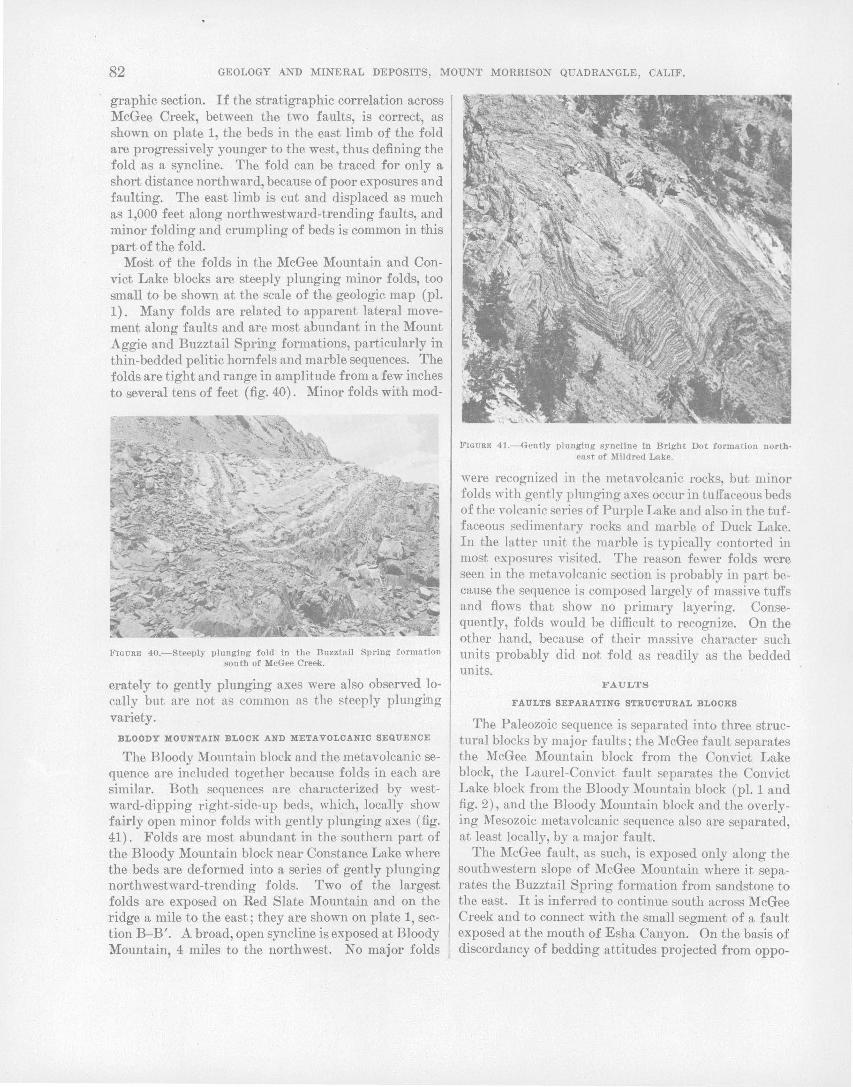
82 GEOLOGY AND MINERAL DEPOSITS, MOUNT MORRISON QUADRANGLE, CALIF.
graphic section. If the stratigraphic correlation across McGee Creek, between the two faults, is correct, as shown on plate 1, the beds in the east limb of the fold are progressively younger to the west, thus defining the fold as a syncline. The fold can be traced for only a short distance northward, because of poor exposures and faulting. The east limb is cut and displaced as much as 1,000 feet along northwestward-trending faults, and minor folding and crumpling of beds is common in this part of the fold.
Most of the folds in the McGee Mountain and Convict Lake blocks are steeply plunging minor folds, too small to be shown at the scale of the geologic map (pl. 1). Many folds are related to apparent lateral movement along faults and are most abundant in the Mount Aggie and Buzztail Spring formations, particularly in thin-bedded pelitic hornfels and marble sequences. The folds are tight and range in amplitude from a few inches to several tens of feet (fig. 40). Minor folds with mod-
FIGURE 40.-Steeply plunging fold in the Buzztall Spring f ormn.tion south of McGee Creek.
erately to gently plunging axes were also observed locally but are not as common as the steeply plunging variety.
BLOODY MOUNTAIN BLOCK AND META VOLCANIC SEQUENCE
The Bloody Mountain block and the metavolcanic sequence are included together because folds in each are similar. Both sequences are characterized by westward-dipping right-side-up beds, which, locally show fairly open minor folds with gently pl\mging axes (fig. 41). Folds are most abundant in the southern part of the Bloody Mountain block near Constance Lake where the beds are deformed into a series of gently plunging northwestward-trending folds. Two of the largest folds are exposed on Red Slate Mountain and on the ridge a mile to the east; they are shown on plate 1, section B-B'. A broad, open syncline is exposed at Bloody Mountain, 4 miles to the northwest. No major folds
FIGURE 41.--Gently plunging syncline in Bright Dot formation northea s t of Mildred Lake.
were recognized in the metavolcanic rocks, but minor folds with gently plunging axes occur in tuffaceous beds of the volcanic series of Purple Lake and also in the tuffaceous sedimentary rocks and marble of Duck Lake. In the latter unit the marble is typically contorted in most exposures visited. The reason fewer folds were seen in the metavolcanic section is probably in part because the sequence is composed largely of massive tuffs and flows that show no primary layering. Consequently, folds would be difficult to recognize. On the other hand, because of their massive character such units probably did not fold as readily as the bedded units.
FAULTS
FAULTS SEPARATING STRUCTURAL BLOCKS
The Paleozoic sequence is separated into three structural blocks by major faults; the McGee fault separates the McGee Mountain block from the Convict Lake block, the Laurel-Convict fault separates the Convict Lake block from the Bloody Mountain block (pl. 1 and fig. 2), and the Bloody Mountain block and the overlying Mesozoic metavolcanic sequence also are separated, at least locally, by a major fault.
The McGee fault, as such, is exposed only along the southwestern slope of McGee Mountain where it separates the Buzztail Spring formation from sandstone to the east. It is inferred to continue south across McGee Creek and to connect with the small segment of a fault exposed at the mouth of Esha Canyon. On the basis of discordancy of bedding attitudes projected from oppo-

GEOLOGIC STJtUCTURE 83
site sides of Esha Canyon, the fault is also inferred to continue south up Esha Canyon and connect with the fault that separates the Buzztail Spring formation fro!ll the siliceous hornfels and marble unit to the east in that area. If the interpretation of the fold at McGee Mountain
as a syncline is correct, stratigraphic continuity would require the presence of an anticline between McGee Mountain and exposures of the Mount Aggie formation to the west. As no evidence for such an anticline was found, it is inferred that the missing beds were cut out along a continuation of the McGee fault; and the fault is therefore projected several miles to the northwest of its northernmost exposure, as shown on the geologic map.
The Laurel-Convict fault extends through the entire length of the pendant from near the mouth of Laurel Creek southward across Convict Creek to Mount Baldwin. It is generally parallel with, and defines the base of, the Bright Dot formation, although it shows crosscutting relations in at least one locality east of Convict Creek (fig. 42). The older rocks east of the fault, however, are discordant along the entire length of the fault; the stratigraphic separation is about 8,900 feet. East of Convict Creek, the contact between the lower sandstone and lower hornfels members of the standstone and hornfels of Sevehah Cliff shows marked drag suggesting left-lateral movement along the fault (pl. 1 and fig. 42).
McGEE MOUNTAIN AND CONVICT LAKE BLOCKS
Pre-Cenozoic faults are more common in the McGee · Mountain and Convict Lake blocks than west of the Laurel-Convict fault. They form a pattern of widely distributed northward- to northwestward-trending steeply dipping fractures that are roughly parallel to regional bedding attitudes but that in places are markedly crosscutting. In addition to the mapped faults, many others less continuous than those shown on the geologic map (pl. 1) are common throughout the two blocks and fit the same regional pattern.
Faults showing considerable displacement can be seen on McGee Mountain, south of Buzztail Spring, and between Mount Aggie and Laurel Mountain. Several faults cut the east limb of the major fold on McGee Mountain, the largest displacement amounting to 1,000 to 1,500 feet in an apparent left-lateral direction. South of Buzztail Spring, a fault showing apparent left-lateral movement of more than a thousand feet displaces the calcareous quartz sandstone member of the Buzztail Spring formation. A major fault extends northwestward from Mount Aggie to Laurel Mountain, where it joins the Laurel-Convict fault. The fault
FIGURE 42.- View southeas t from Laurel Mountain showing the Laurel· Convict fault on the east side of Convict Creek. Bright Dot Lake Is visibl e in t he •middle ground at the extreme right edge of the pho tograph. s, lower sandstone unit of the sandstone and hornfels of Sevehah Cliff ; BD, Bright Dot forma tion. Note the truncation of bedding in Bright Dot formation.
cuts bedding at a steep ·angle along the northern twothirds of its length, but east of Mount Morrison it curves southward and passes into a strike fault. Horizontal separation along the transverse part of the fault is on the order of a half to three-quarters of ~ mile of apparent left-lateral displacement. Unfortunately, most of the faults in the two blocks, both mapped and unmapped, are strike faults that only locally truncate beds and along most of them the sense and amount of displacement could not be measured. Inasmuch as most of the faults in the McGee Mountain and Convict Lake blocks are roughly parallel and the direct.ion of displacement, where determined, is mainly in the same direction, it seems probable that most of the faults are genetically related and relative movement along them was largely in the same direction. Dip-slip movement relative to lateral movement was probably small.
Several of the faults that cut the metamorphic rocks are truncated by granitic rocks and many contain

84 GEOLOGY AND MINERAL DEPOSITS, MOUNT MORRISON QUADRANGLE, CALIF.,
quartz veins or granitic dikes, thus dating them as older than the granitic intrusive rocks. The majority, however, bear no indication of their age relative to the granitic rocks,· but because nearly all are part of the same general pattern they are inferred to be of essentially the same age.
BLOODY MOUNTAIN BLOCK AND ME.TA VOLCANIC SEQUENCE
Only two faults showing fairly large displacements were found in the metamorphic rocks west of the Laurel-Convict fault, one at Mammoth Rock at the north end of the pendant and the other at Red Slate Mountain near the southern quadrangle boundary. At Mammoth Rock a northwestward-trending, steeply dipping normal fault defines the Paleozoic-Mesozoic contact bringing the Mount Baldwin marble into contact with the metavolcanic breccia of Mammoth Rock. The stratigraphic separation is about 4,700 feet and inasmuch as the fault is practically vertical, the southwest side must be downthrown on the ··order of 5,800 feet relative to the northeast side. Intense metamorphism of the m;arble along the fault, as shown by coarse recrystallization and formation of considerable wollastonite, indicates that the fault is pre-Cenozoic in age although it may also have sustained movement du:ving the Cenozoic. Northeast of Red Slate Mountain, 1a northwestward-trending normal fault cuts the east limb of a major anticline and displaces it possibly as much as a few hundred feet- downthrown on the west. Elsewhere in the rocks west of the Laurel-Convict fault, there are few faults, all of which are normal faults that show only minor amounts of displacement-at most not more than a few tens of feet. Although the faults cannot be dated unequivocally as pre-Cenozoic, many contain quartz veins or epidote concentrations indicating that they antedated or were contemporaneous with metamorphism.
SPECULATIONS
Any explanation of the pre-Cenozoic structural features must account for the contrast in structure between the rocks east and west of the Laurel-Convict fault. The principal structural differences in the two groups of rocks are: (1) beds west of the fatllt are right side up and strike about N. 30° W., whereas beds east of the fault are generally overturned and generally strike more nearly north; (2) many of the minor folds east of the fault plunge steeply, whereas those west of the fault generally plunge gently; ( 3) faults occur most commonly east of the Laurel-Convict fault.
It seems unlikely that a single stress system would cnuse such contrasting types of structural features to beds that do not differ markedly in gross lithology; therefore, two periods of deformation may have oc-
curred. Such a suggestion could doubtless be tested if enough P.etailed d~i.ta on the attitudes of minor fold axes were available; but, unfortunate}~, present data,
. are insufficient for this purpose. Evidence previously given (p. 28), however, suggests that the Laurel-Convict fault coincides with an unconformity; hence, the rocks east of the fault might have been deformed before the beds of the fault '"ere deposited. The divergence of fold axes on opposite sides of the Laurel-Convict fault, based upon the little data available, lends support to this conclusion.
The age of the faults showing lateral movement can be determined only within broad limits--most of the movement antedates the granitic intrusives and at least some, as on the Laurel-Convict fault, postdates the Bright Dot formation (fig. 42). Inasmuch as practically all the faults showing apparent lateral displacement occur east of the Laurel-Convict fa.ult, it is tempting to speculate that1 the earliest movement along them was contemporaneous with an earlier period of deformation. The fact that the Laurel-Convict fault postdates the Bright Dot formation, hmYever, opens the possibility that most or all of t:he movement on the major faults is conteniporaneous with or somewhat later than the defonnation which folded the strata west of the Laurel-Convict fault. On these grounds, ~t might be argued that no unconformity exists n..nd that, after a general period of folding and rotation of the entire section tmvard N1e west, forces of a different nature caused the faulting which, for some reason, 'vas localized in the eastern half of the pendant. Dislocation along the Laurel-Convict fault conceivably could account for the discordance in both strike and clip of the beds along the fault. ·
The interpretation favored by the writers is that. the Laurel-Convict fault is a faulted unconformity and that most of the faults to the east had their inception during an early period of deformation-that is, before
·the deposition of the Bright Dot and younger formations. At a later time, probably while or after the Bright Dot and younger rocks were deformed, stresses reactivated the faults established during the earlier deformation and caused lateral movement along th~ unconformity as well.
In order to better visualize structural features that might have been formed during an earlier period of defonnation, the structures as they presently appear were graphically rotated so that the beds of the Bloody Mountain block were in a horizontal position. To do. this a general attitude of N. 30° W. with a westward dip of 65° was assumed :for the beds of the Bloody Mountain block; a north strike and an eastward dip of 70° was assumed for the beds east of the Laurel-Convict

GEOLOGIC STRUCTURE 85
fault. After rotation, the structural features east of the Laurel-Convict fault were orientated as follows: (1) The beds strike slightly east of north and dip west 55°; (2) previously vertical fold axes plunge 20° S. 60° W.; (3) the major fault which joins the Laurel-Convict fault nea.r Laurel Mountain strikes almost east-west and dips south 55° where it cuts the beds at the steepest angle; ( 4) the displacement along this fault is oblique slip, plunging 44o· S. 55° E., assuming that the present apparent strike-slip displacement represents the net slip. As a. result of graphic restoration, it appears that the faults showing left-lateral movement become practically normn.l fault's with a large dip-slip component of movement and the presently steep fold axes become gently plunging-attitudes and movements which would not be inconsistent with structures that might have formed during an early period of defonna.tion.
The question of the relative amounts of displacement before and after deposition of the Bright Dot and younger fortnations cannot be answered for the faults east of the Laurel-Convict fault; but as indicated by the drag along the Laurel-Convict fault, the· post-Bright Dot m.ovement on that fault is at least several hundred feet and possibly as much as a few thousand feet.
The more intensely deformed part of the Mount Morrison pendant, east of the Laurel-Convict fault, a:buts against a blunt salient of the Rock Creek mass of the Round Valley Peak grm1odiorite, which shows evidence of having been forcibly emplaced at other localities (p. 50). Forcible northward expansion of this pluton might account, in part, for the intense deformation east of the Laurel-Convict fault.
CENOZOIC
The area included in the discussion of Cenozoic structure extends about 6 miles east, and 2 miles north of the Mount Morrison quadrangle in order to include the entire Long Valley basin (pl. 4). The basin also extends 3 miles west of the quadrangle, but this segment was not mapped and is not included on plate 4. The Long VaJ1ey basin .is a well-defined structural unit and includes most of the Cenozoic structures mapped in the· area. For these reasons the basin as a whole is discussed rather than only the part that lies within the Mount Morrison quadrangle.
The Long Valley basin is a convex northward-trending crescent-shaped graben that is 10 mile$ wide and more than 17 miles long; it is bounded on the north and south by escarpments ranging in height from 2,000 to more than 4,000 feet. The margin of the basin is lowest near Lake Crowley where the terrain stands only a few hundred feet above the floor of the basin. In addition to the boundary faults, numerous high-angle, north- to
northwestward-trending normal faults cut the volcanic rocks that occupy the .west-centr~l part of the basin, and broad warps were detected along the east margil). and near Long Valley Dam.
A GRAVITY srruDY OF LONG VALLEY
By L. 0. P A KISER
A gravity survey of the Long Valley basin was completed by a U.S. Geological Survey party during 3 weeks of fieldwork in the summer of 1955 as part of a regional geophysical study of the Owens Valley area (Pakiser and Kane, 1956). A total of 257 gravity stations ·(including four base stations) was established in the Mount Morrison and Casa Diablo Mountain 15-minute quadrangles and immediately adjoining areas. The base stations in th~ Long Valley ar~a were carefully tied to the base station at Bishop that had been established by the Geological Survey in 1954. Several gravity stations from the 1954 survey in northern Owens Valley were reoccupied during the fieldwork in Long Valley, and satisfactory ties were obtained. AII·gravity base stations in Long Valley and Owens Valley were tied to the U.S. Coast and Geodetic Survey pendulum station near Independence (Duerksen, 1949, p. 180).
FIELD METHODS AND REDUCTION OF GRAVITY READINGS
A Worden gravity meter with a sensitivity of about 0.5 milligal per scale division was used ~o make the survey. Gravity stations were run in single loops from an initial reading at a base station. Base readings were .repeated at intervals of 4 hours or less to determine the drift and tidal variations of the instrument. In each loop at least one station from a previous loop was read to check on the overall accuracy of the gravity data ; a station withineach loop was repeated as a check on the uniformity·of the instrument drift between base repeat· readings. No repeated gravity reading differed from the initial reading by more than 0.25 milligal. Elevation a11d position control for the gravity stations was obtained from Geological Survey topographic maps and bench-mark data, supplemented by plane-table and alidade surveying. Errors of vertical closure of 3 feet in the valley and 10 feet on the mountain slopes were permitted. Errors of horizontal closure did not exceed 500 feet. Thus the permissible errors of closure for the gravity readings and the equivalent errors of closure for the survey co11trol (expressed in units of gravity) were about the same.
Corrections of elevation and.latitude were computed using standard methods (Nettleton, 1940, p. 51:--56). A combined free-air and Bouguer elevation correction factor of 0.060 milligal per foot ~as used, corresponding to a density of 2.67 g per cm3
, the average density of the
86 GEOLOGY AND. MINERAL DEPOSITS, MOUNT MORRISON QUADRANGLE, CALIF.
crystalline rocks in which the greatest variations in elevation are found. Corrections for latitude were determined from the tables of theoretical gravity on the International Ellipsoid (:Nettleton, 1940, p. 137-143). Corrections for terrain through zone "0" were made using the Bullard modification of the Hayford-Bowie method (Swick, 1942, p. 67-68). (The outer radius of zone "0" is about 100 miles.) All gravity values were reduced to the absolute complete Bougu~r gravity in milligals plus 1,000 so that only positive figures would appear on the gravity map and profile. The absolute complete -Bouguer gravity in milligals can, therefore, bereadily obtained by subtracting 1,000.
Finally, the gravity field was contoured on a base map with a scale of 1 :62,500 using a contour interval of 1 milligal. In plate 4 this gravity contour map is reproduced at a smaller scale and with a contour interval of 5 milligals. All interpretations presented later, however, were based on profiles constructed from the original gravity contour map.
INTERPRETATION OF THE GRAVIrrY DATA
The clastic and volcanic deposits of Cenozoic age that fill the Long Valley basin· have a much lower average density than the crystalline rocks that form the surrounding mountain masses. The gravity field (corrected for elevation, latitude, and terrain) in the valley area should therefore be lower than that in the surrounding mountain slopes and other areas where crystalline rocks· crop out or are near the surface. By a careful study of the corrected gravity field at least qualitative conclusions can be reached on the subsurface configuration of the buried pre-Cenozoic bedrock floor. If the density contrast between the valley fill and the pre-Cenozoic bedrock is known or can be estimated or if some control is available from drill-hole or seismic information, the depth and attitude of the buried preCenozoic bedrock can be determined fairly accurately along selected profiles. From the subsurface information thus determined, it is possible to draw some conclusions on the nature of the geologic events that led to the present physiography and subsurface structure.
The average density contrast between the valley ,fill and the buried crystalline rocks is not known accurately. It is assumed to range between 0.3 and 0.7 g per cm3
• It is extremely unlikely, however, that the density contrast could be. as small as 0.3 or as great as 0.7 g per cm.3 and 0.5 is taken as the most probable density contrast. All theoretical interpretations in this study are based on these limiting and most probable assumed density contrasts. All depths. presented were computed using a density contrast of 0.5 g per emS, but the actual depth to pre-Cenozoic bedrock may possibly range between roughly 70 and 170 percent of the esti-
mated depths. No direct evidence is available to support these density assumptions, but they are known to agree with those of oil companies doing gravity work in the Great Basin. Seismic evidence obta:ined in a Geological Survey study of Searles Lake (Mabey, 1956) supports a density contrast. there of 0.65 g per cm3 between the basin fill and the bedrock. The Pleistocene muds that fill much of the Searles Lake. basin are probably considerably less dense than the Cenozoic clastic and volcanic rocks that predominate in Long Valley.
In this study, the interpretation of the gravity data has been approached in the following order:
1. A qualitative study \vas made of the gravity contour map (pl. 4) to reach broad, general conclusions on the nature of the subsurface configuration of the preCenozoic rocks.
2. Selected profiles were analyzed using 'the theoretical formula for a semi-infinite horizontal sheet, which closely represents a vertical fault (Nettleton, 1940, p. 111-112) ~
3. The subsurface structure of the valley block was redescribed on the basis of the quantitative information obtained from the detailed analyses above.
4. Some conclusions were reached on the nature of the geologic events that led to sub~idence of the valley block, erosion of the mountain masses, and deposition of the thick section of the valley fill.
The gravity field sho,vn by the gravity contour map is assumed to be. a true representation of the gravity field on the surface of the ground, corrected for elevation, latitude, and terrain effects. This assumption is believed to be valid over most of the area, but where large local changes in elevation occur in materials of lower density than that assumed for the. elevation cor-
. rections (2.67 g per cm3) the relative gravity held may
be slightly higher than that shown on the map. The general shape and amplitude of the anomalies, however, is reliable. The assumption that the subsurface masses analyzed .are semi-infinite horizonta-l sheets is of co:urse not literally· true, but the errors that result from this assumption are not great. Because of the uncertainties concerning densities, no further refinements are considered to be worthwhile, but, if anything, the error in this assumption results in computed depths that are so mew hat less than true depths.
GRAVITY CONTOUlt l\lAP
The local g~avity relief in the Long Valley area is the largest yet found (1959) in the Great Basin by a U.S. Geological Survey party. In magnitude it rivals the great gravity minimum anomalies found in the basins between the Coast Ranges of California, in which tens of thousands of feet of sediments of Tertiary age ac-

GEOLOGIC STRUCTURE 87
cumulated. The maximum gravity relief is about 75 milligals between the low in Long Valley and the high in the Benton Range ( 4 iniles east of the map along profile A-A'), a distance of only 13 miles. A gentle regional decrease i.n gravity toward the west is an expression of the isostatic compensation of the high mountain masses ( mainly the Sierra Nevada) of the region (Oliver~ 1956).
The most noticeable gravity feature shown on the map is the elliptical low in the Long Valley basin. This gravity low indicates that many thousands of feet of clastic and volcanic rocks of Cenozoic age have accmnulated in the basin. It is surrounded by steep gravity gradients, suggesting that the bedrock everywhere slopes steeply into the valley from the surrounding mountain masses. The gravity gradients are notably less steep along the Sierra Nevada front, however, than they are northeast of Lake Crow ley and south of Glnss Mountain. The extren1ely steep gravity gradients on the east side of Long Valley are in general well removed westwnrd from any physiographic escarp-
. ments. The gravity map of the Long Valley area is surpris
ingly simple in appearance. It suggests that the Long Valley basin is a structural basin that has been dropped downward along vertical or high-angle normal faults on all sides. There are, however, a number of local features of interest. The northward-trending Hilton Creek fault is flanked by a muTow gravity low caused by the accumulation of detrital materials between the crystalline rocks west of the fault and those exposed less than a mile to the east. This gravity low is superimposed on the steeper gravity gradients of the Long Valley block nnd extends to the north well out into Long Valley. Just south of Lake Crowley, a similar gravity low trends northward into Long Valley parallel to the Hilton Creek fault. The southern part of this low correlates in part with exposures of detrital materials and the Bishop tuff. The axis of the -low trends along the Sierra Nevada escarpri1ent. . A pronounced gravity low of several milligals relief
is expressed along the gorge of Owens River, east of Lake Crowley. This low may' represent a section of several hundred feet of Bishop tuff (average density, about 1.9 g per cm3
) that fills a topographic depression, perhaps the ancestral drainage course of Owens River. The surface upon which the Bishop tuff was deposited · consists of dense volcanic, metamorphic, and plutonic rocks.
Near the center of the Long Valley basin, a pronounced gravity high of unknown origin is revealed by the single line of gravity stations that crosses it. The high coincides in part with rhyolite outcrops in the
vicinity of Little Antelope Valley and with a series of northward· trending normal faults that have displaced the exposed rhyolite. This gravity high could represent a mass of dense rock within the pre-Cenozoic rocks below, a structural or topographic high on .the bedrock surface, or a mass of igneous rock within the valley fill.
The gravity low at the extreme southeast corner of the map continues southeastward into Round Valley and thence into Owens Valley.
ANALYSIS OF GRAVITY ANOMALIES
One gravity profile (A-A') was analyzed in detail, and estimates of the depth of the valley fill along the· fault system bounding the Long Valley basin were made at four other localities (B, C, D, and E).
Along profile A-A' (pl. 4) the total gravity relief shown is nearly 70 milliga]s; the gravity field continues to rise off the profile to the east until the total relief is about 75 milligals. The steepest gradient along this anomaly is about 20 milligals per mile. The depth of the valley fill irrimediately to the west of the steepest gradient was estimated to be about 11,000 feet from the formula for the gravity attraction of a semi-infinite horizontal sheet. When the computed gravity anomaly for a thick semi-infinite sheet was matched to the actual gravity anomaly, a postulated vm;tical fault separating 12,090 feet of Cenozoic clastic and volcanic rocks from the crystalline rocks to the east was· found to yield an almost perfect fit, assuming that the average density of the valley fill is 2.2 g per em 3 and that of the bedrock is 2.7 g per cm3
• This fault, as shown on plate 4, is here named the Long Valley fault zone.
The computed gravity anomaly has a maximum gradient that is somewhat steeper than that of the actual gravity anomaly. This difference in steepness could mean that the fault is not vertical but dips very steeply to the west. The difference could mean, however, that the density contrast between the Cenozoic and preCenozoic rocks is less than the 0.5 g per cm3 assumed and that the depth of valley fill against the fault is greater than 12,000 feet or that fairly thick lighter material covers the buried fault trace. Several combinations of depth, dip, and density contrast could be used to obtain a good match of computed and actual gravity anomalies, but none could differ greatly from that adopted and still be geologically reasonable. Because of these ainbiguities, which are inherent in any gravity interpretation where other control is lacking, no effort was made to refine further the quantitative interpretation of the anomaly. Although the depth of the valley fill against t)le fault may differ considerably from 12,000 feet, the interpretation shown is nevertheless considered to be the most probable one.
88 GEOLOGY AND MINERAL DEPO~ITS, MOUNT MORRISON QUADRANGLE, CALIF ..
The geologic c'ross section determined from the analysis of the gravity anomaly is shown on plate 4 with the surface relief' and geology along profile A -A'. It is seen that the great fault has no present physiographic expression along the profile. As this· idealized geologic section shows, the pre-Cenozoic floor of Long Valley lies, at an altitude of about 5,000 feet below sea level just west of the fault.
The depth of the valley fill in fault contact with the crystalline rocks was computed from the formula for a semi-:i:nfinite sheet along_ the steep gradients at loca.li.,. ties B, C, D, and E (pl. 4) and was found to.be about ·3,500, 3,500, 8,000, and 5,500 feet, respectively. These computed depths are not certain, especially because the complete anomaly at these locations is not as well defined as that along profile A -A'.
DISCUSSION OF INTERPRETATION
Long Valley is a structural basin, bounded by verti-.cal or steeply dipping normal faults and filled to a probable depth of about 12,000 feet with clastic and volcanic rocks of Cenozoic age. A continuous fault or n~rrow fault zone surrounds the Long ·valley basin. Bec-~use a great thickness of valley fill is in fault contaxt ·with pre-Cenozoic rocks throughout the Long Valley .fa;ult .~one, there has probably been prolonged continuous or repeatedly rejuvenated movement along the fault as the LOng Valley basin subsided._ Subsidence of .the valley block and deposition of the valley fill ~ere ·presumably simultaneous processes; the valley fill was faulted soon after its deposition and displaced against the bedrock. The bedrock floor must hava subsided thousands of feet to reach an elevation as much as '5,000 fe~t below sea le~el (pl. 4). The depth of the valley fill imm'ediately west of the Long Valley fault zone is not unifortil but increases from a minimum along the Sierra Nevada front near the western border of the. Mount Morrison quadrangle to a. maximum along the eastern boundary of the Long Valley basin. The depth probably increases most sharply in the interval between the intersection of the. Long Valley fault zone and the Hilton Creek fault (near location C) and where the Long. Valley fault zone crosses profile A -A'. This increase in depth suggests that the bedrock floor of the basin tilted downward to the east and north as it subsided. The floor is probably not a piane surface; rather it is probably warped or faulted in such a way that it is concave upward mainly as a result of drag along the fault" zone and possibly in part by the weight of the great load ·of deposits that was piled on it.
The position of the Long-Valley fault zone as shown on the. combined gravity and geologic map· (pl. 4) is considered to be generally reliable within about a quarter of a mile, except' where it swings sharply to the
west from its northward trend several miles north of· Lake Crowley, and also just to the east of its intersection with the Hilton Creek fault. The throw along the fault zone din1ini~hes to the west along the Sie.rra Nevada front.
The Long Valley fault zone describes a large, nearly circular arc along ti1e eastern boundary of Long Valley. Southward from a point west of Watterson Troughs, there is no physiographic expression of the fault zone and no recent fault scarps were recognized. It is concluded, therefore, that the Long Valley fault zone in this locality has been quiescent for some time. The fa~lt has been completely concealed by the erosion of the crystalline rocks to the east and the removal and transport of the derived clastic sediments westward where they were deposited over the fault. The quiescent period must have been preceded by a prolonged period of subsidence.
South and east of the Long Valley fault zone the local ·gravity anomaiies suggest the geReral configuration of an old erosion surface of plutonic, metamorphic, ~and volcanic rocks upon which the Bishop tuff and some detrital materials were deposited. In addition, these local gravity anomalies may reflect the accumulation of valley fill against northwestward- to northward-trending faults whose displacements are minor as compared with that of the Long Valley fault zone. The ancestral .drainage course of Owens River, buried under the Bishop tuff, seems to be revealed by a gravity low which. trends generally along the present Owens River gorge. The old valley of Owens River may have: been broader }:lere and-·much more mature than the present youthful gorge.
·No signiP,eant. gravity low separates the Sierra Nevada from the large· block of plutonic and metamorphic rocks that includes th~ Benton Range, 4 miles east of the area included. on plate 4. These mountain masses 'are· not separated completely by a structural basin, but subsidence has .take.n place on both .sides. of their con ... necting ridge. In a sense, the large ·block east of Long Valley; which may be designated the Benton block, is a spur of the Sierra Nevada block. . .
There are some local gravity anomalies north of the southern ·arc of the Long. Valley fault zone even though the pre-Cenozoic bedrock is several thousands of feet deep in this area. It is suggested that.·.these.local anomalies are the e~pression of ne::t.r-surface, density contrasts, perhaps revealing faults that have displaced 'a dense layer of volcanic rocks against lighter clastic. sediments or pyroclastic rocks. . .
The pronoun~ed gravity high in th~. center of the · Long V al~ey basin prob~bly reflects, in part, ~a volcanic neck that may have been the source of the volcanic rocks in this area and, in part~ buried flow rocks. However,

GEOLOGIC STRUCTURE 89
the high may be, in part, the expression of a bedrock high that resulted from the downwarping or downfaulting of Long Valley in t.wo part.s to the west and east of it.
Finally, there may be another fault in addition to those shown on the map and previously described. This fault is suggested by the more detailed gravity map~ and it lies along the 740-milligal contour, where it is nearly a str'aight line southwest of the high in the center of the basin. · Movement along this suggested fault would have been down to the north. ·
ORIGIN OF LONG VALLEY
Long Valley has been an area of complex volcanic activity as well ·as profound structural deformation. The volcanism of .the l4>ng Valley area has been described by Gilbert ( 1938, 1941) and i~ is discussed elsewhere in this report (p. 52-64). Gilbert recognized the possibility that the "recent faulting· in. Long Valley is the result of the extrusion of so much magma from beneath that area * * *." Chelikowsky ( 1940) also called attention to this possibility. In this respect, the Long Valley block seems to have many of the characteristics of subsidence caldera or perhaps a vol~anotectonic depression as described by Will~ams ( 1941). Some intimate relationship propably exists .between Cenozoic volcanism and the subsidence of the ~Long Valley hlock, but it is not probable tha~. ~xtrusioJl of magma from beneath Long Valley·w~s the sole ca~1s~_of fault moveme11t. The stresses that ca~1sed the faulting of the ranges of the area probably also .. contributed to the origin of the Long Valley basin. · .
A simple calculation shows that appr?.ximately 200 cubic miles of rocks with a probable average density of 2.2 g per em 3 have. been deposited within the bounding fault system of the.Long Valley basin. If it is assu~~d that the faults of this system are nearly vertical, an4 that little or no warping. or distributive faulting has occurred in the uplift of the surrounding mounta~~ masses, an upper limit of about 250 cubic miles of rocks could have been removed since uplift by erosion from tlie mountah1 inasses that delimit the present Long Valley drain~ge b~sin. The actual volume of rock eroded was undoubtedly less than this, but it is clear
amount may be large, but the above estimates ·of volumes of rock eroded from the mountain masses suggest that stream erosion played an important role in the origin of the rocks that fill the Long Valley block. Many of these rocks were probably deposited as lake beds. No reliable estimate of the total volume of volcanic rocks that may have been ':withdrawn from beneath Long Valley is possible, but the Bishop tuff alone probably has a volume of 35 cub'ic miles or more (Gilbert, 1938) . Volcanic activity was probably continuous during the subsidence of the Long Valley block which, in the writer's opinion, began with the extrusion of the early Pliocene ( ~) flows in the area (Gilbert, 1941).
The mechanism of origin postulated is that a magma chamber existed below Long Valley and that the Long Valley block subsided along a vertical or nearly-ver~ica] system of bounding faults as support was removed by the extrusion of magma from the chamber. It is assumed that the total pressure exerted on the confining rocks by the volatile components of the magma was less than the load of the overlying rocks (for example, about 2,500 bars for a depth of burial of 10 km). Initially, the load of the overlying rocks and the strength of the rocks were enough to confine the magma within the chamber. But, when either the confining pressure was reduced (perhaps by application of a uniaxial tensile stress) or the internal pressure of the magma was increased (for example, by increasing the water content), the vapor pressure forced the upward migration of magma along some of the faults or fractures and extr.usion of lava, followed by withdrawal of support and subsidence of the valley ~lock.
Extrusion of lava stopped when the es.cape of volatile components reduced the vapor pressure, subsidence halted, and the system came tq rest. A new increase in vapor pressure and perhaps a· rejuvenation of faulting caused the process to be repeated. Kennedy ( 1955) has suggested a mechanism that could result in an increase in the partial pressure of water. The area is r:toW quiescent, except for a few hot springs, and p:r:esuina~ly it has been quiescent for some time, as (widericed by the. lack of physiographic expression of several of the great faults' bounding 'Long Valley.
that much of the material composing the valley fill had FAULTs
its source' in the surrounding uplands. Most of the faults were mapped on the basis of their Many of the rocks removed from the mountain masses physiographic expression, as seen 011 aerial photo-
by erosion were pre-Cenozoic plutonic and metamorphic h h' h . t h' fl f f t d d ff rocks (mainly in the Sierra'Nevada), but sorrie material grap ~' w Ic cons~s s .c Ie Y 0 · ace e ~purs an ° -of volcanic o'rigin ·was removed·; mainly from Glass : se~ bedrock and alluvial surfaces; no~ ere were exMountain. This could repr~s~nt material that was orig.: I posed fault. surfaces seen. Sev~ral sprmgs along ~he inally extruded from a magma chamber beneath Long base of the ranges at both the north and south margms Valley. Some~Jight.pyr~las.tic rocks·and heavi~r flow II ~fthe basin coi~cide with the physiogr~phic traces of rocks must also be buried In Long Valley,- and· the the range-bounding faults, and other spnngs and zones
90 GEOLOGY AND MINERAL DEPOSITS, MOUNT MORRISON QUADRANGLE, CALIF.
of thermal alteration occur along several faults that cut the volcanic rocks.
At only two places in the area was a datum available from which the throw along the faults could be meas..: ured. Near Wilfred Canyon along the northeast marO"in of the basin an andesite flow is downthrown on the b
west for a minimum vertical distance of 150 feet. Im-mediately north of Little Antelope Valley, at the head of the canyon cut by Little Hot Creek, a fault that cuts lacustrine sandstone may have vertically displaced the sandstone 250 feet or more. The sandstone is downthrown on the west and exposures both east and west of the scarp dip ·20° to 30° W.; this evidence suggests· drag along the fault. Individual beds were not mapped in the sandstone, but if the uppermost surface of the sandstone on both sides of the fault is correlative, the throw would be about 250 feet. Moreover, the highest part of the rhyolite hill to the east is abundantly strewn with well-rounded pebbles of rhyolite suggesting that
· lacustrine beds once covered the hill. If this is true, the throw on the fault may be as much as 350 feet. Along other mapped faults in the area, the throw is estimated from the height of the scarps, which are generally a few hundred feet high in the volcanic terrane but are thousands of feet high along the margin of the basin.
The escarpments along both the Bald ~ountain-Glass Mountain and Sierra Nevada fronts were formed as a result of faulting, although both are somewhat eroded. Both escarpments are comparable in height and in steepness, the Bald Mountain-Glass Mountain ~scarpm'ent ranging in height from 2,000 to 4,000 feet and the Sierra Nevada escarpment ranging from 2,000 to 4,500 feet. Both escarpments diminish somewhat in height westward, but the northern escarpment, where it curves south to form the east margin of the basin, diminishes in height also southward, decreasing from a height of nearly 4,000 feet near ·Glass Mountain to about 800 feet near Watterson Troughs, 7 miles to the southeast. ·The northern escarpment is remarkably regular, curving northwestward, north of Wilfred Canyon to O'Harrel Canyon, where it becomes due '\vest. The southern escarpment shows virtually the same trend, extending northwest from Rock Creek to McGee Mountain and thence west to the western boundary of the Mount Morrison quadrangle. The southern·escarpment is the more irregular of the two, partly because of the greater dissection of the Sierra Nevada front due to more abundant precipitation and partly because of the more irregular pattern of the range-bounding faults.
The elliptical fault zone interpreted from gravity data and shown on plate 4 parallels the escarpments that enclose the Long Valley basin, but it is typically located toward the center of the basin several thousands
of feet from the escarpment. The position of the zone relative to the escarpments and the slopes of the escarpments (the steepest slopes are less than 40°) indicate that the original fault scarps have been deeply eroded. No evidence of recent movement was detected along the zone at the north and northeast margins of the basin; therefore, faulting has probably not occurred there for some time. The mapped faults in this area are apparently subsidiary to the main zone as defined by gravity data, although considerable movement may have occurred along some of the faults, particularly the frontal· fault southwest of Glass Mountain.
Along the south margin of the basin, the fault zone interpreted from gravity data coincides with several mapped faults; this evidence indicates that movement in this area has occurred along the major fault zone more recently than it has along the zone at the north and east margins. The mapped faults along the Sierra Nevada front show very little physiographic expression and are typically marked by springs and minor offsets of morainal features. The oldest moraine cut by a ·frontal fault is northeast of Convict Lake and is probably pre-: Tahoe in age. Assuming the movement along the entire eastward-trending segment of the Sierra Nevada front has been comparable in magnitude, probably less than 25 feet of displacement has occurred along this ~egment of the front since middle Pleistocene time.
The greatest displacement of pre-Cenozoic bedrock, according to the interpretation of gravity data, occurs along the Long Valley fault zone at the east margin of the basin; but in contrast to the margins of the basin elsewhere, no physiographic escarpment is associated with it. Indeed the average slope of the terrain east of the fault zone is less than 3 o. The fault zone in this area parallels and lies immediately west of dissected lake terraces in an area covered by valley fill. There has apparently been no movement along the fault zone in this area for a considerable time, as suggested by the complete absence of scarps or other evidences of faulting. North of Long Valley Dam, however, a normal fault
·striking N. 35° E. delimits the main mass of Bishop tuff on the northwest and is parallel with the Long Valley fault zone. Throw along this fault is about 200 feet, down thrown on the west; the fault post-dates the deposition of the Bishop tuff but apparently predates the adjacent lacustrine deposits, which are not cut by the_ fault. The space relationship between the tuff-bounding fault and the Long Valley fault zone is similar to the relationship between the zone and the mapped faults that bound the basin on. the north and northeast. This suggests that the mapped faults are subsidiary to the Long Valley fault zone and .are probably within the main zone of dislocation.
GEOLOGIC STRUCTURE 91
The faults that cut the volcanic rocks in the westcentral part of the basin are composed of three groups: an eastern group and a western group which strike N. 10° E. toN. 10° W. and are typically downthrown on the east and an intervening group which strikes N. 20°-400 W. and is typically downthrown on the west. The scarps range in height frmn a few "tens of feet to more than 500 feet. The eastern northward-trending group lies on the projected strike of the Hilton Creek fault, but as indicafud by the gravity contour map, the preCenozoic bedrock is displaced only a little northwest of Whitmore Hot Springs. The gravity high, defined by the closed 740-milligal contour near Little Antelope Valley, may nevertheless be an expression of displacement of unknown magnitude in the pre-Cenozoic bedrock floor along a northward extension of the Hilton Creek fault. Besides creating a series of sharply defined topographic ridges, the three· groups of faults appear to have also controlled the broad topographic configuration of the area. Progressively from west to east across the faulted area the general slope is eastward across the two groups of faults that are chiefly downthrown on the east and westward across the group that is chiefly down thrown on the west.
The fault west of Mammoth Lakes, shown at the extreme west edge of plates 1 and 4, is a feature which has received considerable local publicity and is known as the "Mammoth earthquake fault." The fault is visible discontinuously over part of its length as a fissure about 7 feet wide and 60 or more feet deep, in flow-b~nded quartz latite. It is marked by a shallow trench in pumice-covered terrain along much of its length. Benioff and Gutenberg ( 1939) described the fault as one of a group of related features which ~ccur in an area of about 10 square miles, ~ainly ~n, the Devils Postpile quadrangle adjacent on the west. From detailed measurements they state that the eiast side, .was elevated 11h feet and moved .northward 11;2 feet relative to the west side. They corichided tentatively that the fissure is a tectonic feature rather than a superficial crack developed in cooling laVJa. The present writers agree that the fissure is tectonic in origin, chiefly because it fits well with a local group of northward-trending faults, most which are 'in the area immediately adjacent ·on the west. Furthermore the rock cut by .the fissure is of probable Tertiary •age, hence it is unlikely that as a qooling crack it would have survived the Pleistocene without having been filled with detritus. Ther~ is no historical support, for an· earthquake origin ,for the fault; the name was probably attached beoause of the similarity. in appearance to ear~hquake-formed fissures.
6~9-993 0-64-7 •
WARPS
·Along the eastern and southeast margins of Long Valley, ·lake terraces and the Bishop tuff are warped. The easternmost limit of the terraces along the east .margin.of the valley presumably marks the highest lev-el attained by ancient Long Valley lake and is interpreted as a remnant of the uppermost shoreline. The · altitude of this horizon at Long Valley Dam is 7,000 feet, and it increases uniformly northward to 1a maximum of about 7,900 feet at Wilfred Canyon. This increase demonstrates at least 900 feet of deformation since the impounding of Long Valley lake. About 31h miles east of Long Valley Dam, the Bishop tuff appears to have been upwarped relative to its position at Long Valley Dam. There the surface of the tuff is about 400 feet higher than the easternmost lake terrace near the dam. The principal assumption on which the 'interpretation of ~his warp depends is that the layers in the tuff-hence the· surface into which lake terraces were cut-were originally horizontal.or sloped gently southward. From the Long Valley Dam eastward for about 3 miles, however, layers in the tuff, as exposed in the Owens River Gorge, dip perceptib~y west, locally as much as 5o. The surface of the tuff in this area also slopes westward, ht~t is much less regu~ lar than the layers. In addition, the profile of Owens River from the south. boundary of the Casa · Diablo Mountain quadrangle northwestward to th~ Long Valley J~am is markedly ·9~nvex upward (Rinehart and Ross, 1957). These features all suggest that _the tuff has been warped, and, as suggested by the convex pro'file· of Owens River, warping may indeed be active at the present time.
AGE OF THE DEFORMATION
The. oldest faults that cut the ~ocks of Cenozoic ~ge are probably · those that define the boundaries of the Long Valley basin. Evidence in one. locality along- the 'Sierra N·evada fr~mt suggests that much of the· uplift of the range to its present height or:curred after earliest Pleistocene glaciation. The evidence is derived from the boulder deposits atop McGee Mountain which, the writers believe; were correctly interpreted by Blackwelder ( 1931) as representii~g· till of the oldest known (McGee) glacial stage in the S ieiTa Nevada. The till rests at a maxi:r;num altitude of 10,700 feet on: a rollii~g northwa:rd-slopl.ng upland sur~ face and is derived, ii1 part,· from granitic rocks .exposed to the south along the upper course of McGee Creek. . S.ince th~ till was deposited, McGee Creek has
' cut a canyon 2,500 feet deep between the source· area and the, present site of the till; this evidence suggests th~t the cany.on. was·cut in respo~1se to uplift after the
92 GEOLOGY AND MINERAL DEPOSITS, MOUNT MORRISON QUADRANGLE, CALIF.
earliest glaciation. Inasmuch as the range front shows a similar degree of erosion along the entire segment included on plate 4 and has rise~ along ~elated faults, it seems probable that the major displacement along all the frontal faults occurred after early Pleistocene. Moreover, the greatest displacement apparently took place before the two youngest glacial advances, for, at the point of emergence from the range front, most streams are nearl)'i 2,000 feet below the crest of the escarpment and have cut only a short distance into the underlying till.
The faults that delimit the basin on the north cannot be dated with assurance, although displacement on the order of 2,000 feet or more occurred after the extrusion of the andesite and rhyolite of Pliocene(~) age. The escarpment is considerably less dissected than the Sierra Nevada escarpment, but this is probably due to the small amount of precipitation-hence erosion-in the Glass Mountain-Bald Mountain area. Inasmuch as both the Sierra Nevada and the Glass MountainBald Mountain escarpments were created by down faulting of the Long Valley basin, are comparable in height, and show parallel trends, it seems reasonable to conclude that they formed at about the same time by nearly synchronous movements along the boundary faults. The movement that formed the existing escarpments began after earli~st Pleistocene and was nearly complete before late Pleistocene.
In the light of the interpretation of gravity data, however, the basin as a structural unit must have ex-
-isted long ·before the present bounding escarpments. This conclusion hinges upon the correlation of the andesite and rhyolite in the west-central part of the basin, with the andesite and rhyolite in the Glass Mountain area (p~ 63-64). Near Gl1ass Mountain, andesite and rhyolite, as much as 3,'000 feet thick, rest on pre-Cenozoic bedrock, but in the west-central part of the basin the base is not exposed. Section A-A' (pl. 4), inferred from gravity data, shows the pre-Cenozoic bedrock floor 12,000 feet below the surface at A, which is about a mile northeast of an outcrop of rhyolite. Consequently the thickness of the volcanic units required at A would have to total about 12,000 feet, or almost four ·times the thickness exposed :Iiear Glass Mountain, if the ·volcanic units rests on pre-Cenozoic bedrock. Such a thickness. ~eems improbable, and it is conchided that the Long Valley basin existed prior to the displacemenf of the andesite and rhyolite near Glass Mountain and that the correlative andesite and rhyolite in the westcentral part of the basin rest on detrital material deposited in a preexisting basin.
Movement on the faults that cut the volcanic rocks is probably largely contemporaneous with that along the faults marginal to the basin. Faults near Little
Antelope Valley show vertical displacement of 150 feet and possibly as much as 3fi0 feet since the deposition of the· lacustrine sandstone in middle Pleistocene time. This evidence suggests that if the movement along all the faults in the volcanic terrane was essentially contemporaneous and if the maximum displacement is 500 to 700 feet, probably about half the total displacement along them occurred after middle Pleistocene time. Post-Pleistocene movement is shown along some of the faults but is most conspicuous along the Hilton Creek fault, which displaces Recent alluvium and young (Tioga~) moraine at the mouth of McGee Creek Canyon (fig. 35).
MINERAL DEPOSITS
The mineral deposits that have been exploited in the quadrangle are contact metamorphic tungsten deposits, disseminated and quartz-vein deposits of gold and silver, clay deposits formed by the thermal alteration of rhyolitic rocks, "ornamental stone" (flow banded rhyolite), pumice, and sand and gravel. In 1955 only tungsten and clay were bei.ng mined. · Lead, zinc, and copper were recovered in small
amounts as by-products of the gold-silver mining operation, and molybdenum is recovered in small amounts from the milling of the tungsten ore. Minor deposit~ of lead, zinc, copper, uranium, calcite· ("Iceland spar") and barite are scattered throughout the southern half (Y'
the quadrangle and most have been prospected.
METALLI:C DEPOSITS
TUNGSr.I'EN
All the tungsten deposits in the quadrangle are contact metamorphic and contain scheelite ( Ca W04) as the only tungsten-bearing mineral. The scheelite occurs as disseminated grains, generally less than a millimeter in diameter, in tactite that has formed by metamorphism of calcareous rocks, chiefly limestone, along contacts with granitic rocks. Tactite, as first defined by Hess ( 1919), is "a rock of more or less complex mineralogy formed by the contact metamorphism of limestone, dolomite, or other soluble rocks into which foreign matter from the intruding magma has been introduced by hot solutions or gases." The tactite in the Mount Morrison quadrangle consists of grossulariteandradite garnet, diopside-hedenbergite pyro:xene, and epidote as the chief constituents and varied but smaller amounts of hornblende, quartz, and calcite. Scheelite, commonly associated with powellite, molybdenite, pyrite, and pyrrhotite, is sporadically disseminated in the tactite; gold and bismuthinite occur locally in tactite at the Scheelore mine. Tactite has formed in the calcareous rocks along and near contacts with most of the major intrusive rocks, but the most productive deposits
...
MINERIAL DEPOSITS 93
of scheelite-bearing tactite are west of Hilton Creek along the contact between the Wheeler Crest quartz monzonite and the Hilton Creek marble. In addition to· the major deposits shown on plate 1, scheelite-bearing tactite occurs at three other locaJities: ( 1) ·a specimen collected from the metavolc~nic terrane about half a mile south of Lee Lake, south o:f the quadrangle boundary, contains traces of sc~e~lit~ in a thin garnethornblende-quartz veinlet; . (2) scheeJite-.bearing tactite is also reported on the west. s~qe qf Nevahbe Ridge near the head of Esha CanyQn (;fimm-ie.Ni~oll, Bishop, Calif., ot:al communication;· 1955.), presumably. where calcareous units of the Mount Aggi~ formation· are· in contact with granodiorite; ( 3) tactit~ f9rms a layer as much as 6 feet thick in a calcar~01.1s quartz. sa:ndstone unit -in the Mount Aggie forma~io~~~ al;>Out half a mile south of Horsetail Falls, along the gr,appdiorite-.contact. Although specimens collected by the writeJ?s "::ere .ll~rren, scheelite is reported from this locality by H. A. Van Loon of Bishop (oral communication, 1955).
The total tungsten production from. th~ quadra~gle to the end of 1955 ~as somewhat more than_12,000 units (1 unit equals 20 pounds of WOs.) .,;,
. : . WHEELER CREST QUARTZ MONZONITE
NICOLL HILTON CREEK MINE
.. The Nicoll Hilton Creek mine, owned by D. H. Nicoll, of Bishop, Calif., is located at the east base of N evahbe Ridge in the canyon of Hilton Creek. The workings are at an altitude of 9,700 to 9,850 feet and can be reached by a priva~e road from U.S. Highway 395. The mine is snowbound for 4 to 6 months of the year, but the property could be kept open through the winter, although. this has not .been done in the past. .The deposit was first exploited sometime after 1940, and the total production to the end of 1954 was about 7,000 tons of ore containing about 1 percent of WOs, ~tc~ording to R. B. Schwerin, the p:r:esent operator (1955).
The workings consist of a crosscut driven about 200 feet on a general westward heading, an opencut about 100 by 60 feet with a small underground room at one end, a.nd a raise from the .crosscut to the floor of the pit (pl7. 5). Since the mine was mapped in August 1954, the adit has been extended a short distance northward along the contact between· the quartz monzonite and the tactite ... About 1,000 feet south of the adit, exposures of scheelite-bearing tactite have been prospected at the surface.
The deposit is localized in a re-entrant along the northward-trending contact between the Wheeler Crest quartz monzonite and the Hilton Creek marble. In the mine area th~ metamorphic-rocks project eastward into the quartz monzonite, so that in plan view the .ore body is surrounded on three sides by the intrusive rock. Also,
the strike of the marble, which is generally·concordant with the northward-trending contact, bends in toward the re-entrant and is markedly discordant. The easternmost end of the marble salient is almost wholly converted to.tactite. These relationships suggest that the peculiar configuration of the contact has been a contributing factor in the localization of the ore. The large mass of diorite that occupies part of the re-entrant in the granitic contact along with the tactite is probably the result of contamination of the graniticrock by metamorphic materi~l.
The tactite consists chiefly of red-brown grossulariteandradite garnet (Gr6o-7o) and green diopside-hedenbergite pyroxene ( Di4o-'55), with lesse.r amounts of darkgreen hornblende, quartz, and calcite.· Small crystals of scheelite, ranging in size. from.pin points to 2 or 3 II1Irl in diameter, are. disseminated through the tactite. Some of the scheelite . occurs in "streaks" formed by tabular concentrations of tiny scheelite crystals. In most specimens the streaks . are parallel to indistinct mi:n,eral layers that may reflect original b~dding. The ~re ·also p,optains ··small amounts of molybdeni~~ .~n~ its al~er~tion ':l:?r~duct, powellite. . .. • , .. • ' • o ' " ~ I
-.... PHELPS HJLTON CREEK MINE .•
..
The Phelps Hiltbri' Creek min~, owned by R. ~· Phelps of Bishop, Calif., is ab~ut 2,500 feet south of the Nicoll Hilton Creek mine ~Llong the same quartz monzonite contact. The workings range in altitude from 9,900 to 10,000 feet. The mine is accessible from U.S. Highway 395 by 'inmins of a private road, 5 miles long, that was built in 1939. In the fall of 1939 a.nd the summer of 1940, ·the Bishop Tungsten Co., as lessee, shipped 553 tons of ore from which about 350 units of WOs were recovered. Production from 1941 to the end of 1955 totaled about 6,000 tons of ore averaging about 0.6 percent WOs (3,600 units), according to G. B. Hartley, the present lessee (1955). The workings COJ?.Sist of two opencuts-:-one about 180 by 15 to 30 feet and another about 90 by 50 feet, a winze, and a 65-foot crosscut from which a raise to the surface was driven (pl. 6).
Scheelite-bearing tactite occurs in two bodies along a segment of the contact between the Wheeler· Crest quartz monzonite and marble interbeds of the siliceous hornfels unit that overlies the Hilton . Creek marble fartHer north. The contact in general strikes N. 20° W. and is nearly vertical. The beds are concordant. in strike but dip gently to steeply westward away from the contact. The ore body is locaiized in a large reentrant in the quartz monzonite contact (pl., 1), similar in some respects to the ore hody at the Nicoll mine but showing 'concordant ~ather than discordant rela.2 tions. The· concordancy is reflected·. in the formatio~ of tactite par~llel to the granitic··· contact ·in ··:Co:ritrast
94 GEOLOGY AND MINERAL DEPOSITS, MOUNT MORRISON QUADRANGLE, CALIF.
to the discordant relatio~s of the tactite at the Nicoll mine.
Most of the production has come from the southernmost tactite body, which measures ·135 by 25 feet in plan and is developed by means of the elongate opencut. Although the tactite body generally parallels bedding in the marble, its shape is irregular in detail, as shown by the unreplaced marble remnants along the west side of the· opencut and by reconstruction of the original outcrop (pl. 6, section A-A'). based on information supplied by G. B. Hartley and L.A. Wright (written communication, 1954). The tactite is similar in composition to that at the Nicoll mine, except that it contains more quartz, particularly along the quartz monzonite contact. The scheelite is typically fine . grained, but no information is .available concerning its distribution within the tactite. The ore contains small amounts of molybdenite locally.
TIPTOP PROSPECT
within the tactite mass locally show laminations, which also probably reflect bedding.
Scheelite is concentrated in linear zones, a few feet thick, that strike eastward or northeastward and are neady normal to the trend of the granitic contact and to bedding. Small postmineralization faults and mafic and felsic dikes cut the tactite and are oriented in about the same direction. No structures are visible along the scheelite-ooaring zones, but their general parallelism to the dikes strongly suggests that they were controlled by the fracture system along which the dikes were intruded. If this is true, the fractures probably existed early in the formation of the tactite but were eventually obliterated by the replacement process during metamorphism. The dikes may have been intruded somewhat later as indicated by the fact that the quartz monzonite. was solidified enough to sustain fractures along which the dikes were intruded. .
FILIPELLI PROSPECT
The Tiptop prospect, owned by R. W. Phelps of The Filipelli prospect is located about 1,00Q feet north Bishop, Calif., is located on McGee Mountain in the of the large pit at the Nicoll Hilton Creek mine and is SE%, sec. 19, T. 4 S., R. 29 E., at an altitude of about accessible from it by road. A minor amount of surface 9,800 feet. The prospect was ·accessible in 1955 by exploration was done during the summer of 1955, but no jeep or pickup truck from a private road that intersects ore was shipped and the grade is not known. U.S. Highway.395 at the M;cGee Creek highway main- . The geologic setting of the·Filipelli prospect is sometenance station, east of Tobacco Flat, and traverses up~· what similar to that of the Nicoll mine although on a the north face of McGee Mountain. A small tonnage smaller scale. A tongue of contorted Hilton Creek marof high-grade scheelite-bearing tactite ore was pro- ble extends eastward into the Wheeler Crest quartz duced from the property between 1940 and 19~2, but monzonite and is in part replaced by tactite. The tacsince then the property has been idle except tor as- tite. consists chiefly of dark-green pyroxene and redsessment work. Workings consist of a 20-foot shaft · brown garnet, with lesser amounts of hornblende, and 5 small trenches totaling about 200 feet in length quartz, calcite, and epidote, and occurs as small irregu( fig. 4?) · larly shaped masses at several places along the contact.
The prospect is along a somewhat irregular north- Fine-grained scheelite is dissemimited locally in the ward-trending co.ntact between the Wheeler Crest tactite. Granitic rock exposed near the base of the face quartz monzonite and calcareous rocks (pl. 1) which .of a small pit beneath marble and tactite· suggests that have been converted· to tactite. The contact is gen- the deposit j.s probably very small. · · · erally concordant along the central part of the tactite · .. ~ Q~~"" mass but is discordant at both the north and SOUth ends. ~· PRO~PEcfT ON THE SOUTHEAST SLOPE OF MCGEE MOUNTAIN
.The tactite. mass is exposed over a width of 60 to 80 A prospect on the southeast slope of McGee Mountain feet for 460 feet along the contact, and an isolated out- in the NEl~ sec. 32, T. 4 S., R. 29 E., at an altitude of crop northwest of the large mass suggests that the small 8 800 feet is accessible by a private road that intersects OU:tcrop .may connect with the large mass beneath the ti1e McGee Creek road, about a mile· south of U.S. Highslope wash.: The tactite consists chiefly of dark-colored way 395. Tactite forms thin layers parallel to beddin~ diopsid~-:hedenbergite pyroxene and grossularite-andra- in a dominantly marble unit near a dike of contamidite garnet (Grso, determined from specific gravity and nated granitic rock. Although the tactite was presum_. optical data), with quartz an'd calcite; fine-grained ably prospected for tungsten, several grab samples rescheelite· is locally concentrated ·in thin zones within vealed ho scheelite when examined in ultraviolet light. the tJactite. Miner~l layers in the tactite probably re- A short adit driven about 100 feet below the tactite outfleet beQ.ding, for. they are generally parallel to well- crop, presumably for the· purpose of intersecting the defined bedding in the rocks exposed a short distance tactite at depth, is the only working; marble is the only to the south. : 'fhin .. layers of siliceous calc-hornfels rock exposed in the adit, however.

'l
0 50
APPROXIMATE MEAN
DECLINATION, 1963
100
CONTOUR INTERVAL 10 FEET DATUM IS APPROXIMATE MEAN SEA LEVEL
150 FEET
MINERAL DEPOSITS
Simplified from map by L.A. Wright (written communication, 1953)
FIGURE 43~-Geologtc map of the Tiptop prospect.
EXPLANATION
.~ ~ Slope wash
Tactite Includes minor siliceous cole-hornfels
layers. Stippling shows scheelitebeoring zone
Felsic dike
Mafic dike
Wheeler Crest quartz monzonite
Argillaceous hornfels and slate
Metachert
Ill Marble
Contact Dashed where probable
Fault 70 90
..L. +-Strike and dip of layering,
presumably bedding
~ Open cut
>-
H ::> 0
Vl ::> 0 LLJ u ~ LLJ a: u
z c(
u > 0 c a: 0
95
96 GEOLOGY AND MINERAL DEPOSITS, MOUNT MORRISON QUADRANGLE, CALIF •.
LEE LAKE MASS OF THE ROUND VALLEY PEAK GRANODIORITE
HARD POINT PROSPECT .
The Hard Point prospect is located in sec. 29, T. 4 S., R. 28 E., on the north face o_f Bloody Mountain at an · altitude of 10,800 feet. The property has been known since the early 1930's and possibly earlier. It was described by Mayo (1934a) who erroneously referred to its location as the "southern slope of Bloody Mountain." At present the claims are held by Frank H. Watkins and J. F. Birchim of Bishop, Calif., and in 1955 the property was leased to J. H. Lucas of the Hard Point Mining Co. A road to the property, which branches from the Laurel Creek Jeep Trail, was completed in the summer of 1955, but no ore was shipped and· no work was done on the property during 1956.
The prospect is near the base of a nearly vertical cliff about 500 feet high along a nearly horizontal concordant contact between the Bloody Mountain formation and the Round V all~y Peak granodiorite. The mineralized rock is in the core of an' open syncline that plunges gently southward. A sulfide-rich zone, 10 to 15 feet thick and parallel to bedding, is exposed along the cont~ct for approximately 350 feet. The zone shows no internal structure and consists of pyrite, pyrrhotite, and chalcopyrite, disseminated in a pyroxene-quartz hornfels matrix. Small amounts of scheelite, powellite, and molybdenite occur sporadically in the zone. Pods of tactite., locally contai11-ing scheelite and molybdenite, occur sporadically about 50 feet above the contact in calcareous layers. The only way to reach the tactitebearing layers is by means of a ladder and ropes anchored to pipes driven into drill holes in the cliff face; because of the limited access little is known of the lithologic character and distribution of the pods and the continuity of the mineralized beds. The molybdenite- and scheelite-bearing tactite pods consist chiefly of garnet and pyroxene; with some disseminated scheelite and molybdenite extensively altered to powellite; a few specimens exceptionally rich in molybdenite were found. Cobbles and boulders of granodiorite containing disseminated molybdenite were found in the talus near the base of the cliff. Sample data supplied by F. H. Watkins show high percentages of gold, copper, tungsten, and molybdenum, but unfortunately the widths and lengths of the samples are not known.
MORHARDT PROSPECT
The Morhardt prospect is in.·a pile of huge glacial boulders just south of Laurel Lakes at the mouth of the large cirque in which the Hard Point prospect is located. The property was worked in the late' 1940's but nothing has been done sine~ that time. The boulders contain much tactite that presumably was carried by
glaciers from the outcrop at the Hard Poinfl prospect. The owner, J. E. Morhardt of Bishop, Calif., estimates that a hundred tons of ore averaging about 1 percent WOa were mined. He also states that assays of as much as 5 percent molybdenum were common.
PAPPAS PROSPECT
The Pappas prospect is located a mile west of Sherwin Lakes on tJhe lower slope of the range front at an altitude of 8,800 feet. The property was located in 1951 by Nick Pappas of Bishop, Oalif., who subsequently· constructed a road which connects the property with a secondary road leading to the Sherwin Lakes trail. The property has been explored by bulldozer trenching, but no work was done during 1955 and 1956.
The prospect is in an outlier of Mount Baldwin marble near a contact with the Round Valley Peak granodiorite. -No rock in place is exposed at the prospect, although the trenches are locally as deep as 15 feet. Scheelite-bearing tactite occurs as pods in large angular boulders of marble uncovered in some of the trenches and also as fragmen~s in the slope wash, some occurring as much as 100 feet up the hill south of the southernmost trench. The tactite is composed chiefly of red-brown garnet and dark-green pyro.xene, with lesser amounts of quartz, calcite, and, locally, scheelite. T'he occurrence of mineralized rock in the slope wash above, or south of, the southernmost trench indicates that future exploration should proceed in this direction.
ROCK CREEK MASS OF THE ROUND VALLEY PEAK
GRANODIORITE_
SCHEELQRE MINE
The deposits at the Scheelore mine are located in a cirque about half a mile south of Mount Baldwin at altitudes that range from 11,000 to 11,600 feet. A 10-mile road suitable for travel by jeep or truck connects the property with U.S. Highway 395. Most of the road follows McGee Creek and is usually blocked hy snow from November ulltil late June. The data on the Scheelore mine in the following discussion are taken from Bateman (1951).
H i8tory and production.-The ore bodies in the mine area were discovered in the fall of 1940 by J. E. Morhardt and H. A. Van Loon of Bishop, Calif. The first work on the property began in the summer of 1942 when a small plant was built to recover scheelite from talus shed by outcrops of scheelite-bearing tactite. The only significant production occurre-d from 1942 to 1944 when about 800 units of WOa were recovered by direct con-centration of scheelite from the fines in the talus. A larger mill was built in 1944, after the completion of an access road by the Public Roads Administrat~on, but no
MINERAL DEPOSITS 97
crushing equipment was installed and the mill was never used. Later, about 200 tons was mined from the tactite outcrops; but because it was milled elsewhere, the assay results are not known. In October 1950 the property was optioned to the Black Rock Mining Corp., a subsidiary of the Wah Chang Trading Co., who sampled the outcrops extensively and, with financial assistance :from· the Defense Minerals Exploration Administration, drilled with a diamond drill four exploratory holes totaling about 1,000 feet in length to test the downward extension of two of the tactite bodies. No scheelitebeu.ring tactite was :found in the drilling and further exporation was abandoned. The last work at the property was done during the summer of 1954 when lessees shipped several truckloads of tactite to the Pine Creek mill of the Union Carbide Nuclear Co. near Bishop.
Geology.-Tactite has :formed in the Mount Baldwin m-arble alo11g a some~ hat irregular northward-trending contact between the Round Valley Peak granodiorite on the east and metasedimentary rocks on the west (pl. 7). The contact dips steeply and, although nearly parallel in strike to bedding of the metamorphic rocks, is markedly discordant in detail, and many apophysal dikes of granodiorite penetrate the metamorphic rocks. In the southern part of the map area the metamorphic rocks form the east limb of an open anticline, the axis of which lies several hundred yards to the west; the beds dip gently to steeply toward the granodiorite. Iri th~ northern part of the area the beds along the grano.:. diorite contact are highly contorted. A large talus apron covers the granodiorite contact in the central part of the map area. South of the tactite ~mtcrops, a wedge of the Mildred Lake hornfels lies between the granodiorite and the Mount Baldwin marble, and no tactite has been :formed. The siliceous hornfels that occurs in the extreme northern part of the area is part of the Bright Dot formation. .
The tactite occurs in :four distinct masses designated on plate 7 as tactite masses 1, 2, 3, and 4. Masses 1, 2, and 3 are in ~he south -central part of the ar~a and mass 4 occurs at the extreme north. The mineral content of the tactitb is varied but consists chiefly of grossulariteandradite garnet (specific gravity, 3.75; n, 1.815; Gr5oAnuo), diopside-hedenbergite pyroxene, epidote, quartz, and calcite. Pyrite, hematite, sphene, and idaerase are commonly present in small amounts. Finegrained scheelite is sporadically disseminated in all the masses, and areas containing 0.4 percent or more W03
are shown on plate 7. A little :free gold and bismuthinite occur locally in mass 4, and a small amount was recovered in connection with gravity concentration of scheelite. This mass also appears to contain more pyrite and pyrrhotite than the other masses, and oxidation of
these minerals has stained the outcrop a bright red brown.
Of all the tactite masses, Nos. 1 and 2. were the most extensively sampled. A total of 86 samples, representing a total width of 1,130 :feet, averaged less than 0.25 percent W03 • Seventeen samples from the southern part of mass 4, representing ari aggregate width of 250 feet, averaged 0.26 percent W03 • Sample data are not available from mass 3, but examination in ultraviolet light reveals material of grade estimated to be similar to that of the sampled bodies. Of the total103 .samples
. collected at the property only two contained as much as 1 percent WOa.
To test the depth, extent, and grade of tactite masses 1 and 2, a total of four holes, inclined at 30 degrees and averaging 250 feet in length, were drilled from two stations, and all but one (D, pl. 7) intersect tactite at about 150 feet below the surface. Core from the fourth hole is entirely marble, suggesting that both masses 2 and 3 at this locality, as well as the dike of granodiorite, dip westward at moderate angles. The tactite bodies in the other borings are at least as thick as the masses exposed at the surface, and none are scheelitebearing. All the bodies are discordant and dip more steeply than the host marble, suggesting that the bodies enclosed by marble were controlled by structures such a_s . joints or small :faults. The granitic contact intersected by the boring in mass 1 dips steeply westward and the associated tactite body is parallel to it.
Of the two scheelite-bearing debris masses in the northern part of the area, the southernmost contains material of better grade. Samples from the pit contained as much as 0.7 percent WOa, although elsewh~re the material is of lower grade. No assay data are avail-
. able from the northern mass, but panning indicates that sclieelite is only about half as abundant as in the south-ern mass.
GOLD AND SILVER
All the p~oductive gold and silver deposits in the quadrangle are within an altered zone 21;2 miles long and half a mile wide in the metamorphosed latite of Arrowhead Lake (pl. 1). The altered zone contains much disseminated pyrite, much of which has oxidized and has stained the entire zone bright reddish brown producing a marked contrast to· the surrounding gray unaltered .rocks. Most of the zone has been explored by means of pits and trenches, but. the mining has been chiefly concentrated e~st and northeast of Lake Mary near the north end of the metavolcanic belt.
Data on the occurrence and composition .of the ore, . as well as the description of the mine workings, are from rep~rts by··· Tucker (1927) and Sampson and Tucker ( 194:0), ~mpplement~q w her~ possible with qata
98 GEOLOGY AND MINERAL DEPOSITS, MOUNT MORRISON QUADRANGLE, CALIF.
obtained by the writers, as all the workings in ore were inaccessible in 1954. The ore is reported to occur in steeply dipping veins a few feet to a few tens ?f feet thick, which strike northeastward and northwestward. Barren vein-quartz crops out on top .of the ridge and small veinlets are common in the accessible workings, but gold and silve·r ore shipped from one prospect consisted entirely of altered metamorphosed latite.
The common mineral assemblage of the ore is auriferous pyrite, free gold, pyrrhotite, arsenopyrite, sphalerite, and chalcopyrite. The gangue consists mainly of quartz and green silicate minerals identified by Mayo ( 1934a) as diopside, actinolite, and epidote. The only information available on the grade of the ore was obtained during the brief productive period 1939-1941 when the ore ran al'?out a third to half an ounce of gold and 9 ounces of silver per ton.
HISTORY AND PRODUCTION
Gold was first produced in the M~ammoth district about 1878. Most of the production between 1878 and the mid-1880's probably came from the Mammoth mine. According to local reports the population in the area was 3,000 to 5,000 in 1879, but after an unusually severe winter during 1879-80, which apparently coincided with the depletion of mrany of the 'ore bodies, it diminished rapidly and regained only a small fraction of its former size during the years following. Some work was done at the Mammoth and Monte Cristo mines in the late 1890's and during a short period preceding World War II. During the summers of 1954 and 1955, more than 200 tons shipped from the B~auregard pros .. pect south of the Mammoth mine reportedly contained profitable concentrations of both gold and silver. Min:. ing continued through 1958, but production data are not available.
The only production figures recorded for the period 1878 to 1881. sho~ that the Mammoth mine yielded $200,000 in gold (Sampson and Tucker, 1940). Additional production in the district. for this period probably amounted to a few hundred thousand dollars. Data on later· production are scant; the Mammoth mine produced 250 ounces of gold and 136 ounces . of silver from 1896 to 1897 and 39 ounGes of gold and 1~214 ounces of silver from 1939 to 1941. Most of the silver was produced in 1941 together with 4,768 pounds of copper and 28,388 pounds of le'ad .. Also during'the period. 1939-41 the Monte Cristo mine yielded 1,153 ounces of gold and 18,6D6 ounce~ ~f silver that totaled $53,000 in: value, . ·The .total production from the district probably did no~ exceed $1 million.
·.MAMMOTH MINE ·
The Mammoth mine is on the north slope of the metavolcanic ridge immediately south of ~he Old ~am~
moth road. In 1940 the mine area included 26 claims, but the original holdings apparently consisted of 5 claims only. In 1955, the owner was J. F. Birchim of Bishop, Calif.
The property ~s developed chiefly by four adits, each more than. 1,500 feet long, driven southeast from the
·north side of the ridge. All are caved shut at the portals. An 87-foot crosscut, driven southwest 465 feet from the portal of the lower adit, is reported to be entirely in quartz. A permanent stream now flows out through the debris-covered portal of the lower adit and furnishes the water supply for several summer cabins in the Old Mammoth area. After World War II the American Metals Co. drove an additional adit eastward for about 500 feet from ra point northwest of the Beauregard prospect immediately west of the quad~ rangle boundary. About 400 feet from the portal, a breccia zone was explored by short ({rosscuts, and some core drilling was done from the face, but apparently nothing was found to stimulate further development and the mine was closed in 1956.
The ore apparently occurs in steeply dipping northwestward-trending veins composed of quartz and decomposed metalatite. Old mine reports state that the ore was 14 to 40 feet thick. Tucker ( 1927) reports the mineralogic composition of the ore to be magnetite, auriferous pyrite, chalcopyrite, sphalerite, and native gold. He further reports that ore from one of the largest stopes yielded $9.00 per ton in gold.
MONTE CRISTO MINE
The Monte Cristo mine was developed after 1927 and consists of three patented claims, the Montecello, Monte Cristo, and Headlight, all located on the west side of the prominent ridge about half a mile south of the l\fammoth mine. In 1955, the owner was W. R. Cowan of Palm Springs, Calif.
A 1,530-foot crosscut, driven northeast at an altitude of about 9,150 feet, was accessible in 1954 and was mapped by the writers. At 1,435 feet from the portal, a steeply dipping shear zone was explored by means of drifts for about 100 feet on each side of the crosscut. · A few feet southwest of the drift, a vertical raise was driven, which, according to the company, penetrated 10 feet of ore 150 feet above the level; the raise is caved at abou~ 50 feet above the level. The ore mined in 1939 to 194i probably came from this raise. Two additional
; 20-foot exploratory raises were driven on shear zones and· quartz stringers. The chief purpose of the crosscut was apparently to provide a main haulage level, and mapping revealed only m-inor structural features con-
. sisting of several small shears with a few inches of associated gouge, minor breccia zones, and anastomosing quartz veinlets, all striking westward to northwestward
MINERAL DEPOSITS 99
and dipping steeply. The crosscut is entirely in metamorphosed latite; which contains some local lenses and stringers of epidote~garnet tactite.
MAMMOTH CONSOLIDATED MINE
The Mammoth Consolidated property comprises· 27 claims, whose main workings are about half a mile south of the Monte Cristo mine. Ore was first discovered in the mine area in 1918 by D. F. Shively of Mammoth. The Mammoth Consolidated mine was originally part of the Mammoth mine holdings, but was optioned in 1927 and is now ( 1955) controlled by the· Mammoth Consolidated Co., of Mammoth Lakes, whose president is A. G. Mahan Jr. ·
The workings, accessible in 1954 and mapped by the , writers, consist of two adits at altitudes of 9,100 and 9,200 feet that are connected by a vertical raise. The lower adit was driven northeast as a crosscut for 70 feet, then southeast as a drift along a nearly vertical zone of anastomosing quartz and calcite stringers. At 280 feet from the portal, an exploratory crosscut was driven eastward for 375 feet but failed to expose any ore-bearing structural features. A vertical raise connecting with the upper adit was driven at a point 300 feet ~rom the portal. The upper adit parallels the lower level as a crosscut for 60 feet, where it intersects the same zone of quartz and calcite stringers exposed in the lower level. The adit turns northwestward and follows the zone of stringers for 175 feet. Although the northwest segment of the adit was reportedly in ore along most of its length, the only stope is at the southeast~rnmost exposure of the zone of stringers, where ore was mined 20 feet along and about 20 feet above the drift. The zone of stringers strikes about N. 60° W. and .. consists of as much as 1.0 feet of anastomosing quartz and calcite stringers and brecciated slivers of metamorphosed latite. It shows a prominent pinch-andswell character. The ore reportedly consists of pyrite (presumably auriferous), pyrrhotite, sphalerite, and some chalcopyrite.
The workings accessible in 1954 are -apparently only a small part of the mine, and Mayo (1934a), who had access to company n~aps, writes concerning the vein system:
Maps which Mr. A. G. Mahan, Jr., kindly permitted the writer to examine, show four principal vein. systems, of which the major set (the North and Mother veins) trend almost parallel to the strike of the wall rock, or about N. 20° ·w. to 30° W. One important vein (the E'ootwall) strikes about 15° farther westward. Branching off from these main fissures are a number of shorter ones that trend about 30° farther westwa.rd than do the North and Mother veins. In addition, the fourth vein set strikes almost E.-W., and appears to cross all of the others. According to Mahan, most of the veins dip about 85° NE., toward the granite, which lies less than one-half mile distant, and has doubtless been the source of the gold-bearing solutions.
Mayo further states that the average assays of some of the veins show values of about $12 per ton in gold over a width of 6 feet.
OTHER .MINES
Because the mines are ·old and adequate published information is lacking, few data are available regarding the other gold-silver mines and prospects near the larger mines just described. l\r[ost are reported to be quartz-vein deposits, although little vein-quartz was seen by the writers in an examination of the surface of the area. The a vail able data are summarized in the following table. Information on all but the Beauregard prospect, which was being worked intermittently during the writers' work in the -area, is largely taken from reports by Tucker (1927) and Sampson and Tucker (1940), witJh minor additions by the writers.
BASE METALS
Small ·deposits of lead,· zinc, copper, and uranium are scattered throughout the metamorphic terrane; most of them were prospected .in the past by means of small pits or short adits, and production, if any, has been minor. A small amount of cinnabar is reported from the Casa Diablo Hot Springs area. by Sampson and Tucker (1940). All the known production of copper
Su.mmary of small gold-silver deposits
Name Location in relation to Mam- Workings moth Consolidated mine
Lisbon 1 _______ 2,000 ft east-southeaSt.------ Three adits of unknown length. Argosy 1 _______ Half a mile southeast on Drifts 150 ft, crosscuts 125 ft _
Mammoth Creek. Sierra •-------- West and northwest_ _______ Drifts 235 ft, crosscut 400 ft,
shaft 80 ft, small opencut.
Beauregard_-- 1,000 ft south ________________ Small opencut..·------------
t Precise location uncertain; not shown Qll plate 1. • Six claims. a No veins; massive altered metamorphosed latite.
Thickness (feet)
2-6
6-8
4
-·---·------
Attitude Mineralogy Production and grade of veins
N. 30° E,, Free gold· and auriferous 70° SE. pyrite,
--------- ... ---- Argentite, pyrite, sphaler- Maximum of 17 oz silver per ton. ite, native silver,
......................................... Pyrite, arsenopyrite, 4 ft $4.00 per ton gold. Small shipment barite in pit. in 1940 by A. E. Beauregard,
Bishop, Calif. (3) Auriferous(?) pyrite _________ Good values in gold and silver re-
ported by C. Beauregard, 220 tons shipped in 1954 and 1955.
100 GEOLOGY AND MINERAL DEPOSITS, 'MOUNT MORRISON QUADRANGLE, CALIF.
and lead in the quadrangle was recovered from goldsilver ore taken from the Mammoth mine.
One of the largest prospects is in the Mount Baldwin marble northeast of Laurel Lakes where two small drifts, a winze, and a small opencut expose a steeply dipping vein that strikes·N. 40° W. and contains sphalerite, chalcopyrite, and pyrrhotite.. According to Mayo (1934a), selected samples of the ore contain as much as 20 percent zinc and 5 ounces of silver per ton.
Small pits have been dug in a 2-foot thick gossan that crops out at the northernmost exposure of the contact between the Mount Baldwin marble and the Bright Dot formation. · No sulfides are exposed, but examination of the material by X-ray diffraction indicates a rather high cerussite content.
URANiUM
A rather unusual type of radioactive deposit occurs in loose rock debris on the Emerald group of claims west of Cold Water Creek near Emerald Lake. In 195·6 the prospect was owned and operated by the Nevada-Goldfield Consolidated Mines Co., Reno, Nev. The first work on the property began in 1955 and consisted of trenching with bulldozer and drag line; in the fall of 1956, a trench about 50 feet long, .15 r'eet wide, and a maximum of 15 feet deep had been excavated. No shipments from the property had been made by 1956, but a representative of the company, A. F. Messmore, reports that samples tested show ~he ore. to be of marketable grade. A bin was constructed near Casa Diablo Hot Springs in which the ore·, almost entirely fine-grained material, was stored.
The trench is at the margin of a boulder field consisting of angular blocks of dark-colored metavolcanic ( andesitic) rocks, many of which are 20 to 30 feet
. across. Many of the boulders are layered and their orientation appears to be haphazard. Near the base of the cut, the material beneath the enormous boulders is compo~ed of an unsorted aggregate of angular blocks, a few inches to 1 or 2 feet in maximum dimension, which are distributed through a matrix of fine- to medium-grained sand and silt. Within this material are local zones which contain appreciable amounts of radioactive minerals, much o:fwhich is probably uranophane. Besides the radioactive zones in fine-grained material, many angular blocks, generally less than a foot across, were also found to be highly radioactive, chiefly as the result of networks of tiny veinlets of uranophane distributed throughout the rock. One specimen contained a o-rain of pitchblende about 2 mm in diameter surround:d by a halo of bright-yellow uranophane.
The material in which the deposit occurs is probably either glacial till or the remnant of a talus apron. The
talus apron appears to be a more likely source, owing to the marked angularity of the blocks and an absence of faceted pebbles or cobbles. The southwest margin of the .boulder field is less than half a mile from the base of the Mammoth Crest escarpment, but ·f}: well-formed rock glacier occupies the intervening distance and has obliterated most of the talus of which the boulder field is probably a remnant. Neither of the two suggested modes of origin for the debris affords an obvious explanation for the localization of the uranium deposit. It is possible, however, that material from a uraniumbearing outcrop in the Mammoth Crest escarpment accumulated at the base of a former talus at the site of the present. deposit. The deposit appears to be small, and one or two mineralized boulders comparable in size to those surrounding the deposit conceivably could have supplied the material.
NONMETALLIC DEP9SITS
CLAY
Two kaolinite clay deposits occur in the volcanic terrane· north of the Sierra Nevada escarpment, the largest near Little Antelope Valley and a smaller deposit half a mile northeast of Casa Diablo Hot Springs. Both deposits were formed as a result of hydrothermal alteration of the country rock, which is chiefly lacustrine sandstone at the Little Antelope Valley deposit and flow banded rhyolite at the deposit near Casa Diablo Hot Springs.
LITTLE ANTELOPE VALLEY
The largest clay deposit in the quadrangle is immediately northeast of Little Antelope Valley at an altitude of about 7,300 feet. In 1956 the deposit was owned by 'Veldon Bathrick and Mr. Wickham of the Imperial Land and Gravel Co. and was under Iease to W. H . Huntley of Bishop, Calif. Development on the property consists of an elongate, northward-trending pit 700 feet long, 250 feet wide, and a maximum of 30 feet deep along the east margin. Many additional small prospect pits and trenches have been dug to the east and south. Huntley reports that a large area adjacent to the pit has been drilled extensively, and.that most holes reveal clay or' good quality to a depth of about 100 feet. The clay is used as a filler in the manufacture of latex-base paints. From the property it is transported to Laws, Calif., 50 miles to the south, where it is refined by grinding and air separation and stored for shipment to the consumer.
The clay has formed as a result of hydrothermal alteration of lacustrine sandstone and rhyolite tuff breccia along a northward-trending _normal fault downthrown on the west. The clay exposed in the pit is in the upthrown block and extends eastward away from the fault for at least several tens of feet and possibly for a few
..
MINERAL DEPOSITS' 101
hundred feet. Scattered exposures indicate that an opal-rich zone at or near the surface forms a cap over the underlying clay, but pods of opaline material are also scattered heterogeneously throughout the clay ex-'posed in the pit. "\\There the clay is free of opal, X-ray diffraction shows that it is composed chiefly of kaolinite.
A sample of the clay·analyzed by the Smith-Emery Co. of Los Angeles, Calif., contained the following in weight percent: Si02, 59.88; Al20s, 28.67; and FeO, Fe20s, CaO, MgO, Na2b, K20, and SOs, each less than 0.01 (W. H. Huntley, written communication 1956). The percentage of H20 was not. included in the analysis, but fron1 the data give11, an approximate composition in terms of the probable minerals can be calculated, assuming that -all the Al 20 3 is contained in kaolinite and that sufficient H 20 is available for the calculated amount of kaolinite.
Percent Kaolinite ( AbOs · 28i02 · 2H20) ------·----"'"---------------- 73
AlnOs--------------------------·---------------- 29 810~------------------------------------------- 34 H20------------------------------------------- 10
Opal(?), (8102)---------------------------------------- 26
Total-------------------------------------------- 99
No thermal springs or fumaroles are presently active on the prop~rty, although vapor reportedly can be seen eman'atirig from some of the drill holes in cold weather. The. type of alteration, however, is identical to that associated with active springs and fumaroles nearby, and it has undoubtedly resulted from similar processes.
NORTHEAST OF CASA DIABLO HOT SPRINGS
About half a mile northeast of Oasa D.i~blo _Hot Springs at an altitude of 7,400 feet three· sm~ll opencuts expose clay similar in kind and quality to that near Little Antelope Valley. No work was in progress on the property, owned by the Imperi~l Land and Gravel Co. in 1956, and apparently none had been done for several years. A smali amount of clay has been shipped for ceramic testing, according to E. B. Delight, resident at the property, who states that the m;ated.al proved to be china clay of excellent quality. The clay has formed in flow-banded rhyolite along a northwardtrending normal fault, and the deposit is localized in a narrow zone -along the fault. Steam vents and hot bubbling mud pools occur in the floor of the largest opencut and will probably hamper further develop-ment at ~his locality. '" ·
. ~THER NONMETALL·IC DEPOSITS
gtlJ:~~ ~o.n~etallic .4eposits in the quadrangle consist of pum1c~, o.rnamental' stone, Iceland spar, bar-ite, and sand ·and gravel.
Pumice is widespread in the northwestern part of the quadr.angle and many small test pits show·minimum thicknesses of 10 feet or more. A few pits were worked in the past, but :hone were b~ing worked in 1956. The amount of pumice mined is not known, but, as indicated by the size of the pits, it was small.
Ornamental stone (flow-banded rhyolite) has been mined from 1a small quarry in the NW% sec. 27, T. 3 S., R. 28 E., but the property was abandoned in 1956. At the quarry the rhyolite is cut by closely spaced joints that make the rock suitable for use as flagstone. Some of the stone from the quarry has been recently used by local builders in the Mammoth Lakes area. Immedi; ately north of the hot spring on Little Hot Creek, the alteration of· lacustrine sandstone has resulted in a remarkable array of red and brown rocks that were prospected for ornamental stone, but production, if any, has been minor.
A small deposit of Iceland spar (calcite of .optical quality) occurs ·in the Mount Baldwin marble ;about half a mile south of Br-ight Dot Lake. A few small prospect pits expose drusy quartz and calcite, the calcite showing local cleavage surfaces more than a foot across. The quartz crystals are small and form clusters or encrustations on large calcite crystals or along the walls of a druse. In 1932, according to Mayo (1934a), several hundred pounds of this calcite was taken to Pasadena, Calif., ;and a small prism was cut from one piece by J. A. Anderson of the Mount Wilson Observatory. Although the prism is said to have been of first-class optical quality, the property was apparently not developed further. In recent years attempts to develop the property by blasting have shattered much of the exposed calcite. In 1955 Z. M. Churchill of Laws, Calif., controlled the claims.
Sand and gravel are abundant near the Sierra Nevada front and in Long Valley. Material for local use as road metal and concrete aggregate has been mined from 7 localities, 4 of which are near U.S. Highway 395 between Casa Di·ablo Hot Springs and Whitmore Hot Springs. Of the remain!ng 3 localities, 2 are at the. north end of Long Valley, about 3 miles east of the Arcularius Ranch, and the other is along the road leading to the Pappas tungsten prospect ne'ar Sherwin Creek. All the gravel near the range is mined from glacial till or glacial outwash·; the gravel near the Arcularius Ranch is obtained from stream gravels.
A 4-foot vein of barite was exposed in a small opencut at the Sierra mine near Lake Mary, according to Sampson and Tucker (1940). Barite also occurs as'··thin veinlets and small rosette-shaped masses in an out.:. crop. at the mouth of the cirque north of Mount Morrison. No attempt was made to determine the extent of either of these deposits.
102 GEOLOGY AND MINERAL DEPOSITS, MOUNT MORRISON QUADRANGLE, CALIF •.
REFERENCES CITED
Bateman, P. C., 1951, The Scheelore tungsten mine, Mono County, California: U.S. Geol. Survey open-file report, Mar. 8, 10 p., 2 illus.
--- 1956, Economic geology of the Bishop tungsten district, Oaliforn1a: California Div. Mines Spec. Rept. 47.
Benioff, V. Hugo, and Gutenberg, Beno, 1939, The Mammoth "earthquake fault" and related features: Seism~l. Soc. America Bull., v. 29, no. 2, p. 333-340.
Birman, J. H., 1954, Pleistocene glaciation in the upper San Joaquin basin, Sierra Nevada: California Div. Mines Bull. 170, chap. 5, p. 41-44.
--- 1959, Glacial geology on the eastern and western slopes, Sierra Nevada, California [abs.]: Geol. Soc. America Bull., v. 70, no. 12, pt. 2, p. 1709.
Blackwelder, Eliot, 1928, Moraines of the Convict Lake glaciers [abs.]: Pan Am. Geologist, v. 49, no. 4, p. 309.
--- 1929, Moraines of the Convict Lake glaciers [abs.]: Geol. Soc. America Bull., v. 40, no.l, p. 171.
--- 1931, Pleistocene glaciation in the Sierra Nevada and Basin Ranges : <:Jeol. Soc. A,merica Bull., v. 42, p. 865-922.
Blake, A. H., and Matthes, F. E., 1938, The new Casa Diablo "geyser": Sierra Club Bull., v. 23, no. 2, p. 82-83.
Bowen, N. L., 1940, Progressive metamorphism of sili~ous limestone and dolomite: Jour. Geology, v. 48, p. 225-274.
Callaghan., Eugene, and Sun, Ming-Shan, 1956, Correlation of some igneous rocks of New Mexico by the fusion method : Am. Geophys. Union Trans., v. 37, no. 6, p. 761-766.
Chayes, Felix, 1949, A simple point counter for thin-section f'nal~ sis: Am. Mineralogist, v. 34, nos. 1-2, p. 1-11.
--. - 19J3, In defense of the second decimal : Am. Mineralogist, v.38,nos.9-10,p.784-793.
Chayes, Felix, and Fairbairn, H. W., 1951, A test of the precision of thin-section analysis by point counter: Am. Mineralogist, v. 36, p. 704-712.
Chelikowsky, J. R., 1940, Tectonics of the rhyolite in the Mammoth embayment, California: Jour. Geology, v. 48, no. 4, p. 421-435.
Compton, R. R., 1955, Trondhjemite batholith near Bidwell Bar, California : Geol. Soc .• <\merica Bull'., v. 66, p. 9-44.
Curtis, G. H., Evernden, J. F., and Lipson, J., 1958, Age determination of some granitic rocks in California by the potassium-argon method: California Div. Mines Spec. Rept. 54.
Duerksen, J. A., 1949, Pendulum gravity data in the United States: U.S. Coast and Geod. Survey Spec. Pub. 244.
Durrell, Cordell, 1940, Metamorphism in the southern Sierra Nevada northeast of Visalia, California: California Univ., Dept. Geol. Sci. Bull., v. 25, no. 1, p. 1-117.
Evernden, J. F., Curtis, G. H., and Kistler, R., 1957, Potassiumargon dating of Pleistocene volcanics: Quaternaria, v. 4, p.1-5.
Evernden, J. F., Curtis, G. H., and Lipson, J., 1957, Potassiumargon dating of igneous rocks : Am. Assoc. Petroleum Geologists Bull., v. 41, no. 9, p. 2120-2127.
Fairbairn, H. W., and others, 1951, A cooperative investigation of precision and accuracy in chemical, spectrochemical and modal analysis of silicate rocks: U. S. Geol. Survey Bull. 980, 71 p.
Faul, Henry, 1954, Nuclear geology-"a symposium on nuclear phenomena in the earth sciences: New York, John Wiley and Sons, 414 p.
Ferguson, H. G., 1924, Geology and ore deposits of the Manhattan district, Nevada: U.S. Geol. Survey Bull. 723, 163 p.
Ferguson, H. G., and Muller, S. W., 1949, Structural geology of the· Hawthorne and Tonopah quadrangles, Nevada: U.S. Geol. Survey Prof. Paper 216,55 p.
Ferguson, H. G., Muller, S. W., and Cathcart, S. H., 1953, Geology of the Coaldale quadrangle, Nevada: U.S. Geol. Survey Geol. Quad. Map GQ-23.
---1954, Geology of the Mina quadrangle, Nevada: U.S. Geol. Survey Geol. Quad. Map GQ-45.
Flint, R. F., 1957, Glacial and Pleistocene geology, New Yor~, John Wiley, and Sons. ·
Fyfe, W. S., Turner, F. ,J., and Verhoogen, Jean, 1958, Metamorphic reactions and metamorphic . facies : Geol. Soc. America Mem. 73, 259 p.
Gilbe'rt, C. M., 1938, Welded tuff in eastern California: Geol. Soc. America Bull., v. 49, no. 12, pt. 1, p. 1829-1862.
--- 1941, Late Tertiary geology southeast of Mono Lake, California: Geol. Soc. America Bull., v. 52, no. 6, p. 781--816.
Gilluly, James, 1933, Replacement origin of the albite granite near Sparta, Oregon: U.S. Geol. Survey Prof. Paper 175-C, p. 65--81.
Gilluly, James, 1935, Keratophyres of easten1 Oregon and thP. spilite problem: Am. Jour. Sci., 5th ser., v. 29, no. 171, p. 225-252 ; no. 172, p. 336-352.
Go.ddard, E. N., chm., and others, 1948, Rock-color chart: Washington, D.C., Natl. Research Council; republished by Geol. Soc. America, 1951.
Grout, F. F., 1932, Petrography and petrology: New York. McGraw-Hill Book Co., Inc., 522 p.
Hamilton, W. B., 1952, Precision of geologic data : Geol. Soc. America Bull., v. 63, no. 3, p. 323-324.
Hess, F. L., 1919, Tactite, the product of contact metamorphism: Am. Jour. Sci., 4th ser., v. 48, p. 377-378.
Hinds, N. E. A., 1934, The Jurassic age of the last granitoid intrusives in, the Klamath Mountains and the Sierra Nevada, California: Am. Jour. Sci., 5th ser., v. 27, no. 159, p. 182-192.
Jackson, E. D., and Ross, D. C., 1956, A technique for modal analyses of medium- and coarse-grained (3-10 mm) rocks: Am. Mineralogist, v. 41, nos. 7-8, p. 648-651.
James, P. E., 1935, An outline of geography: Boston, Ginn and Co.
Jicha, _H. L~, Jr., 1954, Correlation of basalt flows in central New Mexico by fusion technique [abs.]: Geol. Soc. America Bull., v. 65, no. 12, pt. 2, p. 1271.
.Johannsen, A., 1931, A descriptive petrography of the igneous rocks, v. 1: Chicago, Univ. Chicago Press, 267 p.
Kennedy, G. C., 1955, Some aspects of the role of water in rock melts : Geol. Soc. America, Spec. Paper 62, p. 489-503.
Kesseli, J. E., 1941a, Rock streams in the Sierra Nevada, California: Geog. Rev., y. 31, no. 2; p. 203-227.
Kesseli, J. E., 1941b, Studies in the Pleistocene glaciation of the Sierra Nevada, CaUfornia: California Univ., Pub. in Geog-raphy, v. 6, no 8, p. 315-362. '
Knopf, Adolph, 1918, A geologic reconnaissance of the Inyo Range and the eastern slope of the southeastern Sierra Nevada, California, with a section on the stratigraphy of the Inyo Range, by Edwin Kir:k: U.S. Geol. Survey Prof. Paper 110, 130 p.
Larsen, E. S., Jr., and others, 1954, Age of the southern California, Sierra Nevada, and Idaho batholiths [abs.] : Geol. Soc. America Bull., v. 65, no. 12, pt. 2, p; 1277.
Lemmon, D. M., 1941, Tungsten deposits in the Sierra Nevada near Bishop, ·California, a preliminary report: U.S. Geol. Survey Bull. 931-E, p. 79-104.
IJ;
REFERENCES CITEn 103
Mabey, D. R., 1956, Geophysical studies in the intermontane basins in southern California: Geophysics, v. 21, no. 31, p. 839-853.
Macdonald, G. A.., 1941, Geology of the western Sierra Nevada between the Kings and San Joaquin Rivers, California: California Univ., Dept. Geol. Sci. Bull., v. 26, no. 2, p. 215-286.
McAllister, J. F., 1955, Geology of mineral deposits in the Ubehebe Peak quadrangle, Inyo County, California: California Div. Mines Spec. Rept. 42.
McKee, E. D., and Weir, G. W., 1953, Terminology -for stratification and cross-stratification in sedimentary rocks: .Geol. Soc. America Bull., v. 64, p. 381--389.
Mathews, W. H., 1951, A. useful method for determining approximate composition of fine-grained igneous rocks: Am. Mineralogist, v. 36, p. 92--101.
Matthes, F. E., 1930, Geologic history of the Yosemite Valley: U.S. Geol. Survey Prof. Paper 160, 137 p.
---1939, History of faulting movements at the east end of the Sierra Nevada as indicated by dislocated moraines [abs.]: Geol. Soc. America Bull., v. 50, no. 12, pt. 2, p. 1955.
--- 1942, Glaciers, in Meinzer, 0. E., ed., Physics of the earth, v. 9, Hydrology: Natl. Res. Council, Comm. on Physics of the Earth, New York, McGraw-Hill Book Co., Inc., p. 149--219.
Mayo, E. B., 1931, Fossils from the eastern ftank of the Sierra Nevada, California: Science new ser., v. 74, p. 514--515.
--- 1934a, Geology and mineral resources of Laurel and Convict basins, southwestern Mono County, California: California Jour. Mines and Geology, v. 30, no. 1, p. 79-88.
--- 1934b, The Pleistocene Long Valley Lake in eastern California : Science new ser., v. 80, no. 2065, p. 95--96.
--- 1935, Some intrusions and their wall rocks in the Sierra Nevada: Jour. Geology, v. 43, no. 7, p. 673-689.
-- ls:}41, Deformation in· the interval Mt. Lyell-Mt. Whitney, California: Geoi. Soc. America Bull., v. 52, p. 1001-1084.
MR.yo, E. B., Conant, L. C., and ChP.likowsky, J. R., 1936, Soutltern extemlion of the Mono Craters, California: Am. Jour. Sci. v. 32, p. 81-97.
Merriam, C. W., and Anderson, C. A., 1942, Reconnaissance survey of the Roberts Mountains, Nevada: Geol. Soc. America Bull., v. 53, no.12, pt.1, p.1675-1727.
Nettleton, L. ;L., 1940, Geophysical prospecting for oil: New York, McGraw-Hill Book Co., Inc., 444 p ..
Noble, J. A., 1952, Evaluation of criteria for the forcible intrusion of magma: Jour. Geology, v. 60, no. 1, p. 34--57.
Nockolds, S. R., 1954, Average chemical compositions of some igneous rocks: Geol. Soc. America Bull., v. 65, p. 100i-1032.
Oliver, H. W., 1956,. Isostatic compensation for the Sierra Nevada, California [abs.]: Geol. Soc. America Bull., v. 67, no. 12, pt. 2, p. 1724.
Pakiser, L. C., and Kane, M. F., 1956, Gravity study of the structural geology of Owens and Long Valleys, California [abs.]: Geol. Soc. America Bull., v. 67, no. 12, pt. ~. p. 1724.
Peacock, M. A., 1931, Classification of igneous rock series : Jour. GeolOgy, v. 39, no. 1, p. 54-67.
Peattie, Roderick, 1947, The Sierra Nevada; the range of light: New York, Vanguard Press, 389 p.
Penfield, S. L., and Stanley, F. C., 1907, On the chemical composition of amphibole: Am. Jour. Sci., 4th ser., v. 23, p. 23-51.
Pettijohn, F. J., 1949, Sedimentary rocks: New York, Harper and Bros., 526 p.
Putnam, ,V. C., 1938, The Mono Craters, California : Geog. Rev., v. 29, p, 68-82.
--- 1949, Quaternary geology of the June Lake district, California: Geol. Soc. America Bull., v. 60, p. 1281-1302.
--- 1950, Moraine and shoreline relationships at Mono Lake, California: Geol. Soc. America Bull., v. 61, p. 115-122.
--- 1952, Otigin of Rock Creek and Owens River Gorges, California [abs.] : Geol. Soc. America Bull., v. 63, no. 12, pt. 2, p. 1291.
Rinehart, C. D., and Ross, D. C., 1957, Geology of the Casa Diablo Mountain quadrangle, Mono County, California: U.S. Geol. Survey Geol. Quad. Map GQ-99.
Rinehart, C. D., Ross, D. C., and Huber, N. K., 1959, Paleozoic and Mesozoic fossils in a thick stratigraphic section in the eastern · Sierra Nevada, California : Geol. Soc. America Bull., v. 70, no. 7, p. 941-946.
Rittmann, A.., 1952, Nomenclature of volcanic rocks: Bull. Volcano!., ser. 2, v. 12, p. 75-102.
--- 1953, Magmatic character and tectonic position of the Indonesian volcanoes: Bull. Volcano!., ser. 2, v. 14, p. 45-58.
Roberts, R. J., 1951, Geology of the Antler Peak quadrangle, Nevada: U.S. GeoL Survey Geol. Quad Map GQ-10.
Roberts, R. J., Hotz, P. E., Gilluly, James, and Ferguson, H. G., 1958, Paleozoic rocks of north-central Nevada: Am. Assoc. Petroleum Geologists Bull., v. 42, p. 2813-2857.
Sampson, R. J., and 'l'ucker, W. B., 1940, Mineral resources of Mono County: California Jour. Mines and Geology, v. 36, no. 2, p. 116-156.
Shapiro, Leonard, and Brannock, W. W., 1956, Rapid analysis of silicate rocks: U.S. Geol. Survey Bull. 1036-C, p. 19--56.
Sherlock, D. G., and Hamilton, Warren, 1958, Geology of the north half of the Mt. Abbot quadrangle, Sierra Nevad~, California: Geol. Soc. America Bull., v. 69, p. 1245-1268.
Stearns, N. D., Stearns, H. T., and Waring, G. A.., 1937, Thermal springs in the United State~: U.S. Geol. Surv.ey Water-Supply Paper 679-B, 206 p.
Swick, C. II., 1942, Pendulum gravity meaSIUrements and isostatic reductions: U.S. Coast and Geod. Survey Spec. Pub. 232.
Tucker, W. B., 1927, Mono County, in 23rd Annual report of the State Mineralogist: California State Min. Bur., chap. 4, p. 374--406.
Tucker, W. B., and Sampson, R. J., 1941, Recent developments in the tungsten resources of California: California Jour. Mines and Geology, v. 37, no. 4, p. 565-588.
Turner, .H. W., 1899, Some rock-forming biotites and amphiboles: Am. Jour. Sci., ser. 4, v. 7, p. 294--298.
--- 1902, A sketch of the historical geology of Esmeralda County, Nevada: Am. Geologist, v. 29, p. 261-272.
---.1909, Contribution to the geology of the Silver Peak quadrangle, Nevada: Geol. Soc. America Bull., v. 20, p. 223-264.
Wahrhaftig, Clyde, and Cox, ·Allan, 1959, Rock glaciers in the Alaska Range: Geol. Soc. America Bull., v. 70, no. 4~ p. 383-436.
Waring; G. A., 1915, Springs of California: U.S. Geol. Survey Water-Supply Paper 338, 410 p.,
Waters, A. C., and Krauskopf, K. B., 1941, Protoclastic border of of the Colville batholith, Washington: Geol. Soc. America Bull., v. 52, no. 9, p. 1355-1417.
Whitney, J. D., 1865, Geological Survey of Callfornill. : Geology, v.l, 498 p.

104 GEOLOGY AND MINERAL DEPOSITS, MOUNT MORRISON QUADRANGLE, CALIF.
Williams, Bowel, Turner, F. J., and Gilbert, C. M., 1954, Petrog
domes: California Univ., Dept. Geol. Sci. Bull., v. 21, no. 5,
p. 51-146.
--- 1941. Calderas and their origin: California Univ., Dept.
Geol. Sci. Bull., v. 25, no. 6, p. 239-346.
Williams, Rowel, 1932, The history and character of volcanic raphy; an introduction to the study of rocks in thin sections: San Francisco, ·w. H. Freeman and Co., 406 p.
'Vinchell, A. N., 1951, Elements of optical mineralogy-an introduction to microscopic petrography, 4th ed., pt. 2, Descrip.. tions of minerals: New York, John Wiley an_d Sons. 551 D.
i.
:~
' .•. ', ..
A Abstract ••••. _________ •.. _ •..••....•..... __ •. _ Accessibility _______ ---------- ____ ------------Acknowledgments ____________ --------------__ 6 Age, deformation_____________________________ 91
determination by potassium-argon method. 79 faults ____________________ -------- ___ ------ 84
granitic rocks.----·----------------------- 51 metavolcanic rocks.---------------------- 38 volcanic rocks._---- ____ --------------____ 63
Aggregate •• _--------------------------------- 101 Albite granite •• ------·-------------------- 40, 44, 49 Alkali doreite •• ·--·--------------------------- 63 Alluvial deposits ••• -----~---------··--·------ 79 Alteration, latite of Arrowhead Lake_________ 33
Andesite •• __ --------------------------- 52, 57, 61,64 Arcularius Ranch ••••• ----------------------- 56 Arrowhead Lake_____________________________ 31 Average doreite ________________ --------------- 63
B Barite. _______ .- __ • ________________ •• __ .______ 101 Basalt ••• _ •• __ • ___ ._. __________ • ___ •• _________ 57
Basalt flows.------------------------------___ 61
Base metals •• -------------------------------- 99 Bateman, P. C.,· quoted______________________ 47
Batholith ______ ------------------------------- 36 Bedding, thickness classification______________ 9 Benton block_________________________________ 88 Bibliography-------------------------________ 102 Big Springs.---------------------------------- 44,49 Bishop tuff _________________ 35, 66, 58, 60, 77, 79, 87,91
Blackwelder, Eliot, auoted.--------------·-··- 65,75 Bloody Mountain block, formations oL •••• 7, 17, 23,
26, 28, 30, 82, 84 Bloody Mountain formation •••••• ____________ 26
Boulder deposits._._------------------------- 67 Brachiopods ____________ --------··---------_ 25, 26, 27
Breccia. ________ -----------·------------------ 31, 38 Bright Dot formation ____________________ 8, £3,83,84
Bryozoans _________ ---------_----------------- 27 Buzztail Spring formation ____________________ 19,82
c Calaveras formation__________________________ 30 Calc-alkali rhyolite ______________ ---------____ 63 Calcareous quartz sandstone__________________ 9 Candelaria Hills·----------------------------- 28 Carbonate (eastern) facies •• ------------------ 28 Casa Diablo Hot Springs _______ 55, 75,80, 99,100,101
Cathedral Peak granite·-----------------~- 40, 44,48 Central bnsalL------------------------------ 63 Chelilrowsky, J. R., cited ••• ------------------ 53 Chemical analy!lls ________________ 12, 33, 37, 47, 61,81
Chemical composition by the rapid-fusion method ••••••••• ------------------ 60
Cinders. __ .---·------------------------------ 61 Clastic (western) facies_______________________ 28
Clay •••• ------------------------------------ 76, 100 Climate._------------------------------------ 5· Cold Water Creek •• -------------------------- 100 Conglomerate •• ·---·-·----------------------- 76 Convict Lake·------------------------------- 68 Convict Lake block, formations of.. _____ 19, 28, 81,83 Convict Lake formation ________________ 12, 1'5, 17, to Copper·-------------------------------_______ 99 CoraL ••••• ~------------ __ .------------------- 27 Cordierite •• __ •••• ______ • ____ • ______________ •• 15
INDEX [Italic page numbers indicate major references]
Page Coville batholith_____________________________ 50 Crinoids _______________________ ------_------__ 25
Criteria, used to establish age of tills__________ 65 used to establish the relative ages of the
volcanic units ••. ----------------- 64 Crystal tuffs •• -------------------------------- 32,36 Culture. ___ -----------------------___________ 3
D Desert sink.---------------------------------- 5 Diatoms ••••. --------------------------- ______ 77, 79 Dikes._. __ ----------------- __ ------ ____ 38, 39, 46, 49 Diorite and related rocks of Mesozoic age_____ 38 Drainage _____________ ------------------------ 4
Dry Creek ••• -------------------------------- 61 Duck Lake •• ------------------------------ 35, 36,82
E Economic geology_--------!.-------.----------- 92 El Portal stage_______________________________ 65 Emplacement, mode oL_____________________ 50 Epiclastic rocks_. __ ------------- __ --------___ 35
F Faults __________________________________ 20, 50, 82, 89
Feldspathic quartzite_________________________ 8 Felsic masses-----------------------------.___ 49 Field description, metachert__________________ 14
pelitic hornfels and slate.-----------.------ 14 sandstone •• _.-------------- ________ -----_ 15 · siliceous calc-hornfels_____________________ 12 siliceous hornfels •••• ______________________ 10
volcanic rocks of the Mammoth Embay-ment. __ ------------ ____ ;_________ 52
Field methods·--·---------------------------- 85 Fieldwork _______ ----------- __ -------------___ 6 Filipelli prospect_____________________________ 94 Fish Creek _____________________________ .. _____ 5
Flagstone •••••.•...• __ •. __________ -----------_ 101
Folds •••.•. ·----------------~- ____ --------_____ 81 Fossils ••••...•...... 18, 19, 21, 23, 25, 26, 27, 28, 38, 77,78
Fumaroles ••••.•.. ·-~-------------------------- 80
G Geologic setting ____ ------------_-____________ _ Geologic ·structure~-------------- ______ ------- 81 Gilbert, C. M., quoted _______________________ 64,89
Glacial deposits______________________________ 6, 64 correlation. _____________________ ·__________ 75
Glacier Point stage___________________________ C5 Glass Mountain ______________________________ 64,87
Gold ••• ------------ __ --- ______ c_________ __ __ _ 6, 97 Gordon, Mackenzie, Jr., quoted ______________ 25,27
Granite ••••• _____________ ------_._---------_._ 47
Granitic rocks-------------------------------- 40,43 Graptolites ___________ ------------------ 18, 19, 21,28 Gravel. ____ ----------------------- __________ 77, 101 Grhvity study. _____ ---------------------_____ 85 Gruss. ___ -----------------.-------___________ 67
H Hard Point prospect__________________________ 96 Hess, F. L., quoted___________________________ 92
Hilton Creek.----------------------------- 44,49, 73 Hilton Creek fault·--------------------------- 88,91 Hilton Creek marble._.---------------------- 17 Hilton Creek quartz monzonite _______________ 44,49
Page
Homestake mine, S. Dak •.. ------------------ 50 Hornfels ___________________ 8, 9, 10, 12, 18, 21, 22, 30,83
Horsetail Falls .. ·-------------------------- 20, 21,67 Hot Creek Ranch •. -------------------------- 57 Hot spots •• --------------------------------- 9, 13,17
Iceland spar ___ ----------- ___ ----------------· 101 Inclusions _______________________ ------------- 61
Industry __ .---------------------------------- 4 Introduction. ____ -------_-------------------- 3 Intrusion, sequence of._---------------------- 50 Intrusive granitic rocks of Cretaceous age_____ 40 Investigation, methods _______________________ 60,85
present •..••... -------_-------------------- ey previous •••. ------ .. ------- ___ ------------ 5
Inyo Mountains •• ---------------------------- 28
J,K June Lake ____ ----------·----------------_----- 65 Kessell, J. E., quoted _________________________ 73,74
L Lacustrine deposits--------------------------- 76,77 Lake CrowleY-------------------------------- 4,87 Lake Dorothy formation ________________ 8,12,£6,30
Lake Mary .... ------------------------------ 57,101 Landslide. ____ ----------_-------------------- 67 Latite ________ -------- ___________ ----------- __ 31, 33
Laurel-Convict fault----------------------- 21,83,84
Laurel Creek---------------------------------. 71 Laurel Lakes .•. ------------------------------ 10,73 Lava.---------------------------------------- 89 Lead. ______ --------------------------------__ 99 Lee Lake mass._-------------------- 43, 44, 46, 47,96 Lenses •• __ .-----------------~-----------.---- 32 Little Antelope Valley----------------- 76, 81, 87, 100
Little Hot Creek •• --------------------------- 68 Location of area. ____________________ -- ___ -_·__ 3 Lohman, K. E., quoted______________________ 77
Long Valley--------------------------- 79, 85, 89, 101 Long Valley Dam.-----------------------~--- 77,91 Long Valley fault.---------------------------- 88 Lookout Mountain ___________________________ 53,55
M
Mammoth consolidated mine_________________ 99 Mammoth c'reek ••• _____ • _______ • _ _ _ _ _ _ _ _ _ _ _ _ 73, 80
Mammoth Crest escarpment.________________ 100
Mammoth Embayment-----------------~---- 52 Mammoth Lakes------·----------------------- 56,91 Mammoth mine.----------------------------- 98 Mammoth Ranger StatiOI!------------------- 52 Mammoth Rock •••• ---.~------------ 30,31,50,74,84 McGee Creek ••• -------------------- 10, 14, 67, 70,91 McGee fault ••••. ----------------------------- 82 McGeE\ Mountain.------ 14, 39, 44, 49, 57, 67, 81, 83,94 McGee Mountain block, formations of.. ______ 17,28 McGee Mountain mass_______________________ 48
McGee stage.-------------------------------- 65 Marble ________________________________ 8, 9, 17, 18,35
See also Slate and marble. Matthes, F. E., quoted _______________________ 68,76
Mayo, E. B., quoted_________________________ 25 Metachert __________________ -----------~------ 8, 14
Metallic deposits.-------------:-------------- 92
105
106 Page
Metamorphic rocks.------------------------ 7, 40,56 Metamorphism ______ -----------------------__ 9 Metasedimentary rocks of Paleozoic age______ 7 Metavolcanic roclrs _____________________ 30, 38, 82,84 MicaceouS quartzite _________________________ ·_ 8
Microscopic description, metachert___________ 14 pelitic hornfels and slate_________________ 14
sandstone •• _. ___ ------------------------- 15 siliceous calc-hornfels_____________________ 12
siliceous hornfels .• ------------------------ 10 Mildred Lake.-------------------------------- 26 Mildred Lake formation. _____________________ 12,30
Mildred Lake hornfels •.•• -------------------- 25 Mildred Lake siliceous hornfels_______________ 30
Mine production and history----------------- 96,98 Mineral deposits------------------------------ 6, 92 Mines. See particular -mine. Modal analyses.------------------------ 39, 40, 43,45 Modal data ••••• ------------------------------ 42 Mono Craters •• ------------------------------ 57 Monte Cristo mine--------------------------- 98 Moraine ••.. ---------------------- b5,66,68, 71, 73,75 ~orhardt prospect •• ------------------------- 96 Mortar structure •• ------------------------___ 48 Mount Aggie ••• _______ ------------------.____ 70 Mount Aggie formation _____________ 14, 17, .eo, 82,93 Mount Baldwin marble _________ 17, .e4, 30, 50, 97,101
Mount Morgan ••••••. ------------------------ 74 Mount Morrison formation ___________________ 15,17
Mount Morrison roof pendant._______________ 7 Mount Morrison sandstone___________________ .et Mudflow ..• __ . __________ --------------------- 67 Muscovite ________________ --------------------- 34
N Nevahbe Ridge ..•.. -------------------------- 18 Nicoll Hilton Creek mine_____________________ 93
Nockolds, S. R., cited------------------------- 63 Nonmetallic deposits.------------------------ 100 Norms •••••• --------------------- _______ ------ 47, 61
0
Olivine-bearing quartz latite------------------ 57 Origin, latite of Arrowhead Lake_____________ 33
Long ValleY------------------------------ 89 Ornamental stone."·-----------------------<-- 101 Ostracodes •••••• _ •••.••• ______ • _________ .•• __ • 78
Owens River.-------------------------------- 5 Owens Valley ••• ----------------------------- 87
p
Pappas prospect •• ------------.---------------~ 50,96 Paragenesis _________ -------------------------- 42
Pelitic hornfels ••• ------------------------~--- 9,14 Petrography-------------------------------- '9, 32, 41
intrusive granitic roclls of Cretaceous age-... 41 latite of Arrowhead Lake_________________ -32
Petrology, ·volcanic rocks.-----------~-------- 58
liNDE X
Page Phelps Hilton Creek mine____________________ 93
Phyllite •• ------------------------------------ 9 PhysiographY-------------------------------. 4 Pine Creek roof pendant______________________ 50 Plutonic rocks ________________________________ 4(), 56
PoP,ulation •.•• __ .•.. ~ ..... _ .... _ .• _. __ . __ ... _ 4 Potassium-IU'gon method_____________________ 79 Precipitation._ ...•........... _ ... __ •• __ .•.. __ Prospects •••.. _._ ..• ______ .. ___ . __ . ___ ._. __ .__ 93 Pumice _________ . _____________ ---------------- 52, 101 Purple Lake, volcanic series of ________________ 36,82
Pyroclastic rocks ••... _____ .. ---------________ 35
Q Quartz hornfels ••• ___ . ___ ._ .. _._._ .. _._. ___ ... 8
Quartz latite •••••• ------------------------- 34, 55,64 Quartz latite tufi_____________________________ 34 Quartz monzonite. __ ....•.. 40, 43, 44, 47, 48, 49, 50, 93
Quartz sandstone ••• -------------------------- 9 Quartzite. __________ ---------------------- ___ . 8
R Radiolaria •• -------------------------------- 8, 10,23 Radiometric age determinations______________ 51 Rapid-fusion method_________________________ 60 Red Slate Mountain _____________________ 4, 74,82,84
Relief. ________ -------- ___ --------------------- 4 Rhyodacite ________ -~-------------.----------- 63 Rhyolite-------------------~--------------. 53, 56,64 Roads ________ ------------------------------.. 3 Rock alteration_______________________________ 80 Rock Creek mass ____________________ 43, 44, 47, 50;96 Rock glacil!rs_________________________________ 74 Rock streams_________________________________ 74 Roof pendant _________________ ---------------- 37, 50 Ross, R. J., Jr., quoted.---------------------- 28
s· San ioaquin River •••• ----------------------- 5 Sand and graveL_____________________________ 101 Sandstone _______________ . _________ . ____ 9, 15, 19, 22,83
See also Tuffaceous sandstone.
Sandy marble •• ------------------------------ 9 Satellitic bodies •• _.---------------- ____ .----- 46 Scheelite. _ •• ------------------------ 92, 93, 94, 96, 97 Scheelore mine ••• ---------------------------- 92,96 Schist. _____ •. ________ •• ___ •• __ ._._. __ .• __ .--. 9
Schlieren •. c •• -------------------------------- 48 Scoop Lake, volcanic rocks •• ----------------- 37 Sevehab Clift', sandstone and hornfels oL____ 22
Sherwin Creek ••• --------------------------~- 72 Sh~rwin stage •• --------------------------_,.__ 65 Sherwin till •••• ------------------------------ 72,79 Sierra Nevada.----------------------------- 4, 57,88 Siliceous calc-hornfels •••.•.........••..•. ~-- 8, 12,21 .Siliceous hornfels.-------------------- 8, 10, 18, 21,30 Siliceous hornfels and marble_________________ 18 Sills •• __ •• ______ • __ •. __ •• _"·. __ ._.-·- ___ • __ .___ 38, 46 Silt •••. __ •.••••• ~- ••.• _. ___ •. _____ . ___ .• ---._. 76
Page Silver ••••.. __ .. __ .• • 1 .. ___ . __ .. _ .. _ ... ___ . _ _ _ 97
~e;~~:~:ke~~~~~~~\:~~~:~~~~~~~~~~~~~~~~~~ ~ Slate .•• ---------------~.-------------------- 9, 14,19 Slate and marble •.•...• \--------------------- 18 Sohn, I. G., quoted ______ \____________________ 78 s . \ prmgs, thermal·--·------\·----------------- 76,79 Stratigraphy ••• -------- __ -·,~--------.-------- 17
T \
Tactite .. ---------------------.~-\ ----- 92, 93, 94, 96,97 Tahoe stage ••••. ~-------------- 65,75 Talus::.==.::-=: ....•.....••••...••..••...•.. 27,79
Talus apron •• -------------------------------- 100 Temperature. ______ -------------------....... 5 Terminal moraine ••. -------~---~------------- 66 Thermal activity and associated alteration.... 79
Thermal springs •• ---------------------------- 6 Thin sections ______________________________ 10, 17,34
Tills.------------------------------- 65, 68, 72, 91,100 .Tioga stage _____________________________ ._____ 75
Tiptop prospect.--~-------------------------- 68,94 Topography----------------------------______ 4 Tourist facilities •• -----------------------_____ 4 Trachyandesite _______________________ -------- 63
Tufa •• _____ -------------------.-----------___ 77 Tuff ••. ______ --------------------------- ______ 34, 55
See also Bishop tuft' .. Tufl'aceous rocks •••• ---------------------- 32, 35,76 Tungsten deposits____________________________ 3, 92
u Uranium.----------------------------------- 99, 100 Uranophane •• _________ • ___ • _____ • _. _. _. _ _ _ _ _ _ 100
v Valley fill •••• -------------------------------- 79,88 Vegetation._ ••• ------------------------------ 5 Vents._~ __________ ------- ____ ------------____ 52
Vesicles •••• __ --------------------.----------- 32 VolCSDic flows _____________ : _____ ------------- 64
Volcanic rocks.-------------~------- 6, 7, 31, 52, 57,64
classification •••• -------------------- .. ---- 63
w
W8hrhaftlg, Clyde, and Cox, Allan, quoted.. 74 Warps •••• ------ ____ ---~-----------. ___ . _____ ._ 91
Weather stations •• --------------------------- 5 Wheeler Crest quartz monzonite ••••• 40, 43, 47, 50,93 Whitmore Hot Springs _________________ 53, 76, 77,78
· ·wlilied Canyon._____________________________ 91
Wiil)ams, Rowel, Turner, F. J., and Gilbert, C. M., quoted .•• ---------------- 60
Wisconsin stage •••• --------- _________ .------. 65 'Wollastonite." ____ .•• _______ -----.-------_____ 9
z Zinc •• __ ._ •• __ .. __ ...•.• ____ •• ___ • ___ •. ____ ••. 99
U.S. GOYUIIM18T P.I .. TIIIG OFFICI: liM 0-111-HI
('
(