geology of biscay bay-cape race area, avalon peninsula ... · avalon peninsula, south eastern...
TRANSCRIPT
Geology of Biscay Bay-Cape Race area, Avalon Peninsula, South Eastern Newfoundland
M.S.Thesis, Memorial University., Newfoundland. Canada, p.139., 1969 S.B.Misra, Department of Geology, Memorial University of Newfoundland, St. John’s, Newfoundland, Canada
M.S.Thesis, Memorial University., Newfoundland. Canada, 1969. 139p.
Geology of Biscay Bay-Cape Race area, Avalon Peninsula, South Eastern Newfoundland A thesis submitted in partial fulfillment of the requirements for Memorial University of Newfoundland for the Degree of Master of Science, 1969.
MISRA, S.B., (1969) The thesis contains four tables and seventy one illustrations including maps and photographs . There is one full chapter on the precambrian life and this contains description of fossils and their photographs. The Centre for Newfoundland Studies at Memorial's University Library has in its collection a paper and a microfilm copy of this masters thesis. The microfilm copy is available on interlibrary loan from : Inter-library Loan Department, Queen Elizabeth II Library, Memorial University of Newfoundland, St. John's NF Canada A1B3Y1.
Search : Leader: am a0n control No: 76006067 Fxd Fld Data: 880701s1969 nfc b 00000eng c Geographic Area Code: n-cn-nf Held by : CNS
A hard copy of thesis is also available with the author Prof. S.B.Misra
Introduction
Location and Accessibility
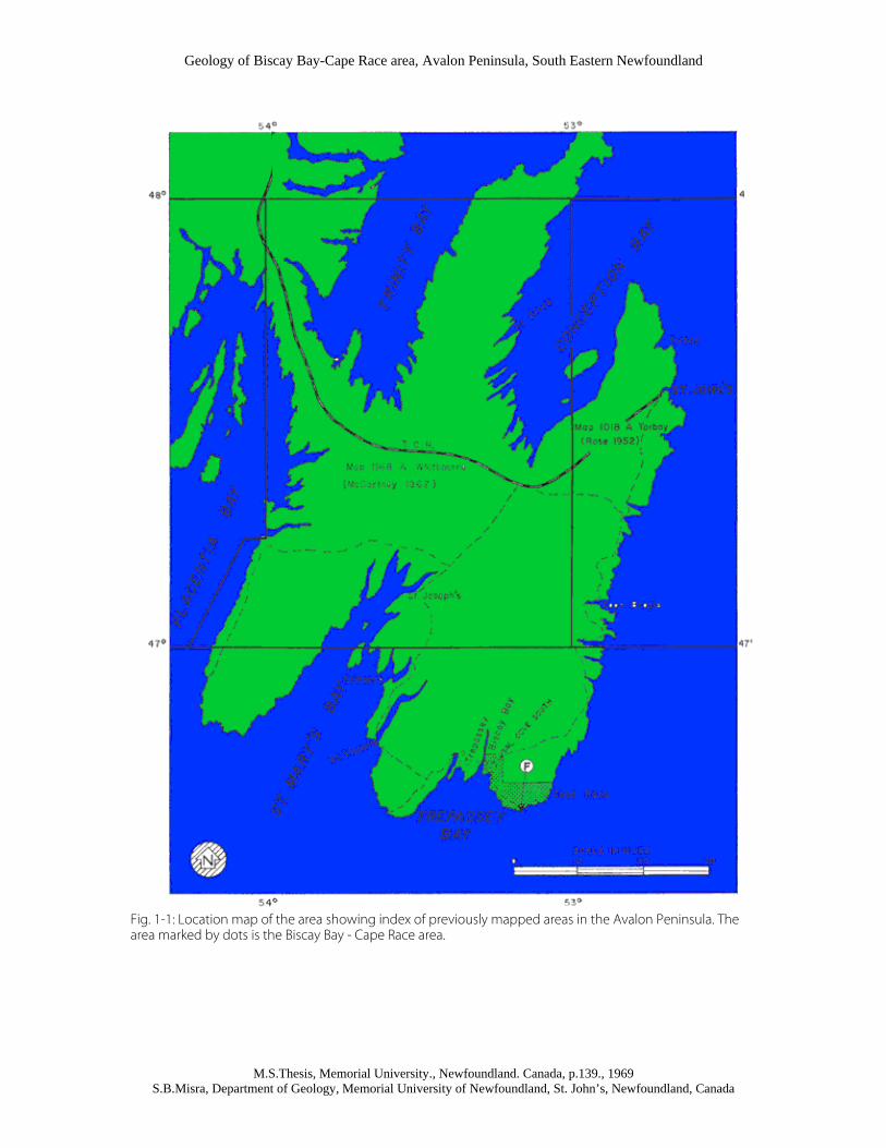
The Biscay Bay - Cape Race area lies on the extreme southeastern part of the Avalon Peninsula of Newfoundland (Fig. 1-1). The northern and southern boundaries of the area are marked by Lat. 46º 45' and 46º 38', the eastern and western boundaries by Long 53º 2' and 53º 17'. The area is accessible by road from St. John's which is 100 miles north of Biscay Bay. The northern half of the road (160km) is paved and there is a daily taxi service from Trepassey, the major community of the southern Avalon, to St. John's. One can also reach the area from the Trans-Canada Highway entering from the west via highways 6 and 7. Within the area, there is a secondary gravel road running from Trepassey via Portugal Cove South to the light house at Cape Race. Most of the coast-line is accessible by foot and can be easily traversed, except at a few places between Drook and Freshwater Point where the cliffs are almost vertical. A boat is helpful for studying these cliff sections. Inland the map-area is barren and easy to traverse in all directions. The most useful traverses are those along the course of rivers where bedrock is locally exposed. There are three settlements in the area namely Portugal Cove South, Biscay Bay, and Cape Race. The population of Portugal Cove South is 350 and that of Biscay Bay is 76 (1962 census); fishing is the main
Geology of Biscay Bay-Cape Race area, Avalon Peninsula, South Eastern Newfoundland
M.S.Thesis, Memorial University., Newfoundland. Canada, p.139., 1969 S.B.Misra, Department of Geology, Memorial University of Newfoundland, St. John’s, Newfoundland, Canada
industry. Only three families live at Cape Race and it is important for telecommunications, transmitting weather signals and for its light house that directs shipping.
Present Work
Most geological studies on the Avalon Peninsula have been confined to Torbay (Rose, 1952), and Whitbourne (McCartney, 1967) map areas. The area south of Lat 47 has not been mapped. The present study represents the first attempt at separation of the Conception Group from the overlying St.John's Formation in the southernmost part of the unmapped area. Field work for the present dissertation was completed during a four month period in the summer of 1967. Topographic maps no. I K/II Trepassey East and I K/Trepassey West, prepared by Surveys and Mapping Branch of the Department of Energy, Mines and Resources were enlarged and used for field mapping. Mapping was done on a scale of 1: 10,000 and the coastal geology is shown on four separate sheets (Plates 2-1, 2-2, 2-3 and 2-4). A geological map on a scale of 1: 50, 000is also provided to give a general picture of the area. An early reconnaissance study by the author showed that the distribution of rock types in the area was fairly clear. Rocks belonging to the St. John's Formation are exposed east and west of the Conception Group, indicating a regional anticlinal structure. Subsequent mapping confirmed this structural interpretation. Variations in rock types within the Conception Group were noticed even during reconnaissance studies. Later, it was found that the group is divisible into three lithological units each of formational status; the uppermost unit is fossiliferous and this represents the first discovery of definite Precambrian fossils in Newfoundland, except perhaps Aspidella terranovica Billings, a questionably organic form found in shales of the St. John's Formation. This dissertation is a general geological study highlighted by the following:
1. Discovery of Precambrian fossils 2. Three-fold classification of the Conception Group 3. Recognition of the St. John's Formation for the first time in this area. 4. Evidence of volcanism in the basal part of the St. John's Formation 5. Description of well developed turbidity features 6. Regional anticlinal structure
Physiography
Most of the area, a gently undulating plain with a few hills rising to 500 ft. is covered by bog, drift, and marsh with almost no trees. A general idea of the variation in thickness of drift, which varies from one or two feet to about thirty feet, may be had by traversing river courses. Outcrops are sparse except in the coastal regions. Ponds up to half a mile in length, generally irregular and in some cases oval, are found throughout the area. Many of them were produced by glacial action and at least two ponds near Cape Race appear to be kettle holes. Boulders of irregular shape and size, occurring on the marginal parts of the ponds, are probably washed from till and pushed ashore by local ice due to expansion in the volume of water after freezing. Small streams flow from one pond to another over a gently sloping surface. Their ability to perform geological work is largely dependent on the volume of the water provided to them by the ponds of their initiation. Such streams start meandering just after their initiation because of the gentle gradient of the land and low erosive power of the streams. The main rivers of the area for a southward radiating pattern and have uncovered the drift to expose bedrock, especially near the sea. Some of the rivers that constitute the drainage system are Back river, Portugal Cove brook, Drook River, Briscal Cove River, and Freshwater River. The coast-line shows a continuous exposure of bedrock except for local beaches of boulder, gravel, and sand especially at Biscay Bay, Portugal Cove South, and Long Beach. Its outline and shape vary in accordance with lithology and structure. A flat indented coast has developed on the well cleaved friable shales of the St. John's Formation while a steep indented coast has developed on the hard, siliceous massive cherts of the lower part of the Conception Group. The coastal areas where greywackes and argillites are exposed are

Geology of Biscay Bay-Cape Race area, Avalon Peninsula, South Eastern Newfoundland
M.S.Thesis, Memorial University., Newfoundland. Canada, p.139., 1969 S.B.Misra, Department of Geology, Memorial University of Newfoundland, St. John’s, Newfoundland, Canada
gently sloping except where controlled by structures. Most of the coves and embayments run either along fault planes or fold axes though glacial action has modified their form in many instances. Examples of fault controlled valleys may be seen at Drook, near Mistaken Point, and at Cape Race. A weak zone is locally produced in the crushed axial plane of a tight folded structure (Fig. 1-2). Erosion of rocks by sea action has resulted in a small natural bridge on the coast-line between Freshwater Point and Briscal Cove River. Some parts of the coast-line have indentations parallel to the strike of the beds and they have been formed by wave action along bedding planes e.g. the coast-line on the western bank of Cape Cove near Cape Race. Wave erosion has also resulted in development of deep vertical gorges along joint planes in cherts of the lower unit of the Conception Group. The material loosened as a result of compression along the joint planes is carried out to the sea by retreating waves. Considering the relative influence of lithology and structure, it is the latter that plays a decisive role. This is the reason why the coast near Cape Race is steep even though developed on the St. John's shales and it is gentle near Pigeon Cove Point even though formed on cherty argillites and cherts. In the coast-line development, the significance of lithology in the Torbay map-area (Rose, 1952) and of structures in the Harbour Grace area (Hutchinson, 1953) was reported, their relative role has not been described in the other parts of the Avalon Peninsula.
BEACHES
In the map-area, there are three well developed beaches and associated beach bars, at Biscay Bay, Portugal Cove South, and Long Beach, aligned approximately in the east west direction. The orientation of the beach bars indicates they are the result of the waves produced by strong northerly prevailing wind. The beach bars consist mostly of shingle (Fig. 1-3) which is bounded by pebbles and boulders. Although most of the material for the development of the beaches is derived from the drift in the off shore area, some of it is brought also by rivers that meet at the bay-heads. All three beaches are bay-head beaches separating a small lagoonal area in each case from the main body of water. The lagoonal areas in the case of Biscay Bay and Portugal Cove South are filled with water but at Long Beach it is marsh. There is no evidence of raised beaches in the map-area.
GLACIATION
Glacial drift, chatter marks and other erosional and depositional features all indicate that the area was glaciated. During the period of glaciations the hills were flattened and the valleys widened into U-shaped forms that have not been altered by subsequent drainage. Plaination of the area is generally complete and flat boulder surfaces have resulted where the finer material has been washed out, although Brueckner (1967, Personal communication) is of the view that a boulder surface between Capaheden and Portugal Cove South is the result of solifluxion. The boulders in the drift consist of chert, siliceous argillites, siltstone, greywackes and rarely shales, mostly of local origin. Glacial boulders of igneous or volcanic rocks are almost absent but a diorite erratic of approximately 20 ft diameter was seen inland about six miles north of Portugal Cove South.
Geology of Biscay Bay-Cape Race area, Avalon Peninsula, South Eastern Newfoundland
M.S.Thesis, Memorial University., Newfoundland. Canada, p.139., 1969 S.B.Misra, Department of Geology, Memorial University of Newfoundland, St. John’s, Newfoundland, Canada
Fig. 1-1: Location map of the area showing index of previously mapped areas in the Avalon Peninsula. The area marked by dots is the Biscay Bay - Cape Race area.

Geology of Biscay Bay-Cape Race area, Avalon Peninsula, South Eastern Newfoundland
M.S.Thesis, Memorial University., Newfoundland. Canada, p.139., 1969 S.B.Misra, Department of Geology, Memorial University of Newfoundland, St. John’s, Newfoundland, Canada
Fig. 1 – 2: A tightly folded anticline in the Cape Cove Formation between Mistaken Point and Briscal Cove River. Sea waves formed a cave along the anticlinal axis by taking the rock material away. This is how an embayment starts along a fold axis.
Fig. 1 – 3: Typical boulder beach of southern Avalon viewed looking east toward Trepassey. The beach material is derived from glacial drift.

Geology of Biscay Bay-Cape Race area, Avalon Peninsula, South Eastern Newfoundland
M.S.Thesis, Memorial University., Newfoundland. Canada, p.139., 1969 S.B.Misra, Department of Geology, Memorial University of Newfoundland, St. John’s, Newfoundland, Canada
CHAPTER II
General Geology The Biscay Bay - Cape Race area is underlain by a thick sequence of Precambrian sedimentary rocks which can be separated, even though there is a gradational boundary, into two main divisions: a lower division consisting of banded cherts, argillites, greywackes, and siltstones corresponding to the Conception Group (Rose, 1952); an upper division consisting of shales with sandstone laminae and sandy streaks corresponding to the St. John's Formation (Rose, 1952). The rocks of the lower division are mainly green and purple. Those of the upper division are various shades of grey.
TABLE OF FORMATIONS
Age Group Formation Lithology
Cabot St.John's 1100 ft. Well cleaved grey shales with sandstone laminae and sandy streaks
Gradational Boundary
Cape Cove 3000ft.
Graded beds of greywackes, siltstone, and well cleaved green argillites; purple argillites and greywackes in the upper part of the formation
Gradational Boundary
Freshwater Point 1500 ft
Green siliceous argillites with some greywackes
Gradational Boundary
Late Precambrian
Conception
Drook 2500ft. Banded cherts and silicified argillites and siltstones.
Brief visits to the area were made by Professors Neale, Brueckner, Williams, Kennedy, King, and Anderson. All agree that the proposed division is well founded and that the Lithological correlation of the divisions with the Conception Group and the St. John's Formation is clear and definite.
Conception Group
The Conception Group was defined by Rose (1952) as a thick sequence of sedimentary rocks overlying the Harbour Main group and underlying the St. John's Formation of the Cabot Group. He divided the Conception Group into two rock units, the 'Conception Slate' and the 'Torbay slate'. However, a formal classification was not proposed. In the adjoining Whitbourne map-area, McCartney (1967) made no attempt to subdivide the Conception Group. In the Biscay Bay - Cape Race area, the Conception Group can be divided into three formations here named: the Drook Formation, the Freshwater Point Formation, and the Cape Cove Formation in order of decreasing age. Although the rock units are separated by gradational boundaries, each formation has its own characteristics that distinguish it from overlying and underlying formations. Rocks of the Conception Group throughout the Avalon Peninsula have previously been referred to as slaty siltstone, slates, argillites, mudstones etc. Although these lithologies are not easily compared there is some suggestion of facies change from fine sediments in the west to coarser in east.
Drook Formation
NAME

Geology of Biscay Bay-Cape Race area, Avalon Peninsula, South Eastern Newfoundland
M.S.Thesis, Memorial University., Newfoundland. Canada, p.139., 1969 S.B.Misra, Department of Geology, Memorial University of Newfoundland, St. John’s, Newfoundland, Canada
The name Drook Formation is proposed for a sequence of banded cherts and highly siliceous argillites which are the oldest rocks of the area. The type area is Drook, three miles east of Portugal Cove South.
DISTRIBUTION AND THICKNESS
Rocks of the Drook Formation occupy the core of a regional anticlinorium with axis trending northeast through Freshwater Bay. The western boundary of the formation lies just east of Pigeon Cove Point and the eastern boundary lies half a mile west of Freshwater Point (Plate 2-3). Apart from coastal exposures the formation is found in numerous outcrops along Drook River, which runs in a valley along the axis of the anticlinorium.
The thickness of the formation estimated from exposures of the western flank of the anticlinorium is about 2500 ft.
LITHOLOGY
The Drook Formation comprises well bedded, gently folded banded cherts and siliceous argillites (Fig. 2-2). Many of the chert beds are silicified siltstones and each bed has its characteristic colour, usually containing shades of green that are more accentuated on the exposed surface. The thickness of the beds varies from a fraction of an inch to two inches.
The cherts and siliceous argillites are exceptionally hard and compact. In places, the rocks are fractured but cleavage is rarely well developed. They break with conchoidal fracture and sharp edges on the fresh surface, but when crushed or jointed, weather into cubic, rhomboidal, or irregular fragments. The cherts are easily crushed and brecciate even along minor faults. Nevertheless, they are very resistant to weathering and form the areas of greatest relief near Drook.
The most common constituents of the rocks, as identified from X-Ray diffraction are quartz, albite, chlorite, and sericite (Table I). The other constituents are epidote, siderite (?), and leucoxene. Clay minerals are absent. Calcite is found only in the form of concretions, such as ellipsoidal nodules, concretionary silty blocks and concretionary, limy chert etc.
RELATION TO UNDERLYING AND OVERLYING ROCKS
The base of the formation is not exposed in the area and the contract relation between the Conception Group and the underlying rocks is unknown. However, the oldest beds of the formation exposed along Drook River are almost pure chert.
The upper boundary of the formation is gradational with a gradual increase in the argillaceous and arenaceous material and decrease in silicification. Near Pigeon cove Point the transition zone, between the Drook and Freshwater Point Formation, includes two layers of pseudo oolitic concretionary chert of about 2 thickness.
TABLE I : VARIATION IN QUARTZ WITH RESPECT TO OTHER MINERALS (From X-Ray diffraction) sample No. Q/A Q/Chl. Q/cal. Chl./Seri. Formation MCR-26 3.25 3.40 - 1.55 St. John's MCR-18 3.25 3.25 - 1.78 St. John's MCR-2 1.99 2.36 3.20 1.90 St. John's ESH-4 2.61 3.65 1.58 1.59 St. John's MCC-25 3.89 3.70 - 1.69 Cape Cove MLB-20 3.50 4.36 - 1.29 Cape Cove MLB-46 3.20 3.23 - 1.26 Cape Cove MFP-2 3.12 3.26 - 1.12 Cape Cove MCC-3 4.44 4.26 - 1.30 Freshwater Point MPC-24 2.05 2.85 - 1.16 Freshwater Point MPC-14 2.90 2.40 - 1.48 Drook

Geology of Biscay Bay-Cape Race area, Avalon Peninsula, South Eastern Newfoundland
M.S.Thesis, Memorial University., Newfoundland. Canada, p.139., 1969 S.B.Misra, Department of Geology, Memorial University of Newfoundland, St. John’s, Newfoundland, Canada
MPC-8 4.00 5.56 - 1.50 Drook Q= quartz, A= Felspar, Chl. = Chlorite, Seri. = Sericite
Freshwater Point Formation
NAME
The Freshwater Point Formation is proposed for a sequence of predominantly argillaceous beds underlain by the Drook Formation and overlain by the Cape Cove Formation.
DISTRIBUTION AND THICKNESS
The Freshwater Point Formation is exposed in coastal areas on the western and eastern limbs of the anticlinorium where it overlies the Drook Formation with a gradational boundary. The western coastal section near Daly's Point is not complete because of a boulder beach along that part of the coast. The eastern coastal section is complete and stretches for more than one mile.
An estimated minimum thickness of the formation is about 1500 ft.
LITHOLOGY
The Freshwater Pointy Formation is composed of siliceous argillites and siltstones, locally with minor proportions of medium to fine gained sandstone found at the base of the graded beds. The sandstones have a composition similar to those of the overlying Cape Cove greywackes (Table II), but are better sorted. The sandstones are composed of subangular to subrounded grains of quartz, felspar, and rock fragments, exhibiting a bimodal texture. The matrix is composed of chlorite, sericite, epidote, leucoxene, and sphene etc.
The diffraction patterns of some of the fine grained rocks reveal that quartz, albite, and chlorite and sericite are the common constituents. Clay minerals are absent. Chlorite which is chiefly responsible for the green colour of the rocks, is derived from more than one source, but mainly from alteration of basic rock fragments and clay minerals. The accessory minerals include epidote, leucoxene and sphene.
The fine grained sediments of the Freshwater Point Formation are green, the sandstones grey and the weathered product whitish. Weathered fragments are slab like and parallel fracture cleavage planes. Fracture cleavage is common but rarely well developed. The rocks are also cut by numerous joints parallel with or normal to the bedding planes.
RELATION TO UNDERLYING AND OVERLYING ROCKS
The upper part of the formation consists of graded beds, which are composed of sandstone through siltstone to siliceous argillites, with the basal sandstone part less that 20% of a graded unit. The upper boundary of the formation is drawn where the greywacke part of graded beds becomes 20% or more.
Thus the boundaries of the Freshwater Point Formation with the underlying Drook Formation and the overlying Cape Cove Formation are gradational.
Cape Cove Formation
NAME
Geology of Biscay Bay-Cape Race area, Avalon Peninsula, South Eastern Newfoundland
M.S.Thesis, Memorial University., Newfoundland. Canada, p.139., 1969 S.B.Misra, Department of Geology, Memorial University of Newfoundland, St. John’s, Newfoundland, Canada
The name Cape Cove Formation is proposed for a sequence of graded beds that overlies the Freshwater Point Formation and underlies the St. John's Formation. The type section is exposed along the western side of Cape Cove, near Cape Race.
DISTRIBUTION AND THICKNESS
In addition to the type section, there are two coastal exposures of the formation. One of them is from Big Cove to Long Beach and the other in Portugal Cove South. Exposures of the formation are found also along Portugal Cove Brook and Briscal Cove river.
An estimated thickness of the formation is 2700 ft., which is overlain by a transition zone of about 400 ft.
LITHOLOGY
The main part of the Cape Cove Formation comprises graded beds of greywackes, siltstones, and well-cleaved green argillites. The beds are up to 10 ft. thick and maintain a uniform thickness along strike for scores of feet. The proportion of greywackes in the graded beds reaches a maximum of about 60% in the middle part of the formation and then decreases in the overlying beds decreasing upward.
The upper part of the formation included graded beds of greywackes, siltstones and purple argillites. These greywackes are darker in colour and finer in grain size than those in the lower party of the formation. The purple colour in the argillites is probably due to a change in the environment during sedimentation of these rocks (see page 128).
Several bedding features occur on top as well as on bottom surfaces of the graded units. They locally include ripple marks and organic markings on the top of the beds and sole markings on the undersurfaces of the graded units. The contacts of successive graded beds are, however, well defined. Sharpness of a contact can be seen even in a thin section (Fig. 2-7).
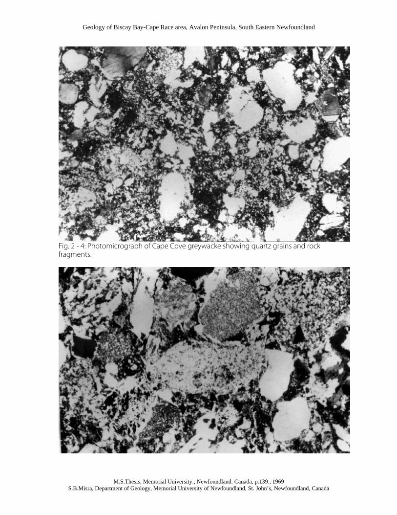
Nine specimens of the Cape Cove greywackes wee examined in thin section. The compositions, as determined by micrometric analysis are plotted in Fig. 2-1. In these specimens detrital quartz forms 22 to 38 per cent of the rock (Table II). Quartz grains are chiefly subangular to subrounded. Felspar grains are similar in shape to the quartz but in general are smaller. The felspar is sodic plagioclase; in part untwined. Many plagioclase grains are sericitic or cloudy; others are clear and show no signs of alteration. Rock fragments consist of chert, rhyolite, microgranite and basic volcanic rocks (Figs. 2-4, 2-5 and 2-6). The matrix generally comprises 40 55 percent of the rock, and is composed of chlorite, biotite, sphene, epidote, leucoxene, pyrite, and very rarely apatite.
Mineral constituents of the siltstones and argillites, as determined from X-Ray diffraction, are quartz, felspar, chlorite, and sericite. The rock fragments are absent as they break into individual minerals. Also, finer grained rocks have a higher proportion of opaque minerals.
TABLE II : VOLUME PERCENTAGE OF GREYWACKE CONSTITUENTS
Sp. No. Quartz grains Felspar grains Rock Frag. G.M.(matrix) PP-5 26.59 2.84 25.86 43.06 LP-2 25.00 4.20 6.60 64.0 SB-1 33.00 2.20 19.60 44.00 HBP-7B 27.50 2.80 18.30 51.50 MLB-50 38.50 4.50 15.50 41.50 MLB-60 29.50 4.60 18.80 49.50 MHW-6 22.70 5.50 18.00 54.00 PP-16 28.20 7.60 20.50 44.00 MCC-21 31.80 8.40 9.50 50.00
Rock Frag. = Rock Fragments G.M. = Ground Mass (matrix)

Geology of Biscay Bay-Cape Race area, Avalon Peninsula, South Eastern Newfoundland
M.S.Thesis, Memorial University., Newfoundland. Canada, p.139., 1969 S.B.Misra, Department of Geology, Memorial University of Newfoundland, St. John’s, Newfoundland, Canada
Age and Correlation
Cabot Group
St. John's Formation
DISTRIBUTION AND THICKNESS:
The St. John's Formation in the map area consists of a sequence of well cleaved dark to light grey shales that overlies the Cape Cove Formation. There are two coastal exposures, the first from Cape Race to Shingle Head, and the second from Biscay Bay to Portugal Cove South. The second exposure continues westward to the adjoining Trepassey area. Apart from these coastal exposures the formation is found in several outcrops along Back river and also along other unnamed brooks near Cape Race.
An estimated thickness of that part of the formation exposed in the area is about 1100 ft.
LITHOLOGY :
The basal part of the St. John's Formation consists of grey, well cleaved, thin bedded shales intercalated with sandstone laminae (Fig. 2-10). In this part of the formation and also in the transition zone immediately below, one commonly finds well developed crystals of pyrite in the sandstone beds. Disseminated pyrite is ubiquitous.
Near Shingle Head (Plate 2-2), the basal part of the St. John's Formation includes a layer of volcanic tuff of about 2 ft. thickness. The rock consists of quartz, plagioclase, calcite, sericite, etc. with a tuffaceous texture portrayed by shards, volcanic matrix and subhedral grains of felspar etc. The shards are clear and plentiful (Fig. 2-9) . This is the first record of volcanism in the St. John's Formation.
The main part of the formation is predominantly thin bedded, grey shales, with intercalated sandy streaks. Fracture cleavage is very pronounced and obscures bedding in some places. In other places, the relation between cleavage and bedding is distinct (Fig. 2-11). The weathered surfaces are masked by rust derived from weathering of pyrite, which is common in the St. John's Formation.
Near Cape Race and also at Portugal Cove Point, the formation includes dens, dark grey, calcareous layers of 2-3 inches thickness, some of which in thin section exhibit cone -in-cone structure. In the same association one finds calcareous, cherty, and sandstone nodules locally showing a concentric internal structure caused by slumping. Well developed slump structures and associated features are found throughout the formation.
The rocks are commonly composed of quartz, felspar, mica, chlorite, and pyrite. Quartz grains in some calcareous sandstones gradually merge with calcite grains, indicating an incomplete replacement of one mineral by the other. Furthermore, some of the fine grained calcareous sandstones exhibit a patchy extinction caused by partial replacement of quartz by calcite, which must have taken place during or after digenesis of the rocks, as most of the quartz grains are diagenesis in origin.
The accessory minerals are normally the same as in the Conception argillites, except that pyrite is more common and calcite more frequent. The results obtained from X-Ray diffraction of the shales reveal that clay minerals are absent.
RELATION TO UNDERLYING AND OVERLYING ROCKS:

Geology of Biscay Bay-Cape Race area, Avalon Peninsula, South Eastern Newfoundland
M.S.Thesis, Memorial University., Newfoundland. Canada, p.139., 1969 S.B.Misra, Department of Geology, Memorial University of Newfoundland, St. John’s, Newfoundland, Canada
The lower boundary of the formation is gradational and the upper boundary is not exposed. However, in theTorbay map-area the formation is conformably overlain by the (Precambrian) Signal Hill Formation (Rose, 1952).
Plates
Fig. 2 – 2: Photograph showing southerly dipping beds of the Drook Formation west of Drook Point. Note the bedding, joints and the pattern of weathering in the cherts.
Fig. 2 – 3: Photograph showing ripple marked joints and the fractured surface of the purple argillites that contain fossil impressions near Mistaken Point. For location see plate 2 – 2
Geology of Biscay Bay-Cape Race area, Avalon Peninsula, South Eastern Newfoundland
M.S.Thesis, Memorial University., Newfoundland. Canada, p.139., 1969 S.B.Misra, Department of Geology, Memorial University of Newfoundland, St. John’s, Newfoundland, Canada
Fig. 2 - 4: Photomicrograph of Cape Cove greywacke showing quartz grains and rock fragments.

Geology of Biscay Bay-Cape Race area, Avalon Peninsula, South Eastern Newfoundland
M.S.Thesis, Memorial University., Newfoundland. Canada, p.139., 1969 S.B.Misra, Department of Geology, Memorial University of Newfoundland, St. John’s, Newfoundland, Canada
Fig. 2 - 5: Photomicrograph of Cape Cove greywacke showing altered rock fragments with their outline diffused with the groundmass (matrix) producing thereby an indistinct or fuzzy texture. X32 (approx.) under crossed nicols.
Fig. 2 - 6: Photomicrograph showing basic volcanic rock fragments in the Cape Cove greywacke. X32 (approx.) under crossed nicols.

Geology of Biscay Bay-Cape Race area, Avalon Peninsula, South Eastern Newfoundland
M.S.Thesis, Memorial University., Newfoundland. Canada, p.139., 1969 S.B.Misra, Department of Geology, Memorial University of Newfoundland, St. John’s, Newfoundland, Canada
Fig. 2 - 7: Photomicrograph showing a sharp contact between two consecutive graded beds of the Cape Cove Formation. Note the dark grains of pyrite in the argillite. X32 (approx.) under crossed nicols.

Geology of Biscay Bay-Cape Race area, Avalon Peninsula, South Eastern Newfoundland
M.S.Thesis, Memorial University., Newfoundland. Canada, p.139., 1969 S.B.Misra, Department of Geology, Memorial University of Newfoundland, St. John’s, Newfoundland, Canada
Fig. 2 - 8: Photomicrograph of a thin calcareous layer showing cone-in-cone structure. Note the cleavage in calcite. X32 (approx.) under crossed nicols
Fig. 2 - 9: Photomicrograph of volcanic tuff of the St. John's Formation showing devitrified glass (shards). X32 (approx.) under crossed nicols.

Geology of Biscay Bay-Cape Race area, Avalon Peninsula, South Eastern Newfoundland
M.S.Thesis, Memorial University., Newfoundland. Canada, p.139., 1969 S.B.Misra, Department of Geology, Memorial University of Newfoundland, St. John’s, Newfoundland, Canada
Fig. 2 - 10: Well-cleaved shales with interbedded sandstone laminae in the basal part of the St. John's Formation near Cape Race.
Fig. 2 - 11: Well cleaved St. John's shales with intercalated sandy streaks. Note the relation between cleavage and bedding.

Geology of Biscay Bay-Cape Race area, Avalon Peninsula, South Eastern Newfoundland
M.S.Thesis, Memorial University., Newfoundland. Canada, p.139., 1969 S.B.Misra, Department of Geology, Memorial University of Newfoundland, St. John’s, Newfoundland, Canada
CHAPTER III
Primary Sedimentary Structures Primary sedimentary structures are exhibited by all formations in the map-area and include external and internal forms of bedding, organic and inorganic markings on top and under surfaces of the beds, and penecontemporaneous deformations. The distribution of primary structures in various lithologic units is controlled by lithology, conditions of deposition, and the transporting agencies that brought the sediments to the basin.
A genetic classification of primary sedimentary features is not feasible but they can be classified descriptively according to the following scheme (based on Potter and Pettijohn, 1964, p3):
CLASSIFICATION OF SEDIMENTARY STRUCTURES
Group Class Sedimentary Features
Bedding : external form Class A
1. Bedding equal or sub-equal in thickness
2. Beds laterally uniform in thickness
3. Beds continuous
Class B 1. Beds unequal in thickness
2. Beds continuous
Bedding: internal organization and structure
Class A
1. Massive
Class B 1. Laminated: (a) Horizontal lamination
(b) Cross lamination
Class C 1. Graded
Bedding: Plane markings and irregularities
Class A
1. On base of the beds: sole marks.
Class B 1. Within the bed: concretions, cone-in-cone, nodules etc.
Class C 1. On top of the beds : ripple marks
Bedding: deformed by penecontemporaneous processes
Class A
Class B 1. Founder and load structures
1. Slump structures: folds, faults, pseudonodules, discoidal pyrite etc.
BEDDING EXTERNAL FORM All rocks in the area are stratified as evidenced by colour, texture, dimensions of particles and composition. In some instances, stratification is made more obvious by jointing that separates the rocks into joint sheets which parallel the bedding planes.

Geology of Biscay Bay-Cape Race area, Avalon Peninsula, South Eastern Newfoundland
M.S.Thesis, Memorial University., Newfoundland. Canada, p.139., 1969 S.B.Misra, Department of Geology, Memorial University of Newfoundland, St. John’s, Newfoundland, Canada
The beds in the Drook Formation are 1 to 2 inches thick and show distinct colours (Fig. 3 - 8) which contrast sharply against one another. The thickness of beds increases gradually upward in the sequence and reaches a maximum of about 9 ft in the middle part of the Cape Cove Formation. A decrease in thickness of the beds starts after they reach this maximum and continues until the beds reduce to the thickness of a lamina (Fig. 3 - 1) or even a streak (Fig. 3 - 2) in the St. John's formation.
Most of the beds are laterally uniform in thickness and are continuous throughout the exposures which in some cases stretch as far as 500 ft. In other words, most of the beds in the map area belong to the class A of the group but some, especially those deposited during increasing or decreasing intensity of turbidity currents, belong to the Class B.
The lower and upper contacts of the beds and laminae, either graded (Fig. 3 - 7) or ungraded (Fig. 3 - 8), are generally sharp, though locally marked with irregularities, especially on the under surfaces of the beds in the Cape Cove Formation. A structure caused by disruption of a sand layer is locally seen in the sandstone beds in the Freshwater Point Formation (Fig. 3 - 4).
BEDDING INTERNAL ORGANIZATION AND STRUCTURE
Massive
Rocks of the Drook Formation (Fig. 2 - 2) and of the Freshwater Point Formation, in some exposures, exhibit a massive appearance. However, a closer view of the rocks reveals that they are characterized by bedding planes, either as colour bands or as graded units. Some of the argillites in the thin section show a poorly developed alignment of flaky minerals almost parallel to the bedding planes except where they are parallel to the foreset part of the cross stratification. However, it is difficult to confirm their primary nature as most of the rocks are highly altered.
Laminated
HORIZONTAL LAMINATION
Horizontal lamination is exhibited by most rocks in the Conception Group and the St. John's Formation. Each bed or lamina represents a depositional unit laid down in most cases by turbidity currents, and manifests itself by the colour, grain size, and/or bedding plane markings.
Some of the shales and siltstones of the St. John's Formation in thin section exhibit horizontal lamination demonstrated by arrangement of minerals, with heavy minerals arranged in a row (Fig. 3 - 9) along the bottom of the laminae which are locally deformed by the weight of overlying sediments (fig. 3 - 10). The internal organization of silty shales in the St. John's Formation is well defined but in argillites of the Conception Group it is indistinct.
CROSS STRATIFICATION
Cross bedding occurs as small-scale cross stratified units in the St. John's Formation and also in the underlying transition zone between the Conception and Cabot Groups. Cross stratification found in these rocks is believed to have been formed by traction currents when the turbidity currents had become weak. However, in the outcrops of the transition zone, cross bedded units alternate with shales and graded units, suggesting that turbidity currents were still in operation.
Most common types of cross stratification are solitary sets and co-sets (Allen, 1963) forming current ripple lamination in some instances. An important aspect of the cross stratification in this area is the thickness of individual sets (fig. 3 - 5) and co-sets (Fig. 3 - 6) which are hardly more than 5 cm. thick.

Geology of Biscay Bay-Cape Race area, Avalon Peninsula, South Eastern Newfoundland
M.S.Thesis, Memorial University., Newfoundland. Canada, p.139., 1969 S.B.Misra, Department of Geology, Memorial University of Newfoundland, St. John’s, Newfoundland, Canada
The angle of inclination of foreset beds varies from 20 - 35 degrees in most cases. Measurements of dip direction of foreset laminae in the two coastal exposures of the St. John's Formation, along eastern coast of Biscay Bay and near Cripple Rock Point, indicate that the structures were formed by a north to south current system. Scattered measurements from the entire area suggest that such an orientation is general.
Ten readings of current direction from cross bedding in the St. John's Formation are plotted on a palaeocurrent map (Plate 3 - 1) without correction of the tilt of the beds. The tilt, however, is low and the general direction of movement from the cross stratification is in agreement with directions obtained from sole marking and slumping.
Graded Bedding
Graded bedding is portrayed in all the three exposures of the Cape Cove Formation (Plates 2 - 1, 2 - 2, 2 - 3) but is best developed in the outcrops near Briscal Cove river. It occurs also in some horizons of the Freshwater Point Formation. Graded bedding was caused by settling of suspended sediments which settled in accordance with dimensions, specific gravities, and shapes. Settling of the sediments must have taken place during the interval between two consecutive turbidity currents.
Grading in the sediments is evident by a colour change from light grey to green or purple, which reflects a change in grain size. Graded beds in the turbidite sequence of the Cape Cove Formation vary in thickness from 3 to 9 ft. in most places and consist of greywackes at the bottom grading upward through siltstone into argillites. The finer upper part of each graded bed ends abruptly against the coarse base of the next overlying layer (Fig. 3 - 7).
Although graded bedding and cross bedding are mutually exclusive, there are some beds in the basal part of the St. John's Formation near Portugal Cove bridge that exhibit graded bedding in the lower part and small scale cross bedding with convolute bedding in the upper part.
BEDDING PLANE MARKINGS AND IRREGULARITIES
On base of beds
SOLE MARKS
Sole marks are restricted to the greywackes of the Cape Cove Formation. They include flute casts (Fig. 3-11), load casts, and groove casts (prod marks) which are mutually exclusive in this area. These structures are better developed in coarser greywackes than in medium or fine grained ones.
Flute casts (Fig. 3 - 12) up to 6 inches in length were seen on the soles of 3 - 9 ft thick graded beds along the coast-line between Mistaken Point and Briscal Cove River. The long axes of the flute casts are parallel to the average current direction which can be confirmed by other means such as cross stratification, slumping, and prod markings. One end of the structures ends more abruptly against the sole face, usually flaring out with a dextral bend. The end that merges gradually into the sole surface normally marks the down current direction.
Some bulbous irregularities on the under side of the greywackes were seen between Freshwater Point and Briscal Cove river. The structures, up to 1' in diameter and 3 inches in height above the sole surface, are different from flute casts in their much greater irregularity of form and absence of distinct current trends. The structures can be classified as load casts that were, presumably, formed at an early stage of deposition. The structures consist of the material which is coarser than or at least as coarse as the base of the beds in which they occur.
At Long Point, the soles of graded beds are marked with well defined grooves and ridges that taper in a S30E direction. A few fade out in the same direction. These features. although constituting grooves and

Geology of Biscay Bay-Cape Race area, Avalon Peninsula, South Eastern Newfoundland
M.S.Thesis, Memorial University., Newfoundland. Canada, p.139., 1969 S.B.Misra, Department of Geology, Memorial University of Newfoundland, St. John’s, Newfoundland, Canada
ridges, are not continuous throughout the entire length of the exposed surface and are probably prod marks (Potter and Pettijohn, 1963, p.122)
Within the Bed or Bedding Planes
The structures included under this heading have probably more than one mode of origin and some of them, especially concretionary structures, were excluded from sedimentary features by Potter and Pettijohn (1964). The structures such as cone-in-cone, stylolites, concretions etc. were, probably, formed after deposition and during consolidation of the sediments. Sandstone lenses and ellipsoidal nodules are also represented and formed during the actual process of sedimentation.
CONCRETIONS:
Two types of concretions occur in the rocks of the Drook Formation. One of them consists of concretionary siltstone blocks (Fig. 3 - 14) of red colour and about 2 ft. maximum diameter. The other type is ellipsoidal nodules composed of calcareous sandstone, found on both sides of Freshwater Bay.
The ellipsoidal nodules have a consistently flatter bottom side resting in a shallow depression; the curvature of the top side is distinctly convex upward (Fig. 3 - 13). Although the nodules are also slightly convex downward, most of their mass lies above the general surface of the bedding on which they lie. The colour bands in the cherts are bent below the ellipsoidal nodules suggesting a relative competence of the nodules over the cherts at the time of their formation.
CONE - IN - CONE :
Cone-in - cone structures were noted in the St. John's Formation where they consist of a nest of concentric cones arranged at right angles to the bedding surface, and ranging in height up to about 3 mm. The structures are distinct only in thin section (fig. 2 -8) and are hard to identify with the unaided eye, and as such they may be termed as micro-cones. The calcareous layers containing cone-in-cone structures are mostly less than 2 inches in thickness and are interbedded with shales in the St. John's Formation.
The structures were probably caused by pressure due to the weight of the overlying sediments. Pressure is also evidenced by bedding in some associated thin sedimentary layers. Stylolytes accompanying cone-in-come structures are also the result of this pressure.
On Top of the Beds
At some places near Drook the top surfaces of the chert beds in the lower part of the Conception Group contain current formed mega ripples that measure 2 - 3 ft. from crest to crest. It is difficult to determine the direction of currents as the amplitude of ripples is low and the exposed surface has been worn down by wave action. Nevertheless, some instances indicate a southward moving current. The ripple marked surfaces in some instances are cracked along the crest of the ripple but no evidence of a diastrophic origin for the undulations is seen.
A second type of irregularity found on the top of the beds is due to impressions made by organisms living in the Conception Sea during the period of sedimentation (Fig. 2 -3). No other organic markings like trails, burrows, etc. were seen.
BEDDING DEFORMED BY PENECONTEMPORANEOUS PROCESSES
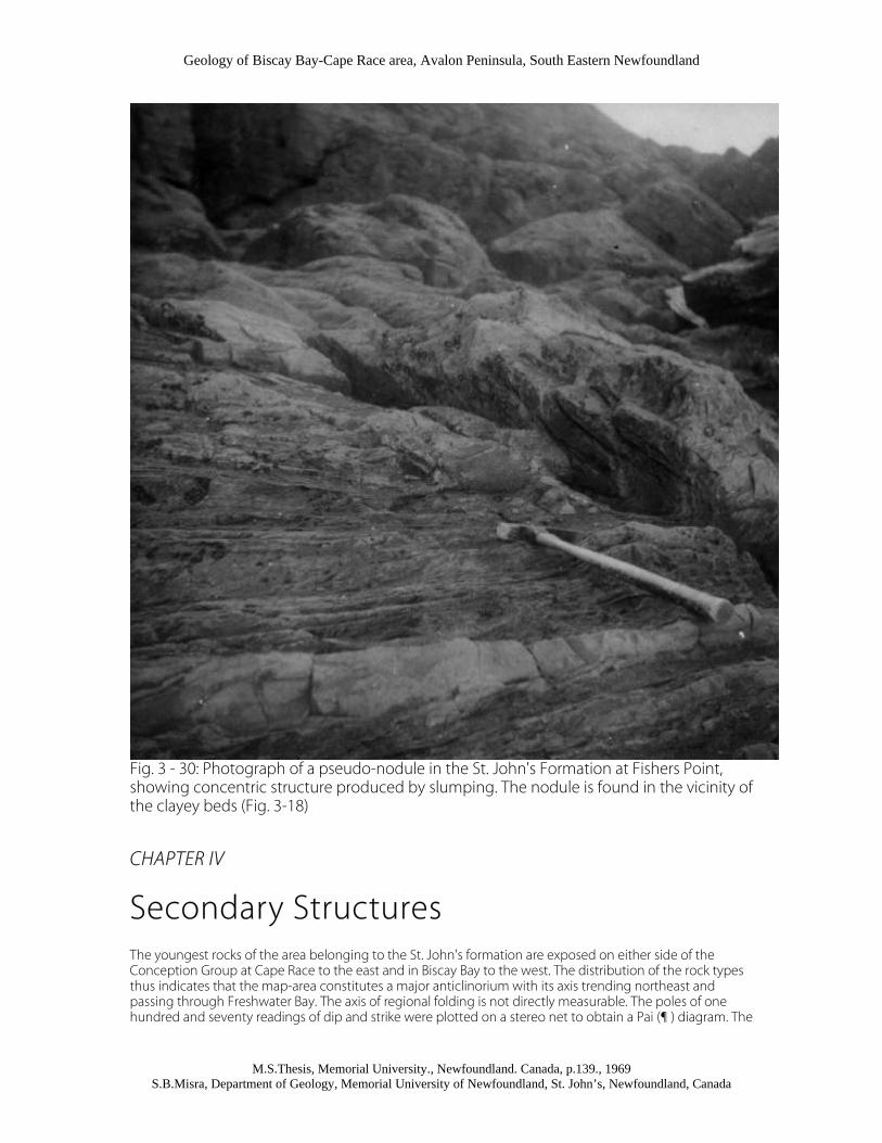
Foundering or Thixotropy
At several places in the map area there are within the St. John's Formation, calcareous (Fig. 3 -30) and cherty nodules formed possibly by agitation or foundering of a partly lithified thin layer. The nodules are generally
Geology of Biscay Bay-Cape Race area, Avalon Peninsula, South Eastern Newfoundland
M.S.Thesis, Memorial University., Newfoundland. Canada, p.139., 1969 S.B.Misra, Department of Geology, Memorial University of Newfoundland, St. John’s, Newfoundland, Canada
sub-rounded in shape, locally stretched and elongate, and occur invariably along the strike of the beds. These deformations do not involve lateral movement of the material and are generally confined to a single layer underlain and overlain by undeformed beds. Kuenen (1959) produced pseudonodules experimentally by a process involving the foundering of sands interbedded with shales and he concluded that an earthquake might be the triggering mechanism.
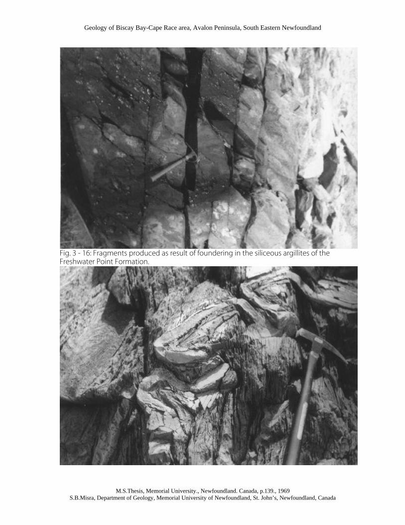
A similar deformation of a thin chert layer near Drook resulted in randomly arranged, locally folded, elongate fragments (Fig. 3 -15), which are in some cases coated with a thin whitish material. The Freshwater Point argillites yield ellipsoidal and irregular fragments (Fig. 3 - 16). It seems unlikely that an unconsolidated layer could be broken into fragments, because such a layer would yield by disintegration and flowage during slumping. On the other hand if sediments were consolidated they could not be expected to fold. The sediments were, probably, in a semi-lithified state.
Slump Structures
Slumping in the map-area is mostly confined to the St. John's Formation within which structures of various sizes have been produced as a result of contortion of the beds. The structures are governed, among other things, by the relative competence of the two lithologies in juxtaposition at the time of slumping. Cherts, clayey sediments, shales and calcareous sandstones form better developed slump structures than silty argillites and graded sandstones which are almost devoid of these features.
SLUMP FOLDS
The most common features produced by slumping is folds of all dimensions, most asymmetrical, locally overturned, and varying in form from simple asymmetrical anticlines to recumbent and nappe- like folds (Fig. 3 - 17). In general, slump folds are most prominent and are largest immediately above the basal part of the St. John's Formation. Some of the folds near Fisher's Point have their axial planes almost vertical (Fig. 3 - 18) and affect 50' of strata.
Thin layers of calcareous clay and sandstone in the St. John's Formation near Fishers Point and Shingle Head are more intensely contorted than siltstone and shale interbeds which appear to have acted as relatively competent beds.
The layers of clayey material before they were contorted were folded such that the shaly material was sandwiched between a clay layer and the composite set was then contorted to give rise to the folds that can be seen in the vertical section at Shingle Head (Fig. 3 - 17) and in a horizontal section near Fishers Point (Fig. 3 - 18). Some parts of the calcareous sandstone layers have become thicker than the other parts (Fig. 3 - 18). These sand tumors are the result of sediment accumulation during slumping.
Intercalated sandstone laminae and sandy streaks in the St. John's Formation accentuate the slump folds (Fig.3 - 19) and faults (Fig. 3 - 20); the structures are also more obvious on weathered surfaces (Figs. 3-21, 3-22) than on fresh surfaces, probably because of small-scale differential weathering.
The axes of slump folds near Portugal Cove Point trend N40W which is at right angles to the axial trend of tectonic folds. In most other cases the axial trends of slump folds are variable. The localization of the slump folds between undisturbed strata clearly indicates their primary origin (Fig. 3-23, 3-24). Structural arrangements in the slump zones are usually complex with normal and reverse structures being present in the same bed within short distances. Some features (Fig. 3-25) bear striking resemblance to drag folds but do not conform to the tectonic deformation pattern in the area.
SANDSTONE CYLINDER
On the western coast of Biscay Bay, a sandstone layer of about 1' thickness has rolled in a cylindrical form (Fig. 3-26). The axis of the cylinder trends N30E which is parallel to the strike of the beds, and its axial plane is inclined opposite to the direction of dip of the beds. The cylinder was possibly formed during slump folding, although by a mechanism involving sliding and rolling of the sediments.

Geology of Biscay Bay-Cape Race area, Avalon Peninsula, South Eastern Newfoundland
M.S.Thesis, Memorial University., Newfoundland. Canada, p.139., 1969 S.B.Misra, Department of Geology, Memorial University of Newfoundland, St. John’s, Newfoundland, Canada
SLUMP NODULES AND RELATED FEATURES
Slump nodules are found at several horizons in the St. John's Formation and are seen at Shingle Head, Cripple Rock Point and Fishers Point. They are generally of two types: first the nodules that are smooth on their outer surface and exhibit a concentric or spiral internal structure (Figs. 3-27, 3-28), second the nodules that have an outer rim of material which is different from the nodule itself (Fig. 3-29). The nodules were formed during slumping and are believed to be the result of rolling of the sediments.
Slumping has produced a few more features worth recording, notably hooks and sand clottings with or without a nucleus of pyrite, found in the St. John's Formation along bedding planes at almost regular intervals. The sand clottings were probably formed by slump disturbances in thin sandstone layers, resulting in the accumulation of material around a nucleus. The upper surface of such accumulations is regular but the lower surface rolled backwards, forming a hook like structure.
A similar process has resulted in the formation of discoidal pyrite with the pyrite discs placed almost equidistant along bedding planes that contain them. The discs are rimmed, especially on their upper surfaces with a coating of fibrous calcite that resembles aragonite. The pyrite was probably initially arranged in spherical patterns in the soft state, which were pressed in the form of discs by the overlying sediments. The origin of the calcite is uncertain.
Discussion
In the analysis of slumping in the Biscay Bay-Cape Race area, three main aspects can be considered: first the cause of slumping, second the time, and third their use in stratigraphic correlation. The following are envisaged as some of the causes of slumping in the area.
1. An increase in gradient of the depositional basin after accumulation of the sediments that constitute the Conception Group.
2. Volcanism and presumably earthquakes that functioned as an outside impulse 3. Weight of the overlying sediments 4. Epeirogenic movements after accumulation of a great thickness of sediments 5. Deposition of finer sediments during sedimentation of the St. John's 6. Formation, especially calcareous layers that were contorted more easily, and moved more swiftly.
The time of slumping appears to be easier to interpret. Relative abundance of slump features in various stratigraphic horizons suggests that mass scale slumping and sliding did not take place until deposition of the Conception Group was over, because the group in most parts does not contain these features. In case of the slumped horizons overlain and underlain by undisturbed beds (Fig. 3-24), slumping took place subsequent to the deposition of the underlying bed and prior to the deposition of the overlying bed.
Slump deformations in the area serve a useful purpose in correlation and are especially significant in the absence of marker horizons. A precise stratigraphic correlation of the rocks of the St. John's Formation exposed near Shingle head and those at Fishers Point is feasible on the basis of slump structures included in them (Figs. 3-17, 3-18). The slump zones at both places measure a thickness of about 50' and the type of lithology and nature of slump folds is distinctive.

Geology of Biscay Bay-Cape Race area, Avalon Peninsula, South Eastern Newfoundland
M.S.Thesis, Memorial University., Newfoundland. Canada, p.139., 1969 S.B.Misra, Department of Geology, Memorial University of Newfoundland, St. John’s, Newfoundland, Canada
Fig. 3 - 1: Laminated shales and sandstones in the St. John's Formation. Thin, light coloured layers show cross bedding which is not very distinct in the photograph
Fig. 3 - 2: Photograph showing St. John's shales with intercalated (white) sandy streaks.

Geology of Biscay Bay-Cape Race area, Avalon Peninsula, South Eastern Newfoundland
M.S.Thesis, Memorial University., Newfoundland. Canada, p.139., 1969 S.B.Misra, Department of Geology, Memorial University of Newfoundland, St. John’s, Newfoundland, Canada
Fig. 3 - 3: Photograph showing siliceous argillites (dark) with interbedded sandstones (light) in the Freshwater Point Formation. The irregular thin sandstone layer (as shown by the arrow) is possibly the result of load -casting. The rocks, also exhibit differential weathering with the argillites forming ridges and the sandstones forming the grooves.

Geology of Biscay Bay-Cape Race area, Avalon Peninsula, South Eastern Newfoundland
M.S.Thesis, Memorial University., Newfoundland. Canada, p.139., 1969 S.B.Misra, Department of Geology, Memorial University of Newfoundland, St. John’s, Newfoundland, Canada
Fig. 3 - 4: Photograph of the structure formed by disruption (pull apart) of a sandstone layer (light coloured) and sinking of argillites (grey in photograph) in the space between two broken parts of the layer.

Geology of Biscay Bay-Cape Race area, Avalon Peninsula, South Eastern Newfoundland
M.S.Thesis, Memorial University., Newfoundland. Canada, p.139., 1969 S.B.Misra, Department of Geology, Memorial University of Newfoundland, St. John’s, Newfoundland, Canada
Fig. 3 - 5: Single cross stratified unit underlain and overlain by shales in the basal part of the St. John's Formation.

Geology of Biscay Bay-Cape Race area, Avalon Peninsula, South Eastern Newfoundland
M.S.Thesis, Memorial University., Newfoundland. Canada, p.139., 1969 S.B.Misra, Department of Geology, Memorial University of Newfoundland, St. John’s, Newfoundland, Canada
Fig. 3 - 6: Photograph showing cross stratified double set (coset) in the sandstone laminae in the St. John's Formation.

Geology of Biscay Bay-Cape Race area, Avalon Peninsula, South Eastern Newfoundland
M.S.Thesis, Memorial University., Newfoundland. Canada, p.139., 1969 S.B.Misra, Department of Geology, Memorial University of Newfoundland, St. John’s, Newfoundland, Canada
Fig. 3 - 7: Photograph showing sharp contact between two graded units in the Cape Cove Formation

Geology of Biscay Bay-Cape Race area, Avalon Peninsula, South Eastern Newfoundland
M.S.Thesis, Memorial University., Newfoundland. Canada, p.139., 1969 S.B.Misra, Department of Geology, Memorial University of Newfoundland, St. John’s, Newfoundland, Canada
Fig. 3 - 8: Detail of bedding in the Drook cherts

Geology of Biscay Bay-Cape Race area, Avalon Peninsula, South Eastern Newfoundland
M.S.Thesis, Memorial University., Newfoundland. Canada, p.139., 1969 S.B.Misra, Department of Geology, Memorial University of Newfoundland, St. John’s, Newfoundland, Canada
Fig. 2 - 4: Photomicrograph of Cape Cove greywacke showing quartz grains and rock fragments.

Geology of Biscay Bay-Cape Race area, Avalon Peninsula, South Eastern Newfoundland
M.S.Thesis, Memorial University., Newfoundland. Canada, p.139., 1969 S.B.Misra, Department of Geology, Memorial University of Newfoundland, St. John’s, Newfoundland, Canada
Fig. 3 - 10: Photomicrograph exhibiting a siltstone layer in the St. John's Formation deformed by the load of the overlying sediments. Pyrite grains (dark in photograph) are seen in the siltstone as well as in the shale. X32 (approx.) under crossed nicols.
Fig. 3 - 11: Sole marks on the under surface of a graded bed in the Cape Cove Formation

Geology of Biscay Bay-Cape Race area, Avalon Peninsula, South Eastern Newfoundland
M.S.Thesis, Memorial University., Newfoundland. Canada, p.139., 1969 S.B.Misra, Department of Geology, Memorial University of Newfoundland, St. John’s, Newfoundland, Canada
Fig. 3 - 12: Flute casts in the greywackes of the Cape Cove Formation
Fig. 3 -13: Ellipsoidal calcareous sandstone nodules in banded cherts of the Drook Formation.

Geology of Biscay Bay-Cape Race area, Avalon Peninsula, South Eastern Newfoundland
M.S.Thesis, Memorial University., Newfoundland. Canada, p.139., 1969 S.B.Misra, Department of Geology, Memorial University of Newfoundland, St. John’s, Newfoundland, Canada
Fig. 3 - 14: Concretionary blocks of red siltstone found in the Drook cherts near Drook Point

Geology of Biscay Bay-Cape Race area, Avalon Peninsula, South Eastern Newfoundland
M.S.Thesis, Memorial University., Newfoundland. Canada, p.139., 1969 S.B.Misra, Department of Geology, Memorial University of Newfoundland, St. John’s, Newfoundland, Canada
Fig. 3 - 15: Photomicrograph of Cape Cove greywacke showing quartz grains and rock fragments.
Geology of Biscay Bay-Cape Race area, Avalon Peninsula, South Eastern Newfoundland
M.S.Thesis, Memorial University., Newfoundland. Canada, p.139., 1969 S.B.Misra, Department of Geology, Memorial University of Newfoundland, St. John’s, Newfoundland, Canada
Fig. 3 - 16: Fragments produced as result of foundering in the siliceous argillites of the Freshwater Point Formation.

Geology of Biscay Bay-Cape Race area, Avalon Peninsula, South Eastern Newfoundland
M.S.Thesis, Memorial University., Newfoundland. Canada, p.139., 1969 S.B.Misra, Department of Geology, Memorial University of Newfoundland, St. John’s, Newfoundland, Canada
Fig. 3 - 17: Recumbent and overturned slump folding in the St. John's formation near Shingle Head
Fig. 3 - 18: Photograph exhibiting slump folds near Fishers Point. Axes of the slump folds are almost vertical and sand tumors (left bottom) are formed due to accumulation of sediments during slumping.

Geology of Biscay Bay-Cape Race area, Avalon Peninsula, South Eastern Newfoundland
M.S.Thesis, Memorial University., Newfoundland. Canada, p.139., 1969 S.B.Misra, Department of Geology, Memorial University of Newfoundland, St. John’s, Newfoundland, Canada
Fig. 3 - 19: Slump folding in the St. John's Formation near Cape Race. Folding is emphasized by sandy streaks found in the formation.
Fig. 3 - 20: Slump folding and faulting in the St. John's Formation near Cripple Cove. The hammer is placed on the plane of the slump fault

Geology of Biscay Bay-Cape Race area, Avalon Peninsula, South Eastern Newfoundland
M.S.Thesis, Memorial University., Newfoundland. Canada, p.139., 1969 S.B.Misra, Department of Geology, Memorial University of Newfoundland, St. John’s, Newfoundland, Canada
Fig. 3 - 21: Slump folding as seen on the weathered surface of shale beds in the St. John's Formation near Cape Race. The structures are less apparent on the fresh surface of the shales

Geology of Biscay Bay-Cape Race area, Avalon Peninsula, South Eastern Newfoundland
M.S.Thesis, Memorial University., Newfoundland. Canada, p.139., 1969 S.B.Misra, Department of Geology, Memorial University of Newfoundland, St. John’s, Newfoundland, Canada
Fig. 3 - 22: Small-scale slump structures seen on the weathered surface of the shales in the St. John's Formation. The structures include slump folds and faults

Geology of Biscay Bay-Cape Race area, Avalon Peninsula, South Eastern Newfoundland
M.S.Thesis, Memorial University., Newfoundland. Canada, p.139., 1969 S.B.Misra, Department of Geology, Memorial University of Newfoundland, St. John’s, Newfoundland, Canada
Fig. 3 - 23: Small-scale slump structures in calcareous sandstones of the St. John's formation.
Fig. 3 - 24: Large scale recumbent slump folds in the St.John's Formation, Biscay Bay. Note undisturbed beds above and below the folded horizon

Geology of Biscay Bay-Cape Race area, Avalon Peninsula, South Eastern Newfoundland
M.S.Thesis, Memorial University., Newfoundland. Canada, p.139., 1969 S.B.Misra, Department of Geology, Memorial University of Newfoundland, St. John’s, Newfoundland, Canada
Fig. 3 - 26: Photograph exhibiting a vertical cross section of a slump cylinder in the St. John's Formation, Biscay Bay. Note the relation between dip of the beds, inclination of the cylinder, and the cleavage.

Geology of Biscay Bay-Cape Race area, Avalon Peninsula, South Eastern Newfoundland
M.S.Thesis, Memorial University., Newfoundland. Canada, p.139., 1969 S.B.Misra, Department of Geology, Memorial University of Newfoundland, St. John’s, Newfoundland, Canada
Fig. 3 - 27: Photograph of a pseudo-nodule in the St. John's Formation at Fishers Point, showing concentric structure produced by slumping. The nodule is found in the vicinity of the clayey beds (Fig. 3-18)
Fig. 3 - 28: Internal structure of as pseudo-nodule of shale in the St. John's Formation near Cripple Cove. The nodule was tightly sitting in a surrounded hole as the material from the peripheral part of the nodule was washed out.

Geology of Biscay Bay-Cape Race area, Avalon Peninsula, South Eastern Newfoundland
M.S.Thesis, Memorial University., Newfoundland. Canada, p.139., 1969 S.B.Misra, Department of Geology, Memorial University of Newfoundland, St. John’s, Newfoundland, Canada
Fig. 3 - 29: Photograph showing a nodule of shale that is in the St. John's Formation, shingle Head, rimmed with a thin clayey layer.
Geology of Biscay Bay-Cape Race area, Avalon Peninsula, South Eastern Newfoundland
M.S.Thesis, Memorial University., Newfoundland. Canada, p.139., 1969 S.B.Misra, Department of Geology, Memorial University of Newfoundland, St. John’s, Newfoundland, Canada
Fig. 3 - 30: Photograph of a pseudo-nodule in the St. John's Formation at Fishers Point, showing concentric structure produced by slumping. The nodule is found in the vicinity of the clayey beds (Fig. 3-18)
CHAPTER IV
Secondary Structures The youngest rocks of the area belonging to the St. John's formation are exposed on either side of the Conception Group at Cape Race to the east and in Biscay Bay to the west. The distribution of the rock types thus indicates that the map-area constitutes a major anticlinorium with its axis trending northeast and passing through Freshwater Bay. The axis of regional folding is not directly measurable. The poles of one hundred and seventy readings of dip and strike were plotted on a stereo net to obtain a Pai (¶ ) diagram. The

Geology of Biscay Bay-Cape Race area, Avalon Peninsula, South Eastern Newfoundland
M.S.Thesis, Memorial University., Newfoundland. Canada, p.139., 1969 S.B.Misra, Department of Geology, Memorial University of Newfoundland, St. John’s, Newfoundland, Canada
attitude of regional folding as determined from this diagram is N32E and the axis plunges 18 degrees towards the SW, The counterpart of the anticlinorium to the west is a synclinorium with its axis passing through Cape Mutton near Biscay Bay. Such large scale structures are suspected, on the basis of the distribution of rock types, throughout the southern part of the Avalon Peninsula of Newfoundland.
The bed rock of the area comprises a distinctly layered sequence of sedimentary rocks in which top and bottom determinations can be made on the basis of graded bedding, cross stratification, and ripple marks etc. The rocks maintain a remarkably uniform northeasterly strike for several miles but swing to the northwest in the western part of the area. This setting of the rocks and the change in strike indicates that the regional structure closes beneath the water in Portugal Cove.
Most of the structures in the area may have been the result of folding and it is possible that the map-area belongs to the eastern part of a two sided Appalachian system (Williams, 1964). Most structures are related in origin and the structural pattern in the Conception Group and the St. John's Formation is the same. closely spaced fracture cleavage constitutes axial plane cleavage which developed during folding. Some of the faults are sub-parallel to the axial planes to folds; a common origin of these faults and folds is, therefore suggested. However, some faults which cut folded rocks are younger than the folds.
Although outcrops along the coast-line are almost continuous, exposures inland are sparse except along a few stream courses where the overburden has been removed and the bed rock exposed. This scarcity of outcrops and marker horizons greatly hinders the tracing of structural features inland. The geological maps accompanying the dissertation are designed to show a general distribution and relationships of rock types in the area. Most structural features are extrapolated from the coast-line inland, and the structural sections that might be constructed from the data now available would be of limited value.
Folds
Folds are unevenly distributed throughout the area with intervening parts unfolded or gently warped. Most of them are parallel or concentric with individual beds showing a uniform thickness. The axial planes of the folds are essentially vertical and the plunge angles are low.
The type of folds that occurs within a particular sequence of rocks depends to considerable extent on the cohesiveness, competence, and thickness of the successive layers (Whitten, 1966, p. 133). Thus the hard siliceous argillites of the Drook and Freshwater Point Formations are characterized by northeast trending broad open folds whereas the younger part of the sequence is tightly folded.
The most prominent of all the minor folds is the Drook anticline which occupies the core of the anticlinorium and exposes an almost complete section of the Drook Formation along both sides of Freshwater Bay. The anticline plunges southeast at about 20 degrees and trends along the western side of the bay at Drook. The attitude of the axial plane is not directly measurable but structural considerations suggest that the plane is almost vertical; however it is possible that the plane is inclined eastwards. Unfortunately the crestal part of the fold has been eroded away and now forms a valley so that it is not possible to decide, from the meager evidence available, which is the correct explanation.
In the rocks of the Cape Cove Formation near Pond Point, the folds include an anticline and a syncline (Fig. 4-2)with the axis of both running N55E and plunging 40 degrees to the SW. The limbs of the folds are inclined at angles of 65 - 70 degrees and comprise a thickness of about 500 ft. Where the deformed rocks of the axial zone are exposed at the shoreline, it is irregular and steep.
An anticline-syncline pair and other smaller folds are exposed in the rocks of the St. John's Formation near Big John's Point. The fold axes trend northeast with the limbs inclined at 25 - 30 degrees. At several localities along the coast, slickensides are preserved on calcite films or calcite layers between the bedding surfaces. They are mainly at right angles to the fold axes although some slickensides lie approximately perpendicular to this direction, indicating movement along the axes.
Geology of Biscay Bay-Cape Race area, Avalon Peninsula, South Eastern Newfoundland
M.S.Thesis, Memorial University., Newfoundland. Canada, p.139., 1969 S.B.Misra, Department of Geology, Memorial University of Newfoundland, St. John’s, Newfoundland, Canada
The folds near Long Beach are different from those in the other parts of the area in having a high angle double plunge within a short distance of 800 yards and also in having wide open tension joints in the crestal parts of the folds. The folds near Mistaken Point do not show a distinct double plunge and the beds spread like a pack of cards. Some of the folds along the Drook between Mistaken Point and Long Beach are monoclinal in shape while others are asymmetrical with the northern limb steeper than the southern one (Fig. 4 -3).
The rocks of the Cape Cove Formation along Briscal Cove River are folded into a series of parallel synclines and anticlines with their axes cutting obliquely across the river; the axes of these folds are almost horizontal and run in a northeasterly direction. On a small thickness of the beds (about 100 to 200 ft.) is affected by the folding. Several other folds having the same general character are found along the coast-line between Mistaken Point and Freshwater Point.
Many smaller folds occur along the coast-line of Portugal Cove and Biscay Bay. Near Daly's Point on the coast of Portugal Cove, the hard siliceous argillites and siltstone of the Freshwater Point Formation are thrown in series of parallel broad open folds trending N55E and plunging SW. The folds in the rocks of the St. John's Formation along the coast of Biscay Bay are relatively tighter folds and range in trend from north-northeast to north-northwest, though plunge of the folds remains in the same general direction.
Faults
Faults generally parallel fold axes and deformation along the fault planes is regarded as an integral part of flexural slip folding process. Such faults have caused a vertical or an almost vertical movement in the limbs of the folds. The distinct layering of the sedimentary rocks has facilitated internal slip during folding and favoured the development of faults that follow the bedding. As a result, bedding faults of unknown displacement are common.
Fault planes are exposed only in the coastal areas and are extended inland from there on the basis of indirect evidence. Fault displacements are generally unknown because of lack of marker horizons. However, the presence of a fault plane can be suspected from the presence of fault breccia, slickensides, mineralization, change in strike of bedding or cleavage, or any other feature suggestive of movement. Most of these criteria are insufficient for determining fault movements, as many of the rocks in the area are fractured without major displacement along numerous fracture planes.
In the eastern part of the area, the main faults are at Pond Point, Moorse Gulch, and Cape Race. The shore line at the points of emergence of these faults is marked by coves due to differential erosion of the broken rocks. Moors Gulch fault trending N40E and passing through the gulch is the most prominent of the three. In the case of the Cape Race fault, the beds of the associated fault blocks differ in strike but the amount of displacement is unknown; a thin layer of calcite, and calcite films along the fault plane are marked with well developed slickensides indicating a vertical movement.
Mistaken Point Fault (Fig. 4-5) is evident because of a 20 ft. thick fault breccia along its plane whose trace inland is marked by a shallow depression. This fault is evidently younger than folding as it affects the folded rocks and the cleavage. Of the three faults emerging on the coast-line between Mistaken and Freshwater Points, only the one at Freshwater Point is characteristic as it exhibits folding of one of its faulted blocks, probably, due to sliding of the down thrown side. The faults exposed on the coast-line of Portugal Cove and Biscay Bay are oriented in a northeasterly direction (Plate 2-4) and are defined in some cases by topography, presence of valleys or brooks, drag folds, and slickensides etc. Gash veins are developed only in the cherts and siliceous argillites of the conception Group.
Cleavage
In the map-area, the cleavage consists of closely spaced fracture planes that are penetrative on the scale of a hand specimen. The attitude of cleavage and that of the axial planes of folds is similar suggesting that the cleavage developed in response to strain in the whole sequence attendant on folding. As evident from its

Geology of Biscay Bay-Cape Race area, Avalon Peninsula, South Eastern Newfoundland
M.S.Thesis, Memorial University., Newfoundland. Canada, p.139., 1969 S.B.Misra, Department of Geology, Memorial University of Newfoundland, St. John’s, Newfoundland, Canada
distribution in the various rock units, the cleavage is a function of lithology. In general, argillaceous rocks have yielded to fracture more easily as compared to sandstones and cherts.
The cleavage is mostly oblique to (Fig. 4-8) and locally parallel with the strike of the beds. The cleavage bedding intersection in most places is distinct and plunges gently in a southward direction. Where shales and sandstones are in juxtaposition, the cleavage planes are deflected as they pass from one into the other (Fig. 4-9).
In some places along the eastern coast of Biscay Bay in the St. John's Formation, a second fracture cleavage transects the main set of cleavage. Only a few instances of this latter fracture cleavage were observed and these were insufficient for determining whether it is also related to folding. Two sets of fracture cleavage in a few cases, and cleavage and jointing in other cases, break the shales in rhombohedra pieces.
Joints
In the map-area, joint concentration in various rock types appears to be controlled by the thickness of bedding and the type of lithology. Joint density in cherts of the Drook Formation is higher than in argillites and shales of the Cape Cove and the St. John's Formations. The argillites, it seems, reacted to strain by developing closely spaced fracture planes that constitute fracture cleavage. Joint directions are variable with several sets occurring in a single outcrop. One set is commonly vertical or close to it, and the other sets trend at various angles to the bedding and these include those which parallel the bedding as well as those at right angles to it. Joint directions in some cases are parallel with fold axes and fault planes. These joints appear, therefore, related to folding and faulting.
Joints in the rocks of the Cape Cove Formation along Briscal Cove river range in trend from N60W to N20W. The joints at Drook are wider, exposed for longer distance, and are locally filled with quartzitic and chloritic material. The joints that are filled were formed, presumably, prior to those that are open.
At. Daly's Point, two sets of joints trending N10E and N70E constitute a rhombohedral joint pattern which can also be seen at several other places in the siliceous rocks of the Conception Group. The third set in these rocks parallels the bedding planes and the three sets break the rock up into rhombohedral fragments.
Fig. 4-1 Pi-diagram obtained after plotting poles of one hundred and seventy readings of dip and strike, from all over the area, on a wulf net. The contour lines from the outermost to the innermost, represent 0%, 2.5%, %%, 10% and 15% of the total number of readings. The axial line through the area of high concentration is Pai-circle and the point encircled in the southwestern quadrangle is the plunge of the regional axis of folding determined from the diagram. The other point represents the measured plunge of small-scale folds.

Geology of Biscay Bay-Cape Race area, Avalon Peninsula, South Eastern Newfoundland
M.S.Thesis, Memorial University., Newfoundland. Canada, p.139., 1969 S.B.Misra, Department of Geology, Memorial University of Newfoundland, St. John’s, Newfoundland, Canada
Fig. 4 - 2: Photograph showing Pond Point syncline running almost parallel to the coast-line in this part of the area.

Geology of Biscay Bay-Cape Race area, Avalon Peninsula, South Eastern Newfoundland
M.S.Thesis, Memorial University., Newfoundland. Canada, p.139., 1969 S.B.Misra, Department of Geology, Memorial University of Newfoundland, St. John’s, Newfoundland, Canada
Fig. 4 - 3: An asymmetrical anticline near the brook between Long Beach and Mistaken Point.

Geology of Biscay Bay-Cape Race area, Avalon Peninsula, South Eastern Newfoundland
M.S.Thesis, Memorial University., Newfoundland. Canada, p.139., 1969 S.B.Misra, Department of Geology, Memorial University of Newfoundland, St. John’s, Newfoundland, Canada
Fig. 4 - 4: Photograph exhibiting an asymmetrical anticline in the hard siliceous argillites near Freshwater Point. Note also the jointing pattern in the rocks Fig. 4-5: Photograph showing deformation of rocks in two stages: first the folding in the western part of the photograph and second the faulting in eastern part of the photograph.

Geology of Biscay Bay-Cape Race area, Avalon Peninsula, South Eastern Newfoundland
M.S.Thesis, Memorial University., Newfoundland. Canada, p.139., 1969 S.B.Misra, Department of Geology, Memorial University of Newfoundland, St. John’s, Newfoundland, Canada