geology of early proterozoic gneissic rocks, black …...geology of black birch lake is also shown...
TRANSCRIPT

Project 8804
Geology of Early Proterozoic Gneissic Rocks, Black Birch Lake Area 1
S.E. Orre/12, J.A. Tangeman2 and ME Bickford2
Orrell, S.E., Tangeman, J.A. and Bickord, M.E. (1988): Geology of Early Proterozoic gneissic rocks, Black Birch Lake area; in Summary of Investigations 1988, Saskatchewan Geological Survey; Saskatchewan Energy and Mines, Miscellaneous Report 88-4.
Precambrian rock exposures in the Black Birch Lake area were mapped in June through August of 1988 as part of the Snowbird Transect Project, a joint venture in· volving the Saskatchewan Geological Survey and the University of Kansas. The work will also be the basis for the senior author's dissertation research. The ultimate purpose of the project is to constrain tectonic and crus· tal evolution models for the Mudjatik Domain of the Trans-Hudson Orogen, as a basis for metallogenic modelling amongst other things. The work will include major and trace element and isotopic studies of whole rocks, minerals and fluid inclusions.
The Black Birch Lake area was mapped previously at 1:100,000 reconnaissance scale by Sibbald (1973). The geology of Black Birch Lake is also shown at a scale of 1 :250,000 on the compilation map of Thomas (1984). In the current study, field work was concentrated on a subarea which was burned since the field work for the previous study was completed. The bulk of this field season's area was mapped at a scale of 1 :20,000 (Figure 1), and one very small area (200 m2
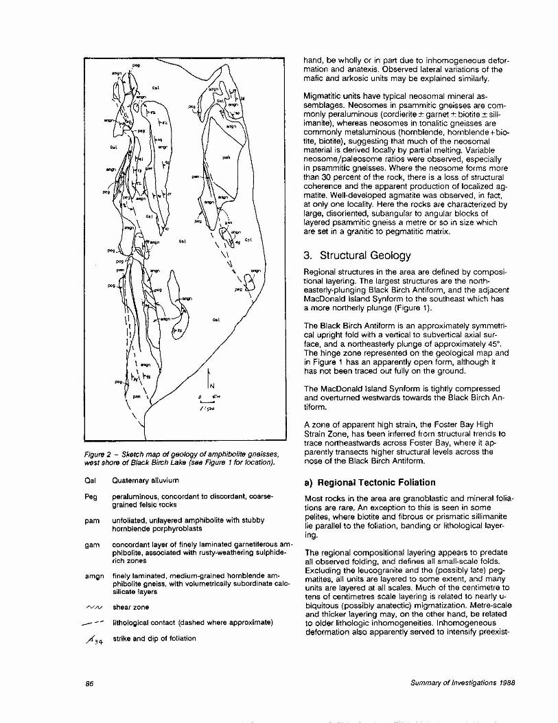
) was mapped at a scale of 1 :500 by Tangeman (Figure 2).
1. Geological Setting Black Birch Lake lies within the Cree Lake Zone of the Churchill Platform (Van Schmus et al., 1987; Lewry and Sibbald, 1977). The Cree Lake Zone is further divided into a number of lithotectonic domains; Black Birch Lake is within the Mudjatik Domain. In contrast to the neighbouring Virgin River and Wollaston Domains, the Mudjatik Domain is characterized by nonlinear structural trends defined by outcrop pattern, foliation and composi· tional layering in (possibly polymetamorphic) upper amphibolite to granulite facies transition gneisses (Lewry and Sibbald, 1977). These rocks have been divided previously into an inhomogeneous package of variably tonalitic to granitic gneisses (the Mudjatik "falsie gneisses") and a volumetrically subordinate package of gneis· ses of probable supracrustal origin {Lewry and Sibbald, 1977, 1980). On the basis of its highly tectonized and mobilized nature, the Mudjatik Domain is thought to have been reactivated during the Trans-Hudson Orogeny; there is, however, only preliminary radiometric evidence to substantiate this so far {see Bickford and others, this volume).
2. Summary of Lithology
The granitic gneisses of Lewry and Sibbald (1977) have been divided by the authors into three units: 1) tonalitic to trondjhemitic gneisses, which probably represent the oldest group, 2) layered granitic augen gneisses, and 3) fine-grained biotite leucogranite. The tonalitic gneisses are variably layered and were probably intruded by a protolith of the layered augen gneiss; unequivocal crosscutting relations were not observed in the Black Birch Lake study area, but were identified in the adjacent lthingo Lake area (C.T. Harper, pers. comm., 1988). The fine-grained leucogranite, which is incipiently foliated, intrudes both the tonalitic gneisses and the granitic augen gneiss, as well as supracrustal units, as slightly discordant, metre-wide apophyses, lenses and sheets.
Rocks of probable supracrustal origin distinguished this summer are similar to those mapped by Lewry and Sibbald {unpublished). Lewry and Sibbald's mafic unit has, however, been divided into three new units. In structural order from the base above the tonalitic and augen gneisses these are:
8) falsie gneisses (possibly metavolcanics), including probable metasedimentary (arkosic) components.
7) mafic to intermediate metavolcanic rocks, with dis· continuous interlayered meta-arkoses; and
6) pelitic gneisses; 5) psammitic to pelitic gneisses, including layered
quartzites; 4) metavolcanic rocks with possible mafic metatuffs,
and garnetiferous anatectites; 3) psammitic to psammopelitic gneisses; 2) metabasalt; 1) psammitic gneisses (at the base); Volumetrically minor pegmatlte dykes are slightly deformed and typically cut compositional layering of country rocks at low angles.
Lateral lithofacies variation is suspected within the supracustal rocks. This is particularly noticeable in the major pelitic unit, which in some localities is a well· defined, strongly layered and highly aluminous rock, whereas in other localities along strike of foliation, it is less well defined, poorly banded and less aluminous. This apparent lithologic variation may, on the other
(1) Aeld support proVlclec:1 uneler tne Saskatchewan component of the Canada- Saskatchewan Subsidiary Agreement on Mlneral Development 1964 - 89, In joint venture wllh the University ol Kansas
(2) Department ol Geology, University ol Kansas, Lawrence, Kansas
84 Summary of Investigations 1988

()
I /
/! 1/ I
I 1 / I I I; I
I !; I I I
I I I I I ~~
Figure 1 - Sketch map of geology of south-central Black Birch Lake area. Symbols: tgn, tonalitic gneisses; gagn, granitic augen gneisses; big, biotite leucogranite; peg, peraluminous and meta/uminous pegmatite; psgn, psammitic gneisses; pgn, pelitic gneisses; mb, metabasalts; agn, amphibolite gneisses; mmv, mafic metavolcanics; qfgn, quartzofeldspathic gneisses.
Saskatchewan Geological Survey 85
p,m
\ \
Figure 2 - Sketch map of geology of amphil:>olite gneisses, west shore of Black Birch Lake (see Figure 1 for location).
Qal Quaternary alluvium
Peg peraluminous, concordant to discordant, coarsegrained felsic rocks
pam unfoliated, unlayered amphibolite with stubby hornblende porphyroblasts
gam concordant layer of finely laminated garnetiferous amphibolite, associated with rusty-weathering sulphiderich zones
amgn finely laminated, medium-grained hornblende amphibolite gneiss, with volumetrically subordinate calcsilicate layers
..-v /V shear zone
- -- lithological contact (dashed where approximate)
,,.(34 strike and dip of fotiation
86
hand, be wholly or in part due to inhomogeneous deformation and anatexis. Observed lateral variations of the mafic and arkosic units may be explained similarly.
Migmatitic units have typical neosomal mineral assemblages. Neosomes in psammitic gneisses are commonly peraluminous (cordierite ±garnet± biotite ± sillimanite), whereas neosomes in tonalitic gneisses are commonly metaluminous (hornblende, hornblende+ biotite, biotite), suggesting that much of the neosomal material is derived locally by partial melting. Variable neosome/paleosome ratios were observed, especially in psammitic gneisses. Where the neosome forms more than 30 percent of the rock, there is a loss of structural coherence and the apparent production of localized agmatite. Well-developed agmatite was observed, in fact, at only one locality. Here the rocks are characterized by large, disoriented, subangular to angular blocks of layered psammitic gneiss a metre or so in size which are set in a granitic to pegmatitic matrix.
3. Structural Geology
Regional structures in the area are defined by compositional layering. The largest structures are the northeasterly-plunging Black Birch Antiform, and the adiacent MacDonald Island Synform to the southeast which has a more northerly plunge (Figure 1 ).
The Black Birch Antiform is an approximately symmetrical upright fold with a vertical to subverticaJ axial surface, and a northeasterly plunge of approximately 45°. The hinge zone represented on the geological map and in Figure 1 has an apparently open form, although it has not been traced out fully on the ground.
The MacDonald Island Synform is tightly compressed and overturned westwards towards the Black Birch Antiform.
A zone of apparent high strain, the Foster Bay High Strain Zone, has been inferred from structural trends to trace northeastwards across Foster Bay, where it apparently transects higher structural levels across the nose of the Black Birch Antiform.
a) Regional Tectonic Foliation
Most rocks in the area are granoblastic and mineral foliations are rare. An exception to this is seen in some pelites, where biotite and fibrous or prismatic sillimanite lie parallel to the foliation, banding or lithological layering.
The regional compositional layering appears to predate all observed folding, and defines all small-scale folds. Excluding the leucogranite and the (possibly late) pegmatites, all units are layered to some extent, and many units are layered at all scales. Much of the centimetre to tens of centimetres scale layering is related to nearly ubiquitous (possibly anatectic) migmatization. Metre-scale and thicker layering may, on the other hand, be related to older Jithologic inhomogeneities. Inhomogeneous deformation also apparently served to intensify preexist-
Summary of Investigations 1988

ing compositional layering, notably in some of the mafic metavolcanics. Details of layering in individual units is described later.
b) Lithological Contacts
From observations of the parallelism of compositional layering, mineral foliation and lithological contacts, lithological contacts in the study area are considered to be tectonically transposed. In two localities, discordance in foliation between lithological units may be explained by slip along the contacts.
c) Folds
The regional tectonic foliation and associated mesoscopic isoclinal folds are deformed by at least two other fold sets. First foliation (F1) and possibly second-generation (F2) folds can be identified at outcrop scale, but possible third-generation folds (F3) are defined by outcrop patterns. Pending further study, all three fold systems are assumed to have been generated during one progressive deformational event.
F1 Folds:
The earliest formed folds recognized consist of mesoscopic isocllnal folds with axial planes lying parallel to foliation. Such folds are seen in all units except the augen gneiss and leucogranite, but are best and most profusely developed in the mafic to intermediate volcanics. In the mafic to intermediate volcanic rocks (unit 7, Table 1), the ratio of amplitude to wavelength is typically on the order of 10: 1, with wavelengths of centimetres to tens of centimetres. Folds of this size and orientation occurring in the mafic metavolcanic rocks are associated with abundant and very small rootless isoclines ("fishhooks"), with a half wavelength of Jess than 1 cm, defined by quartz stringers. The axial planes of the mesoscopic isoclinal folds commonly strike moderately northeast and dip moderately to the southeast.
The mesoscopic F1 folds are probably related to the early megascopic recumbent folds which placed the supracrustal sequence at variable structural levels in the Mudjatik Domain (Lewry and Sibbald, 1977). The MacDonald Island Synform, a large overturned tight asymmetric synform in the eastern part of the area may be one of these earlier megascopic folds. The axis of this synform plunges to the north, probably at a shallow angle, and the axial plane strikes north-northeast and dips steeply to the southeast.
F2 Folds:
Possible second-generation folds recognizable at outcrop scale are much rarer than the first-generation folds. These possible F2 folds are generally asymmetric and much more open than the F1 folds (Figure 3), and the axial planes strike moderately northwest and typically dip steeply to the northeast. In the mafic metavolcanics, possible F2 fold axial planes lie subparallel to small (1 to 5 mm wide) quartz+plagioclase+chlorite veins. These veins have a minimum spacing about 40 cm, and at
Saskatchewan Geological Survey
least some of them have accommodated slip, as in many instances compositional layering cannot be traced across the veins.
Possible F3 Fold:
The regional-scale Black Birch Antiform, which is defined at low structural levels by compositional layering, may be a product of third-generation folding.
d) Mineral Lineation
Mineral lineations have been observed on the west limb of the MacDonald Island Synform in the south-central part of the study area, and were most commonly encountered on foliation surfaces in the felsic and mafic to intermediate metavolcanic rocks. The lineation is most commonly defined in the mafic metavolcanic rocks by the parallel alignment of hornblende grains, and in the felsic metavolcanic rocks by parallel alignment of elongate streaks of medium-grained biotite. These mineral lineations do not typically lie parallel to the F1 fold recorded nearby, or to the axes of major folds deduced from map patterns.
e) Secondary Cleavage
A north-striking, steeply dipping secondary cleavage (Figure 4) was recognized in a few outcrops of psammitic gneiss and tonalitic gneiss in the central part of the study area. This cleavage consists of spaced zones of finite width, spatially associated with the thinned steep limbs of asymetric harmonic folds. The spacing of these cleavage zones varies from 2 to 30 cm, with an average of about 25 cm. The width of individual zones varies varies from much less than 1 cm to about 5 cm; the widest appear to contain aplite or granite probably derived by recrystallization of country rock. Many cleavage zones have truncated and offset the preexisting layering. All unequivocally observed offsets are left. lateral, with apparent offsets ranging from less than
Figure 3 - Simplified sketch of refolded folds in mafic metavo/canics. Stippled areas represent amphibolite layers, solid areas represent homblenditfl layers, unpattemed areas represent quartz-plagioclase layers. Bold solid lines represent D 1
fold axial traces and broken lines represent 0 2 fold axial traces. Hamfrlf1r for scale.
87

Figure 4 - Simplified sketch of secondary cleavage in well· layered psammitic gneiss, north--central 02. Stippled area rep· resents slightly discordant coarse-grained quartz vein. Layer· ing defined by relative abundances of quartz and K·feldspar. Lens cap for scale.
1 cm to about 25 cm. Amplitudes of the associated asymmetric folds show a similar dimensional range. The orientation of the cleavage zones varies somewhat in outcrop, and they even intersect each other at low angles in some places. Individual zones are discon· tinuous and heterogeneous, even at very small scales.
The relative age of this cleavage.forming event is not well understood, other than the fact that it is younger than the foliation and older than or coeval with the mig· matization.
f) Putative Fault or Shear Zone
Layering in the lower structural levels of the Black Birch Antiform is not parallel to layering in the psammitic gneisses at higher structural levels. In fact, the layering in the psammitic gneisses does not relate to the antiformal structure, but rather consistently strikes north to northeast and dips easterly to southeasterly. This structural incongruency cannot be explained solely by an of· fset of the latest fold axial trace at the crossing of an ear· lier axial trace because of the absence of the northwestdipping layering to the west. A fault or shear zone may have either reoriented the layering or simply juxtaposed orientations from different parts of the fold. If real, this structure would be expected to strike approximately northeast. Its presence may account for the anomalous dips in quartzite, the generally more aluminous and migmatitic nature of the rocks to the west relative to those to the east, and for such topographic features as asymmetric ridges. Presumably, the throw on such a structure need not be very great, since it does not apparently juxtapose units from greatly different parts of the structural sequence. The proposed structure must be considered highly conjectural, since field evidence for faulting or shearing is lacking.
88
4. Descriptions of Units
a) Tonalitic Gneisses
The tonalitic gneisses are typically low or lacking in Kfeldspar, fine to medium grained, granoblastic and moderately to very well layered. The most common as· semblage is plagioclase +quartz+ biotite, but both Kfeldspar- and hornblende-bearing bands exist. Neither magnetite nor orthopyroxene has been detected in this unit. Compositional layering is locally irregular and nebulous, but overall is well defined by the relative abundance of mafic minerals. In rare cases, a mineral foliation is defined by the parallel alignment of biotite grains within one layer to each other and to compositional layering.
Larger scale layering (tens of metres) is defined, in part, by relatively thin and laterally discontinuous zones of mafic enclaves. In highly strained rocks on the limbs of major folds, these zones occur as concordant layers carrying aligned elongate blocks of biotite schist or amphibolite. In these areas, foliations in the mafic enclaves are parallel to the local orientation of the regional tectonic foliation. Zones found near the hinges of major structures are still regionally concordant, but the blocks tend to be rounded or angular, and internally massive. The shapes of these blocks do not suggest that they are the fractured remains of a once-continuous layer.
Other mafic zones in tonalitic gneisses are clearly representative of disrupted planar features. The most common of these are 2 to 10 cm thick boudinaged granoblastic amphibolites (accompanying map). One sample of tonalitic gneiss was collected for zircon geochronologic analysis.
b) Augen Gneiss
This unit is brick-red, foliated, moderately well layered, coarse grained and porphyroclastic, and probably represents a deformed porphyritic granite. Layering is defined by relative grain size and abundance of augen; thin (1 to 4 cm wide), fine- to medium.grained equigranular layers separate thicker (metre-wide) layers of coarsegrained K-feldspar and plagioclase augen-rich rock. Plagioclase augen are less abundant and generally smaller than the K-feldspar augen, which are typically 1 to 2 cm long. Metre-wide alkali-feldspar granite pegmatite dykes are locally abundant, commonly cut layering, and may represent locally derived anatectic melts from the augen gneiss itself. Pegmatite dykes with such abundant K-feldspar are rarely found outside the augen gneiss. The borders of some of these dykes are coarser grained than the cores. Much of the layering may be related to intrusion of leucogranite (discussed below). One sample of augen gneiss was collected for zircon geochronologic analysis.
c) Biotite Leucogranite
Biotite leucogranite is pale pinkish-grey, with weathering colours ranging from orange to brown. The rock is fineto medium-grained, equigranular, and locally exhibits an
Summary of Investigations 1988

incipient foliation defined by parallel alignment of biotite grains. This foliation is broadly parallel to the regional tectonic foliation in the county rock. However, the leucogranite bodies (of probable sheet-like form) are generally slightly discordant to country-rock foliation, as evidenced by the truncation at low angles of those foliations by the leucogranite. Apophyses of leucogranite in tonalitic gneiss, augen gneiss and psammitic gneiss are also commonly slightly discordant. At one locality, a 50 cm thick dyke of leucogranite is apparently intruded along the contact between the augen gneiss and the tonalitic gneisses. At this outcrop, considerable apparent discordance (15° to 20") of the dyke to layering in the augen gneiss can be observed, although not in the tonalitic gneiss. Apophyses of leucogranite in augen gneiss are ptygmatically folded. Some of the centimetrewide, fine-grained concordant granitic veins in the augen gneiss can be traced into metre-wide and slightly discordant dykes of leucogranite. Two samples of biotite leucogranite were collected for zircon geochronologic analysis.
d) Psammitic and Psammopelitic Gneisses
Psammitic to psammopelitic gneisses are a heterogeneous group and include quartzofeldspathic gneisses, biotite gneisses and schists, quartzites, nearly massive meta-arkoses and very minor iron formation. These gneisses appear at various structural levels within the sequence and vary little from one level to the next.
Layered quartzofeldspathic gneisses, the most abundant variety, are most commonly fine grained and pink, grey, or white in outcrop. Some quartzites have both brick-red and yellow layers. The biotite gneisses are dark grey. Features observed more commonly in psammitic gneisses than in other units include 1) large and abundant cordierite crystals up to 20 cm long and abundant cordierite grains (commonly cored with sillimanite) in pods of anatectic melt, 2) kink-folds and secondary cleavages, 3) tourmaline pegmatites, and 4) faserkiesel. Muscovite appears only in the quartzofeldspathic gneisses or derived anatectic melts and, although locally abundant, is probably a retrogressive development because individual muscovite grains lie throughout at high angles to foliation in compositional banding.
One sample of probable iron formation and one sample of quartzofeldspathic gneiss were collected for possible geochronologic analysis of detrital zircon.
e) MetabasaH
Metabasalt forms a relatively thin unit a few metres thick. Exposures have been found only at and near the hinge of the Black Birch Antiform. The unit is distinct from other mafic units in its fine-grained texture, finely laminated (millimetre-scale) mineral layering, and complete lack of larger scale layering. Outcrops at the hinge of the Black Birch Antiform are composed entirely of black and compositionally homogeneous amphibolite. A few hundreds of metres away from the hinge, and probably at a slightly different structural level, both diopside and quartz are present in low abundance as millimetre-scale discontinuous lenses. Possible relict pillow
Saskatchewan Geological Survey
structures occur at this locale. These structures are formed by discontinuous, centimetre-wide arcuate plagioclase+quartz±diopside layers. In two dimensions, these layers enclose low-aspect ratio elliptical areas which cannot be related to local foliation or folding of foliation. Such layers are typically isolated from each other and rare overall.
f) Mafic Metatuffs and Metavolcanic Rocks
This unit is characterized by dark grey amphibolite, consisting primarily of fine-grained equigranular granoblastic hornblende, plagioclase and diopside. This amphibolite is generally finely laminated with alternating plagioclase-rich and hornblende-rich layers; hornblendite layers 4 to 6 cm wide are less abundant. Hornblendite-bounded quartz layers and lenses are dispersed throughout this unit, but are markedly less abundant overall than in the second mafic metavolcanic sequence (unit 7, Table 1). Some of the quartz layers exhibit pinch-and-swell structure. Plagioclase, diopside, hornblende and orthopyroxene are commonly included in the quartz lenses and layers.
Three mineralogically distinct subunits were observed in this unit:
Garnetiferous Amphibolite: Layers of 1 to 2 cm thick garnetiferous amphibolite are quite common. The garnetiferous amphibolite is associated with rusty-weathering sulphide zones, in which small garnet grains are abundant.
Porphyritic Amphibolite: Unfoliated porphyritic amphibolite consists of stubby hornblende porphyroblasts (typically less than 1 cm in diameter) in a granoblastic hornblende+ plagioclase matrix. These layers are typically 1 to 4 m thick, and display rare relicts of pillow structure in the form of poorly defined arcuate diopside + plagioclase bands. The bulk of the unit may have derived from tuffaceous rocks.
Peraluminous Dykes: This subunit consists of coarsegrained and possibly anatectic peraluminous layers composed of K-feldspar +quartz+ sillimanite + cordierite + garnet+ biotite. Some layers of this approximate composition are concordant, whereas others are discordant and appear to have intruded along shear zones of small offset. Orthopyroxene was found in the amphibolite adjacent to contacts of some of these dykes, suggesting that intrusion of the dykes caused dehydration of the country rocks.
Four samples from this unit were collected for geochronologic analysis: one sample of concordant and one of discordant peraluminous rock, one of porphyritic amphibolite and one of the finely laminated amphibolite.
g) Pelitic Gneiss
This unit is well layered and foliated. The most abundant rock type is yellow-grey to white, coarse- to very coarse-grained gneiss composed of plagioclase + garnet+ biotite +quartz+ sillimanite + cordierite + K-feldspar. Subordinate rock types include black, fine-grained, gar-
89

net-bearing biotite schist, and greenish- or bluish-grey, very fine grained cordierite gneiss. Thin, discontinuous rusty-weathering zones are common and typically include pyrite and graphite. The pelitic gneisses are generally much coarser-grained and, in general, exhibit a lower abundance of anatectic melt than the psammitic gneisses in the same area, although very minor Kfeldspar-rich pods can be found. Given the higher melting temperature of aluminous bulk compositions, this relationship supports the earlier suggestion of very local derivation of much of the melt observed. One rustyweathering sulphide-bearing zone was sampled for sulphide lead isotopic analysis.
h) Mafic to Intermediate Metavolcanic Rocks
The mafic to intermediate volcanics are composed primarily of mineralogicaUy variable amphibolites with very subordinate felsic material (typically quartz+ plagioclase), calc-silicates and hornblendites. The feature which distinguishes this unit from other mafic units in the area is the high abundance of small, typically 1 to 15 mm wide, isoclinally folded quartz lenses and stringers ("fishhooks"). Amphibolites are typically dark greenish-grey, granoblastic and compositionally laminated at the millimetre scale. Diopsidic amphibolites are not layered, but have a foliation defined by millimetre-thick diopside lenses, most commonly mantled by equally thin rims of plagioclase, in a hornblende+ plagioclase matrix. Hornblendite occurs as thin discontinuous layers and as discrete irregular clots within diopside and hornblende amphibolites. Cale-silicate layers in these amphibolites are typically composed of diopside + plagioclase. Garnet is a rarer accessory and orthopyroxene is rarer still. No vestiges of any primary volcanic structures, such as pillows, were observed.
Discontinuous interlayers of fine-grained, biotite-poor, nearly massive meta-arkose are more common within this unit than elsewhere and underscore the interpreted supracrustal origin of the unit. These layers range from less than one to several metres thick, and are characterized by centimetre-wide, irregular, coarse-grained quartz-plagioclase veins.
i) Quartzofeldspathic Gneiss (Possibly Felsic Metavolcanic Rock)
These rocks consist primarily of layered gneisses which contain variable quantities of quartz, plagioclase, Kfeldspar and biotite. Falsie metavolcanic rocks are superficially similar to the tonalitic gneisses; however, the generally higher percentage of K-feldspar and lack of hornblende in the former serve to distinguish the two units. A volcanic protolith for this unit is suggested on the basis of its spatial association with the metasupracrustal sequence (a juxtaposition which is possibly entirely structural), and on the abundant, spaced (metres to tens of metres apart), subplanar zones of mafic enclaves. These discontinuous zones are parallel to the regional tectonic foliation and, as in the tonalitic gneisses, are thought to represent disrupted preexisting planar features such as sills, or intercalated flows in a volcanic or sedimentary pile. In the felsic metavolcanic rocks, these zones are not thought to represent dykes,
90
as they are rare or absent in the remainder of the supracrustal sequence.
Layering, defined by relative abundance of biotite in the falsie metavolcanic rocks, varies from nearly nonexistent to well developed. Where layering is nearly nonexistent, the rock strongly resembles a somewhat deformed, equigranular granite; however, such rocks can be traced without break into rocks with well-developed layering. The felsic metavolcanic rocks are exposed entirely within the core of an isoclinal synform, so much of this variation is probably related to inhomogeneous deformation. Additionally, K-feldspar-bearing parts of the unit have compositions which resemble minimum melt compositions and may therefore represent stages in the process of rehomogenization by melting. Two samples of this unit were collected for zircon geochronologic analysis.
j) Pegmatite Dykes
Two examples of two types of felsic dyke were encountered: 1) aluminous biotite granite pegmatite and 2) granitic (peraluminous) pegmatite. The aluminous dykes contain garnet, biotite, relatively common tourmaline, sillimanite and cordierite; magnetite is locally both very abundant and coarse grained. The dykes are 10 to 20 m wide and can be traced for several tens of metres along strike. All four dykes are subconcordant with foliation in the country rock, and two of them carry large blocks of local country rock which are also subconcordant. Deformed fractured grains and incipient mineral foliation occur in all dykes, which are, in general, only weakly deformed.
As with neosomes of the migmatites, the mineral composition of these pegmatites appears to be related to the adjacent country rock; the aluminous pegmatites are associated with psammopelitic gneiss, whereas the granitic pegmatites are associated with quartzofeldspathic gneiss and/or amphibolite. This observation, coupled with the discontinous nature of the dykes, suggests that these pegmatites were possibly also locally derived by partial melting, but during times of waning deformation, when melt fractions were able to coalesce into slightly larger discordant bodies. Two pegmatite samples were collected for zircon geochronological analysis.
5. Metamorphism The peak metamorphic conditions indicated by mineral assemblages in these rocks are in the upper amphibolite/granulite facies transition, as evidenced by the abundance of migmatites, by the presence of prismatic sillimanite in probable textural equilibrium with Kfeldspar, and by the restricted occurrence of muscovite. Relatively low pressures (probably less than 5 kilobars) are suggested but not required by the absence of kyanite and the abundance of cordierite. High temperatures must have been reached before or at the time the F1 folds were formed, because neosomes of migmatitic units are commonly isoclinally folded. Individual bent sillimanite grains were also observed in probable F1 folds,
Summary of Investigations 1988

but it is not clear about which orientation they were folded. That high temperatures may have persisted past the time of deformation is suggested by the granoblastic nature of much of the rock and by the observation of garnet and other minerals growing across compositional layering.
6. Projected Studies
It is hoped that geochronologic study will:
1) identify the oldest rocks in the area; 2) demonstrate whether protoliths of the tonalitic and
augen gneisses are significantly older than protoliths of the metasupracrustal sequence;
3) constrain the duration of the sedimentary cycle that produced the supracrustal sequence;
4) demonstrate whether or not the protoliths of the supracrustal rocks are known units in the Mudjatik Domain; and
5) determine the age (or ages) and duration of metamorphic and deformational events.
Whole-rock geochemical study of rocks with probable igneous precursors should serve to constrain possible tectonic settings at the time of melting, as well as potential pressure-temperature conditions at the time of emplacement. Additionally, it may be possible to identify the sources of the neosomes of the migmatites and of the pegmatite dykes. Mineral chemical study of metamorphic assemblages is proposed in order to determine the sense and position in P-T space of the pressuretemperature-time path of the metamorphic event(s). The pressure-temperature-time path should yield a great deal of information about the sequence of orogenic events.
Saskatchewan Geological Survey
7. Acknowledgments
The authors would like to thank C.T. Harper for in-field training, advice and support. R. Macdonald, K.D. Collerson, C.T. Harper and J.F. Lewry made significant contributions to the interpretations presented here; however, the authors take full responsibility for any errors in judgement. S.E. Orrell would particularly like to acknowledge the special assistance of the owner, Mr. Dennis O'Brien, and staff of Buffalo Narrows Airways, who went out of their way to make our field time safer and more comfortable. Financial support for this research was provided by Saskatchewan Energy and Mines and by the U.S. National Science Foundation (grant #EAR-8719997).
8. References
Lewry, J.F. and Sibbald, T.1.1. (1977): Variation in lithology and tectonometamorphic relationships in the Precambrian basement of northern Saskatchewan; Can. J. Earth Sci., v14, p1453-1467.
-~-- (1980): Thermotectonic evolution of the Churchill Province in northern Saskatchewan; Tectonophysics, v68, p45-82.
Sibbald, T.1.1. (1973): 74-B-NW: Mudjatik (nw); in Summary Report of Geological Investigations Conducted in the Precambrian Alea of Saskatchewan; Sask. Dep. Miner. Resour., p35-42.
Thomas, M.W. (1984): Compilation bedrock geology: Mudjatik area (NTS 748); 1:250,000 scale prelim. map with Summary of Investigations 1984, Sask. Geol. Surv., Misc. Rep. 84-4.
Van Schmus, W.R., Bickford, M.E., Lewry, J.F. and Macdonald, R. (1987): U-Pb geochronology in the Trans-Hudson Orogen, northern Saskatchewan, Canada; Can. J. Earth Sci., v24, p407-424.
91
