geology of the freshwater bay area chichagof island, alaska · · 2011-06-27geology of the...
TRANSCRIPT
Geology of the Freshwater Bay Area Chichagof Island, AlaskaBy ROBERT A. LONEY, WILLIAM H. CONDON, and J. THOMAS DUTRO, JR,
MINERAL RESOURCES OF ALASKA
GEOLOGICAL SURVEY- BULLETIN 1108-C
General geology of an area underlain largely by middle Paleozoic rocks, with emphasis on stratigraphy, structure, and petrography
UNITED STATES GOVERNMENT PRINTING OFFICE, WASHINGTON : 1963
UNITED STATES DEPARTMENT OF THE INTERIOR
STEWART L. UDALL, Secretary
GEOLOGICAL SURVEY
Thomas B. Nolan, Director
For sale by the Superintendent of Documents, U.S. Government Printing Office Washington 25, D.C.
CONTENTS
PageAbstract______..._______._____-__---___--__.--------_-____---__ ClIntroduction....._________________________________________________ 2
Previous investigations.________________________________________ 4Purpose and scdpe__.__________--_-___---___---_--__-_________- 5
Bedded rocks____________________-_-_-_________-_-_-_._____.______ 6i Silurian (?) or Devonian (?) rocks.______________________________ 6
Unnamed argillite and graywacke__._________-__-_._--____ 6Distribution and topographic expression._________________ 6Stratigraphy and petrography _______________________ 8
False Bay area_-_-----------------__--_------__-_- 8Southwest of Freshwater Bay____---_---_-_________- 11
, Conglomerate at East Point______________________ 12Age and correlation_______-_-_-_-_-_-_-_--_____________ 13
' Devonian rocks.______________________________________________ 13Kennel Creek limestone.------------------------------.---- 13
Distribution and topographic expression._________________ 13Stratigraphy. _________________________________________ 14Age and correlation____-____-_-_-_-_-_-___-_-__________ 16
Cedar Cove formation___________________________________ 17Distribution and topographic expression________________ 17Stratigraphy and petrography ________________________ 18Age and correlation____-_-----_--_-_---_-_--______-_-__ 22
Freshwater Bay formation________________________________ 23Distribution and topographic expression________________ 23
' Stratigraphy and petrography-------..------------.-__--.._._ 23Southwest limb of Freshwater Bay syncline________ 24
Lower greenstone member....___________________ 24Middle rhyolitic member____________________ 25Upper andesitic member._______________________ 28
Northeast limb of Freshwater Bay syncline_________ 29Age and correlation.____-_--_-____._---________________ 31
Mississippian rocks__.______________________________________ 32lyoukeen formation______-----_--_-._-_-__--_______---__ 32
Distribution and topographic expression._________________ 32Stratigraphy and petrography.________________________ 32Gypsum deposits___-__-_-_-_-___-_-_-_.____._._____ 34Measured sections___________________________________ 34Age and correlation____---_--_--__._-_-_--_________-___ 36
j Quaternary deposits..___-________--_-----___-_--______-__________ 37in
IV CONTENTS
Page Intrusive igneous rocks-_-_-___----_____-__---_-_____-_______--_____ C37
Gypsum Creek quartz monzonite________________________________ 38Distribution and location____.______________________________ 38Petrography______________________________________________ 39Contact metamorphism__--_____-__________-_______________ 40
Pluton at the head of Kennel Creek.____________________________ 40Contact metamorphism__-_________________________________ 41
Small plutons._-__---_---------_--_---------_-------------____ 42Dikes and sills_-___---_----_-__----_---____-----____-_________ 43
Andesite dikes and sills ________________ ___________ 43Spessartite lamprophyre __--___-__-_---_-____-____.______ 44
Structure.--..--- ___.______--- ______________________________ 45Freshwater Bay syncline.__-----_____---______-_-______________ 45Faults and lineaments________________________________________ 45
Eastward-striking faults and associated lineaments ____________ 46Northwestward-striking faults and associated lineaments _______ 46Northwestward-striking thrust faults_______________________ 47Marginal thrust faults near intrusive bodies _______________ 48
Geologic history________-_____-_----_-____--_-__----.__---_-_--_-__ 48Literature cited.__________________________________________________ 51Index.__________.________________________________ 53
ILLUSTRATIONS[Plates In pocket]
Page1. Geologic map and sections of the Freshwater Bay area.2. Correlated composite stratigraphic sections.
FIGURE 1. Index map of southeastern Alaska.________________________ 02
TABLES
Page TABLE 1. Composite section for the Freshwater Bay area____________ C7
2. Summary of plutonic igneous bodies in the Freshwater Bayarea... __ _____ ____________._____ 38
MINERAL RESOURCES OF ALASKA
GEOLOGY OF THE FRESHWATER BAY AREA CHICHAGOF ISLAND, ALASKA
By ROBERT A. LONEY, WILLIAM H. CONDON, and J. THOMAS DUTRO, JR.
ABSTRACT
The Freshwater Bay area comprises about 140 square miles in the northeast ern part of Chichagof Island, southeastern Alaska. A sequence of Paleozoic rocks more than 24,000 feet thick is divided into 5 formations, 4 of which are named for the first time. From the base upward the units are: unnamed argil- lite and graywacke (Silurian (?) or Devonian (?)), which are more than 5,000 feet thick; Kennel Creek limestone (Middle Devonian), which consists of fos- siliferous limestone that averages about 3,500 feet thick; Cedar Cove formation (Middle and Upper (?) Devonian), which consists of graywacke, argillite, con glomerate, and fossiliferous limestone that are about 2,600 feet thick; Freshwater Bay formation (Upper Devonian), which consists of greenstone, rhyolite and andesite flows, pyroclastic rocks, and associated sedimentary rocks that are about 6.500 feet thick; and lyoukeen formation (Mississippian), which consists of fos siliferous cherty limestone and shale that are about 4,500 feet thick.
A possible unconformity lies between the unnamed argillite and graywacke and the overlying Kennel Creek limestone. Unconformities occur both at the base and at the top of the Freshwater Bay formation.
Five deep-seated plutonic bodies intrude the Paleozoic sequence. Their age can be determined no closer than post-Late Mississippian and pre-Quaternary. Two of the five plutons are 4 square miles or more in area and are quartz mon- zonitic to granitic in composition. The remaining 3 are less than 1 mile square and are dioritic to quartz dioritic in composition. The plutons have abrupt borders and narrow contact aureoles. Near the unit here named the quartz monzonite, minor marginal thrust faults in the surrounding country rock are directed away from the intrusive body at high angles.
"At some time after the deposition of the lyoukeen formation and before the deposition of the Quaternary unconsolidated deposits, the Paleozoic rocks were folded into a major southeastward-plunging syncline. Folding was followed by igneous intrusion and the development of a fault system. A tentative order of events, after the initiation of folding, is: (1) eastward-striking left-lateral fault ing; (2) plutonic intrusion accompanied by marginal thrust faulting; (3) north westward-striking, right-lateral faulting; (4) southwestward-directed thrust faulting.
Cl
C2
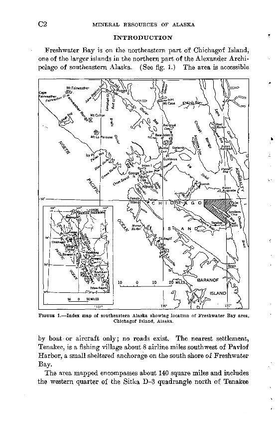
Freshwater Bay is on the northeastern part of Chichagof Island, one of the larger islands in the northern part of the Alexander Archi pelago of southeastern Alaska. (See fig. 1.) The area is accessible
FIGURE 1. Index map of southeastern Alaska showing location of Freshwater Bay area,Chichagof Island, Alaska.
by boat or aircraft only; no roads exist. The nearest settlement, Tenakee, is a fishing village about 8 airline miles southwest of Pavlof Harbor, a small sheltered anchorage on the south shore of Freshwater Bay.
The area mapped encompasses about 140 square miles and includes the western quarter of the Sitka D-3 quadrangle north of Tenakee
GEOLOGY OF THE FRESHWATER BAY AREA C3
Inlet and the northern two-thirds of the Sitka D^t quadrangle. The southwestern limit of mapping extends from a point on Tenakee Inlet about 2 miles southwest of East Point northwest to a point about 8 miles south of the northwest corner of the Sitka D-4 quadrangle. About one-sixth of the Freshwater Bay area as denned is covered by water.
Major topographic features show a strong northwestward orienta tion, which is a direct expression of the structure of the underlying rocks. Most prominent of these features is Freshwater Bay, which extends from Chatham Strait northwestward for about 13 miles. Al though about 21/2 miles wide at its mouth, this feature tapers to less than half a mile wide at its head. A low broad valley continues the trend of Freshwater Bay northwestward to the western border of the map.
Freshwater Bay is surrounded by mountainous terrain, composed chiefly of long rounded northwestward-trending ridges with some shorter transverse northeastward-trending ridges. The ridges aver age about 2,000 feet in altitude with several peaks reaching above 3,000 feet. The highest point in the area, with an altitude of 3,395 feet, is on the first ridge north of the head of the bay. Here also is the maximum relief, because the southern slope of the ridge rises directly from sea level.
Stream valleys are generally narrow with the exception of the broad valley at the head of Freshwater Bay, in which the North Fork of Freshwater Creek flows, and the valley of lyouktug Creek near the northeast corner of the map area. All the major valleys are U-shaped, indicating former valley glaciation, and the valleys of Pavlof River, Kennel Creek, and Seal Creek, entering Freshwater Bay, appear to be hanging about 100 feet above sea level.
Freshwater Bay, along with southeastern Alaska in general, has a mild climate and abundant precipitation. Because no weather sta tions are located either within the area or in adjacent northeastern Chichagof Island, the climatic summary below is taken from. U.S. Weather Bureau data recorded at Angoon, Admiralty Island, about 30 airline miles to the southeast, and at Juneau, about 35 airline miles to the northeast. Although these stations lie outside the immediate vicinity of the Freshwater Bay area, both are at sea level and in gen eral the data from them indicate the climate to be expected within the region.
Precipitation is distributed rather evenly throughout the year with September, October, and November receiving the greatest amount and May, June, and July receiving the least.
C4 MINERAL RESOURCES OF ALASKA
Average precipitation, in inches, for the years 1931-55
Station
Juneau ...........Angoon.... ......
Jan.
7. IS4.81
Feb.
5.633.95
Mar.
5.412.88
Apr.
5.462.92
May
5.222.52
June
3.952.10
July
5.033.25
Aug.
7.332.96
Sept.
10.156.29
Oct.
11.187.42
Nov.
9.105.66
Dec.
7.614.92
An nual
83.2550.68
Summers are cool and winters mild for this latitude as indicated by the summary as follows:
Temperature summary, in degrees Fahrenheit, for the years 1981-65
Station
Juneau _ ______________ _____
January average
27.528.4
July average
56.655. 1
Absolute maximum
8984
Absolute minimum
-15-10
Annual mean
42. 240. 7
The Freshwater Bay area is heavily forested except for the tops of the higher ridges. Western hemlock and Sitka spruce dominated the dense vegetation below timberline, which ranges from 1,500 to 2,000 feet in altitude. Above timberline, lichens, sedges, mosses, and scattered shrubs replace the taller vegetation of the lower al titudes.
PREVIOUS INVESTIGATIONS
Most of the contributions to the geology of the Freshwater Bay area were published before 1912. Since that time, and until the present work was undertaken, field investigations have been confined largely to the gypsum deposits at lyoukeen Cove.
Prior to 1912, C. W. and F. E. Wright made extensive recon naissance explorations in southeastern Alaska. Kesults of these in vestigations, published in Brooks and others (1906, 1907, and 1908), contain reconnaissance geologic maps of southeastern Alaska in cluding the shorelines of the Freshwater Bay area. The reports, mostly by C. W. Wright, deal largely with the gypsum deposits at lyoukeen Cove but also contain comments on the geology of the rocks adjacent to the deposits.
The first definitive work on the rocks of the Freshwater Bay area (Kindle, 1907, p. 314r-337) presents lists of fossils collected from strata at Freshwater Bay together with brief lithologic descriptions and age correlation. The paper was based on a reconnaissance of the area by Kindle and C. W. Wright in the summer of 1905.
Knopf reported briefly on the rocks along the north coast of Chich- agof Island (1912, p. 11,12).
GEOLOGY OF THE FRESHWATER BAY AREA C5
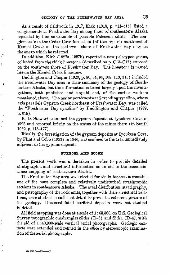
As a result of fieldwork in 1917, Kirk (1918, p. 511-515) listed a conglomerate at Freshwater Bay among those of southeastern Alaska regarded by him as example of possible Paleozoic tillite. The con glomerate in the Cedar Cove formation (of this report) northwest of Kennel Creek on the southwest shore of Freshwater Bay may be the one to which he referred.
In addition, Kirk (1927a, 1927b) reported a new pelecypod genus, collected from the thick limestone (described on p. C13-C17) exposed on the southwest shore of Freshwater Bay. The limestone is named herein the Kennel Creek limestone.
Buddington and Chapin (1929, p. 80, 84, 94,108,110, 315) included the Freshwater Bay area in their summary of the geology of South eastern Alaska, but the information is based largely upon the investi gations, both published and unpublished, of the earlier workers mentioned above. The major north westward-trending syncline, whose axis parallels Gypsum Creek northeast of Freshwater Bay, was called the "Freshwater Bay syncline" by Buddington and Chapin (1929, p.315).
B. D. Stewart examined the gypsum deposits at lyoukeen Cove in 1928 and reported briefly on the status of the mines there (in Smith 1932, p.173-177).
Finally, the investigation of the gypsum deposits at lyoukeen Cove, by Flint and Cobb (1953) in 1946, was confined to the area immediately adjacent to the gypsum deposits.
PURPOSE AND SCOPE
The present work was undertaken in order to provide detailed stratigraphic and structural information as an aid to the reconnais sance mapping of southeastern Alaska.
The Freshwater Bay area was selected for study because it contains one of the most complete and relatively undisturbed stratigraphic sections in southeastern Alaska. The areal distribution, stratigraphy, and petrography of the rock units, together with their structural rela tions, were studied in sufficient detail to present a coherent picture of the geology. Unconsolidated surficial deposits were not studied in detail.
All field mapping was done at a scale of 1: 63,360, on U.S. Geological Survey topographic quadrangles Sitka (D-3) and Sitka (D-4), with the aid of 1:40,000-scale vertical aerial photographs. Geologic con tacts were extended and refined in the office by stereoscopic examina tion of the aerial photographs.
648927 63-
C6 MINERAL RESOURCES OF ALASKA
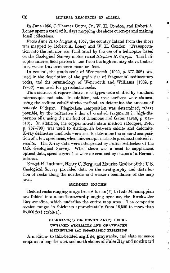
In June 1956, J. Thomas Dutro, Jr., W. H. Condon, and Robert A. Loney spent a total of 21 days mapping the shore outcrops and making fossil collections.
From June 21 to August 4,1957, the country inland from the shore was mapped by Robert A. Loney and W. H. Condon. Transporta tion into the interior was facilitated by the use of a helicopter based on the Geological Survey motor vessel Stephen R. Capps. The heli copter carried field parties to and from the high country above timber- line, where traverses were made on foot.
In general, the grade scale of Wentworth (1922, p. 377-392) was used in the description of the grain size of fragmental sedimentary rocks, and the terminology of Wentworth and Williams (1932, p. 19-53) was used for pyroclastic rocks.
Thin sections of representative rock types were studied by standard microscopic methods. In addition, cut rock surfaces were stained, using the sodium cobaltinitrite method, to determine the amount of potassic feldspar. Plagioclase composition was determined, where possible, by the refractive index of crushed fragments in high-dis persion oils, using the method of Emmons and Gates (1948, p. 612- 618). In addition, the copper nitrate stain method (Rodgers, 1940, p. 787-798) was used to distinguish between calcite and dolomite. X-ray def raction methods were used to determine the mineral composi tion of a few specimens, when microscopic methods produced indecisive results. The X-ray data were interpreted by Julius Schlocker of the U.S. Geological Survey. When there was a need to supplement optical data, specific gravities were determined by means of a Berman balance.
Ernest H. Lathram, Henry C. Berg, and Maurice Grolier of the U.S. Geological Survey provided data on the stratigraphy and distribu tion of rocks along the northern and western boundaries of the map area.
BEDDED ROCKS
Bedded rocks ranging in age from Silurian (?) to Late Mississippian are folded into a southeastward-plunging syncline, the Freshwater Bay syncline, which underlies the entire map area. The composite section ranges in thickness approximately from 18,500 to more than 24,000 feet (table 1).
SILUBIAN(P) OR DEVONIAIT(P) BOCKS
UNNAMED ARGILLITE AND GBAYWACKB
DISTRIBUTION AND TOPOGRAPHIC EXPRESSION
A medium- to thin-bedded argillite, gray wacke, and slate sequence crops out along the west and north shores of False Bay and northward
GEOLOGY OF THE FRESHWATER BAY AREA C7
along Chatham Strait at the northeast corner of the map area. These rocks form a continuous belt, about 1 to 2 miles wide, that stretches along the northeast coast of Chichagof Island from Chatham Strait northwestward to the entrance of Port Frederick, a distance of about 22 miles.
The argillite and graywacke sequence underlies an area of diverse topography including low, broad valleys and, locally, high ridges. The lowlands are underlain largely by argillite, whereas the ridges are composed of interbedded graywacke and argillite.
Argillite, graywacke, and conglomerate form discontinuous ex posures along the southwest border of the map area. These rocks, tentatively correlated with the clastic sequence at False Bay, are poorly known owing to lack of exposures and structural complexity resulting from the emplacement of the large pluton in the drainage area of Pavlof Biver and Kennel Creek.
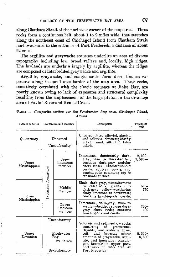
TABLE 1. Composite section for the Freshwater Bay area, Chichagof Island,Alaska
System or series
Quaternary
Upper Mississippian
Lower Mississippian
Upper Devonian
Formation and member
Unnamed
Unconformity
lyoukeen formation
Upper limestone member
Middle member
Lower limestone member
Unconformity
Freshwater Bay
formation
Unconformity
Description
Unconsolidated alluvial, glacial, and colluvial deposits; chiefly
. gravel, sand, silt, and talus debris.
Limestone, dominantly dark- gray, thin to thick-bedded; contains dark-gray nodular chert lenses; lithostrotionoid corals, solitary corals, and brachiopods common; top is erosional surface.
Shale, dark-gray, noncalcareous to calcareous; grades into dark-gray yellow-weathering shaly limestone to northwest; contains brachiopods, corals.
Limestone, dark-gray, thin- to medium-bedded; sparse dark- gray chert beds; contains brachiopods and corals.
Volcanic and sedimentary rocks consisting of greenstone, rhyolite, and andesite flows, tuff, and breccia; minor amounts of graywacke, argil lite, and limestone; brachio- pod faunule in upper part, northwest of map area at Port Frederick.
Thickness (feet)
2,000- 3,500
500- 750
200- 600
5, 000- 6,500
G8
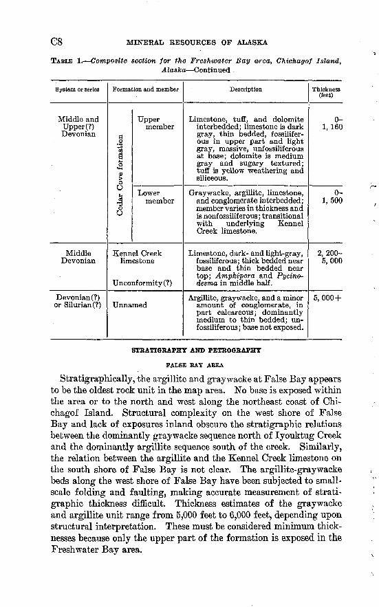
TABLE 1. Composite section for the Freshwater Bay area, Chichagof Island,Alaska Continued
System or series
Middle and Upper (?) Devonian
Middle Devonian
Devonian (?) or Silurian (?)
Formation and member
Cedar Cove formation
Upper member
Lower member
Kennel Creek limestone
Unconformity (?)
Unnamed
Description
Limestone, tuff, and dolomite interbedded; limestone is dark gray, thin bedded, fossilifer- ous in upper part and light gray, massive, unfossiliferous at base; dolomite is medium gray and sugary textured; tuff is yellow weathering and siliceous.
Graywacke, argillite, limestone, and conglomerate interbedded; member varies in thickness and is nonfossiliferous; transitional with underlying Kennel Creek limestone.
Limestone, dark- and light-gray, fossiliferous; thick bedded near base and thin bedded near top; Amphipora and Pycino- desma in middle half.
Argillite, graywacke, and a minor amount of conglomerate, in part calcareous ; dominantly medium to thin bedded; un fossiliferous; base not exposed.
Thickness (feet)
0- 1, 160
0- 1,500
2,200- 5,000
5, 000+
STRATIGRAPHY AND PETROGRAPHY
FALSE BAY ABEA
Stratigraphically, the argillite and graywacke at False Bay appears to be the oldest rock unit in the map area. No base is exposed within the area or to the north and west along the northeast coast of Chi chagof Island. Structural complexity on the west shore of False Bay and lack of exposures inland obscure the stratigraphic relations between the dominantly graywacke sequence north of lyouktug Creek and the dominantly argillite sequence south of the creek. Similarly, the relation between the argillite and the Kennel Creek limestone on the south shore of False Bay is not clear. The argillite-graywacke beds along the west shore of False Bay have been subjected to small- scale folding and faulting, making accurate measurement of strati- graphic thickness difficult. Thickness estimates of the graywacke and argillite unit range from 5,000 feet to 6,000 feet, depending upon structural interpretation. These must be considered minimum thick nesses because only the upper part of the formation is exposed in the Freshwater Bay area.

GEOLOGY OF THE FRESHWATER BAY AREA C9
The dominantly graywacke sequence at False Bay consists of more than 3,500 feet of alternate beds of dark-greenish-gray and medium- light-gray thin-bedded chloritic to calcareous fine- to medium-grained arkosic graywacke and grayish-black well-indurated slightly cal careous argillite or slate. Beds range from 0.1 to 1 foot in thickness; the graywacke beds are usually 2 or 3 times as thick as the argillite beds. Slate is common but is generally confined to local areas of intense folding; most of the fine-grained well-indurated argillaceous rock lacks cleavage or any other regular structure and is called here argillite.
The graywacke displays graded bedding, convolute bedding, small- scale crossbedding, flute casts, and drag marks. Each graywacke bed grades upward from coarser to finer grain size and, imperceptibly, into the argillite bed above. Small-scale crossbedding sets range from 0.5 to 1 inch thick. Convolute bedding, as defined by Kuenen (1953, p. 1056-1058), is apparently confined to the upper finer grained part of each graywacke bed. Bed sole markings, similar to those called flute casts and drag marks by Kuenen (1957, p. 235-246), were ob served in several places.
Alternate medium-light-gray calcareous and dark-greenish-gray chloritic layers are characteristic of the graywacke. Although these layers are roughly parallel to the bedding, several sets of alternate light-colored and dark layers may occur within a single graded cycle. The light-colored layers are generally predominant.
The graywacke is fine grained, for the most part, and the grain size ranges from 0.0625 to 0.4 mm. The median falls in the range 0.0625 to 0.125 mm (very fine sand size). Sorting is poor; coarser grains are suspended in a finer matrix and rarely touch one another.
Component percentages in the dark chloritic layers, based on visual estimates in thin section, are: quartz, 50 percent; plagioclase (An5 and An15_3 5 ), 20 percent; biotite, 1 percent; and matrix (chlorite, iron ore minerals, clay minerals) 29 percent. The grains in the dark layers range from angular to subangular.
Similar estimates in the light-colored calcareous layers are: quartz, 35 percent; plagioclase (An5 ), 6 percent; biotite, 2 percent; rock frag ments (chloritic volcanic rock, quartzite, argillite, diorite), 2 percent; and matrix (calcite and minor chlorite, quartz, clay minerals), 55 percent. The grains of quartz and plagioclase are strongly corroded and embayed by the calcite of the matrix.
The greater amount of matrix in the calcareous layers, as compared to the chloritic layers, may be due largely to the solution of quartz and feldspar grains concomitant with the precipitation of calcite. According to Correns (1950, p. 51), the precipitation of calcite in
.CIO MINERAL RESOURCES OF ALASKA
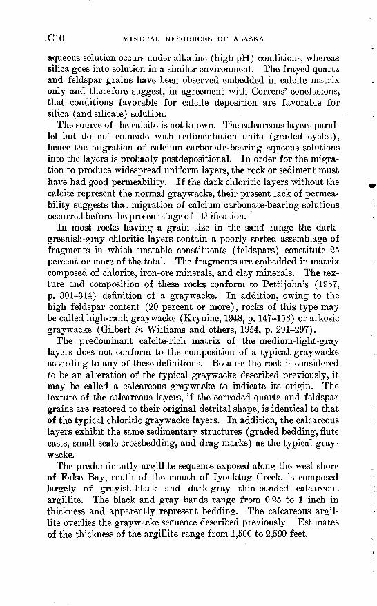
aqueous solution occurs under alkaline (high pH) conditions, whereas silica goes into solution in a similar environment. The frayed quartz and feldspar grains have been observed embedded in calcite matrix only and therefore suggest, in agreement with Correns' conclusions, that conditions favorable for calcite deposition are favorable for silica (and silicate) solution.
The source of the calcite is not known. The calcareous layers paral lel but do not coincide with sedimentation units (graded cycles), hence the migration of calcium carbonate-bearing aqueous solutions into the layers is probably postdepositional. In order for the migra tion to produce widespread uniform layers, the rock or sediment must have had good permeability. If the dark chloritic layers without the calcite represent the normal graywacke, their present lack of permea bility suggests that migration of calcium carbonate-bearing solutions occurred before the present stage of lithification.
In most rocks having a grain size in the sand range the dark- greenish-gray chloritic layers contain a poorly sorted assemblage of fragments in which unstable constituents (feldspars) constitute 25 percent or more of the total. The fragments are embedded in matrix composed of chlorite, iron-ore minerals, and clay minerals. The tex ture and composition of these rocks conform to Petti John's (1957, p. 301-314) definition of a graywacke. In addition, owing to the high feldspar content (20 percent or more), rocks of this type may be called high-rank graywacke (Krynine, 1948, p. 147-153) or arkosic graywacke (Gilbert in Williams and others, 1954, p. 291-297).
The predominant calcite-rich matrix of the medium-light-gray layers does not conform to the composition of a typical graywacke according to any of these definitions. Because the rock is considered to be an alteration of the typical graywacke described previously, it may be called a calcareous graywacke to indicate its origin. The texture of the calcareous layers, if the corroded quartz and feldspar grains are restored to their original detrital shape, is identical to that of the typical chloritic graywacke layers. In addition, the calcareous layers exhibit the same sedimentary structures (graded bedding, flute casts, small scale crossbedding, and drag marks) as the typical gray wacke.
The predominantly argillite sequence exposed along the west shore of False Bay, south of the mouth of lyouktug Creek, is composed largely of grayish-black and dark-gray thin-banded calcareous argillite. The black and gray bands range from 0.25 to 1 inch in thickness and apparently represent bedding. The calcareous argil lite overlies the graywacke sequence described previously. Estimates of the thickness of the argillite range from 1,500 to 2,500 feet.
GEOLOGY OF THE FRESHWATER BAY AREA Cll
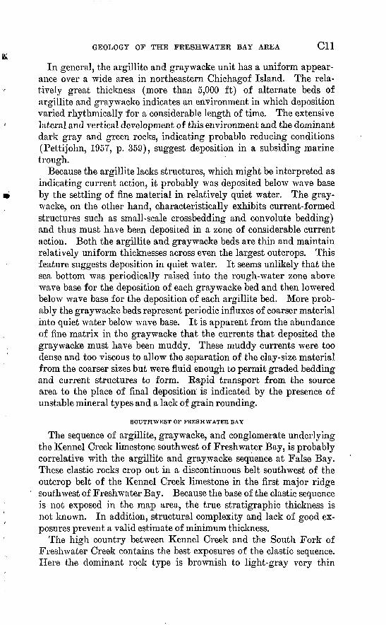
In general, the argillite and graywacke unit has a uniform appear ance over a wide area in northeastern Chichagof Island. The rela tively great thickness (more than 5,000 ft) of alternate beds of argillite and gray wacke indicates an environment in which deposition varied rhythmically for a considerable length of time. The extensive lateral and vertical development of this environment and the dominant dark gray and green rocks, indicating probable reducing conditions (PettiJohn, 1957, p. 359), suggest deposition in a subsiding marine trough.
Because the argillite lacks structures, which might be interpreted as indicating current action, it probably was deposited below wave base by the settling of fine material in relatively quiet water. The gray- wacke, on the other hand, characteristically exhibits current-formed structures such as small-scale crossbedding and convolute bedding) and thus must have been deposited in a zone of considerable current action. Both the argillite and gray wacke beds are thin and maintain relatively uniform thicknesses across even the largest outcrops. This feature suggests deposition in quiet water. It seems unlikely that the sea bottom was periodically raised into the rough-water zone above wave base for the deposition of each gray wacke bed and then lowered below wave base for the deposition of each argillite bed. More prob ably the gray wacke beds represent periodic influxes of coarser material into quiet water below wave base. It is apparent from the abundance of fine matrix in the graywacke that the currents that deposited the graywacke must have been muddy. These muddy currents were too dense and too viscous to allow the separation of the clay-size material from the coarser sizes but were fluid enough to permit graded bedding and current structures to form. Rapid transport from the source area to the place of final deposition is indicated by the presence of unstable mineral types and a lack of grain rounding.
SOUTHWEST OF FRESHWATER BAY
The sequence of argillite, graywacke, and conglomerate underlying the Kennel Creek limestone southwest of Freshwater Bay, is probably correlative with the argillite and graywacke sequence at False Bay. These clastic rocks crop out in a discontinuous belt southwest of the outcrop belt of the Kennel Creek limestone in the first major ridge
' southwest of Freshwater Bay. Because the base of the clastic sequence is not exposed in the map area, the true stratigraphic thickness is not known. In addition, structural complexity and lack of good ex posures prevent a valid estimate of minimum thickness.
The high country between Kennel Creek and the South Fork of Freshwater Creek contains the best exposures of the clastic sequence. Here the dominant rock type is brownish to light-gray very thin
C12 MINERAL RESOURCES OF ALASKA
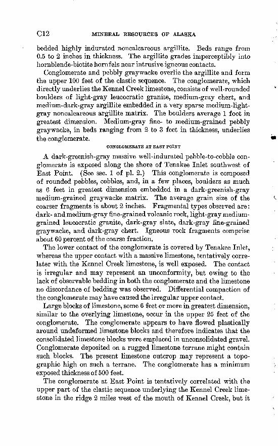
bedded highly indurated noncalcareous argillite. Beds range from 0.5 to 2 inches in thickness. The argillite grades imperceptibly into hornblende-biotite hornf els near intrusive igneous contacts.
Conglomerate and pebbly graywacke overlie the argillite and form the upper 100 feet of the clastic sequence. The conglomerate, which directly underlies the Kennel Creek limestone, consists of well-rounded boulders of light-gray leucocratic granite, medium-gray chert, and medium-dark-gray argillite embedded in a very sparse medium-light- gray noncalcareous argillite matrix. The boulders average 1 foot in greatest dimension. Medium-gray fine- to medium-grained pebbly graywacke, in beds ranging from 2 to 3 feet in thickness, underlies the conglomerate.
CONGLOMERATE AT EAST POINT
A dark-greenish-gray massive well-indurated pebble-to-cobble con glomerate is exposed along the shore of Tenakee Inlet southwest of East Point. (See sec. 1 of pi. 2.) This conglomerate is composed of rounded pebbles, cobbles, and, in a few places, boulders as much as 6 feet in greatest dimension embedded in a dark-greenish-gray medium-grained graywacke matrix. The average grain size of the coarser fragments is about 2 inches. Fragmental types observed are: dark- and medium-gray fine-grained volcanic rock, light-gray medium- grained leucocratic granite, dark-gray slate, dark-gray fine-grained graywacke, and dark-gray chert. Igneous rock fragments comprise about 60 percent of the coarse fraction.
The lower contact of the conglomerate is covered by Tenakee Inlet, whereas the upper contact with a massive limestone, tentatively corre lator with the Kennel Creek limestone, is well exposed. The contact is irregular and may represent an unconformity, but owing to the lack of observable bedding in both the conglomerate and the limestone no discordance of bedding was observed. Differential compaction of the conglomerate may have caused the irregular upper contact.
Large blocks of limestone, some 6 feet or more in greatest dimension, similar to the overlying limestone, occur in the upper 25 feet of the conglomerate. The conglomerate appears to have flowed plastically around undef ormed limestone blocks and therefore indicates that the consolidated limestone blocks were emplaced in unconsolidated gravel. Conglomerate deposited on a rugged limestone terrane might contain such blocks. The present limestone outcrop may represent a topo graphic high on such a terrane. The conglomerate has a minimum exposed thickness of 500 feet.
The conglomerate at East Point is tentatively correlated with the upper part of the clastic sequence underlying the Kennel Creek lime stone in the ridge 2 miles west of the mouth of Kennel Creek, but it
GEOLOGY OF THE FRESHWATER BAY AREA C13
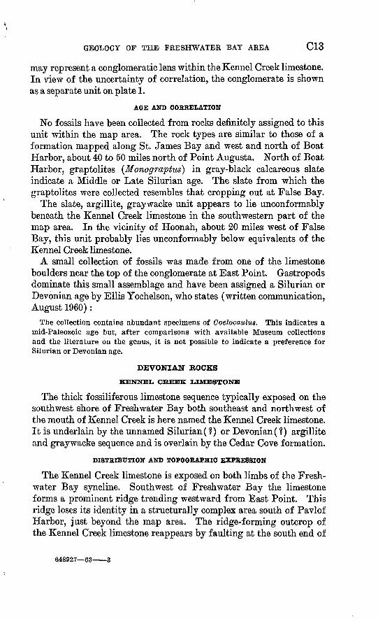
may represent a conglomeratic lens within the Kennel Creek limestone. In view of the uncertainty of correlation, the conglomerate is shown as a separate unit on plate 1.
AGE AND CORRELATION
No fossils have been collected from rocks definitely assigned to this unit within the map area. The rock types are similar to those of a formation mapped along St. James Bay and west and north of Boat Harbor, about 40 to 50 miles north of Point Augusta. North of Boat Harbor, graptolites (Monograptus) in gray-black calcareous slate indicate a Middle or Late Silurian age. The slate from which the graptolites were collected resembles that cropping out at False Bay.
The slate, argillite, graywacke unit appears to lie unconformably beneath the Kennel Creek limestone in the southwestern part of the map area. In the vicinity of Hoonah, about 20 miles west of False Bay, this unit probably lies unconformably below equivalents of the Kennel Creek limestone.
A small collection of fossils was made from one of the limestone boulders near the top of the conglomerate at East Point. Gastropods dominate this small assemblage and have been assigned a Silurian or Devonian age by Ellis Yochelson, who states (written communication, August 1960):
The collection contains abundant specimens of Coelocaulus. This indicates a mid-Paleozoic age but, after comparisons with available Museum collections and the literature on the genus, it is not possible to indicate a preference for Silurian or Devonian age.
DEVONIAN BOCKS
KENNEL CREEK LIMESTONE
The thick fossiliferous limestone sequence typically exposed on the southwest shore of Freshwater Bay both southeast and northwest of the mouth of Kennel Creek is here named the Kennel Creek limestone. It is underlain by the unnamed Silurian (?) or Devonian (?) argillite and graywacke sequence and is overlain by the Cedar Cove formation.
DISTRIBUTION AND TOPOGRAPHIC EXPRESSION
The Kennel Creek limestone is exposed on both limbs of the Fresh water Bay syncline. Southwest of Freshwater Bay the limestone forms a prominent ridge trending westward from East Point. This ridge loses its identity in a structurally complex area south of Pavlof Harbor, just beyond the map area. The ridge-forming outcrop of the Kennel Creek limestone reappears by faulting at the south end of
648927 63 3

C14 MINERAL RESOURCES OF ALASKA
Cedar Cove and extends northwest as a prominent ridge ranging from 1,500 to 3,325 feet in altitude.
North of Freshwater Bay, the Kennel Creek limestone also forms prominent ridges. Sonyakay Kidge, ranging in altitude from 1,500 to 3,000 feet and extending from Chatham Strait northwestward for about 6 miles, consists largely of Kennel Creek limestone. To the northwest the limestone is exposed as a series of prominent peaks on transverse northeastward-trending ridges.
STRATIGRAPHY
Although the Kennel Creek limestone overlies the Silurian(?) or Devonian (?) argillite and graywacke sequence, the nature of the con tact is not known. At the type section near Kennel Creek, the lime stone section is terminated at the base by a fault. Complex structure and poor exposures prevented determination of the nature of the lower contact in other areas. The irregular contact between the mas sive limestone and underlying conglomerate at East Point suggests a disconformity. Because of sparseness of fossils and lack of good exposures in the East Point area, the correlation of the massive lime stone with the Kennel Creek limestone and the underlying conglom erate with the Silurian (?) or Devonian (?) clastic sequence is only a tentative one.
The Kennel Creek limestone grades upward into the Cedar Cove for mation. The top of the Kennel Creek limestone is arbitrarily drawn at the base of the lowest interbedded limestone and graywacke unit of the Cedar Cove formation. Below this contact, the upper part of the Kennel Creek limestone consists of thin-bedded limestone with very thin siliceous very fine grained tuffaceous partings.
The Kennel Creek limestone ranges from more than 2,200 to 5,000 feet in thickness and averages about 3,500 feet thick. Because the limestone is very massive in some localities, an accurate determina tion of the structural attitude and effect of faulting could not be made; hence, thickness measurements were not obtained.
Medium- to light-gray medium-grained thick-bedded to massive limestone is a prominent rock type in the lower part of Kennel Creek limestone west and north of the type locality, but is not present at the type locality. The more massive lower part forms large structureless bosslike masses on the ridge crests and peaks. The limestone is nearly homogeneous and grades into white medium- to coarse-crystalline mar ble near igneous intrusions and in places along the zone of the South Shore fault. The absence of the lower massive sequence at the type locality is probably due to the major fault that cuts off the lower part of the type section. A high cliff composed of white sheared limestone,
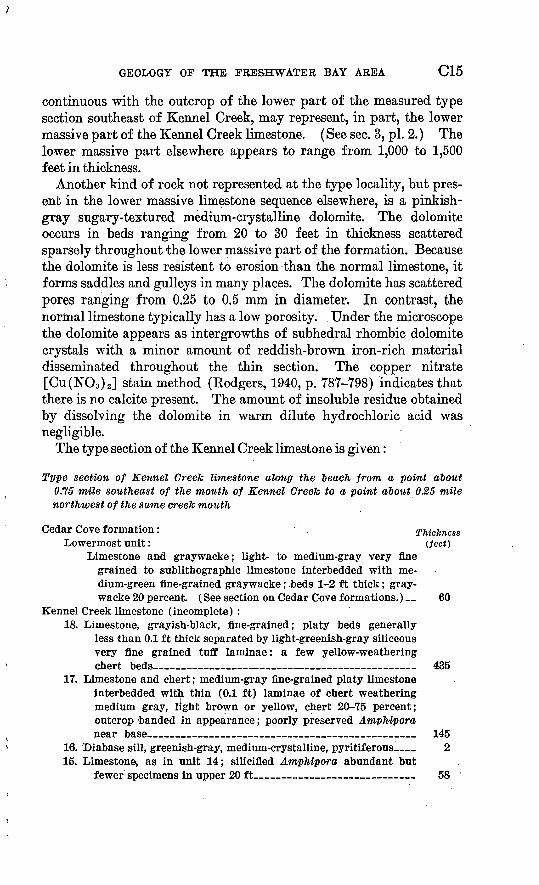
GEOLOGY OF THE FRESHWATER BAY AREA C15
continuous with the outcrop of the lower part of the measured type section southeast of Kennel Creek, may represent, in part, the lower massive part of the Kennel Creek limestone. (See sec. 3, pi. 2.) The lower massive part elsewhere appears to range from 1,000 to 1,500 feet in thickness.
Another kind of rock not represented at the type locality, but pres ent in the lower massive limestone sequence elsewhere, is a pinkish- gray sugary-textured medium-crystalline dolomite. The dolomite occurs in beds ranging from 20 to 30 feet in thickness scattered sparsely throughout the lower massive part of the formation. Because the dolomite is less resistent to erosion than the normal limestone, it forms saddles and gulleys in many places. The dolomite has scattered pores ranging from 0.25 to 0.5 mm in diameter. In contrast, the normal limestone typically has a low porosity. Under the microscope the dolomite appears as intergrowths of subhedral rhombic dolomite crystals with a minor amount of reddish-brown iron-rich material disseminated throughout the thin section. The copper nitrate [Cu(NO3 ) 2 ] stain method (Kodgers, 1940, p. 787-798) indicates that there is no calcite present. The amount of insoluble residue obtained by dissolving the dolomite in warm dilute hydrochloric acid was negligible.
The type section of the Kennel Creek limestone is given:
Type section of Kennel Creek limestone along the leach from a point about 0.75 mile southeast of the mouth of Kennel Creek to a point about 0.25 mile northwest of the same creeJc mouth
Cedar Cove formation: . Thickness Lowermost unit: (feet)
Limestone and graywacke; light- to medium-gray very fine grained to sublithographic limestone interbedded with me dium-green fine-grained graywacke; beds 1-2 ft thick; gray wacke 20 percent. (See section on Cedar Cove formations.) 60
Kennel Creek limestone (incomplete) :18. Limestone, grayish-black, fine-grained; platy beds generally
less than 0.1 ft thick separated by light-greenish-gray siliceous very fine grained tuff laminae: a few yellow-weathering chert beds________________ __ _ ___ _ 435
17. Limestone and chert; medium-gray fine-grained platy limestone interbedded with thin (0.1 ft) laminae of chert weathering medium gray, light brown or yellow, chert 20-75 percent; outcrop banded in appearance; poorly preserved Amphipora near base______________________________ 145
16. Diabase sill, greenish-gray, medium-crystalline, pyritiferous__ 2 15. Limestone, as in unit 14; silicified Amphipora abundant but
fewer specimens in upper 20 ft 58
C16 MINERAL RESOURCES OF ALASKA
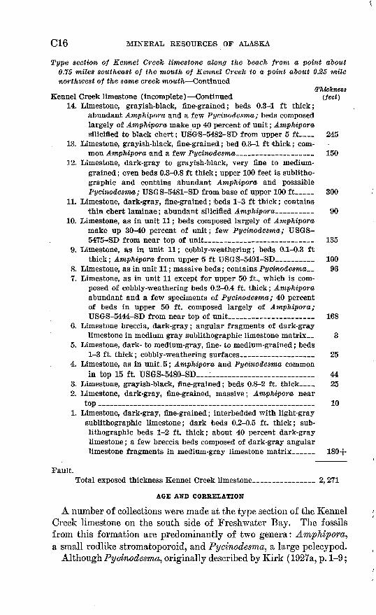
Type section of Kennel Creek limestone along the beach from a point about 0.75 miles southeast of the mouth of Kennel Creek to a point about 0.25 mile northwest of the same creek mouth Continued
(ThicknessKennel Creek limestone (incomplete) Continued (feet)
14. Limestone, grayish-black, fine-grained; beds 0.3-1 ft thick; abundant Amphipora and a few Pycinodesma; beds composed largely of Amphipora make up 40 percent of unit; Amphipora silicified to black chert; USGS-5482-SD from upper 5 ft__ 245
13. Limestone, grayish-black, fine-grained; bed 0.3-1 ft thick; com mon Amphipora and a few Pycinodesma____ ___ 150
12. Limestone, dark-gray to grayish-black, very fine to medium- grained ; even beds 0.3-0.8 ft thick; upper 100 feet is sublitho- graphic and contains abundant Amphipora and posssible Pycinodesma; USGS-5481-SD from base of upper 100 ft___ 300
11. Limestone, dark-gray, fine-grained; 'beds 1-3 ft thick; containsthin chert laminae; abundant silicified Amphipora____ _ 90
10. Limestone, as in unit 11; beds composed largely of Amphipora make up 30-40 percent of unit; few Pycinodesma; USGS- '5475-SD from near top of unit_______ 135
9. Limestone, as in unit 11; cobbly-weathering; beds 0.1-0.3 ftthick; Amphipora from upper 5 ft USGS-5491-SD______ 100
8. Limestone, as in unit 11; massive beds; contains Pycinodesma_ 96 7. Limestone, as in unit 11 except for upper 50 ft., which is com
posed of cobbly-weathering beds 0.2-0.4 ft. thick; Amphipora abundant and a few speciments of Pycinodesma; 40 percent of beds in upper 50 ft. composed largely of Amphipora; USGS-5444-SD from near top of unit_______________ 168
6. Limestone breccia, dark-gray; angular fragments of dark-graylimestone in medium gray sublithographic limestone matrix 3
5. Limestone, dark- to medium-gray, fine- to medium-grained; beds1-3 ft. thick; cobbly-weathering surfaces_ ___ _ 25
4. Limestone, as in unit. 5; Amphipora and Pycinodesma commonin top 15 ft. USGS-5480-SD__________________ 44
3. Limestone, grayish-black, fine-grained; beds 0.8-2 ft. thick__ 25 2. Limestone, dark-gray, fine-grained, massive; Amphipora near
top ____________________________________ 10 1. Limestone, dark-gray, fine-grained; interbedded with light-gray
sublithographic limestone; dark beds 0.2-0.5 ft. thick; sub- lithographic beds 1-2 ft. thick; about 40 percent dark-gray limestone; a few breccia beds composed of dark-gray angular limestone fragments in medium-gray limestone matrix____ 180+
Fault.Total exposed thickness Kennel Creek limestone__________ 2,271
AGE AND COBBELATION
A number of collections were made at the type section of the Kennel Creek limestone on the south side of Freshwater Bay. The fossils from this formation are predominantly of two genera: AmpMpora, a small rodlike stromatoporoid, and Pycinodesma, a large pelecypod.
Although Pycinodesma, originally described by Kirk (1927a, p. 1-9;
GEOLOGY OF THE FRESHWATER BAY AREA C17
1927b, p. 543), was considered to be of Late Silurian age, it now seems probable that the stratigraphic significance of this genus was misinterpreted.
The only recorded locality outside Alaska where similar pelecypods have been collected is in the Gold Hill district, Utah. Kirk (in Nolan, 1935, p. 21) reported this occurrence from beds above the Strmgo- cephalus zone, which suggests a late Middle or early Late Devonian age.
Ampkipom is extremely common in rocks of Middle and early Late Devonian age throughout the Western United States, Canada, and in other parts of Alaska. This stromatoporoid genus has been reported from the Silurian of Russia, but the faunal evidence supporting this age assignment is either absent or inconclusive.
The stratigraphic evidence that led Kirk to give a Silurian age assignment to the beds at Freshwater Bay has been reevaluated.' There now seems to be no compelling argument in favor of a Late Silurian age for these beds, based on physical stratigraphy alone.
The most telling argument for a Middle Devonian age assignment is the occurrence, in beds correlated with the Kennel Creek, of a f avo- sitid-rugose coral assemblage that is of probable Middle Devonian age. For this reason the age of the Kennel Creek limestone is here con sidered to be Middle Devonian.
CEDAR COVE FORMATION
The sequence of clastic and carbonate rocks overlying the Kennel Creek limestone and underlying the Freshwater Bay formation is here named the Cedar Cove formation. The name is taken from Cedar Cove on the southwest shore of Freshwater Bay, near which the for mation is typically exposed. The type section extends from a point on the west shore of Cedar Cove, about due west of the north tip of Cedar Island, northwestward along the shore for a distance of about 3 miles.
DISTRIBUTION AND TOPOGRAPHIC EXPRESSION
The Cedar Cove formation appears to have a restricted distribution in the Freshwater Bay area. The outcrops at Cedar Cove and those northwest of Kennel Creek constitute the best exposures of the forma tion. Graywacke overlying the massive Kennel Creek limestone at East Point near the mouth of Freshwater Bay is tentatively cor related with the Cedar Cove formation. Whether or not the Cedar Cove formation exists anywhere west of the Kennel Creek fault has not 'been determined. The formation has not been recognized in the area drained by Freshwater Creek west of the head of Freshwater Bay. Exposures are poor in these areas, however, and it is not certain that the Cedar Cove formation is actually missing.
CIS MINERAL RESOURCES OF ALASKA
Near the north border of the map, near the head of lyouktug Creek, an estimated 1,250 feet of thin interbeds of argillite, graywacke, and limestone that overlie the Kennel Creek limestone and underlie vol canic rocks of the Freshwater Bay formation are correlated with the Cedar Cove formation. However, poor exposures in this area prevent the obtaining of accurate straigraphic data. Southeast of this local ity, along strike, the Cedar Cove formation is missing and the Ken nel Creek limestone is in contact with volcanic rocks of the Fresh water Bay formation; exposures on the northwest end of Sonyakay Ridge show this relation clearly. The Cedar Cove formation appar ently does not reappear to the southeast between the northwest end of Sonyakay Ridge and lyoukeen Cove.
Areas underlain by rocks of the Cedar Cove formation in most places consist of lowlands with a few narrow ridges. The conglomer ate and the more massive limestone form the ridges.
STRATIGEAPHY AND PETROGRAPHY
The contact between the Cedar Cove formation and the underlying Kennel Creek limestone appears to be transitional and is arbitrarily drawn at the base of the lowest interbedded graywacke and lime stone unit. Below this level the Kennel Creek limestone contains only minor thin beds of fine-grained clastic rocks.
The upper contact of the Cedar Cove formation is not exposed in the Freshwater Bay area; however, this contact is probably an un conformity because the Cedar Cove formation is missing in parts of the area. Where the formation is thinner than normal, thinning appears to be due to the removal of strata from the upper part of the formation. For example, west of Kennel Creek only the lower and nonfossiliferous limestone unit of the upper member remains. West of East Point only the predominantly clastic lower member is present Near the north border of the area, in the headwaters of lyouktug Creek, the upper member is apparently missing.
The unconformity at the top of the Cedar Cove is further docu mented by section 4, 5, and 6 shown on plate 2. In these sections, sedimentary rocks occur in the Freshwater Bay formation about 2,500 to 3,000 feet stratigraphically below the top. The sedimentary rock units maintain this level in the three sections, whereas the base of the Freshwater Bay formation appears to rise where the Cedar Cove formation is thick and to fall where the Cedar Cove is thin or nonexistent. This relation suggests deposition of the chiefly volcanic rocks of the Freshwater Bay formation upon an irregular topography cut in the rocks of the Cedar Cove formation.
The Cedar Cove formation, at its type section, may be divided into two members: a lower dominantly thin-bedded argillite member
GEOLOGY OF THE FRESHWATER BAY AREA C19
and an upper dominantly limestone member. In addition to argillite, the lower member contains thin beds of limestone near the base. The upper member contains a prominent massive unf ossilif erous limestone at the base. Overlying the massive limestone is a sequence of thin- bedded fossiliferous limestone containing a minor number of thin yellow-weathering siliceous tuff beds. The formation has a maximum exposed thickness of about 2,660 feet at the type section. West of Kennel Creek the lower member contains abundant graywacke and lesser amounts of conglomerate; at this locality the upper fossil iferous part of the upper member is missing. (See measured section p. C21.)
Dark-greenish-gray well-indurated medium- to coarse-grained arkosic lithic graywacke is an important rock type in the lower member northwest of the mouth of Kennel Creek. In hand specimen, the gray wacke contains pink coarse (1-3 mm in diameter) rounded grains scattered throughout and very thin black layers, parallel to bedding, that have a sharply defined base but grade upward into the normal green graywacke. These black layers are composed of rounded pyrite grains and each may represent the beginning of a cycle of graded sedimentation within a single homogeneous-appearing graywacke bed. Aside from the black layers, any given graywacke bed shows few indications of graded bedding, except near the top where grain-size decreases rapidly and medium-grained graywacke grades into an over lying argillite bed within a space of 5 to 10 mm.
In thin section the graywacke appears to be composed of rounded to subrounded grains of plagioclase, potassic feldspar, quartz, and pyrite, with volcanic rock fragments embedded in an abundant matrix com posed of chlorite, epidote, secondary albite, secondary quartz, and iron-ore'minerals. The pink grains observed in hand specimen ap pear to be mostly potassic feldspar, but some may be chert. The types of volcanic rock fragments are: porphyritic, composed of plagioclase phenocrysts in a very fine grained chloritic matrix; silicified, composed of fine and very fine grained mosaics of quartz with minor plagioclase crystals; and partly silicified, with fine trachytic texture, composed of plagioclase microlites, chlorite^ and quartz. Detrital grains range from 0.25 to 3 mm. Visual estimates of the component percentages are: plagioclase (An10.i 5 and An32 ), 30 percent; potassic feldspar, 2 percent; quartz, 5 percent; pyrite, 3 percent; volcanic rock fragments, 30 percent; and matrix, 30 percent.
The predominance of unstable components (feldspars and rock frag ments constituting more than 60 percent of the rock) embedded in an abundant chloritic matrix agrees with Petti John's (1957, p. 301-314) definition of a graywacke. The high percentage of feldspar (greater
C20 MINERAL RESOURCES OF ALASKA
than 30 percent) places this rock among Krynine's (1948, p. 147-153) high-rank graywacke. The high feldspar content and the high per centage of unstable rock fragments (30 percent) classifies this rock as either volcanic graywacke or as arkosic lithic graywacke according to Gilbert (in Williams and others 1954, p. 291-294).
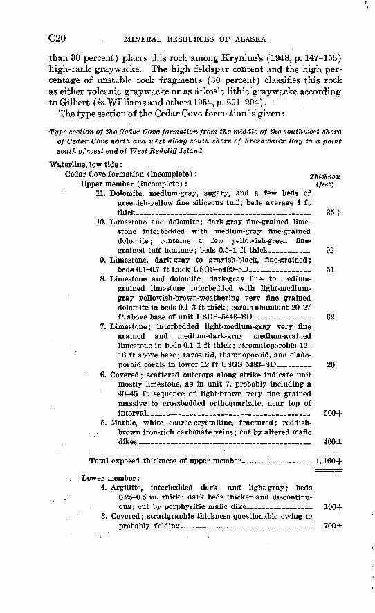
The type section of the Cedar Cove formation is given:
Type section of the Cedar Cove formation from the middle of the southivest shore of Cedar Cove north and west along south shore of Freshwater Bay to a point south of west end of West Redcliff Island
Waterline, low tide:Cedar Cove formation (incomplete): Thickness
Upper member (incomplete): (feet) 11. Dolomite, medium-gray, 'sugary, and a few beds of
greenish-yellow fine siliceous tuff; beds average 1 ft thick_____ _ _ _____ ___ 35+
10. Limestone and dolomite; dark-gray fine-grained lime stone interbedded with medium-gray fine-grained dolomite; contains a few yellowish-green fine grained tuff laminae; beds 0.5-1 ft thick-______ 92
9. Limestone, dark-gray to grayish-black, fine-grained;beds 0.1-0.7 ft thick USGS-5489-5D__________ 51
8. Limestone and dolomite; dark-gray fine- to medium- grained limestone interbedded with light-medium- gray yellowish-brown-weathering very fine grained dolomite in beds 0.1-3 ft thick; corals abundant 20-27 ft above base of unit USGS-5446-SD_________ 62
7. Limestone; interbedded light-medium-gray very fine grained and medium-dark-gray medium-grained limestone in beds 0.1-1 ft thick; stromatoporoids 12- 16 ft above base; favositid, thamnoporoid, and clado- poroid corals in lower 12 ft USGS 5483-SD_____ 20
6». Covered; scattered outcrops along strike indicate unit mostly limestone, as in unit 7, probably including a 40-45 ft sequence of light-brown very fine grained massive to crossbedded orthoquartzite, near top of interval___ _ _ ____________ __ 500+
5. Marble, white coarse-crystalline, fractured; reddish- brown iron-rich carbonate veins; cut by altered mafic dikes ___________________________ 400±
Total exposed thickness of upper member _ _ 1,160+
Lower member:4. Argillite, interbedded dark- and light-gray; beds
0.25-0.5 in. thick; dark beds thicker and discontinu ous; cut by porphyritic mafic dike___________ 100+
3. Covered; stratigraphic thickness questionable owing toprobably folding._ ________________ 700±
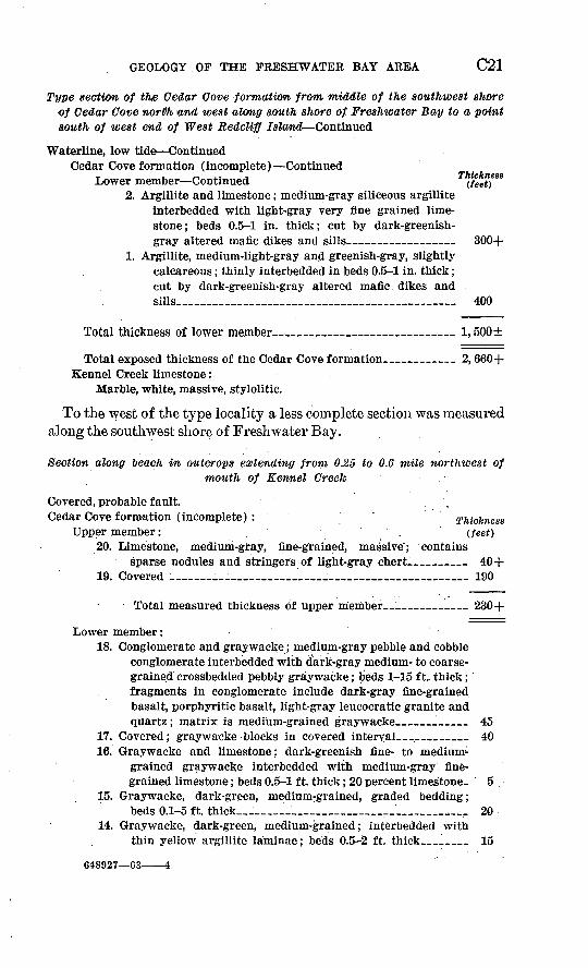
GEOLOGY OF THE FRESHWATER BAY AREA C21
Type section of the Cedar Cove formation from middle of the southwest shore of Cedar Cove north wnd west along south shore of. Freshwater Bay to a point south of west end of West Redcliff Island Continued
Waterline, low tide ContinuedCedar Cove formation (incomplete) Continued
Lower member Continued2. Argillite and limestone; medium-gray siliceous argillite
interbedded with light-gray very fine grained lime stone; beds 0.5-1 in. thick; cut by dark-greenish- gray altered mafic dikes and sills 300+
1. Argillite, medium-light-gray and greenish-gray, slightly calcareous; thinly interbedded in beds 0.5-1 in. thick; cut by dark-greenish-gray altered mafic dikes and sills___________________________ 400
Total thickness of lower member __________*___ 1,500±
Total exposed thickness of the Cedar Cove formation_______ 2, 660+ Kennel Creek limestone:
Marble, white, massive, stylolitic.
To the west of the type locality a less complete section was measured along the southwest shore of Freshwater Bay.
Section along oeach in outcrops extending froni 03,5 to 0.6 mile northwest ofmouth of Kennel Creek .
Covered, probable fault. , Cedar Cove formation (incomplete) : ' Thickness
Upper member: . (feet) 20. Limestone, medium-gray, fine-grained, massive"; contains
sparse nodules and stringers of light-gray chert-______ 40+ 19. Covered __________:_:__________________ 190
Total measured thickness of upper member 230+
Lower member:18. Conglomerate and graywacke; medium-gray pebble and cobble
conglomerate interbedded with dark-gray medium- to coarse grained crossbedcled pebbly graywacke; beds 1-15 ft., thick; fragments in conglomerate include dark-gray fine-grained basalt, porphyritic basalt, light-gray leucocratic granite and quartz; matrix is medium-grained graywacke _____ 45
17. Covered; graywacke blocks in covered interval______ 4016. Graywacke and limestone; dark-greenish fine- to medium-
grained graywacke interbedded with medium-gray, fine grained limestone; beds 0.5-1 ft. thick; 20 percent limestone- 5
15. Graywacke, dark-green, medium-grained, graded bedding;beds 0.1-5 ft. thick ___!____________________ 20
14. Graywacke, dark-green, medium-grained; interbedded withthin yellow argillite laminae; beds 0.5-2 ft. thick __ 15
648927 63 4
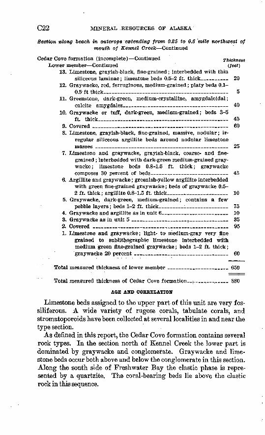
C22 MINERAL -RESOURCES OF ALASKA
Section blong "beach in outcrops extending from 0.25 to 0.6 mile northwest of mouth of Kennel Greek Continued
Cedar Cove formation (incomplete) Continued Thickness Lower member Continued (feet)
13. Limestone, grayish-black, fine-grained; interbedded with thinsiliceous laminae; limestone beds 0.5-2 ft. thick 20
12. Graywacke, red, ferruginous, medium-grained; platy beds 0.1-0.5 ft thick_____________________________ 5
11. Greenstone, dark-green, medium-crystalline, amygdaloidal;calcite amygdales 40
10. Graywacke or tuff, dark-green, medium-grained; beds 3-5ft. thick________ ___ 45
9. Covered ___________________ ___ _ 60 8. Limestone, grayish-black, fine-grained, massive, nodular; ir
regular siliceous argillite beds around nodular limestone masses _ 25
7. Limestone and graywacke, grayish-black, coarse- and fine grained ; interbedded with dark-green medium-grained gray wacke; limestone beds 0.8-1.5 ft. thick; graywacke composes 30 percent of beds_ _ 45
6. Argillite and graywacke; greenish-yellow argillite interbedded with green fine-grained graywacke; beds of graywacke 0.5- 2 ft. thick; argillite 0.8-1.5 ft. thick________:_____ 10
5. Graywacke, dark-green, medium-grained; contains a few1 pebble layers; beds 1-2 ft. thick ______________ 75
4. Graywacke and argillite as in unit 6___ ___ _ 10 3. Graywacke as in unit 5 ___ ___ ________ 352. Covered .______ ______________________ 951. Limestone and graywacke; light- to medium-gray very fine
grained to sublithographic limestone interbedded with medium green fine-grained graywacke; beds 1-2 ft. thick; graywacke 20 percent _____ _____________ 60
Total measured thickness of lower member ______________ 650
Total measured thickness of Cedar Cove formation_;_______ 880
AGE AND CORRELATION
Limestone beds assigned to the upper part of this unit are very f os- siliferous. A wide variety of rugose corals, tabulate corals, and stromatoporoids have been collected at several localities in and near the type section.
As denned in this report, the Cedar Cove formation contains several rock types. In the section north of Kennel Creek the lower part is dominated by graywacke and conglomerate. Graywacke and lime stone beds occur both above and below the conglomerate in this section. Along the south side of Freshwater Bay the clastic phase is repre sented by a quartzite. The coral-bearing beds lie above the clastic rock in this sequence.
GEOLOGY OF THE FRESHWATER BAY AREA C23
The fossils are of types found elsewhere in the world in beds of similar facies that range in age from late Middle to early Late Devon ian. Clastic layers within the overlying Freshwater Bay formation at Port Frederick contain fossils of late Frasnian age, giving an effec tive upper limit for the age of the Cedar Cove. For purposes of this report, this formation is considered of Middle and Upper (?) Devo nian age, since it could be possibly as young as early Late Devonian (early Frasnian).
FRESHWATER BAY FORMATION
The thick sequence of volcanic and intercalated sedimentary rocks overlying the Cedar Cove formation and, in places, the Kennel Creek limestone and underlying the lyoukeen formation is here named the Freshwater Bay formation.
The type locality is near the head of Freshwater Bay; here shore line exposures contain rock types which are considered characteristic of the formation.
DISTRIBUTION AND TOPOGRAPHIC EXPRESSION
The rocks of the Freshwater Bay formation form a northwestward- treading belt of exposures averaging about 2 miles wide at Freshwater Bay, on the southwest limb of the Freshwater Bay syncline. The outcrop belt widens to more than 3 miles to the northwest near the west margin of the map area. On the northeast limb of the syncline, the outcrop belt maintains a width of about 1 mile from the head waters of Wukuklook Creek northwestward.
For the most part, the rocks of Freshwater Bay formation are non- resistant and underlie valleys and low ridges. Freshwater Bay and the broad valley continue to trend northwestward and are largely underlain by the volcanic rock of this formation.
STRATIGRAPHY AND PETROGRAPHY
Both the upper and the lower contacts of the Freshwater Bay forma tion appear to represent unconformities. The evidence for the lower unconformity is largely stratigraphic. Different beds underlie the Freshwater Bay formation in different places. The Cedar Cove formation is the underlying formation on the southwest limb of the Freshwater Bay syncline, whereas on the southwest flank of Sonyakay Mountain, on the northeastern limb of the syncline, the Cedar Cove formation is missing and the Freshwater Bay formation lies directly on the Kennel Creek limestone.
The contact of the Freshwater Bay formation and the overlying lyoukeen formation appears also to be unconformable. Bedding at titudes at the top of the Freshwater Bay formation are discordant
C24 MINERAL RESOURCES OF ALASKA
with those of the limestone near the base of the lyoukeen formation in the few places where the contact is exposed. "Removal of beds by erosion from the top of the Freshwater Bay formation is difficult to demonstrate, because of the highly variable nature of the volcanic rocks.
The Freshwater Bay formation is estimated to range in thickness from about 6,500 feet near the mouth of Freshwater Bay to about 5,000 feet near the head of the bay, but it is believed to be complicated considerably by faults. In the northeast limb of the Freshwater Bay syncline, it is about 4,500 feet thick near the head of Wukuklook Creek. The formation may thin eastward toward the mouth of the creek but does not crop out there because of truncation by faulting.
Because of abrupt variations in the rocks of the Freshwater Bay formation, their description is divided below into two parts: (1) rocks on the southwest limb of the Freshwater Bay syncline, and (2) rocks on the northeast limb of the Freshwater Bay syncline.
SOUTHWEST LIMB OF FRESHWATER BAY SYNCLINE
The Freshwater Bay formation on the southwest limb of the Fresh water Bay syncline is composed of volcanic flows, tuff, breccia, and a minor amount of water-laid volcanic sedimentary rock. Although the strata vary widely in character, for descriptive purposes they may be divided into a lower greenstone member, a middle rhyolitic mem ber, and an upper andesitic member. The members can be recognized only in the immediate vicinity of Freshwater Bay and do not apply to the northeast limb of the Freshwater Bay syncline.Lower Greenstone Member
The lower greenstone member is exposed along the southwest shore of Freshwater Bay from East Point northwestward to Wachusett Cove and in a relatively narrow belt northwest of the mouth of Kennel Creek. It ranges in thickness from about 3,000 feet near Wachusett Cove to about 1,800 feet northwest of Kennel Creek. Because of the lack of marker beds within the member, it is not possible to distinguish changes in thickness due to faulting from those due to deposition.
Although the rock of this member is generally dark gray, it weathers to a characteristic dark greenish gray, which is an indication of alter ation. The greenstone seems to represent altered mafic volcanic flows rather than pyroclastic rock, because it is rather homogeneous and dis plays no clastic texture. Moreover, rocks suggestive of pillow and columnar structures occur in this member. In most places the flows are massive and have indistinct boundaries.
Upon examination of thin sections, the original minerals appear to have been almost completely altered to sericite, albite, epidote, chlorite,
GEOLOGY OF THE FRESHWATER BAY AREA C25
calcite, and iron-ore minerals. Some of the rock is porphyritic and is composed of sericitized and albitized plagioclase phenocrysts, aver aging 5 mm long, in a fine-grained groundmass of sericitized feldspar laths, granular epidote, interstitial chlorite, fine anhedral albite, clots of calcite, and disseminated iron-ore minerals. One thin section con tains clots of chlorite suggestive of relict mafic phenocrysts embedded in a groundmass similar to that described previously. The feldspars are so finely divided by sericitization that accurate identification and differentiation from possible secondary albite is not possible.
Because the original rock types cannot be known with certainty but were probably mafic in composition, this rock is called greenstone. The term "greenstone" is used here to describe an originally mafic vol canic rock altered to a suite of secondary minerals characterized by abundant chlorite, epidote, and, in some places actinolite-hornblende.
Middle Rhyolltlc Member
The middle rhyolitic member is exposed from the north headland of Wachusett Cove to Cedar Cove, on the Redcliff Islands, and near the head of Freshwater Bay on both sides of the mouth of Freshwater Creek.
Thickness ranges from about 1,500 feet near Wachusett Cove to about 1,200 feet at the head of the bay. In contrast to the underlying greenstone member, the rhyolitic member is generally light colored, thin bedded, and highly variable. Colors are predominantly shades of red but include lesser amounts of purple, green, and gray. Most of the red-weathering rocks are also red on a fresh surface, but in a few places the fresh rock is light gray, with the red color limited to the surface.
Although most beds range in thickness from 2 inches to 2 feet, a few beds 10 feet or more in thickness were observed.
Pyroclastic rock predominates over flows and ranges from possible "welded" tuff to volcanic graywacke. In addition, a few small intru sive igneous bodies, presumably of shallow origin, are considered to be closely associated with the Freshwater Bay formation volcanism and are therefore described in this section.
Most of the pyroclastic rock is rhyolitic tuff and breccia, but the composition of fragments and matrix ranges widely. The tuff grades into volcanic graywacke and differentiation between the two rock types is difficult. Although it is beyond the scope of this work to describe the"many variations of composition and texture in the pyro clastic rock of this member, a few representative types are described as follows.
Among the many color combinations are: pale-red fragments in dark-red matrix; dark-red fragments in pale-red matrix; moderate
C26 MINERAL RESOURCES OF ALASKA
orange-pink fragments in dark-greenish-gray matrix; and dark-red fragments in dark-red matrix. Typical fragments are: fine-grained silicified rhyolite, partly recrystallized chert, quartz, albite-oligoclase, potassic feldspar, and baked argillite. The fragments range from less than 0.05 nun to more than 300 mm in diameter, but most frag ments range from 0.5 to 4 mm. The fragments also range from rounded to angular.
The typical rhyolitic tuff is dusky red, finely banded, and well indurated. It is grayish red on fresh surfaces and contains dusky red-purple subangular argillite fragments, ranging in length from 1 to 10 mm, scattered in a fine-grained thinly laminated matrix. In addition, the rock appears in thin section to consist of slightly rounded euhedral orthoclase and quartz crystals, averaging 0.4 mm long, scat tered in a fine-grained cloudy iron-rich quartzofeldspathic matrix. The matrix is composed of fine angular fragments, crystals of quartz and feldspar, and fine fragments of argillite. Although the particles of the matrix are commonly oriented subparallel to bedding, they bend around coarser fragments in a manner suggesting compaction. Visually estimated component percentages are: orthoclase grains, 20 percent; quartz grains, 10 percent; argillite grains, 5 percent; iron- ore mineral grains, 5 percent; and matrix, 60 percent.
Volcanic graywacke, much less abundant than tuff, is typically dusky yellow green, well indurated, medium bedded, and coarse grained. In thin section it appears to be composed of subrounded to subangular grains averaging 2 mm in greatest dimension; the grains, however, are poorly sorted and range from submicroscopic to 3.5 mm. Major constituents are: very fine grained volcanic rock fragments consisting of semiopaque material, feldspar microlites and chlorite, and partly sericitized plagioclase laths ranging in com position from An8 to An15 . Minor constituents are: quartzitic re- crystallized chert and chloritic, quartzitic siltstone fragments. All the grains are embedded in a very fine grained cloudy micaceous matrix composed of chlorite and interlayered illite and montmoril- lonite. The composition of the matrix was determined by Julius Schlocker of the U.S. Geological Survey by X-ray defraction methods. Visual estimates of the component percentages are: plagioclase grains, 35 percent; rock fragments, 50 percent; and matrix, 15 percent.
Because this rock contains abundant volcanic rock fragments em bedded in a well-indurated niicaceous-chloritic matrix, it is volcanic graywacke in the classification of Gilbert (in Williams, and others, 1954, p. 291-294).
Flow rock is apparently less abundant than pyroclastic rock in the rhyolitic member, but no precise statement about the relative abun-
GEOLOGY OF THE FRESHWATER BAY AREA C27
dance of the two types can be made, owing to the difficulty of dis tinguishing between them in the field. Without exception, the light- gray felsitic rock showed clastic texture upon examination of thin section. No generalization as to a possible correlation between color and texture can be made, however, because of the lack of detailed sampling.
In hand specimen, the darker hued soda-rhyolite flow rock is dark reddish gray and contains fairly abundant pale-red feldspar pheno- crysts, averaging 2 mm long, embedded in a dark-red aphanitic groundmass. In thin section the rock appears to be composed of partly resorbed euhedral phenocrysts of microperthitic potassic feld spar in a fine-grained granular groundmass of quartz, potassic felds par, sodic plagioclase, anhedral greenish-yellow and dark-greenish- blue pleochroic sodic amphibole, calcite, and iron ore minerals. The plagioclase, limited to the groundmass and perthitic intergrowths, is difficult to determine accurately. Visual estimates of component per centages are: feldspar (including potassic feldspar and plagioclase), 30 percent; quartz and plagioclase in groundmass, 25 percent; sodic amphibole, 25 percent; calcite, 5 percent; iron ore minerals, 15 percent; and sphene, trace amounts.
Several small igneous bodies intrude the rocks of the rhyolitic mem ber. Two of the largest, described as follows, are small pluglike bodies whose true outlines are unknown because both are largely surrounded by water.
The larger of these bodies, forming Cedar Island near the middle of the southwest shore of Freshwater Bay, has a minimum diameter of 1,800 feet. The massive outcrops weather to a mottled dusky yel low and grayish olive green, but the rock on fresh surface is greenish gray.
In thin section, the rock appears to be composed of euhedral pheno crysts, averaging 1 mm long, of partly sericitized albite-twinned plagioclase (An30-An38 ) and partly chloritized augite in an indistinct altered groundmass composed of plagioclase, potassic feldspar, seri- cite, epidote, chlorite, and iron-ore minerals. The ratio of plagioclase to potassic feldspar is about 1:1. This mineral association and tex ture suggests a vogesite lamprophyre (Williams and others, 1954, p. 84-92).
The smaller body of the two studied forms a narrow low rocky is land about YOO feet long and 200 feet wide near the southwest shore of Freshwater Bay, about iy2 miles southeast from the mouth of Freshwater Creek. The long dimension of the island trends north westward, about parallel to the strike of the bedded rocks. In hand specimen, the rock is massive, medium crystalline, and pale red with
C28 MINERAL RESOURCES OF ALASKA
dark-green patches on a fresh surface. It weathers pale-reddish brown.
In thin section the rock appears to have an intergranular texture composed of subhedral albite-twinned crystals of plagioclase averag ing 0.5 mm long, slightly larger anhedral plates of potassic feldspar, and clots of chlorite, calcite, and iron-ore minerals forming pseudo- morphs after euhedral amphibole crystals. The strongly cericitized plagioclase ranges in composition from An5 to Ani5 . The potassic feldspar is strongly altered to kaolin and sericite. The ratio of plagioclase to potassic feldspar is about 1: 3. In composition and tex ture this rock resembles a vogesite lamprophyre (Williams and others, 1954, p. 84-92), but the high degree of alteration precludes a definite classification.
Upper andesltic member
The upper andesitic member crops out along the northeast shore of Freshwater Bay from the cove due north of Cedar Island northwest ward to the head of the bay. The total thickness cannot be measured, because the contact with the underlying rhyolitic member is covered by the waters of Freshwater Bay and the alluvium of the valley ex tending northwestward from the head of the bay. The minimum measured thickness is about 2,000 feet.
In outcrop the rocks of the andesitic member are variegated dark gray, green, and purple. Flows, tuff, and breccia occur in nearly equal amounts, along with lesser amounts of volcanic graywacke. The graywacke occurs chiefly as a massive conglomeratic lens at the base of the exposed section about 2,700 to 3,000 feet, stratigraphically, below the top of the andesitic member. Bedding thickness is variable and ranges from a few inches to a few tens of feet.
The flow rock commonly contains amygdales that are generally filled by either calcite or chlorite. Most of the rocks studied in thin section are almost completely altered to secondary minerals, but scat tered remnants of the original mineral assemblage suggest an original andesitic composition.
One example of an altered greenish-gray flow rock in thin section appears to be composed of chloritized euhedral pyroxene and serici- tized plagioclase phenocrysts in a cloudy groundmass consisting of abundant calcite, chlorite, sericitized feldspar microlites, secondary albite, and disseminated iron ore. The pyroxene is completely altered to chlorite, calcite, and possibly chalcedony. Because no original feldspar remains, it is not possible to accurately classify this rock.
The altered tuff is generally lighter in color than the flows and ranges from variegated light green, dark green, and purple to shades
GEOLOGY OF THE FRESHWATER BAY AREA C29
of gray. The tuff contains rounded to angular fragments of altered fine-grained volcanic rock and altered feldspar crystals. In thin sec tion the original constituents appear to be completely altered to an indistinct mass of secondary minerals. The feldspar has been altered to sericite and fine secondary albite. Kock fragments now consist largely of sericitized feldspar microlites in a cloudy groundmass of chlorite, calcite, and iron-ore minerals. The matrix of the tuff has a similar composition, with the result that borders between rock frag ments and matrix are indistinct.
Rocks in which identifiable original minerals survive are not com mon but include both porphyritic and nonporphyritic andesitic flows. The medium-dark-gray massive porphyritic andesite is composed of abundant dark-green euhedral pyroxene phenocrysts, averaging 5 mm in greatest dimension and embedded in a fine-grained groundmass. In thin section the phenocrysts appear to be augite crystals that have been replaced almost entirely by pale-green anhedral crystals of urali- tic amphibole (possibly actinolitic hornblende). Often 2 or 3 amphi- bole crystals have replaced an individual pyroxene phenocryst. The groundmass, about 80 percent of the rock, is composed of partly sericitized plagioclase laths ranging in composition from An43 to An46, anhedral shreds of green hornblende, interstitial epidote, pyrite, chlo rite, and calcite. The groundmass has an intergranular texture but is cloudy and somewhat indistinct.
A nonporphyritic andesite examined in thin section showed a fine grained intergranular texture composed of partly sericitized plagio clase laths averaging An40 in composition, sparse anhedral crystals of potassic feldspar, and interstitial euhedral and anhedral green horn blende, epidote, chlorite,.and iron ores. The ratio of plagioclase to potassic feldspar is about 4:1. Green hornblende forms nearly one- third of the total rock.
NORTHEAST LIMB OF FRESHWATER BAY SYNCLINE
The volcanic rock of the northeast limb of the Freshwater Bay syncline appears more homogeneous than that of the southwest limb. It consists predominately of massive porphyritic andesite flows with minor amounts of flow breccia. Graywacke, argillite, and limestone, in addition to the volcanic rock, form a thick sequence at the top of the section in the northwestern part of the outcrop belt. Thinner units of limestone, graywacke, and argillite also occur near the middle of the volcanic sequence. The maximum thickness of the formation in the north limb is about 4,500 feet, in the northwestern part of the area mapped. The formation wedges out to the southeast between the headwaters and the mouth of Wukuklook Creek.

C30 MINERAL RESOURCES OF ALASKA
The predominant volcanic rock type is a medium-dark-gray por- phyritic andesite composed of a variable amount of plagioclase pheno- crysts in a fine-grained or aphanitic groundmass. The rock weathers yellowish green and dark olive gray.
In thin section the andesite appears to consist of phenecrysts of plagioclase, ranging from 1 to 6 mm long, in a fine-grained cloudy trachytic groundmass composed of andesine microlites, anhedral green hornblende, calcite, chlorite, and iron-ore minerals. In some speci mens mafic minerals are completely altered to chlorite, calcite, and iron-ore minerals. One thin section shows partly sericitized euhedral phenocrysts of plagioclase, ranging in composition from An ig to An 25 in a xenomorphic recrystallized groundmass composed largely of sodic oligoclase and quartz. The mafic minerals in this specimen are completely altered to chlorite, epidote, and iron-ore minerals.
Limestone, graywacke, and argillite form a sedimentary member about 1,000 feet thick at the top of the Freshwater Bay formation near the north border of the map area. This lithic unit, not recog nized on the southwest limb of the Freshwater Bay syncline, is de scribed in detail in the stratigraphic section that follows.
Southeastward along the strike in the headwaters of Wukuklook Creek, calcareous conglomerate, breccia, and sandstone occupy about the same stratigraphic position as the limestone, graywacke, and argillite to the northwest. (See sees. 5 and 6, pi. 2). These coarse clastic rocks contain fragments of pink chert, dark-gray limestone, and light-gray fine-grained volcanic rock embedded in calcareous matrix. The rocks weather to a dark brownish gray rough surface; beds range in thickness from 1 to 3 feet and are frequently cross strati fied. Because these rocks contain abundant calcareous matrix, they may grade laterally into limestone.
The standard section of the Freshwater Bay formation is given:
Standard section on northeast lintib of Freshwater Bay syncline
lyoukeen formation:Lower limestone member:
Limestone, dark-gray, fine-grained in beds0.1-0.5 ft. thick
Unconformity (?) Thickness Freshwater Bay formation: (.feet)
Argillite and graywacke; dark-gray noncalcareous to slightly calcareous argillite and dark-gray calcareous medium-grained graywacke; beds 5-20 ft thick; 80 percent argillite_________ 250
Graywacke and argillite; medium-gray conglomeratic calcareous coarse-grained graywacke composed of angular grains of chert; dark-gray fine-grained volcanic rock in calcite-rich matrix in beds 2-5 ft thick; lesser amounts of dark-gray graded-bedded medium- grained graywacke and medium-dark-gray siliceous argillite in beds averaging 1 ft thick 300
GEOLOGY. OF THE FRESHWATER BAY AREA C31
Standard section on northeast limb of Freshwater Bay syncline Continued
ThioknestFreshwater Bay formation Continued (feet)
Limestone and argillite; dark-gray, reddish-yellow, and inedium- gray-weathering fine-grained limestone in cobbly beds 0.3-1 ft thick; dark-gray reddish-brown-weathering siliceous argillite in creases in abundance toward top (as much as 50 percent); 30 ft. thick dark-gray porphyritic (plagioclase) andesite flow near top of unit_______ _ 500
Total thickness of the upper sedimentary member___ 1,050 Andesite, dark-gray, weathers brownish gray, fine- to coarse-porphy-
ritic, massive flows; euhedral plagioclase 1-10 mm long in apha- nitic groundmass__ _ 1,250
Limestone, dark-brownish-gray, fine-grained, in beds 0.1-0.2 ft thick; contains reddish-brown siliceous argillite in a very thin irregular network __ _ 150
Argillite and graywacke thinly interbedded; dark-brownish-gray . noncalcareous argillite; grayish-black noncalcareous fine-grained graywacke; beds average 0.1 ft thick; minor amounts of medium- gray chert_____ 250
Andesite, medium-dark-gray to dark-gray, porphyritic; flows and flow breccia; euhedral plagioclase phenocrysts averaging 5 mm in length in an aphanitic groundmass; minor flow breccia contains angular to rounded andesite fragments, averaging 1 ft across, in an andesite matrix; beds massive and indistinct _________ 1, 500
Section interrupted by igneous intrusion ___ :__ 500+ Andiesite, dark-gray, aphanitic, amygdaloidal; calcite ainygdales;
poorly exposed ____ ____________________ 250±
Total thickness of Freshwater Bay formation (excluding inter val occupied by igneous intrusion) ____ 4,450+
Unconf ormity (?) Kennel Creek limestone:
Argillite, dark-reddish-gray, poorly exposed.
AGE AND COEEELATION
The predominantly volcanic strata unconformably overlie the Middle and Late( ?) Devonian Cedar Cove formation and are overlain by the Mississippian lyoukeen formation. Although no fossils have been collected from this formation in the Freshwater Bay area, fossils indicative of a Late Devonian age have been found in clastic rocks intercalated with volcanic rocks continuous with this formation crop ping out at Port Frederick, about 15 to 20 miles northwest of the type locality on Freshwater Bay. At Port Frederick, water-laid frag- mental sandstone is interbedded in the volcanic sequence. Marine fossils from this sandstone are of Late Devonian age (late Frasnian equivalents). The fossil assemblage is composed predominantly of brachiopods and molluscs and characteristically has numerous speci-
C32 MINERAL RESOURCES OF ALASKA
mens of Cyrtospirifer. At another locality in Port Frederick, a < coralline-brachiopod faunule has been collected from limestone that is considered a part of the Freshwater Bay formation. This as semblage also appears to be of Frasnian age.
MISSISSIPPIAN BOCKS
IYOUKEEN FORMATION
The thick sequence of cherty limestone and shale typically exposed on lyoukeen Peninsula, the northwest shore of lyoukeen Cove, and inland to the northwest on the ridges drained by Gypsum and Seal Creeks is here named the lyoukeen formation. The limestone exposed on lyoukeen Peninsula and the northwest shore of lyoukeen Cove belongs to the upper limestone member of the formation. Owing to structural complexity, the middle and the lower limestone members are not present in the vicinity of lyoukeen Cove. Typical sections of the upper, middle, and lower members crop out on the ridges drained by Gypsum and Seal Creeks.
DISTRIBUTION AND TOFOGEAFHIC EXPRESSION
The i?ocks of the lyoukeen formation form an outcrop belt ranging in width from 2*/2 to S1/^ miles and extending from lyoukeen Cove northwestward to the north edge of the map area in the vicinity of the headwaters of Spasski Creek. The outcrop belt is interrupted by the Gypsum Creek quartz monzonite and is displaced by several faults. The resistant upper limestone member forms a broad, U-shaped north westward-trending topographic trough whose axis is roughly parallel to Gypsum Creek at the southeast end and to the headwaters of Spasski Creek at the northwest end. This trough, a physiographic expression of the Freshwater Bay syncline, is flanked by high outward-facing cuestas, except where interrupted by faulting or intrusive rocks. The middle member forms slopes and subdued topography, whereas the lower limestone forms low, minor ridges.
STRATIGRAPHY AND FETROGRAFHY
The lyoukeen formation is the youngest pre-Q,uaternary rock unit in the Freshwater Bay area. Its upper contact is apparently an ero- sional surface cut in the upper limestone member. The contact with the underlying Freshwater Bay formation appears to be unconforma- ble. Beds of the underlying Freshwater Bay formation appear to be truncated below the base of the lyoukeen formation at several local ities. Removal of units by erosion from the top of the,Freshwater Bay formation cannot be demonstrated stratigraphically, because of
GEOLOGY OF THE FRESHWATER BAY AREA C33
the highly variable nature of the volcanic rock forming most of the formation.
The upper limestone member of the lyoukeen formation is in contact with the Kennel Creek limestone near the lower part of the Wukuk- look Creek; both the Freshwater Bay and Cedar Cove formations are missing. The Kennel Creek limestone probably has been thrust to the southwest and has overridden the Cedar Cove formation, the Freshwater Bay formation, and, possibly, the lower and middle mem bers of the lyoukeen formation. (See sec. E-E', pi. 1 and sec. 7, pi. 2.)
The lyoukeen formation is divided into an upper limestone member, a middle member, and a lower limestone member. The upper limestone member, more than 3,000 feet thick, is characterized by fossiliferous dark- and light-gray medium-bedded limestone with dark-gray thin irregular nodular chert lenses. Dark-gray limestone is predominant. The middle member is composed predominantly of dark-gray to gray ish-black sparsely fossiliferous shale with a few beds of graywacke and limestone. The shale becomes more calcareous toward the north west and, on the northeast limb of the Freshwater Bay syncline near the north border of the map area, grades into medium-gray yellow- weathering shaly limestone. The thickness of the middle member ranges from 500 feet on the northeast limb of the Freshwater Bay syncline to 750 feet on the southwest limb. The lower limestone member consists mainly of dark-gray fossiliferous fine-grained thin- bedded limestone with a few dark-gray thin regular chert beds. The lower limestone member ranges in thickness from 200 feet on the southwest limb of the Freshwater Bay syncline to 600 feet on the northeast limb. Part of the increase in thickness of the lower lime stone member toward the north appears to be at the expense of the middle member, which becomes more calcareous and thinner in that direction.
The total exposed thickness of the lyoukeen formation decreases to the northwest owing to erosion of the southeastward-plunging Fresh water Bay syncline. The maximum exposed thickness of the lyoukeen formation is probably less than 4,500 feet, but the total thickness can not be measured at any one locality.
The dominant rock type of the lyoukeen formation, a dark-gray to grayish-black fine- to medium-grained limestone, contains abundant calcareous shell debris and commonly emits a strong fetid odor when broken. Less common light-brownish-gray medium- to coarse grained bioclastic limestone appears to be composed entirely of shell debris. In contrast to the low porosity of the dark limestone, the bioclastic limestone contains scattered fine pores. Insoluble residue, obtained from dissolving a quantity of the normal dark limestone in
C34 MINERAL RESOURCES OF ALASKA
warm dilute hydrochloric acid, comprises about 7 percent of the total rock by weight. This residue consists of finely divided quartz, silici- fied fossil remains, and fine black carbonaceous material. The black carbonaceous material is largely responsible for the dark color of .the limestone.
GYPSTTM DEPOSITS
Gypsum deposits at lyoukeen Cove are the only known mineral deposits of commercial importance in the Freshwater Bay area.
The gypsum, associated with buff or cream-colored limestone breccia and dark-gray, cherty limestone, occurs at the top of the upper lime stone member in the core of the Freshwater Bay syncline. Owing to the southeastward plunge of the syncline, the gypsum and associated limestone occupy the highest stratigraphic position of any of the ex posed rock units in the synclinal fold. C. W. Wright (in Brooks, 1908, p. 124) assumed that the gypsum deposits and associated breccia were of sedimentary origin and regarded the gypsum as Permian or Triassic in age. However, fossils of Late Mississippian age, collected from the upper limestone member of the lyoukeen formation, repre sent the youngest fauna known from the area. Flint and Cobb (1953) suggested that the gypsum may be hydrothermal in origin and may have been deposited in brecciated fault zones within the limestone. However, owing to poor outcrops and much alluvial cover, they did not reach a conclusion as to which hypothesis of origin was more prob able. The gypsum and buff or cream-colored limestone breccia are not recognized elsewhere in the lyoukeen formation; their restriction to the highest part of the formation suggests stratigraphic control. On the other hand, the proximity of the Gypsum Creek quartz monzonite lends evidence to the hydrothermal hypothesis.
The gypsum deposits were first reported in 1902 and were worked until 1923; the mines are now abandoned. The largest mine was lo cated on Gypsum Creek about three-quarters of a mile upstream from its mouth. Less extensive mining operations were carried out on the shore of the small bay, about three-quarters of a mile southwest of the mouth of Wukuklook Creek. Flint and Cobb (1953) supplied de tailed information about the gypsum deposits and the history of their development and operation.
MEASURED SECTIONS
The first of the following measured sections is considered to be the thickest and most complete section of lyoukeen formation exposed in the Freshwater Bay area. Because the middle and lower members are involved in a complex faulting at this locality, a section in the northern drainage of Seal Creek was chosen as representative of the lower two members.
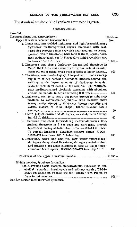
GEOLOGY OF THE FRESHWATER BAY AREA C35
The standard section of the lyoukeen formation is given:
Standard section Covered.lyoukeen formation (incomplete) : Thickness
Upper limestone member (incomplete): (feet)7. Limestone, interbedded light-gray and light-brownish-gray;
light-gray medium-grained sugary limestone with scat tered fine porosity; light-brownish-gray medium- to coarse grained clastic limestone; beds 3-10 ft thick; sparse dark- gray nodular chert, partly bleached to light-brownish-gray, in lenses 0.3-0.5 ft thick____________________ 1, 000+
6. Limestone and chert; dark-gray fine-grained limestone in 2-4-ft thick beds and dark-gray irregular beds of nodular chert 0.1-0.3 ft thick; cross beds of chert in many places. _ 400
5. Limestone, medium-dark-gray, fine-grained, in beds averag ing 2 ft thick; contains abundant lithostrotionoid and solitary corals, lesser amounts of dark-gray irregular nodular chert in lenses 0.1-0.3 ft thick, and light-brownish- gray medium-grained bioclastic limestone with abundant crinoid columnals, in beds averaging 3 ft thick 750
4. Limestone, similar to unit 5 but partly altered to light-gray medium- to coarse-grained marble with nodular chert lenses partly altered to light-gray fibrous tremolite and calcite masses of same shape; lithostrotionoid corals common______________________________ 60
3. Chert, grayish-brown and dark-gray, in cobbly beds averag ing 0.3 ft thick_________________________ 40
2. Limestone and chert interbedded; medium-dark-gray fine grained limestone in 2-4-ft beds and dark-gray, grayish brown-weathering nodular chert in lenses 0.3-0.4 ft thick; 75 percent limestone; abundant solitary corals; USGS- 18371-PC from level 100 ft below top___________ 600
1. Limestone, chert, and argillite, very thinly interbedded; dark-gray fine-grained limestone; dark-gray nodular chert and grayish-black shaly siltstone in beds 0.1-0.2 ft thick; abundant brachiopods; USGS-18372-PC from top 10 ft__ 100
Thickness of the upper limestone member._____________ 2, 955+
Middle member, lyoukeen formation:Shale, grayish-black, massive, noncalcareous, subflssile to con-
choidal; abundant brachiopods and solitary corals; USGS- 18374-PC about 400 ft from the top; USGS-18375-PC 500 ft from top of member________________________ 500+
Faulted section total thickness unknown.
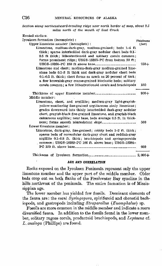
C36 MINERAL RESOURCES OF ALASKA
Section along northeastward-trending ridge near north border of map, about 3.5 miles north of the mouth of Seal Creek
Eroded surface.lyoukeen formation (incomplete) : Thickness
Upper limestone member (incomplete) : (feet) Limestone, medium-dark-gray, medium-grained; beds 1-4 ft
thick; sparse interbedded dark-gray nodular chert beds 0.1- 0.5 ft thick; lithostrotionoid and solitary corals common; forms prominent ridge; USGS-18385-PC from bottom 20 ft; USGS-18386-PC 150 ft above base_______________ 750+
Limestone and chert; medium-dark-gray medium-grained lime stone beds 0.1-3 ft thick and dark-gray nodular chert beds 0.1-0.5 ft. thick; chert forms as much as 20 percent of unit; a few brownish-gray coarse-grained bioclastic beds; solitary corals common; a few lithostrotionoid corals and brachiopods 150
Thickness of upper limestone member 900+ Middle member:
Limestone, chert, and argillite; medium-gray light-grayish- yellow-weathering fine-grained argillaceous shaly limestone; grades downward into thinly interbedded dark-gray nodular chert, grayish-black fine-grained limestone, and grayish-black calcareous argillite; near base, beds average 0.5 ft. in thick ness; forms smooth nonresistant slope_____________ 500
Lower limestone member:Limestone, dark-gray, fine-grained; cobbly beds 1-2 ft. thick;
sparse beds of nonnodular dark-gray chert and reddish-gray argillite 0.1-0.5 ft. thick; brachiopods and syringoporoids common; USGS-18383-PC 100 ft. above base; USGS-18384- PC 150 ft. above base______________________ 600
Thickness of lyoukeen formation_________________ 2,000+
AGE AND CORRELATION
Rocks exposed on the lyoukeen Peninsula represent only the upper limestone member and the upper part of the middle member. Older beds crop out on both flanks of the Freshwater Bay syncline in the hills northwest of the peninsula. The entire formation is of Missis- sippian age.
The lower member has yielded few fossils. Dominant elements of the fauna are: the coral Syringopom, spiriferoid and chonetid bach- iopods, and gastropods including Straparollm (Euomphalus) sp.
Fossils are more common in the middle member and indicate a more diversified fauna. In addition to the fossils found in the lower mem ber, solitary rugose corals, productoid brachiopods, and Leptaeno, cf. L. analog a (Phillips) are found.
GEOLOGY OF THE FRESHWATER BAY AREA C37
The lower two members are of Early Mississippian age and contain fossils similar to those collected from the Kayak shale and Wachsmuth limestone in northern Alaska (Bowsher and others, 1957, p. 5). The faunas also resemble, in a general way, those of the Lodgepole lime stone in Montana and the Banff formation in Alberta.
The upper member, composed of massive cherty limestone beds, is extremely fossiliforous. Lithostrotionoid corals and a variety of large horn corals are found at nearly every outcrop. The only other genus widely represented is G-igantoproductus, a large brachiopod that in so many places is associated with the coralline assemblages of Late Mississippian age in Alaska and the Pacific Northwest.
These fossils indicate rather close correlation with the Alapah lime stone of northern Alaska, the Rundle formation of Alberta, and the Brazer formation as it has been interpreted in southeastern Idaho (Mansfield, 1927, p. 63-71).
No beds of definitely post-Mississippian age are known to be in the Freshwater Bay area. The gypsiferous strata that appear to overlie the fossiliferous beds of the upper limestone may be younger, but no fossils have been recovered from them.
QUATERNARY DEPOSITS
Undifferentiated gravel, sand, silt, and talus debris are mapped as a single unit on plate 1. Glacial, alluvial, and colluvial deposits were not studied in detail or separated in mapping. To a large extent the boundaries of the areas included in this map unit were delineated from aerial photographs.
INTRUSIVE IGNEOUS ROCKS
Five plutonic igneous bodies crop out within or border on the Freshwater Bay area. The two larger bodies range from quartz mon- zonite to granite in composition. The three smaller bodies range in composition from diorite to quartz diorite. Significant data concern ing these plutons are summarized in table 2. Not included in this summary are the small intrusive bodies associated with volcanic rock of the Freshwater Bay formation and described with the rocks of this formation. The classification of igneous rocks of Williams and others (1954, p. 3-149) has been followed.
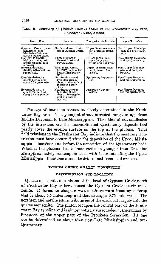
C38 MINERAL RESOURCES OF ALASKA
TABLE 2. Summary of plutonic igneous bodies in the Freshwater Bay area, Chichagof Island, Alaska
Description
Gypsum Creek quartzmonzonite (hom-blende-biotite), areaabout 4 square miles.
Hornblende granite,highly variable, onlyborder mapped; areaunknown.
Hornblende-augite diorite, area about 0.75square mile.
Hornblende-blotitequartz diorite, areaabout 0.6 square mile.
Homblende-biotite-quartz diorite, area about 0.3 square mile.
Location
North and west drainage of Gypsum Creek.
Tipper drainage ofKennel Creek andPavlof River.
West of Seal Creek, 1.5 miles north of thehead of FreshwaterBay.
Near headwaters oflyouktug Creek,about 1 mile south ofthe north borderof map.
Near headwaters oflyouktug Creek, about 1 mile northwest of previouslocation.
Youngest strata intruded
Upper limestone member, lyoukeen formation.
Kennel Creek limestone (only partwithin area observed).
Upper limestone mem ber, lyoukeen formation.
Freshwater Bay formation.
Freshwater Bay formation.
Age of intrusion
Post-Upper Misslssip-pian and pre-Quater-nary.
Post-Middle Devonianand pre-Quaternary.
Post-Upper Mississip- pian and pre-Quaternary.
Post-Upper Devonianand pre-Quaternary.
Post-Upper Devonianand pre-Quatemary.
The age of intrusion cannot be closely determined in the Fresh water Bay area. The youngest strata intruded range in age from Middle Devonian to Late Mississippian. The oldest strata unaffected by the intrusions are the unconsolidated Quaternary deposits that partly cover the erosion surface on the top of the plutons. Thus field relations in the Freshwater Bay indicate that the most recent in trusion must have occurred after the deposition of the Upper Missis sippian limestone and before the deposition of the Quaternary beds. Whether the plutons that intrude rocks no younger than Devonian are approximately contemporaneous with those intruding the Upper Mississippian limestone cannot be determined from field evidence.
GYPSUM CREEK QUARTZ MONZONITE
DISTRIBUTION AND LOCATION
Quartz monzonite in a pluton at the head of Gypsum Creek north of Freshwater Bay is here named the Gypsum Creek quartz mon zonite. It forms an elongate west-northwestward-trending outcrop that is about 5.5 miles long and that averages 0.75 mile wide. The northern and northwestern tributaries of the creek cut largely into the quartz monzonite. The pluton occupies the central part of the Fresh water Bay syncline and is almost entirely surrounded at the surface by limestone of the upper part of the lyoukeen formation. Its age can be determined no closer than post-Late Mississippian and pre- Quaternary.
GEOLOGY OF THE FRESHWATER BAY AREA C39
PETKOGBAPHT
The normal quartz monzonite in hand specimen is light gray, equigranular, medium grained, and rather homogeneous. This rock- type forms the bulk of the pluton, and border phases compose a rela tively minor percentage of the exposed rock. In thin section the normal quartz monzonite shows a hypidiomorphic granular texture consisting of the following minerals: anhedral slightly sericitized oligoclase ranging from An30 at the core to An15 near the edge; large (as much as 3 mm long) anhedral slightly kablinized potassic feldspar phenocrysts; euhedral green hornblende; frayed plates of reddish- brown biotite; and minor amounts of sphene, muscovite, apatite, and iron-ore minerals. In some specimens the hornblende is partly altered to biotite that, in turn, is partly altered to chlorite. Average visual estimates of mineral components are: plagioclase, 42 percent; potassic feldspar, 25 percent; quartz, 18 percent; biotite, 7 percent; hornblende, 6 percent; and minor accessories, 3 percent. An average plagioclase-potassic feldspar ratio of less than 2:1 places these rocks well within the quartz monzonite range (Williams and others, 1954, p. 121, 131). The potassic feldspar, either untwinned or carlsbad twinned, shows little or no perthitic intergrowth.
The border facies of Gypsum Creek quartz monzonite range con siderably in composition and texture within short distances. A few of the more important variants are described as follows.
Diopside-bearing monzonite and diorite occur along the edge of the pluton near the limestone contact at the headwaters of the tributary to Gypsum Creek which trends N. 70° W. These rocks are highly variable both in composition and grain size. In hand specimen they are light gray with prominent medium-green diopside crystals rang ing from 0.5 to 1 mm in length. Thin sections show a hypidiomor phic granular texture composed of euhedral diopside and green horn blende, laths of plagioclase ranging from An25 to An35 , anhedral grains of potassic feldspar, shreds of dark-brown biotite and minor epidote, chlorite, sphene, and sericite. In some sections the horn blende has partly replaced the pyroxene, which may in part be diop- sidic augite.
A small granophyric apophysis was observed within the upper lime stone member of the lyoukeen formation near the northern contact of the pluton at the head of the tributary of Gypsum Creek which trends N. 70° W. In hand specimen this rock is very light gray to white, porphyritic, and fine grained. In thin section it appears to be composed of euhedral to anhedral quartz, potassic feldspar, and oligo clase phenocrysts as much as 1 mm long in a wormy granophyric intergrowth of quartz and potassic feldspar and a few fine shreds of
C40 MINERAL RESOURCES OF ALASKA
biotite and muscovite. The average grain size of the rock is about 0.06 mm. A plagioclase-potassic feldspar ratio of about 1:4 indicates that the rock is probably granitic.
Another leucocratic f acies occurs within the northern border of the pluton, about 1 mile southeast of the granophyre. This rock is white and generally medium grained but has considerable variation in grain size. In thin section it appears to be a hypidiomorphic granular rock composed of a few euhedral plagioclase and anhedral quartz crystals surrounded largely by a plagioclase-quartz myrmekite. The remain ing mineral components, less than 5 percent, are sphene, zircon, and chlorite. The gram size ranges from 0.35 to 1 mm. The plagioclase generally displays albite twinning and is slightly sericitized; its com position ranges from An1B to An20 . The leucocratic character of the rock and the lack of potassic feldspar suggest its classification as a leucocratic diorite or trondhjemite (Williams and others, 1954, p. 109-110).
CONTACT METAMORPHISM
The zone of contact metamorphism of the Gypsum Creek pluton is relatively narrow. Limestone, which forms most of the intruded country rock at the surface, is recrystallized for several tens of feet away from the intrusive contact. The actual contact, however, be tween metasedimentary and plutonic igneous rocks is sharp. Wol- lastonite marble occurs within a few feet of the contact, whereas trem- olite marble is more common at greater distances. Tremolite-bearing marble is common in the upper limestone member exposed along the ridge south of the upper part of Gypsum Creek even though in places this exposure is more than a mile from the surface igneous contact. The pluton probably underlies this ridge at a relatively shallow depth. Nodular chert in the limestone on this ridge is altered to a mixture of tremolite needles and calcite. The altered nodules frequently retain a chert core.
Other minerals observed in small deposits at or near the contact of the pluton and limestone are: white euhedral diopside crystals, mas sive redish-brown anhedral andradite garnet, epidote, and minor amounts of iron-ore minerals (mostly pyrite). These tactite deposits are sparse and are only a few inches thick at most.
PLUTON AT THE HEAD OF KENNEL CREEK
The border zone of what appears to be a major plutonic intrusive body crops out for a distance of about 3.5 miles along the southwest margin of the map area in the upper drainage of Kennel Creek. The size of this body is not known, but exploratory traverses indicate that it may extend several miles to the southwest. The border zone rock
GEOLOGY OF THE FRESHWATER BAY AREA C41
is extremely variable both in composition and texture and cannot be considered characteristic of the plutonic body as a whole. Individual rock types are intertongued on such a small scale that no attempt was made to map them separately.
In general, the rock is rich in potassic feldspar that is commonly perthitic and includes large anhedral grains of microcline. The re maining constituents are: zoned plagioclase ranging from about An35 in cores to An15 near the edge; quartz (generally more than 20 per cent) ; green hornblende (generally euhedral); and minor amounts of zircon, sphene, apatite, biotite (after hornblende), chlorite, and iron- ore minerals. These components range widely in proportions and in grain size. The rock ranges from normal hypidiomorphic granular medium-grained granite containing less than 10 percent mafic minerals to very coarse grained hornblende-potassic feldspar-plagioclase-epi- dote pegmatitic rock in which the hornblende comprises more than 70 percent of the total rock. In the pegmatitic rock the hornblende is in elnogate euhedral crystals, averaging 2 inches long, and the otf 1* minerals fill the angular interstices.
One exception to the general potassic-rich composition of the border facies is a normal-appearing hornblende diorite. It exhibits a me dium-grained hypidiomorphic granular texture composed of zoned plagioclase laths ranging in composition from An35 at the core to An15 near the edge; minor interstitial quartz; euhedral green hornblende; and minor sphene, rutile, zircon, iron ore-minerals, and augite (partly altered to hornblende). With the possible exception of the cores of the plagioclase crystals, there is no potassic feldspar. The cores, stained yellow by the potassium cobaltinitrite stain method, are prob ably composed of potassic feldspar. According to Williams and others (1954, p. 131), the mantling of oligoclase around an orthoclase core (rapakivi texture) may indicate the basification of partly crystal lized magma by assimilation of andesitic wall rocks. Certainly the dioritic facies in which the rapakivi texture occurs is more basic than the other border facies examined and may be a basification product.
CONTACT MBTAMORPHISM
Thinly laminated alternate light- and dark-gray argillite and the overlying massive Kennel Creek limestone are intruded by the pluton north of the valley of Kennel Creek. Along this contact the argillite occurs both at the margin of the pluton and within it as sliverlike roof pendants, whereas the limestone is largely confined to the border zone itself. The contact between plutonic igneous rock and metasedi- mentary rock is sharp.
The width of the contract zone is not accurately known because of poor exposures, but it appears to be at least several tens of feet wide.
C42 MINERAL RESOURCES OF ALASKA
At the contact the argillite has been converted to a light- and dark- banded fine-grained hornblende-biotite-oligoclase hornfels containing variable amounts of quartz. The dark bands are rich in hornblende and biotite and represent former claystone laminae, whereas the light bands are rich in feldspar and quartz and represent former siltstone or very fine grained sandstone.
The massive limestone near the contact has been recrystallized to a white very coarse grained marble with an average grain size of about 10 mm. The grain size of the marble appears to decrease away from the contact. Calcsilicate minerals were not observed in the marble.
SMALL PLUTONS
Three small plutons crop out northeast of the head of Freshwater Bay. The shape and contact relations of these plutons are not ac curately known owing to the lack of exposures, but, in general, they appear to be crosscutting pluglike bodies.
The largest of the three plutons crops out near the (crest of the northwestward-trending ridge about 1.5 mile north of the head of Freshwater Bay near the headwaters of Seal Creek. It intrudes the limestone and shale of the lyoukeen formation and probably the vol canic rock of the Freshwater Bay formation, forming an outcrop about 1 mile long 0.75 mile wide.
In hand specimen the normal rock of this pluton is medium gray and medium grained with prominent hornblende and augite pheno- crysts averaging about 1 mm in diameter. In addition, there is a greenish-gray finer grain phase in which the mafic minerals have indistinct borders and are moderate green.
In thin section the normal rock appears to be a diorite with a nearly panidiomorphic-granular texture. It contains euhedral pheno- crysts of brownish-green horn'blende and slightly uralitized augite, ranging from 1 to 2 mm in length, in a groundmass of slightly smaller laths of zoned partly sericitized plagioclase, ranging in composition from An35 to An40, with minor amounts of dark-reddish-brown biotite (after hornblende), chlorite, apatite, and iron-ore minerals. Visual estimates of the mineral component percentages are: plagioclase, 60 percent; hornblende, 25 percent; augite, 5 percent; biotite, 3 percent; and all others 7 percent.
In thin section the greenish-gray phase appears to have been strongly uralitized. The euhedral augite crystals have been altered almost completely to a pale-green amphibole. This amphibole occurs as anhedral patches in and around the remnants of the augite crystals. No primary hornblende is present in this phase, but the plagioclase and minor accessory minerals are the same as those of the normal diorite.
GEOLOGY OF THE FRESHWATER BAY AREA C43
Although the borders of this pluton are poorly exposed, the contact with limestone and shale of the lyoukeen formation was observed in a few places and appears to be sharp. In and near the contact the limestone has been recrystallized to marble that, in places, is tremolite bearing. Small, sparse deposits of reddish-brown andradite garnet, epidote, scapolite, pyrite, arid minor amounts of magnetite, generally not over a few inches wide, were also observed in and near the contact of the marble and cliorite. Where the diorite has intruded shale, the shale has been converted to a dark-gray hornblende-biotite hornfels.
Two smaller plutons crop out on subparallel north-northeastward- trending ridges about 4 miles northeast of the diorite near the head waters of lyouktug Creek. The northwesternmost of the two bodies intrudes the lower part of the Freshwater Bay formation; the south eastern body intrudes along the contact between the Freshwater Bay formation and the Kennel Creek limestone. Each pluton crops out for about 1,000 feet along the ridges on which they are exposed, but be cause of poor exposures other dimensions were not determined.
Typically the rock of both plutons is quartz diorite, which in hand specimen is medium gray, medium grained, and equigranular with conspicuous dark grains of hornblende and biotite. In thin section a typical specimen shows a hypidiomorphic granular texture consisting of: laths of zoned albite-twinned moderately sericitized plagioclase; interstitial clear quartz; anhedral bluish-green hornblende, slightly altered to biotite; dark-reddish-brown shreds of biotite; and minor amounts of sphene, apatite, and iron-ore minerals. Visual estimates of mineral component percentages are: plagioclase, 50 percent; quartz, 15 percent; hornblende, 20 percent; biotite, 10 percent; and all others 5 percent. The plagioclase averages about An 50 near the center of grains and An 35 near the edges. Average grain size is about 0.75 mm in diameter.
Because the contracts of both plutons are poorly exposed, little in the way of contact metamorphism was observed. The southeastern pluton has recrystallized the Kennel Creek limestone to a white medium crystalline marble near the contact, but the width of the contact zone is not known.
DIKES AND SILLS
Numerous dikes and sills, some of post-Mississipian age, intrude the rocks of the Freshwater Bay area. Descriptions of some of the more common types are summarized as follows.
ANDESITE DIKES AND SILLS
A complex of dikes and sills, ranging from 6 inches to 30 feet in thickness intrudes the middle member of the lyoukeen formation on
C44 MINERAL RESOURCES OF ALASKA
the first ridge northeast of Freshwater Bay. Most of these rocks are andesite, but a few felsite dikes occur among them. In general, the dikes strike N. 25° W. and dip 30° NE., whereas the sills, in parallel ing the bedding, strike N. 30° E. and dip 30° SE. There is, however, much irregularity of attitude.
In hand specimen the andesitic rock is dark grayish brown and consists of conspicuous euhedral hornblende phenocrysts, averaging about 3 mm long, embedded in an aphanitic groundmass. Thin sec tions show phenocrysts of strongly sericitized plagioclase and euhe dral greenish-brown hornblende in a groundmass of stubby microlites of plagioclase and hornblende, together with interstitial chlorite and sericite. The plagioclase crystals are zoned from An 30 to An 40 near the core to An 15 to An 20 near the edges; albite twinning is common. The hornblende is mostly brown with green rims and spots; it is com monly altered to chlorite.
The felsite is aphanitic, very light gray on fresh fracture and brownish red on weathered surfaces. In thin section it appears to consist of irregular remnants of feldspar phenocrysts in a very fine grained cloudy felty groundmass of sericite and disseminated pyrite. The feldspar is too much altered to be identified. Fine mosaic quartz occurs both in veinlets and in the rock surrounding the veinlets.
SPESSARTITE LAMPRCKPHYRB
A single sillike intrusive igneous body crops out 3% miles north of the mouth of Seal Creek in a narrow saddle on a major northeast ward-trending ridge. (See pi. 1.) The body is about 150 feet thick and 1,000 feet long and intrudes the lyoukeen formation near the con tact between the middle member and the lower limestone member. Contact relations are not clear, but the intrusion appears to parallel the bedding of the sedimentary rock and may be a sill.
In outcrop the igneous rock is not readily differentiated from the limestone and shale that it intrudes. Both igneous and sedimentary rocks near the contact weather with rough brownish-gray surfaces.
In thin section the igneous rock displays a porphyritic texture con sisting of abundant needles of reddish-brown hornblende in a cloudy indistinct groundmass composed of anhedral oligoclase, indistinct potassic feldspar, hornblende microlites, chlorite, and iron-ore min erals. The plagioclase-potassic feldspar ratio is about 4:1. Both composition and texture indicate a spessartite lamprophyre (Williams and others, 1954, p. 84-89).
The limestone for several tens of feet on each side of the igneous rock is fractured and recrystallized. The altered limestone weathers to a brownish-gray rough spongy surface. In thin section it appears
GEOLOGY OF THE FRESHWATER BAY AREA C45
to be composed of calcite, pyrite, and abundant brown cloudy non- biref ringent material.
STRUCTURE
FRESHWATER BAY SYNCLINE
The Freshwater Bay syncline, named by Buddington and Chapin (1929, p. 315), is the major structural feature of the mapped area. The plunge of the structure is southeastward less than 10°. The general dip of the limbs is approximately 45°. The trough of the syncline at lyoukeen Cove comprises the youngest strata of the mapped area, the upper gypsiferous part of the lyoukeen formation. The axis of the syncline is offset left-laterally by eastward-striking faults. The southwest flank is further complicated by a northwest ward-striking fault system. The northeast flank has been locally complicated by thrusting from the northeast. Intrusion of the trough of the syncline by the Gypsum Creek quartz monzonite was apparently accompanied by minor marginal thrusting. Small remnants of folded Mississippian strata, now roof pendants within the intrusive body, ap pear to have been carried or pushed upward from their normal posi tion deep in the trough of the syncline.
FAULTS AND LINEAMENTS
Within the Freshwater Bay area, faults have been identified and examined locally. Their exposure is generally poor in this heavily timbered and glaciated area, and their location and the nature of move ment can generally be inferred only from the distribution of strati- graphic units. Many lineaments, some of which have been identified as faults in the field, are clearly expressed on aerial photographs. These lineaments are interpreted as probable surface expressions of faults or shear zones. They are commonly troughlike depressions a few tens of feet wide to which drainage has adapted itself. Run ning water and other agents of erosion have further accentuated these zones by removal of rock that has been crushed by faulting. The faults shown on the geologic map (pi. 1) have been divided into two groups: (1) Faults based on field evidence; (2) faults based on photo- interpretation. The location of the second group was derived from linear features expressed on aerial photographs. Faults and linea ments may be summarized and generally described in the following sets: (1) Eastward-striking faults and associated lineaments; (2) northwestward-striking faults and associated lineaments; (3) north westward-striking thrust faults; and (4) marginal thrust faults near intrusive bodies.
C46 MINERAL RESOURCES OF ALASKA
Eastward-striking left-lateral faults and associated lineaments are prominent only in that area bounded by Freshwater Bay on the south, the North Shore fault on the west, and the valley of lyouktug Creek on the northeast. Within this area, the eastward-striking fault set has offset all exposed strata between and including the Kennel Creek limestone and the lyoukeen formation subsequent to their folding. This set is not observed to cut the quartz monzonite intrusive body but is present both east and west of the Gypsum Creek quartz mon zonite body. The most prominent of the set is the lyouktug fault whose apparent horizontal displacement is approximately 1 mile, with the north block moved westward. Minor faults both north and south of the lyouktug fault show either an apparent vertical dis placement downward with the north block or an apparent left-lateral horizontal displacement.
NORTHWESTWARD-STRIKING FAUI/TS AND ASSOCIATEDLINEAMENTS
Northwestward-striking faults and associated lineaments form a wide zone along both the north and south shores of Freshwater Bay on the west limb of Freshwater Bay syncline. This fault system off sets all strata exposed in the Freshwater Bay area. No lineaments can be traced across the Gypsum Creek quartz monzonite other than what appears on aerial photographs to be a joint set not mapped but roughly parallel to and possibly related to northwestward-striking faults. Northward-trending lineaments, vaguely to well expressed on aerial photographs northwest of the head of Freshwater Bay, may represent splits and joins within this system, but their nature has not been ascertained by field observation. Similarly the significance of several northward-trending lineaments across the granite body west of Freshwater Bay has not been evaluated. On the west side of the syncline, a strongly expressed northwestward-striking system of faults appears to truncate all faults of the eastward-striking system. West of Freshwater Bay the northwestward-striking faults appear to be dominantly right lateral.
The North Shore fault has an apparent vertical displacement down ward on the west side, and cuts strata of the Freshwater Bay and lyoukeen formations on the west limb of the syncline. A complicated zone of parallel faults, splits, and joins borders the North Shore fault on the west. Block faulting is indicated (cross section G-C' of pi. 1) with, locally at least, some right-lateral horizontal displacement.
The Peninsula fault shows an apparent vertical displacement down ward on the north side bringing volcanic rock of the Freshwater Bay formation against all members of the lyoukeen formation. Its rela-
GEOLOGY OF THE FRESHWATER BAY AREA C47
tions to the North Shore fault zone and to the eastward-striking left- lateral faults are not known. Depth of water close to the southern shore of lyoukeen Peninsula indicates the probability that the fault extends along the peninsula and just offshore.
The North Fork fault has thrown Kennel Creek limestone against the volcanic rock of the Freshwater Bay formation. Distribution of mapped units indicates either right-lateral displacement, vertical dis placement with the east side downthrown, or a combination of the two Avth a horizontal component of displacement of approximately 1 mile. The Kennel Creek fault shows movement similar to the North Fork fault, with strata of the Cedar Cove formation against Kennel Creek limestone along strike but with slightly less horizontal displacement indicated. Neither fault has been carefully studied in the field.
The South Shore fault shows the greatest apparent horizontal dis placement of the faults in the northwestward-striking system. Right- lateral displacement, vertical displacement with east side downthrown, or a combination of the two is proposed to explain nearly 2V& miles of apparent horizontal displacement along the fault. Strata of the Kennel Creek, Cedar Cove, and Freshwater Bay formations are offset by the fault. The East Point fault may be an extension of the South Shore fault or may represent one of several splits from it. It is pre sumed to have a right-lateral component of movement in accord with what is known of the northwestward-striking system.
The Cedar Cove fault may represent the extension of the North Short fault, or a split from it, that has thrown Kennel Creek lime stone against volcanic rock of the Freshwater Bay formation, which strikes into the limestone across the fault. Distribution of mapped units indicates movement similar to other faults of the system.
The False Bay fault zone cannot be properly evaluated as to displacement and nature of movement with available data. North westward extension of the zone beneath Quaternary sediments is considered possible. The zone lies mainly within contorted and much- fractured argillite and graywacke, stratigraphically below the Kennel Creek limestone. At the north edge of the map area, steeply dipping clastic strata of the older argillite-graywacke unit have been thrown against gently dipping Kennel Creek limestone, possibly by a high- angle reverse fault.
NORTHWESTWARD-STRIKING THRUST FAUI/TS
Thrust faulting, with formations having been overridden by thrust plates from the northeast, seems indicated by the absence of at least 7,500 feet of strata normally present in the composite stratigraphic sequence of the Freshwater Bay area. Near the mouth of Wukuklook
C48 MINERAL RESOURCES OF ALASKA
Creek, Kennel Creek limestone abuts against the upper limestone member of the lyoukeen formation. The missing strata include at least 7,500 feet of volcanic rock of the Freshwater Bay formation and the two lower members of the lyoukeen formation. The suggested Wukuklook thrust zone appears to cross Sonyakay Ridge as a zone of parallel lineaments south of lyouktug fault and may extend into the valley of lyouktug Creek.
Thrusts along the west-northwestward-striking False Bay fault zone can neither be confirmed nor denied on the basis of present knowledge. However, the traces of the strongly expressed lyouktug fault do not appear northeast of the valley of lyouktug Creek. The thrusting probably postdated both the formation of the eastward- striking fault set and the emplacement of the Gypsum Creek quartz monzonite. The thrust zone appears to truncate the strongly expressed eastward-striking faults. The quartz monzonite body is presumed to have provided a buttress effect during the thrusting that may represent the latest major tectonic activity.
MARGINAL, THRUST FAULTS NEAR INTRUSIVE BODIES
Marginal thrust faults occur locally near the edges of the Gypsum Creek quartz monzonite. High-angle minor reverse faults separate thin plates of intricately drag-folded limestone near the sharply de fined north contact between the headwaters of Wukuklook Creek and the eastern tributary of Seal Creek. Here also the upturning of the strata against the contact of the intrusive body probably indicates forceful intrusion. Marginal thrusts are suspected but not proved to the south and east of the quartz monzonite pluton.
GEOLOGIC HISTORY
In pre-Middle Devonian time, perhaps in the Silurian or Early Devonian, an apparently unfossiliferous sequence of interbedded muddy sands and muds, more than 5,000 feet thick accumulated in a subsiding trough or basin.
The muddy sands were deposited periodically by mud-choked cur rents, possibly in quiet water below wave base. The source must have been an area of high relief from which rapid erosion and transporta tion delivered an abundance of nearly unweathered and poorly sorted material to the site of deposition. Most likely the mud beds also were deposited in quiet water. Because they show no signs of current ac tion, they probably settled from standing water between periodic episodes of sand deposition.
Near the end of the clastic deposition, coarse sand, gravel, and boulder beds were deposited along the southern border of the area.
GEOLOGY OF THE FRESHWATER BAY AREA C49
This probably reflected nearby uplift, which may have marked the beginning of a more widespread uplift resulting in the emergence and subsequent erosion of the Freshwater Bay area. In any case, clastic sedimentation ended after the deposition of these coarse elastics.
In the Middle Devonian, following uplift and possible erosion, a subsiding marine trough again occupied the Freshwater Bay area. The landmass that had supplied the clastic debris was by this time either reduced to low relief or completely submerged. In either case, carbonate deposition prevailed in the area. Continued subsidence al lowed several thousand feet of limestone, the Kennel Creek limestone, to accumulate.
Near the close of the period of deposition of the Kennel Creek lime stone, very thin layers of clay, possibly representing ash from distant volcanic eruptions, were deposited periodically.
The beginning of the deposition of the Cedar Cove formation was marked by an influx of clastic debris, probably due to uplift of a nearby volcanic terrain. Mud, sand, and gravel were interbedded with limestone in the early stages. Later, during the deposition of the upper part of the lower member of the Cedar Cove formation, only clastic sediment was deposited. About 1,500 feet of clastic sedi ment and limestone accumulated before the influx of clastic debris ceased. Cessation of uplift and the reduction of the source area to a region of low relief probably caused a termination of clastic deposition.
An episode of predominantly carbonate deposition followed during which more than 1,000 feet of limestone with a minor amount of dolomite and tuff (the upper member of the Cedar Cove formation) accumulated. Periodic volcanism, presumably in the source area, oc curred during the deposition of the middle part of the upper member, but carbonate deposition remained dominant. Middle Devonian sedi mentation apparently ended with uplift, emergence, and erosion in the Freshwater Bay area.
Following a period of erosion during which in places the entire Cedar Cove formation and a part of the upper Kennel Creek lime stone may have been removed, an episode of volcanic activity be gan. In the Late Devonian more than 6,500 feet of highly variable volcanic rocks and associated sediment of the Freshwater Bay forma tion were deposited in a subsiding basin or trough that was, at least in part, marine. During the volcanism numerous dikes and sills, prob ably in part volcanic feeders, cut the underlying rocks. The Upper Devonian record ends with the cessation of volcanism, emergence of the land, and erosion.
In early Mississippian time, subsidence and encroachment of the sea resulted in renewed marine sedimentation. The predominant
C50 MINERAL RESOURCES OF ALASKA
carbonate deposition indicates that the source areas were either of low relief or distant. After about 600 feet of limestone composing the- lower limestone member of the lyoukeen formation had accumulated, uplift in the source area, possibly to the east, produced a supply of clastic material. Mud was deposited in the southeastern two-thirds of the area, while carbonate was being deposited in the northwestern third.
By Late Mississippian time, the source area was reduced to a region of low relief and carbonate deposition was resumed. Subsidence of the sea floor allowed more than 3,000 feet of limestone, the upper lime stone of the lyoukeen formation, to be deposited. The record of pre- Quaternary sedimentation ends with the deposition of this limestone.
After the deposition of the Late Mississippian strata, stresses acting upon the area produced major southeastward-plunging folds. Later deformation developed an eastward-striking fault set displacing these major folds. During or after this deformation, the sedimentary strata were invaded by igneous material. Within this episode of intrusive activity, all the granitic and dioritic intrusive bodies may have been created. Emplacement of the Gypsum Creek quartz monzonite appears to have been accompanied by marginal thrusting. Subsequent deformation developed a northwestward-striking system of right-lateral faults truncating the eastward-striking set. Thrust faulting from the northeast is postulated as the final major recordable tectonic event in the area.
In summary, the suggested sequence is:
1. The development of an eastward-striking fault set, displacing folded Mississippian and older formations.
2. Marginal thrusting during emplacement of the Gypsum Creek quartz monzonite.
3. The development of a northwestward-striking fault system, trun cating the eastward-striking fault set.
4. Thrust faulting from the northeast, covering the eastward exten sions of eastward-striking faults and riding over a considerable thickness of Devonian rocks.
Although uplift, which probably accompanied this episode of defor mation, undoubtedly initiated a cycle of erosion, present-day topogra phy may be the result of a later cycle of uplift and erosion. In the Quaternary, glaciers reshaped terrain and deposited glacial gravels, sand, and silts in the valleys and lowlands.
Today, with the glaciers gone, streams are modifying the land scape cutting away the hills, filling in the valleys, and building deltas at their mouths.
GEOLOGY OF THE FRESHWATER BAY AREA C51
LITERATURE CITED
Bowsher, A. L., Dutro, J. T., Jr., and Patton, W. W., Jr., 1957, Exploration of Naval Petroleum Reserve No. 4 and adjacent areas, northern Alaska, 1944-53, pt. 3: U.S. Geol. Survey Prof. Paper 303-A and B, 45 p.
Brooks, A. H., and others, 1906, Progress of investigations of mineral resources of Alaska in 1905: U.S. Geol. Survey Bull. 284,169 p.
1907, Progress of investigations in mineral resources of Alaska in 1906: U.S. Geol. Survey Bull. 314, 235 p.
1908, Progress of investigations in mineral resources of Alaska in 1907:U.S. Geol. Survey Bull. 345, 294 p.
Buddington, A. F., and Chapin, Theodore, 1929, Geology and mineral depositsof southeastern Alaska: U.S. Geol. Survey Bull. 800, 398 p.
Correns, C. W., 1950, Zur Geochemie der Diagenese, I Das Verhalten von CaCO3und Si02 : Geochim. Cosmochini. Acta. v. 1, p. 49-54.
Eminons, R. C., and Gates, R. M., 1948, The use of Becke line colors in refractiveindex determination: Am. Mineralogist, v. 33, nos. 9-10, p. 612-618.
Flint, G. M., Jr., and Cobb, E. H., 1953, Gypsum deposits near lyoukeen Cove,Chichagof Island, southeastern Alaska: U.S. Geol. Survey Bull. 989-B, 37 p.
Kindle, E. M., 1907, Notes on the Paleozoic faunas and stratigraphy of south eastern Alaska: Jour. Geology, v. 15, no. 4, 314-337.
Kirk, Edwin, 1918, Paleozoic glaciation in southeastern Alaska: Am. Jour. Sci.,4th ser., v. 46, no. 273, p. 511-515.
1927a, Pycnodesma, a new molluscan genus from the Silurian of Alaska: Natl. Mus. Proc., v. 71, art. 20, p. 1-9.
1927b, Pycinodesma, new name for Pycnodesma, Kirk not Schrammen:Washington Acad. Sci. Jour., v. 17, no. 21, p. 543.
Knopf, Adolph, 1912, The Sitka mining district, Alaska: U.S. Geol. Survey Bull. 504, 32 p.
Krynine, P. D., 1948, The microscopic study and field classification of sedimen tary rocks: Jour. Geology, v. 56, no. 2, p. 130-165.
Kuenen, Ph. H., 1953, Significant features of graded bedding: Am. Assoc. Petro leum Geologists Bull., v. 37, no. 5, p. 1044-1066.
1957, Sole markings of graded graywacke beds: Jour. Geology, v. 65, no. 3, p. 231-258.
Mansfield, G. R., 1927, Geography, geology, and mineral resources of part of southeastern Idaho: U.S. Geol. Survey Prof. Paper 152,453 p.
Nolan, T. B., 1935, The Gold Hill mining district: U.S. Geol. Survey Prof. Paper 177,172 p.
Pettijohn, F. J., 1957, Sedimentary rocks: New York, Harpers and Bros., 718 p.Rodgers, John, 1940, Distinction between calcite and dolomite on polished sur
faces : Am. Jour. Sci., v. 238, p. 788-798.Smith, P. S., 1932, Mineral resources of Alaska in 1929: U.S. Geol. Survey Bull.
824,109 p.Wentworth, C. K., 1922, A scale of grade and class terms for clastic sediments:
Jour. Geology, v. 30, p. 377-392.Wentworth, C. K., and Williams, Howel, 1932, The classification and terminology
of the pyroclastic rocks: Natl. Research Council Bull. 89, p. 19-53.Williams, Howel, Turner, F. J., and Gilbert, C. M., 1954, Petrography, an intro
duction to the study of rocks in thin sections: San Francisco, W. H. Freeman and Co., 406 p.

INDEX
Pag*Age and correlation....____ C13,16,22,31,36
Ceda Cover formation. 22-23Freshwater Bay formation.. ... 31-32lyoukeen formation.___ 36-37Kennel Creek limestone__ 16-17Silurian or Devonian rocks..__.__,_ 13
Alapah limestone__________ _ 37Alexander Archipelago. ____ , 2Andesite dikes and sills... . 43-44Andesitic member, upper, Freshwater Bay
formation...___________ 28-29 Angoon, Admiralty Island.__ .... 3 Argillite and graywacke unit.. 11 Argillite and graywacke_______ __ 8 Argillite sequence- . 10,11 Arkosicgraywacke.._________ __ 9,10
Banff formation_ _____ _ 37Bedded rocks.. ... 6-37Bibliography..____________ _ 51Boat Harbor..... ..... ... 13Brazer formation..______________ 37
Cedar Cove........_....______ 14,17,23,25Cedar Cove fault. .. 47Cedar Cove formation. 6,13,14,15,17-23,31,33,47,49
age and correlation____________ 22-23distribution and topographic expression.. 17-18stratigraphy and petrography... . 18-22
Cedar Island....______________ 17,27,28Chatham Strait......_...__............. 3,7,14Climate of Freshwater Bay._... __ 3 Conglomerate at East Point__ . 12-13 Contact metamorphism._________ 40,41,43
Devonian or Silurian rocks______ __ 6-13Devonian rocks. _______________ 13-32Dikes and sills. _.______________ 43-45
andesite dikes and sills____ .... 43-44spessartite lamprophyre.._______ 44-45
Distribution and topographic expression..__ 6-8,13,17,23,32
Cedar Cove formation.........._ .... 17-18Freshwater Bay formation._______ 23 lyoukeen formation.___________ 32 Kennel Creek limestone____.. _ 13-14 Silurian or Devonian rocks________ 6-8
East Point.....__......_... 3,12,13,14,17,18,24East Point fault________________ 47
False Bay area________________ 8-11 False Bay............................ 6,7,8,9,10,13
argillite and graywacke sequence. .... 11 fault zone..._______________ 47,48
PaceFaults and lineaments...___.___ . C45-48 Faults, eastward striking and associated linea
ments.___________.__ 46 marginal thrust, near intrusive bodies.... 48northwestward striking__.___ __ 47 northwestward striking and associated
lineaments.-_______ __ 46 Fossils...................... 13,15,16,17,22,32,36,37Freshwater Bay formation __ 17,
18,23-32,37,42,43,46,47,48,49age and correlation...... ___ 31-32distribution and topographic expression.. 23 lower greenstone member....___ .. 24-25middle rhyolitic member.________ 25-28 northeast limb of Freshwater Bay syn-
cline________________ 29-31 southwest limb of Freshwater Bay syn-
cline____________ __ 24-29 stratigraphy and petrography._ 23-31 upper andesitic member_________ 28-29 volcanism___....________ __ 25
Freshwater Baysyncline_.. ___ 5,6,13,23,24,29,30,32,33,34,36,38,45,46
northeast limb______________ 29-31southwest limb_.________ __ 24-29
Freshwater Creek.__________.. 3,17,25,27
Geologic history____________ __ 48-50 Gold Hill district, Utah...................... 17Graywacke, arkosic. ___..___ __ 9,10
high rank.......... _..._._....... 10,20Greenstone, the term__________..__ 25 Gypsum Creek___________ 5,32,34,38,39,40 Gypsum Creek pluton....______ _. 40Gypsum Creek quartz monzonite___.__ 32,
34,38-40,45,46,48,50distribution and location_____~__ 38petrography __ _.. 39-40contact metamorphism_______.__ 40
Gypsum deposits.....____.____ ... 34-36
High-rank graywacke . . 10,20
Introduction..__ ___ ___ .... 2-4Intrusive igneous rocks..... _.. 37-45lyoukeen Cove___________ 4,5,18,32,34,45 lyoukeen formation....________ 23,24,30,
31,32-37,38,39,42,43,44,45,46,48,50age and correlation_________.__ 36-37distribution and topographic expression.. 32gypsum deposits... 34-36stratigraphy and petrography.__ _. 32-34
lyoukeen Peninsula... . 32,36,47lyouktug Creek.... .........- 3,8,10,18,43,46,48lyouktug fault............................ 46,48
C53
C54 INDEX
Juneau, Alaska.Page
03
Kayak shale._ - .... 37Kennel Creek.... 3,5,7,11,
12,13,14,15,17,18,19,21-22,24,40,41Kennel Creek fault. . . 17,47Kennel Creek limestone_____ 5,8,11,12,13-17,
18,20,23,31,33,41,43,46,47,48,49age and correlation.;___......... 16-17distribution and topographic expression.. 13-14stratigraphy -. 14-16
Kennel Creek pluton__.........._.. ... 40
Lodgepole limestone........._ ... 37Lower greenstone member, Freshwater Bay
formation.. ............. 24-25
Mlssissippian rocks. __.. ......... - 32-37
North Shore fault...__...._.___....... 46,47Northeast limb of Freshwater Bay syncllne.. 29-31
Paleozoic tillite. . 5 Pavlof Harbor...............-......... . 2,13Pavlof River...... . 3,7Pluton at the head of Kennel Creek_____ 40-42 Pluton, contact metamorphism 41-42 Plutons, small 42-43 Porphyrltlc andesite. 30 Port Frederick. ...................... 7,23,31,32Precipitation of Freshwater Bay....... 3Previous investigations of area. 4-5 Purpose and scope. 5-6
Quaternary deposits. 37,47
RedcliS Islands . ................. 25Rhyolitic member, middle, Freshwater Bay
formation.____________ 25-28 Bundle formation 37
Page St. James Bay........._...... _._.. C13Seal Creek... ..__............ 3,32,34,42,44,48Silurian or Devonian argillite and graywacke
sequence.______._____ 13,14 Silurian or Devonian rocks__________ 6-13 Sitka D-3 quadrangle..._...... _._.. 2,5Sitka D-4 quadrangle.____________ 3,5 Sitka spruce.. _...... .._.. 4Small plutons _________._____ 42-43 Sonyakay Mountain._____________ 23 Sonyakay Ridge...__._____.___ 14,18,48 South Fork of Freshwater Creek. _____.. , 3,11 South Shore fault. ______________ 14,47 Southwest limb of Freshwater Bay syncline.. 24-29 Southwest of Freshwater Bay________ 11-12 Spasski Creek.._______________ 32 Spessartite lamprophyre......._______ 44-45Stephen R. Capps, motor vessel_______ 6Stratigraphy and petrography__..__ 8,18,23,32
Cedar Cove formation..__ . ... 18-22Freshwater Bay formation.._______ 23-31lyoukeen formation.__________.. 32-34Silurian or Devonian rocks... . ... 8-13
Stratigraphy-___________._____ 14-16Structure...__________________ 45-48
Temperature of area_________.___ 4 Tenakee Inlet.. ..... .... 2-3,12 Thin sections of rock types. _________ 6
Unnamed argillite and graywacke........._ 6-13
Wachsmuth limestone---------- 37Wachusett Cove.. ________.... _ 24,25Wentworth grain size scale. ___ ......... 6Western hemlock......_____...... .. 4Wukuklook Creek......... 23,24,29,30,33,34,47-48Wukuklook thrust zone___________ 48
o