geology of the gascoyne province and preliminary ... · minnie creek-lyons river fault? ......
TRANSCRIPT

Government of Western Australia Department of Mines and Petroleum
Geological Survey of
Western Australia
Geology of the Gascoyne Province and preliminary interpretation of deep seismic reflection lines
10GA–CP2 and 10GA–CP3: crustal architecture of the Gascoyne Province
SP Johnson, HN Cutten, IM Tyler, RJ Korsch, AM Thorne, O Blay, BLN Kennett, RS Blewett, A Joly, MC Dentith, ARA Aitken, J Goodwin, M Salmon, A Reading, G Boren, J Ross, RD Costello
and T Fomin
Government of Western Australia Department of Mines and Petroleum Government of Western Australia Department of Mines and Petroleum Government of Western Australia Department of Mines and Petroleum
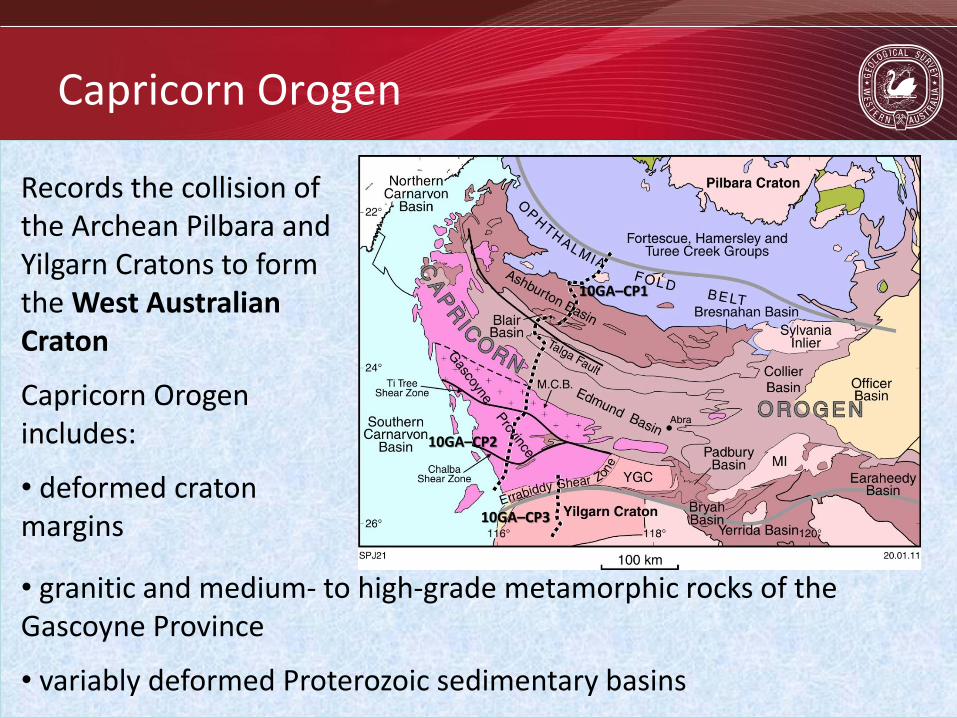
Capricorn Orogen
Records the collision of the Archean Pilbara and Yilgarn Cratons to form the West Australian Craton
Capricorn Orogen includes:
• deformed craton margins
• granitic and medium- to high-grade metamorphic rocks of the Gascoyne Province
• variably deformed Proterozoic sedimentary basins
10GA–CP1
10GA–CP2
10GA–CP3

Government of Western Australia Department of Mines and Petroleum Government of Western Australia Department of Mines and Petroleum Government of Western Australia Department of Mines and Petroleum
West Australian Craton
Assembled during two distinct and separate events. Three blocks, two collisions and therefore two suture zones.
• Collision of the Pilbara Craton with the oldest part of the Gascoyne Province (Glenburgh Terrane) during the 2215–2145 Ma Ophthalmian Orogeny. Suture is unexposed – Talga Fault?
• Collision of a combined Pilbara Craton – Glenburgh Terrane with the Yilgarn Craton during the 2005–1950 Ma Glenburgh Orogeny. Suture at the Errabiddy Shear Zone
10GA–CP1
10GA–CP2
10GA–CP3

Government of Western Australia Department of Mines and Petroleum Government of Western Australia Department of Mines and Petroleum Government of Western Australia Department of Mines and Petroleum
Gascoyne Province
• Following these collisions, the Gascoyne Province was subject to over one billion years of intracontinental reworking, including deformation, metamorphism and magmatism
• Series of fault or shear zone bounded structural – metamorphic – magmatic corridors
10GA–CP2
10GA–CP3

Government of Western Australia Department of Mines and Petroleum Government of Western Australia Department of Mines and Petroleum Government of Western Australia Department of Mines and Petroleum
Glenburgh Terrane
10GA–CP2
10GA–CP3

Government of Western Australia Department of Mines and Petroleum Government of Western Australia Department of Mines and Petroleum Government of Western Australia Department of Mines and Petroleum
Glenburgh Terrane
• Heterogeneous granitic gneisses (Halfway Gneiss) that predate both collisions, and which are exotic to the Pilbara and Yilgarn Cratons • Silisiclastic metasedimentary rocks of various age
• Moogie Metamorphics • Camel Hills Metamorphics
• Intermediate to felsic granitic batholith that formed in a continental margin arc leading up to the collision of the Pilbara Craton – Glenburgh Terrane with the Yilgarn Craton (Dalgaringa Supersuite)
10GA–CP2
10GA–CP3

Government of Western Australia Department of Mines and Petroleum Government of Western Australia Department of Mines and Petroleum Government of Western Australia Department of Mines and Petroleum
Glenburgh Terrane: an exotic crustal fragment
Halfway Gneiss • Heterogeneous granitic gneisses (2555–2430 Ma) • Inherited zircon and Hf-zircon model ages indicate an older crustal history as old as 3700 Ma • Isotopic evolution different to the Pilbara and Yilgarn Cratons • an exotic crustal fragment
Moogie Metamorphics • 2240–2125 Ma Moogie Metamorphics deposited during the 2215–2145 Ma Ophthalmian Orogeny • Contain detritus from both the unconformably underlying Halfway Gneiss and the Hamersley and Fortescue Basins and granite-greenstones of the Pilbara Craton • Pro-foreland basin of the Ophthalmian Orogeny • Pilbara Craton – Glenburgh Terrane collision during the Ophthalmian Orogeny
unconformity

Government of Western Australia Department of Mines and Petroleum Government of Western Australia Department of Mines and Petroleum Government of Western Australia Department of Mines and Petroleum
Glenburgh Terrane – Yilgarn Craton collision
• Mid- to upper-crustal continental margin arc system that was active leading up to the final suturing of the Glenburgh Terrane with the Yilgarn Craton • The 2005–1970 Ma Dalgaringa Supersuite are strongly deformed gneisses and granites with continental margin arc affinity • The Camel Hills Metamorphics are syn-arc silisiclastic (meta)sediments derived from the erosion of older parts of the arc

Government of Western Australia Department of Mines and Petroleum Government of Western Australia Department of Mines and Petroleum Government of Western Australia Department of Mines and Petroleum
The Dalgaringa continental margin arc
• Dalgaringa Supersuite intrudes and is tectonically interleaved with the Halfway Gneiss and Moogie Metamorphics • No intrusions of Dalgaringa age have been identified in the Yilgarn Craton • Northward subduction under the Glenburgh Terrane

Government of Western Australia Department of Mines and Petroleum Government of Western Australia Department of Mines and Petroleum Government of Western Australia Department of Mines and Petroleum
Collision during the Glenburgh Orogeny
• Constrained by the dating of metamorphic zircon and monazite at 1965–1950 Ma from high-grade metasedimentary rocks in the collision zone
Modified from Cawood and Tyler, 2004

Government of Western Australia Department of Mines and Petroleum Government of Western Australia Department of Mines and Petroleum Government of Western Australia Department of Mines and Petroleum
Principal sutures of the West Australian
Craton
• Pilbara Craton — Glenburgh Terrane suture is unexposed. MT survey (Selway et al., 2009) and tomography of Abdullah (2010) suggest it is coincident with the Talga Fault. Steep north-dipping structure
• Glenburgh Terrane — Yilgarn Craton suture located at the Errabiddy Shear Zone. MT survey (Selway et al., 2009) suggests moderate south dipping under the Yilgarn Craton
10GA–CP1
10GA–CP2
10GA–CP3

Government of Western Australia Department of Mines and Petroleum Government of Western Australia Department of Mines and Petroleum Government of Western Australia Department of Mines and Petroleum
Intracratonic orogenies and tectonic events
c. 570 Ma Mulka Tectonic Event brittle-ductile reworking 1030–955 Ma Edmundian Orogeny Thirty Three Supersuite greenschist to amphibolite facies modT-LP 1385–1210 Ma Mutherbukin Tectonic Event Sub-greenschist to amphibolite facies modT-LP 1680–1620 Mangaroon Orogeny Durlacher Supersuite amphibolite to granulite facies HT-LP 1820–1770 Ma Capricorn Orogeny Moorarie Supersuite greenschist to upper amphibolite HT-LP
West A
ustr
alia
n C
rato
n

Government of Western Australia Department of Mines and Petroleum Government of Western Australia Department of Mines and Petroleum Government of Western Australia Department of Mines and Petroleum
1820–1770 Ma Capricorn Orogeny
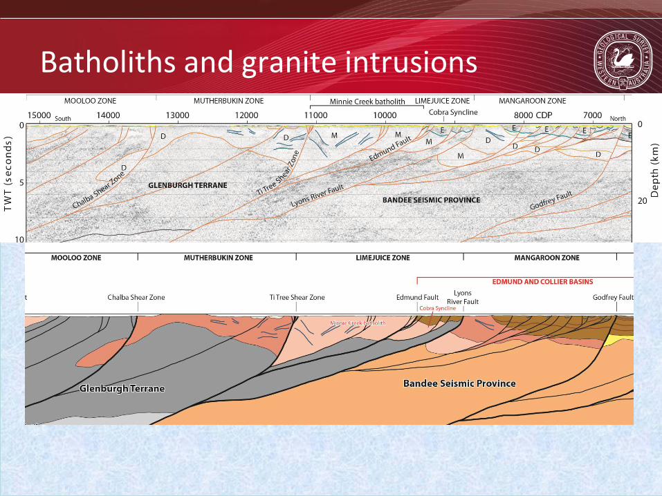
• Gascoyne Province-wide orogeny with granitic stocks and intrusions across the entire province • Metamorphism related thermal effects of granite magmas. Deformation includes compression, folding and faulting • However, voluminous magmatism was focussed within the Limejuice Zone producing the Minnie Creek batholith
• gabbro-monzogranite • S-type granites although oxygen isotopes of zircon indicate mantle derived component • Shape of batholith at depth?

Government of Western Australia Department of Mines and Petroleum Government of Western Australia Department of Mines and Petroleum Government of Western Australia Department of Mines and Petroleum
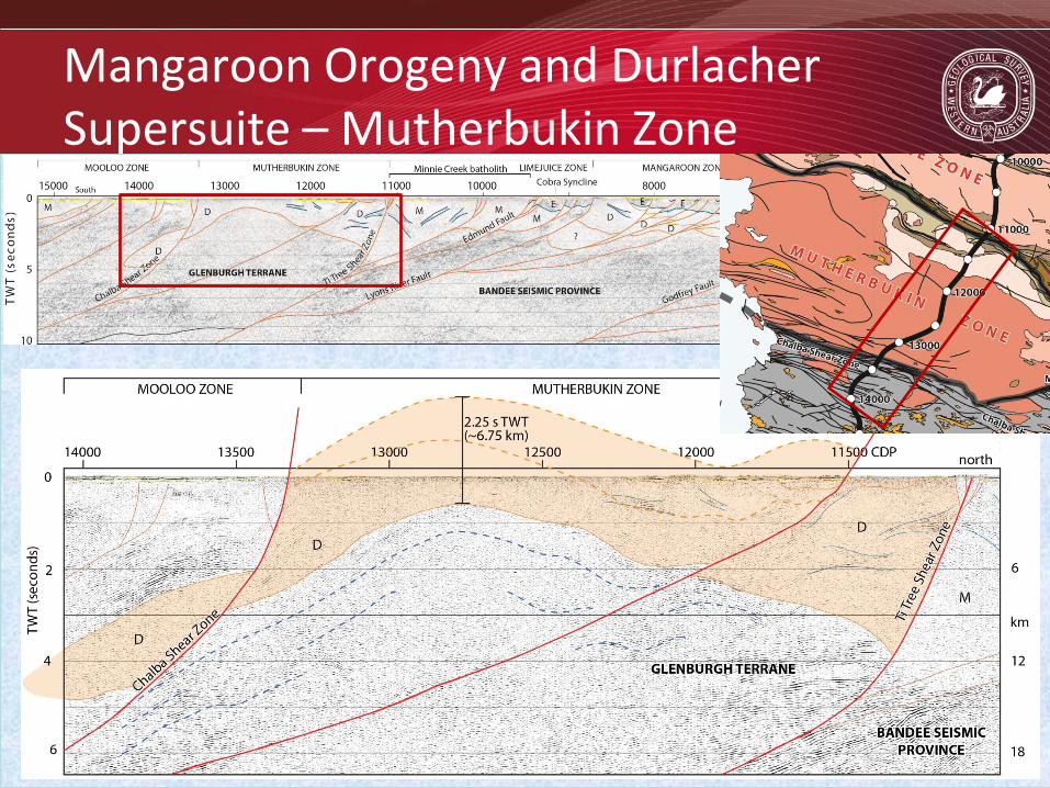
1680–1620 Ma Mangaroon Orogeny
• Punctuated magmatism - metamorphism and deformation restricted to Mangaroon Zone • High-T, granulite facies grade metamorphism at 1680–1675 Ma
• Contemporaneous sedimentation – granite magmatism – metamorphism • High geothermal gradients • thin crust, extensional deformation?
• 1660–1650 Ma granite magmatism in the Mutherbukin Zone •1620 Ma intrusion in the YGC • How are these events linked in the crust?
Government of Western Australia Department of Mines and Petroleum Government of Western Australia Department of Mines and Petroleum Government of Western Australia Department of Mines and Petroleum
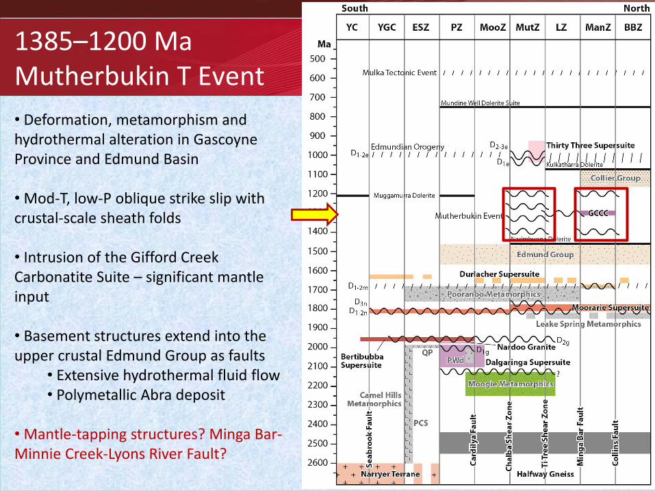
1385–1200 Ma Mutherbukin T Event
• Deformation, metamorphism and hydrothermal alteration in Gascoyne Province and Edmund Basin • Mod-T, low-P oblique strike slip with crustal-scale sheath folds • Intrusion of the Gifford Creek Carbonatite Suite – significant mantle input • Basement structures extend into the upper crustal Edmund Group as faults
• Extensive hydrothermal fluid flow • Polymetallic Abra deposit
• Mantle-tapping structures? Minga Bar-Minnie Creek-Lyons River Fault?

Government of Western Australia Department of Mines and Petroleum Government of Western Australia Department of Mines and Petroleum Government of Western Australia Department of Mines and Petroleum
1030–955 Ma
Edmundian Orogeny
• Deformation in both the Gascoyne Province and Edmund and Collier Basins • Mod-T, Mod-P metamorphism within a 10–20 km wide corridor along the Ti Tree Shear Zone.
• Leucocratic tourmaline-granites and REE-bearing pegmatites in the basement (Thirty Three Supersuite)
• Major period of open to tight folding, plus faulting in both the Edmund and Collier Basins • Crustal thickening with basement – cover detachment ?

Government of Western Australia Department of Mines and Petroleum Government of Western Australia Department of Mines and Petroleum Government of Western Australia Department of Mines and Petroleum
c. 570 Ma Mulka Tectonic Event
• Network of anastamosing shear zones and brittle-ductile faults • Dextral strike slip with offsets 10-100m
• Some faults may have large offsets up to 4km
• Concentrated into discrete corridors such as the Chalba Shear Zone (5–10 km wide) • Reactivation of older structures

Government of Western Australia Department of Mines and Petroleum Government of Western Australia Department of Mines and Petroleum Government of Western Australia Department of Mines and Petroleum
Preliminary interpretation of seismic lines 10GA–CP2 and 10GA–CP3
• Location and orientation of major terrane-bounding faults, including any potential suture zones • The depth and shape of the Minnie Creek batholith, and other Proterozoic granite intrusions • The deep crustal structure of the Edmund and Collier Basins • Better refine the crustal architecture of the Gascoyne Province

Government of Western Australia Department of Mines and Petroleum Government of Western Australia Department of Mines and Petroleum Government of Western Australia Department of Mines and Petroleum
Preliminary interpretation of seismic line 10GA–CP2
Government of Western Australia Department of Mines and Petroleum Government of Western Australia Department of Mines and Petroleum Government of Western Australia Department of Mines and Petroleum
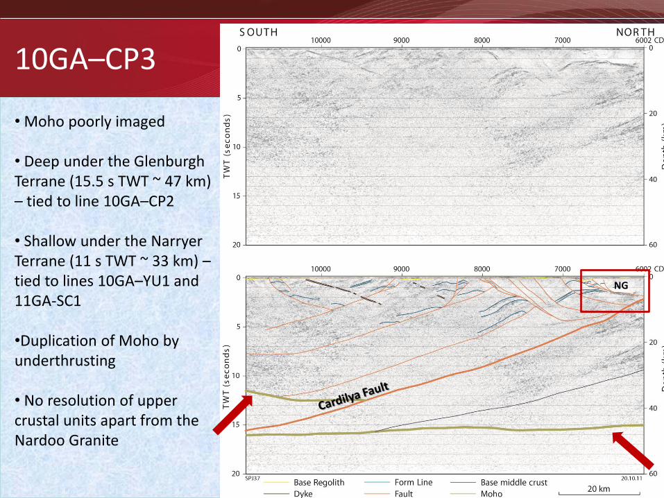
10GA–CP3
NG
• Moho poorly imaged • Deep under the Glenburgh Terrane (15.5 s TWT ~ 47 km) – tied to line 10GA–CP2 • Shallow under the Narryer Terrane (11 s TWT ~ 33 km) – tied to lines 10GA–YU1 and 11GA-SC1 •Duplication of Moho by underthrusting • No resolution of upper crustal units apart from the Nardoo Granite

Government of Western Australia Department of Mines and Petroleum Government of Western Australia Department of Mines and Petroleum Government of Western Australia Department of Mines and Petroleum
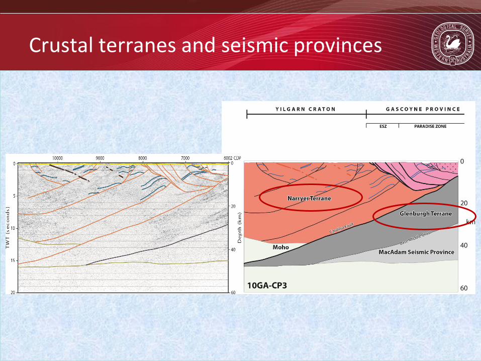
Crustal terranes and seismic provinces
Government of Western Australia Department of Mines and Petroleum Government of Western Australia Department of Mines and Petroleum Government of Western Australia Department of Mines and Petroleum
Crustal terranes and seismic provinces

Government of Western Australia Department of Mines and Petroleum Government of Western Australia Department of Mines and Petroleum Government of Western Australia Department of Mines and Petroleum
Suture zones revisited
Assembled during two distinct and separate events. Two collisions and two sutures • Collision/accretion of the Pilbara Craton with the oldest part of the Gascoyne Province (Glenburgh Terrane) during the 2215–2145 Ma Ophthalmian Orogeny • TALGA FAULT
• Collision of a combined Pilbara Craton – Glenburgh Terrane with the Yilgarn Craton during the 2005–1950 Ma Glenburgh Orogeny • ERRABIDDY SHEAR ZONE

Government of Western Australia Department of Mines and Petroleum Government of Western Australia Department of Mines and Petroleum Government of Western Australia Department of Mines and Petroleum
Pilbara Craton – Glenburgh Terrane suture
The Talga Fault
LWG LWG
UWG
10GA–CP2

Government of Western Australia Department of Mines and Petroleum Government of Western Australia Department of Mines and Petroleum Government of Western Australia Department of Mines and Petroleum
Pilbara Craton – Glenburgh Terrane suture
The Lyons River Fault
10GA–CP2

Government of Western Australia Department of Mines and Petroleum Government of Western Australia Department of Mines and Petroleum Government of Western Australia Department of Mines and Petroleum
Implications for the 2215–2145 Ma
Ophthalmian Orogeny • Original geodynamic model is potentially incorrect – southward-directed subduction • Reasonably assume some form of magmatic arc leading up to the collision • Not evident in the southern Pilbara • Need to be looking in the Glenburgh Terrane

Government of Western Australia Department of Mines and Petroleum Government of Western Australia Department of Mines and Petroleum Government of Western Australia Department of Mines and Petroleum
Glenburgh Terrane – Yilgarn Craton suture
The Errabiddy Shear Zone • Moderately north-dipping imbricate zone • Intersects the moderately south-dipping Cardilya Fault at 4 s TWT (~12 km)
• Cardilya Fault transects the entire crust, duplicating the Moho • Strong reflections in the GT indicate high strain zone

Government of Western Australia Department of Mines and Petroleum Government of Western Australia Department of Mines and Petroleum Government of Western Australia Department of Mines and Petroleum
Errabiddy Shear Zone and Cardilya Fault
• Errabiddy Shear Zone is the principal suture between the Glenburgh Terrane and the Yilgarn Craton • Cut by the Cardilya Fault • Both related to the collision during the Glenburgh Orogeny • Proto-Cardilya Fault may have formed in thinned crust in the back arc of the Dalgaringa Arc

Government of Western Australia Department of Mines and Petroleum Government of Western Australia Department of Mines and Petroleum Government of Western Australia Department of Mines and Petroleum
Suture Zones - conclusions
Lyons River Fault
Cardilya Fault
• Three crustal blocks and two suture zones • Lyons River Fault – Minga Bar Fault – Minnie Creek Fault represent the northern suture between the Pilbara Craton (Bandee SP) and the Glenburgh Terrane
• Although the Errabiddy Shear Zone IS the principal suture zone between the Glenburgh Terrane and Yilgarn Craton, the Cardilya Fault is the main crustal structure that separates the two
Government of Western Australia Department of Mines and Petroleum Government of Western Australia Department of Mines and Petroleum Government of Western Australia Department of Mines and Petroleum
Batholiths and granite intrusions

Government of Western Australia Department of Mines and Petroleum Government of Western Australia Department of Mines and Petroleum Government of Western Australia Department of Mines and Petroleum
Capricorn Orogeny and Moorarie Supersuite – Minnie Creek batholith
M

Government of Western Australia Department of Mines and Petroleum Government of Western Australia Department of Mines and Petroleum Government of Western Australia Department of Mines and Petroleum
Mangaroon Orogeny and Durlacher Supersuite – Mangaroon Zone
? ?
Government of Western Australia Department of Mines and Petroleum Government of Western Australia Department of Mines and Petroleum Government of Western Australia Department of Mines and Petroleum
Mangaroon Orogeny and Durlacher Supersuite – Mutherbukin Zone

Government of Western Australia Department of Mines and Petroleum Government of Western Australia Department of Mines and Petroleum Government of Western Australia Department of Mines and Petroleum
Glenburgh Orogeny and Dalgaringa Supersuite

Government of Western Australia Department of Mines and Petroleum Government of Western Australia Department of Mines and Petroleum Government of Western Australia Department of Mines and Petroleum
Fault reactivation and crustal reworking
• Gascoyne Province zone boundaries are all major crustal-scale faults or shear zones • Juxtapose rocks from different crustal levels • To accommodate deformation and metamorphism during punctuated crustal reworking, these faults must have been multiply reactivated

Government of Western Australia Department of Mines and Petroleum Government of Western Australia Department of Mines and Petroleum Government of Western Australia Department of Mines and Petroleum
Fault reactivation and crustal reworking
Talga Fault – Ophthalmian thrust (c. 2200 Ma), Edmund Basin extensional fault (c. 1450 Ma). Godfrey Fault – Edmund Basin extensional Fault (c. 1465 Ma), Mutherbukin thrust fault (c. 1200 Ma). Lyons River Fault – Ophthalmian suture zone (c. 2200 Ma), Mangaroon reactivation (c. 1680 Ma), Edmund Basin extensional Fault (c. 1465 Ma), Edmundian/Mutherbukin reactivation (c. 1200 or c. 1000 Ma).

Government of Western Australia Department of Mines and Petroleum Government of Western Australia Department of Mines and Petroleum Government of Western Australia Department of Mines and Petroleum
Crustal architecture
• All major faults and shear zones are principal crustal structures related to the assembly of the West Australian Craton during the Ophthalmian and Glenburgh Orogenies • Reactivation of these structures during over one billion years of repeated crustal reworking, has controlled the partitioning of tectonometamorphism, granite magmatism and sedimentation into discrete tectonic corridors • The present-day architecture and post 1950 Ma geological history of the Gascoyne Province has ultimately been influenced by events that took place some 2200 to 1950 million years ago

Government of Western Australia Department of Mines and Petroleum Government of Western Australia Department of Mines and Petroleum Government of Western Australia Department of Mines and Petroleum
Summary
• The seismic lines have added significant knowledge and understanding of the tectonic evolution of this part of the Capricorn Orogen • Determined the location and orientation of the major suture zones and crustal structures • Better understanding of the depth and shape of the Minnie Creek batholith and other Proterozoic intrusions • Overall, a much more precise understanding of the crustal architecture of the region