geology of the kajiado region, kenya - geological … faults-small! city! town! village rive s...
TRANSCRIPT
%% %% %% %% %% %% %% %% %% %% %% %% %% %% %% %% %% %% faults-large
faults-small
! City! Town! Village
rivers
200m-contour
Road-major
Road-minor
Road-track
rail
Above: Location of presented geologic map (grey-square) in relation to the major rift bounding faults and Lake Turkana
Geology of the Kajiado Region, Kenya
²0 10 20 305
Kilometers
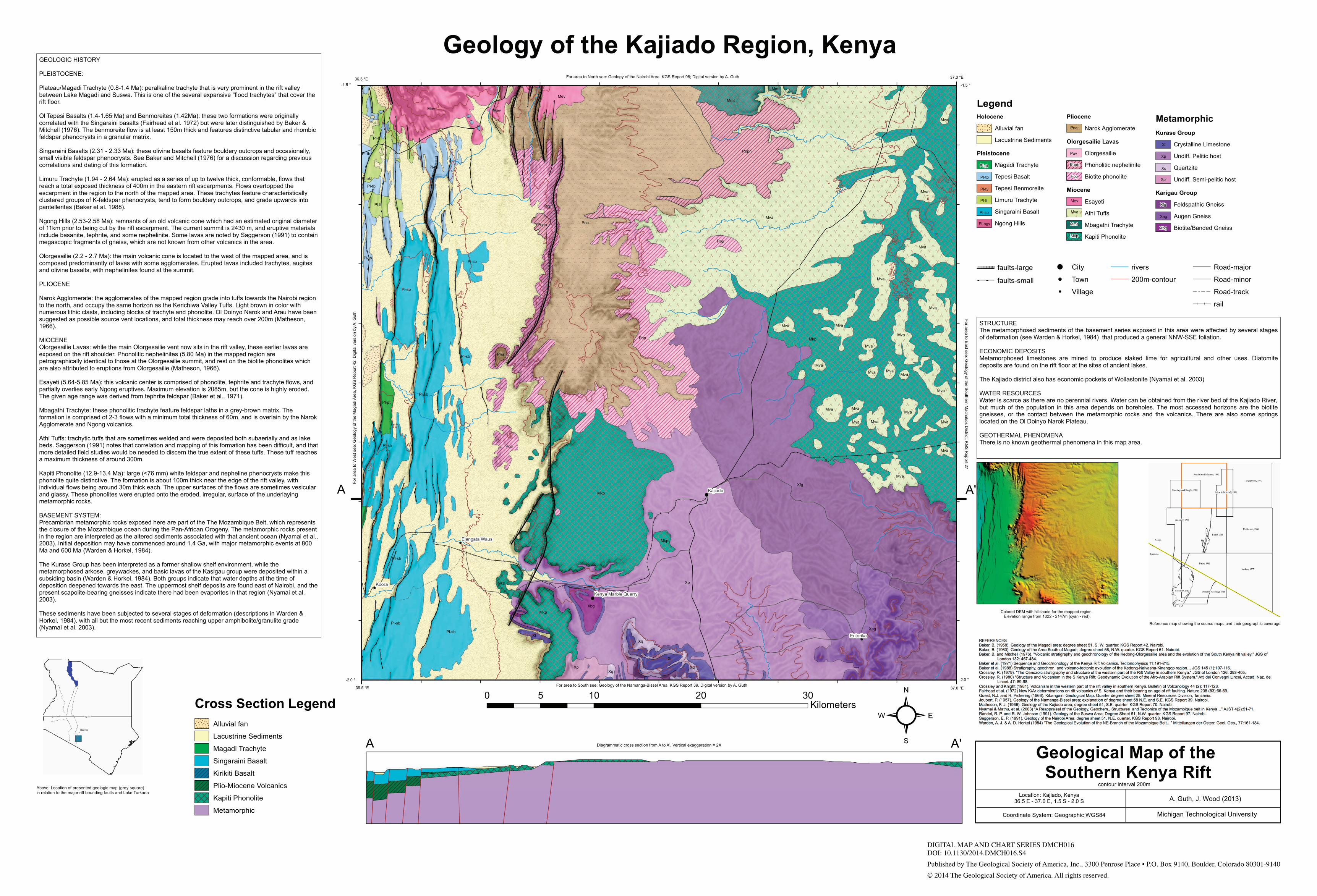
GEOLOGIC HISTORY
PLEISTOCENE:
Plateau/Magadi Trachyte (0.8-1.4 Ma): peralkaline trachyte that is very prominent in the rift valleybetween Lake Magadi and Suswa. This is one of the several expansive "flood trachytes" that cover therift floor.
Ol Tepesi Basalts (1.4-1.65 Ma) and Benmoreites (1.42Ma): these two formations were originallycorrelated with the Singaraini basalts (Fairhead et al. 1972) but were later distinguished by Baker &Mitchell (1976). The benmoreite flow is at least 150m thick and features distinctive tabular and rhombicfeldspar phenocrysts in a granular matrix.
Singaraini Basalts (2.31 - 2.33 Ma): these olivine basalts feature bouldery outcrops and occasionally,small visible feldspar phenocrysts. See Baker and Mitchell (1976) for a discussion regarding previouscorrelations and dating of this formation.
Limuru Trachyte (1.94 - 2.64 Ma): erupted as a series of up to twelve thick, conformable, flows thatreach a total exposed thickness of 400m in the eastern rift escarpments. Flows overtopped theescarpment in the region to the north of the mapped area. These trachytes feature characteristicallyclustered groups of K-feldspar phenocrysts, tend to form bouldery outcrops, and grade upwards intopantellerites (Baker et al. 1988).
Ngong Hills (2.53-2.58 Ma): remnants of an old volcanic cone which had an estimated original diameterof 11km prior to being cut by the rift escarpment. The current summit is 2430 m, and eruptive materialsinclude basanite, tephrite, and some nephelinite. Some lavas are noted by Saggerson (1991) to containmegascopic fragments of gneiss, which are not known from other volcanics in the area.
Olorgesailie (2.2 - 2.7 Ma): the main volcanic cone is located to the west of the mapped area, and iscomposed predominantly of lavas with some agglomerates. Erupted lavas included trachytes, augitesand olivine basalts, with nephelinites found at the summit.
PLIOCENE
Narok Agglomerate: the agglomerates of the mapped region grade into tuffs towards the Nairobi regionto the north, and occupy the same horizon as the Kerichiwa Valley Tuffs. Light brown in color withnumerous lithic clasts, including blocks of trachyte and phonolite. Ol Doinyo Narok and Arau have beensuggested as possible source vent locations, and total thickness may reach over 200m (Matheson,1966).
MIOCENEOlorgesailie Lavas: while the main Olorgesailie vent now sits in the rift valley, these earlier lavas areexposed on the rift shoulder. Phonolitic nephelinites (5.80 Ma) in the mapped region arepetrographically identical to those at the Olorgesailie summit, and rest on the biotite phonolites whichare also attributed to eruptions from Olorgesailie (Matheson, 1966).
Esayeti (5.64-5.85 Ma): this volcanic center is comprised of phonolite, tephrite and trachyte flows, andpartially overlies early Ngong eruptives. Maximum elevation is 2085m, but the cone is highly eroded.The given age range was derived from tephrite feldspar (Baker et al., 1971).
Mbagathi Trachyte: these phonolitic trachyte feature feldspar laths in a grey-brown matrix. Theformation is comprised of 2-3 flows with a minimum total thickness of 60m, and is overlain by the NarokAgglomerate and Ngong volcanics.
Athi Tuffs: trachytic tuffs that are sometimes welded and were deposited both subaerially and as lakebeds. Saggerson (1991) notes that correlation and mapping of this formation has been difficult, and thatmore detailed field studies would be needed to discern the true extent of these tuffs. These tuff reachesa maximum thickness of around 300m.
Kapiti Phonolite (12.9-13.4 Ma): large (<76 mm) white feldspar and nepheline phenocrysts make thisphonolite quite distinctive. The formation is about 100m thick near the edge of the rift valley, withindividual flows being around 30m thick each. The upper surfaces of the flows are sometimes vesicularand glassy. These phonolites were erupted onto the eroded, irregular, surface of the underlayingmetamorphic rocks.
BASEMENT SYSTEM:Precambrian metamorphic rocks exposed here are part of the The Mozambique Belt, which representsthe closure of the Mozambique ocean during the Pan-African Orogeny. The metamorphic rocks presentin the region are interpreted as the altered sediments associated with that ancient ocean (Nyamai et al.,2003). Initial deposition may have commenced around 1.4 Ga, with major metamorphic events at 800Ma and 600 Ma (Warden & Horkel, 1984).
The Kurase Group has been interpreted as a former shallow shelf environment, while themetamorphosed arkose, greywackes, and basic lavas of the Kasigau group were deposited within asubsiding basin (Warden & Horkel, 1984). Both groups indicate that water depths at the time ofdeposition deepened towards the east. The uppermost shelf deposits are found east of Nairobi, and thepresent scapolite-bearing gneisses indicate there had been evaporites in that region (Nyamai et al.2003).
These sediments have been subjected to several stages of deformation (descriptions in Warden &Horkel, 1984), with all but the most recent sediments reaching upper amphibolite/granulite grade(Nyamai et al. 2003).
STRUCTUREThe metamorphosed sediments of the basement series exposed in this area were affected by several stagesof deformation (see Warden & Horkel, 1984) that produced a general NNW-SSE foliation.
ECONOMIC DEPOSITSMetamorphosed limestones are mined to produce slaked lime for agricultural and other uses. Diatomitedeposits are found on the rift floor at the sites of ancient lakes.
The Kajiado district also has economic pockets of Wollastonite (Nyamai et al. 2003)
WATER RESOURCESWater is scarce as there are no perennial rivers. Water can be obtained from the river bed of the Kajiado River,but much of the population in this area depends on boreholes. The most accessed horizons are the biotitegneisses, or the contact between the metamorphic rocks and the volcanics. There are also some springslocated on the Ol Doinyo Narok Plateau.
GEOTHERMAL PHENOMENAThere is no known geothermal phenomena in this map area.
For area to North see: Geology of the Nairobi Area, KGS Report 98; Digital version by A. Guth
Geological Map of the Southern Kenya Rift
A. Guth, J. Wood (2013)Location: Kajiado, Kenya36.5 E - 37.0 E, 1.5 S - 2.0 S
Coordinate System: Geographic WGS84 Michigan Technological University
contour interval 200m
!
!
!
!
!
%% %% %% %% %% %% %%%% %% %%%%%%%%%%%%%%%%%%%%%%%%%%%%%%%%%%%%%%%%%%%%%%%%%%%%%%%%%%%%%%%% %%%%%%%% %%%%%%%% %% %%%% %% %% %% %% %%%%%% %% %% %% %% %%%%%% %% %%%%%%%%%%%%%%%%%%%%%%%%%%%%%%%%%%%%%%%%%%%%%%%%%%%%%%%%%%%%%%%%
%%%%%%%%%%%%%%%%%%%%%%%%%%%%%%%%%%%%%%%%%%%%%%%% %% %% %% %% %%%% %% %%%%%%%%%%%%%%%%%%%%%%%%%%%%%%%% %% %% %%%% %% %% %% %% %% %% %%%% %% %% %% %% %% %% %%%% %% %% %% %% %% %% %%%% %% %% %% %% %% %% %%%% %% %% %% %% %% %%%% %%
%% %% %% %% %% %% %% %% %% %%%% %% %% %% %% %% %% %% %%%% %% %% %% %% %% %% %% %%%% %% %% %% %% %% %% %% %%%% %% %% %% %% %% %% %% %%%% %% %% %% %% %% %%%% %% %% %% %% %% %% %%%% %% %% %% %% %% %% %%%% %% %% %% %% %% %% %%%% %% %% %% %% %% %%%% %% %% %% %%%% %%%% %% %%%% %% %% %%%%%% %% %%%%%%%%%% %%%%%%%% %%%%%%%%%% %%%%%%%% %%%% %% %% %% %% %% %% %%%% %% %% %% %% %% %% %%%% %% %% %% %% %% %%%% %% %%%%%%%%%%%%%%%%%%%%%%%%%%%%%%%%%%%%%%%%%%%%%%%%%%%%%%%% %% %%%% %% %%%%%% %% %%%% %% %% %% %%%% %% %% %% %% %% %% %%%% %% %% %% %% %% %%%% %% %% %% %% %% %%%% %%%% %% %% %% %%%% %% %% %% %% %% %%%% %% %% %% %% %% %%%% %% %% %% %% %%
%%%%%%%%%%%%%%%%%%%%%%%%%%%%%%%%%%%%%%%%%%%%%%%%%%%%%%%%%%%%%%%%%%%%%%%%%%%%%%%%%%%% %% %% %%%% %% %% %% %% %% %%%% %% %% %% %% %% %% %%%% %% %% %% %% %% %% %%%% %%%% %%%% %%%%%%%% %% %%%% %%%%%% %% %% %% %% %% %% %%%% %% %% %% %% %% %%%% %%%% %% %%
%%%%%%%%%%%%%%%%%%%% %% %%%% %% %% %%%% %% %%%%%%%%%%%%%%%%%%%%%%%%%%%%%%%%%%%%%%%%%%%%%%%%%%%%%% %% %%%% %% %% %% %% %% %% %%%% %% %% %% %% %% %% %%%% %% %% %% %% %% %% %%%% %% %% %% %% %%%%%% %% %% %% %% %% %%%% %% %% %% %% %% %% %%%% %% %% %% %% %% %% %%%% %%%% %% %% %% %%%% %% %%
%%%%%%%%%%%%%%%%%%%%%%%%%%%%%%%%%%%%%%%%%%%%%%%%%%%%%%%%%%%%%%%%%%%%%%%%%%%%%%%%%%%%%%%%%%%%%%%%%%%%%%%%%%%%%%%%%%%%%%%%%%%%%%%%%%%%%%%%%%%%%%%%%%%%%%%%%%%%%%%%%%%%%%%%%%%%%%%%%%%%%%%%%%%%%%%%%%%%%%%%%%%%%%%%%%%%%%%%%%%%%%%%%%%%%%%%%%%%%%%%%%%%%%%%%%%%
%% %% %% %% %% %% %% %%%% %% %% %% %% %% %% %%%% %% %% %% %% %% %% %%%% %% %% %% %% %% %% %%%% %% %% %% %% %% %% %%%% %% %% %% %% %% %% %%%% %% %% %% %% %% %% %%%% %% %% %% %% %% %% %%%% %% %% %% %% %% %% %%%% %% %% %% %% %% %% %%%% %% %% %% %% %% %% %%%% %%%%%%%%%%%%%%%%%%%%%% %% %% %% %%%% %% %% %% %% %% %% %%%% %% %% %% %% %% %%%% %% %% %% %% %% %%%% %% %%%%%%%%%%%%%%%%%%%%%%%%%%%%%%%%%%%%%%%%%%%%%%%%%%%%%%%%%%%%%%%%%% %%%% %% %% %% %% %% %%%% %% %% %% %% %% %%%% %% %% %% %% %% %%%% %% %% %% %% %% %%%% %% %% %% %% %% %%%%%%%%%%%%%%%%%%%%%%%%%%%%%%%%%%%%%%%%%%%%%%%%%%%% %% %% %% %%%% %% %% %% %% %% %% %%%% %% %% %% %% %% %%%% %% %% %% %% %% %% %%%% %% %% %% %% %% %% %%%% %% %% %% %% %% %% %%
%% %% %% %% %% %% %% %% %%%% %% %% %% %% %% %% %%%% %% %% %% %% %% %% %%%% %% %% %% %% %% %% %%%% %% %% %% %% %% %% %%%% %% %% %% %% %% %% %%%% %% %% %% %% %% %% %% %%%% %%
Xp
Xfg
Xag
Xl
Xq
Xp'
Xbg
Xq
Xl
Xp
Xq
Mkp
PnaMva
Mkp
Pop
Pl-sb
Pop
Popn
Mev
Pl-sb
Mkp
Pl-sb
Pl-sb
Pl-sb
Mva
Mmt
Pl-lt
Pl-tb
Mva
Mva
Mva
Mev
Mva
Mva
Pop
Pl-sb
Mva
Pl-pt
Pl-sb
Mva
Pl-tb
Mva
Pl-lt
Mkp
Pop
Mva
Mva
Mev
Mva
Mkp
Popn
Mva
Pl-tb
Pl-tb
Mva
Pna
Mva
Mva
Mva
Pl-sb
Mva
Mva
Mva
Mva
Mmt
Mva
Pl-okl
1400
1600
1200
1800
2000
1600
1600
1800
2000
1600
1600
1600
1800
2000
1800
1200
16001800
1800
1600
1600
1800
1400
1800
2000
2000
1800
2000
2000
2000
1600
2000
1600
1600
1800
1600
2000
Koora
Kajiado
Entorika
Elangata Waus
Kenya Marble Quarry
A'A
For area to South see: Geology of the Namanga-Bissel Area, KGS Report 39. Digital version by A. Guth
For area to East see: G
eology of the Southern M
achakos District, K
GS
Report 27
For a
rea
to W
est s
ee: G
eolo
gy o
f the
Mag
adi A
rea,
KG
S R
epor
t 42;
Dig
ital v
ersi
on b
y A
. Gut
h
Diagrammatic cross section from A to A'. Vertical exaggeration = 2X
Colored DEM with hillshade for the mapped region. Elevation range from 1022 - 2147m (cyan - red).
Reference map showing the source maps and their geographic coverage
36.5 °E 37.0 °E
37.0 °E36.5 °E
-2.0 ° -2.0 °
-1.5 °-1.5 °
Cross Section LegendAlluvial fan
Lacustrine Sediments
Magadi Trachyte
Singaraini Basalt
Kirikiti Basalt
Plio-Miocene Volcanics
DDDDDDDDDDDDDDD
Kapiti Phonolite
Metamorphic
LegendHolocene
Alluvial fan
Lacustrine Sediments
Pleistocene
Magadi Trachyte
Tepesi Basalt
Tepesi Benmoreite
Limuru Trachyte
Singaraini Basalt
Ngong Hills
Pliocene
Narok Agglomerate
Olorgesailie Lavas
Olorgesailie
Phonolitic nephelinite
Biotite phonolite
Miocene
Esayeti
Athi Tuffs
DDDDDDDDDDDDDDD
Mbagathi Trachyte
DDDDDDDDDDDDDDDKapiti Phonolite
MetamorphicKurase Group
Crystalline Limestone
Undiff. Pelitic host
Quartzite
Undiff. Semi-pelitic host
Karigau Group
Feldspathic Gneiss
Augen Gneiss
Biotite/Banded Gneiss
Mva
Mkp
Mev
Mmt
Pop
Pl-lt
Pl-ngv
Pl-tv
Xp
Pl-tb
Pl-pt
Pna
Pl-sb
Xbg
Xl
Xfg
Xq
Xag
Popn
A'A
Xp'
Pov
DIGITAL MAP AND CHART SERIES DMCH016DOI: 10.1130/2014.DMCH016.S4
Published by The Geological Society of America, Inc., 3300 Penrose Place • P.O. Box 9140, Boulder, Colorado 80301-9140
© 2014 The Geological Society of America. All rights reserved.