geomorphology and surface materials: barr creek to
TRANSCRIPT

GEOMORPHOLOGY AND SURFACE MATERIALS: BARR CREEK TO GUNBOWER ISLAND
J.D.A. Clarke, V. Wong, C. P. Pain, H. Apps, D. Gibson, J. Luckman and K. Lawrie
CRC LEME Open File Report 250
December 2008
© CRC LEME 2008
CRC LEME is an unincorporated joint venture between the Australian National University, University of Canberra, Australian Geological Survey Organisation and CSIRO Exploration and Mining.
Headquarters:- CRC LEME C/o CSIRO Exploration and Mining, Private Bag 5, Wembley 6913, Western Australia.

ii
Address and affiliation of authors
J.D.A. Clarke, V. Wong, C. Pain, H. Apps, D. Gibson, J. Luckman and K. Lawrie Cooperative Research Centre for Landscape Evolution and Mineral Exploration c/- Geoscience Australia PO Box 378 Canberra ACT 2601
DISCLAIMER
The user accepts all risks and responsibility for losses, damages, costs and other consequences resulting directly or indirectly from using any information or material contained in this report. To the maximum permitted by law, CRC LEME excludes all liability to any person arising directly or indirectly from using any information or material contained in this report.
© Cooperative Research Centre for Landscape Evolution and Mineral Exploration
2008

iii
EXECUTIVE SUMMARY
Over the past 15 years more than 40 airborne electromagnetic (AEM) surveys have been acquired for groundwater and salinity mapping and natural resource management in Australia. Most of these have been in floodplain or other low relief landscapes. Several projects have successfully demonstrated how AEM surveys can be used to underpin a wide range of salinity management strategies, and a review of salinity mapping methods in the Australian context by Spies and Woodgate in 2004 recommended that AEM systems were the most appropriate for mapping salinity in Australia’s landscapes.
In early 2007, an airborne electromagnetic (AEM) survey was acquired along a 450 km reach of the River Murray Corridor (RMC) in SE Australia. This aim of this survey, carried out under the auspices of the Australian Government’s Community Stream Sampling and Salinity Mapping Project (CSSSMP), and managed by the Bureau of Rural Sciences (BRS), is to provide information vital for addressing salinity, land management and groundwater resource issues. The study area stretches from the South Australian border eastwards to Gunbower in Victoria. A total of 24,000 line km of AEM data were acquired. The survey area encompasses iconic wetland areas, national and state forest parks, and areas of irrigation and dryland farming.
Within the RMC project area key land management questions include (1) what is the impact of irrigation on the floodplain, river and groundwater system?; (2) what is the distribution of saline groundwaters where these have the potential to impact on the floodplain and river?; (3) where are the salt stores in the unsaturated zone within the floodplain?; (4) what is the potential for salt mobilisation during Living Murray inundation actions and natural flood events; (5) what are the drivers for floodplain health with respect to groundwater processes?; (6) is there leakage from salt disposal infrastructure?; and (7) what is the extent of losing and gaining effects along different reaches of the river system?
To address many of these questions, maps of the distribution of salt stores, saline and fresh groundwater and the hydraulic properties of soil and regolith materials in the shallow sub-surface are required. These are required to provide a 3-D understanding of how salt stores and saline groundwaters connect to the surface waterways and land surface. Sub-surface interpretations in the survey areas are hampered by a low density of useful borehole data in the floodplain in particular, and by a paucity of soil and landscape surface mapping at appropriate scales throughout the project area. New maps of surface materials, and a new geomorphic understanding of the RMC project area is required to constrain the interpretation of the AEM surveys, and address the land management questions.
This report documents the results of new surface materials mapping in the Barr Creek to Gunbower Island survey area, and the methodology used to produce the maps.
The floodplain associated with the Murray River consists of two different morphologies, a distinctive channelled wetland morphology, very clay rich, with numerous small channels separated by mounds, and a indurated clay-rich smooth floodplain. The river channels are of two types, a fixed channel with distinct silt levees, and a leveed meander channel where the channels have undergone limited migration with scroll bar formation and are raised above the level of the floodplain. The scroll bar surfaces are of clay-draped sand. The Murray River is characterised by both types, Gunbower Creek just by the leveed meanders. The southern end of the floodplain is marked by the encroachment of the Loddon Fan and its associated distributaries.
Ken Lawrie Project Leader

iv
ABBREVIATIONS
ACRES Australian Centre for Remote Sensing AEM Airborne Electro Magnetics ASTER Advanced Spaceborne Thermal Emission and Reflection Radiometer BC Blanchetown Clay BRS Bureau of Rural Sciences CF Coonambidgal Formation CMA Catchment Management Authority CRC LEME Cooperative Research Centre for Landscape Environments and
Mineral Exploration DEM Digital elevation model EC Electrical conductivity GA Geoscience Australia LIDAR Light Detection and Ranging MDBC Murray-Darling Basin Commission MS Monoman Sands PS Parilla Sands RGB Red, Green, Blue RMC River Murray Corridor RMT River Murray Trench SF Shepparton Formation SPOT Satellite Pour l'Observation de la Terre STRM Shuttle Radar Terrain Model VNIR Very near infrared radiation WF Woorinen Formation XRF X-Ray Fluorescence XRD X-Ray Diffraction
v
CONTENTS
1 INTRODUCTION ............................................................................................................ 1 2 PREVIOUS STUDIES ..................................................................................................... 1 3 LAND MANAGEMENT QUESTIONS .......................................................................... 2 4 METHODOLOGY ........................................................................................................... 3
4.1 Data Availability and Quality .................................................................................. 3 4.1.1 Satellite imagery .................................................................................................. 3 4.1.2 Digital Elevation Models ..................................................................................... 3 4.1.3 Gamma-ray data................................................................................................... 4
4.2 Image Processing ..................................................................................................... 4 4.3 Field work ................................................................................................................ 5
5 RESULTS......................................................................................................................... 5 5.1 Regolith Landform Units.......................................................................................... 5
5.1.1 Floodplains .......................................................................................................... 5 5.1.2 Channels .............................................................................................................. 7 5.1.3 Lakes and pans..................................................................................................... 8 5.1.4 Dunes ................................................................................................................... 9
5.2 Vegetation ................................................................................................................ 9 5.2.1 Floodplains .......................................................................................................... 9 5.2.2 Channels ............................................................................................................ 11 5.2.3 Lakes and pans................................................................................................... 11 5.2.4 Dunes ................................................................................................................. 11
6 ANALYTIC RESULTS.................................................................................................. 12 6.1 Granulometry ......................................................................................................... 12 6.2 EC and pH.............................................................................................................. 13 6.3 XRF geochemistry ................................................................................................. 15 6.4 XRD mineralogy .................................................................................................... 16
7 IMPLICATIONS ............................................................................................................ 17 7.1 AEM modelling...................................................................................................... 17 7.2 Hydrogeological issues .......................................................................................... 17
7.2.1 Flow ................................................................................................................... 17 7.2.2 Recharge ............................................................................................................ 18
7.3 Relevance to land management questions.............................................................. 18 REFERENCES........................................................................................................................ 20 APPENDIX 1: ASTER data and interpretation....................................................................... 22 APPENDIX 2: SPOT data and interpretation.......................................................................... 24 APPENDIX 3: DEM data and interpretation .......................................................................... 26 APPENDIX 4: Gamma-ray data ............................................................................................. 28 APPENDIX 5. Surface materials ............................................................................................ 29 APPENDIX 5: Site Descriptions............................................................................................. 30 APPENDIX 6: Analytical Results............................................................................................. 1

vi
LIST OF FIGURES
Figure 1. Barr Creek-Gunbower study area............................................................................... 1
Figure 2. Hydrogeological model for Barr Creek-Gunbower Island showing AEM targets. Dark grey boxes define targets that have very high conductivities, white areas have moderate-high conductivities, and light grey boxes identify target areas with low conductivities. CF = Coonambidgal Formation, SF = Shepparton Formation. ................. 3
Figure 3. DEM coverage of the study area. ............................................................................... 4
Figure 4. Smooth floodplain of the northwestern Barr Creek-Gunbower area in LIDAR DEM showing relict lunettes of buried saline lakes. ................................................................... 6
Figure 5. LIDAR DEM of northern part of Barr-Creek-Gunbower area, showing smooth floodplain, infilled former lakes, and well developed levees along Murray River. .......... 6
Figure 6. LIDAR DEM of Floodplain morphologies at Gunbower island. Leveed meander belt of Gunbower Creek with pachydermal texture of channelled wet land between it and the course of the Murray River (top)....................................................................................... 7
Figure 7. Floodplain morphologies at Gunbower island. Leveed fix channel of Murray River (top) contrasts with leveed meander belt of Gunbower Creek (bottom). Distinctive pachydermal texture of channelled wetlands (usually dry at present) between the two streams is evident. ............................................................................................................. 8
Figure 8. Floodplain morphologies at Gunbower island. Leveed meander belt of Gunbower Creek with smooth floodplain on either side..................................................................... 9
Figure 9. Landform and surficial materials features of the Barr Creek-Gunbower region. Top left: active bend in Murray River opposite Gunbower Island showing a depositional bar forming on the inside of the bend. Top right: inactive bend in the Murray River opposite Gunbower Island showing the absence of depositional bars forming on the inside of bends and similar slopes on both the inside and outsides of beds. Middle left: Salts (gypsum and halite) crystallising in the capillary fringe of the floodplain water table next to the river. Middle right: dry channel in the floodplain channelled wetland. Bottom left: cleared smooth floodplain. Bottom right: uncleared channelled wetland floodplain. ..... 10
Figure 10. Location of soil site pits in the Barr Creek-Gunbower study area. ....................... 12
Figure 11. Sand and clay percentage from each geomorphic unit........................................... 13
Figure 12. Mean pH profiles from each geomorphic unit. Note: horizontal bars indicate the standard error of the mean. .............................................................................................. 15

vii
LIST OF TABLES
Table 1. Associations between regolith landform units, vegetation and surface materials in the Barr Creek-Gunbower reach of the river. ........................................................................ 11
Table 2. Comparison between grainsize and geomorphic unit................................................ 13
Table 3. Range of EC and pH values for different geomorphic units in the Barr Creek-Gunbower study area. ...................................................................................................... 14
Table 4. Mean values of selected XRF analyses. .................................................................... 16
1
1 INTRODUCTION
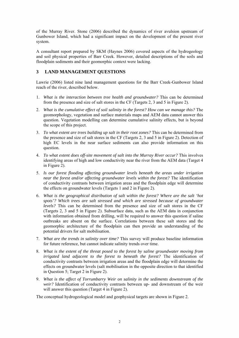
This is the final report in a series of studies along the Murray River between the South Australian border and the southern end of Gunbower Island (Figure 1). Earlier reports (see list on page v) describe the results of geomorphic and surface materials mapping using high resolution airborne LIDAR, ASTER, and SPOT data with input from LANDSAT and airborne gamma-ray data. Polygons were validated by field checking and surface properties of the soils were measured in by soil pits. The study was carried out in response to the land management questions identified by BRS and the community as part of the River Murray Corridor (RMC) project.
Figure 1. Barr Creek-Gunbower study area
2 PREVIOUS STUDIES
There have been few specific studies of the surface materials and geomorphology in this area. Churchward (1961, 1963a, b, c) reported on a number of soil studies across a broad region that included Gunbower Island and Barr Creek, but focussed predominantly on the NSW side
2
of the Murray River. Stone (2006) described the dynamics of river avulsion upstream of Gunbower Island, which had a significant impact on the development of the present river system.
A consultant report prepared by SKM (Haynes 2006) covered aspects of the hydrogeology and soil physical properties of Barr Creek. However, detailed descriptions of the soils and floodplain sediments and their geomorphic context were lacking.
3 LAND MANAGEMENT QUESTIONS
Lawrie (2006) listed nine land management questions for the Barr Creek-Gunbower Island reach of the river, described below.
1. What is the interaction between tree health and groundwater? This can be determined from the presence and size of salt stores in the CF (Targets 2, 3 and 5 in Figure 2).
2. What is the cumulative effect of soil salinity in the forest? How can we manage this? The geomorphology, vegetation and surface materials maps and AEM data cannot answer this question. Vegetation modelling can determine cumulative salinity effects, but is beyond the scope of this project.
3. To what extent are trees building up salt in their root zones? This can be determined from the presence and size of salt stores in the CF (Targets 2, 3 and 5 in Figure 2). Detection of high EC levels in the near surface sediments can also provide information on this question.
4. To what extent does off-site movement of salt into the Murray River occur? This involves identifying areas of high and low conductivity near the river from the AEM data (Target 4 in Figure 2).
5. Is our forest flooding affecting groundwater levels beneath the areas under irrigation near the forest and/or affecting groundwater levels within the forest? The identification of conductivity contrasts between irrigation areas and the floodplain edge will determine the effects on groundwater levels (Targets 1 and 2 in Figure 2).
6. What is the geographical distribution of salt within the forest? Where are the salt ‘hot spots’? Which trees are salt stressed and which are stressed because of groundwater levels? This can be determined from the presence and size of salt stores in the CF (Targets 2, 3 and 5 in Figure 2). Subsurface data, such as the AEM data in conjunction with information obtained from drilling, will be required to answer this question if saline outbreaks are absent on the surface. Correlations between these salt stores and the geomorphic architecture of the floodplain can then provide an understanding of the potential drivers for salt mobilisation.
7. What are the trends in salinity over time? This survey will produce baseline information for future reference, but cannot indicate salinity trends over time.
8. What is the extent of the threat posed to the forest by saline groundwater moving from irrigated land adjacent to the forest to beneath the forest? The identification of conductivity contrasts between irrigation areas and the floodplain edge will determine the effects on groundwater levels (salt mobilisation in the opposite direction to that identified in Question 5; Target 2 in Figure 2).
9. What is the affect of Torrumbarry Weir on salinity in the sediments downstream of the weir? Identification of conductivity contrasts between up- and downstream of the weir will answer this question (Target 4 in Figure 2).
The conceptual hydrogeological model and geophysical targets are shown in Figure 2.

3
CF
SF
Gunbower IslandIrrigation
1a
3
5
3 SF
2 6
4b4a
1b
Figure 2. Hydrogeological model for Barr Creek-Gunbower Island showing AEM targets. Dark grey boxes define targets that have very high conductivities, white areas have moderate-high conductivities, and light grey boxes identify target areas with low conductivities. CF = Coonambidgal Formation, SF = Shepparton Formation.
It is worth noting that the schematic diagram in Figure 2 contains a number of misleading elements. Firstly, the “trench” does not appear to exist in any obvious way in this region, instead the older depositional surfaces of the Shepparton Formation occur next to modern depositional surfaces of the Murray floodplain. Secondly, it is not known at this stage whether the Coonambidgal Formation is in fact underlain by the Shepparton, of on some older fluvial sediments. This is an issue to be clarified by drilling at a later time.
4 METHODOLOGY
4.1 Data Availability and Quality
4.1.1 Satellite imagery
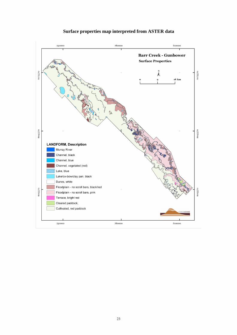
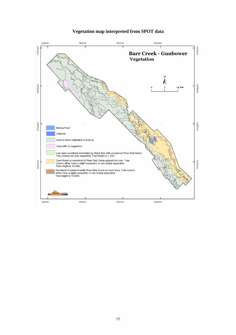
The primary satellite images used to compile surface polygons were those from ASTER and SPOT. Landsat images were used for comparison and infill, but were not normally interpreted as SPOT and ASTER coverage was generally adequate for the project area. ASTER images were used to map total surface variability (including soil mineralogy, moisture and vegetation; Appendix 1), while SPOT images were used to compile vegetation maps (Appendix 2).
Two ASTER scenes with 15m resolution covered the Barr Creek-Gunbower area. These scenes, the only ones available, were acquired from ACRES in GA and dated 05 March 2001 and 28 November 2002. The ASTER scenes were displayed as composite RGB images using the visible and near infrared radiation (VNIR) bands 3, 2 and 1. Four pan-sharpened pseudo natural colour SPOT scenes with 2.5 m resolution dated 15 December 2004, two dated 20 December 2004, and one on the 25 December 2004, were also acquired from GA. Bands 3, 2 and 1 were displayed in a composite RGB image. Two Landsat-7 ETM ortho-corrected images with 30 m resolution were acquired on the 04 February 2002 and 23 August 2002.
4.1.2 Digital Elevation Models
High resolution airborne LIDAR digital elevation model (DEM) coverage was available for part of the area (Figure 3). The LIDAR data were supplied by MDBC in ArcGRID format with 283 2 km x 2 km tiles at 1 m resolution within the Barr Creek-Gunbower area. The tiles were mosaicked together in ArcInfo and resampled to 2 m to minimise file size.
The Shuttle Radar Terrain Model (SRTM) was used as the base where other DEM data were not available. The SRTM was used as supplementary data only, as the spatial and vertical resolution are too low and the noise level too high at a scale of 1:25 000. Coverages are shown in Figure 3.

4
Figure 3. DEM coverage of the study area.
The LIDAR DEM was interpreted where it was available. The lower resolution DEMs, supported by ASTER and radiometric data, were used to extrapolate the distribution of units defined on the LIDAR DEM, guided by experience gained elsewhere in the River Murray Gorge (RMG). The final compilation is shown in Appendix 3.
4.1.3 Gamma-ray data
The gamma-ray data is shown in Appendix 4.
4.2 Image Processing
The ASTER level 1B scenes were supplied by ACRES in .hdf format, corrected for crosstalk, caused by signal leakage from band 4 into adjacent bands 5 and 9, and imported into ERMapper. Importing was carried out in three steps with bands of similar resolution ie. VNIR bands 1-3 at 1 5m resolution, SWIR (shortwave infrared radiation) bands 5 – 9 at 30 m resolution and TIR (thermal infrared radiation) bands 10 – 14 at 90 m resolution. All bands were rotated and corrected for dark pixels and radiance calibration, which included rescaling

5
of digital values to observed top of atmosphere radiance values. The resultant ERMapper datasets were displayed as composite RGB images.
SPOT 5 images were processed by Geoimage Pty Ltd for NSW Department of Infrastructure Planning and Natural Resources and supplied by GA. Processed LANDSAT 7 data was supplied following ACRES Quality Assessment.
The ASTER, SPOT and LIDAR images were printed at a scale of 1:25,000 and interpreted by mapping unit boundaries onto a registered stable transparent overlay with mapping pens. The interpreted line work was digitally scanned and the polygons attributed. The finished images were then printed out for verification.
4.3 Field work
A one day reconnaissance field trip was undertaken in May followed by six days of field work in June 2007. Mapped units were validated by field inspection and samples were collected from soil pits to determine the nature of the materials in the mapped geomorphic units. Field validation showed that 100% of the mapped units were correctly interpreted during mapping.
Twenty five soil pits were dug, all located on road reserves or adjacent to public access tracks. Shallow pits 30 cm deep were dug adjacent to roads in the Barr Creek-Gunbower region and sampled at 0-10, 10-20, 20-30 cm intervals. These pits provided information of the near-surface stratigraphy and characteristics of the regolith materials and also provided information on the soil structure of the site. These samples will be analysed for mineralogy using X-Ray Diffraction (XRD), for grain size using laser granulometry, and for chemistry using X-Ray Fluorescence (XRF). The site and the pits were photo-documented and the soil profiles and samples described in the field. The holes were filled in on completion. Field descriptions are shown in Appendix 6.
5 RESULTS
Mapping and field validation results are divided into two categories, regolith landform units and vegetation. The regolith landform units are the result of the landform and surface materials studies, while the vegetation units are determined from satellite imagery interpretation and site descriptions.
5.1 Regolith Landform Units
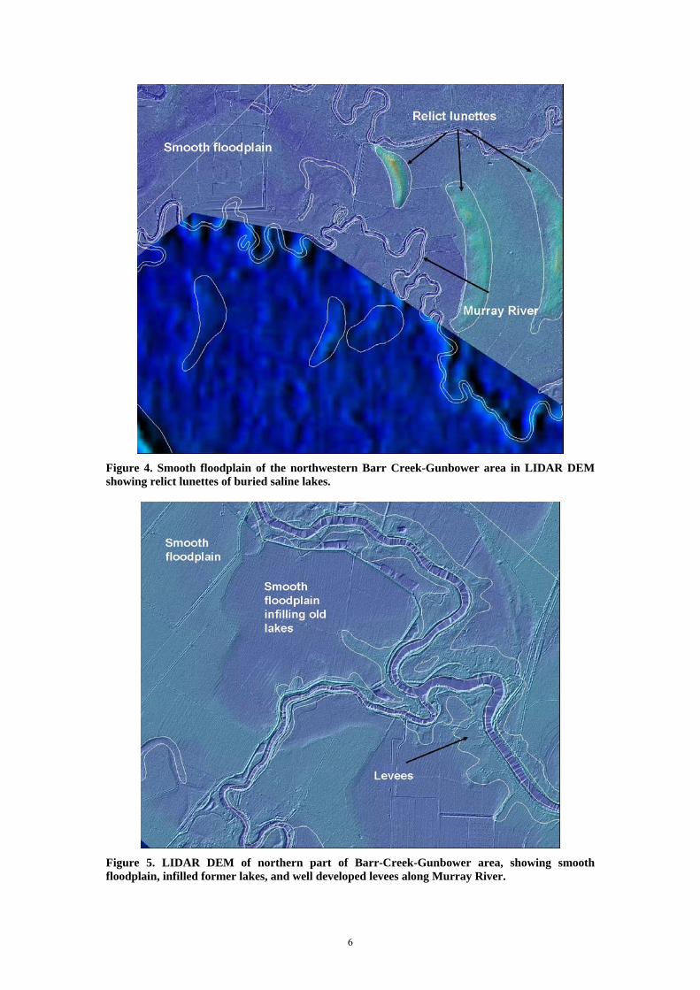
The north eastern half of the study area is similar to areas mapped downstream in the Boundary Bend-Nyah and Speewa reaches of the RMC project (Clarke et al. 2007c, e). These are divided into floodplains, channels, and lake and pan units, and dunes (Figure 4) (Appendix 5).
5.1.1 Floodplains
The main floodplain unit in this region is described as a smooth floodplain (Figure 4, Figure 5), which lacks the meander scrolls observed on other floodplain units described further downstream (eg. Clarke et al. 2007a, b, d). The floodplain is characterised by abandoned channels, discussed in more detail below, and scattered lakes and dunes or lunettes. The smooth floodplain is marked by very low relief channels which are either completely infilled fluvial channels or formed by graining flood waters. Drilling in this unit will determine this.
6
Figure 4. Smooth floodplain of the northwestern Barr Creek-Gunbower area in LIDAR DEM showing relict lunettes of buried saline lakes.
Figure 5. LIDAR DEM of northern part of Barr-Creek-Gunbower area, showing smooth floodplain, infilled former lakes, and well developed levees along Murray River.

7
Due to the low relief of the floodplain, cultivation may have removed some of the more subtle features. For example, removal of subtle features may have occurred on Gunbower Island and in Koondrook State Forest in NSW. This is classified as a channel wetland floodplain (Figure 4), and has a distinct pachydermal texture formed by a complex and almost isotropic network of small, very shallow channels less than 2 m deep but up to 20 m wide (Figure 6, Figure 7). Further upstream the floodplain returns to its smooth texture (Figure 8).
Figure 6. LIDAR DEM of Floodplain morphologies at Gunbower island. Leveed meander belt of Gunbower Creek with pachydermal texture of channelled wet land between it and the course of the Murray River (top).
5.1.2 Channels
The channels of the Murray River system in this region are fixed, with little meandering taking place. Channel avulsion has occurred, however, leading to the development of a number of anastomosing channels. These are largely abandoned, and were mostly dry at the time of sampling.
The southern and western section of the study area receives flow from the Loddon Fan. The Loddon system and its associated groundwaters are the main source of water for the lake systems in this region (Macumber 1968). Extensive salt scalding is visible on some parts of the lower Loddon Fan.
The channels of the Murray River system in the northern and western part of this region are fixed (Figures 4, 5), with little meandering taking place. Channel avulsion has occurred, however, leading to the development of a number of anastomosing channels. These are largely abandoned, and were mostly dry at the time of sampling. Other dry channels are distributary systems associated with crevasse splay deposits. Further upstream the Murray River channel changes to a single meander belt (compare Figure 6 and Figure 7 with Figure 8) that is now largely inactive and in the process if being buried by overbank silts and clays that are building up a levee system. Minor lateral accretion is still taking place on some bends (Figure 9) resulting in sandy soils are the surface, but most meanders are inactive. Dating

8
reported by Stone (2006) indicates that the Murray River has occupied its present course for only a short period of time. Sediments dates indicate that the major shift in river flow from the Edwards-Wakool system to the present position occurred approximately 550 years ago.
Figure 7. Floodplain morphologies at Gunbower island. Leveed fix channel of Murray River (top) contrasts with leveed meander belt of Gunbower Creek (bottom). Distinctive pachydermal texture of channelled wetlands (usually dry at present) between the two streams is evident.
Gunbower Creek represents a former course of the Murray River. The system is now largely stagnant with flow occurring mainly through artificial intervention. Geomorphically Gunbower Creek is another leveed meander system, with a single set of meanders coming fixed in place and built over by levees (Figure 6, Figure 7). Source bordering dunes on the meanders were deposited between 17 and 26 thousand years ago according to dating by Stone (2006).
5.1.3 Lakes and pans
A cluster of small, shallow lakes and pans are present in the north western end of the study area and appear to be associated with the distributary system of the Loddon Fan. We attribute their origin to shallow groundwater, as is the case for the many similar lakes in the region (Macumber 1991).

9
Figure 8. Floodplain morphologies at Gunbower island. Leveed meander belt of Gunbower Creek with smooth floodplain on either side.
5.1.4 Dunes
The lakes mentioned in the previous section have lunettes of sand, silt, and clay associated with them. In addition, a number of lunette-like features in the landscape are also present, which do not appear to have associated lakes. These are attributed to relict lunettes associated with former lake systems which have become inactive through a decrease in the water table followed by burial of the associated sediments by encroaching floodplain material. There are also a small number of quartz sand dunes in the northern and western area which are assigned to the Woorenin Formation and regarded as outliers of the Mallee Dune field. A cluster of small, shallow lakes and pans are present in the north western end of the study area and appear to be associated with the distributary system of the Loddon Fan. We attribute their origin to shallow groundwater, as is the case for the many similar lakes in the region (Macumber 1991).
5.2 Vegetation
5.2.1 Floodplains
This unit has largely been cleared for grazing and cropping, except on road reserves and where gazetted as State Forest (eg. Gunbower Island). Where the native vegetation remains on the smooth floodplain, woodland or open woodland of Black Box (Eucalyptus largiflorens) occurs which is sometimes mixed with River Red Gums (E. camaldulensis). Vegetation is taller and denser adjacent to the river, where open forests or woodlands of River Red Gums with occasional Black Box generally dominate.

10
Figure 9. Landform and surficial materials features of the Barr Creek-Gunbower region. Top left: active bend in Murray River opposite Gunbower Island showing a depositional bar forming on the inside of the bend. Top right: inactive bend in the Murray River opposite Gunbower Island showing the absence of depositional bars forming on the inside of bends and similar slopes on both the inside and outsides of beds. Middle left: Salts (gypsum and halite) crystallising in the capillary fringe of the floodplain water table next to the river. Middle right: dry channel in the floodplain channelled wetland. Bottom left: cleared smooth floodplain. Bottom right: uncleared channelled wetland floodplain.
The channel wetland floodplain occurs almost entirely in the Gunbower State Forest. As a result, this unit has been subjected to selectively logging and is dominated by woodlands or open forests of River Red Gums of similar ages with minimal understorey. The edges of the unit have been cleared for grazing.

11
5.2.2 Channels
The levees associated with the channels were sampled. The levees adjacent to channels with permanent water are dominated by woodland or open woodland of River Red Gums, while mixed River Red Gum and Black Box woodland or open woodland is found adjacent to dry courses.
5.2.3 Lakes and pans
The vegetation surrounding the lakes and pans has largely been cleared for grazing and cropping
5.2.4 Dunes
The vegetation on the stabilised dunes has largely been cleared for grazing and cropping.
Table 1. Associations between regolith landform units, vegetation and surface materials in the Barr Creek-Gunbower reach of the river.
Regolith Landform Unit Vegetation Surface Material
Smooth Floodplain Open forest or woodland of River Red Gums (E. camaldulensis) adjacent to the river; woodland or open woodland of Black Box (E. largiflorens) distal to the river
Brownish grey or yellowish brown silty loams overlying light clays adjacent to the river; Dark brown or dark greyish brown loams with heavier textures at depth distal to the river
Channel Wetland Floodplain
Woodland or open forest of River Red Gum
Brown to dark greyish brown loams overlying medium clays
Channel levees Woodland or open woodland of River Red Gums adjacent to permanent water; mixed River Red Gum and Black Box woodland or open woodland adjacent to dry courses
Brown to dark greyish brown loams overlying light to medium clays
Lakes and pans Surrounding vegetation largely cleared for
Not sampled due to issues related with access
12
6 ANALYTIC RESULTS
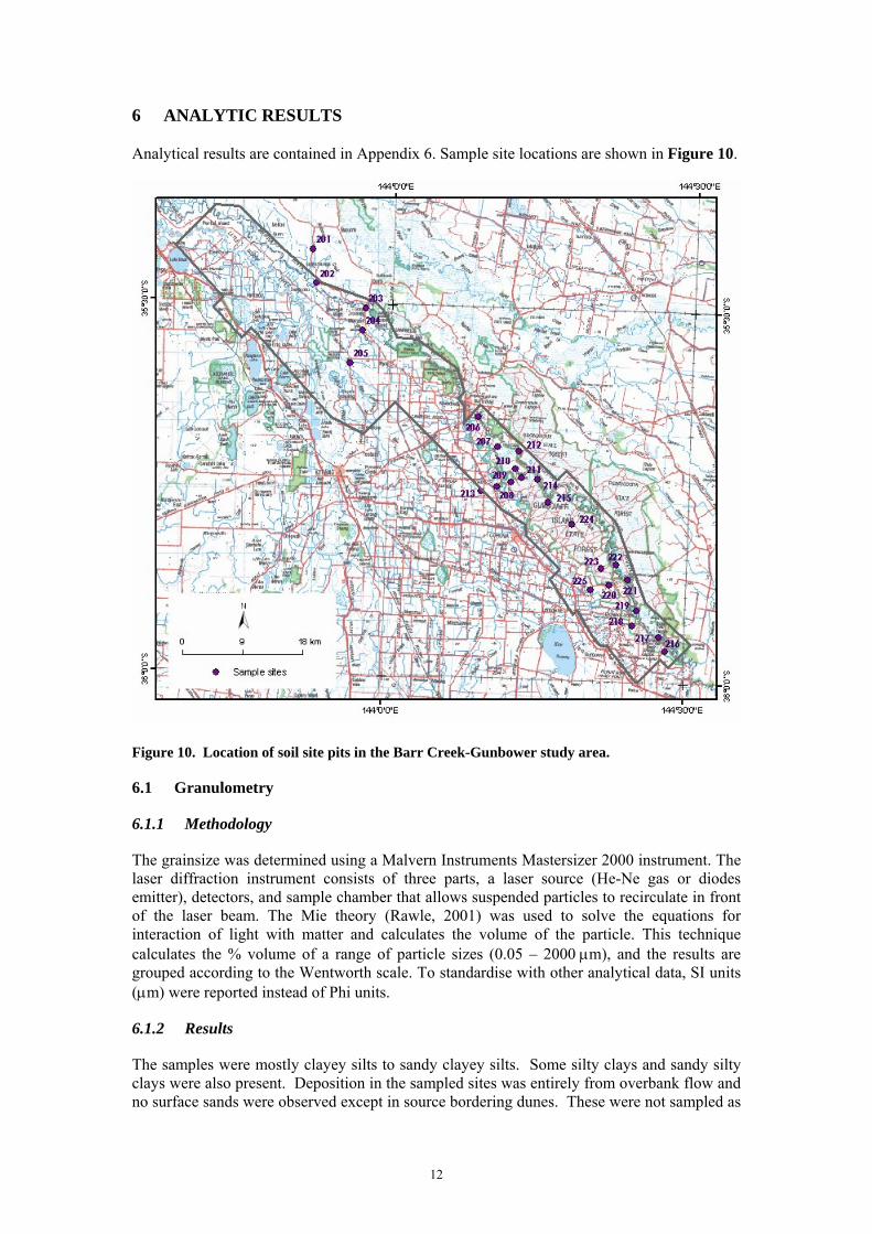
Analytical results are contained in Appendix 6. Sample site locations are shown in Figure 10.
Figure 10. Location of soil site pits in the Barr Creek-Gunbower study area.
6.1 Granulometry
6.1.1 Methodology
The grainsize was determined using a Malvern Instruments Mastersizer 2000 instrument. The laser diffraction instrument consists of three parts, a laser source (He-Ne gas or diodes emitter), detectors, and sample chamber that allows suspended particles to recirculate in front of the laser beam. The Mie theory (Rawle, 2001) was used to solve the equations for interaction of light with matter and calculates the volume of the particle. This technique calculates the % volume of a range of particle sizes (0.05 – 2000 µm), and the results are grouped according to the Wentworth scale. To standardise with other analytical data, SI units (µm) were reported instead of Phi units.
6.1.2 Results
The samples were mostly clayey silts to sandy clayey silts. Some silty clays and sandy silty clays were also present. Deposition in the sampled sites was entirely from overbank flow and no surface sands were observed except in source bordering dunes. These were not sampled as
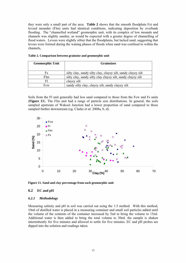
13
they were only a small part of the area. Table 2 shows that the smooth floodplain Fs) and leveed meander (Flm) units had identical conditions, indicating deposition by overbank flooding. The “channelled wetland” geomorphic unit, with its complex of low mounds and channels was slightly sandier, as would be expected with a greater degree of channelling of flood waters. Levees were slightly siltier that the floodplains, but lacked sand, suggesting that levees were formed during the waning phases of floods when sand was confined to within the channels,
Table 2. Comparison between grainsize and geomorphic unit
Geomorphic Unit Grainsizes
Fs silty clay, sandy silty clay, clayey silt, sandy clayey silt Flm silty clay, sandy silty clay clayey silt, sandy clayey silt Fl clayey silt
Fcw sandy silty clay, clayey silt, sandy clayey silt
Soils from the Fl unit generally had less sand compared to those from the Fcw and Fs units (Figure 11). The Flm unit had a range of particle size distributions. In general, the soils sampled upstream of Wakool Junction had a lower proportion of sand compared to those sampled further downstream (eg. Clarke et al. 2008a, b, d).
0
5
10
15
20
25
30
0 10 20 30 40 50 60 70Clay (%)
Sand
(%)
FcwFlFlmFs
Figure 11. Sand and clay percentage from each geomorphic unit
6.2 EC and pH
6.2.1 Methodology
Measuring salinity and pH in soil was carried out using the 1:5 method. With this method, 10ml of distilled water is placed in a measuring container and small soil particles added until the volume of the contents of the container increased by 5ml to bring the volume to 15ml. Additional water is then added to bring the total volume to 30ml. the sample is shaken intermittently for five minutes and allowed to settle for five minutes. EC and pH probes are dipped into the solution and readings taken.
14
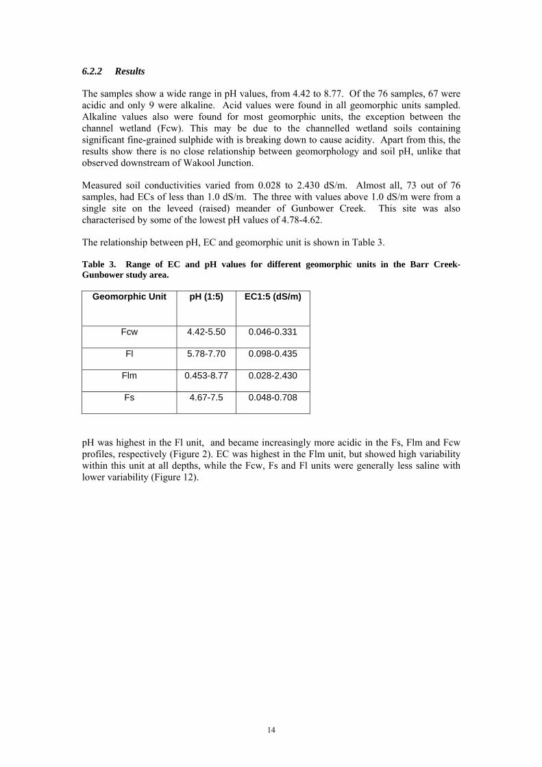
6.2.2 Results
The samples show a wide range in pH values, from 4.42 to 8.77. Of the 76 samples, 67 were acidic and only 9 were alkaline. Acid values were found in all geomorphic units sampled. Alkaline values also were found for most geomorphic units, the exception between the channel wetland (Fcw). This may be due to the channelled wetland soils containing significant fine-grained sulphide with is breaking down to cause acidity. Apart from this, the results show there is no close relationship between geomorphology and soil pH, unlike that observed downstream of Wakool Junction.
Measured soil conductivities varied from 0.028 to 2.430 dS/m. Almost all, 73 out of 76 samples, had ECs of less than 1.0 dS/m. The three with values above 1.0 dS/m were from a single site on the leveed (raised) meander of Gunbower Creek. This site was also characterised by some of the lowest pH values of 4.78-4.62.
The relationship between pH, EC and geomorphic unit is shown in Table 3.
Table 3. Range of EC and pH values for different geomorphic units in the Barr Creek-Gunbower study area.
Geomorphic Unit pH (1:5) EC1:5 (dS/m)
Fcw 4.42-5.50 0.046-0.331
Fl 5.78-7.70 0.098-0.435
Flm 0.453-8.77 0.028-2.430
Fs 4.67-7.5 0.048-0.708
pH was highest in the Fl unit, and became increasingly more acidic in the Fs, Flm and Fcw profiles, respectively (Figure 2). EC was highest in the Flm unit, but showed high variability within this unit at all depths, while the Fcw, Fs and Fl units were generally less saline with lower variability (Figure 12).

15
0
0.05
0.1
0.15
0.2
0.25
0.3
4.0 4.5 5.0 5.5 6.0 6.5 7.0 7.5 8.0pH1:5
Dep
th (
m)
FcwFlFlmFs
Figure 12. Mean pH profiles from each geomorphic unit. Note: horizontal bars indicate the standard error of the mean.
6.3 XRF geochemistry
6.3.1 Methodology
The samples were pulverized using a tungsten carbide mill and the elements were analyzed by XRF. For major element determination (SiO2, TiO2, Al2O3, Fe2O3, MnO, MgO, CaO, Na2O, K2O, P2O5, and S), samples were prepared as fused discs following the method of Norrish and Hutton (1964), with the exception that the flux used consisted of 12 parts lithium tetraborate to 22 parts lithium metaborate. The glass discs were analyzed on a PW2400 wavelength dispersive X-ray fluorescence (XRF) spectrometer. The 35 trace elements were determined on pressed powder samples using a SPECTRO X-Lab energy dispersive XRF spectrometer. The powders were also measured on a PW1400 wavelength dispersive XRF spectrometer for Sc, V and Cr, using methods described in Chappell (1991) and Norrish and Chappell (1967). Tungsten and Co were probably added to the samples during the milling process, and hence these elements have not been reported. The major elements and minor element values are shown as % and ppm respectively.
The percentage of volatile materials in the samples was determined using a LECO RC-412 multiphase carbon and water analyzer. Nitrogen was used as the carrier gas for combustion and the furnace control system allows the temperature of the furnace to be stepped and subjected to ramping (from 90 to 1040 oC). Water and carbon dioxide released from the minerals during combustion are detected by means of infrared absorption cells (IR-cells) and the results are then calculated as CO2 and H2O respectively.
6.3.2 Results
The primary purpose of the XRF analyses was to obtain measurements of the abundances of K, Th, and U, should detailed interpretation of the gamma-ray radiometric data be required.
Only a limited number of comparisons were made because of time limitations. Correlations between Na and Cl values were poor, owing to higher rainfall in area C compared to Area A. Under such conditions sodium would be taken up by clays while chloride would be flushed. The XRF results also reflect the high quartz content of the soils with high SiO2 concentrations across all geomorphic units and depths (Table 4).

16
6.4 XRD mineralogy
6.4.1 Methodology
Samples were analysed using both semi-quantitative XRD and qualitative PIMA methods. Samples for XRD were scanned on a Siemens D500 Diffractometer, from 2° to 70° 2θ, in 1° increments, 2 seconds per degree, using a Cu anode X-ray tube. Minerals were identified using Bruker Diffracplus and Siroquant V3 was used to quantify minerals. The samples are characterised by simple scans, containing predominant Quartz peaks with accessory mica (probably Muscovite), feldspar and clay (probably Kaolin). Specific feldspars have been identified according to best-fit of peaks. Further petrological work would be required to conclusively identify feldspars.
Table 4. Mean values of selected XRF analyses.
Geomorphic Unit
Depth (m)
Al2O3 (%)
CaO (%)
Cl (%)
Fe2O3 (%)
K2O (%)
Na2O (%)
S (%)
SiO2 (%) Th (%) U (%)
0.00-0.10 13.803 0.305 0.114 4.757 2.058 0.149 0.341 66.382 0.03000 0.006920.10-0.20 14.645 0.244 0.096 5.192 2.135 0.153 0.169 68.242 0.02900 0.00630Fcw 0.20-.030 14.658 0.247 0.099 5.016 2.124 0.165 0.161 68.373 0.02540 0.009520.00-0.10 9.425 0.961 0.201 3.268 1.810 0.228 0.464 65.183 0.01267 0.005170.10-0.20 10.141 0.352 0.142 3.633 2.036 0.283 0.156 76.328 0.03200 0.00793Fl 0.20-.030 10.846 0.285 0.156 3.818 2.063 0.288 0.158 75.560 0.02533 0.006570.00-0.10 12.812 0.369 0.481 4.399 2.276 0.206 0.344 66.844 0.02838 0.008030.10-0.20 13.843 0.265 0.471 5.075 2.450 0.214 0.202 68.276 0.03288 0.00786Flm 0.20-.030 13.892 0.250 0.411 5.375 2.447 0.228 0.183 68.236 0.03475 0.007850.00-0.10 11.930 0.383 0.136 4.077 2.158 0.236 0.249 70.873 0.02367 0.006260.10-0.20 12.970 0.340 0.180 4.852 2.229 0.237 0.177 70.405 0.02389 0.00450Fs 0.20-.030 13.270 0.326 0.237 5.069 2.267 0.244 0.155 70.283 0.02711 0.00571
6.4.2 Results
In the XRD results, quartz, muscovite, and kaolinite was present in all 77 samples. Orthoclase, and albite were present in many samples, 56 and 65 respectively. Microcline was found in less than a third of the samples, 21 in all. No calcite or dolomite was reported.
The absence of carbonate in these results confirm the near neutral to weakly acidic soil pH values measured in the field.
The abundance of mica and feldspars show that the sands fall into the sub-arkose compositional field, indicating that most are first cycle sediments derived from the eastern Australian highlands.
Further work on the clay mineralogy of the ample would be helpful to determine province of the materials, for example developing the results of Gingele and de Deckker (2004). This would require redoing the samples using clay separates and is beyond the scope of this project.
17
7 IMPLICATIONS
7.1 AEM modelling
Compared with the floodplain downstream of Wakool Junction the floodplain is comparatively simple (Clarke et al. 2007a, b. d). The floodplain thus has similarities with what occurs at Speewa. We predict that the influence of saline waters encroaching from the south from the Loddon Fan and expressing themselves in the past and present lake systems will show up in the AEM. We also predict that the presence of distinct wetland geomorphologies in the floodplain will be visible as a resistive groundwater mound associated with Gunbower Island and to the northern side of the Murray River. The presence of salt precipitates in the capillary fringe of the Gunbower island watertable means that show conducts may be expected in this area.
7.2 Hydrogeological issues
We predict that there will be four major hydrogeological units in the area. These will be the Loddon Fan to the south, the channels of Gunbower Creek and the Murray River, the channelled wetlands of Gunbower Island and to the north of the Murray river, and the non-wetland floodplain units of the Murray River up and down stream of Gunbower island.
The Loddon Fan will be dominated by north flowing and relatively saline waters at the terminal end of the London distributary system (Macumber 1968, 1991). Areas with exceptionally shallow groundwater are marked by the development of lakes, past areas of shallow groundwater are presented by floodplain lunettes where the lake themselves have been partly to completely filled in by floodplain sediments.
The stratigraphy of the channel aquifer is not known to the authors. However we assume that the channel of Gunbower Creek and the Murray River are connected to the basal sands of this unit and will recharge it. Recharge from Gunbower Creek may be more limited, owing to more sluggish flow the possibility exists that much of the channel is now lined by relatively impermeable silts and clays.
We hypothesise that the channelled wetlands of Gunbower Island are formed by a twofold process: 1) relatively elevated water tables from lateral flow out of the leveed channels of Gunbower Creek and the Murray River and 2), overflow of the Murray River in flood via distributaries associated with crevasse splays. The clay rich nature of the wetland soils and the elevated water tables means that once flooded water will persist for extended periods of time. It is also worth noting that the wetlands are almost certainly you features, because of the very recent (~550 years ago) migration of the Murray River to its present course (Stone 2006). This recent origin would explain absence of peat build ups normally found in wetland areas.
Up and downstream of Gunbower island non-wetland floodplain units of the Murray River have a smooth appearance similar to that shown by other parts of the Murray River floodplain upstream of Wakool Junction, such as those at Nyah and Speewa (Clarke et al. 2007c, e). We predict that groundwater beneath this type of floodplain will be somewhat deeper than beneath the floodplain characterised by channelled wetlands.
7.2.1 Flow
Our prediction is that there will be three components to the groundwater flow in the area. The first is the northern flow associated with the Loddon fan. The second is the general downstream flow through the basal channel sands aquifer. The third will be lateral follow away from the Murray River and, to a lesser degree, Gunbower Creek, recharging the aquifers beneath the floodplain.

18
7.2.2 Recharge
We predict that vertical recharge through the floodplain will be generally low. This is based on the back that almost all of the floodplain surface is sealed by clay. Because the meander belts are themselves now inactive, except for a handful on the Murray River, they too are sealed against vertical recharge. The exceptions might be where there are source bordering dunes which comprise perhaps 1% of the total area and may allow rainfall and standing floodwaters to bypass the clay seal and recharge the aquifers of the meander belts. Our prediction is therefore that lateral recharge from the Murray and, to a lesser degree, Gunbower Creek, is most important.
7.3 Relevance to land management questions
We conclude the following in response to the land management questions contained in Lawrie (2006).
1. What is the interaction between tree health and groundwater?
We expect that it should be possible to show geomorphic units will provide a proxy for hydrogeology and thus may be useful in explaining patterns in the variation of tree health in the floodplain environments.
2. What is the cumulative effect of soil salinity in the forest? How can we manage this?
The geomorphology, vegetation and surface materials maps and AEM data cannot answer this question. Vegetation modelling can determine cumulative salinity effects, but is beyond the scope of this project.
3. To what extent are trees building up salt in their root zones?
Measurements of soil ECs will assist in documenting the degree to which this has taken place. This will be the subject of a latter report
4. To what extent does off-site movement of salt into the Murray River occur?
This is primarily and AEM question. The geomorphic patterns can provide predictions as to possible patterns (such as ingression from the Loddon Fan to the south). We also expect the geomorphic and materials data to explain other aspects of the patterning that may emerge from the AEM data.
5. Is our forest flooding affecting groundwater levels beneath the areas under irrigation near the forest and/or affecting groundwater levels within the forest?
This will be primarily a result of the AEM survey. However, because Gunbower Creek still sustains some flow, we expect that there will be more conductivity between the water in the channel and the ground water than occurs beneath other channel systems.
6. What is the geographical distribution of salt within the forest? Where are the salt ‘hot spots’? Which trees are salt stressed and which are stressed because of groundwater levels?
The answer to this question will be primarily from AEM data.
7. What are the trends in salinity over time?
This cannot be readily answered by the geomorphic and surface materials information.
8. What is the extent of the threat posed to the forest by saline groundwater moving from irrigated land adjacent to the forest to beneath the forest?

19
Likewise this question cannot be readily answered by the geomorphic and surface materials information, but rather from hydrogeological, hydrochemical, and AEM data.
9. What is the affect of Torrumbarry Weir on salinity in the sediments downstream of the weir?
This question too cannot be readily answered by the geomorphic and surface materials information, but rather from hydrogeological, hydrochemical, and AEM data.
20
REFERENCES
Chappell, B.W. 1991. Trace element analysis of rocks by X-ray spectrometry. Advances in X-Ray Analysis 34, 263-276.
Churchward, H.M. 1961. Soil studies at Swan Hill, Victoria, Australia I. Soil layering Journal of Soil Science, 12(1), p.73-86.
Churchward, H.M. 1963a. Soil studies at Swan Hill, Victoria, Australia. II. Dune moulding and parna formation. Australian Journal of Soil Research 1(1) 103 – 116.
Churchward, H.M. 1963b. Soil studies at Swan Hill, Victoria, Australia. III. Some aspects of soil development on aeolian materials. Australian Journal of Soil Research 1(1) 117 – 128.
Churchward, H. M. 1963c. Soil studies at Swan Hill, Victoria, Australia IV. Groundsurface history and its expression in the array of soils. Australian Journal of Soil Research 1, 242-255.
Clarke, J. Pain, C., Wong, V., Apps, H., Gibson, D., Luckman, J., and Lawrie, K., 2007a. Geomorphology and Surface Materials: Liparoo to Robinvale. CRC LEME Restricted Report 258R.
Clarke, J., Wong, V., Gibson, D., Apps, H., Luckman, J., Pain C., and Lawrie, K. 2007b. Geomorphology and Surface Materials: Robinvale to Boundary Bend. CRC LEME Restricted Report 259R.
Clarke, J., Wong, V., Pain, C., V., Apps, H., Gibson, D., Luckman, J., and Lawrie, K. 2007c. Geomorphology and Surface Materials: Boundary Bend to Nyah. CRC LEME Restricted Report 260R.
Clarke, J. Wong, V., Pain, C., Apps, H., Gibson, D., Luckman, J., and Lawrie, K., 2007d. Geomorphology and Surface Materials: Lindsay to Wallpolla. CRC LEME Restricted Report 261R.
Clarke, J., Wong, V., Pain, C., Apps, H., Gibson, D., Luckman, J., and Lawrie, K. 2007e. Geomorphology and Surface Materials: Speewa. CRC LEME Restricted Report 263R.
Gingele, F.X. and De Deckker, P. 2004. Fingerprinting Australia's rivers with clay minerals and the application for the marine record of climate change. Australian Journal of Earth Sciences 51(3), 339-348.
Haynes, S. 2006. Barr Creek catchment investigation: ground water salinity mapping final report. SKM Pty. Ltd. Armadale, Victoria.
Lawrie. K. 2006 (comp.). Report by technical working group chair on proposed River Murray corridor (South Australian border to Gunbower) Victorian AEM mapping project. CRC LEME Restricted Technical Report 265R.
Macumber, P.G. 1968. Interrelationship between physiography, hydrology, sedimentation, and salinization of the Loddon River Plains, Australia. Journal of Hydrology 7, 39-57.
Macumber, P.G. 1991. Interaction between groundwater and surface systems in northern Victoria. Victoria Department of Conservation and Environment, Australia.

21
Norrish, K. and Chappell, B. W. 1967. X-ray fluorescence spectrography. In Zussman, J. (ed.) Physical methods in determinative mineralogy. Academic Press, London.
Norrish and Hutton 1969. 1969. An accurate X-ray spectrographic method for the analysis of a wide range of geological samples. Geochimica et Ccosmochica. Acta 33 431-453.
Rawle, A.F. 2003. Method development for particle size measurement by laser diffraction. Particulates Systems Analysis Conference (2003), Harrogate, UK
Stone, T. 2006. The late Holocene origin of the Murray River course, southeastern Australia. The Holocene 16(5) 771-778.

22
APPENDIX 1: ASTER data and interpretation
23
Surface properties map interpreted from ASTER data

24
APPENDIX 2: SPOT data and interpretation
25
Vegetation map interpreted from SPOT data

26
APPENDIX 3: DEM data and interpretation

27
Landforms interpreted from DEM data

28
APPENDIX 4: Gamma-ray data
750000
750000
780000
780000
810000
810000
602
90
70
602
90
70
6059
070
6059
070
0 10 20 km±Barr Creek - Gunbower
Ternary - gamma ray
29
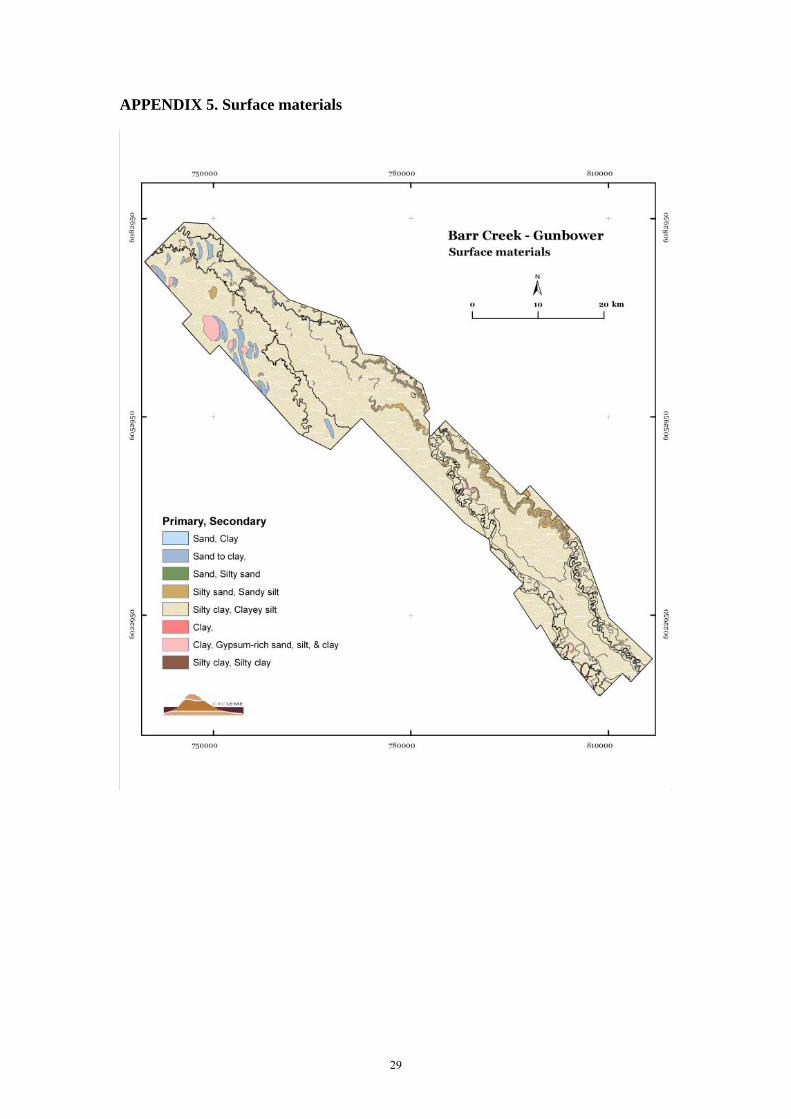
APPENDIX 5. Surface materials
30
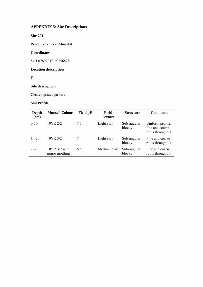
APPENDIX 5: Site Descriptions
Site 201
Road reserve near Murrabit
Coordinates
54H 0760201E 6075682E
Location description
Fs
Site description
Cleared grazed pasture
Soil Profile
Depth (cm)
Munsell Colour Field pH Field Texture
Structure Comments
0-10 10YR 2/2 7.5 Light clay Sub-angular blocky
Uniform profile; fine and coarse roots throughout
10-20 10YR 3/2 7 Light clay Sub-angular blocky
Fine and coarse roots throughout
20-30 10YR 3/2 with minor mottling
6.5 Medium clay Sub-angular blocky
Fine and coarse roots throughout
31
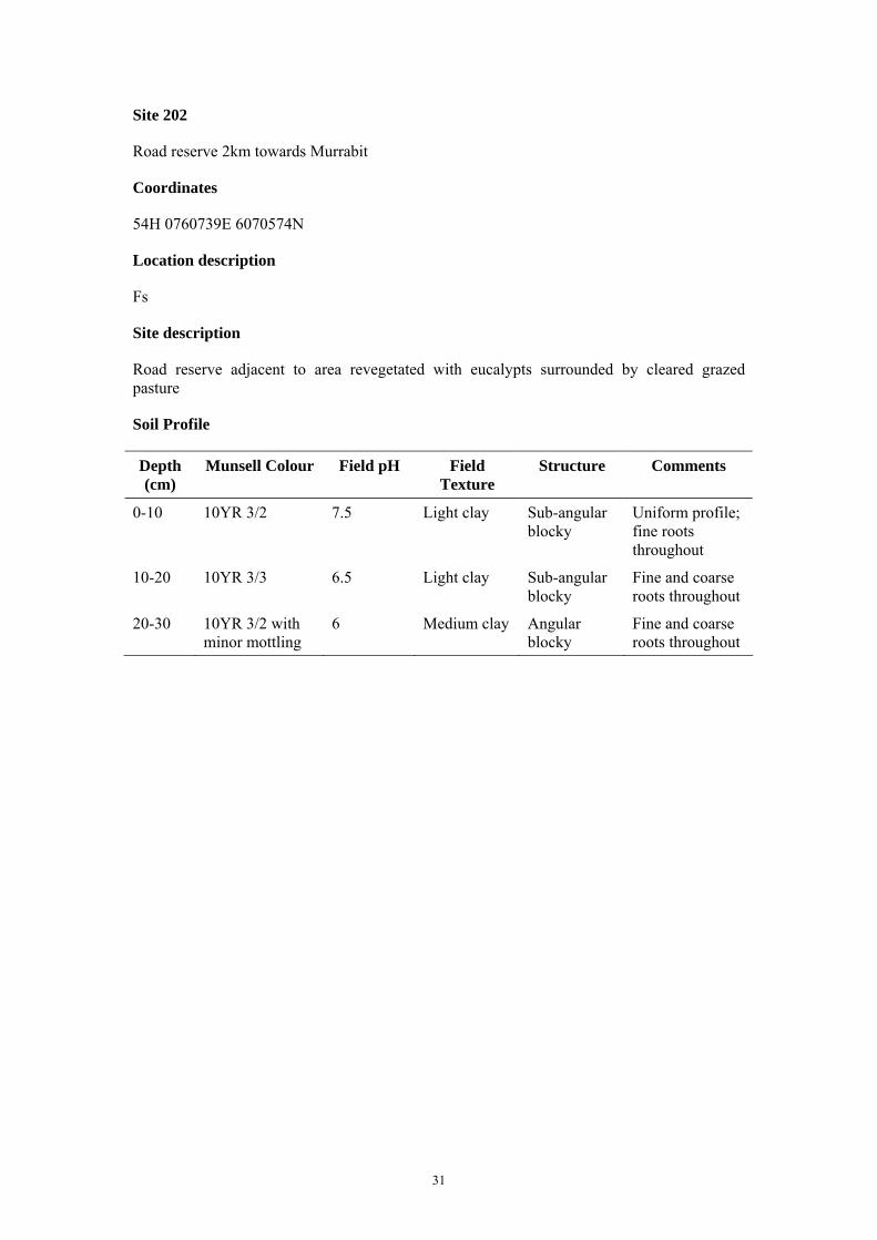
Site 202
Road reserve 2km towards Murrabit
Coordinates
54H 0760739E 6070574N
Location description
Fs
Site description
Road reserve adjacent to area revegetated with eucalypts surrounded by cleared grazed pasture
Soil Profile
Depth (cm)
Munsell Colour Field pH Field Texture
Structure Comments
0-10 10YR 3/2 7.5 Light clay Sub-angular blocky
Uniform profile; fine roots throughout
10-20 10YR 3/3 6.5 Light clay Sub-angular blocky
Fine and coarse roots throughout
20-30 10YR 3/2 with minor mottling
6 Medium clay Angular blocky
Fine and coarse roots throughout
32
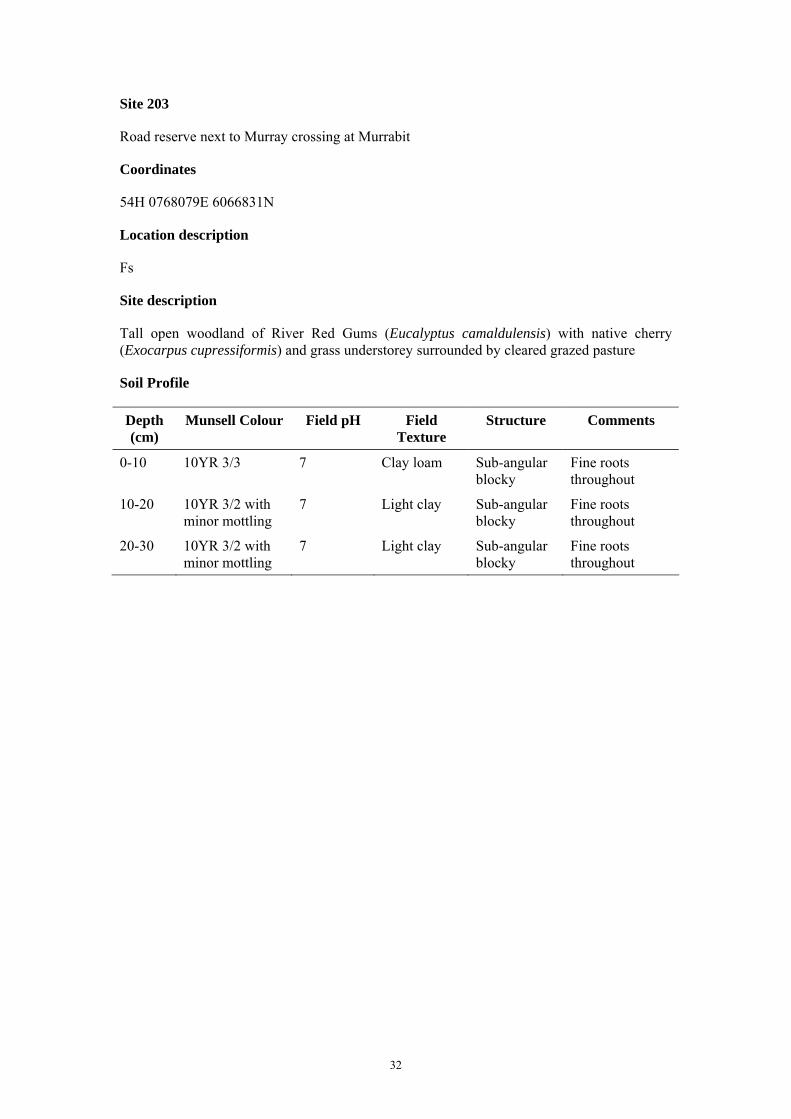
Site 203
Road reserve next to Murray crossing at Murrabit
Coordinates
54H 0768079E 6066831N
Location description
Fs
Site description
Tall open woodland of River Red Gums (Eucalyptus camaldulensis) with native cherry (Exocarpus cupressiformis) and grass understorey surrounded by cleared grazed pasture
Soil Profile
Depth (cm)
Munsell Colour Field pH Field Texture
Structure Comments
0-10 10YR 3/3 7 Clay loam Sub-angular blocky
Fine roots throughout
10-20 10YR 3/2 with minor mottling
7 Light clay Sub-angular blocky
Fine roots throughout
20-30 10YR 3/2 with minor mottling
7 Light clay Sub-angular blocky
Fine roots throughout
33
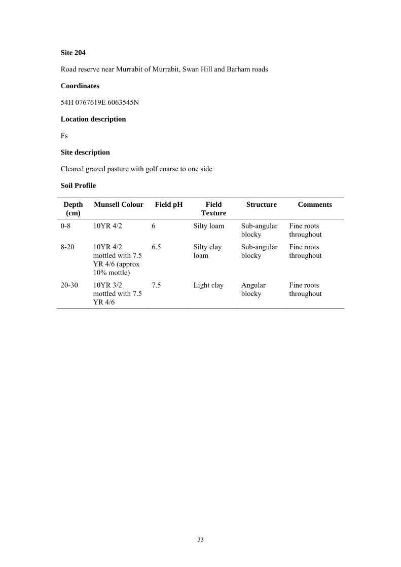
Site 204
Road reserve near Murrabit of Murrabit, Swan Hill and Barham roads
Coordinates
54H 0767619E 6063545N
Location description
Fs
Site description
Cleared grazed pasture with golf coarse to one side
Soil Profile
Depth (cm)
Munsell Colour Field pH Field Texture
Structure Comments
0-8 10YR 4/2 6 Silty loam Sub-angular blocky
Fine roots throughout
8-20 10YR 4/2 mottled with 7.5 YR 4/6 (approx 10% mottle)
6.5 Silty clay loam
Sub-angular blocky
Fine roots throughout
20-30 10YR 3/2 mottled with 7.5 YR 4/6
7.5 Light clay Angular blocky
Fine roots throughout
34
Site 205
Road reserve approximately 5 km south of Site 204
Coordinates
54H 0765768E 6058599N
Location description
Fs
Site description
Cleared grazed pasture with minor occurrences of saltbush
Soil Profile
Depth (cm)
Munsell Colour Field pH Field Texture
Structure Comments
0-10 2.5Y 3/1 7 Clay loam Sub-angular blocky
Uniform profile; fine roots throughout
10-20 10YR 3/1 7 Medium clay Sub-angular blocky
Fine roots throughout
20-30 2.5Y 3/1 with minor mottling
7.5 Medium clay Sub-angular blocky
Fine and coarse roots throughout
35
Site 206
Gunbower Island
Coordinates
54H 241721E 6051318N
Location description
Fcw
Site description
Open forest of River Red Gums with lower stratum of juvenile eucalypt trees and understorey of native cherry and grass
Soil Profile
Depth (cm)
Munsell Colour Field pH Field Texture
Structure Comments
0-4 10YR 5/3 7 Sandy loam Sub-angular blocky
Thin layer of litter on surface; organic material incorporated throughout layer; fine and coarse roots throughout
4-10 10YR 5/3 mottled with 10YR 5/8 (approx 10% mottle)
7 Clay loam Sub-angular blocky
Fine and coarse roots present
10-20 10YR 4/2 mottled with 10YR 5/8 (approx. 20% mottle)
6.5 Light clay Sub-angular blocky
Fine and coarse roots present
20-30 10YR 5/3 mottled with 10YR 5/8 (approx. 20% mottle)
6.5 Light clay Sub-angular blocky
Fine and coarse roots present; charcoal present
36
Site 207
Gunbower Island
Coordinates
54H 244899E 6047000N
Location description
Fcw: Five Mile Track
Site description
Woodland of River Red Gums of similar age with lower stratum of juvenile eucalypt trees and grassy understorey
Soil Profile
Depth (cm)
Munsell Colour Field pH Field Texture
Structure Comments
0-5 10YR 3/2 7 Silty loam Sub-angular blocky
Thin layer of litter and cryptogamic crust on surface; fine and coarse roots present; charcoal present
5-10 10YR 4/2 mottled with 10YR 4/6 (approx 20% mottle)
6.5 Silty clay loam
Sub-angular blocky
Fine and coarse roots present; charcoal present
10-20 10YR 4/2 mottled with 7.5R 5/8 (approx. 40% mottle)
6.5 Silty clay loam
Sub-angular blocky
Fine and coarse roots present; charcoal present
20-30 10YR 5/3 mottled with 7.5R 5/8 (approx. 40% mottle)
5.5 Silty clay loam
Angular blocky
Fine and coarse roots present; charcoal present

37
Site 208
Gunbower Island
Coordinates
54H 245080E 6041038N
Location description
Flm: abandoned levee next to Spence’s Bridge, Gunbower Creek
Site description
Woodland of River Red Gums with grassy understorey and saltbush (Atriplex sp.) on banks of creek and levee; Black Box (E. largiflorens) begins to dominate approximately 20 m from the channel
Soil Profile
Depth (cm)
Munsell Colour Field pH Field Texture
Structure Comments
0-4 10YR 3/2 8.5 Loam Sub-angular blocky
Fine and coarse roots present; charcoal present
4-10 10YR 5/2 7.5 Silty clay loam
Sub-angular blocky
Fine and coarse roots present; charcoal present
10-20 10YR 3/2 7.5 Clay loam Angular blocky
Fine and coarse roots present; charcoal present
20-30 10YR 3/2 8 Medium clay Angular blocky
Fine and coarse roots present; charcoal present
38
Site 209
Gunbower Island
Coordinates
54H 247221E 6041920N
Location description
Flm: Reedy Lagoon
Site description
Open woodland of River Red Gums with saltbush and grass understorey; area has been selectively logged
Soil Profile
Depth (cm)
Munsell Colour Field pH Field Texture
Structure Comments
0-5 10YR 3/2 6.5 Silty clay loam
Sub-angular blocky
Fine and coarse roots present
5-10 10YR 3/2 7 Silty clay loam
Sub-angular blocky
Fine and coarse roots present
10-20 10YR 4/3 7 Clay loam Sub-angular blocky
Fine and coarse roots present
20-30 10YR 4/3 7 Light clay Sub-angular blocky
Fine and coarse roots present

39
Site 210
Gunbower Island
Coordinates
54H 247733E 6043921N
Location description
Flm: Reedy Lagoon
Site description
Open woodland of mixed River Red Gums and Black Box with grassy understorey; trees are relatively young and roughly similar ages. Occasional older trees which are dead, dying or in poor health
Soil Profile
Depth (cm)
Munsell Colour Field pH Field Texture
Structure Comments
0-6 10YR 4/3 7 Loam Sub-angular blocky
Fine and coarse roots present; cryptogamic crust and thin litter layer on surface
6-10 10YR 4/2 mottled with 7.5YR 4/6 (approx. 10% mottle)
6.5 Medium clay Angular blocky
Fine and coarse roots present
10-20 10YR 4/2 mottled with 7.5YR 4/8 (approx. 10% mottle)
7 Medium clay Angular blocky
Fine and coarse roots present; charcoal present
20-30 10YR 3/2 mottled with 10YR 4/6 (approx. 10% mottle)
6.5 Medium clay Angular blocky
Fine and coarse roots present; charcoal present
40
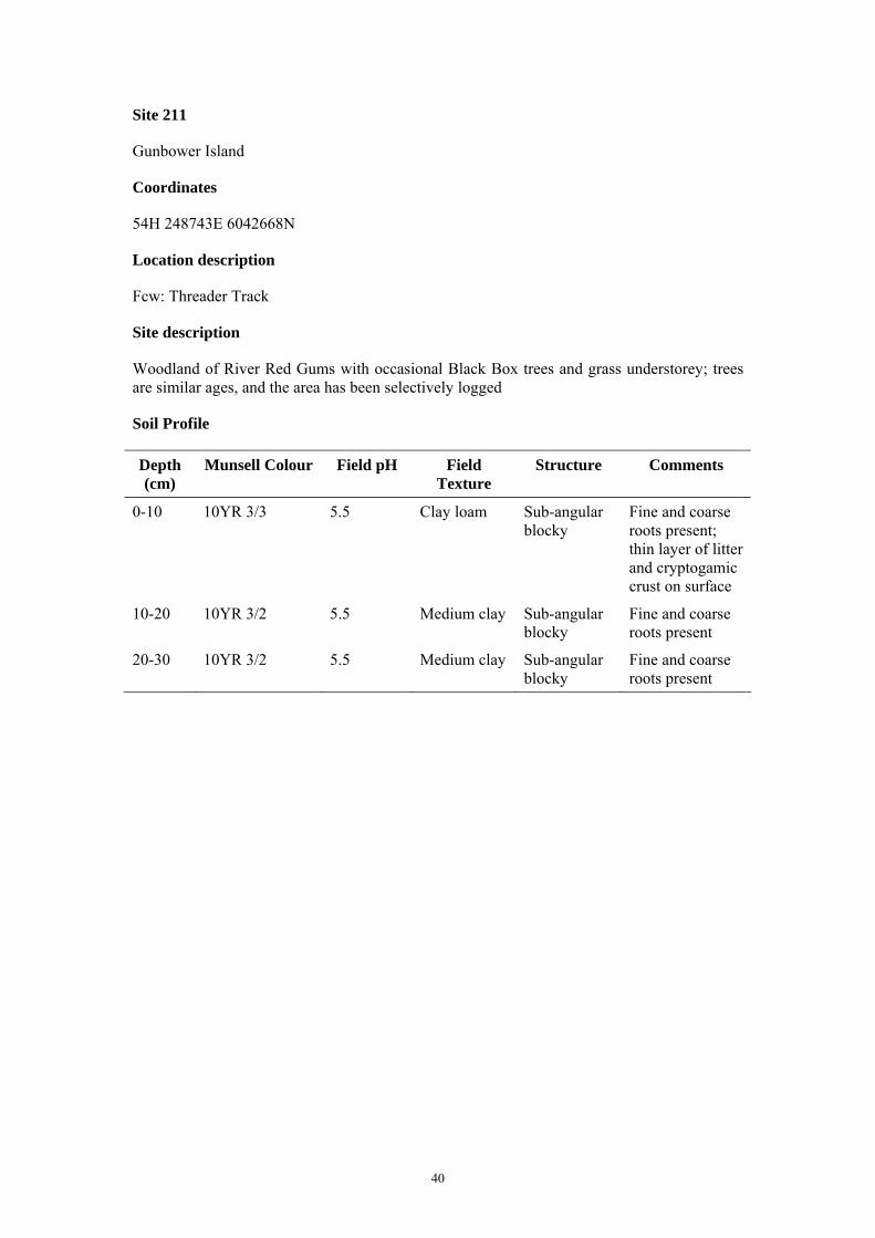
Site 211
Gunbower Island
Coordinates
54H 248743E 6042668N
Location description
Fcw: Threader Track
Site description
Woodland of River Red Gums with occasional Black Box trees and grass understorey; trees are similar ages, and the area has been selectively logged
Soil Profile
Depth (cm)
Munsell Colour Field pH Field Texture
Structure Comments
0-10 10YR 3/3 5.5 Clay loam Sub-angular blocky
Fine and coarse roots present; thin layer of litter and cryptogamic crust on surface
10-20 10YR 3/2 5.5 Medium clay Sub-angular blocky
Fine and coarse roots present
20-30 10YR 3/2 5.5 Medium clay Sub-angular blocky
Fine and coarse roots present
41
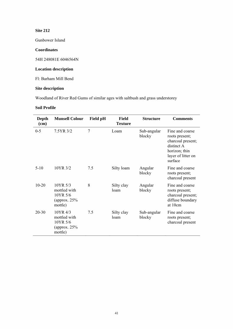
Site 212
Gunbower Island
Coordinates
54H 248081E 6046564N
Location description
Fl: Barham Mill Bend
Site description
Woodland of River Red Gums of similar ages with saltbush and grass understorey
Soil Profile
Depth (cm)
Munsell Colour Field pH Field Texture
Structure Comments
0-5 7.5YR 3/2 7 Loam Sub-angular blocky
Fine and coarse roots present; charcoal present; distinct A horizon; thin layer of litter on surface
5-10 10YR 3/2 7.5 Silty loam Angular blocky
Fine and coarse roots present; charcoal present
10-20 10YR 5/3 mottled with 10YR 5/6 (approx. 25% mottle)
8 Silty clay loam
Angular blocky
Fine and coarse roots present; charcoal present; diffuse boundary at 10cm
20-30 10YR 4/3 mottled with 10YR 5/6 (approx. 25% mottle)
7.5 Silty clay loam
Sub-angular blocky
Fine and coarse roots present; charcoal present

42
Site 213
Gunbower Island
Coordinates
54H 242744E 6040231N
Location description
Fl: between Milverton and Sovereign Bend
Site description
Tall open forest of River Red Gums with wild cherry and grass understorey
Soil Profile
Depth (cm)
Munsell Colour Field pH Field Texture
Structure Comments
0-6 10YR 2/2 7 Clay loam Sub-angular blocky
Fine and coarse roots present; charcoal present
6-10 2.5Y 5/2 mottled with 10YR 4/6 (approx. 10% mottle)
7.5 Clay loam Massive Fine and coarse roots present; charcoal present
10-20 10YR 5/2 mottled with 10YR 4/6 (approx. 25% mottle)
7 Clay loam Massive Fine and coarse roots present; charcoal present
20-30 10YR 5/2 mottled with 10YR 4/6
7 Clay loam Massive Fine and coarse roots present; charcoal present
43
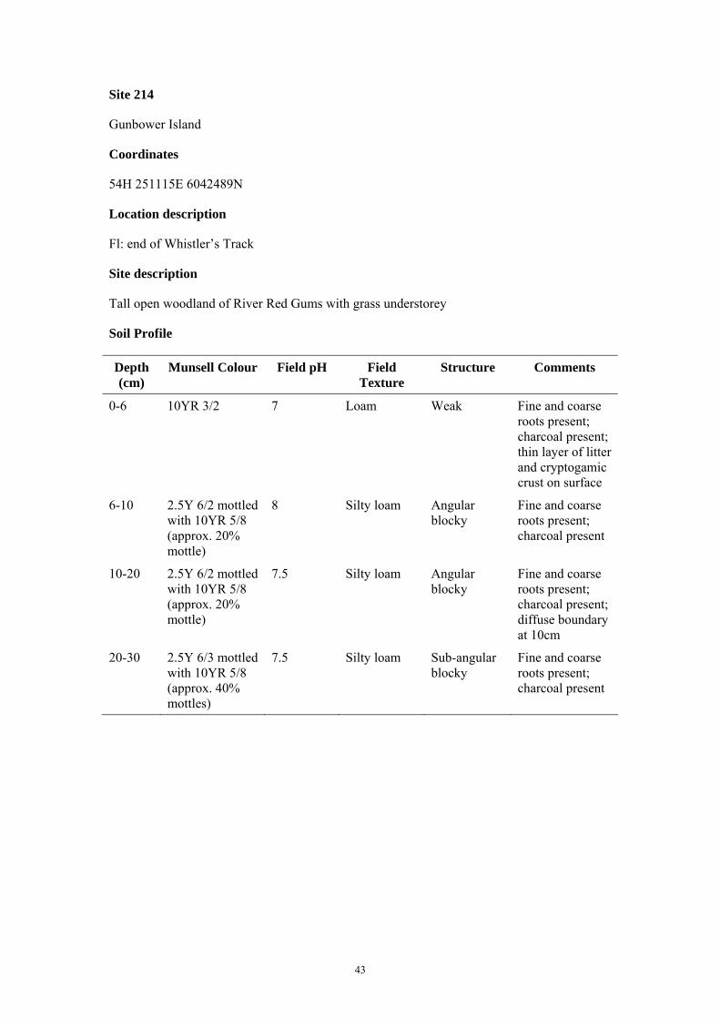
Site 214
Gunbower Island
Coordinates
54H 251115E 6042489N
Location description
Fl: end of Whistler’s Track
Site description
Tall open woodland of River Red Gums with grass understorey
Soil Profile
Depth (cm)
Munsell Colour Field pH Field Texture
Structure Comments
0-6 10YR 3/2 7 Loam Weak Fine and coarse roots present; charcoal present; thin layer of litter and cryptogamic crust on surface
6-10 2.5Y 6/2 mottled with 10YR 5/8 (approx. 20% mottle)
8 Silty loam Angular blocky
Fine and coarse roots present; charcoal present
10-20 2.5Y 6/2 mottled with 10YR 5/8 (approx. 20% mottle)
7.5 Silty loam Angular blocky
Fine and coarse roots present; charcoal present; diffuse boundary at 10cm
20-30 2.5Y 6/3 mottled with 10YR 5/8 (approx. 40% mottles)
7.5 Silty loam Sub-angular blocky
Fine and coarse roots present; charcoal present
44
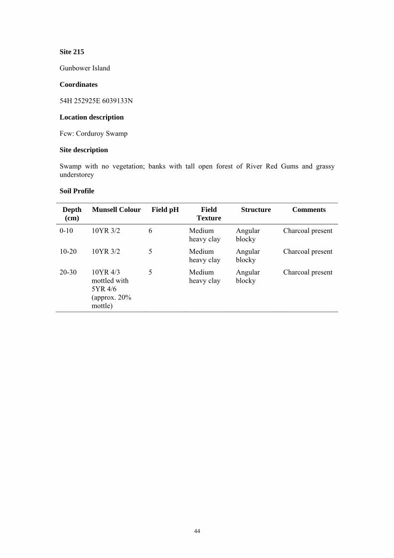
Site 215
Gunbower Island
Coordinates
54H 252925E 6039133N
Location description
Fcw: Corduroy Swamp
Site description
Swamp with no vegetation; banks with tall open forest of River Red Gums and grassy understorey
Soil Profile
Depth (cm)
Munsell Colour Field pH Field Texture
Structure Comments
0-10 10YR 3/2 6 Medium heavy clay
Angular blocky
Charcoal present
10-20 10YR 3/2 5 Medium heavy clay
Angular blocky
Charcoal present
20-30 10YR 4/3 mottled with 5YR 4/6 (approx. 20% mottle)
5 Medium heavy clay
Angular blocky
Charcoal present

45
Site 216
Gunbower Island
Coordinates
54H 271669E 6017867N
Location description
Fs: Torrumbarry Weir Rd
Site description
Low woodland of Black Box with lower stratum of Eumong (Acacia stenophylla) and Gold dust wattle (A. acinacea)
Soil Profile
Depth (cm)
Munsell Colour Field pH Field Texture
Structure Comments
0-10 10YR 4/4 7.5 Sandy loam Sub-angular blocky
Charcoal present; fine and coarse roots present
10-20 10YR 3/4 6.5 Clay loam Sub-angular blocky
Charcoal present; fine and coarse roots present
20-30 10YR 3/6 7 Clay loam Sub-angular blocky
Charcoal present; fine and coarse roots present
46
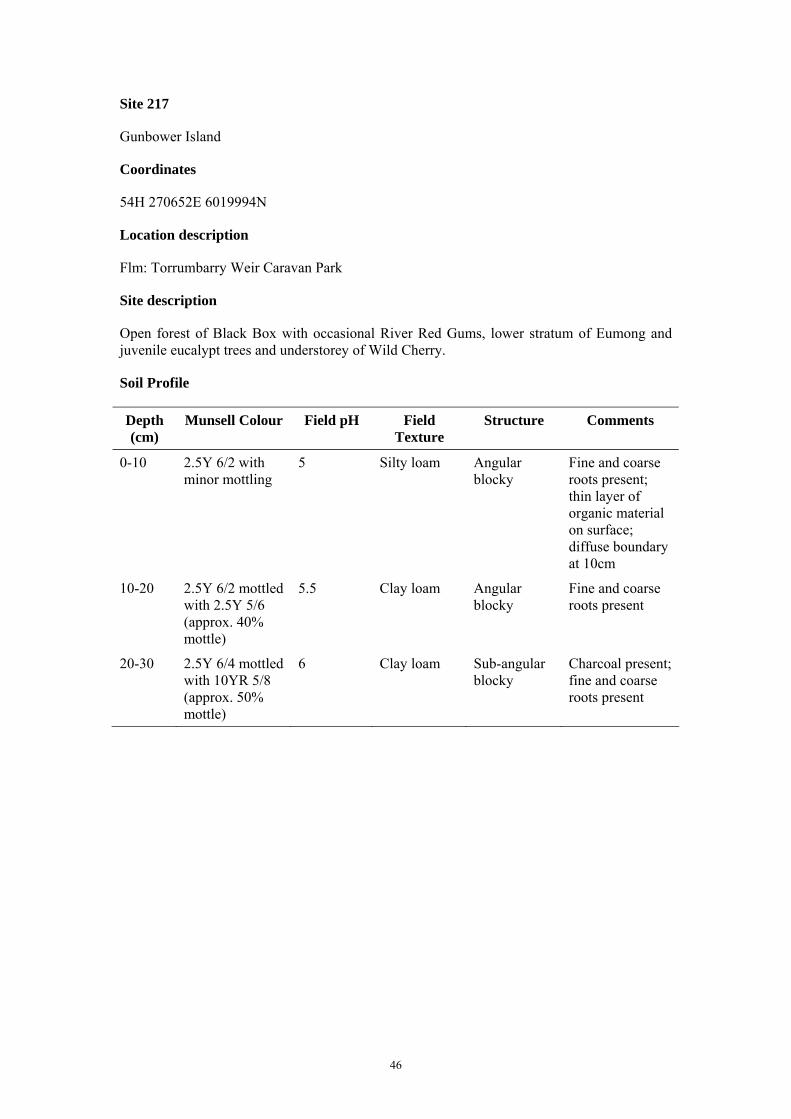
Site 217
Gunbower Island
Coordinates
54H 270652E 6019994N
Location description
Flm: Torrumbarry Weir Caravan Park
Site description
Open forest of Black Box with occasional River Red Gums, lower stratum of Eumong and juvenile eucalypt trees and understorey of Wild Cherry.
Soil Profile
Depth (cm)
Munsell Colour Field pH Field Texture
Structure Comments
0-10 2.5Y 6/2 with minor mottling
5 Silty loam Angular blocky
Fine and coarse roots present; thin layer of organic material on surface; diffuse boundary at 10cm
10-20 2.5Y 6/2 mottled with 2.5Y 5/6 (approx. 40% mottle)
5.5 Clay loam Angular blocky
Fine and coarse roots present
20-30 2.5Y 6/4 mottled with 10YR 5/8 (approx. 50% mottle)
6 Clay loam Sub-angular blocky
Charcoal present; fine and coarse roots present

47
Site 218
Gunbower Island
Coordinates
54H 266523E 6021499N
Location description
Fs: boat ramp
Site description
Low woodland of Black Box with lower stratum of juvenile eucalypts
Soil Profile
Depth (cm)
Munsell Colour Field pH Field Texture
Structure Comments
0-10 10YR 5/3 7 Silty loam Sub-angular blocky
Fine and coarse roots present; thin layer of litter and cryptogamic crust on surface
10-20 10YR 3/3 6 Clay loam Angular blocky
Fine and coarse roots present
20-30 10YR 3/3 with minor mottling
5 Clay loam Angular blocky
Fine and coarse roots present; diffuse boundary at 20cm

48
Site 219
Gunbower Island
Coordinates
54H 267084E 6023702N
Location description
Flm
Site description
Woodland of River Red Gums with lower stratum of juvenile eucalypts and grassy understorey
Soil Profile
Depth (cm)
Munsell Colour Field pH Field Texture
Structure Comments
0-10 10YR 5/4 mottled with 10YR 5/8 (approx. 10% mottle)
6 Silty loam Sub-angular blocky
Fine and coarse roots present; thin layer of litter on surface with thin topsoil layer 0-1 cm
10-15 10YR 6/3 mottled with 10YR 5/8 (approx. 40% mottle)
5 Silty loam Sub-angular blocky
Fine and coarse roots present; diffuse boundary at 15cm
15-20 10YR 5/3 mottled with 7.5YR 2.5/3 (approx 30% mottle) and minor mottles of 10YR 5/8
5 Silty clay loam
Sub-angular blocky
Fine and coarse roots present
20-30 10YR 5/3 mottled with 7.5YR 4/3
4 Silty clay loam
Sub-angular blocky
Fine and coarse roots present; charcoal present
49
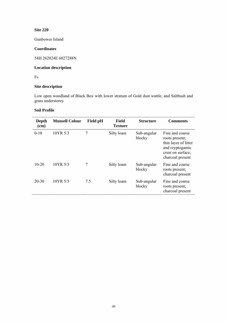
Site 220
Gunbower Island
Coordinates
54H 262824E 6027288N
Location description
Fs
Site description
Low open woodland of Black Box with lower stratum of Gold dust wattle, and Saltbush and grass understorey
Soil Profile
Depth (cm)
Munsell Colour Field pH Field Texture
Structure Comments
0-10 10YR 5/3 7 Silty loam Sub-angular blocky
Fine and coarse roots present; thin layer of litter and cryptogamic crust on surface; charcoal present
10-20 10YR 5/3 7 Silty loam Sub-angular blocky
Fine and coarse roots present; charcoal present
20-30 10YR 5/3 7.5 Silty loam Sub-angular blocky
Fine and coarse roots present; charcoal present
50
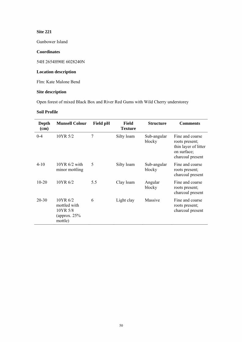
Site 221
Gunbower Island
Coordinates
54H 2654H90E 6028240N
Location description
Flm: Kate Malone Bend
Site description
Open forest of mixed Black Box and River Red Gums with Wild Cherry understorey
Soil Profile
Depth (cm)
Munsell Colour Field pH Field Texture
Structure Comments
0-4 10YR 5/2 7 Silty loam Sub-angular blocky
Fine and coarse roots present; thin layer of litter on surface; charcoal present
4-10 10YR 6/2 with minor mottling
5 Silty loam Sub-angular blocky
Fine and coarse roots present; charcoal present
10-20 10YR 6/2 5.5 Clay loam Angular blocky
Fine and coarse roots present; charcoal present
20-30 10YR 6/2 mottled with 10YR 5/8 (approx. 25% mottle)
6 Light clay Massive Fine and coarse roots present; charcoal present

51
Site 222
Gunbower Island
Coordinates
54H 263655E 6030434N
Location description
Flm: Halfway Bend
Site description
Open forest of River Red Gums with occasional Black Box trees and Wild Cherry, native grass and Acacia sp. understorey
Soil Profile
Depth (cm)
Munsell Colour Field pH Field Texture
Structure Comments
0-4 10YR 3/4 6 Silty loam Sub-angular blocky
Fine and coarse roots present; layer of litter on surface; organic layer relatively unconsolidated
4-10 10YR 3/2 with minor mottling
5.5 Silty loam Sub-angular blocky
Fine and coarse roots present
10-20 10YR mottled with 7.5YR 5/8 and 7.5YR 2.5/3 (approx. 40% mottle)
5.5 Silty clay loam
Sub-angular blocky
Fine and coarse roots present
20-30 10YR 4/2 mottled with 10YR 4/6 (approx. 40% mottle)
5 Light clay Sub-angular blocky
Fine and coarse roots present

52
Site 223
Gunbower Island
Coordinates
54H 261416E 6029803N
Location description
Fs: Corner of Stanton and Central Track
Site description
Woodland of Black Box with River Red Gums lining nearby drainage line and understorey of grass
Soil Profile
Depth (cm)
Munsell Colour Field pH Field Texture
Structure Comments
0-10 10YR 5/3 with minor mottling
5.5 Silty loam Sub-angular blocky
Fine and coarse roots present; thin layer of litter and cryptogamic crust on surface; charcoal present
10-20 10YR 6/2 with minor mottling
5.5 Silty loam Sub-angular blocky
Fine and coarse roots present; extensive charcoal present
20-30 10YR 6/2 mottled with 10YR 5/6 (approx. 10% mottle)
5.5 Silty loam Sub-angular blocky
Fine and coarse roots present; charcoal present
53
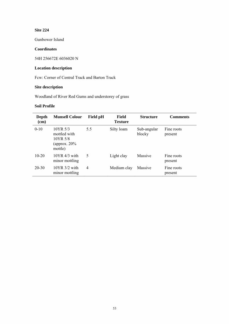
Site 224
Gunbower Island
Coordinates
54H 256672E 6036020 N
Location description
Fcw: Corner of Central Track and Barton Track
Site description
Woodland of River Red Gums and understorey of grass
Soil Profile
Depth (cm)
Munsell Colour Field pH Field Texture
Structure Comments
0-10 10YR 5/3 mottled with 10YR 5/8 (approx. 20% mottle)
5.5 Silty loam Sub-angular blocky
Fine roots present
10-20 10YR 4/3 with minor mottling
5 Light clay Massive Fine roots present
20-30 10YR 3/2 with minor mottling
4 Medium clay Massive Fine roots present
54
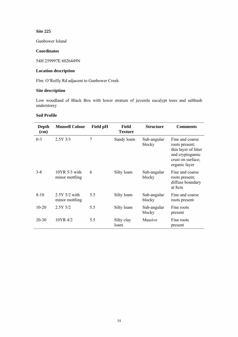
Site 225
Gunbower Island
Coordinates
54H 259997E 6026449N
Location description
Flm: O’Reilly Rd adjacent to Gunbower Creek
Site description
Low woodland of Black Box with lower stratum of juvenile eucalypt trees and saltbush understorey
Soil Profile
Depth (cm)
Munsell Colour Field pH Field Texture
Structure Comments
0-3 2.5Y 3/3 7 Sandy loam Sub-angular blocky
Fine and coarse roots present; thin layer of litter and cryptogamic crust on surface; organic layer
3-8 10YR 5/3 with minor mottling
6 Silty loam Sub-angular blocky
Fine and coarse roots present; diffuse boundary at 8cm
8-10 2.5Y 5/2 with minor mottling
5.5 Silty loam Sub-angular blocky
Fine and coarse roots present
10-20 2.5Y 5/2 5.5 Silty loam Sub-angular blocky
Fine roots present
20-30 10YR 4/2 5.5 Silty clay loam
Massive Fine roots present

1
APPENDIX 6: Analytical Results
Appendix 6.1: Barr Creek Gunbower EC and pH results
Site_no Easting Northing Zone Top depth (m)
Base depth (m)
Sample no Sample ID Geomorphic
Unit pH (1:5) EC1:5 (dS/m)
Moisture Content
(%) 201 760201.0 6075682.0 54 0.1 0.2 1937358 2007735057002 Fs 6.13 0.249 16.08 201 760201.0 6075682.0 54 0 0.1 1937357 2007735057001 Fs 6.46 0.288 19.20 201 760201.0 6075682.0 54 0.2 0.3 1937359 2007735057003 Fs 5.51 0.363 14.50 202 760739.0 6070574.0 54 0.2 0.3 1937362 2007735058003 Fs 5.51 0.104 17.08 202 760739.0 6070574.0 54 0.1 0.2 1937361 2007735058002 Fs 5.27 0.208 20.00 202 760739.0 6070574.0 54 0 0.1 1937360 2007735058001 Fs 5.63 0.370 19.63 203 768079.0 6066831.0 54 0.2 0.3 1937365 2007735059003 Fs 5.86 0.072 17.48 203 768079.0 6066831.0 54 0.1 0.2 1937364 2007735059002 Fs 5.64 0.095 16.38 203 768079.0 6066831.0 54 0 0.1 1937363 2007735059001 Fs 5.35 0.160 16.10 204 767619.0 6063545.0 54 0.2 0.3 1937368 2007735060003 Fs 6.24 0.048 15.98 204 767619.0 6063545.0 54 0.1 0.2 1937367 2007735060002 Fs 5.95 0.051 12.88 204 767619.0 6063545.0 54 0 0.1 1937366 2007735060001 Fs 4.87 0.124 12.13 205 765768.0 6058599.0 54 0 0.1 1937369 2007735061001 Fs 5.80 0.346 18.58 205 765768.0 6058599.0 54 0.1 0.2 1937370 2007735061002 Fs 6.12 0.421 17.71 205 765768.0 6058599.0 54 0.2 0.3 1937371 2007735061003 Fs 6.32 0.708 17.33 206 784958.9 6050503.1 54 0.1 0.2 1937373 2007735062002 Fcw 4.42 0.050 11.13 206 784958.9 6050503.1 54 0.2 0.3 1937374 2007735062003 Fcw 5.50 0.064 9.98 206 784958.9 6050503.1 54 0 0.1 1937372 2007735062001 Fcw 5.14 0.169 12.00 207 787867.9 6045998.2 54 0.2 0.3 1937377 2007735063003 Fcw 5.05 0.072 13.25 207 787867.9 6045998.2 54 0.1 0.2 1937376 2007735063002 Fcw 5.12 0.086 15.36 207 787867.9 6045998.2 54 0 0.1 1937375 2007735063001 Fcw 4.72 0.167 16.08 208 787684.1 6040035.0 54 0.2 0.3 1937380 2007735064003 Flm 6.89 0.297 12.38 208 787684.1 6040035.0 54 0 0.1 1937378 2007735064001 Flm 8.77 0.379 13.13 208 787684.1 6040035.0 54 0.1 0.2 1937379 2007735064002 Flm 8.25 0.383 11.13 209 789875.5 6040784.6 54 0.2 0.3 1937383 2007735065003 Flm 6.70 0.028 10.35 209 789875.5 6040784.6 54 0.1 0.2 1937382 2007735065002 Flm 6.50 0.038 11.11 209 789875.5 6040784.6 54 0 0.1 1937381 2007735065001 Flm 5.52 0.161 13.23 210 790509.1 6042751.0 54 0.2 0.3 1937386 2007735066003 Flm 5.52 0.035 11.49 210 790509.1 6042751.0 54 0.1 0.2 1937385 2007735066002 Flm 5.15 0.080 10.60 210 790509.1 6042751.0 54 0 0.1 1937384 2007735066001 Flm 4.97 0.129 11.75 211 791440.8 6041438.2 54 0.1 0.2 1937388 2007735067002 Fcw 5.45 0.041 20.55 211 791440.8 6041438.2 54 0.2 0.3 1937389 2007735067003 Fcw 5.17 0.080 21.25 211 791440.8 6041438.2 54 0 0.1 1937387 2007735067001 Fcw 4.65 0.265 23.44 212 791018.1 6045368.5 54 0.1 0.2 1937391 2007735068002 Fl 7.52 0.100 10.35 212 791018.1 6045368.5 54 0.2 0.3 1937392 2007735068003 Fl 7.70 0.122 8.49 212 791018.1 6045368.5 54 0 0.1 1937390 2007735068001 Fl 6.08 0.300 14.98 213 785302.6 6039372.3 54 0.2 0.3 1937395 2007735069003 Fl 6.37 0.098 12.34 213 785302.6 6039372.3 54 0.1 0.2 1937394 2007735069002 Fl 6.72 0.140 11.85 213 785302.6 6039372.3 54 0 0.1 1937393 2007735069001 Fl 6.06 0.435 16.21 214 793798.1 6041114.4 54 0.1 0.2 1937397 2007735070002 Fl 7.54 0.198 7.98 214 793798.1 6041114.4 54 0.2 0.3 1937398 2007735070003 Fl 7.10 0.211 8.35 214 793798.1 6041114.4 54 0 0.1 1937396 2007735070001 Fl 5.78 0.388 15.13

2
Site_no Easting Northing Zone Top depth (m)
Base depth (m)
Sample NO Sample ID Geomorphic
Unit pH (1:5) EC1:5 (dS/m)
Moisture Content
(%) 215 795399.9 6037652.9 54 0.2 0.3 1937401 2007735071003 Fcw 4.70 0.113 23.07 215 795399.9 6037652.9 54 0.1 0.2 1937400 2007735071002 Fcw 4.55 0.168 22.35 215 795399.9 6037652.9 54 0 0.1 1937399 2007735071001 Fcw 4.77 0.331 20.92 216 812811.8 6015267.2 54 0.1 0.2 1937403 2007735072002 Fs 6.30 0.120 7.18 216 812811.8 6015267.2 54 0 0.1 1937402 2007735072001 Fs 6.95 0.140 7.11 216 812811.8 6015267.2 54 0.2 0.3 1937404 2007735072003 Fs 7.01 0.203 9.95 217 811927.0 6017453.9 54 0.2 0.3 1937407 2007735073003 Flm 5.12 0.052 11.08 217 811927.0 6017453.9 54 0.1 0.2 1937406 2007735073002 Flm 5.10 0.060 11.35 217 811927.0 6017453.9 54 0 0.1 1937405 2007735073001 Flm 5.18 0.393 14.50 218 807896.1 6019210.7 54 0 0.1 1937408 2007735074001 Fs 5.07 0.303 7.99 218 807896.1 6019210.7 54 0.1 0.2 1937409 2007735074002 Fs 4.73 0.376 10.81 218 807896.1 6019210.7 54 0.2 0.3 1937410 2007735074003 Fs 4.67 0.378 12.11 219 808591.7 6021376.2 54 0.2 0.3 1937413 2007735076003 Flm 5.05 0.055 10.88 219 808591.7 6021376.2 54 0.1 0.2 1937412 2007735076002 Flm 4.80 0.077 13.13 219 808591.7 6021376.2 54 0 0.1 1937411 2007735075001 Flm 4.53 0.162 12.23 220 804558.0 6025218.8 54 0 0.1 1937414 2007735077001 Fs 6.18 0.081 7.11 220 804558.0 6025218.8 54 0.1 0.2 1937415 2007735077002 Fs 7.02 0.106 7.25 220 804558.0 6025218.8 54 0.2 0.3 1937416 2007735077003 Fs 7.50 0.150 8.23 221 807278.6 6026005.8 54 0.1 0.2 1937418 2007735078002 Flm 4.85 0.217 15.84 221 807278.6 6026005.8 54 0 0.1 1937417 2007735078001 Flm 4.80 0.286 10.60 221 807278.6 6026005.8 54 0.2 0.3 1937419 2007735078003 Flm 5.22 0.334 11.38 222 805580.9 6028309.3 54 0.2 0.3 1937422 2007735079003 Flm 5.00 0.135 16.13 222 805580.9 6028309.3 54 0.1 0.2 1937421 2007735079002 Flm 4.96 0.173 10.50 222 805580.9 6028309.3 54 0 0.1 1937420 2007735079001 Flm 4.80 0.499 22.38 223 803306.4 6027816.5 54 0 0.1 1937423 2007735080001 Fs 5.01 0.059 12.59 223 803306.4 6027816.5 54 0.1 0.2 1937424 2007735080002 Fs 5.46 0.065 11.63 223 803306.4 6027816.5 54 0.2 0.3 1937425 2007735080003 Fs 5.35 0.075 13.00 224 798950.5 6034315.2 54 0.2 0.3 1937428 2007735080003 Fcw 5.02 0.046 13.23 224 798950.5 6034315.2 54 0.1 0.2 1937427 2007735080002 Fcw 5.09 0.048 11.22 224 798950.5 6034315.2 54 0 0.1 1937426 2007735080001 Fcw 4.74 0.210 12.00 225 801683.6 6024554.5 54 0.2 0.3 1937431 2007735081003 Flm 4.78 1.854 15.46 225 801683.6 6024554.5 54 0.1 0.2 1937430 2007735081002 Flm 4.62 2.110 14.75 225 801683.6 6024554.5 54 0 0.1 1937429 2007735081001 Flm 4.68 2.430 17.88

3
Appendix 6.2: Barr Creek Gunbower laser grainsize
Site no. Easting Northing Zone Geomorphic Unit
Top depth (m)
Base depth (m) Sample No. Sample ID
% Clay (0.01-
3.9um)
% Silt (3.9-62.5um)
% Sand (62.5-
2000um)
201 760201 6075682 54 Fs 0 0.1 1937357 2007735057001 37.20793 47.609319 15.182751 sandy clayey silt 201 760201 6075682 54 Fs 0.1 0.2 1937358 2007735057002 42.706157 44.138033 13.155809 sandy clayey silt 201 760201 6075682 54 Fs 0.2 0.3 1937359 2007735057003 45.631886 40.963323 13.404791 sandy silty clay 202 760739 6070574 54 Fs 0.2 0.3 1937362 2007735058003 33.095884 59.939033 6.965083 clayey silt 202 760739 6070574 54 Fs 0 0.1 1937360 2007735058001 41.521015 45.885404 12.59358 sandy clayey silt 202 760739 6070574 54 Fs 0.1 0.2 1937361 2007735058002 37.679868 52.149291 10.170841 sandy clayey silt 203 768079 6066831 54 Fs 0 0.1 1937363 2007735059001 50.015366 37.110309 12.874326 sandy silty clay 203 768079 6066831 54 Fs 0.1 0.2 1937364 2007735059002 49.099485 38.509471 12.391043 sandy silty clay 203 768079 6066831 54 Fs 0.2 0.3 1937365 2007735059003 44.192393 37.534738 18.272869 sandy silty clay 204 767619 6063545 54 Fs 0 0.1 1937366 2007735060001 37.742208 46.660448 15.597344 sandy clayey silt 204 767619 6063545 54 Fs 0.1 0.2 1937367 2007735060002 36.700778 44.299135 19.000087 sandy clayey silt 204 767619 6063545 54 Fs 0.2 0.3 1937368 2007735060003 41.265627 42.66057 16.073803 sandy clayey silt 205 765768 6058599 54 Fs 0 0.1 1937369 2007735061001 46.794073 48.729043 4.476884 sandy silty clay 205 765768 6058599 54 Fs 0.1 0.2 1937370 2007735061002 52.982102 41.783787 5.234111 silty clay 205 765768 6058599 54 Fs 0.2 0.3 1937371 2007735061003 51.941135 42.585594 5.473271 silty clay 206 241721 6051318 55 Fcw 0 0.1 1937372 2007735062001 40.750578 49.255148 9.994274 clayey silt 206 241721 6051318 54 Fcw 0.1 0.2 1937373 2007735062002 47.356215 50.040586 2.603199 clayey silt 206 241721 6051318 54 Fcw 0.2 0.3 1937374 2007735062003 47.472826 49.786474 2.7407 clayey silt 207 244899 6047000 54 Fcw 0 0.1 1937375 2007735063001 27.703778 53.362484 18.933738 sandy clayey silt 207 244899 6047000 54 Fcw 0.1 0.2 1937376 2007735063002 25.366537 56.333751 18.299712 sandy clayey silt 207 244899 6047000 54 Fcw 0.2 0.3 1937377 2007735063003 25.791188 56.297087 17.911725 sandy clayey silt 208 245080 6041038 54 Flm 0.1 0.2 1937379 2007735064002 43.613094 43.741172 12.645734 sandy clayey silt 208 245080 6041038 54 Flm 0 0.1 1937378 2007735064001 46.803155 45.513705 7.68314 silty clay 208 245080 6041038 54 Flm 0.2 0.3 1937380 2007735064003 53.440828 40.879975 5.679197 silty clay 209 247221 6041920 54 Flm 0 0.1 1937381 2007735065001 34.847821 55.952553 9.199626 clayey silt 209 247221 6041920 54 Flm 0.1 0.2 1937382 2007735065002 40.401517 48.648933 10.94955 sandy clayey silt 209 247221 6041920 54 Flm 0.2 0.3 1937383 2007735065003 41.148838 47.162653 11.688509 sandy clayey silt 210 247733 6043921 54 Flm 0.1 0.2 1937385 2007735066002 35.025095 50.344129 14.630776 sandy clayey silt 210 247733 6043921 54 Flm 0.2 0.3 1937386 2007735066003 32.86004 50.18143 16.95853 sandy clayey silt 210 247733 6043921 54 Flm 0 0.1 1937384 2007735066001 50.880955 41.078526 8.040519 sandy silty clay 211 248743 6042668 54 Fcw 0 0.1 1937387 2007735067001 42.885163 49.001344 8.113493 clayey silt 211 248743 6042668 55 Fcw 0.2 0.3 1937389 2007735067003 41.081756 44.17339 14.744854 sandy clayey silt 211 248743 6042668 54 Fcw 0.1 0.2 1937388 2007735067002 47.092808 42.281226 10.625967 sandy silty clay 212 248081 6046564 54 Fl 0 0.1 1937390 2007735068001 31.206117 59.974035 8.819847 clayey silt 212 248081 6046564 54 Fl 0.1 0.2 1937391 2007735068002 23.312793 66.741202 9.946005 clayey silt 212 248081 6046564 54 Fl 0.2 0.3 1937392 2007735068003 25.158632 66.001577 8.83979 clayey silt 213 242744 6040231 54 Fl 0 0.1 1937393 2007735069001 44.348298 52.150801 3.500901 clayey silt 213 242744 6040231 54 Fl 0.1 0.2 1937394 2007735069002 38.552963 57.09477 4.352267 clayey silt 213 242744 6040231 54 Fl 0.2 0.3 1937395 2007735069003 42.785766 53.539078 3.675156 clayey silt 214 251115 6042489 54 Fl 0 0.1 1937396 2007735070001 27.489922 65.892454 6.617624 clayey silt 214 251115 6042489 54 Fl 0.1 0.2 1937397 2007735070002 27.748394 63.93516 8.316446 clayey silt 214 251115 6042489 54 Fl 0.2 0.3 1937398 2007735070003 30.358486 63.156857 6.484658 clayey silt

4
Site no. Easting Northing Zone Geomorphic Unit
Top depth (m)
Base depth (m) Sample No. Sample ID
% Clay (0.01-
3.9um)
% Silt (3.9-62.5um)
% Sand (62.5-
2000um)
215 252925 6039133 54 Fcw 0 0.1 1937399 2007735071001 46.516766 32.999406 20.483828 sandy silty clay 215 252925 6039133 54 Fcw 0.1 0.2 1937400 2007735071002 57.145984 30.375278 12.478738 sandy silty clay 215 252925 6039133 54 Fcw 0.2 0.3 1937401 2007735071003 51.824838 31.837936 16.337226 sandy silty clay 216 271669 6017867 54 Fs 0 0.1 1937402 2007735072001 29.612638 52.143314 18.244048 sandy clayey silt 216 271669 6017867 54 Fs 0.1 0.2 1937403 2007735072002 33.210355 47.067513 19.722132 sandy clayey silt 216 271669 6017867 54 Fs 0.2 0.3 1937404 2007735072003 30.662563 47.489612 21.847825 sandy clayey silt 217 270652 6019994 54 Flm 0 0.1 1937405 2007735073001 35.571987 61.20718 3.220833 clayey silt 217 270652 6019994 54 Flm 0.1 0.2 1937406 2007735073002 38.86028 59.448332 1.691388 clayey silt 217 270652 6019994 54 Flm 0.2 0.3 1937407 2007735073003 40.216276 55.725598 4.058126 clayey silt 218 266523 6021499 54 Fs 0 0.1 1937408 2007735074001 33.724143 48.337073 17.938784 sandy clayey silt 218 266523 6021499 54 Fs 0.1 0.2 1937409 2007735074002 40.561315 43.595069 15.843617 sandy clayey silt 218 266523 6021499 54 Fs 0.2 0.3 1937410 2007735074003 49.74601 38.838102 11.415888 sandy silty clay 219 267084 6023702 54 Flm 0 0.1 1937411 2007735075001 32.221248 61.337518 6.441234 clayey silt 219 267084 6023702 54 Flm 0.1 0.2 1937412 2007735076002 34.12394 59.597461 6.278599 clayey silt 219 267084 6023702 54 Flm 0.2 0.3 1937413 2007735076003 30.177084 65.359249 4.463666 clayey silt 220 262824 6027288 54 Fs 0 0.1 1937414 2007735077001 29.57283 53.669739 16.757431 sandy clayey silt 220 262824 6027288 54 Fs 0.1 0.2 1937415 2007735077002 26.641436 50.671306 22.687258 sandy clayey silt 220 262824 6027288 54 Fs 0.2 0.3 1937416 2007735077003 27.473845 47.406904 25.119251 sandy clayey silt 221 265490 6028240 54 Flm 0 0.1 1937417 2007735078001 36.276675 61.005219 2.718106 clayey silt 221 265490 6028240 54 Flm 0.1 0.2 1937418 2007735078002 38.918733 59.105648 1.97562 clayey silt 221 265490 6028240 54 Flm 0.2 0.3 1937419 2007735078003 37.665025 56.983214 5.351761 clayey silt 222 263655 6030434 54 Flm 0 0.1 1937420 2007735079001 33.898163 62.872121 3.229716 clayey silt 222 263655 6030434 54 Flm 0.1 0.2 1937421 2007735079002 34.333291 61.466752 4.199956 clayey silt 222 263655 6030434 54 Flm 0.2 0.3 1937422 2007735079003 30.026525 68.787151 1.186324 clayey silt 223 261416 6029803 54 Fs 0 0.1 1937423 2007735080001 33.369739 56.470532 10.159728 sandy clayey silt 223 261416 6029803 54 Fs 0.1 0.2 1937424 2007735080002 33.788706 54.737838 11.473456 sandy clayey silt 223 261416 6029803 54 Fs 0.2 0.3 1937425 2007735080003 32.733052 56.559696 10.707252 sandy clayey silt 224 256672 6036020 54 Fcw 0 0.1 1937426 2007735080001 44.507596 48.017243 7.475161 clayey silt 224 256672 6036020 54 Fcw 0.1 0.2 1937427 2007735080002 39.895118 48.077201 12.027681 sandy clayey silt 224 256672 6036020 54 Fcw 0.2 0.3 1937428 2007735080003 40.513465 46.603555 12.88298 sandy clayey silt 225 259997 6026449 54 Flm 0 0.1 1937429 2007735081001 34.976372 61.397287 3.626341 clayey silt 225 259997 6026449 54 Flm 0.1 0.2 1937430 2007735081002 32.987956 55.34115 11.670894 sandy clayey silt 225 259997 6026449 54 Flm 0.2 0.3 1937431 2007735081003 35.936405 49.833284 14.230311 sandy clayey silt

5
Appendix 6.3: Barr Creek Gunbower XRF results
Site No. Easting Northing Zone Geomorphic
Unit
Top Depth
(m)
Base Depth
(m)
Sample ID
Al2O3 %
As ppm
Ba ppm
CaO %
Ce ppm
Cl ppm
Co ppm
Cr ppm
Cu ppm
F ppm
Fe2O3T %
K2O %
La ppm
MgO %
MLOI Calculate
%
MnO %
Mo ppm
Na2O %
201 760201.0 6075682.0 54 Fs 0 0.1 1937357 13.14 12.6 423 0.54 80 81 8 75 24 2971 4.167 2.546 34 0.874 6.829 0.045 0.301 201 760201.0 6075682.0 54 Fs 0.1 0.2 1937358 13.97 10 472 0.495 68 206 11 67 23 2738 4.681 2.578 46 0.907 7.353 0.037 0.29 201 760201.0 6075682.0 54 Fs 0.2 0.3 1937359 13.59 9 440 0.406 90 327 8 67 22 3026 4.578 2.553 48 0.88 5.302 0.027 1 0.314 202 760739.0 6070574.0 54 Fs 0 0.1 1937360 11.3 10.1 491 0.347 92 74 12 76 17 3030 3.586 1.982 45 0.677 6.808 0.057 5 0.227 202 760739.0 6070574.0 54 Fs 0.1 0.2 1937361 11.68 12.8 537 0.303 93 101 13 93 26 3080 3.83 1.95 39 0.69 5.958 0.09 0.227 202 760739.0 6070574.0 54 Fs 0.2 0.3 1937362 12.17 10.7 521 0.248 107 124 13 81 14 2806 3.794 2.007 52 0.696 5.829 0.079 0.232 203 768079.0 6066831.0 54 Fs 0 0.1 1937363 13.65 9.6 498 0.386 90 125 10 81 16 3158 4.349 2.193 40 0.8 9.119 0.067 0.22 203 768079.0 6066831.0 54 Fs 0.1 0.2 1937364 14.29 8.8 500 0.394 97 133 12 83 14 2997 4.283 2.257 54 0.83 7.407 0.069 2 0.221 203 768079.0 6066831.0 54 Fs 0.2 0.3 1937365 13.71 11.8 573 0.357 96 76 13 90 14 2764 4.584 2.265 42 0.774 6.377 0.067 2 0.263 204 767619.0 6063545.0 54 Fs 0 0.1 1937366 12.14 8 419 0.303 85 110 11 69 16 2571 3.639 2.189 46 0.671 8.584 0.029 0.284 204 767619.0 6063545.0 54 Fs 0.1 0.2 1937367 13.03 11.5 542 0.378 85 93 14 85 14 2604 4.82 2.293 33 0.785 5.641 0.096 0.306 204 767619.0 6063545.0 54 Fs 0.2 0.3 1937368 13.22 10.1 499 0.41 83 46 12 75 17 2712 4.743 2.238 40 0.792 6.549 0.066 0.285 205 765768.0 6058599.0 54 Fs 0 0.1 1937369 12.27 12.5 480 0.289 101 230 12 74 25 3026 4.214 2.173 59 0.814 6.913 0.061 0.245 205 765768.0 6058599.0 54 Fs 0.1 0.2 1937370 14.55 12.5 572 0.275 99 335 19 85 21 2931 5.231 2.347 51 0.965 7.31 0.116 0.253 205 765768.0 6058599.0 54 Fs 0.2 0.3 1937371 15.01 9.7 506 0.285 99 666 17 90 21 2865 5.126 2.414 54 1.023 6.204 0.093 0.303 206 784958.9 6050503.1 54 Fcw 0 0.1 1937372 12.34 6.2 564 0.38 91 131 8 75 12 2795 3.34 1.992 49 0.679 13.45 0.107 0.126 206 784958.9 6050503.1 54 Fcw 0.1 0.2 1937373 13.18 8.5 565 0.231 91 68 13 75 44 3001 4.099 2.14 50 0.708 5.88 0.085 0.16 206 784958.9 6050503.1 54 Fcw 0.2 0.3 1937374 12.83 11 608 0.27 91 116 9 89 11 2680 4.137 2.073 55 0.684 7.705 0.114 0.167 207 787867.9 6045998.2 54 Fcw 0 0.1 1937375 9.526 10.1 402 0.193 82 84 7 76 15 2971 3.548 1.759 43 0.483 5.261 0.028 0.234 207 787867.9 6045998.2 54 Fcw 0.1 0.2 1937376 10.23 9.6 442 0.173 77 128 8 65 13 2973 3.51 1.816 47 0.521 4.933 0.01 1 0.236 207 787867.9 6045998.2 54 Fcw 0.2 0.3 1937377 10.22 6.2 453 0.166 83 95 8 91 10 2938 2.821 1.831 38 0.535 4.066 0.009 0.248 208 787684.1 6040035.0 54 Flm 0 0.1 1937378 10.55 13.6 981 0.516 108 207 21 87 23 1981 5.497 2.275 55 0.805 8.752 0.698 0.346 208 787684.1 6040035.0 54 Flm 0.1 0.2 1937379 14.12 15.2 845 0.385 121 326 24 94 32 2236 6.116 2.769 61 1.151 6.623 0.563 0.338 208 787684.1 6040035.0 54 Flm 0.2 0.3 1937380 15.47 14.9 757 0.389 94 308 21 96 31 2432 6.435 2.894 46 1.333 7.827 0.464 0.354 209 789875.5 6040784.6 54 Flm 0 0.1 1937381 9.95 6.5 497 0.416 94 105 8 66 14 2765 3.112 2.064 53 0.708 7.698 0.062 0.204 209 789875.5 6040784.6 54 Flm 0.1 0.2 1937382 11.33 11.5 661 0.373 91 97 14 81 14 2843 4.04 2.315 44 0.832 5.827 0.114 3 0.21 209 789875.5 6040784.6 54 Flm 0.2 0.3 1937383 12.38 9.2 656 0.328 95 14 98 15 2854 4.43 2.54 38 1.017 5.234 0.105 1 0.208 210 790509.1 6042751.0 54 Flm 0 0.1 1937384 14.66 12.3 527 0.353 89 130 12 87 15 2595 5.235 2.258 38 0.74 9.772 0.11 0.177 210 790509.1 6042751.0 54 Flm 0.1 0.2 1937385 14.73 13.9 566 0.324 95 79 13 86 17 2817 5.678 2.292 55 0.761 6.852 0.134 0.212 210 790509.1 6042751.0 54 Flm 0.2 0.3 1937386 14.64 11.9 567 0.316 113 66 12 79 15 2812 4.976 2.287 56 0.766 7.468 0.087 0.21 211 791440.8 6041438.2 54 Fcw 0 0.1 1937387 15.37 22.2 632 0.332 114 80 22 86 20 2807 7.89 2.15 52 0.79 11.29 0.209 0.146 211 791440.8 6041438.2 54 Fcw 0.1 0.2 1937388 15.59 19.3 580 0.279 109 106 26 96 19 2393 8.192 2.217 54 0.818 8.886 0.367 0.156 211 791440.8 6041438.2 54 Fcw 0.2 0.3 1937389 15.73 20.8 567 0.273 105 90 24 104 16 2456 7.936 2.26 52 0.826 8.02 0.305 0.169 212 791018.1 6045368.5 54 Fl 0 0.1 1937390 8.296 8.3 511 0.847 91 203 8 62 13 2695 2.705 1.703 51 0.608 16.56 0.226 6 0.244 212 791018.1 6045368.5 54 Fl 0.1 0.2 1937391 9.119 8 505 0.363 104 92 7 74 8 2829 3.332 2.055 55 0.559 4.634 0.034 2 0.289 212 791018.1 6045368.5 54 Fl 0.2 0.3 1937392 8.455 10.4 498 0.275 93 117 12 65 9 2664 3.27 1.898 41 0.494 4.078 0.051 0.321 213 785302.6 6039372.3 54 Fl 0 0.1 1937393 11.58 10.7 613 0.861 94 208 13 83 17 2929 4.249 2.021 55 0.803 15.71 0.201 5 0.199 213 785302.6 6039372.3 54 Fl 0.1 0.2 1937394 12.32 14.7 544 0.405 98 158 14 82 13 2696 4.441 2.121 56 0.724 7.641 0.083 0.229 213 785302.6 6039372.3 54 Fl 0.2 0.3 1937395 12.87 11.7 526 0.326 102 140 10 81 16 2838 4.559 2.152 59 0.754 6.399 0.065 0.242 214 793798.1 6041114.4 54 Fl 0 0.1 1937396 8.4 6.8 491 1.176 67 193 8 63 16 2799 2.85 1.705 35 0.632 18.21 0.21 3 0.241 214 793798.1 6041114.4 54 Fl 0.1 0.2 1937397 8.987 12.8 455 0.289 81 176 6 68 9 2830 3.125 1.931 43 0.543 3.136 0.024 6 0.332 214 793798.1 6041114.4 54 Fl 0.2 0.3 1937398 11.21 11.6 445 0.254 88 212 10 81 10 2776 3.625 2.139 42 0.675 4.647 0.021 2 0.301 215 795399.9 6037652.9 54 Fcw 0 0.1 1937399 16.96 9.3 537 0.376 86 107 10 97 25 3132 3.801 2.319 41 0.811 10.51 0.06 3 0.128 215 795399.9 6037652.9 54 Fcw 0.1 0.2 1937400 18.22 9.5 579 0.331 89 80 12 94 48 3089 4.391 2.331 45 0.817 8.691 0.064 0.098
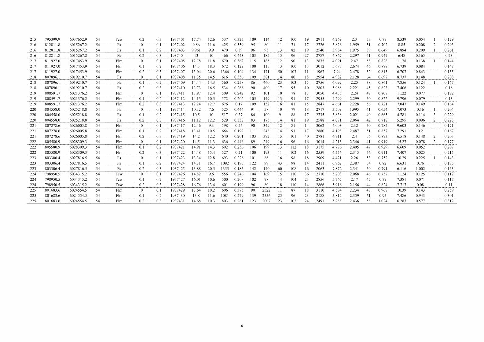
6
215 795399.9 6037652.9 54 Fcw 0.2 0.3 1937401 17.74 12.6 537 0.325 109 114 12 100 19 2911 4.269 2.3 53 0.79 8.539 0.054 1 0.129 216 812811.8 6015267.2 54 Fs 0 0.1 1937402 9.86 11.6 425 0.559 95 80 11 71 17 2726 3.826 1.959 51 0.702 8.85 0.208 2 0.293 216 812811.8 6015267.2 54 Fs 0.1 0.2 1937403 9.961 9.9 470 0.39 96 95 13 82 19 2540 3.934 1.975 39 0.649 6.894 0.209 1 0.261 216 812811.8 6015267.2 54 Fs 0.2 0.3 1937404 13 10 466 0.443 103 182 15 96 27 2787 4.867 2.297 41 0.947 6.48 0.165 0.23 217 811927.0 6017453.9 54 Flm 0 0.1 1937405 12.78 11.8 670 0.362 115 185 12 90 13 2875 4.091 2.47 58 0.828 11.78 0.138 1 0.144 217 811927.0 6017453.9 54 Flm 0.1 0.2 1937406 14.3 18.3 672 0.129 100 115 13 100 13 3012 5.683 2.674 46 0.899 6.739 0.084 0.147 217 811927.0 6017453.9 54 Flm 0.2 0.3 1937407 13.04 20.6 1366 0.104 134 171 50 107 11 1967 7.94 2.478 52 0.815 6.707 0.843 0.155 218 807896.1 6019210.7 54 Fs 0 0.1 1937408 11.35 14.5 616 0.356 109 381 14 80 18 2954 4.982 2.128 64 0.697 8.737 0.148 0.208 218 807896.1 6019210.7 54 Fs 0.1 0.2 1937409 14.44 14.3 560 0.258 86 460 23 103 15 2756 6.092 2.25 38 0.861 7.856 0.124 1 0.167 218 807896.1 6019210.7 54 Fs 0.2 0.3 1937410 13.73 16.5 534 0.266 90 400 17 95 10 2803 5.988 2.221 45 0.823 7.406 0.122 0.18 219 808591.7 6021376.2 54 Flm 0 0.1 1937411 13.97 12.4 509 0.242 92 101 10 78 13 3050 4.455 2.24 47 0.807 11.22 0.077 0.172 219 808591.7 6021376.2 54 Flm 0.1 0.2 1937412 14.15 10.5 572 0.202 105 149 13 91 17 2955 4.299 2.299 50 0.822 9.796 0.079 0.13 219 808591.7 6021376.2 54 Flm 0.2 0.3 1937413 12.24 12.7 676 0.17 109 152 16 81 15 2847 4.661 2.228 56 0.721 7.047 0.149 0.164 220 804558.0 6025218.8 54 Fs 0 0.1 1937414 10.32 7.6 525 0.444 91 58 10 79 18 2717 3.509 1.995 41 0.654 7.073 0.16 1 0.204 220 804558.0 6025218.8 54 Fs 0.1 0.2 1937415 10.5 10 517 0.37 84 100 9 88 17 2735 3.838 2.021 40 0.665 4.781 0.114 3 0.229 220 804558.0 6025218.8 54 Fs 0.2 0.3 1937416 11.12 12.2 529 0.338 83 175 14 81 19 2588 4.071 2.064 42 0.718 5.295 0.096 2 0.223 221 807278.6 6026005.8 54 Flm 0 0.1 1937417 12.46 9.3 598 0.24 90 349 12 81 14 3062 4.003 2.32 50 0.782 9.603 0.146 0.171 221 807278.6 6026005.8 54 Flm 0.1 0.2 1937418 13.41 10.5 664 0.192 111 248 14 91 17 2880 4.198 2.487 51 0.857 7.291 0.2 0.167 221 807278.6 6026005.8 54 Flm 0.2 0.3 1937419 14.2 12.2 640 0.201 103 392 15 101 40 2781 4.711 2.4 56 0.893 6.518 0.148 2 0.203 222 805580.9 6028309.3 54 Flm 0 0.1 1937420 14.5 11.3 636 0.446 89 249 16 96 16 3014 4.215 2.346 41 0.919 15.27 0.078 2 0.177 222 805580.9 6028309.3 54 Flm 0.1 0.2 1937421 14.91 14.3 602 0.236 106 199 13 112 18 3175 4.776 2.405 47 0.929 6.609 0.052 0.207 222 805580.9 6028309.3 54 Flm 0.2 0.3 1937422 14.48 15.4 527 0.21 100 193 11 102 16 2559 4.556 2.315 56 0.911 7.407 0.025 0.215 223 803306.4 6027816.5 54 Fs 0 0.1 1937423 13.34 12.8 693 0.226 101 86 16 98 18 2909 4.421 2.26 53 0.752 10.29 0.225 1 0.143 223 803306.4 6027816.5 54 Fs 0.1 0.2 1937424 14.31 16.7 1092 0.195 122 99 43 98 14 2411 6.962 2.387 54 0.82 6.631 0.76 0.175 223 803306.4 6027816.5 54 Fs 0.2 0.3 1937425 13.88 20.5 1355 0.185 142 140 60 108 16 2063 7.872 2.341 50 0.791 6.116 1.002 0.163 224 798950.5 6034315.2 54 Fcw 0 0.1 1937426 14.82 9.6 556 0.246 104 169 15 110 36 2710 5.208 2.068 46 0.757 11.24 0.125 0.112 224 798950.5 6034315.2 54 Fcw 0.1 0.2 1937427 16.01 10.6 500 0.208 102 98 14 104 23 2856 5.767 2.17 47 0.79 7.381 0.071 0.117 224 798950.5 6034315.2 54 Fcw 0.2 0.3 1937428 16.76 13.4 601 0.199 96 80 18 110 14 2866 5.916 2.156 44 0.824 7.717 0.08 0.11 225 801683.6 6024554.5 54 Flm 0 0.1 1937429 13.64 10.2 606 0.375 90 2522 11 87 18 3110 4.584 2.234 48 0.968 10.39 0.143 0.259 225 801683.6 6024554.5 54 Flm 0.1 0.2 1937430 13.8 11.6 1081 0.279 139 2556 25 96 23 2188 5.812 2.359 61 0.95 7.486 0.943 0.301 225 801683.6 6024554.5 54 Flm 0.2 0.3 1937431 14.68 10.3 803 0.281 123 2007 23 102 24 2491 5.288 2.436 58 1.024 6.287 0.577 0.312

7
Site No. Easting Northing Zone Geomorphic
Unit
Top Depth
(m)
Base Depth
(m)
Sample ID
Nb ppm
Nd ppm
Ni ppm
P2O5 %
Pb ppm
Rb ppm
S ppm
Sc ppm
SiO2 %
Sr ppm
Th ppm
TiO2 %
U ppm
V ppm
W ppm
Y ppm
Zn ppm
Zr ppm
201 760201.0 6075682.0 54 Fs 0 0.1 1937357 15 36 15 0.075 21 137.2 239 15 70.3 68.9 13 0.714 2.2 77 12 39 74 289 201 760201.0 6075682.0 54 Fs 0.1 0.2 1937358 15 25 20 0.075 33 144.5 216 18 68.42 65.1 28 0.734 5.3 85 6 39 73 265 201 760201.0 6075682.0 54 Fs 0.2 0.3 1937359 15 42 14 0.062 33 138.9 163 14 71.06 63.1 9 0.733 2.8 77 8 35 69 294 202 760739.0 6070574.0 54 Fs 0 0.1 1937360 18 41 12 0.068 30 133.7 256 14 73.69 57.4 19 0.767 7.9 82 4 41 59 361 202 760739.0 6070574.0 54 Fs 0.1 0.2 1937361 18 44 10 0.066 26 131.9 221 8 73.92 53.2 19 0.788 4.9 83 43 60 361 202 760739.0 6070574.0 54 Fs 0.2 0.3 1937362 17 45 19 0.052 28 138.5 134 17 73.6 50 22 0.817 3.9 86 8 43 59 339 203 768079.0 6066831.0 54 Fs 0 0.1 1937363 17 44 15 0.082 38 161.8 232 9 67.92 61.2 21 0.699 8.6 88 9 39 68 284 203 768079.0 6066831.0 54 Fs 0.1 0.2 1937364 16 39 23 0.074 36 165 191 8 68.96 61.4 27 0.722 2.7 91 6 44 71 265 203 768079.0 6066831.0 54 Fs 0.2 0.3 1937365 18 41 16 0.081 35 161.3 161 17 70.31 62 34 0.74 6.5 92 2 42 61 317 204 767619.0 6063545.0 54 Fs 0 0.1 1937366 19 28 10 0.063 36 145 248 10 70.96 56.2 40 0.693 10 79 5 38 66 346 204 767619.0 6063545.0 54 Fs 0.1 0.2 1937367 19 32 14 0.054 34 147.2 153 16 71.43 60.7 25 0.721 4.2 88 7 38 64 332 204 767619.0 6063545.0 54 Fs 0.2 0.3 1937368 17 42 16 0.053 33 148.3 140 10 70.49 60 33 0.707 5.9 87 7 39 59 343 205 765768.0 6058599.0 54 Fs 0 0.1 1937369 20 44 22 0.07 33 131.9 266 9 71.58 64.9 27 0.858 4.3 89 10 48 74 333 205 765768.0 6058599.0 54 Fs 0.1 0.2 1937370 19 42 21 0.058 33 151 211 17 67.52 65.4 22 0.862 4.9 105 14 43 71 287 205 765768.0 6058599.0 54 Fs 0.2 0.3 1937371 19 41 30 0.055 37 155.3 221 18 68.07 68.3 31 0.877 6.6 108 14 45 72 284 206 784958.9 6050503.1 54 Fcw 0 0.1 1937372 19 35 10 0.091 38 150.8 391 13 66.23 58.1 37 0.778 10.5 84 15 37 66 274 206 784958.9 6050503.1 54 Fcw 0.1 0.2 1937373 18 36 10 0.07 32 156.4 125 12 72.11 50.5 23 0.858 6 91 14 42 66 285 206 784958.9 6050503.1 54 Fcw 0.2 0.3 1937374 17 38 13 0.087 28 153 150 15 70.63 50.9 26 0.84 11.8 91 14 44 63 285 207 787867.9 6045998.2 54 Fcw 0 0.1 1937375 18 29 8 0.058 31 118.3 172 9 77.74 46.3 39 0.707 4.4 64 4 36 41 350 207 787867.9 6045998.2 54 Fcw 0.1 0.2 1937376 20 27 7 0.045 32 122.9 129 19 77.34 46.5 27 0.725 7.2 71 17 37 41 348 207 787867.9 6045998.2 54 Fcw 0.2 0.3 1937377 16 33 5 0.044 34 119.4 121 16 78.86 45.8 19 0.737 9.8 70 9 39 43 350 208 787684.1 6040035.0 54 Flm 0 0.1 1937378 21 50 22 0.269 34 137.3 269 12 68.94 88.9 30 0.899 5.6 91 6 45 74 278 208 787684.1 6040035.0 54 Flm 0.1 0.2 1937379 20 55 39 0.176 35 188.4 196 12 66.36 79.4 43 0.915 5.3 112 9 42 67 243 208 787684.1 6040035.0 54 Flm 0.2 0.3 1937380 20 45 37 0.178 30 201.3 212 19 63.29 83.5 38 0.87 6.2 119 6 42 77 222 209 789875.5 6040784.6 54 Flm 0 0.1 1937381 18 38 17 0.072 37 124.4 235 9 74.49 66.5 20 0.758 12.4 61 19 41 57 368 209 789875.5 6040784.6 54 Flm 0.1 0.2 1937382 18 34 23 0.064 24 140.9 142 15 73.6 65.6 30 0.811 12.9 80 9 41 55 360 209 789875.5 6040784.6 54 Flm 0.2 0.3 1937383 21 49 20 0.066 28 147.6 115 19 72.42 61.4 27 0.796 1.4 82 10 40 58 360 210 790509.1 6042751.0 54 Flm 0 0.1 1937384 19 40 15 0.11 35 177 241 14 65.34 59.5 39 0.789 10.2 97 44 70 280 210 790509.1 6042751.0 54 Flm 0.1 0.2 1937385 17 35 19 0.115 36 169.6 156 15 67.6 57.7 18 0.82 7.1 101 21 45 67 287 210 790509.1 6042751.0 54 Flm 0.2 0.3 1937386 19 51 14 0.095 33 175.8 138 10 67.86 57.5 43 0.817 9.3 102 9 47 66 306 211 791440.8 6041438.2 54 Fcw 0 0.1 1937387 16 66 10 0.215 40 168.3 258 18 60.34 54.8 14 0.782 2.7 115 12 42 77 231 211 791440.8 6041438.2 54 Fcw 0.1 0.2 1937388 18 53 12 0.165 40 178.5 174 19 62.07 53.7 33 0.813 9.6 117 7 39 79 225 211 791440.8 6041438.2 54 Fcw 0.2 0.3 1937389 19 38 19 0.155 37 182.1 171 21 63.05 55.1 34 0.833 11.4 121 8 39 75 226 212 791018.1 6045368.5 54 Fl 0 0.1 1937390 15 40 8 0.136 28 116.8 549 7 67.46 79.8 16 0.715 5.9 58 37 68 334 212 791018.1 6045368.5 54 Fl 0.1 0.2 1937391 23 34 5 0.097 33 143 148 13 78.17 59.6 43 0.881 9 70 5 42 38 380 212 791018.1 6045368.5 54 Fl 0.2 0.3 1937392 24 39 0.068 32 123.2 132 14 79.79 52.8 25 0.844 8.6 67 13 44 34 436 213 785302.6 6039372.3 54 Fl 0 0.1 1937393 16 29 12 0.171 30 144.8 417 14 62.91 90.8 3 0.78 4.3 81 6 44 77 254 213 785302.6 6039372.3 54 Fl 0.1 0.2 1937394 23 39 18 0.146 30 158.9 171 12 70.54 61.8 32 0.882 8 96 42 58 308 213 785302.6 6039372.3 54 Fl 0.2 0.3 1937395 19 45 15 0.097 33 156.8 211 14 71.17 59.8 29 0.882 7.8 94 10 40 56 320 214 793798.1 6041114.4 54 Fl 0 0.1 1937396 16 27 8 0.204 32 110.7 427 11 65.18 102 19 0.7 5.3 57 12 38 61 345 214 793798.1 6041114.4 54 Fl 0.1 0.2 1937397 20 30 6 0.084 26 122 148 3 80.27 50.1 21 0.809 6.8 67 19 40 37 460 214 793798.1 6041114.4 54 Fl 0.2 0.3 1937398 20 31 19 0.062 24 140.2 132 22 75.72 51.2 22 0.883 3.3 82 2 42 48 373 215 795399.9 6037652.9 54 Fcw 0 0.1 1937399 17 43 23 0.109 39 183.5 516 13 63.6 57.9 32 0.786 3 111 17 40 100 254 215 795399.9 6037652.9 54 Fcw 0.1 0.2 1937400 14 44 20 0.105 40 190.3 255 23 63.65 53.9 23 0.786 126 13 41 105 244 215 795399.9 6037652.9 54 Fcw 0.2 0.3 1937401 15 47 24 0.092 34 182.4 209 12 64.52 56 17 0.751 2.6 126 20 41 100 241
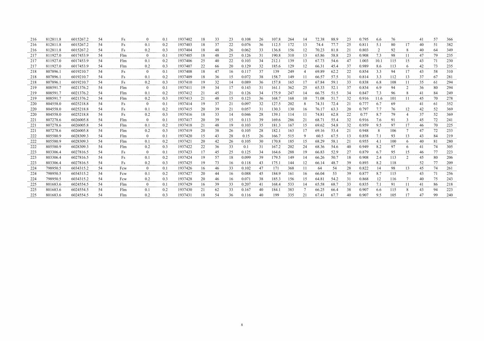
8
216 812811.8 6015267.2 54 Fs 0 0.1 1937402 18 33 23 0.108 26 107.8 264 14 72.38 88.9 23 0.795 6.6 76 41 57 366 216 812811.8 6015267.2 54 Fs 0.1 0.2 1937403 18 37 22 0.076 36 112.5 172 13 74.4 77.7 25 0.811 5.1 80 17 40 51 382 216 812811.8 6015267.2 54 Fs 0.2 0.3 1937404 18 48 26 0.062 33 136.8 156 12 70.23 81.8 21 0.803 2 92 8 40 64 349 217 811927.0 6017453.9 54 Flm 0 0.1 1937405 18 48 25 0.126 31 190.8 310 13 65.86 58.8 23 0.908 7.3 98 11 47 79 235 217 811927.0 6017453.9 54 Flm 0.1 0.2 1937406 25 40 22 0.103 34 212.1 139 13 67.73 54.6 47 1.003 10.1 115 15 43 71 230 217 811927.0 6017453.9 54 Flm 0.2 0.3 1937407 22 66 20 0.129 32 185.6 129 12 66.31 45.4 37 0.989 8.6 113 6 42 73 235 218 807896.1 6019210.7 54 Fs 0 0.1 1937408 18 47 16 0.117 37 139 249 4 69.89 62.2 22 0.854 3.3 94 17 43 58 310 218 807896.1 6019210.7 54 Fs 0.1 0.2 1937409 18 36 15 0.072 38 158.7 149 11 66.57 57.5 31 0.814 3.3 112 13 37 67 281 218 807896.1 6019210.7 54 Fs 0.2 0.3 1937410 19 32 14 0.089 36 157.8 165 17 67.84 59.1 33 0.838 6.8 108 11 35 61 294 219 808591.7 6021376.2 54 Flm 0 0.1 1937411 19 34 17 0.143 31 161.1 362 25 65.33 52.1 37 0.834 6.9 94 2 36 80 294 219 808591.7 6021376.2 54 Flm 0.1 0.2 1937412 21 45 21 0.126 34 175.9 247 14 66.75 51.5 34 0.847 7.3 96 8 41 84 249 219 808591.7 6021376.2 54 Flm 0.2 0.3 1937413 21 48 15 0.123 36 168.7 168 10 71.08 51.7 32 0.916 11.6 101 11 45 70 278 220 804558.0 6025218.8 54 Fs 0 0.1 1937414 19 37 21 0.097 32 127.5 202 8 74.31 72.4 21 0.777 6.7 69 41 61 352 220 804558.0 6025218.8 54 Fs 0.1 0.2 1937415 20 39 21 0.057 31 130.3 130 16 76.17 63.3 20 0.797 7.7 76 12 42 52 369 220 804558.0 6025218.8 54 Fs 0.2 0.3 1937416 18 33 14 0.046 28 139.1 114 11 74.81 62.8 22 0.77 8.7 79 4 37 52 369 221 807278.6 6026005.8 54 Flm 0 0.1 1937417 20 39 15 0.113 39 169.6 286 21 68.71 55.4 32 0.916 7.6 91 3 45 72 241 221 807278.6 6026005.8 54 Flm 0.1 0.2 1937418 21 48 19 0.103 35 181.3 167 15 69.62 54.8 32 0.959 9.5 97 17 46 70 225 221 807278.6 6026005.8 54 Flm 0.2 0.3 1937419 20 38 26 0.105 28 182.1 163 17 69.16 53.4 21 0.948 8 106 7 47 72 233 222 805580.9 6028309.3 54 Flm 0 0.1 1937420 15 43 28 0.15 26 166.7 515 9 60.5 67.5 13 0.858 7.1 93 13 43 84 219 222 805580.9 6028309.3 54 Flm 0.1 0.2 1937421 20 42 26 0.105 30 170.8 185 15 68.29 58.1 21 0.955 4.1 100 6 40 81 280 222 805580.9 6028309.3 54 Flm 0.2 0.3 1937422 22 36 33 0.1 31 167.2 202 24 68.36 54.6 40 0.949 8.2 97 6 41 74 305 223 803306.4 6027816.5 54 Fs 0 0.1 1937423 17 45 25 0.125 34 164.6 288 19 66.83 52.9 27 0.879 6.7 95 15 46 77 223 223 803306.4 6027816.5 54 Fs 0.1 0.2 1937424 19 57 18 0.099 39 179.5 149 14 66.26 50.7 18 0.908 2.4 113 2 45 80 206 223 803306.4 6027816.5 54 Fs 0.2 0.3 1937425 19 73 16 0.118 43 175.1 144 12 66.14 48.7 39 0.893 8.2 118 52 77 209 224 798950.5 6034315.2 54 Fcw 0 0.1 1937426 16 46 33 0.102 47 171 368 11 64 54 28 0.822 14 98 13 45 74 261 224 798950.5 6034315.2 54 Fcw 0.1 0.2 1937427 20 44 16 0.088 45 184.9 161 16 66.04 53 39 0.877 8.7 115 43 71 256 224 798950.5 6034315.2 54 Fcw 0.2 0.3 1937428 20 46 16 0.071 38 185.3 156 15 64.81 54.2 31 0.868 12 116 7 40 75 243 225 801683.6 6024554.5 54 Flm 0 0.1 1937429 16 39 33 0.207 41 168.4 533 14 65.58 68.7 33 0.835 7.1 91 11 41 86 218 225 801683.6 6024554.5 54 Flm 0.1 0.2 1937430 21 62 33 0.167 40 184.1 383 7 66.25 66.4 38 0.907 6.6 115 8 43 94 223 225 801683.6 6024554.5 54 Flm 0.2 0.3 1937431 18 54 36 0.116 40 199 335 21 67.41 67.7 40 0.907 9.5 105 17 47 99 240

9
Appendix 6.4: Barr Creek Gunbower XRD results
Site No. Depth Sample # Minerals Identified Weight
% Site No. Depth Sample # Minerals Identified Weight
% Site No. Depth Sample # Minerals Identified Weight %
201 0-10 1937357 Quartz 58.2 203 0-10 1937363 Quartz 53.5 205 0-10 1937369 Quartz 61.7 Kaolin 22.7 Kaolin 24.9 Kaolin 19 Muscovite 13.1 Muscovite 16 Muscovite 12.8 Albite 4.2 Albite 3 Albite 3.6 Microcline 1.8 Orthoclase 2.6 Orthoclase 2.8 100 100 99.9
201 10-20 1937358 Quartz 55.6 203 10-20 1937364 Quartz 59.1 205 10-20 1937370 Quartz 61.9 Kaolin 24.3 Kaolin 16 Muscovite 16.6 Muscovite 13.5 Muscovite 15.2 Kaolin 14.1 Albite 3.7 Albite 5 Orthoclase 3.9 Microcline 2.9 Orthoclase 4.7 Albite 3.5 100 100 100
201 20-30 1937359 Quartz 59.6 203 20-30 1937365 Quartz 58.8 205 20-30 1937371 Quartz 60.8 Kaolin 19 Kaolin 20.1 Muscovite 17.5 Muscovite 11.4 Muscovite 13.5 Kaolin 14.7 Microcline 5.6 Albite 4 Orthoclase 3.7 Albite 4.4 Orthoclase 3.6 Albite 3.3 100 100 100
202 0-10 1937360 Quartz 66.8 204 0-10 1937366 Quartz 61.9 206 0-10 1937372 Quartz 58.5 Kaolin 16.2 Kaolin 20.5 Kaolin 22.9 Muscovite 10.5 Muscovite 11.1 Muscovite 13.9 Albite 3.7 Albite 3.8 Albite 2.5 Orthoclase 2.8 Orthoclase 2.7 Orthoclase 2.2 100 100 100
202 10-20 1937361 Quartz 65.3 204 10-20 1937367 Quartz 57.5 206 10-20 1937373 Quartz 60.6 Kaolin 16.8 Kaolin 21.8 Kaolin 20.3 Muscovite 7.8 Muscovite 12.7 Muscovite 14 Illite 1 4.4 Albite 4.2 Orthoclase 2.7 Albite 3.3 Orthoclase 3.9 Albite 2.5 Orthoclase 2.3 100.1 100.1 99.9 204 20-30 1937368 Quartz 60.1 206 20-30 1937374 Quartz 60.9
202 20-30 1937362 Quartz 65.8 Kaolin 19.9 Kaolin 20.7 Kaolin 16.5 Muscovite 12 Muscovite 13.6 Muscovite 11.8 Albite 4.3 Albite 2.6 Albite 3.2 Orthoclase 3.6 Orthoclase 2.3 Orthoclase 2.8 99.9 100.1 100.1

10
Site No. Depth Sample # Minerals Identified Weight
% Site No. Depth Sample # Minerals Identified Weight
% Site No. Depth Sample # Minerals Identified Weight %
207 0-10 1937375 Quartz 71.8 208 20-30 1937380 Quartz 50.2 210 20-30 1937386 Quartz 54.4 Muscovite 7.2 Kaolin 24.9 Kaolin 24.4 Kaolin 14.6 Muscovite 19.5 Muscovite 15.1 Anorthite 4.8 Orthoclase 2.9 Albite 3.3 Orthoclase 1.7 Albite 2 Orthoclase 2.7 100.1 Montmorillonite, (CP) 0.5 99.9 100
207 10-20 1937376 Quartz 72.7 211 0-10 1937387 Quartz 48.6 Kaolin 14 209 0-10 1937381 Quartz 67.2 Muscovite 18.8 Muscovite 7.1 Kaolin 15.5 Kaolin 28.6 Albite 3.5 Muscovite 9.7 Anorthite 2.8 Orthoclase 2.8 Albite 4.1 Orthoclase 1 1.3 100.1 Orthoclase 3.5 100.1 100
207 20-30 1937377 Quartz 70.1 211 20-30 1937389 Quartz 48.1 Kaolin 14.5 209 10-20 1937382 Quartz 67.5 Kaolin 27.2 Muscovite 8.4 Kaolin 15.1 Muscovite 18.5 Albite 3.8 Muscovite 11.4 Orthoclase 3.1 Orthoclase 3.2 Orthoclase 3.1 Albite 3.1 100 Albite 2.9 100 100
208 0-10 1937378 Quartz 66.4 212 0-10 1937390 Quartz 68.4 Kaolin 16.2 209 20-30 1937383 Quartz 63.5 Kaolin 16.9 Muscovite 10.6 Kaolin 16.8 Muscovite 8.2 Orthoclase 3.5 Muscovite 12.5 Albite 3.8 Albite 3.3 Albite 4 Orthoclase 2.7 100 Orthoclase 3.3 100 100.1
208 10-20 1937379 Quartz 57.2 212 10-20 1937391 Quartz 70.3 Kaolin 19.9 210 0-10 1937384 Quartz 54.6 Kaolin 14.4 Muscovite 17.4 Muscovite 15.7 Muscovite 8 Orthoclase 2.9 Kaolin 23.1 Albite 4.4 Albite 2.6 Anorthite 4.6 Orthoclase 2.9 100 Orthoclase 1 2 100 100
211 10-20 1937388 Quartz 48.7 212 20-30 1937392 Quartz 73.6 Kaolin 29.4 210 10-20 1937385 Quartz 55.7 Kaolin 12.2 Muscovite 17.4 Kaolin 24.2 Muscovite 6.5 Anorthite 2.6 Muscovite 14.4 Albite 4.7 Orthoclase 2 Orthoclase 3 Orthoclase 3 100.1 Albite 2.6 100 99.9

11
Site No. Depth Sample # Minerals Identified Weight
% Site No. Depth Sample # Minerals Identified Weight
% Site No. Depth Sample # Minerals Identified Weight %
213 0-10 1937393 Quartz 59.3 215 0-10 1937399 Quartz 45.9 217 0-10 1937405 Quartz 57.3 Kaolin 21.2 Muscovite 19.9 Kaolin 22.3 Muscovite 13.8 Kaolin 30.1 Muscovite 16.2 Albite 3.1 Anorthite 2.5 Albite 2.1 Orthoclase 2.5 Orthoclase 1.6 Orthoclase 2 99.9 100 99.9
213 10-20 1937394 Quartz 64.6 215 10-20 1937400 Quartz 41 217 10-20 1937406 Quartz 55.8 Kaolin 16.8 Muscovite 21.1 Kaolin 22.8 Muscovite 12.9 Kaolin 33.1 Muscovite 16.2 Albite 2.9 Anorthite 3.3 Orthoclase 2.8 Orthoclase 2.8 Orthoclase 1.4 Albite 2.5 100 99.9 100.1
213 20-30 1937395 Quartz 62.4 215 20-30 1937401 Quartz 45.3 217 20-30 1937407 Quartz 58.8 Kaolin 19 Muscovite 20.3 Kaolin 21.7 Muscovite 12.2 Kaolin 30.7 Muscovite 14.7 Albite 3.3 Anorthite 1.8 Orthoclase 2.7 Orthoclase 3.1 Orthoclase 1.9 Albite 2.2 100 100 100.1
214 0-10 1937396 Quartz 66.5 216 0-10 1937402 Quartz 69.2 218 0-10 1937408 Quartz 63.2 Kaolin 18.6 Kaolin 16.1 Muscovite 12.2 Muscovite 8.1 Muscovite 7.3 Kaolin 18.1 Albite 4 Albite 4.1 Anorthite 4.8 Orthoclase 2.7 Orthoclase 3.4 Orthoclase 1.8 99.9 100.1 100.1
214 10-20 1937397 Quartz 73 216 10-20 1937403 Quartz 71.3 218 10-20 1937409 Quartz 55.3 Kaolin 12.7 Kaolin 14 Kaolin 25.2 Muscovite 6.9 Muscovite 7.2 Muscovite 14.7 Albite 4.5 Albite 4.2 Orthoclase 2.6 Orthoclase 3 Orthoclase 3.2 Albite 2.2 100.1 99.9 100
214 20-30 1937398 Quartz 67.6 Kaolin 15.5 216 20-30 1937404 Quartz 62 218 20-30 1937410 Quartz 59.5 Muscovite 10.2 Kaolin 19.9 Kaolin 21.1 Albite 3.7 Muscovite 10.9 Muscovite 13.8 Orthoclase 2.9 Albite 3.7 Orthoclase 3 99.9 Orthoclase 3.5 Albite 2.6 100 100
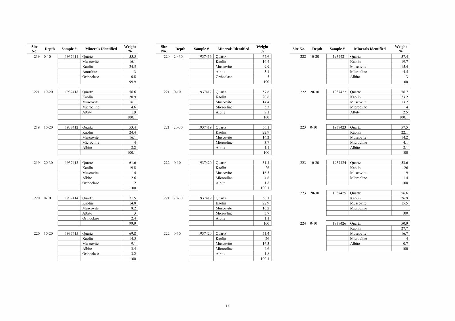
12
Site No. Depth Sample # Minerals Identified Weight
% Site No. Depth Sample # Minerals Identified Weight
% Site No. Depth Sample # Minerals Identified Weight %
219 0-10 1937411 Quartz 55.5 220 20-30 1937416 Quartz 67.6 222 10-20 1937421 Quartz 57.4 Muscovite 16.1 Kaolin 16.4 Kaolin 19.7 Kaolin 24.5 Muscovite 9.9 Muscovite 15.4 Anorthite 3 Albite 3.1 Microcline 4.5 Orthoclase 0.8 Orthoclase 3 Albite 3 99.9 100 100
221 10-20 1937418 Quartz 56.6 221 0-10 1937417 Quartz 57.6 222 20-30 1937422 Quartz 56.7 Kaolin 20.9 Kaolin 20.6 Kaolin 23.2 Muscovite 16.1 Muscovite 14.4 Muscovite 13.7 Microcline 4.6 Microcline 5.3 Microcline 4 Albite 1.9 Albite 2.1 Albite 2.5 100.1 100 100.1
219 10-20 1937412 Quartz 53.4 221 20-30 1937419 Quartz 56.1 223 0-10 1937423 Quartz 57.5 Kaolin 24.4 Kaolin 22.9 Kaolin 22.1 Muscovite 16.1 Muscovite 16.2 Muscovite 14.2 Microcline 4 Microcline 3.7 Microcline 4.1 Albite 2.2 Albite 1.1 Albite 2.1 100.1 100 100
219 20-30 1937413 Quartz 61.6 222 0-10 1937420 Quartz 51.4 223 10-20 1937424 Quartz 53.6 Kaolin 19.8 Kaolin 26 Kaolin 26 Muscovite 14 Muscovite 16.3 Muscovite 19 Albite 2.6 Microcline 4.6 Microcline 1.4 Orthoclase 2 Albite 1.8 100 100 100.1 223 20-30 1937425 Quartz 56.6
220 0-10 1937414 Quartz 71.5 221 20-30 1937419 Quartz 56.1 Kaolin 26.9 Kaolin 14.8 Kaolin 22.9 Muscovite 15.5 Muscovite 8.2 Muscovite 16.2 Microcline 1 Albite 3 Microcline 3.7 100 Orthoclase 2.4 Albite 1.1 99.9 100 224 0-10 1937426 Quartz 50.9 Kaolin 27.7
220 10-20 1937415 Quartz 69.8 222 0-10 1937420 Quartz 51.4 Muscovite 16.7 Kaolin 14.5 Kaolin 26 Microcline 4 Muscovite 9.1 Muscovite 16.3 Albite 0.7 Albite 3.4 Microcline 4.6 100 Orthoclase 3.2 Albite 1.8 100 100.1
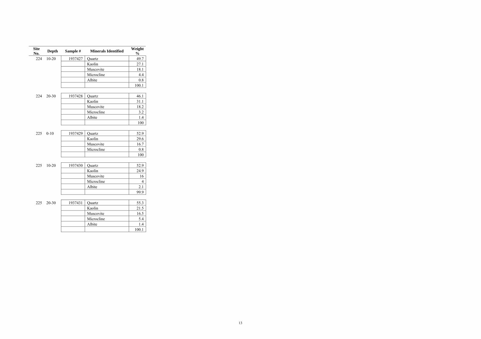
13
Site No. Depth Sample # Minerals Identified Weight
% 224 10-20 1937427 Quartz 49.7
Kaolin 27.1 Muscovite 18.1 Microcline 4.4 Albite 0.8 100.1
224 20-30 1937428 Quartz 46.1 Kaolin 31.1 Muscovite 18.2 Microcline 3.2 Albite 1.4 100
225 0-10 1937429 Quartz 52.9 Kaolin 29.6 Muscovite 16.7 Microcline 0.8 100
225 10-20 1937430 Quartz 52.9 Kaolin 24.9 Muscovite 16 Microcline 4 Albite 2.1 99.9
225 20-30 1937431 Quartz 55.3 Kaolin 21.5 Muscovite 16.5 Microcline 5.4 Albite 1.4 100.1