geophysical survey logistical report · geophysical survey logistical report ... * coordinate...
TRANSCRIPT
42A05NE2018 2.19330 BRISTOL 010
Quantec IP Inc. P.O Box 580, 101 King Street Porcupine, ON PON 1CO Phone (705).235.2166 Fax (705) 235 2255
Geophysical Survey Logistical Report
Regarding theGRADIENT-REALSECTION TDmRESISIWITY SURVEY over the BRISTOL PROPERTY, Bristol Twp., ON, on behalf ofPROSPECTORS ALLIANCE CORP., Toronto, ON
C '•5
P188 PROSPECTORS ALLIANCE CORP. Bristol RSIP
42A05NE2018 2.19330 BRISTOL 010C
1. INTRODUCTION.........................................................................................................................................3
2. GENERAL SURVEY DETAILS..................................................................................................................^
2.1 LOCATION..................................................................................................................................^2.2 ACCESS.....................................................................................................................................52.3 SURVEY GRID................................................................................................... .........................5
3. SURVEY WORK UNDERTAKEN..............................................................................................................^
3.1 GENERALITIES...........................................................................................................................^3.2 PERSONNEL ...............................................................................................................................63.3 SPECIFICATIONS..........................................................................................................................63.4 SURVEY COVERAGE....................................................................................................................?3.5 INSTRUMENTATION.....................................................................................................................^3.6 PARAMETERS .............................................................................................................................83.7 MEASUREMENT ACCURACY AND REPEATABILITY.................................................. ........................93.8 DATA PRESENTATION.................................................................................................................^
APPENDIX A: STATEMENT OF QUALIFICATIONS APPENDIX B: THEORETICAL BASIS APPENDIX C: PRODUCTION SUMMARY APPENDIX D: INSTRUMENT SPECIFICATIONS: APPENDIX E: IP 6 DUMP FILE FORMAT APPENDIX F: OPERATOR COMMENTS APPENDIX G: LIST OF MAPS APPENDIX H: PLAN MAPS AND SECTION
Figure 1: General Survey Location of the Bristol Twp. Project.......................................................4Figure 2: Gradient Array Layout..................................................................................................../Table l: Reconnaissance Survey Coverage at Bristol Twp. Property............................................7Table II: Realsection (Detail) Survey Coverage.............................................................................8Table III: Decay Curve Sampling....................................................................................................8
P188 PROSPECTORS ALLIANCE CORP. Bristol RSIP
* QIP Project No:
* Project Name:
* General Location:
* Survey Period:
* Survey Type:
* Client:
* Client Address:
* Client Representative:
* Objectives:
P188
Bristol Twp. Property
Timmins, ON
May 22ND to 28 , 1997
Time Domain Induced Polarization.
Prospectors Alliance Corp.
95 Wellington St West, Suite 1800 Toronto, ON M5J 2N7
Peter Vamos, John Harvey
1. Exploration objectives: To locate and delineate potential zones of sulphide mineralization associated with precious metals, hosted in sub-vertical shear structures, for the purposes of drill targeting and to provide information regarding the depth of overburden
2. Geophysical objectives: To identify potential drill targets by measurement of their IP and Resistivity physical properties. The gradient and Realsection tech niques were chosen based on their high resolution and deep penetration char acteristics.
Report Type: Logistical
P188 PROSPECTORS ALLIANCE CORP. Bristol RS1P
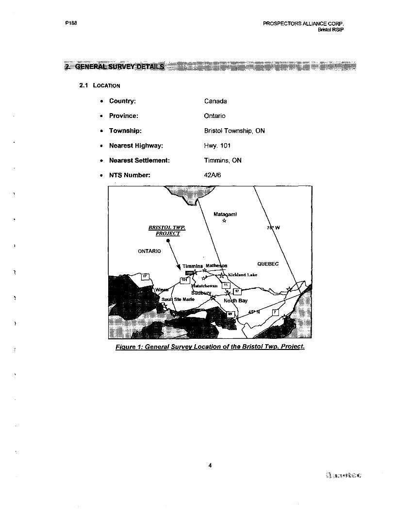
2.1 LOCATION
* Country:
* Province:
* Township:
* Nearest Highway:
* Nearest Settlement:
* NTS Number:
Canada
Ontario
Bristol Township, ON
Hwy. 101
Timmins, ON
42A/6
Figure 1: General Survey Location of the Bristol Twp. Project.
P188 PROSPECTORS ALLIANCE CORP. Bristol RSIP
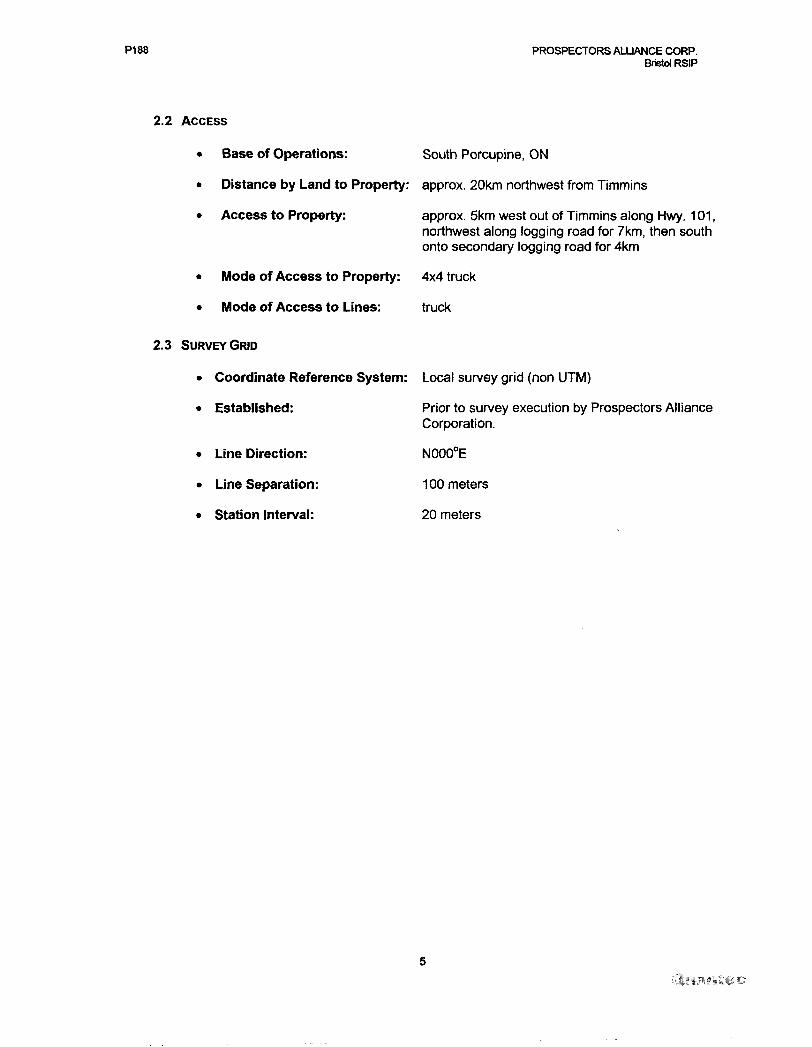
2.2 ACCESS
* Base of Operations: South Porcupine, ON
* Distance by Land to Property: approx. 20km northwest from Timmins
Access to Property: approx. 5km west out of Timmins along Hwy. 101, northwest along logging road for 7km, then south onto secondary logging road for 4km
* Mode of Access to Property: 4x4 truck
* Mode of Access to Lines: truck
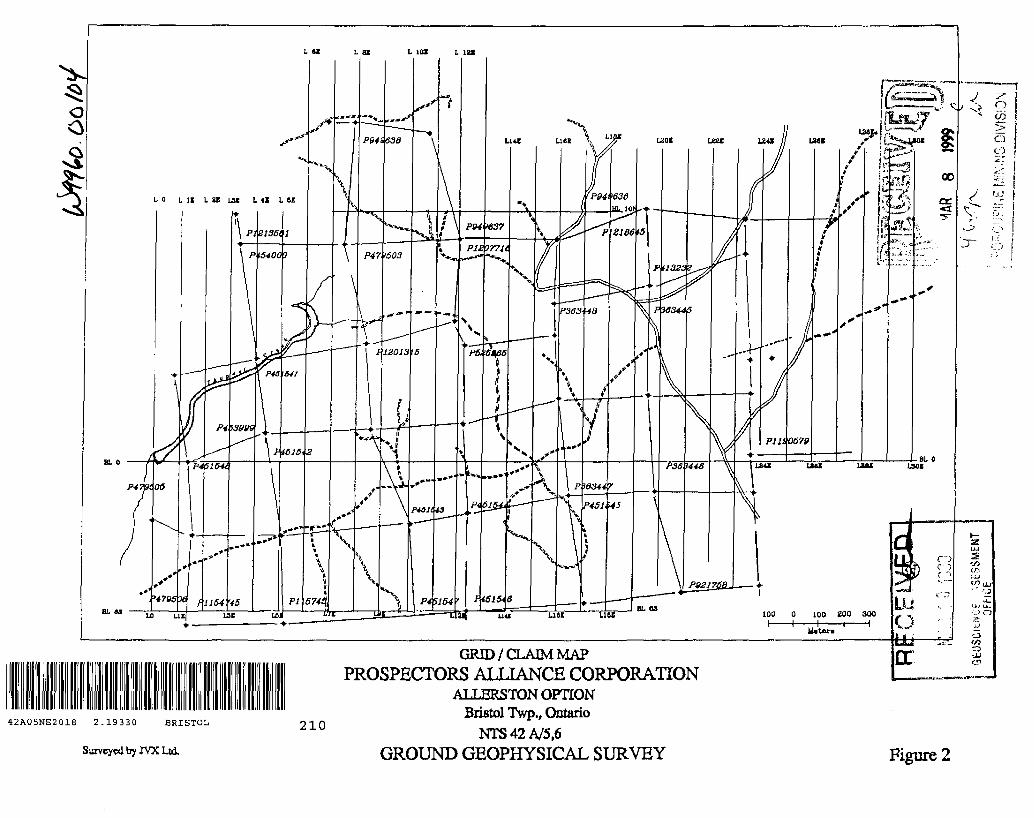
2.3 SURVEY GRID
* Coordinate Reference System: Local survey grid (non UTM)
* Established:
* Line Direction:
* Line Separation:
* Station Interval:
Prior to survey execution by Prospectors Alliance Corporation.
NOOOCE
100 meters
20 meters
PI 88 PROSPECTORS ALLIANCE CORP.Bristol RSIP
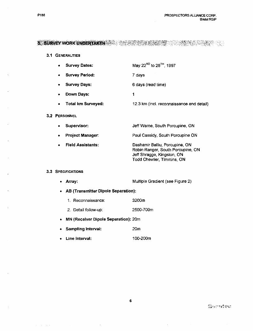
3.1 GENERALITIES
. Survey Dates: May 22ND to 28 , 1997
* Survey Period: 7 days
* Survey Days: 6 days (read time)
* Down Days: 1
* Total km Surveyed: 12.3 km (incl. reconnaissance and detail)
3.2 PERSONNEL
* Supervisor: Jeff Wame, South Porcupine, ON
* Project Manager: Paul Cassidy, South Porcupine ON
* Field Assistants: Dashamir Belliu, Porcupine, ONRobin Ranger, South Porcupine, ON Jeff Shragge, Kingston, ON Todd Chevrier, Timmins, ON
3.3 SPECIFICATIONS
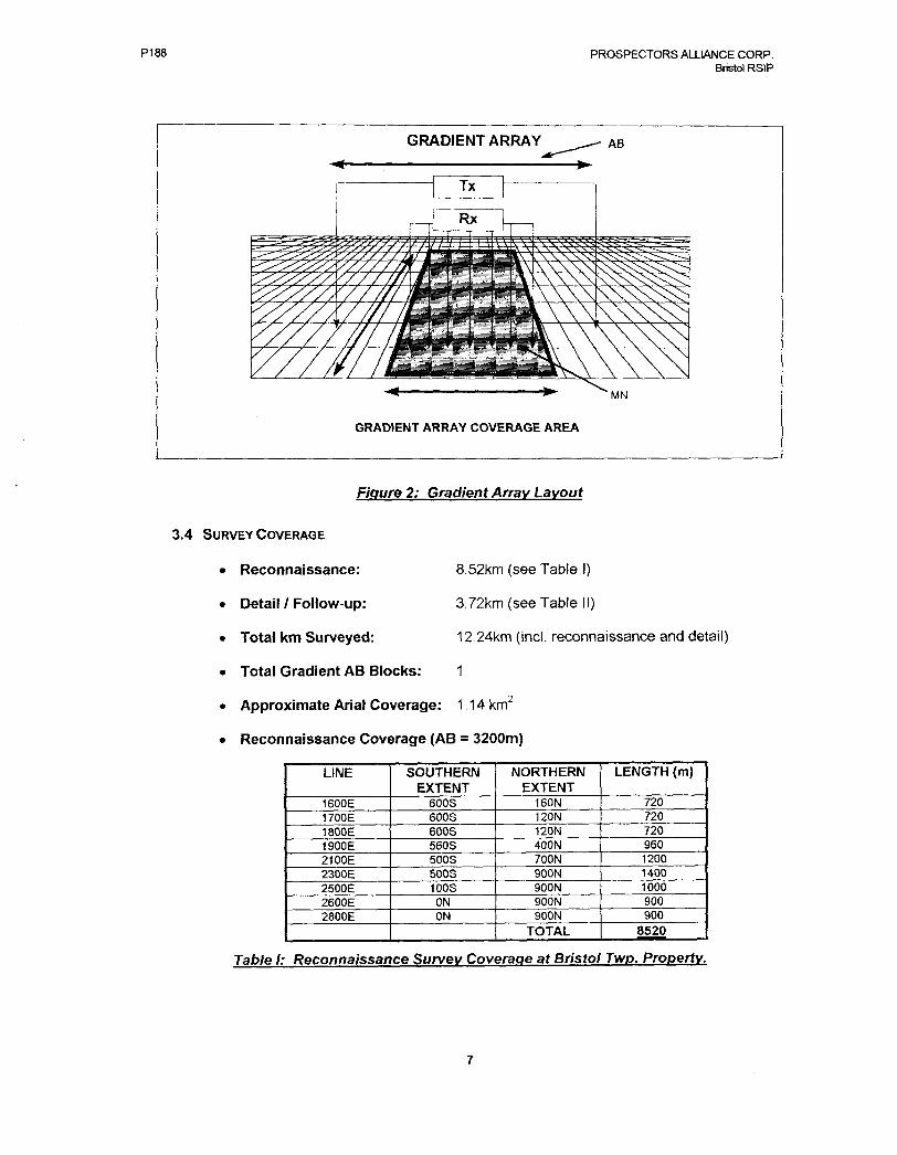
* Array: Multiple Gradient (see Figure 2)
* AB (Transmitter Dipole Separation):
1. Reconnaissance: 3200m
2. Detail follow-up: 2500-700m
* MN (Receiver Dipole Separation): 20m
* Sampling Interval: 20m
* Line Interval: 100-200m
P188 PROSPECTORS ALLIANCE CORP. Bristol RSIP
GRADIENT ARRAY COVERAGE AREA
Figure 2: Gradient Array Layout
3.4 SURVEY COVERAGE
* Reconnaissance:
* Detail l Follow-up:
* Total km Surveyed:
* Total Gradient AB Blocks:
8.52km (see Table l)
3.72km (see Table 11)
12.24km (incl. reconnaissance and detail)
1
* Approximate Arial Coverage: 1 14km
* Reconnaissance Coverage (AB = 3200m)
LINE
1600E1700E1800E1900E2100E2300E2500E2600E2800E
SOUTHERN EXTENT
600S600S600S560S500S500S100S
ONON
NORTHERN EXTENT
160N120N120N400N700N900N900N900N900N
TOTAL
LENGTH (m)
720720720960120014001000900900
8520
Table l: Reconnaissance Survey Coverage at Bristol Twp. Property.
P188 PROSPECTORS ALLIANCE CORP. Bristol RSIP
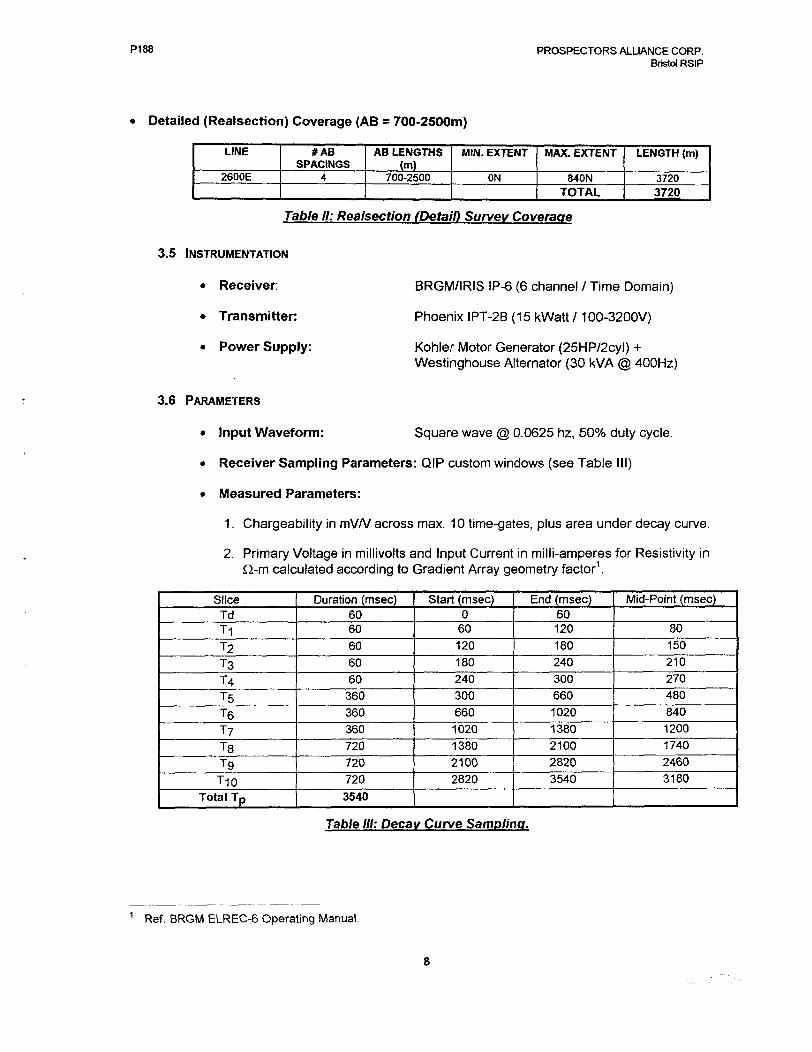
Detailed (Realsection) Coverage (AB = 700-2500m)
LINE
2600E
#AB SPACINGS
4
AB LENGTHS (m)
700-2500
MIN. EXTENT
ON
MAX. EXTENT
840NTOTAL
LENGTH (m)
37203720
Table II: Realsection (Detail) Survey Coverage
3.5 INSTRUMENTATION
* Receiver:
* Transmitter:
* Power Supply:
3.6 PARAMETERS
BRGM/IRIS IP-6 (6 channel /Time Domain)
Phoenix IPT-2B (15 kWatt 1 100-3200V)
Kohler Motor Generator (25HP72cyl) + Westinghouse Alternator (30 kVA @ 400Hz)
* Input Waveform: Square wave @ 0.0625 nz, 5007o duty cycle.
* Receiver Sampling Parameters: QIP custom windows (see Table III)
* Measured Parameters:
1. Chargeability in mV/V across max. 10 time-gates, plus area under decay curve.
2. Primary Voltage in millivolts and Input Current in milli-amperes for Resistivity in fi-m calculated according to Gradient Array geometry factor1 .
SliceTdT1T2T3
T4TST6
TyTSTgT10
Total Tp
Duration (msec)6060
60
60
60360
360
360
720
720
720
3540
Start (msec)0
60
120
180
240
300
660
1020
1380
2100
2820
End (msec)60120
180
240
300
660
1020
1380
2100
2820
3540
Mid-Point (msec)
80
150
210
270
480
840
1200
1740
2460
3180
Table III: Decay Curve Sampling.
1 Ref. BRGM ELREC-6 Operating Manual.
P188 PROSPECTORS ALLIANCE CORP. Bristol RSIP
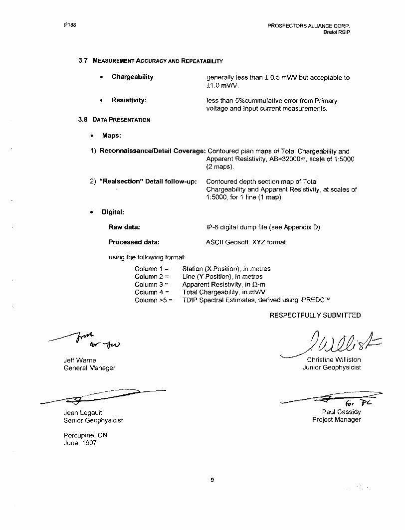
3.7 MEASUREMENT ACCURACY AND REPEATABILITY
generally less than 0.5 mV/V but acceptable to 1.0mVA/.
less than 50xbcummulative error from Primary voltage and Input current measurements.
* Chargeability:
* Resistivity:
3.8 DATA PRESENTATION
* Maps:
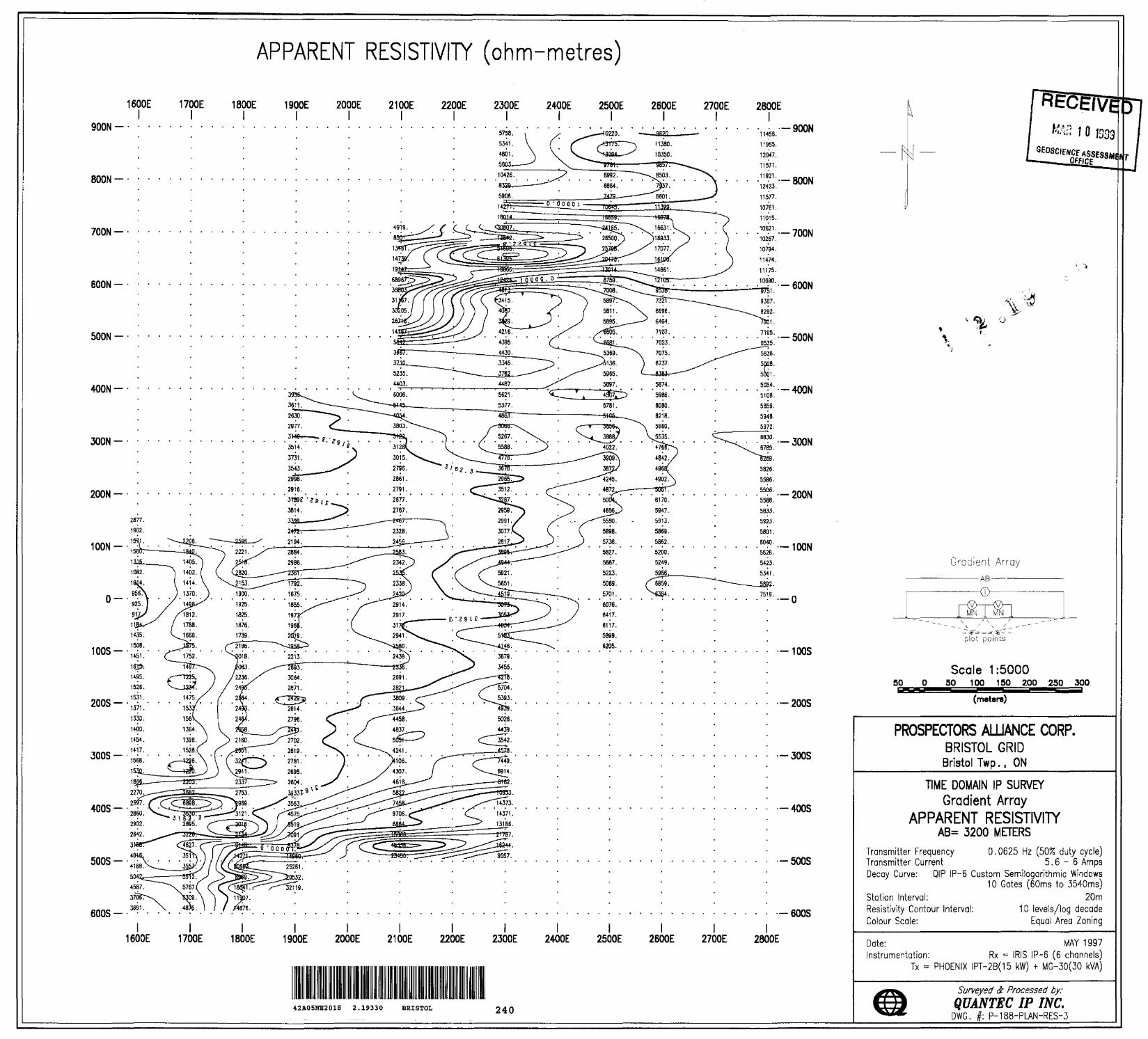
1) Reconnaissance/Detail Coverage: Contoured plan maps of Total Chargeability andApparent Resistivity, AB=32000m, scale of 1:5000 (2 maps).
2) "Realsection" Detail follow-up: Contoured depth section map of TotalChargeability and Apparent Resistivity, at scales of 1:5000, for 1 line (1 map).
Digital:
Raw data:
Processed data:
IP-6 digital dump file (see Appendix D)
ASCII Geosoft XYZ format.
using the following format:
Column 1 z Station (X Position), in metresColumn 2 = Line (Y Position), in metresColumn 3 s Apparent Resistivity, in Q-mColumn 4 = Total Chargeability, in mV/VColumn ^ = TDIP Spectral Estimates, derived using IPREDC
RESPECTFULLY SUBMITTED
Jeff Warn e General Manager
Christine Williston Junior Geophysicist
Jean Legault Senior Geophysicist
Porcupine, ON June, 1997
f*.Paul Cassidy
Project Manager
7 Prospectors Alliance Corp. 1997 Bristol RSIP
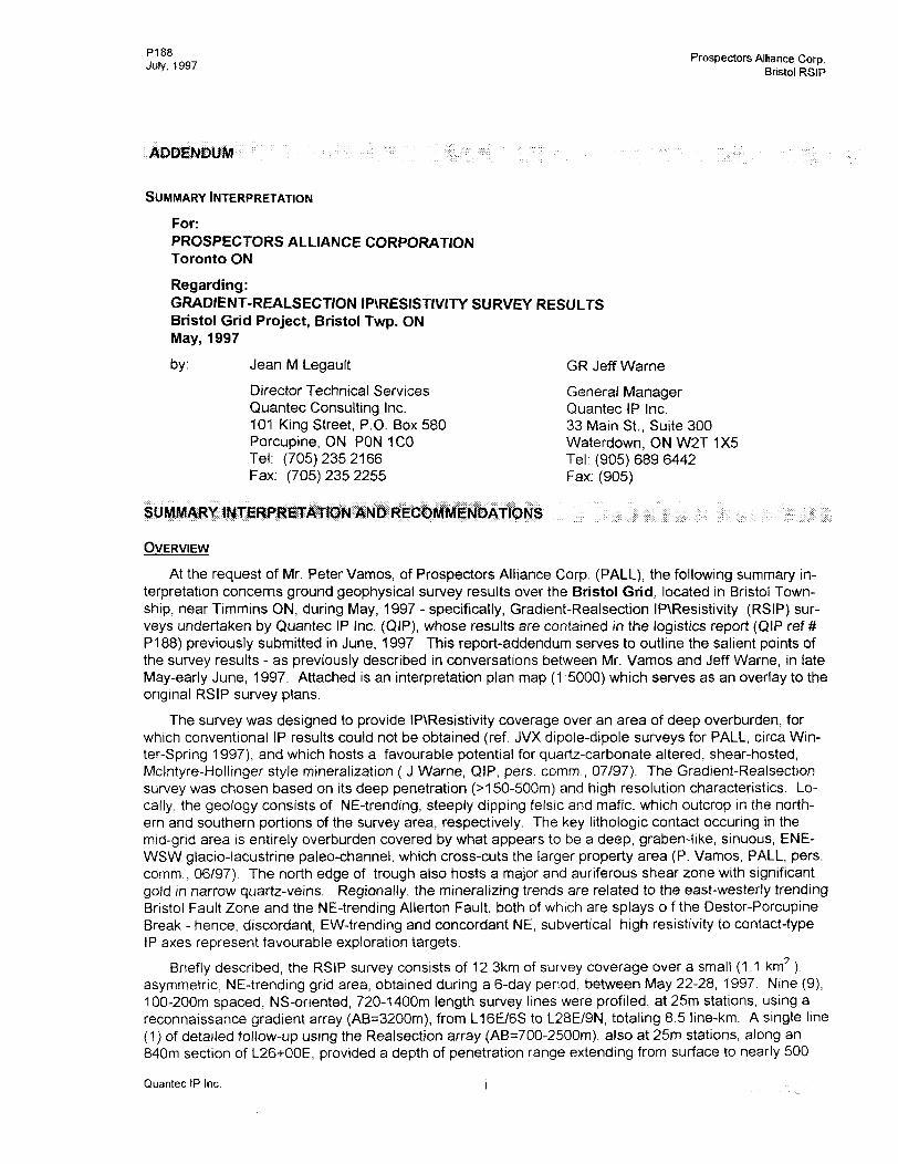
ADDENDUM ; - ; : ;; . ; ;f| ;: f ;: .i: "; : ' : : :. . ;; :.. , ,,
SUMMARY INTERPRETATION
For:PROSPECTORS ALLIANCE CORPORATIONToronto ON
Regarding:GRADIENT-REALSECTION IPVRESISTIVITY SURVEY RESULTSBristol Grid Project, Bristol Twp. ONMay, 1997
by: Jean M Legault GR Jeff Warne
Director Technical Services General ManagerQuantec Consulting Inc. Quantec IP Inc.101 King Street, P.O. Box 580 33 Main St., Suite 300Porcupine, ON PON 1CO Waterdown, ON W2T 1X5Tel: (705) 235 2166 Tel: (905) 689 6442Fax: (705) 235 2255 Fax: (905)
OVERVIEW
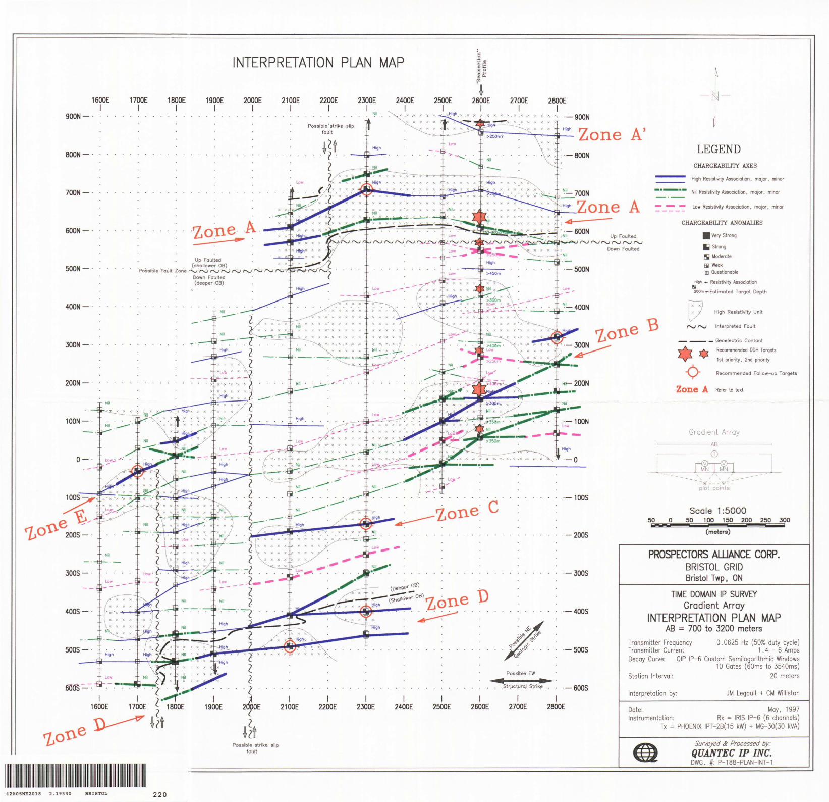
At the request of Mr. Peter Vamos, of Prospectors Alliance Corp. (PALL), the following summary in terpretation concerns ground geophysical survey results over the Bristol Grid, located in Bristol Town ship, near Timmins ON, during May, 1997 - specifically, Gradient-Realsection IP\Resistivity (RSIP) sur veys undertaken by Quantec IP Inc. (QIP), whose results are contained in the logistics report (QIP ref # P188) previously submitted in June, 1997. This report-addendum serves to outline the salient points of the survey results - as previously described in conversations between Mr. Vamos and Jeff Warne, in late May-early June, 1997. Attached is an interpretation plan map (1 :5000) which serves as an overlay to the original RSIP survey plans.
The survey was designed to provide IP\Resistivity coverage over an area of deep overburden, for which conventional IP results could not be obtained (ref. JVX dipole-dipole surveys for PALL, circa Win ter-Spring 1997), and which hosts a favourable potential for quartz-carbonate altered, shear-hosted, Mclntyre-Hollinger style mineralization ( J Warne, QIP, pers. comm., 07/97). The Gradient-Realsection survey was chosen based on its deep penetration (:*150-500m) and high resolution characteristics. Lo cally, the geology consists of NE-trending, steeply dipping felsic and mafic, which outcrop in the north ern and southern portions of the survey area, respectively. The key lithologic contact occuring in the mid-grid area is entirely overburden covered by what appears to be a deep, graben-like, sinuous, ENE- WSW glaciolacustrine paleo-channel, which cross-cuts the larger property area (P. Vamos, PALL, pers. comm., 06/97) The north edge of trough also hosts a major and auriferous shear zone with significant gold in narrow quartz-veins. Regionally, the mineralizing trends are related to the east-westerly trending Bristol Fault Zone and the NE-trending Allerton Fault, both of which are splays o f the Destor-Porcupine Break - hence, discordant, EW-trending and concordant NE, subvertical high resistivity to contact-type IP axes represent favourable exploration targets.
Briefly described, the RSIP survey consists of 12.3km of survey coverage over a small (1.1 km2 ), asymmetric, NE-trending grid area, obtained during a 6-day period, between May 22-28, 1997. Nine (9), 100-200m spaced, NS-oriented, 720-1 400m length survey lines were profiled, at 25m stations, using a reconnaissance gradient array (AB^3200m), from L16E/6S to L28E/9N, totaling 8.5 line-km. A single line (1) of detailed follow-up using the Realsection array ^6=700-2500 ), also at 25m stations, along an 840m section of L26+OOE, provided a depth of penetration range extending from surface to nearly 500
Quantec IP Inc j
P1 fifi. onv Prospectors Alliance Corp.
July ' 1997 Bristol RSIP
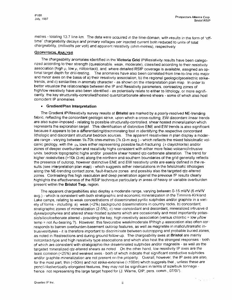
metres - totaling 13.7 line-km. The data were acquired in the time-domain, with results in the form of "off- time" chargeability decays and primary voltages per injected current both reduced to units of total chargeability, (millivolts per volt) and apparent resistivity (ohm-metres), respectively.
GEOPHYSICAL ANALYSIS
The chargeability anomalies identified in the Victoria Grid IP\Resistivity results have been catego rized according to their strength (questionable, weak, moderate), classified according to their resistivity association (high p, low p, nil/contact), and, where detailed RSIP coverage is available, assigned an op timal target depth for drill-testing. The anomalies have also been correlated from line-to-line into maior and minor axes on the basis of a) their resistivity association, b) the regional geologic/geoelectric strike- trends, and c) similarities in anomaly character - as shown on the interpretation plan map. In order to better visualize the relationships between the IP and Resistivity parameters, contrasting zones of high/low resistivity have also been identified - as potentially relate to either to lithology, or more signifi cantly, the key structurally-controlled/hosted quartz/carbonate altered shears - some of which also host coincident IP anomalies.
* Gradient/Plan Interpretation
The Gradient IP\Resistivity survey results at Bristol are marked by a poorly-resolved NE-trending fabric, reflecting the concordant geologic strike, upon which a cross-cutting, EW discordant linear trends are also super-imposed - relating to possible structurally-controlled, shear hosted mineralization which represents the exploration target. This identification of distinctive ENE and EW trends is also significant because it appears to be a differentiating/discriminating tool in identifying the respective concordant lithologic and discordant structural bedrock sources. The apparent resistivities in plan display a moder ate range - varying between 1k-70k ohm-metres (7k Q-m avg.) - which reflects the mixed felsic/mafic vol canic geology, with the pA lows either representing possible fault-fracturing ( clay/chlorite) and/or zones of deeper overburden and resistivity highs consistent with either more felsic volcanic/intrusive units, bedrock topographic highs and/or possible shear hosted qtz-carbonate alteration. The trend for higher resistivities (5-10k Q-m) along the northern and southern boundaries of the grid generally reflects the presence of outcrop, however distinctive ENE and EW resistivity units are easily defined in the re sults (see interpretation plan map) - which suggests either intercalations in the felsic/mafic lithologies along the NE-trending contact zone, fault-fracture zones and possibly also the targeted qtz-altered zones. Contrasting this high resolution and deep penetration against the previous IP results clearly highlights the effectiveness of the RSIP technique particularly in areas of heavy or variable overburden present within the Bristol Twp. region.
The apparent chargeabilities also display a moderate range, varying between 0-15 mV/V (6 mV./V avg.) - which is consistent with both stratigraphic and economic mineralization in the Timmins-Kirkland Lake camps, relating to weak concentrations of disseminated pyritic sulphides and/or graphite in a vari ety of forms - including: a) weak ^207o) background disseminations in country rocks, b) concordant, stratigraphic zones of mineralization (2-507o), c) near-concordant and discordant, mineralized intrusive d dykes/porphyries and altered shear-hosted systems which are occasionally and most importantly potas- sic/silicic/carbonate altered - providing the key, high resistivity association (versus chloritic = low p/low temp ^ not Au-bearing ?). However, this favourable weak/moderate IP/high p association also often cor responds to barren overburden-basement outcrop features, as well as magnetite in mafic/ultramafic in- trusives/dykes - it is therefore important to discriminate between outcropping and probable buried zones, as noted in Realsections and during ground follow-up. The chargeability axes at Bristol are mainly nil/contact-type and high resistivity type associations and which also host the strongest responses - both of which are consistent with stratigraphic-like disseminated sulphides and/or magnetite - as well as the targeted mineralized qtz-altered shears as noted. On the other hand, low resistivity IP axes are the least common ^257o) and weakest axes - both of which indicate that significant conductive sulphides and/or graphite mineralization are not present on the property. Overall, however, the IP axes are also, for the most part, thin ^50m) and not strike-extensive (s100m) which suggests that, unless these are pencil-like/vertically-elongated features, they may not be significant in terms of size/bulk tonnage - hence, not representing the large target hoped for (J. Warne, QIP, pers. comm., 07/97).
Quantec IP Inc. jj
P188 Prospectors Alliance Corp. Bristol RSIP
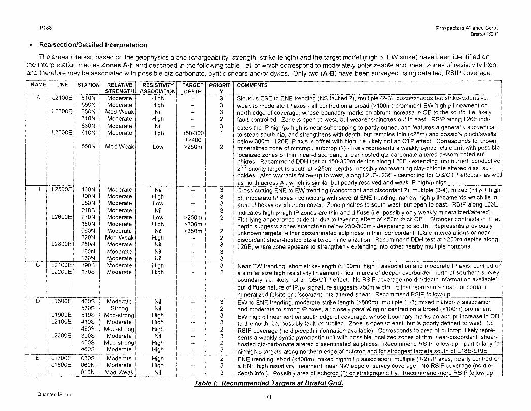
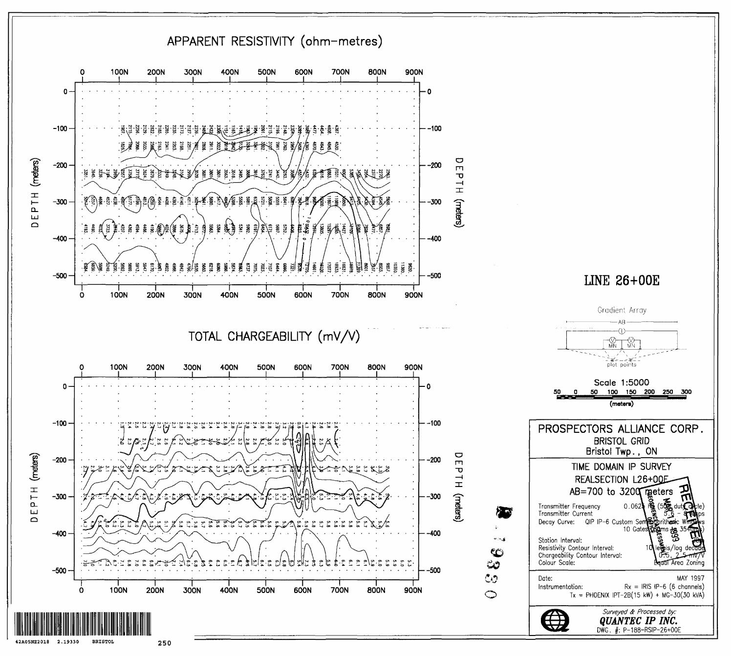
Realsection/Detailed Interpretation
The areas interest, based on the geophysics alone (chargeability, strength, strike-length) and the target model (high p, EW strike) have been identified on the interpretation map as Zones A-E and described in the following table - all of which correspond to moderately polarizeable and linear zones of resistivity high and therefore may be associated with possible qtz-carbonate, pyritic shears and/or dykes. Only two (A-B) have been surveyed using detailed, RSIP coverage.
NAME
A
B
C
D
U
LINE
L2100E
STATION
610N550N
L2300E 750NJ 71 ON
L2600E
L2500E
L2600E
L2800E
L2100EL2200E
L1800E
L1900EL2100E
L2200E
L1700EL1800E
630N610N
550N
160N100N050N010S270N160N060N320N250N 180N130N190S170S
460S530S510S410S490S300S400S460S
030S060N010N
RELATIVESTRENGTHModerateModerate
Mod-WeakModerateModerateModerate
Mod-Weak
ModerateModerateModerateModerateModerateModerateModerate
Mod-WeakModerate ModerateModerateModerateModerate
ModerateStrong
Mod-strongModerate
Mod-strongModerate
Mod-strongModerate
ModerateModerate
Mod-Weak
RESISTIVITYASSOCIATION
HighHighNil
HighNil
High
Low
NilHighLowNil
LowHighNil
HighNil NilNil
HighHigh
NilNil
HighHighHighNil
HighHigh
HighHighNil
TARGETDEPTH
-----
150-300+MOO^50m
--
^50m^OOm^50m
--
-~
-----~--
--
PRIORITY333231
2
3333212233332
32332323
233
COMMENTS
Sinuous ESE to ENE trending (NS faulted ?), multiple (2-3), discontinuous but strike-extensive,weak to moderate IP axes - all centred on a broad (MOOm) prominent EW high p lineament onnorth edge of coverage, whose boundary marks an abrupt increase in OB to the south, i.e. likelyfault-controlled. Zone is open to west, but weakens/pinches out to east. RSIP along L26E indi cates the IP high/pA high is near-subcropping to partly buried, and features a generally subverticalto steep south dip, and strengthens with depth, but remains thin ^25m) and possibly pinch/swellsbelow 300m. L26E IP axis is offset with high, i.e. likely not an DTP effect. Corresponds to knownmineralized zone of outcrop 1 subcrop (?) - likely represents a weakly pyritic felsic unit with possiblelocalized zones of thin, near-discordant, shear-hosted qtz-carbonate altered disseminated sul phides. Recommend DDH test at 150-300m depths along L26E - extending into buried, conductive2ND priority target to south at ^50m depths, possibly representing clay-chlorite altered diss. sul phides. Also warrants follow-up to west, along L21E-L23E - cautioning for OB/OTP effects - as wellas north across A', which is similar but poorly resolved and weak IP high/p high.Cross-cutting ENE to EW trending (concordant and discordant ?), multiple (3-4), mixed (nil p * highp), moderate IP axes - coinciding with several ENE trending, narrow high p lineaments which lie inarea of heavy overburden cover. Zone pinches to south-west, but open to east. RSIP along L26Eindicates high p/high IP zones are thin and diffuse (i.e. possibly only weakly mineralized/altered).Flat-lying appearance at depth due to layering effect of ^Om thick OB. Stronger contrasts in IP atdepth suggests zones strengthen below 250-300m - deepening to south. Represents previouslyunknown targets, either disseminated sulphides in thin, concordant, felsic intercalations or near-discordant shear-hosted qtz-altered mineralization. Recommend DDH test at ^50m depths alongL26E, where zone appears to strengthen - extending into other nearby multiple horizons
Near EW trending, short strike-length (*100m), high p association and moderate IP axis, centred ona similar size high resistivity lineament - lies in area of deeper overburden north of southern surveyboundary, i.e. likely not an OB/OTP effect. No RSIP coverage (no dip/depth information available),but diffuse nature of IP/PA signature suggests ^Om width. Either represents near-concordantmineralized felsite or discordant, qtz-altered shear. Recommend RSIP follow-up.EW to ENE trending, moderate strike-length ^500m), multiple (1-3) mixed nil/high p associationand moderate to strong IP axes, all closely paralleling or centred on a broad ^100m) prominentEW high p lineament on south edge of coverage, whose boundary marks an abrupt increase in OBto the north, i.e. possibly fault-controlled. Zone is open to east, but is poorly defined to west. NoRSIP coverage (no dip/depth information available). Corresponds to area of outcrop, likely repre sents a weakly pyritic pyroclastic unit with possible localized zones of thin, near-discordant, shear-hosted qtz-carbonate altered disseminated sulphides. Recommend RSIP follow-up - particularly fornil/high p targets along northern edge of outcrop and for strongest targets south of L18E-L19E.ENE trending, short ( *100m), mixed high/nil p association, multiple (1-2) IP axes, nearly centred ona ENE high resistivity lineament, near NW edge of survey coverage. No RSIP coverage (no dip-depth info.). Possibly area of subcrop (?) or stratigraphic Py. Recommend more RSIP follow-up.
Table l: Recommended Targets at Bristol Grid.
Quantec IP Inc.

Di ft fi7' rt ., Prospectors Alliance Corp. J"'y, 1997 Bristol RSIP
CONCLUSION AND RECOMMENDATIONS
The Gradient IP and Resistivity results at Bristol identify potential chargeability and resistivity sig natures relating to the subsurface geology, including possible lithologic discrimination, concordant and discordant fault-fracture structures, geochemical alteration and also weak concentrations of dissemi nated mineralization potentially associated with gold-mineralized, quartz/carbonate altered fault-fractures and shear zones.
In response to the geologic objectives, at least five (5) favourable, ESE to ENE trending, high- resistivity IP zones (Zones A to E), containing multiple chargeability axes, have been identified - includ ing three (3) which have been defined in the area of deep overburden. Of these zones, two (2) host sig nificant geoelectric characteristics resembling the target model (high/nil p, moderate IP, discordant EW- ESE trends) and sufficient Realsection coverage to warrant immediate drill-testing (Zones A, B) - as well, four (4) other weaker 2ND priority targets have also been identified along L26+OOE which could be tested at the same time. At least five (5) other targets hosting similar characteristics have also been identified for follow-up but require additional RSIP coverage prior to DDH testing. It should be noted, however, that the thin nature ^50m) and short strike length (ss150m) of all these anomalies suggests that theyrep- resent small targets - possibly not the large bulk mineable target sought after. Nevertheless, despite the varying overburden depths, which have limited previous IP survey results, this successful and straight forward result highlights the high resolution and deep penetration capabilities of the gradient Realsection technique - particularly the discrimination of both concordant ENE and discordant EW strike trends pos sibly relating to lithologic (barren ?) and structural (Au-bearing ?) targets, respectively.
We recommend that these results be combined with existing geoscientific information prior to follow- up. We also recommend that the current priority targets be carefully evaluated prior to and during the DDH-testing stage - particularly with regards to the target model and the apparently preferred EW-ENE orientations. When DDH-targeting, particular attention should also be given to optimal target depth as well as the probable type of mineralization/alteration indicated by the resistivity association - cautioning against possible basement topographic effects in areas of known outcrop. Additional RSIP follow-up on other buried targets identified in the survey area. As well, the Gradient-RSIP technique should be ap plied to other areas suspected to host either deep overburden or deeply buried targets. Finally, compari son with other geophysical results, particularly magnetics, should prove useful in distinguishing between pyritic and magnetite/pyrrhotite mineralization - the latter which also produce similar weak IP/high p sig natures.
RESPECTFULLY SUBMITTED
G.R. Jeff Warne Jean M. Legault Senior Geophysicist Senior Geophysicist
l ^
Christine Williston Geophysicist
Porcupine, ON July, 1997
Quantec IP Inc. iv
P188 PROSPECTORS ALLIANCE CORP. Bristol RSIP
STATEMENT OF QUALIFICATIONS
l, Jean M. Legault, declare that:
1 . l am a consulting geophysicist with residence in Timmins, Ontario and am presently employed in this capacity with the Quantec group, of Waterdown, Ontario.
2. l obtained a Bachelor's Degree, with Honours, in Applied Science (B.A.Sc.), Geological Engineering (Geophysics Option), from Queen's University at Kingston, Ontario, in Spring 1982.
3. l am a registered professional engineer (# 047032), with license to practice in the Province of Quebec, since 1985.
4. l have practiced my profession continuously since May, 1982, in North-America, South-America and North-Africa. "^**"*** *" f~ ** 0
5. l am a member of the Society of^EftgifiSersof Quebec, the QuebSc"Prospectors Association, the Prospectors and Developers Association of Canada, and the Society of Exploration Geophysicists.
6. l have no interest, nor do l expect to receive any interest in the properties or securities of Prospectors Alliance Corp.
7. l oversaw the interpretation, the report preparation, the final drawings, and provided the recommenda tions attached and hereby attest to their accuracy herein.
8. The statements made in this report represent my professional opinion based on my consideration of the information available to me at the time of writing this report.
Porcupine, Ontario June, 1997
Jean M. Legault, P.Eng. Chief Geophysicist Dir. Technical Services Quantec Group

P188 PROSPECTORS ALLIANCE CORP. Bristol RSIP
STATEMENT OF QUALIFICATIONS
l, Christine Williston, hereby declare that:
1. l am a processing geophysicist with residence in South Porcupine, Ontario and am presently employed in this capacity with Quantec Consulting Inc. of Porcupine, Ontario.
2. l am a graduate of York University, North York, ON, in 1994, with an Honours Bachelor of Science De gree in Earth and Atmospheric Science.
3. l have practiced my profession in Canada since graduation.
4. l have no interest nor do l expect to receive any interest, direct or indirect, in the properties or securi ties of Prospectors Alliance Corp.
5. The maps created in this report accurately represent the information given to me at the time of the preparation of this report.
Porcupine, Ontario June, 1997
Christine Williston, B.Sc. Processing Geophysicist Quantec Technical Services
P188 PROSPECTORS ALLIANCE CORP. Bristol RSIP
STATEMENT OF QUALIFICATIONS
l, G.R. Jeffrey Warne, hereby declare that:
1. l am a geophysicist with residence in South Porcupine, Ontario and am presently employed in this capacity with Quantec IP Inc. of Waterdown, Ontario.
2. l studied Engineering Geophysics in the Faculty of Applied Science at Queen's University in Kingston, Ontario, completing all but two of the course requirements for a B.Sc.(Eng.) in 1981.
3. l have practiced my profession continuously since May, 1981 in Canada, the United States and Chile.
4. l have no interest, nor do l expect to receive any interest in the properties or securities of Prospectors Alliance Corp.
5. The statements made in this report represent my professional opinion based on my consid eration of the information available to me at the time of writing this report.
Porcupine, Canada June, 1997
G.R. Jeffrey Wame Senior Geophysicist General Manager- QIP
P188 PROSPECTORS ALLIANCE CORP.Bristol RSIP
THEORETICAL BASIS
The "RealSection" survey design uses multiple gradient arrays - with variable depths of in vestigation controlled by successive changes in array size/geometry. The method of data acquisition and the "RealSection" presentation are based on the specifications developed by Dr. Perparim Alikaj, of the Polytechnic University of Tirana, Albania, over the course of 10 years of application. This technique has been further developed for application in Canada during the past four years, in asso ciation with Mr. Dennis Morrison, president of Quantec IP Inc.
The Gradient Array measurements are unique in that they best represent a bulk average of the surrounding physical properties within a relatively focused sphere of influence, roughly equal to the width of the receiver dipole, penetrating vertically downward from surface to great depths. These depth of penetration and lateral resolution characteristics are showcased when presented in plan, however through the use of multiple-spaced and focused arrays, the advantages of the gradient ar ray are further highlighted when the IP/Resistivity data are fully developed in cross-section, using RealSections.
The resistivity is among the most variable of all geophysical parameters, with a range ex ceeding 106 . Because most minerals are fundamentally insulators, with the exception of massive accumulations of metallic and submetallic ores (electronic conductors) which are rare occurrences, the resistivity of rocks depends primarily on their porosity , permeability and particularly the salinity of fluids contained (ionic conduction), according to Archie's Law. In contrast, the chargeability re sponds to the presence of polarizeable minerals (metals, submetallic sulphides and oxides, and graphite), in amounts as minute as parts per hundred. Both the quantity of individual chargeable grains present, and their distribution with in subsurface current flow paths are significant in control ling the level of response. The relationship of chargeability to metallic content is straightforward, and the influence of mineral distribution can be understood in geologic terms by considering two similar, hypothetical volumes of rock in which fractures constitute the primary current flow paths. In one, sul phides occur predominantly along fracture surfaces. In the second , the same volume percent of sulphides are disseminated throughout the rock. The second example will, in general, have signifi cantly lower intrinsic chargeability.
P188 PROSPECTORS ALLIANCE CORP. Bristol RSIP
y-a
Y
1A jr
x isk
LJM ; N
: * ^- V./1VIC
X B
Figure C1:: Gradient array configuration
Using the diagram in Figure C1 for the gradient array electrode configuration and nomen clature: 2, the gradient array apparent resistivity is calculated:
where: the origin O is selected at the center of ABthe geometric parameters are in addition to a s AB/2 and b s MN/2 X is the abscissa of the mid-point of MN (positive or negative) Y is the ordinate of the mid-point of MN (positive or negative)
Gradient Array Apparent Resistivity:VP
where: K =
ohm-metres
2n(AM'1 -AN'1 -BM'1 + BN'1 )
= ^I(a+x-b)2 +y 2
+y
+y
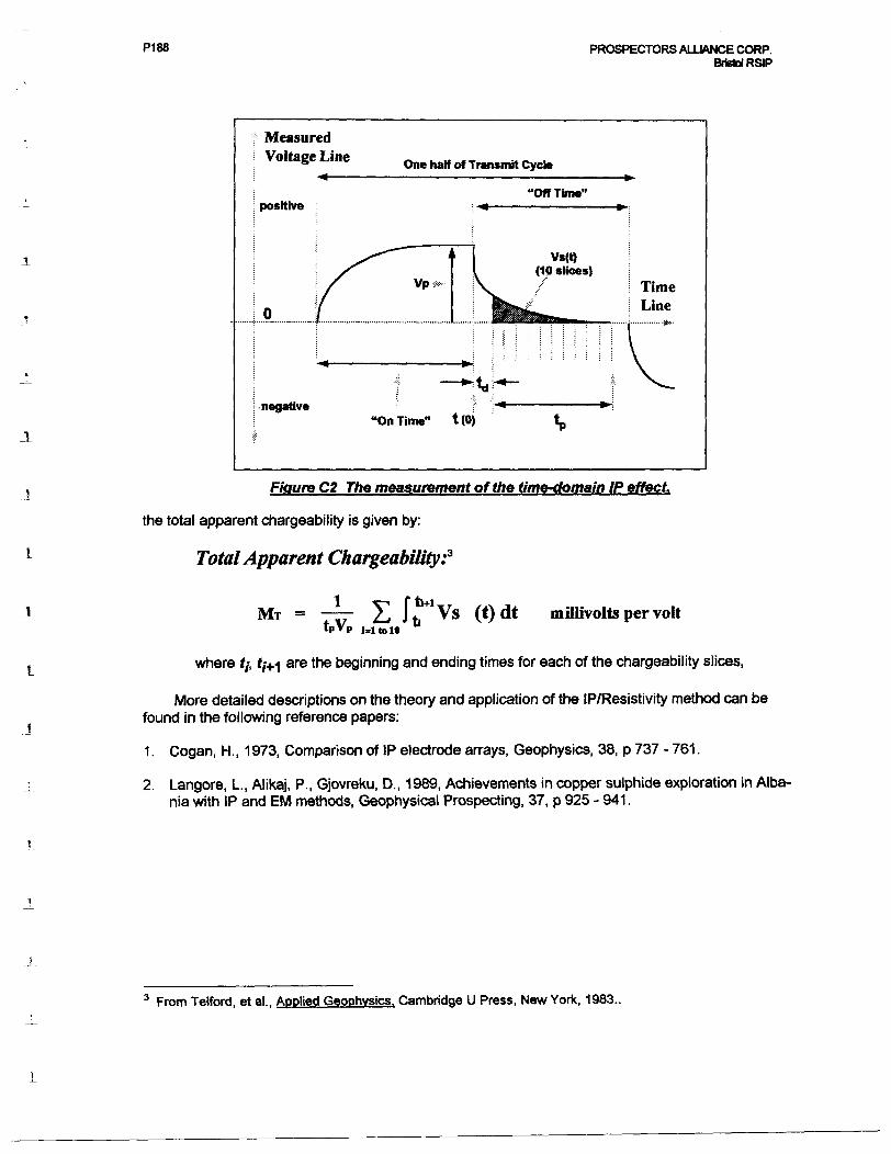
Using the diagram in Figure C2 for the Total Chargeability:
From Terraplus\BRGM, IP-6 Operating Manual, Toronto, 1987.
P188 PROSPECTORS ALLIANCE CORP. Bristol RSIP
l
Measured Voltage Line One half of Transmit Cycle
positive"Off Time"
•negative"On Time" t (0)
Figure C2 The measurement of the time-domain IP effect.
the total apparent chargeability is given by:
Total Apparent Chargeability:3
l v-Mr = (*)dt mUlivolts per volt
where t;, t;^ are the beginning and ending times for each of the chargeability slices,
More detailed descriptions on the theory and application of the IP/Resistivity method can be found in the following reference papers:
1 . Cogan, H., 1 973, Comparison of IP electrode arrays, Geophysics, 38, p 737 - 761 .
2. Langore, L., Alikaj, P., Gjovreku, D., 1989, Achievements in copper sulphide exploration in Alba nia with IP and EM methods, Geophysical Prospecting, 37, p 925 - 941.
3 From Telford, et al., Applied Geophysics. Cambridge U Press, New York, 1983..
P188 PROSPECTORS ALLIANCE CORP. Bristol RSIP
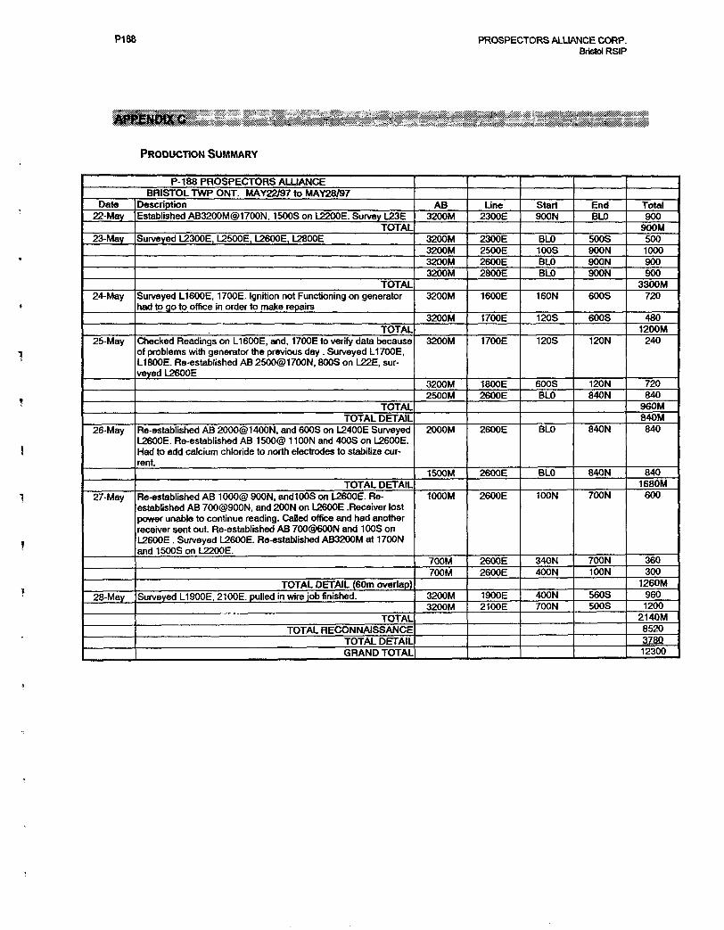
PRODUCTION SUMMARY
P-188 PROSPECTORS ALLIANCEBRISTOL TWP ONT. MAY22/97 to MAY28/97
Date22-May
23-May
24-May
25-May
26-May
27-May
28-May
DescriptionEstablished AB3200M@1700N, 1500S on L2200E. Survey L23E
TOTALSurveyed L2300E, L2500E, L2600E, L2800E
TOTALSurveyed L1600E, 1700E. Ignition not Functioning on generator had to go to office in order to make repairs
TOTALChecked Readings on L1600E, and, 1700E to verify data because of problems with generator the previous day . Surveyed L1700E, L1800E. Re-established AB 2500@1700N, 800S on L22E, sur veyed L2600E
TOTALTOTAL DETAIL
Re-established AB 2000@1400N, and 600S on L2400E Surveyed L2600E. Re-established AB 1500@ 1 100N and 400S on L2600E. Had to add calcium chloride to north electrodes to stabilize cur rent.
TOTAL DETAILRe-established AB 1000@ SOON, andlOOS on L2600E. Re established AB 700@900N, and 200N on L2600E .Receiver lost power unable to continue reading. Called office and had another receiver sent out. Re-established AB 700@600N and 100S on L2600E . Surveyed L2600E. Re-established AB3200M at 1700N and 1500S on L2200E.
TOTAL DETAIL (60m overlap)Surveyed L1900E, 2100E. pulled in wire job finished.
TOTALTOTAL RECONNAISSANCE
TOTAL DETAILGRAND TOTAL
AB3200M
3200M3200M3200M3200M
3200M
3200M
3200M
3200M2500M
2000M
1500M
1000M
700M700M
3200M3200M
Line2300E
2300E2500E2600E2800E
1600E
1700E
1700E
1800E2600E
2600E
2600E
2600E
2600E2600E
1900E2100E
Start900N
BLO100SBLOBLO
160N
120S
120S
600SBLO
BLO
BLO
100N
340N400N
400N700N
EndBLO
500SSOON900NSOON
600S
600S
120N
120N840N
840N
840N
700N
700N100N
560S500S
TotalSOO
900M5001000SOOSOO
3300M720
4801200M
240
720840
S60M840M840
8401680M
600
360300
1260MS601200
2 140 M8520378012300
P188 PROSPECTORS ALLIANCE CORP. Bristol RSIP
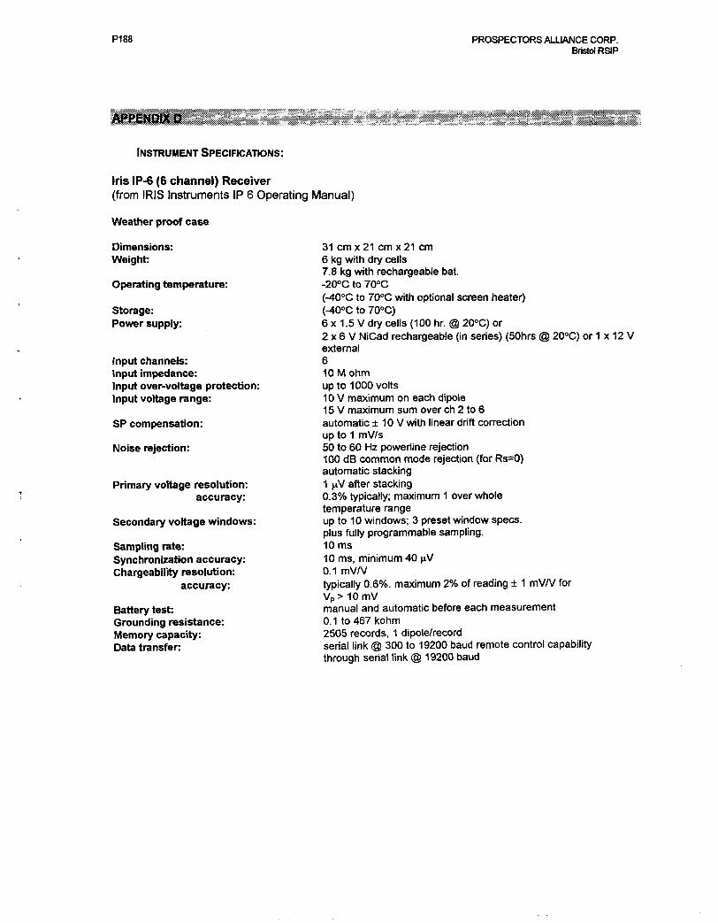
INSTRUMENT SPECIFICATIONS:
Iris IP-6 (6 channel) Receiver(from IRIS Instruments IP 6 Operating Manual)
Weather proof case
Dimensions: Weight:
Operating temperature:
Storage: Power supply:
Input channels:Input impedance:Input over-voltage protection:Input voltage range:
SP compensation:
Noise rejection:
Primary voltage resolution: accuracy:
Secondary voltage windows:
Sampling rate: Synchronization accuracy: Chargeability resolution:
accuracy:
Battery test: Grounding resistance: Memory capacity: Data transfer
31 cm x 21 cm x 21 cm6 kg with dry cells7.8 kg with rechargeable bat.-2^0 to 70DC(-400C to 700C with optional screen heater)(~400C to 700C)6 x 1.5 V dry cells (100 hr. @ 200C) or2 x 6 V NiCad rechargeable (in series) (50hrs @ 200C) or 1 x 12 Vexternal610 M ohmup to 1000 volts10V maximum on each dipole15V maximum sum over eh 2 to 6automatic 10 V with linear drift correctionup to 1 mV/s50 to 60 Hz poweriine rejection100 dB common mode rejection (for Rs^)automatic stacking1 ^V after stackingQ.3% typically; maximum 1 over wholetemperature rangeup to 10 windows; 3 preset window specs.plus fully programmable sampling.10 ms10 ms, minimum 40 ^V0.1 mV/Vtypically Q.6%. maximum 2Vo of reading ± 1 mV/V forVp> 10 mVmanual and automatic before each measurement0.1 to467kohm2505 records, 1 dipole/recordserial link @ 300 to 19200 baud remote control capabilitythrough serial link @ 19200 baud
P188 PROSPECTORS ALLIANCE CORP. Bristol RSIP
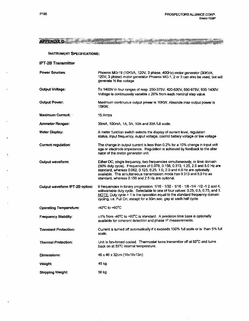
INSTRUMENT SPECIFICATIONS:
IPT-2B Transmitter
Power Sources:
Output Voltage:
Output Power
Maximum Current:
Ammeter Ranges:
Meter Display:
Current regulation:
Output waveform:
Output waveform IPT-2B option:
Operating Temperature:
Frequency Stability:
Transient Protection:
Thermal Protection:
Dimensions:
Weight:
Shipping Weight:
Phoenix MG-19 (10KVA, 120V, 3 phase, 400Hz) motor generator (30KVA, 120V, 3 phase) motor generator Phoenix MG-1, 2 or 3 can also be used, but will generate V* the voltage
To 1400V in four ranges of resp. 250-375V, 420-630V, 650-975V, 935-1400V. Voltage is continuously variable 200Xo from each nominal step value.
Maximum continuous output power is 10KW. Absolute max output power is 15KW.
15 Amps
30mA, 100mA, 1A, 3A, 10A and 30A full scale.
A meter function switch selects the display of current level, regulation status, input frequency, output voltage, control battery voltage or line voltage
The change in output current is less than Q.2% for a 100Xo change in input volt age or electrode impedance. Regulation is achieved by feedback to the alter nator of the motor generator unit.
Either DC, single frequency, two frequencies simultaneously, or time domain (50"Xo duty cycle). Frequencies of 0.078, 0.156, 0.313,1.25, 2.5 and 5.0 Hz are standard, whereas 0.062, 0.125, 0.25,1.0,2.0 and 4.0 Hz are optionally available. The simultaneous transmission mode has 0.313 and 5.0 Hz as standard, whereas 0.156 and 2.5 Hz are optional.
9 frequencies in binary progression: 1/16 -1/32 -1/16 -1/8 -1/4 -1/2 -1 2 and 4, withvariable duty cycle. Selectable to one of four values: 0.25, 0.5, 0.75, and 1. NOTE: Duty cycle = 1 is the operation equal to the standard frequency domain cycling, i.e. Full On, except for a 50m.sec. gap at each half cycle.
-400Cto-f600C
1 07o from -400C to 4600C is standard. A precision time base is optionally available for coherent detection and phase IP measurements.
Current is turned off automatically if it exceeds 1500Xo full scale or is than 50Xo full scale.
Unit is fan-forced cooled. Thermostat turns transmitter off at 650C and turns back on at 550C internal temperature.
46 x 46 x 32cm (18x18x1 Sin)
45kg
56kg
PI 88 PROSPECTORS ALLIANCE CORP. Bristol RSIP
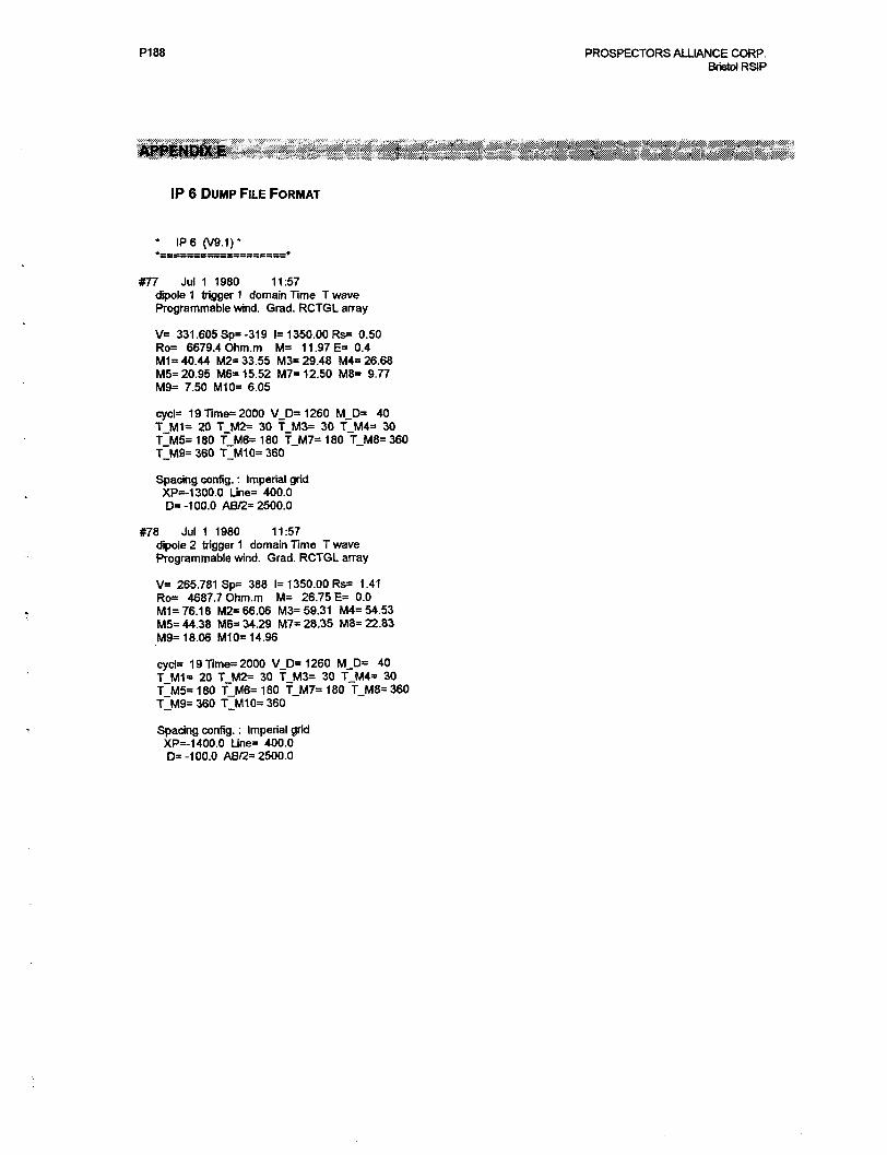
IP 6 DUMP FILE FORMAT
IP 6 (V9.1)*
#77 Jul 1 1980 11:57dipole 1 trigger 1 domain Time T wave Programmable wind. Grad. RCTGL array
V= 331. 605 Sp= -31 9 1=1 350.00 Rs^ 0.50 Ro= 6679.4 Ohm.m M= 11. 97 E* 0.4 1^11=40.44 M2*33.55 M3~29.48 1^/14=26.68 1^15=20.95 M6= 15.52 1^17=12.50 MS* 9.77 M9* 7.50 M10= 6.05
cyc^ 19111716=2000 V_D=1260 M_D= 40 TJ/H* 20 T_M2= 30 T_M3= 30 T.M4* 30 T_M5= 180 T.M6s 180 T_M7= 180 T_M8= 360 ^^19=360 TJMI 0=360
Spacing config. : Imperial grid XP-1 300.0 IJne= 400.0 D' -100.0 08/2=2500.0
#78 Jul 1 1980 11:57dipole 2 trigger 1 domain Time T wave Programmable wind. Grad. RCTGL array
V= 265.781 Sp* 388 1=1 350.00 Rs= 1.41 Ro* 4687.7 Ohm.m M= 26.75 E= 0.0 1^1=76.18 M2* 66.06 IV^ 59.31 1^14=54.53 1^15=44.38 MB* 34.29 1^17=28.35 1718=22.83 1^9=18.06 M^ 14.96
cycls 19Time=2000 V_D=1260 MJ3* 40 ^Ml" 20 T_M2= 30 TJ^ 30 T_M4= 30 ^5=180 ^1^16=180 ^1^17=180 ^1^8=360 ^1^19=360 ^1^/110=360
Spacing config. : Imperial grid XPs-1 400.0 Lk^ 400.0 D' -100.0 AB^ 2500.0

P188
OPERATOR COMMENTS
PROSPECTORS ALLIANCE CORP. Bristol RSIP
P188 PROSPECTORS ALLIANCE CORP. Bristol RSIP
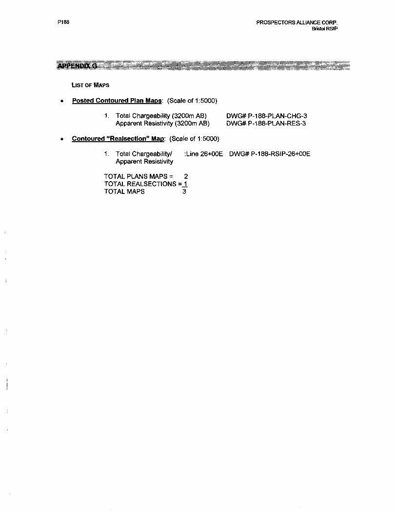
LIST OF MAPS
Posted Contoured Plan Maps: (Scale of 1:5000)
1. Total Chargeability (3200m AB) DWG# P-188-PLAN-CHG-3 Apparent Resistivity (3200m AB) DWG# P-188-PLAN-RES-3
Contoured "Realsection" Map: (Scale of 1:5000)
1. Total Chargeability/ :Line26+OOE DWG# P-188-RSIP-26+OOE Apparent Resistivity
TOTAL PLANS MAPS = 2 TOTAL REALSECTIONS s J. TOTAL MAPS 3

P188
PLAN MAPS AND SECTION
PROSPECTORS ALLIANCE CORP. Bristol RStP
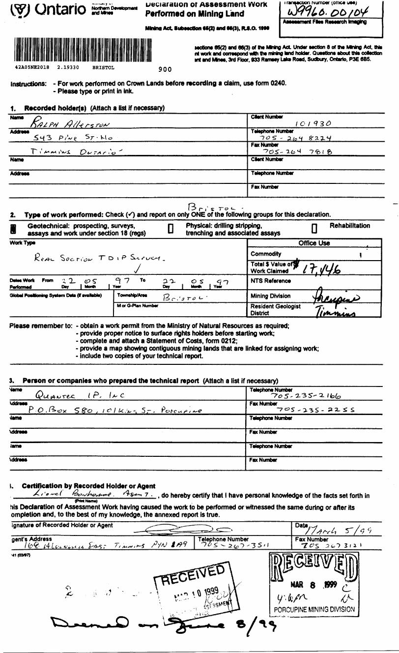
Ontario and MmDeclaration or Assessment Work Performed on Mining LandMMna Act Subsection tJ0) and M(9), PLS.O. ItM
Numoer (otiic* UM;
Aaeeaament Flea Research tmaglng
MCtxma 85(2) and 86(3) of lha MMng Act Under section 8 of ttw MWng Act, thte rt work and correspond wth ttw mining land hoUer. QuesUona about tN* cotocbon mt and Mkiaa. 3rd Floor. 833 Rameey Lake Road, Sudbury, Ontario. P3E 6BS.
42A05NE2018 2.19330 BRISTOL 900
Instructions: - For work performed on Crown Lands before recording a claim, use form 0240. - Please type or print in ink.
1. Recorded holderts) (Attach a list if necessary)Name CMC* NufflMr
1C lAddress sr- - a/of g a-
Fax NumberA r 6
Name Clent Number
Addreea Tttophono Number
Fax Number
13 r i' s TO i- - 2. Type of work performed: Check (*0 and report on only ONE of the following groups for this declaration.
Geotechnical: prospecting, surveys, assays and work under section 18 (regs) D Physical: drilling stripping,
trenching and associated assays D Rehabilitation
Work Type
yDrtMWorfc From i 2- CP S" ^ 7 T* 20- OS Cjf-J
rtlnhBl Iftn^Mnmlnra 1*lHlalll F^^M *1* M-*.!-* TovwMMp'AfM O , -/o r . ' j r o t-M or G-Plan Number
Office UseCommodity
Total S Value ofW . n tt It Wortc Claimed t l] y^fJoNTS Reference
yjMining Division WAuAtmResident Geologist f, l . District lltto^kAM*
1
^
t
Please remember to: - obtain a work permit from the Ministry of Natural Resources as required;- provide proper notice to surface rights holders before starting work;- complete and attach a Statement of Costs, form 0212;- provide a map showing contiguous mining lands that are linked for assigning work;- include two copies of your technical report.
3. Person or companies who prepared the technical report (Attach a list if necessary) tone ^
C^j^rec i P, f/- C\ddraee
P-O./^-cJx ^g-o , \o\ k.W't 5- - Pot-c~?'i*~e4tTM
\ddraes
lam*
VddrM*
Telephone Number 7^5 -a 3 5' 2. Jfot,
Fax Number -70S -0-3S - S2- S S
Tttophono Number
Fax Number
tophocw Number
Fax Number
\. Certification by Recorded Holder or AgentX/'/.^o/' /bUv/Aiv^w ^s-^, 7 . , do hereby certify that l have personal knowledge of the facts set forth in
(PfWlt NkVTW)
Ms Declaration of Assessment Work having caused the work to be performed or witnessed the same during or after its ompletion and, to the best of my knowledge, the annexed report is true.ignature of Recorded Holder or Agent
gent's Address
Date7/Wi r-Fax Number
•41(03*7)
MAR 8 .1999
PORCUPINE MINING DIVISION
Oo/U 1*'"" ice. li. oo rAA i^i ^,, j 1B BcALLbl/ s performed. at UK tom nctfc WM performed. A imp showing UM contiguous link must accompany
.Of!
//J
to
12
14
IS
ft!
li
IMU.FVMMT
tt la
tun
a-f a-
to Mi
f oO
\J
.L.. do hereby certify that Ut* above work credits m etiQibia under subsection 7 (J) of the Assessment Vtfortt Regulation M6 fer aMipximanl to oonUgijout claims or for appUcaUon to Vie daitn wham the wont was dona.
•. Instnicttont tor cutting back cntdtttttwt m not ipprovttf.
Some of the credits claimed in INs dtdaraUon may lw cut btcfc. Ptem chock (O In In* boxw below to thow how you wish lo prtofttiza th* 4*M)on of cradits:
m 1.Cr^ltetretob*cutbw*fromlhtBinkhYit,foflow^byopUm2or3()f4Mln*c*ltd.tt * i iiiiim* mm In Im mil Imiik Mmlhiy wWi Ilw iiMiira (Mwl toirti WMfWfiy iHMiftwrnO*, nrU a. Ciautu ma to Ua cm tmcfc xiurtiy owr itfi ctoifiM KMad In mn o^clamugo; orQ 4. Cr*diuaf*tob*cutbackMprionVzadonth*MUci^app*ndUorMfoUows(dMcnb*;:
\
Moo: tf you hav* not tndterted how your crtdto ara to bo dMUd. owtts wifl b* oil tack from UM Bank flnl,
For Offioi Ut* Only
AyewMdtaf MmrtkiQejf Mbiin0 wtttittt (SlDnMuraf
HOY 04 '99 12:59 2673121 PflGE.82
Received Stamp
0241 (OM7)
UOTIIIVU nfifnwrau i/mv
Date Approved
.
Total Value of Credit Approved
Approved for Recording by Mining Recorder (Signature)
PORCUPINE MINING DIVISION
Ontario' of,. Development
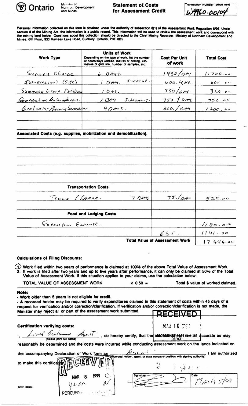
and MinesStatement of. Coste for Assessment Credit
Transaction Number (office UM)
Personal information collected on this form is obtained under the uthorlly of subsection 6(1) o* the Assessment Work Regulation 6/B6. Under section 8 of the Mining Act. the information is a public record. This information will be used to review the assessment work and correspond with the mining land holder. Questions about this collection should be directed to the Chief Mining Recorder, Ministry of Northern Development and Mines. 6th Floor, 933 Ramsay Lake Road. Sudbury. Ontario, P3E 6B5.
Work Type
-5CV A-/ ) c* "7 C. M /9 T"a p
fV^^r^T ^'*^
otiAi/w/fcStf ls~Terf . C-^'lliSf^
^,v4S,^^W^W7.
fere ii,*. t ?r?Jf*'^^#'v*-
Units of WorkDepending on the type of work, list the number of hours/days worked, metres of drilling, kilo metres of grid line, number of ssmples, etc.
h 6A^Z,
1 04+1. 3'-'""-**-
l 0*1.
, OA^, ^^^7-
V/Q^S-
Associated Costs (e.g. supplies, mobilization and demobilization).
Transportation Costs
-7-r ̂ L ^ ( /^ 4 ^ 7 ,;^-
Food and Lodging Costs
CWe-tf,-,- e*"~**-
Cost Per Unit of work
;?**A*vt,oo,fa*i.
3SO/0A1.
7r*.f*.*n,300./0+*
VT-XdVM
^sr .Total Value of Assessment Work
Total Cost
l/ -70& .00
i) C ei eo
3 SC . o ^
-75 C . "^
X -2-OC" , ^ ^
^?LS.-o
J / S^ f^\ *0 C^"r f O t-^ * ^-^
/ r^fV - e.0
f f r i" V '
Calculations of Filing Discounts:
jj* Work filed within two years of performance is claimed at KXWfe of the above Total Value of Assessment Work. 2. If work is filed after two years and up to five years after performance, it can only be claimed at 50*M) of the Total
Value of Assessment Work. If this situation applies to your claims, use the calculation below:
TOTAL VALUE OF ASSESSMENT WORK x 0.50 Total S value of worked claimed.
Not*:- Work older than S years is not eligible for credit.- A recorded holder may be required to verify expenditures claimed in this statement of costs within 45 days of a request for verificatioa and/or correction/clarification. If verification and/or correction/clarification is not made, theMinister may reject all or part of the assessment work suDmmed.
Certification verifying costs:
l f A''^ (2Wi~ ̂ /4b*.iT do hereby riertify, that the(please print lull name)
RECEiVED j
M " :"' 1 fi ' or i i . il\ 1 U ,. li, J ;
attWflttWSfiewJf we St accurateOFFICE T
as may
reasonably be determined and the costs were incurred while conducting assessment work on the lands indicated on
the accompanying Declaration of Work form as——— ~~~ ———
to make this certifica
0212 (02/9*)
MAR 8 1999 C. l
'___ ______ __________corded holder, agent, or Mat* company petition with signing authority)
l am authorized
Ministry ofNorthern Developmentand Mines
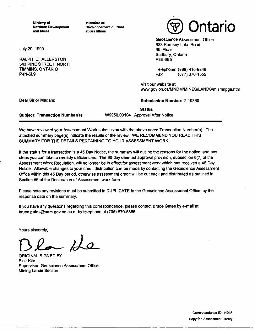
July 20, 1999
RALPH E. ALLERSTON 543 PINE STREET, NORTH TIMMINS, ONTARIO P4N-6L9
Mlnlstere du Developpement du Nord et des Mines Ontario
Dear Sir or Madam:
Subject: Transaction Number(s):
Geoscience Assessment Office 933 Ramsey Lake Road 6th Floor Sudbury, Ontario P3E 6B5
Telephone: (888)415-9846 Fax: (877)670-1555
Visit our website at: www.gov.on.ca/MNDM/MINES/LANDS/mlsmnpge.htm
Submission Number: 2.19330
StatusW9960.00104 Approval After Notice
We have reviewed your Assessment Work submission with the above noted Transaction Number(s). The attached summary page(s) indicate the results of the review. WE RECOMMEND YOU READ THIS SUMMARY FOR THE DETAILS PERTAINING TO YOUR ASSESSMENT WORK.
If the status for a transaction is a 45 Day Notice, the summary will outline the reasons for the notice, and any steps you can take to remedy deficiencies. The 90-day deemed approval provision, subsection 6(7) of the Assessment Work Regulation, will no longer be in effect for assessment work which has received a 45 Day Notice. Allowable changes to your credit distribution can be made by contacting the Geoscience Assessment Office within this 45 Day period, otherwise assessment credit will be cut back and distributed as outlined in Section #6 of the Declaration of Assessment work form.
Please note any revisions must be submitted in DUPLICATE to the Geoscience Assessment Office, by the response date on the summary.
If you have any questions regarding this correspondence, please contact Bruce Gates by e-mail at [email protected] or by telephone at (705) 670-5856.
Yours sincerely,
ORIGINAL SIGNED BYBlair KiteSupervisor, Geoscience Assessment OfficeMining Lands Section
Correspondence ID: 14015 Copy for: Assessment Library
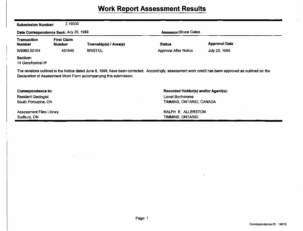
Work Report Assessment Results
Submission Number: 2.19330
Date Correspondence Sent: July 20,
Transaction NumberW9960.00104
First Claim Number
451545
1999
Township(s) 1 Area(s)BRISTOL
Assessor: Bruce Gates
StatusApproval After Notice
Approval Date
July 20, 1999
Section:14 Geophysical IP
The revisions outlined in the Notice dated June 8,1999, have been corrected. Accordingly, assessment work credit has been approved as outlined on the Declaration of Assessment Work Form accompanying this submission.
Correspondence to:Resident Geologist South Porcupine, ON
Assessment Files Library Sudbury, ON
Recorded Holder(s) and/or Agent(s):Lionel BonhommeTIMMINS, ONTARIO, CANADA
RALPH E. ALLERSTON TIMMINS, ONTARIO
Page: 1Correspondence ID: 14015
Aenoi
MAP SYMBOLOGY
Pipthn*
t ^
l *il
t H
Cliff, fi T -r T
l rv! t' ,,: l HI
4-T
.Tt l
f i
LO c k
or S worn p
Moir
Outcrop
l roa dli* J l* Tr*|k
t -
Tp 4
Rapid*
DiykK t,ft tit*' f -IJttffitt ml* mumpl* r.( 4( \ T
t Sfriom, Canal
h oo j
lowtr B Vi
Tmn*riMi*!on Lint
Turing l --jj t -utility
Whort .Doth, Pi t r
AREAS WITHDRAWN FROM PISPOSJTION
M.R.O. MINING RIGHTS ONLY
5.R.O. SURFACE-BIGHTS ONLY
M.+ i. - MINING AND SURFACE BIGHTS
Qaim N* O*T* Diipotitlan Fill
S .R.O. 164504
AHO Cj HlffNTi Wl [HUM AWN
ri *ii if Oftmo
MIMING ftNP SURFACE RIGHTS RF-OPfLNP.p ID PROSp^TlNft, STAKING (JUT, SAI-F OR UWDER Sft-T ION Art Of flit MNING AC l HA.
DATF-P 92-AU(i-bl(CLAIM NO S P-4a!S4l TO P-4Hi^4,8 WCUP-4H3333. f-1 fi 1000. P-4793D3 TQ P-4
CL. AWP P-4SD3I5 TQP-
BOHTi OlfCTiNe, •T^KNC. B*LF
ifctf TIQM li OF TKi MIHINC^0^*^*0/06 PATFP •6-M*V -Or
ANP *1WAC|F. MU CMMO MO, o-p
JJ TO*4 Of THT
P-*t*M* TO P MM7t (NO, L!
ILW AC* MOHT* PK-OPf N^P
pAtEPF
*AfJ( OH1110AT.
n JUtCTIOM 38 Of
wt
Mt*W WP iUftf ACETO
THE INFORMATION THAT APPEARS ON 1HI6 MAP HA6 BEEN COMPILED FROM VARIOUS SOURCES. AND ACCURACY (6 NOT GUARANTEED THOSE WISHING TO STAKE MIN ING CLAIMS SHOULD CON SLJLT WITH THE MINING RECORDER, MINISTRY OF NORTHERN DEVELOP MENTANP MINES, FOR AD- pITtQNAL INFORMATION ON THE STATUS OF THE LANDS 3HOWN HERf ON
58 ofACT R.* O. |iICMO, Of 30/H IfSt NtiV Of AT ^-00 Aid.
P 4WWi TOf- 4 soap net - W*
KEY PLAK For O,B M. Map
10 ir 4000 9SBOO
30 17 4500
10 IT 4KOO
tO t? 4*00
• ••da
01IOQ
GODFREV TWP.
M*GO camN1226472\ 'l UNIT5)204404
(2 UNITS) I226B40
12253392 UNITS;;.
\1226641 '
1226467
(!6 UNITS) (16 UfJ/TSJ
l J ^ - ^ __H__ i^ L — -,,—— [r- -1 r 7.1 N l .' 7 \ - : '-l ' .-'H/^ l'l,. y -. x fs UNITS) VT - '^ , -' i i ;',M vi-j.; v J"I' ^\' ,' ;- f ".*'-' - . j I'ill T 7 ' '1
—l*- f* "T ———— ~ ^.-^LX^——^-—i————H-*4 7.
235353
1190579 985BG4 X 985605H ,
^ ..^.^.-r*——-— -"-"""""7' 1 -/^ ^i- \i ~--hl/' l ^-V-^——tr-^r-1.^- -fc;^^- -i' J il F lL -75*200 i 7521 "
* '
12265*6 9815645 f 985640 \ ,, ^-- -..---... -
-——y ————— -j- ————
9B5635
,' y^;::-J ^v•( A.. *v r*,•\ . . VJ-108S764 ^.-^
'C 7 g^737
120573
•'-; ; (2~UNJ.TSl '1201162:
177305., '(.199580 'Mf 596*1 l 11596"
-j ~r^ ^" . ,, ~p , *~ '^'Tp"" ~~ —-p!-
1193477. 1 (6 UNITS l \ ' ' V
t
1159636
THORNELOE TWP.
LEGENDHIGHWAY AND ROUTh
OH. f R ROAHS
SUKVt YtO lTOWNSHIP^, BASF LINES t TLLOTS, MPNlNti LLAIM1S, PARrifLS, E 1C
UNSUflVtYEf) i INESL OT l iNFR - PARtit L BOUNDARY
fi fi AIMS F1L
ANP RlGl-tT OF WAY ^
UTILITY LINFS -
NQN PlttlNNIAL STRfAM
FLO(JI)IN(i OH F ( OOP IN Ci HICjHTS
SUBDIVISION OR COMPOSITE PLAN
ORIGINAL SHORFLINf MARSM GH MLJSKfG
DISPOSITION OF CROWN LANDS
TYPE OF DOCUMENT
PATfcNT SURFACf fc MINING RIGHT5
SURF ACL RIGHTS ONl Y ,.
.MINIMA RIGHTS ONLY .
. SURF ACF i MINING RIGHTS
. SURf-ACt HmHTSONl Y ...,
. MINING RIGHTS ONLY . ....
t OF OCCUPATION . ..
ORDER IN COUNCIL
RFSFRVATIOIY .. .
CANOFLLEO ,.. ...
SYMBOL
H Q T
OC
SAND AG , LAN& Dst PERMITNOT* MINING ftinnTS IW PAftCt LS *ATfcNTEQ r^lOR TQ WAV A
1U14. VEBTfO hH OHIGINAI ^ATENItE *V TMt ^LJ(t T l*NOS AC) HSO >ttrD CHAP 3)IQ SEC 63
Molt**tfl) c
-l l—jooo
10- - M n ,
SOD Of Hi -i , l r-
id 10 *o aa 10 /D
1000 3000 4DQO
SCALE 1:20 OOO ZONE i 17
*Pf UCAHOH KMHN9 UNOffM THE n*UC UU*P* ACT NOT1W WOUVE
TWWU
PC* CftttMN UMW UWIK TM pupuc LW*J* ACT *4-MfcM
far COIL titt-PIHM CTOHMMC ETC.,
T TO LAND USE PERMIT #M7G 40017 26 J t*
THW TWP 8UWECT TO FOREflT ACTIVITY IN 1990 /tfl. AAIAI pEHQNATED EXACTLY A* ILJiMlTrEP BY MNft TIMMINS,
TOWNSHJP
BRISTOLMN A ADMINISTRATIVE DISTRICT
TIMMINSMINING DIVISION
PORCUPINELAND TITLES/ REGISTRY DIVISION
COCHRANEMmistryof Land Natural Resources Branch
Ontario
COMPILATIONJULY laT
P ir ci.w.
JULY
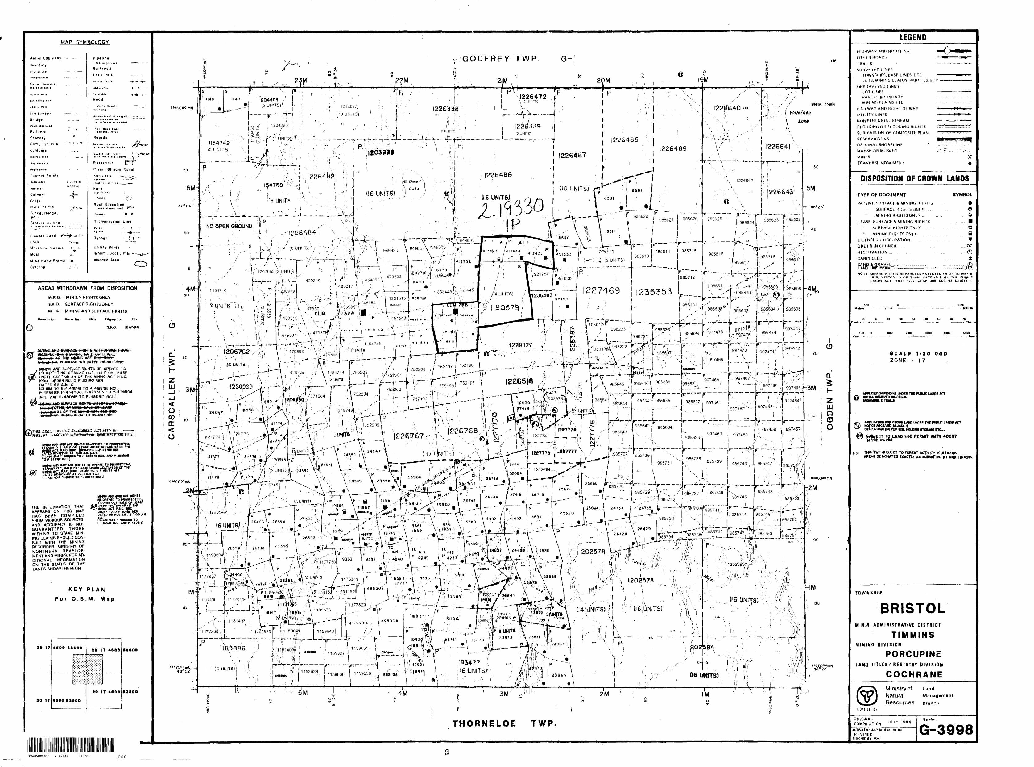
G-399842A05NE2018 2.19330 BRISTOL 200
42A05NE2018 2.19330 BRISTOL
Surveyed by TVX Ltd.
210
GRID f CLAIM MAPPROSPECTORS ALLIANCE CORPORATION
ALLERSTON OPTION Bristol Twp., Ontario
NTS 42 A/5,6 GROUND GEOPHYSICAL SURVEY Figure 2
INTERPRETATION PLAN MAP
1600E 1700E
900N-
800N-
700N —
600N-
Zone A'-SOON
Up Faulted (shallower OB)
Possible Fault Zone -Sj'^O rsj r r
v, x . j . . . . ^ - - - .
x v L "' " m ^
LEGENDCHARGEABILITY AXES
High Resistivity Association, major, minor
Nil Resistivity Association, major, minor
/ t C}T\ P* f\ ™ ^" ™ Lo* Resistivity Association, major, minor
CHARGEABILITY ANOMALIES
^ Very Strong
^ Strong
P5 Moderate
9 Weak B Questionable
— Resistivity AssociationHi
\y~
* Estimated Target Depth
High Resistivity Unit
Interpreted Fault
— Geoelectric Contact
Recommended DDH Targets
1st priority, 2nd priority
Recommended Follow-up Targets
Zone A Refer to text
Scale 1:500050 100 150 200 250 300
^^^^(meters)
PROSPECTORS ALLJANCE CORP.BRISTOL GRID
________Bristol Twp. ON_________
TIME DOMAIN IP SURVEY Gradient Array
INTERPRETATION PLAN MAPAB = 700 to 3200 meters
Transmitter Frequency 0.0625 Hz (50% duty cycle) Transmitter Current 1.4-6 Amps Decay Curve: QIP IP-6 Custom Semilogarithmic Windows
10 Gates (60ms to 5540ms)Station Interval: 20 meters
Interpretation by: JM Legault t CM Williston
Date: May, 1997Instrumentation: Rx = IRIS IP-6 (6 channels)
Tx - PHOENIX IPT-2B(15 kW) * MG-30(30 kVA)
Surveyed A Processed by:QUANTEC IP INC.DWG. j: P-188-PLAN-INT-1
42A05NE2018 2.19330 BRISTOL 220
TOTAL CHARGEABILITY (mV/V)
1600El
2600E 2700E 2800E
900N-
800N-
700N-
600N-
500N
400N
300N-
200N-
100N-
100S-
200S-
300S-
400S-
500S
600S-l l
1600E 1700E
Gradient Array ——— AB ———
r^J -'—-
-@ — .^-MN MN 1
\ ' \
50
.---.plot points
Scale 1:500050 100 150 200 250 300
(meters)
1800E 1900E 2000E 2100E 2200E 2300E 2400E 2500E 2600E 2700E 2BOOE
42A05NE2018 2.19330 BRISTOL 230
PROSPECTORS AL1JANCE CORP.BRISTOL GRID Bristol Twp . , ON
TIME DOMAIN IP SURVEY Gradient Array
TOTAL CHARGEABILITYAB= 3200 METERS
Transmitter Frequency Transmitter Current Decay Curve:
0.0625 Hz (50?? duty cycle) 5.6-6 Amps
QIP IP-6 Custom Semilogarithmic Windows 10 Gates (60ms to 3540ms)
Station Interval: 20m Chargeability Contour Interval: 0,5, 2.5 mV/V Colour Scale: Equal Area Zoning
Date: WAY 1997Instrumentation: Rx = IRIS IP-6 (6 channels)
Tx = PHOENIX IPT-2B(15 kW) + MG-30(30 kVA)
Surveyed Se Processed by:•"•"—— IP INC.DWG. #: P-188-PLAN-CHG-3
APPARENT RESISTIVITY (ohm-metres)
1600El
900N-
800N-
700N —
600N-
500N-
400N-
300N-
200N-
100N-
100S-
200S-
JOOS-
400S-
500S-
600S-
1700El
1800El
1900E 2000El
2100El
2200El
2300E l
2400E 2500El
2600E l
2700E l
2600E l
1600El
1700E
-900N
-SOON
-700N
-600N
-SOON
-400N
-300N
-200N
100N
-O
-100S
-200S
-300S
-400S
-500S
o
Gradient Array-AB-
r^-n1 MN
-®-lMN 1
50
plot points
Scale 1:500050 100 150 200 250 300
(meters)
-600S
1BOOE 1900E 2000E 21 GOE 2200E 2300E 2400E 2500E 2600E 2700E 2800E
42A05NE2018 2.19330 BRISTOL 240
PROSPECTORS ALJJANCE CORP. BRISTOL GRID
Bristol Twp., ONTIME DOMAIN IP SURVEY
Gradient Array APPARENT RESISTIVITY
AB= 3200 METERSTransmitter Frequency 0.0625 Hz (50?S duty cycle) Transmitter Current 5.6-6 Amps Decay Curve: QIP IP-6 Custom Semilogarithmic Windows
10 Gates (60ms to 3540ms)Station Interval: 20mResistivity Contour Interval: 10 levels/log decadeColour Scale: Equal Area Zoning
Date: MAY 1997Instrumentation: Rx ^ IRIS IP-6 (6 channels)
Tx ^ PHOENIX IPT-2B(15 kW) + MG-30(30 kVA)
Surveyed Se Processed by:QUANTEC IP INC.
DWG. #: P-188-PLAN-RES-3
APPARENT RESISTIVITY (ohm-metres)
CLL±J Q
0-
-100-
-200-
-300-
-400-
-500-
0 l
100Nl
200N l
300N l
400N l
SOON 600N l
700N SOON l
900N L
100N\
200N 300N 400N SOON 600Nl
700Nf
SOON
TOTAL CHARGEABILITY (mV/V)
-O
--100
--200
--300
--400
--500
900N
OmTJ
LINE 26+OOE
Gradient Array-AB-——
- r^hMN ri MN l
O-LJ Q
o-
-100-
-200-
-300-
^400-
-500-
100N l
200N l
300N l
400N l
SOON 600N l
700N SOON l
900N_L
-O
--100
-200
—300
--400
--500
Ol
100N 200N 300Nl
400N SOON SOON 700N SOON 900N
OnTD
CO O
50
plot points
Scale 1:500050 100 ISO 200 250 300a^—s
(meters)
PROSPECTORS ALLIANCE CORP.BRISTOL GRID
Bristol Twp. , ONTIME DOMAIN IP SURVEY REALSECTION L26+0
AB=700 to 3200TTSetersTransmitter Frequency 0.062 Transmitter Current Decay Curve: QIP IP-6 Custom Se
10 GateStation Interval: Resistivity Contour Interval: Chargeability Contour Interval: Colour Scale: rea Zoning
Date: MAY 1997Instrumentation: Rx = IRIS IP-6 (6 channels)
Tx - PHOENIX IPT-2B(15 kW) + MG~30(30 kVA)
Surveyed ft Processed by:QUANTEC IP INC.
DWG. #: P-188-RSIP-26+OOE42A05HE2018 2.19330 BRISTOL 250