geophysical survey offshore of dana point, california field operations report€¦ · ·...
TRANSCRIPT
GEOPHYSICAL SURVEY OFFSHORE OF
DANA POINT, CALIFORNIA
Field Operations Report
Submitted to:
State Lands Commission
100 Howe Avenue, Suite 100 South
Sacramento, CA 95825
Submitted by:
ECOSYSTEMS MANAGEMENT ASSOCIATES, INC.
2166 Avenida de la Playa, Suite E
La Jolla, CA 92037
ECO-M Reference No. 16-28
17 November 2016
Geophysical Survey Offshore of Dana Point, California
Field Operations Report
EcoSystems Management Associates, Inc. i Field Operations Report
ECO-M Reference No. 16-28
TABLE OF CONTENTS
1.0 INTRODUCTION.............................................................................................................. 1 1.1 PERMITTING: CA STATE LANDS COMMISSION ............................................................................... 2
2.0 SURVEY METHODS AND INSTRUMENTATION ..................................................... 4 2.1 GEOPHYSICAL SURVEY DATE .............................................................................................................. 4 2.2 SURVEY VESSEL ...................................................................................................................................... 4 2.3 GEOPHYSICAL SURVEY ......................................................................................................................... 4 2.4 DATA ACQUISITION AND INSTRUMENTATION ............................................................................... 5
2.4.1 GPS Positioning ....................................................................................................................................... 5 2.4.2 300 Joule Boomer system and 24-channel GeoEelTM Hydrophone streamer ........................................ 5
2.5 DATA PROCESSING.................................................................................................................................. 8 2.5.1 Data Processing ........................................................................................................................................ 8
3.0 RESULTS ........................................................................................................................... 9
LIST OF APPENDICES
Appendix A. Marine Mammal Observation Report ................................................................. A-1
Appendix B. Exhibit H ..............................................................................................................B-1
LIST OF FIGURES
Figure 1-1. Map showing location of the originally proposed geophysical survey
offshore of Dana Point, Orange County, CA ...........................................................2
Figure 2-1. High-resolution multichannel seismic equipment ...................................................6
Figure 3-1. Single-channel Q/C plot of line DNP-103 .............................................................11
Figure 3-2. A fully stacked and migrated version of line DNP-101 .........................................12
Figure A-1. Marine mammal photo observations ................................................................... A-2
LIST OF TABLES
Table 2-1. Trackline GPS coordinates for the offshore Dana Point geophysical survey
on 14 June 2016. ......................................................................................................7
Table 3-1. Field log/observers report for 18 October 2016 .....................................................13
Table A-1. Marine mammal sightings for 18 October 2016 ................................................. A-4

Geophysical Survey Offshore of Dana Point, California
Field Operations Report
EcoSystems Management Associates, Inc. 1 Technical Report
ECO-M Reference No. 16-28
GEOPHYSICAL SURVEY OFFSHORE OF
DANA POINT, CALIFORNIA
Field Operations Report
1.0 INTRODUCTION
EcoSystems Management Associates, Inc. (ECO-M), a subsidiary of Coastal
Environments (CE) conducted an offshore geophysical survey offshore of Dana Point, California
on 18 October 2016, to determine the boundaries of the offshore San Juan paleo-river channel
seaward of Doheny State Beach. Operations were conducted from the survey vessel ‘Early Bird
II’, a 2010 Armstrong marine aluminum catamaran.
The survey area occurred offshore and adjacent to San Juan Creek in Dana Point,
California. The survey was conducted from just beyond the surf zone to about 9000 feet (ft) (1.5
miles) offshore and approximately 8300 ft (1.4 miles) alongshore and imaged the sub-bottom
geology to depths exceeding 200 feet. The survey completed 14 transect lines (Figure 1-1).
Equipment included the following:
1. 300 Joule Boomer system, including the Boomer Control Box and towed sonographic
delivery system;
2. Geometric CNT-2 controller data-acquisition system with nominal 240-channel
recording capability;
3. 24-channel, high-resolution GeoEelTM digital streamer hydrophone array;
4. Trimble GPS antenna and differential GPS receiver.
The data were acquired with a 300-joule “boomer” acoustic source towed at a depth of
0.3-m (1-ft) below the sea surface. A 24-channel GeoEel™ high-resolution digital streamer with
a group interval of 1.56-m (5.12-ft) recorded the reflected acoustic wave energy at a sampling
interval of 0.25-ms for a record length of 1000 samples equal to 0.25 sec (250-ms). Common
Depth Point (CDP) processing will be applied to the data to provide digital seismic images for
interpretation on a workstation using the Geographix™ software.

Geophysical Survey Offshore of Dana Point, California
Field Operations Report
EcoSystems Management Associates, Inc. 2 Technical Report
ECO-M Reference No. 16-28
1.1 PERMITTING: CA STATE LANDS COMMISSION
Prior to the geophysical survey work, ECO-M acquired the necessary permit from the
California State Lands Commission (Permit # PRC 8536.9). As per permit requirements, a
Marine Wildlife Contingency Plan was prepared and a marine mammal observer was present
during the surveys to assure that marine mammals were not harmed by the low energy sonic
pulses generated by the geophysical survey equipment. Mammal observations that were carried
out during the surveys determined when survey activities should be altered or stopped to avoid
interaction with marine mammals. A copy of the Marine Mammal Observer Report during the
survey (18 October 2016) is in Appendix A. Additionally, all parties identified in Exhibit C of
the permit were sent notification of the geophysical survey activity.

Geophysical Survey Offshore of Dana Point, California
Field Operations Report
EcoSystems Management Associates, Inc. 3 Technical Report
ECO-M Reference No. 16-28
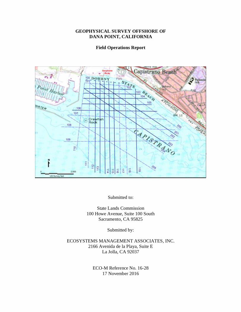
Figure 1-1. Map showing location of the geophysical survey offshore of Dana Point,
Orange County, CA. A nautical chart serves as a background map, and shows
the full area of coverage. The solid lines indicate the 14 survey lines completed.
The orange lines indicate lines conducted during the previous survey on June
14, 2016.
Geophysical Survey Offshore of Dana Point, California
Field Operations Report
EcoSystems Management Associates, Inc. 4 Technical Report
ECO-M Reference No. 16-28
2.0 SURVEY METHODS AND INSTRUMENTATION
2.1 GEOPHYSICAL SURVEY DATE
The survey was conducted on October 18th 2016 to determine the boundaries of the
offshore San Juan paleo-river channel seaward of Doheny State Beach.
2.2 SURVEY VESSEL
Operations were conducted from the survey vessel ‘Early Bird II’, a 2010 Armstrong
marine aluminum catamaran. The vessel was equipped with the following primary equipment for
execution of the survey:
1. 300 Joule Boomer system, including the Boomer Control Box and towed sonographic
delivery system;
2. Geometric CNT-2 controller data-acquisition system with nominal 240-channel
recording capability;
3. 24-channel, high-resolution GeoEelTM digital streamer hydrophone array; Trimble
GPS antenna and differential GPS receiver.
2.3 GEOPHYSICAL SURVEY
The survey conducted on the afternoon of October 18, 2016, covered the area from
beyond the surf zone to about 9000 feet offshore and imaged the sub-bottom geology to depths
exceeding 200 feet. We recorded the seismic reflection data to at least 200 milliseconds two-way
travel time. Because seismic reflection profiling measures the subsurface geological reflections
in time (two-way travel time – down and back), it is necessary to have information on the sub-
bottom seismic velocity. Multichannel seismic profiling obtains that information from the
differential travel times to the offset hydrophone groups in the streamer. The seismic velocity
structure is also useful for interpreting lithology. Geological ground truth from wells or
boreholes is still required, however, to confirm interpretation of subsurface geology from seismic
images.
Some profiles consist of multiple pieces (2) because of interruptions requiring course
changes due to heavy swell. The data were acquired with a 300-joule “boomer” acoustic source
towed at a depth of 0.3-m (1-ft) below the sea surface. A 24-channel GeoEel™ high-resolution
digital streamer with a group interval of 1.56-m (5.12-ft) recorded the reflected acoustic wave
energy at a sampling interval of 0.25-ms for a record length of 1000 samples equal to 0.25 sec
(250-ms). Common Depth Point (CDP) processing will be applied to the data to provide digital
seismic images for interpretation on a workstation using the Geographix™ software. Both
stacked and migrated seismic profiles will be produced for interpretation.

Geophysical Survey Offshore of Dana Point, California
Field Operations Report
EcoSystems Management Associates, Inc. 5 Technical Report
ECO-M Reference No. 16-28
Data quality was established in the field during acquisition by monitoring data being
recorded by the digital data acquisition system and by preliminary seismic data processing
aboard the boat (Profiles DNP-101 and DNP-103). The software used for digital recording of the
seismic reflection trace data allow display of shot records and some quantitative measures of
acoustic signal and noise levels. The Vista™ seismic data processing software was also used on
a laptop computer in the field to examine shot records and perform preliminary data processing,
including brute stacking (DNP-101), to insure that data are suitable for interpretation to the target
depths and cover the area of interest. Single-channel monitor records from the data acquisition
system (DNP-103) were also prepared to show data quality and allow preliminary geological
interpretation so that any prominent subsurface features identified may be specifically targeted in
subsequent tracklines, including extension of the line if necessary. Once underway, it is easy to
extend a line for a few hundred feet at minimal cost in time and effort.
2.4 DATA ACQUISITION AND INSTRUMENTATION
2.4.1 GPS Positioning
A differential Global Positioning Satellite (GPS) navigation system was used to record
the shot points at precisely one-second intervals during acquisition. The differential system used
ties to the Coast Guard maintained permanent GPS base station in the area. Nominal GPS
position accuracy is about 10 meters, and with differential technique, we achieved sub-meter
position accuracy (< 3-ft). The shot point navigation (geographic coordinates) during acquisition
was based upon the World Geodetic System of 1984 (WGS84) and were converted to the
California State Plane Coordinate System, zone 6, North American Datum of 1983 (NAD83), in
feet. Shot point positions were determined by adding corrections for the layback or acoustic
source distance behind the GPS antenna on the boat
2.4.2 300 Joule Boomer system and 24-channel GeoEelTM Hydrophone streamer
The profiling system consisted of a 300-joule boomer acoustic source and a 24-channel
GeoEel hydrophone streamer with group interval of 1.56-m (5-ft). The multichannel system is
shown in Figure 2-1. The boomer source is capable of producing acoustic energy pulses with
frequency bandwidth up to about 1,000-Hz, but considering spatial aliasing due to back-scattered
acoustic energy in the water column, it normally provides useful bandwidth to about 500-Hz
with a short streamer group interval. The final processed seismic profiles were filtered to a
bandwidth of 72-640 Hz. At a typical compressional wave velocity in water-saturated sediments
of about 1,520 m/s (5,000 ft/s), the sub-bottom resolution achieved is about 1.5-m (5-ft) for half
wavelength events or about 0.6-m (2-ft) considering “tuning” effects.

Geophysical Survey Offshore of Dana Point, California
Field Operations Report
EcoSystems Management Associates, Inc. 6 Technical Report
ECO-M Reference No. 16-28
Figure 2-1. High-resolution multichannel seismic equipment: Above left is the 300-Joule
Boomer in Tow; Above Right is the 16-channel GeoEel digital mini-
streamer (24-channel version proposed effort). Below is a view of the
equipment deployed for a survey offshore Santa Cruz, California. The
boomer sled is in the mid-foreground and the streamer tail buoy is the white
object in the right center.

Geophysical Survey Offshore of Dana Point, California
Field Operations Report
EcoSystems Management Associates, Inc. 7 Technical Report
ECO-M Reference No. 16-28
Table 2-1. Trackline GPS coordinates for the offshore Dana Point geophysical survey on 18
October 2016
# Date Line Lat Start Long Start Lat End Lat End
1 10/18/2016 DNP104 33.458002 117.68876 33.45815 117.675975
2 10/18/2016 DNP105 33.457099 117.689027 33.457105 117.675009
3 10/18/2016 DNP106 33.456002 117.690978 33.455997 117.673909
4 10/18/2016 DNP107 33.455174 117.691879 33.454671 117.671945
5 10/18/2016 DNP112 33.461108 117.686351 33.445531 117.686235
6 10/18/2016 DNP113 33.461057 117.685456 33.445415 117.6852
7 10/18/2016 DNP115 33.460649 117.681651 33.445372 117.681085
8 10/18/2016 DNP117 33.460504 117.680439 33.4453 117.67973
9 10/18/2016 DNP118 33.459756 117.678303 33.445468 117.677741
10 10/18/2016 DNP119 33.46053 117.685542 33.451855 117.669667
11 10/18/2016 DNP200 33.460602 117.687561 33.451321 117.670521
12 10/18/2016 DNP201 33.458121 117.68862 33.448864 117.672446
13 10/18/2016 DNP204 33.455074 117.691897 33.445944 117.674063
14 10/18/2016 DNP999 33.453084 117.694873 33.440887 117.675794

Geophysical Survey Offshore of Dana Point, California
Field Operations Report
EcoSystems Management Associates, Inc. 8 Technical Report
ECO-M Reference No. 16-28
2.5 DATA PROCESSING
2.5.1 Data Processing
Data processing was based on the Common-Depth-Point (CDP) wavelet processing
method using the commercial seismic data processing program Vista™ (vers. 10) for 2-D
seismic reflection data. Processing steps included: trace editing to remove spikes, band-pass
filtering to avoid aliasing, spiking deconvolution to shape the zero-phase wavelet, spherical
divergence correction to account for wavefront spreading, trace scaling to account for source
variability, normal-moveout (NMO) correction using a stacking velocity of 5,000 ft/s, stacking
sorted CDP records, and FK migration at 4,800 ft/s to sharpen the image. Static corrections were
applied to account for depth of acoustic source and streamer, and remove the tidal elevation. For
shallow subsurface marine seismic data, brute stacks at a constant velocity of 5,000 ft/sec
provided good seismic images. Velocity analysis at several locations along key profiles (lines
104 and 203) were performed to provide more seismic velocity structure needed for time-to-
depth conversion. The results of the velocity analysis showed that a constant velocity of 5,000
ft/sec (1,520 m/s) was valid for stacking the data at the shallow depths of interest. Post-stack
migration of the seismic data using the frequency-wave number method with a constant velocity
of 4,800 ft/sec (1,463 m/s) provided a sharper image of subsurface structure by collapsing
diffractions and moving dipping reflectors to more accurate positions. The processed seismic
data products include both stacked and migrated SEG-Y format data files that were loaded into
the workstation for interpretation. Printed copies of seismic profiles saved as pdf files were used
for quality control during processing and for plots in the survey report.

Geophysical Survey Offshore of Dana Point, California
Field Operations Report
EcoSystems Management Associates, Inc. 9 Technical Report
ECO-M Reference No. 16-28
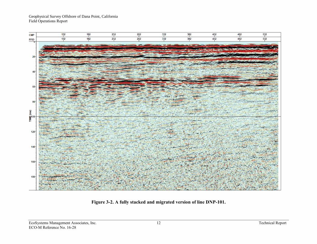
3.0 RESULTS
The results of the seismic profiles for selected transects are shown in Figures 3-1 through
3-3. Daily field logs are found in Tables 3-1 and 3-2. Profile DNP-103 is a single-channel
monitor record that shows the data quality achieved in the field without any data processing
except for band-pass filtering. Profile DNP-101 is a “Brute” stack of the data using the CDP data
processing method and shows excellent data quality to almost 200-ms two-way travel time (>
500 feet subsea). A strong reflective sequence exists at about 50-ms two-way travel time (about
125-150 feet subsea).

Geophysical Survey Offshore of Dana Point, California
Field Operations Report
EcoSystems Management Associates, Inc. 11 Technical Report
ECO-M Reference No. 16-28
Figure 3-1. Single-channel Q/C plot of line DNP-103.
Geophysical Survey Offshore of Dana Point, California
Field Operations Report
EcoSystems Management Associates, Inc. 12 Technical Report
ECO-M Reference No. 16-28
Figure 3-2. A fully stacked and migrated version of line DNP-101.

Geophysical Survey Offshore of Dana Point, California
Field Operations Report
EcoSystems Management Associates, Inc. A-1 Technical Report Technical Report
ECO-M Reference No. 16-28
APPENDIX A
MARINE MAMMAL OBSERVER REPORT

Geophysical Survey Offshore of Dana Point, California
Field Operations Report
EcoSystems Management Associates, Inc. A-2 Technical Report Technical Report
ECO-M Reference No. 16-28
MARINE MAMMAL OBSERVATION REPORT
SAN LUIS RAY GEOPHYSICAL SURVEY
DANA POINT, CALIFORNIA
Vessel: R/V Early Bird II
Captains: Ken Nielsen, Bob Lohrman
Scientific crew: Mark Legg, Doug Bowlus, James Peeler, Ryan Switzer, Brian Villalobos
Marine Mammal Observer: Chris Castillo
Dates of survey: Oct 18 2016
A geophysical survey offshore of Dana Point, California was conducted in order to
determine the boundaries of the offshore San Juan paleo-river channel seaward of Doheny State
Beach. The acoustic source consisted of a small 300-joule boomer similar to sources used by the
U.S. Geological Survey. A 24-channel high-resolution digital streamer hydrophone array will be
used to collect signals returning from the seafloor to improve the signal quality and attenuate the
water bottom multiple, a 24-channel high-resolution digital streamer hydrophone array will be
used to collect signals returning from the seafloor. The survey was conducted from just beyond the
surf zone to about 9000 feet (ft) (1.5 miles) offshore and approximately 8300 ft (1.4 miles)
alongshore.
The study required the use of sound producing instrumentation, requiring the presence of a
marine mammal observer (MMO). The echo-sounder emits a low-frequency pulse of 200-800 Hz
at 0.78-sec intervals, towed at a distance of 20-m from the vessel. The hydrophone streamer
contained an array of 25 hydrophones, extending 40-m from the vessel. Two types of acquisition
were preformed, high resolution reflection profiles utilizing 24 channel streamer and a source rep-
rate of 0.78 seconds. The energy source was operated at 300 joules so impact on marine was
minimal. Lower resolution profiles were collected on shore-perpendicular transects at 1 sec source
rep-rate. These acoustic sources were recorded on land by a Geometrics Geode 72 channel
recorder. A pre-watch duration of 20 minutes and an exclusion zone 0f 100 m radius for non-
shutdown species, and 500m for protected species from the acoustic source of were set as the
parameters for operation of the echo-sounder.
Fourteen transect lines were surveyed along the coastline of Dana Point, including the area
south of the mouth of San Juan Creek. Marine mammals most likely to be encountered in the near-
shore area were California sea lions (Zalophus californianus,) Harbor seals (Phoca vitulina,)
Bottlenose dolphin (Tursiops truncates,) Common dolphin (Delphinus spp.,) and Gray whales
(Eschrichtius robustus) and Humpback Whales (Megaptera novaeangliae). A harbor seal was
visible during the pre-watch requiring us to delay the start of ramp up. No sightings of cetaceans
occurred during the survey, as whale has just begun for the 2016 season, and the whales are still
far north. Four harbor seals sightings occurred, but no signs of distress were observed and there
was cause for a shut-down. One possible sighting of a Harbor Seal occurred during operation of
the acoustic source, but the sighting was not confirmed.
The results of the Marine Mammal Observer report are described below. Daily field log
reports are found in Table A-1.

Geophysical Survey Offshore of Dana Point, California
Field Operations Report
EcoSystems Management Associates, Inc. A-3 Technical Report Technical Report
ECO-M Reference No. 16-28
Survey Date: 18 October 2016
Conditions: clear skies; 66° F; wind 5-10 knots from the NE; swell 0.5; Beaufort 1
Time Observation/ Vessel Activity
08:00 Leave dock, prewatch started
08:30 Harbor seal fin and tail observed while in transit to deployment location 20 m off bow
of vessel.
09:06 Pre-watch complete.
09:19 Ramp-up of acoustic source.
09:26 Harbor seal observed resting on red buoy at harbor entrance, Photo 1A
09:29 Ramp-up complete
09:36 Start of Line 204
09:41 End of Line 204
09:56 Start of Line 104
09:58 End of Line 104
10:07 Start of Line 106
10:11 End of Line 106
10:23 Start of Line 107
10:25 Paddle boarder crossing streamer
10:26 Fast boat crossing near streamer
10:30 End of Line 107
10:39 Start of Line 200
10:44 End of Line 200
10:55 Leave dock, prewatch started

Geophysical Survey Offshore of Dana Point, California
Field Operations Report
EcoSystems Management Associates, Inc. A-3 Technical Report Technical Report
ECO-M Reference No. 16-28
Conditions: clear skies; 68° F; wind 0-5 knots from the sw; swell ~3’ @ 13s; Beaufort 1
Time Observation/ Vessel Activity
10:59 Start of Line 117
11:01 End of Line 117 due to error
11:10 Start of Line 119
11:13 Possible sea lion spotted 50 m away from starboard bow. Dove underwater.
11:23 End of Line 119
11:25 Start of Line 118
11:39 End of Line 118
11:41 Start of Line 117
11:55 End of Line 117
12:00 Start of Line 112
12:13 End of Line 112
12:14 Start of Line 201
12:28 End of Line 201
12:37 Start of Line 105
12:50 End of Line 105
12:55 Start of Line 999
13:00 End of Line 999
13:08 Start of Line 113
13:21 End of Line 113
13:23 Start of Line 115
13:25 Trouble with Applied Acoustics CSP2, begin troubleshooting
15:18 One harbor seal observed resting on buoy near harbor entrance (Photo 1B), possibly the
same one observed during the morning (Photo 1A)
15:20 Return to dock
16:30 Conclude to demobilize

Geophysical Survey Offshore of Dana Point, California
Field Operations Report
EcoSystems Management Associates, Inc. A-4 Technical Report Technical Report
ECO-M Reference No. 16-28
Figure A-1. Marine mammal photo observations
A 09:29 B 15:18

Geophysical Survey Offshore of Dana Point, California
Field Operations Report
EcoSystems Management Associates, Inc. A-5 Technical Report
ECO-M Reference No. 16-28
Table A-1. Marine mammal sightings for 14 June 2016.
Sighting
No.
Time
(PDT) Bearing
Dist. From
Source (m)
Vessel
Activity Species
No. of
Animals
Observed
Direction of
Travel Behavior
1 09:06 035 30 Pre-watch Harbor Seal 1 035
Harbor seal ahead of vessel,
surfaced then submerged. Photo
1A
2 09:29 - 40 Ramp Up Harbor Seal 1 Stationary Harbor seal resting on buoy near
harbor entrance
3 11:13 105 50 Acquiring Harbor Seal 1 ? Sighting not confirmed
4 15:18 - 30 Shutdown Harbor Seal 1 N
Two harbor seals now resting on
buoy near harbor entrance.
Photo 1B

Geophysical Survey Offshore of Dana Point, California
Field Operations Report
EcoSystems Management Associates, Inc. B-1 Technical
Report Technical Report
ECO-M Reference No. 16-28
APPENDIX B
EXHIBIT H

Geophysical Survey Offshore of Dana Point, California
Field Operations Report
EcoSystems Management Associates, Inc. B-2 Technical Report
ECO-M Reference No. 16-28
EXHIBIT H 1
Mitigation Monitoring Program 2 3
Mitigation
Measure (MM) Location and Scope of Mitigation
Effectiveness
Criteria
Monitoring or
Reporting Action
Responsible
Party Timing
Implementation
Date(s) and
Initials
Air Quality and Greenhouse Gas (GHG) Emissions (MND Section 3.3.3) MM AIR-1:
Engine Tuning,
Engine
Certification, and
Fuels. The
following measures
will be required to be implemented by
all Permittees
under the Offshore
Geophysical Permit
Program (OGPP),
as applicable
depending on the
county offshore
which a survey is
being conducted.
Pursuant to section
93118.5 of
CARB’s Airborne
Toxic Control
Measures, the Tier
2 engine
requirement applies
only to diesel-
fueled vessels.
All Counties: Maintain all construction equipment in
proper tune according to manufacturers’ specifications;
fuel all off-road and portable diesel-powered equipment
with California Air Resources Board (CARB)-certified
motor vehicle diesel fuel limiting sulfur content to 15 parts
per million or less (CARB Diesel).
Daily emissions
of criteria
pollutants during
survey activities
are minimized.
Determine engine
certification of vessel
engines. Review engine
emissions data to assess
compliance, determine
if changes in tuning or
fuel are required.
OGPP permit
holder and
contract vessel
operator;
California State
Lands
Commission (CSLC) review
of Final
Monitoring
Report.
Prior to,
during, and
after survey
activities.
Submit
Final
Monitoring Report after
completion
of survey
activities.
N/A- exempt-
gasoline vessel
Los Angeles and Orange Counties: Use vessel engines
meeting CARB’s Tier 2-certified engines or cleaner; the
survey shall be operated such that daily NOx emissions do
not exceed 100 pounds based on engine certification
emission factors. This can be accomplished with Tier 2
engines if daily fuel use is 585 gallons or less, and with
Tier 3 engines if daily fuel use is 935 gallons or less
Verify that Tier 2 or
cleaner engines are
being used. Calculate
daily NOx emissions to
verify compliance with
limitations.
N/A- exempt-
gasoline vessel
San Luis Obispo County: Use vessel engines meeting
CARB’s Tier 2-certified engines or cleaner, accomplished
with Tier 2 engines if daily fuel use is 585 gallons or less;
all diesel equipment shall not idle for more than 5 minutes;
engine use needed to maintain position in the water is not
considered idling; diesel idling within 300 meters (1,000
feet) of sensitive receptors is not permitted; use
alternatively fueled construction equipment on site where
feasible, such as compressed natural gas, liquefied natural
gas, propane or biodiesel.
Verify that Tier 2 or
cleaner engines are
being used. Inform
vessel operator(s) of
idling limitation.
Investigate availability
of alternative fuels
N/A- exempt-
gasoline vessel
Santa Barbara County: Use vessel engines meeting
CARB’s Tier 2-certified engines or cleaner, accomplished
with Tier 2 engines if daily fuel use is 790 gallons or less.
Verify that Tier 2 or
cleaner engines are
being used. Investigate
availability of
alternative fuels
N/A- exempt-
gasoline vessel
Ventura County: Use alternatively fueled construction
equipment on site where feasible, such as compressed
natural gas, liquefied natural gas, propane or biodiesel.
Investigate availability
of alternative fuels. N/A- exempt-
gasoline vessel

Geophysical Survey Offshore of Dana Point, California
Field Operations Report
EcoSystems Management Associates, Inc. B-3 Technical Report
ECO-M Reference No. 16-28
Mitigation
Measure (MM) Location and Scope of Mitigation
Effectiveness
Criteria
Monitoring or
Reporting Action
Responsible
Party Timing
Implementatio
n Date(s) &
Initials MM BIO-1:
Marine Mammal
and Sea Turtle
Presence – Current
Information.
All State waters; prior to commencement of survey
operations, the geophysical operator shall: (1) contact the
National Oceanic and Atmospheric Administration Long
Beach office staff and local whale-watching operations
and shall acquire information on the current composition
and relative abundance of marine wildlife offshore, and (2)
convey sightings data to the vessel operator and crew,
survey party chief, and onboard Marine Wildlife Monitors (MWMs) prior to departure. This information will aid the
MWMs by providing data on the approximate number and
types of organisms that may be in the area.
No adverse
effects to marine
mammals or sea
turtles due to
survey activities
are observed.
Document contact with
appropriate sources.
Submit Final
Monitoring Report after
completion of survey
activities.
OGPP permit
holder; Inquiry
to NOAA and
local whale
watching
operators.
Prior to
Survey
EC 5/27/16
MM BIO-2:
Marine Wildlife
Monitors
(MWMs).
Except as provided in section 7(h) of the General Permit, a
minimum of two (2) qualified MWMs who are
experienced in marine wildlife observations shall be
onboard the survey vessel throughout both transit and data
collection activities. The specific monitoring, observation,
and data collection responsibilities shall be identified in
the Marine Wildlife Contingency Plan required as part of
all Offshore Geophysical Permit Program permits.
Qualifications of proposed MWMs shall be submitted to
the National Oceanic and Atmospheric Administration
(NOAA) and CSLC at least twenty-one (21) days in
advance of the survey for their approval by the agencies.
Survey operations shall not commence until the CSLC
approves the MWMs.
Competent and
professional
monitoring or
marine mammals
and sea turtles;
compliance with
established
monitoring
policies.
Document contact with
and approval by
appropriate agencies.
Submit Final
Monitoring Report after
completion of survey
activities.
OGPP permit
holder.
Prior to
survey.
EC 5/27/16

Geophysical Survey Offshore of Dana Point, California
Field Operations Report
EcoSystems Management Associates, Inc. B-4 Technical Report
ECO-M Reference No. 16-28
Mitigation
Measure (MM) Location and Scope of Mitigation
Effectiveness
Criteria
Monitoring or
Reporting Action
Responsible
Party Timing
Implementatio
n Date(s) &
Initials MM BIO-3:
Safety Zone
Monitoring.
Onboard Marine Wildlife Monitors (MWMs) responsible
for observations during vessel transit shall be responsible
for monitoring during the survey equipment operations. All
visual monitoring shall occur from the highest practical
vantage point aboard the survey vessel; binoculars shall be
used to observe the surrounding area, as appropriate. The
MWMs will survey an area (i.e., safety or exclusion zone)
based on the equipment used, centered on the sound source (i.e., vessel, towfish), throughout time that the survey
equipment is operating. Safety zone radial distances, by
equipment type, include:
Equipment Type Safety
Zone (radius, m)
Equipment Type Safety
Zone (radius, m)
Single Beam Echosounder 50
Multibeam Echosounder 500
Side-Scan Sonar 600
Subbottom Profiler 100
Boomer System 100
If the geophysical survey equipment is operated at or above
a frequency of 200 kilohertz (kHz), safety zone monitoring
and enforcement is not required; however, if geophysical
survey equipment operated at a frequency at or above 200
kHz is used simultaneously with geophysical survey
equipment less than 200 kHz, then the safety zone for the
equipment less than 200 kHz must be monitored. The
onboard MWMs shall have authority to stop operations if a
mammal or turtle is observed within the specified safety
zone and may be negatively affected by survey activities.
The MWMs shall also have authority to recommend
continuation (or cessation) of operations during periods of
limited visibility (i.e., fog, rain) based on the observed abundance of marine wildlife.
No adverse
effects to marine
mammals or sea
turtles due to
survey activities
are observed;
compliance with
established safety zones.
Compliance with
permit requirements
(observers); compliance
with established safety
zones. Submit Final
Monitoring Report after
completion of survey
activities.
OGPP permit
holder.
Prior to
survey.
CC 6/14/16

Geophysical Survey Offshore of Dana Point, California
Field Operations Report
EcoSystems Management Associates, Inc. B-5 Technical Report
ECO-M Reference No. 16-28
Mitigation
Measure (MM) Location and Scope of Mitigation
Effectiveness
Criteria
Monitoring or
Reporting Action
Responsible
Party Timing
Implementatio
n Date(s) &
Initials MM BIO-3:
Safety Zone
Monitoring.
Periodic reevaluation of weather conditions and
reassessment of the continuation/cessation
recommendation shall be completed by the onboard
MWMs. During operations, if an animal’s actions are
observed to be irregular, the monitor shall have authority
to recommend that equipment be shut down until the
animal moves further away from the sound source. If
irregular behavior is observed, the equipment shall be shut-off and will be restarted and ramped-up to full power,
as applicable, or will not be started until the animal(s)
is/are outside of the safety zone or have not been observed
for 15 minutes. For nearshore survey operations utilizing
vessels that lack the personnel capacity to hold two (2)
MWMs aboard during survey operations, at least twenty-
one (21) days prior to the commencement of survey
activities, the Permittee may petition the CSLC to conduct
survey operations with one (1) MWM aboard. The CSLC
will consider such authorization on a case-by-case basis
and factors the CSLC will consider will include the timing,
type, and location of the survey, the size of the vessel, and
the availability of alternate vessels for conducting the
proposed survey. CSLC authorizations under this
subsection will be limited to individual surveys and under
any such authorization; the Permittee shall update the
MWCP to reflect how survey operations will occur under
the authorization.
No adverse
effects to marine
mammals or sea
turtles due to
survey activities
are observed;
compliance with
established safety zones.
Compliance with
permit requirements
(observers); compliance
with established safety
zones. Submit Final
Monitoring Report after
completion of survey
activities.
OGPP permit
holder.
Prior to
survey.
CC 6/14/16

Geophysical Survey Offshore of Dana Point, California
Field Operations Report
EcoSystems Management Associates, Inc. B-6 Technical Report
ECO-M Reference No. 16-28
Mitigation
Measure (MM) Location and Scope of Mitigation
Effectiveness
Criteria
Monitoring or
Reporting Action
Responsible
Party Timing
Implementatio
n Date(s) &
Initials MM BIO-4:
Limits on
Nighttime OGPP
Surveys.
All State waters; nighttime survey operations are
prohibited under the OGPP, except as provided below. The
CSLC will consider the use of single beam echosounders
and passive equipment types at night on a case-by-case
basis, taking into consideration the equipment
specifications, location, timing, and duration of survey
activity.
No adverse
effects to marine
mammals or sea
turtles due to
survey activities
are observed.
Presurvey request for
nighttime operations,
including equipment
specifications and
proposed use schedule.
Document equipment
use. Submit Final
Monitoring Report after completion of survey
activities
OGPP permit
holder.
Approval
required
before
survey is
initiated.
Monitoring
Report
following completion
of survey.
CC 6/14/16
MM BIO-5: Soft
Start.
All State waters; the survey operator shall use a “soft start”
technique at the beginning of survey activities each day (or
following a shut down) to allow any marine mammal that
may be in the immediate area to leave before the sound
sources reach full energy. Surveys shall not commence at
nighttime or when the safety zone cannot be effectively
monitored. Operators shall initiate each piece of
equipment at the lowest practical sound level, increasing
output in such a manner as to increase in steps not
exceeding approximately 6 decibels (dB) per 5- minute
period. During ramp-up, the Marine Wildlife Monitors
(MWMs) shall monitor the safety zone. If marine
mammals are sighted within or about to enter the safety
zone, a power-down or shut down shall be implemented as
though the equipment was operating at full power.
Initiation of ramp-up procedures from shut down requires
that the MWMs be able to visually observe the full safety
zone.
No adverse
effects to marine
mammals or sea
turtles due to
survey activities
are observed.
Compliance with
permit requirements
(observers); compliance
with safe start
procedures. Submit
Final Monitoring
Report after completion
of survey activities.
OGPP permit
holder.
Immediately
prior to
survey.
TN 06/14/16

Geophysical Survey Offshore of Dana Point, California
Field Operations Report
EcoSystems Management Associates, Inc. B-7 Technical Report
ECO-M Reference No. 16-28
Mitigation
Measure (MM) Location and Scope of Mitigation
Effectiveness
Criteria
Monitoring or
Reporting Action
Responsible
Party Timing
Implementatio
n Date(s) &
Initials MM BIO-6:
Practical
Limitations on
Equipment Use and
Adherence to
Equipment
Manufacturer’s
Routine Maintenance
Schedule.
All State waters; geophysical operators shall follow, to the
maximum extent possible, the guidelines of Zykov (2013)
as they pertain to the use of subbottom profilers and
sidescan sonar, including: Using the highest frequency
band possible for the subbottom profiler; Using the
shortest possible pulse length; and Lowering the pulse rate (pings per second) as much as feasible. Geophysical
operators shall consider the potential applicability of these
measures to other equipment types (e.g., boomer). Permit
holders will conduct routine inspection and maintenance
of acoustic-generating equipment to ensure that low energy geophysical equipment used during permitted
survey activities remains in proper working order and
within manufacturer’s equipment specifications.
Verification of the date and occurrence of such equipment
inspection and maintenance shall be provided in the
required presurvey notification to CSLC.
No adverse
effects to marine
mammals or sea
turtles due to
survey activities
are observed.
Document initial and
during survey
equipment settings.
Submit Final
Monitoring Report after
completion of survey
activities.
OGPP permit
holder.
Immediately
prior to and
during
survey.
HW 5/28/16
MM BIO-7:
Avoidance of
Pinniped Haul-Out
Sites.
The Marine Wildlife Contingency Plan (MWCP)
developed and implemented for each survey shall include
identification of haul-out sites within or immediately
adjacent to the proposed survey area. For surveys within
300 meters (m) of a haul-out site, the MWCP shall further
require that:
The survey vessel shall not approach within 91 m of a haul-out site, consistent with National Marine Fisheries
Service (NMFS) guidelines;
Survey activity close to haul-out sites shall be conducted in an expedited manner to minimize the potential for
disturbance of pinnipeds on land; and
Marine Wildlife Monitors shall monitor pinniped activity onshore as the vessel approaches, observing and
reporting on the number of pinnipeds potentially disturbed
(e.g., via head lifting, flushing into the water). The purpose
of such reporting is to provide CSLC and California
Department of Fish and Wildlife (CDFW) with
information regarding potential
No adverse
effects to
pinnipeds at haul
outs are observed.
Document pinniped
reactions to vessel
presence and
equipment use. Submit
Final Monitoring
Report after completion
of survey activities.
OGPP permit
holder.
Monitoring
Report
following
completion
of survey
CC 6/14/16

Geophysical Survey Offshore of Dana Point, California
Field Operations Report
EcoSystems Management Associates, Inc. B- 8 Technical Report
ECO-M Reference No. 16-28
Mitigation
Measure (MM) Location and Scope of Mitigation
Effectiveness
Criteria
Monitoring or
Reporting Action
Responsible
Party Timing
Implementatio
n Date(s) &
Initials MM BIO-8:
Reporting
Requirements –
Collision.
All State waters; if a collision with marine mammal or
reptile occurs, the vessel operator shall document the
conditions under which the accident occurred, describing:
Vessel location (lat., long.) when collision occurred;
Date and time of collision;
Speed and heading of the vessel at the time of collision;
Observation conditions (e.g., wind speed & direction, swell height, visibility in miles or kilometers, and presence
of rain or fog) at time of collision;
Species of marine wildlife contacted (if known);
If an MWM or MMO was onboard;
Vessel name, vessel owner/operator, & captain officer in charge of the vessel at time of collision. After a
collision, the vessel shall stop, if safe to do so; however,
the vessel is not obligated to stand by and may proceed after confirming that it will not further damage the animal
by doing so. The vessel must immediately communicate
by radio or telephone all details to the vessel’s base of
operations, and shall report the incident. Consistent with
Marine Mammal Protection Act requirements, the vessel’s
base of operations or, if an onboard telephone is available,
the vessel captain him/herself, will then immediately call
the National Oceanic and Atmospheric Administration
(NOAA) Stranding Coordinator to report the collision and
follow any subsequent instructions. From the report, the
Stranding Coordinator will coordinate subsequent action,
including enlisting the aid of marine mammal rescue
organizations, if appropriate. From the vessel’s base of
operations, a telephone call will be placed to the Stranding
Coordinator, NOAA National Marine Fisheries Service
(NMFS), Southwest Region, Long Beach, to obtain
instructions. Although NOAA has primary responsibility
for marine mammals in both State and Federal waters, the
California Department of Fish and Wildlife (CDFW) will
also be advised that an incident has occurred in State
waters affecting a protected species.
No adverse
effects to marine
mammals or sea
turtles due to
survey activities
are observed.
Submit Final
Monitoring Report after
completion of survey
activities.
OGPP permit
holder.
Monitoring
Report
following
completion
of survey.
N/A No
Collisions
Reported
06/14/16

Geophysical Survey Offshore of Dana Point, California
Field Operations Report
EcoSystems Management Associates, Inc. B- 9 Technical Report
ECO-M Reference No. 16-28
Mitigation
Measure (MM) Location and Scope of Mitigation
Effectiveness
Criteria
Monitoring or
Reporting Action
Responsible
Party Timing
Implementatio
n Date(s) &
Initials MM BIO-9:
Limitations on
Survey Operations
in Select Marine
Protected Areas
(MPAs).
All MPAs; prior to commencing survey activities,
geophysical operators shall coordinate with the CLSC,
California Department of Fish and Wildlife (CDFW), and
any other appropriate permitting agency regarding
proposed operations within MPAs. The scope and purpose
of each survey proposed within a MPA shall be defined by
the permit holder, and the applicability of the survey to the
allowable MPA activities shall be delineated by the permit holder. If deemed necessary by CDFW, geophysical
operators will pursue a scientific collecting permit, or
other appropriate authorization, to secure approval to work
within a MPA, and shall provide a copy of such
authorization to the CSLC as part of the required
presurvey notification to CSLC. CSLC, CDFW, and/or
other permitting agencies may impose further restrictions
on survey activities as conditions of approval
No adverse
effects to MPA
resources due to
survey activities
are observed.
Monitor reactions of
wildlife to survey
operations; report on
shutdown conditions
and survey restart.
Submit Final
Monitoring Report after
completion of survey activities.
OGPP permit
holder; survey
permitted by
CDFW.
Prior to
survey.
N/A No MPAs
in project area
MM HAZ-1: Oil
Spill Contingency
Plan (OSCP)
Required
Information.
Permittees shall develop and submit to CSLC staff for
review and approval an OSCP that addresses accidental
releases of petroleum and/or non-petroleum products
during survey operations. Permittees’ OSCPs shall include
the following information for each vessel to be involved
with the survey:
Specific steps to be taken in the event of a spill, including notification names, phone numbers, and
locations of: (1) nearby emergency medical facilities, and
(2) wildlife rescue/response organizations (e.g., Oiled
Wildlife Care Network);
Description of crew training and equipment testing procedures; and
Description, quantities, and location of spill response equipment onboard the vessel.
Reduction in the
potential for an
accidental spill.
Proper and timely
response and
notification of
responsible
parties in the
event of a spill.
Documentation of
proper spill training.
Notification of
responsible parties in
the event of a spill.
OGPP permit
holder and
contract vessel
operator.
Prior to
survey.
HE 5/27/16

Geophysical Survey Offshore of Dana Point, California
Field Operations Report
EcoSystems Management Associates, Inc. B- 10 Technical Report
ECO-M Reference No. 16-28
Mitigation
Measure (MM) Location and Scope of Mitigation
Effectiveness
Criteria
Monitoring or
Reporting Action
Responsible
Party Timing
Implementatio
n Date(s) &
Initials MM HAZ-2:
Vessel fueling
restrictions.
Vessel fueling shall only occur at an approved docking
facility. No cross vessel fueling shall be allowed.
Reduction in the
potential for an
accidental spill.
Documentation of
fueling activities.
Contract vessel
operator.
Following
survey.
N/A- boat is
trailered and
fuels on land
MM HAZ-3:
OSCP equipment
and supplies.
Onboard spill response equipment and supplies shall be
sufficient to contain and recover the worst-case scenario
spill of petroleum products as outlined in the OSCP.
Proper and timely
response in the
event of a spill.
Notification to CSLC
of onboard spill
response
equipment/supplies
inventory, verify ability
to respond to worst-
case spill.
Contract vessel
operator.
Prior to
survey.
HE 5/27/16-
supplies
confirmed
MM HAZ-1:
(OSCP) Required
Information.
Outlined under Hazards and Hazardous Materials (above)
HE 5/27/16
MM HAZ-2:
Vessel fueling
restrictions.
Outlined under Hazards and Hazardous Materials (above) N/A- boat is
trailered and
fuels on land
MM HAZ-3:
OSCP equipment
and supplies.
Outlined under Hazards and Hazardous Materials (above)
HE 5/27/16
MM BIO-9:
Limitations on
Survey Operations
in Select MPAs.
Outlined under Biological Resources (above)
N/A No MPAs
MM REC-1: U.S.
Coast Guard
(USCG),
Harbormaster, and
Dive Shop
Operator
Notification.
All California waters where recreational diving may occur;
as a survey permit condition, the CSLC shall require
Permittees to provide the USCG with survey details,
including information on vessel types, survey locations,
times, contact information, and other details of activities
that may pose a hazard to divers so that USCG can include
the information in the Local Notice to Mariners, advising
vessels to avoid potential hazards near survey areas.
Furthermore, at least twenty-one (21) days in advance of
in-water activities, Permittees shall: (1) post such notices
in the harbormasters’ offices of regional harbors; and (2)
notify operators of dive shops in coastal locations adjacent
to the proposed offshore survey operations.
No adverse
effects to
recreational
divers from
survey
operations.
Notify the USCG, local
harbormasters, and
local dive shops of
planned survey activity.
Submit Final
Monitoring Report after
completion of survey
activities.
OGPP Permit
holder.
Prior to
survey.
AJ 5/28/16
1