geos 470r/570r volcanology l24, 20 april 2015 handing out powerpoint slides for today volcano movie...
TRANSCRIPT

GEOS 470R/570R Volcanology
L24, 20 April 2015 Handing out
PowerPoint slides for today
Volcano movie night Pompeii, Wednesday, 29 Apr 2015, 6 pm
“I have found that most people are about as happy as they make their minds up to be.”
--Abraham Lincoln

Readings from textbook
For L24 from Lockwood and Hazlett (2010) Volcanoes—Global PerspectivesChapter 14
For L25 from Lockwood and Hazlett (2010) Volcanoes—Global PerspectivesChapter 15

Assigned reading
For L24, 20 April 2015Voight, B., 1990, The 1985 Nevado del Ruiz
volcano catastrophe: Anatomy and retrospection: Journal of Volcanology and Geothermal Research, v. 44, p. 349-386.

Last time: Petrologic synthesis; Volcanic hazards, I. Petrologic synthesis
Review of rock suites Silicic Intermediate Mafic Ultramafic and non-silicate
Hazard, vulnerability, and risk Risk identification, analysis, reduction, transfer, and education Volcanic hazards
Lava flows Ballistic ejecta and tephra falls Pyroclastic flows and surges and rock/debris avalanches Catastrophic failure of caldera lakes Lahars, mudflows, and jökulhlaups Earthquakes, ground deformation, air shocks, tsunamis, lightning Volcanic gases and aerosols
Next time: Volcanic hazards, II.

Multi-dimensional continuum of magma compositions Earth’s petrologic universe Arbitrary subdivisions Given multiplicity of factors, might not
expect there to be a perfect correlation of magma composition to tectonic setting

Silicic I Biotite high-silica rhyolite/granite (Ia)
Bishop Tuff, Glass Mtn, Mono-Inyo, Pine Grove, Henderson Biotite high-silica rhyolite/granite zoned to intermediate
compositions (IIa) Fraction, Ammonia Tanks, and Rainier Mesa Tuffs of the
southern Nevada volcanic field Topaz rhyolite/granite
Thomas Range, Wah Wah Mtns Calcic silicic rocks
Whakamaru (Taupo) Peraluminous silicic rocks
Macusani “S-type magmas”

Silicic II Fayalite-chevkinite high-silica rhyolite/granite (Ib)
Lava Creek Tuff (LCT) and Huckleberry Ridge Tuff (HRT) of the Yellowstone volcanic field
“A-type magmas” Fayalite-chevkinite high-silica rhyolite/granite zoned to intermediate
compositions (IIb) Tshirege Member of the Bandelier Tuff from Valles caldera, Jemez Mtns “A-type magmas”
Peralkaline, silica-oversaturated silicic rocks, zoned from comendite to subalkaline rhyodacite Spearhead Member of the Thirsty Canyon Tuff, Tala Tuff of Sierra La
Primavera, Mexico, Tuff of Devine Canyon Peralkaline, silica-oversaturated silicic rocks, zoned from comendite
to trachyte Grouse Canyon Member of the Belted Range Tuff, Kane Wash Tuff
Strongly peralkaline, silicic to intermediate rocks, with low-silica comendite, pantellerite, and trachyte Pantelleria, Menengai, Fantale, Socorro, Gran Canaria, Terceira
Intermediate I Rhyolite / gap / zoned intermediate
VTTS Tuff at Katmai-Novarupta “I-type magmas”
Zoned intermediateShikotsu, Mazama, Aso-4, Aniakchak, Krakatau,
Quizapu “I-type magmas”
Monotonous intermediateMonotony, Fish Canyon, Snowshoe Mountain, Mt.
Jefferson, Loma Seca “I-type magmas”
High-K calc-alkalic to shoshoniticEl Chichón, Egan Range, Absaroka

Intermediate II Boninites (high-Mg andesites)
Chichi-jima, Cape Vogel Adakites (sodic andesites and dacites of
trondhjemite-tonalite-granodiorite suite)Adak, Vizcaino Peninsula, Mindanao, Cayambe
Igneous charnockites (pigeonite-bearing silicic rocks)Magic Reservoir, Bruneau-Jarbidge, Yardea dacite “C-type magmas”
Alkalic, silica-undersaturated intermediate rocks (phonolite-trachyte)

Mafic I Tholeiitic basalts of mid-ocean ridge basalts (MORBs)
Mid-Atlantic Ridge, East Pacific Rise Olivine tholeiites and Fe-rich derivatives: ferrobasalt,
ferroandesite Iceland (volcanic island straddling spreading center)
Continental flood basalts (quartz tholeiites and Fe-rich differentiates) Columbia River (~16 Ma), Ethiopia (~25 Ma), North Atlantic
(~59 Ma), Deccan (~66 Ma), Paraná-Etendeka ( ~132 Ma), Karoo (~183 Ma), Central Atlantic (~200 Ma), Siberia (~248 Ma), Keweenawan (~1095 Ma), Coppermine River and MacKenzie (~1267 Ma)
Plateau basalts (high-Al basalts) Snake River Plain
Tholeiitic arcs (low-K series) Tonga-Kermadec

Mafic II Oceanic Islands
Entirely tholeiitic (Galapagos)Mostly tholeiitic with lesser alkaline capping (Hawaii)
Pre-shield stage (alkaline basalt) Shield-forming (tholeiitic basalt) Post-shield alkaline suite (alkaline basalt, hawaiite,
mugearite, benmoreite) Post-erosion stage (alkaline basalt, basanite, nephelinite,
melilitite)Mostly to entirely alkaline (Gran Canaria, Terceira,
Tahiti, Tristan da Cunha) Mildly alkaline olivine basalts (OIBs) and sodic differentiates
(hawaiite, mugearite, benmoreite, trachyte)—Terceira (Azores)
Highly alkaline, silica-undersaturated basanite and differentiaties (phono-tephrite, tephriphonolite, phonolite)—Tristan da Cunha

Ultramafic
Carbonatite-nephelinite complexesOl Doinyo Lengai, Shombole
Primitive, silica-undersaturated, mafic to ultramaficLamprophyresLamproitesOrangeites and kimberlitesLimburgite
Komatiites
Definition of Risk
HazardAnnualized probability of the specific hazard,
e.g., tephra fall, lahar Vulnerability
Average degree of loss on scale of 0.0 to 1.0 to elements exposed to hazard (e.g., humans, agriculture, buildings)
RiskHazard X Vulnerability = Risk
Blong, 2000, p. 1216

Stages of risk management
Risk identification Risk analysis Risk reduction Risk transfer
Blong, 2000

Risk identification: Hazards
Lava flows Ballistic ejecta Tephra falls Pyroclastic flows Pyroclastic surges Lahars Jökulhlaups
Rock/debris avalanches
Earthquakes Ground deformation Tsunamis Air shocks Lightning Gases and aerosols
Blong, 2000, p. 1218
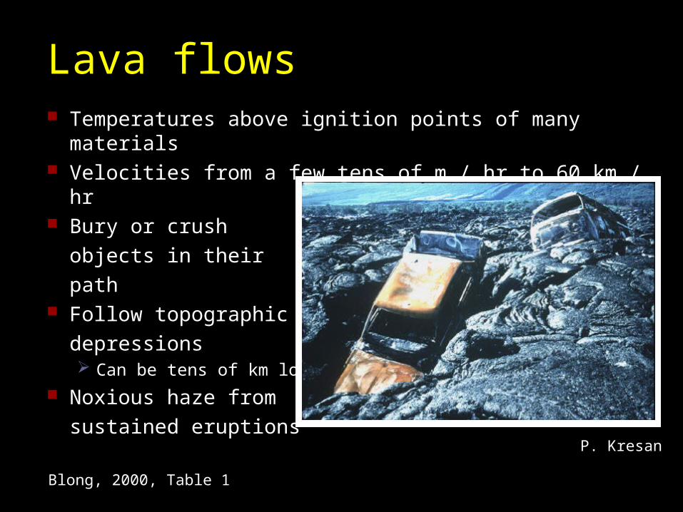
Lava flows Temperatures above ignition points of many materials Velocities from a few tens of m / hr to 60 km / hr Bury or crush
objects in their
path Follow topographic
depressions Can be tens of km long
Noxious haze from
sustained eruptions
Blong, 2000, Table 1
P. Kresan

Ballistic ejecta
>10 km radius of vent High impact energies Densities <3 t / m3
Fresh bombs above ignition temperatures of many materials
Blong, 2000, Table 1

Tephra falls Downwind transport velocity >10 to <100 km / hr Exponential decrease in thickness downwind Can extend >1000 km downwind Lapilli and ash (<64 mm diameter) are at thermal
equilibrium Can produce impenetrable darkness Compacts to half initial thickness in a few days Surface crusting encourages runoff Abrasive, conductive, and magnetic Airborne ash is a special hazard to aviation Ash accumulations on slopes of volcanoes can create
debris-flow hazards that may extend for several decades to centuries after eruptions
Blong, 2000, Table 1; Pareschi et al., 2000
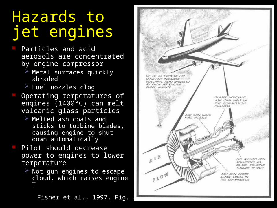
Hazards to jet engines Particles and acid aerosols are
concentrated by engine compressor Metal surfaces quickly
abraded Fuel nozzles clog
Operating temperatures of engines (1400°C) can melt volcanic glass particles Melted ash coats and sticks to
turbine blades, causing engine to shut down automatically
Pilot should decrease power to engines to lower temperature Not gun engines to escape
cloud, which raises engine T
Fisher et al., 1997, Fig. 8-4

Pyroclastic flows
Concentrated gas-solid dispersion Flow velocities up to 160 m / s Emplacement temperatures <100 to >900°C Small flows travel 5 - 10 km down topographic
lows Large flows travel 50 - 100 km Large flows climb topographic obstructions
At obstructions or bends in channels, lighter weight, intensely hot, upper part of density current can separate from lower part and move up hill
Blong, 2000, Table 1; Fisher, 1999, p. 98

Pyroclastic surges
Low concentration but high kinetic energy Radius of deposition 10 – 15 km Climb topographic obstructions Emplacement velocities >10’s of m / s
Blong, 2000, Table 1

Failure of caldera lakes
Calderas are natural reservoirs These reservoirs commonly sit at high elevation
Great hazards Some contain volumes that are comparable to
that in large natural reservoirsCrater Lake, OR 1.9 x 10¹⁰ m3
Atitlán, Guatemala 4.0 x 10¹⁰ m3
Katmai 3.3 x 10⁹ m3
Rims may be prone to failure
Waythomas et al., 1996

Lahars Generated with rainfalls <10 mm / hr Bulk fluid densities 2 – 2.4 t / m3; sediment
content 75-90 wt% Peak flow rates >10,000 m3 / s Velocities >10 m / s not uncommon Increase turbidity and chemical contamination in
water bodies Rapid aggradation, incision, or lateral migration Travel distances up to 10’s of km Hazard may continue for months or years after
eruption
Blong, 2000, Table 1

Mudflows
Aerial view of the Acaban River channel As it passes through
Angeles City near Clark Air Base
On 12 August
Mudflows caused collapse of main bridges Note makeshift bridges for
pedestrians at lower left
NOAA Mt Pinatubo-1991 Set, #16; photo by T.J. Casadevall, U. S. Geological
Survey

Jökulhlaups Can occur with little
or no warning Discharges may be
>100,000 m3 / s
Blong, 2000, Table 1
Smellie, 2000, Fig. 3
Outburst flood (toe of glacier at top)
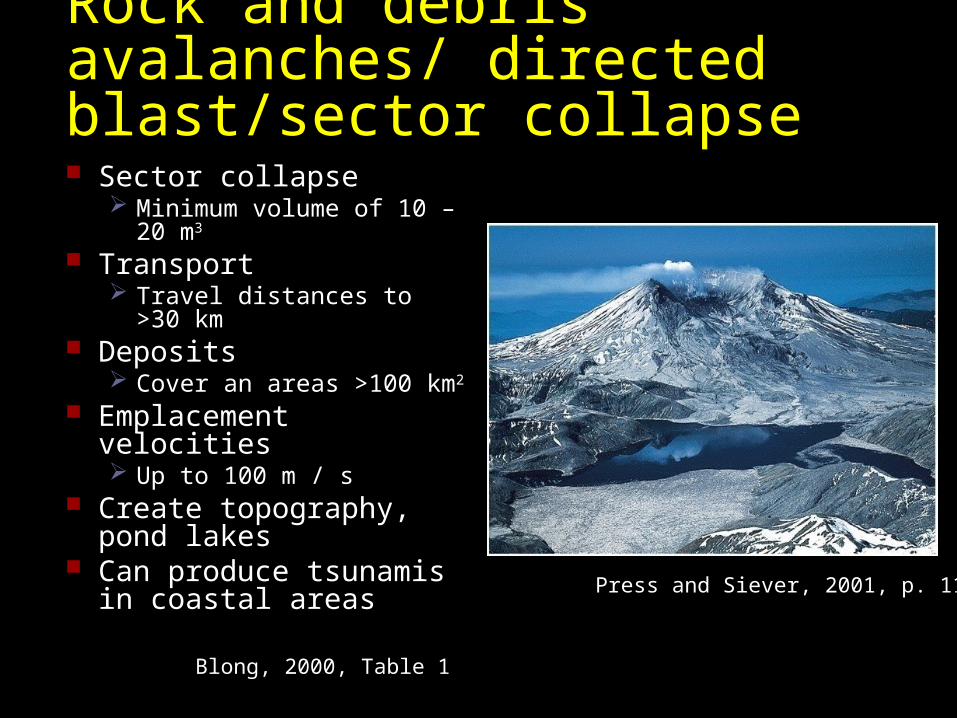
Rock and debris avalanches/ directed blast/sector collapse Sector collapse
Minimum volume of 10 – 20 m3
Transport Travel distances to >30 km
Deposits Cover an areas >100 km2
Emplacement velocities Up to 100 m / s
Create topography, pond lakes
Can produce tsunamis in coastal areas
Blong, 2000, Table 1
Press and Siever, 2001, p. 111

Earthquakes
Maximum Modified Mercalli intensity of 8 or less Damage limited to small areas Damage dependent on subgrade conditions Much stronger for caldera-related eruptions
Even small calderas or craters, as for PinatuboExacerbates other issues, like collapse of buildings
due to ash/water accumulations, as at Pinatubo
Modified from Blong, 2000, Table 1

Volcano-related earthquake damage Destruction of older brick structures in Pozzuoli, Bay of Naples, Italy Caused by earthquakes related to volcanic unrest at Campi Flegrei, 1982-
1984 Involved increased seismicity and 1.8 m of ground uplift but no eruption
Peterson and Tilling, 2000, Fig. 8

Ground deformation
Damage limited to 10 - 20 km radius Subsidence may affect 100’s of km2
From Table 1 of Blong, 2000

Bay of Naples, Italy Pozzuoli, Italy, at or near the center of the Campanian caldera that
erupted the Campanian ignimbrite 37 ka Area is site of repeated inflation and subsidence; some structures
historically have bobbed several meters above and below sea level
Fisher, 1999, Fig. 25

Ground deformation at Pozzuoli, Italy
Buttressed buildings in Pozzuoli, April 1984
Many buildings cracked
Buildings pushed out of line so that doors and windows would not open
Many inhabitants forced to evacuate to tent and trailer camps
Fisher, 1999, Fig. 26
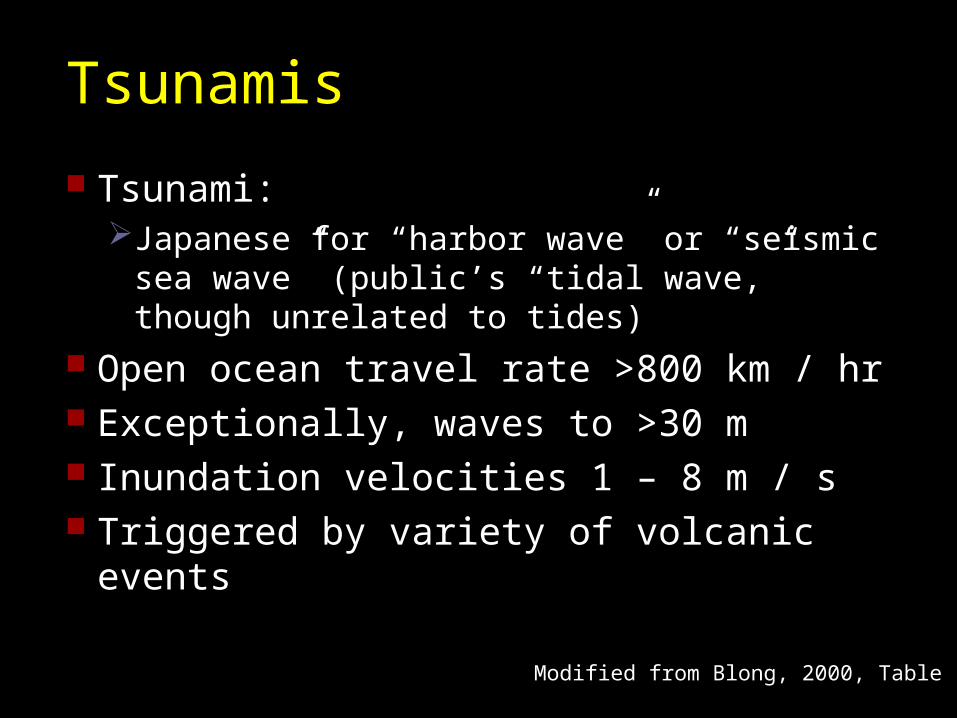
Tsunamis
Tsunami:Japanese for “harbor wave” or “seismic sea
wave” (public’s “tidal wave,” though unrelated to tides)
Open ocean travel rate >800 km / hr Exceptionally, waves to >30 m Inundation velocities 1 – 8 m / s Triggered by variety of volcanic events
Modified from Blong, 2000, Table 1

Augustine volcano, Cook Inlet, AK
West Island debris avalanche, 500 yr old, viewed from summit of Augustine volcano
Buried former coastline, traveled 5 km farther into Cook Inlet
Generate tsunami waves that run 5 – 30 m above sea level at distances of 80 – 100 km
Begét, 2000, Fig. 2
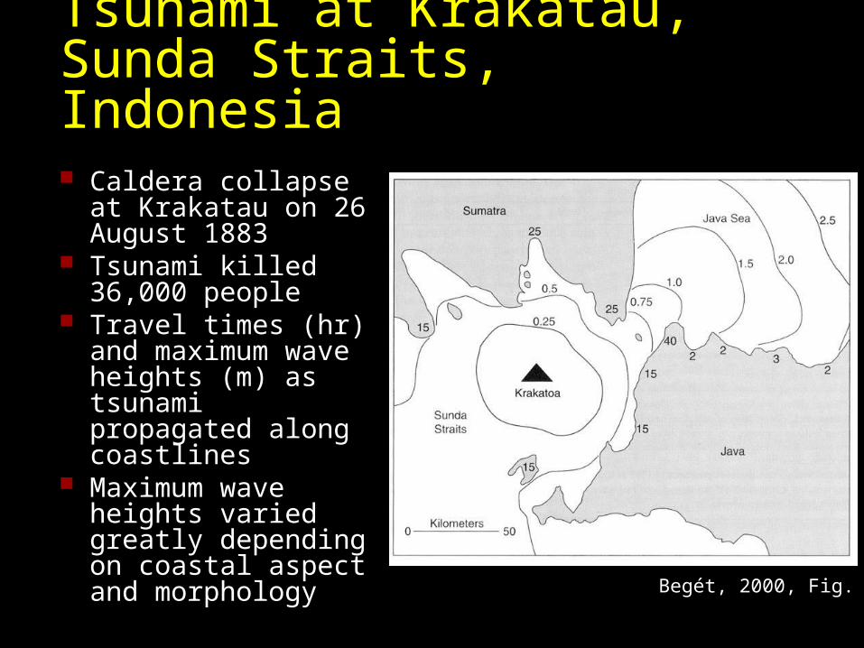
Tsunami at Krakatau, Sunda Straits, Indonesia Caldera collapse at
Krakatau on 26 August 1883
Tsunami killed 36,000 people
Travel times (hr) and maximum wave heights (m) as tsunami propagated along coastlines
Maximum wave heights varied greatly depending on coastal aspect and morphology Begét, 2000, Fig. 3
Volcanic triggers of tsunamis Santorini
Caldera collapse and pyroclastic flows into sea Wave height 10 - 50 m Travel distance 150 – 500 km
Mount St. Helens, 18 May 1980 Debris avalanche into Spirit Lake caused tsunami
Wave height 260 m Travel distance 4 km
Lake Nyos, CameroonExhalative emission of CO2
Wave height 25 - 75 m Travel distance 5 km

Air shocks
Up to 15-fold amplification of atmospheric pressure
Blong, 2000, Table 1

Lightning
Cloud-to-ground lightning from ash cloud
Strikes related to quantity of tephra
Electrostatic charge builds up from volcanic particles scraping against each other
Blong, 2000, Table 1
Fisher et al., 1997, Fig. 8-1; photo by José Viramonte
Lightning, Volcán Cerro Negro 1971, Nicaragua

Volcanic gases and aerosols
Water vapor a major component SO2 next most important
Corrosive or reactive: SO2, H2S, HF, HCl
CO2 in areas of low ground or poor drainage
pH of associated rainwater may be 4.0-4.5
Blong, 2000, Table 1

Gases and volcanic lakes
M. Barton
Cold springs degas below thermally stratified lakes, allowing accumulation of gas
Lake Monoun, 15 August 1984 Killed 39 people
Lake Nyos, 21 August 1986 Killed ~1700 people
Landslides may have triggered releases
Gas denser than air Hugs ground,
asphyxiating life in its path
Crater lakes along Cameroon volcanic line: alkalic volcanoes parallel to Benue rift

Summary--Petrologic synthesis; Volcanic hazards, I.
Petrologic synthesis Broad spectrum of magma compositions on Earth are related to a
multidimensional continuum of Earth processes Unlikely that compositions map uniquely against single geologic settings
Hazard, vulnerability, and risk Risk identification, analysis, reduction, transfer, and education Volcanic hazards
Lava flows Ballistic ejecta and tephra falls Pyroclastic flows and surges and rock/debris avalanches Catastrophic failure of caldera lakes Lahars, mudflows, and jökulhlaups Earthquakes, ground deformation, air shocks, tsunamis, and lightning Volcanic gases and aerosols

Lecture 24: Volcanic hazards, II: Eruption response and mitigation Cultural theories: People as risk takers
Individualist Egalitarian Hierarchist Fatalist Hermit
Volcanic crisis management Risk identification Risk analysis Risk reduction Risk transfer Risk education
The danger of living inside a paradigm Inquiry into breakthroughs Volcanic hazards: “What you don’t know you don’t know”

Cultural theories: Categories of people as risk takers Individualist
Optimistic view—building codes have been improved, so risk is decreased
Egalitarian Invokes precautionary principle, presses for urgent action Buildings are better but exposure is increasing (e.g., more
people), so better land-use planning needed Hierarchist
Everyone knows her/his place Things are about right as they are, but more research needed
and more regulation required Fatalist
Hopes for best, fears worst Whatever risk reduction is done, volcano will get you anyway
Hermit What volcano?
Blong, 2000, p. 1216

Questions What type of
risk taker are you?
What type of risk takers are the volcanologists who work on active volcanoes?
Possibility for a disconnect
Individualist Optimistic view—building codes
have been improved, so risk is decreased
Egalitarian Invokes precautionary principle,
presses for urgent action Buildings are better but exposure is
increasing (e.g., more people), so better land-use planning needed
Hierarchist Everyone knows her/his place Things are about right as they are,
but more research needed and more regulation required
Fatalist Hopes for best, fears worst Whatever risk reduction is done,
volcano will get you anyway Hermit
What volcano?

Stages of risk management
Risk identification Risk analysis Risk reduction Risk transfer Risk education
Blong, 2000

Risk analysis Relative risk indices for volcanoes in Papua New
Guineas for Volcanic Explosivity Index (VEI) = 4
Blong, 2000, Table II

Risk reduction
LaharsLateral dike made of
concrete designed to protect a town from lahars from Mayon volcano, Philippines
Blong, 2000, Fig. 2

Risk reduction Lahars
Settling basins made of steel and concrete on slopes of Usu volcano, Hokkaido, Japan
Retention ponds designed to impede the passage downstream of successively smaller boulders and trees
Principle Reduce energy of flow Trap the larger material Reduce the volume
Blong, 2000, Fig. 3

Risk reduction Ballistic ejecta
Reinforced concrete shelter designed to resist impact of ballistic ejecta, Sakurajima, Kyushu, Japan
Blong, 2000, Fig. 4

Risk education
Lack of knowledge of hazards was an issue even with USGS scientists and managersKraffts’ “disaster movies” helped
Education of the decision makers and the public during the monitoring phase was a key issue at the Nevado del Ruiz disaster “Flujos de lodo (mudflow) just didn’t mean a thing to
the people of Armero” --C. Newhall Confronting the issue for Pinatubo saved lives
Kraffts’ “disaster movies” helped again

Response and mitigation of lava flows
Fisher et al., 1997, Table 7-1
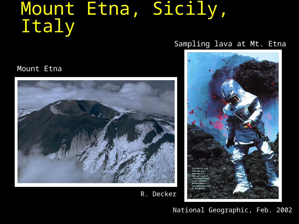
Mount Etna, Sicily, Italy
R. Decker
Mount Etna
National Geographic, Feb. 2002
Sampling lava at Mt. Etna

Mount Etna, Sicily, Italy Slow-moving mafic
lava flows Earthen barriers
slowed lava flows but generally have not been successful
Most effective control: diverting lava flows near the source, high on mountain, by breaching natural lava levees by excavation and blasting Began with eruption of
1991-1992 Saved village of
Zafferana Etnea Fisher et al., 1997, Fig. 7-3; adapted from Barberi et al., 1993

Mount Etna diversion
Peterson and Tilling, 2000, Fig. 10

Adjustments to risk
Modify the hazardNot likely for volcanoes
Modify vulnerability to hazardsLand use planningBuild diversions for lahars
Risk transfer--distribute loss to wider community InsuranceDisaster relief
Most common form of adjustment made: Do nothing
Blong, 2000, p. 1216

“What you don’t know you don’t know”
The danger of living inside a paradigmFalse sense of familiarityDecisions seriously affected by “What you
don’t know you don’t know”Corollary: The Law of Unintended
Consequences

Mount Unzen, 3 June 1991 French volcanologists Maurice
and Katia Krafft, American volcanologist Harry Glicken, and 40 Japanese journalists were killed during emplacement of a pyroclastic flow
What they knew Unzen produces small, though
remarkably numerous (>5000), pyroclastic flows from Plinian column collapse
Steep valleys on the volcano’s flanks channelize the pyroclastic flows
Adjacent ridges provide tempting perches to view small pyroclastic flows
Fisher et al., 1997, Fig. 5-4

Pyroclastic flow from dome collapse at Mount Unzen What they didn’t know
The flow could be larger in volume than earlier ones
Fisher et al., 1997, Fig. 5-5B

Pyroclastic flow from dome collapse at Mount Unzen What killed them
The flow was large enough to permit separation of glowing cloud from underlying glowing avalanche
The cloud climbed the ridge, engulfing their viewpoint
Fisher et al., 1997, Fig. 5-5A

The volcanologist and the public
The balancing actSounding the alarm to save livesThe cost of false alarms
False alarmsConsiderable monetary costs of evacuation,
work loss, etc.May cause people not to act the next time an
alarm is sounded

Nevado del Ruiz, Columbia Prediction of possible types of emplacement modes
during imminent eruption
Schmincke, 2004, Fig. 13.14

Nevado del Ruiz, Columbia Actual results of eruption, 13 Nov 1985
Very minor tephra fallout fan Deadly lahars in lower reaches of Río Guali Río Lagunillas
Schmincke, 2004, Fig. 13.14

Lessons from the Armero catastrophe, Nevado del Ruiz, Columbia On the whole, the government acted responsibly
But was not willing to bear the economic or political costs of early evacuation or a false alarm
Science accurately foresaw the hazards But was insufficiently precise to render reliable warning of the crucial
event at the last possible minute Crucial event occurred two days before the Armero emergency-
management plan was to be critically examined and improved Thus bureaucratic delays to progress of emergency management over
previous year also contributed to the catastrophic outcome
Fisher et al., 1997, Fig. 6-3
Voight, 1990
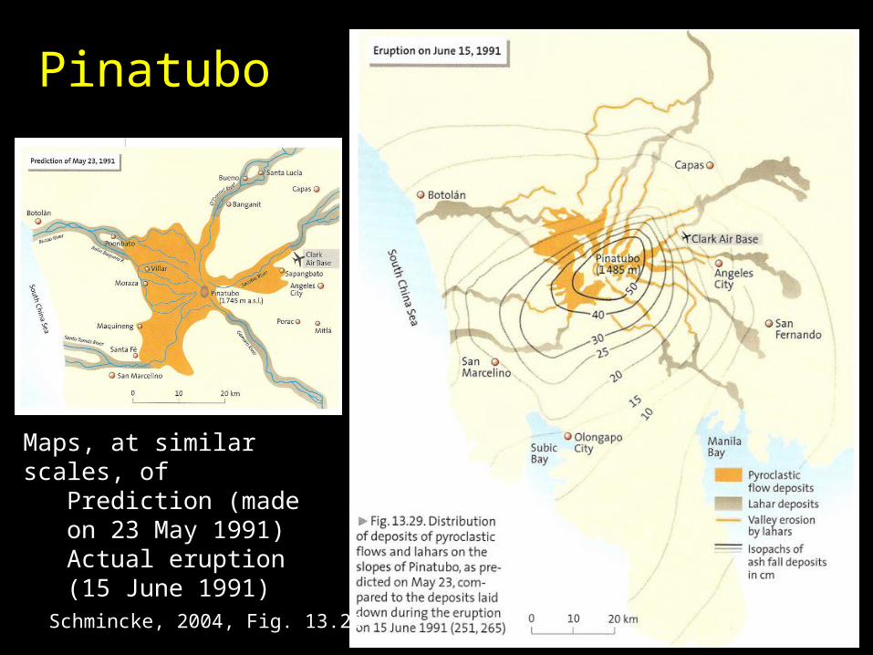
Pinatubo
Maps, at similar scales, ofPrediction (made on 23 May 1991)Actual eruption (15 June 1991)
Schmincke, 2004, Fig. 13.29

Special problem: Large eruptions
Managing risks from low probability – high impact eventsGreat difficulty in predictingNotoriously difficult for people to deal with rationally—
before and after the latest (rare) event
Analogies with fatalities at industrial accidents Compare the public and the government dealing
with the 9/11 terrorist attackBefore and after

A lesson from Mount St. Helens Great maps of distribution of eruptive
products of last 4500 yr, and good knowledge of its 40,000 yr historyExperts correctly predicted the ash
distribution, the mudflows, the floods, and the pyroclastic flows
But the experts couldn’t imagine a debris avalanche collapsing the mountain or the lateral blasts

Mount St. Helens lesson, cont’d The eruption involved a debris avalanche,
followed about a minute later by a directed blastNeither previously was a widely recognized volcanic
processThe avalanche and directed blasts of the 18 May
1980 eruption were far more destructive than the pyroclastic flows and lahars, which had been most feared
Scientists expected a clear warning of impending eruption, from leveling data, seismic monitoring, etc.None was recognized at the time
Only 2 of the 57 fatalities occurred within the “red zone” of hazard maps

Question
What about the next voluminous silicic, caldera-forming pyroclastic eruption?Something akin to an eruption that led to
deposition of the Bishop Tuff and collapse of the Long Valley caldera (or Yellowstone, etc.)
There is no historical precedent for an eruption as voluminous and explosive—nothing even close to it

Magnitude of the problem
Comparison of tephra volumes Note logarithmic
scale
Simkin and Siebert, 2000, Fig. 6

Mount St. Helens vs. Yellowstone
Cas and Wright, 1987, Fig. 5.8; after Sarna-Wojcicki et al., 1981
Fisher et al., 1997, Fig. 5-10
Measurable ash fallout from three eruptions from Yellowstone since 2.2
Ma covered more than half of US
For comparison, dispersal of ash from 18 May 1980 eruption of
Mount St. Helens

Question
What is it that we “don’t know we don’t know” about silicic, caldera-forming pyroclastic eruptions?

Question
What do you do—if anything—if you are concerned about what you don’t know you don’t know?

Breaking the cycle
“What you don’t know you don’t know” could be something regarding volcanic hazards
or It could be that you are looking for a
scientific breakthrough in another area (even something personal, rather than technical)

Consider engaging in an inquiry Act as if, or pretending that, you really don’t
know anything Purposefully approach the problem from an
entirely different point of viewLike an outsider would, like—or perhaps not like—a
technically trained person from another field would approach it (a botanist, an astrophysicist)
Work from first principles to see what might be possible
Be creativeBrainstorm about what might be possible, i.e., possible
scenariosEffectively engage others creatively—in groups

Possible benefits
Geologists have an easier time seeing what they’re looking for, rather than something they don’t expect
Create hypotheses, then test them against evidence that you never thought to look for before
Intentional breakthrough discovery vs. serendipitous discovery

Summary Cultural theories: People as risk takers
Individualists, egalitarians, hierarchists, fatalists, and hermits
Respond differently; require different strategies to engage Volcanic crisis management
Risk identification (volcanologists) Risk analysis (engineers and scientists) Risk reduction (government: building codes, land use
planning, physical diversions) Risk transfer (policy makers, insurers) Risk education (public servants and others)Most common form of risk adjustment made: Nothing
The danger of living inside a paradigm Volcanic hazards: “What you don’t know you don’t know” Inquiries may lead to breakthroughs
Next time: Volcanism and mineral deposits, I.