geoscience data transfers standards: earthresourceml and geosciml, tools to deliver mineral...
TRANSCRIPT

1
Geoscience Data Transfers Standards: EarthResourceML and
GeoSciML, tools to deliver mineral resources data in EU and
globally. The EU-MKDP example
Jouni, Vuollo1, Taina Eloranta1, Daniel Cassard 2, Robert Tomas3
and Chris Schubert3
1GTK, Rovaniemi, Finland, 2BRGM), Orléans, France 3 and JRC, Ispra, Italy
J Vuollo - 26th November 2014 – MINCE - First international conference on minerals in Circular Economy, Espoo, Finland

2
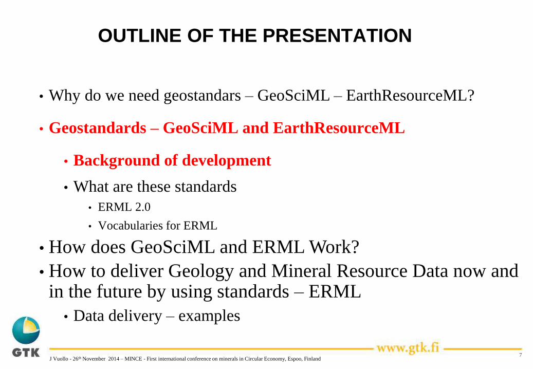
OUTLINE OF THE PRESENTATION
• Why do we need geostandars – GeoSciML – EarthResourceML?
• Geostandards – GeoSciML and EarthResourceML
• Background of development
• What are these standards
• ERML 2.0
• Vocabularies for ERML
• How does GeoSciML and ERML Work?
• How to deliver Geology and Mineral Resource Data now and in the future by using standards – ERML
• Data delivery - examples
J Vuollo - 26th November 2014 – MINCE - First international conference on minerals in Circular Economy, Espoo, Finland

3
OUTLINE OF THE PRESENTATION
• Why do we need geostandars – GeoSciML – EarthResourceML?
• Geostandards – GeoSciML and EarthResourceML
• Background of development
• What are these standards
• ERML 2.0
• Vocabularies for ERML
• How does GeoSciML and ERML Work?
• How to deliver Geology and Mineral Resource Data now and in the future by using standards – ERML and GeoSciML
• Data delivery – examples
J Vuollo - 26th November 2014 – MINCE - First international conference on minerals in Circular Economy, Espoo, Finland

Why do we need geostandars – GeoSciML –
EarthResourceML?
Why we need geostandards – classifications –vocabularies now
Until now, classifications have tended to be country / state dependent,
Data delivery systems/ways are changing - > interoperability needs are here
Globalization – exploration companies are doing work all over the globe!
Spatial data infra in EU/INSPIRE implementation
Geology and Mineral Resource themes are based on these global
geostandards
4J Vuollo - 26th November 2014 – MINCE - First international conference on minerals in Circular Economy, Espoo, Finland
Modified from B Simons – 2013- Canberra 2013

Why EarthResourceML?
5J Vuollo - 26th November 2014 – MINCE - First international conference on minerals in Circular Economy, Espoo, Finland
Why we need geostandards –classifications – vocabularies now
• How to find gold deposits from Europe – national databases
According to agreed EarthResourceML global commodity code list - 290 terms
• Minerals4EU will use this INSPIRE/global code list
Kulta-Au
золото
zloto
gold
gull
or
oro
Gold
guld
ouro

Western Australia Northern Territory
Why GeoSciML?
• The problem of incompatible data
Unit identifier
Age
Description
J Vuollo - 26th November 2014 – MINCE - First international conference on minerals in Circular Economy, Espoo, Finland
Modified from O Raymond/GA - 2013-CGI meeting
7
OUTLINE OF THE PRESENTATION
• Why do we need geostandars – GeoSciML – EarthResourceML?
• Geostandards – GeoSciML and EarthResourceML
• Background of development
• What are these standards
• ERML 2.0
• Vocabularies for ERML
• How does GeoSciML and ERML Work?
• How to deliver Geology and Mineral Resource Data now and in the future by using standards – ERML
• Data delivery – examples
J Vuollo - 26th November 2014 – MINCE - First international conference on minerals in Circular Economy, Espoo, Finland

A Brief History - GeoSciML
• 2003, Edinburgh - Starting point to develop Geostandard for geological society
– first international meeting held to begin harmonisation of geological data models developed in North America, Europe, and Australia
– several precursor projects were considered, including
• the North American Data Model (NADM)
• the Australian Exploration and Mining Markup Language (XMML)
• the Multi-Lingual Thesaurus of Geology
• First step was to develop GeoSciML and data model for deliver geological data• 2004, Ottawa & Florence
– CGI launched and its Interoperability Working Group (IWG) was formed
• 2004, Perth - first official meeting of the IWG GeoSciML Task Group
• 2005, Ottawa - GeoSciML version 1
• 2006, Orleans, Liege & Brussels
• 2007, Tucson & Melbourne - GeoSciML version 2
• 2008, Orleans, Uppsala & Oslo
• 2009, Quebec
• 2010, Rome
• 2011, Edinburgh
• 2012, Wellington - GeoSciML version 3
– Work under Open Geospatial Consortium (OGC)
• 2013, Redlands and St. Petersburg
• 2014, Tucson
J Vuollo - 26th November 2014 – MINCE - First international conference on minerals in Circular Economy, Espoo, Finland

9
A Brief History - ERML
• Extension of GeoSciML v3.0
• Developed by Australian geological survey organisations
– Started 2006
– MineralResourceML v. 1.0 released 3/2007 and v. 1.1. 6/2009
– Australian Design Task Group
• Governance now with the CGI-IUGS (9/2010)
– Earth ResourceML Interoperability Working Group established –2010 September
– EarthResourceML v 2.0 released June 2012 – see http://www.earthresourceml.org
• Potential uptake by international community
– European projects/SDI’s accepted as a standard– INSPIRE – EURARE – EGDIScope – Minerals4EU
J Vuollo - 26th November 2014 – MINCE - First international conference on minerals in Circular Economy, Espoo, Finland

A Brief History – GeoSciML and ERML
• British Geological Survey, UK
• CSIRO, Australia
• Geological Survey of Canada
• US Geological Survey
• Arizona Geological Survey, USA
• Geological Survey of Japan
• Geoscience Australia
• Geological Survey of Victoria, Australia
• BRGM, France
• Geological Survey of Sweden
• Geological Survey of Italy (ISPRA)
• Geological Survey of Finland
• GNS Science, New Zealand
• Landcare Research, New Zealand
• BGR, Germany
• plus many observers
• and in 2013, the Open Geospatial Consortium
Contributing
Organisations
J Vuollo - 26th November 2014 – MINCE - First international conference on minerals in Circular Economy, Espoo, Finland

11
OUTLINE OF THE PRESENTATION
• Why do we need geostandars – GeoSciML – EarthResourceML?
• Geostandards – GeoSciML and EarthResourceML
• Background of development
• What are these standards
• ERML 2.0
• Vocabularies for ERML
• How does GeoSciML and ERML Work?
• How to deliver Geology and Mineral Resource Data now and in the future by using standards – ERML and GeoSciML
• Data delivery – examples
J Vuollo - 26th November 2014 – MINCE - First international conference on minerals in Circular Economy, Espoo, Finland

12J Vuollo - 26th November 2014 – MINCE - First international conference on minerals in Circular Economy, Espoo, Finland
• A language for exchange of geoscience information
• Developed by IUGS Commission for Geoscience Information (CGI-IUGS)
• Based on North American Data Model (NADM)
• Covers data shown on geological maps (geology, boreholes)
• INSPIRE standard, moving to OGC standard (version 4)
GeoSciML

13J Vuollo - 26th November 2014 – MINCE - First international conference on minerals in Circular Economy, Espoo, Finland
• Developed by GGIC now governed by CGI-IUGS
• Extension of GeoSciML
• Covering mineral occurrences, mines, mining activities, commodities, mining waste
• INSPIRE standard
ERML
14
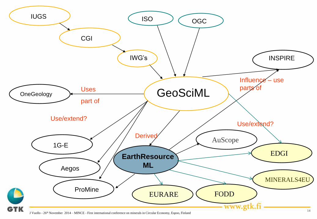
OneGeologyUses
part of
EarthResource
ML
Derived
GeoSciML
IUGS
CGI
IWG’s
ISO OGC
INSPIRE
Influence – use
parts of
MINERALS4EU
EURARE FODD
EDGI
Use/extend?
AuScope1G-E
Use/extend?
Aegos
ProMine
J Vuollo - 26th November 2014 – MINCE - First international conference on minerals in Circular Economy, Espoo, Finland

15
INSPIRE
• What is INSPIRE
• INSPIRE is "an EU initiative to establish an infrastructure for
spatial information in Europe
• 34 different spatial themes
• INSPIRE has adopted both geostandards as a base on Geology
and Mineral Resource data specifications
• Geology – GeoSciML
• Mineral Resources – EarthResourceML and GeoSciML
(part)
•Overview
• http://inspire.jrc.ec.europa.eu/index.cfm/pageid/2 -
•Data models
• http://inspire.jrc.ec.europa.eu/index.cfm/pageid/2/list/datamodels
J Vuollo - 26th November 2014 – MINCE - First international conference on minerals in Circular Economy, Espoo, Finland

16
OUTLINE OF THE PRESENTATION
• Why do we need geostandars – GeoSciML – EarthResourceML?
• Geostandards – GeoSciML and EarthResourceML
• Background of development
• What are these standards
• ERML 2.0
• Vocabularies for ERML
• How does GeoSciML and ERML Work?
• How to deliver Geology and Mineral Resource Data now and in the future by using standards – ERML and GeoSciML
• Data delivery – examples
J Vuollo - 26th November 2014 – MINCE - First international conference on minerals in Circular Economy, Espoo, Finland

17
EarthResourceML
• Earth Resource: natural material of potential economic value
• Mining Feature: working on the Earth Resource
Earth Resource:
• Mineral Occurrence
• Commodity and Commodity Measure
• Ore Measure
• Mineral deposit model
• Exploration Activity (INSPIRE)
• Earth Resource Material
• Supergene processes (ex. alteration)
• Mineral system
Mining Feature:
• Mine
• Mining Activity
• Mined material
• Products
• Mining waste (INSPIRE)
J Vuollo - 26th November 2014 – MINCE - First international conference on minerals in Circular Economy, Espoo, Finland

EarthResourceML v 2.0 - EarthResource
18
class MineralOccurrence
«FeatureType»
EarthResource
«estimatedProperty, voidable»
+ dimension: EarthResourceDimension
+ expression: Category [1..*]
+ form: Category [1..*]
+ linearOrientation: CGI_LinearOrientation [1..*]
+ planarOrientation: CGI_PlanarOrientation [1..*]
+ shape: Category [1..*]
«voidable»
+ sourceReference: CI_Citation [1..*]
«DataType»
SupergeneProcesses
«voidable»
+ depth: QuantityRange
+ material: EarthMaterial [1..*]
+ type: Category
«FeatureType»
MineralOccurrence
«voidable»
+ endusePotential: EndusePotentialValue [1..*]
«estimatedProperty»
+ type: MineralOccurrenceTypeValue
«FeatureType»
MineralSystem
+ associationType: Category
«Type»
MineralDepositModel
«estimatedProperty»
+ mineralDepositGroup: MineralDepositGroupValue [1..*]
«estimatedProperty, voidable»
+ mineralDepositType: MineralDepositTypeValue [1..*]
«DataType»
EarthResourceMaterial
+ earthResourceMaterialRole: EarthResourceMaterialRoleValue
+ material: EarthMaterial
«voidable»
+ proportion: QuantityRange
MiningFeature
«FeatureType»
Mine::MiningActiv ity
«estimatedProperty»
+ activityDuration: TM_Period
+ activityType: MiningActivityTypeValue
+ processingType: ProcessingActivityTypeValue
«estimatedProperty, voidable»
+ oreProcessed: Quantity
«FeatureType»
Mine::Product
+ product: ProductValue
+ sourceReference: CI_Citation [1..*]
«estimatedProperty, voidable»
+ grade: Quantity
+ production: Quantity
+ recovery: Quantity
«FeatureType»
Commodity
+ commodity: CommodityCodeValue
«estimatedProperty, voidable»
+ commodityImportance: ImportanceValue
+ commodityRank: Integer
«DataType»
EarthResourceDimension
«estimatedProperty, voidable»
+ area: QuantityRange [1..*]
+ depth: QuantityRange [1..*]
+ length: QuantityRange [1..*]
+ width: QuantityRange [1..*]
«DataType»
OreMeasure
+ classificationMethodUsed: ClassificationMethodUsedValue
+ date: TM_GeometricPrimitive
+ sourceReference: CI_Citation [1..*]
«estimatedProperty, voidable»
+ dimension: EarthResourceDimension
«estimatedProperty»
+ ore: QuantityRange
«voidable»
+ proposedExtractionMethod: Category
«DataType»
Endowment
«voidable»
+ includesReserves: Boolean
+ includesResources: Boolean
«DataType»
Reserv e
+ category: ReserveCategoryValue
«DataType»
Resource
+ category: ResourceCategoryValue
«voidable»
+ includesReserves: Boolean
«DataType»
CommodityMeasure
«estimatedProperty, voidable»
+ commodityAmount: QuantityRange
+ cutOffGrade: QuantityRange
+ grade: QuantityRange
«CodeList»
MineralOccurrenceTypeValue
«CodeList»
EarthResourceMaterialRoleValue «CodeList»
ResourceCategoryValue
«CodeList»
ImportanceValue
«CodeList»
CommodityCodeValue
«FeatureType»
ExplorationActiv ity
+ activityDuration: TM_Period
+ activityType: ExplorationActivityTypeValue
+ explorationResult: ExplorationResultValue [1..*]
«CodeList»
ExplorationActiv ityTypeValue«CodeList»
ExplorationResultValue
«CodeList»
ClassificationMethodUsedValue«CodeList»
EndusePotentialValue«CodeList»
MineralDepositGroupValue
«CodeList»
MineralDepositTypeValue«CodeList»
Reserv eCategoryValue
+composition
«voidable»
1..*
+oreAmount
«voidable»
1..*
+resultantResource
«voidable»1..*
+geneticDescription
«voidable»
1
+child
«voidable»
1..*
+parent
«voidable»
1
+supergeneModification
«voidable»
1..*
+producedMaterial
1..*
+measureDetails
1..*
+commodityOfInterest
1..*
+explorationHistory
«voidable»
1..*
+classification
«voidable»
1
+sourceCommodity
1
+resourceExtraction
«voidable»
0..*
+deposit1
+source
1
+commodityDescription
1..*
J Vuollo - 26th November 2014 – MINCE - First international conference on minerals in Circular Economy, Espoo, Finland

19
class Mine
«FeatureType»
Mine
+ mineName: MineName [1..*]
+ status: MineStatusValue
«voidable»
+ endDate: TM_Instant [0..1]
+ sourceReference: CI_Citation [0..*]
+ startDate: TM_Instant
«DataType»
MineName
+ isPreferred: Boolean
+ mineName: CharacterString
«CodeList»
MineStatusValue
«DataType»
MinedMaterial
+ material: EarthMaterial
+ rawMaterialRole: RawMaterialRoleValue
«voidable»
+ proportion: QuantityRange
«FeatureType»
MiningActiv ity
«estimatedProperty»
+ activityDuration: TM_Period
+ activityType: MiningActivityTypeValue
+ processingType: ProcessingActivityTypeValue
«estimatedProperty, voidable»
+ oreProcessed: Quantity
«CodeList»
MiningActiv ityTypeValue
«FeatureTyp...
MiningFeature
«FeatureType»
MiningFeatureOccurrence
+ observationMethod: Category [1..*]
«voidable, estimatedProperty»
+ positionalAccuracy: Quantity
«voidable»
+ resolutionScale: MD_RepresentativeFraction
«FeatureType»
Product
+ product: ProductValue
+ sourceReference: CI_Citation [1..*]
«estimatedProperty, voidable»
+ grade: Quantity
+ production: Quantity
+ recovery: Quantity
«CodeList»
RawMaterialRoleValue«CodeList»
ProcessingActiv ityTypeValue
«FeatureType»
MiningWaste
+ wasteType: MiningWasteTypeValue
«voidable, estimatedProperty»
+ environmentalImpact: EnvironmentalImpactValue [1..*]
+ material: EarthMaterial [1..*]
+ wasteMeasure: MiningWasteMeasure
«voidable»
+ storageType: WasteStorageTypeValue [1..*]
«CodeList»
WasteStorageTypeValue
«CodeList»
MiningWasteTypeValue
«DataType»
MiningWasteMeasure
«voidable»
+ density: Quantity
+ grade: Quantity
+ volume: Quantity
«CodeList»
ProductValue
«CodeList»
Env ironmentalImpactValue
+associatedMine
«voidable»
1
+producedWaste
«voidable»
1..*
+rawMaterial
«voidable»
1..*
+producedMaterial
1..*
+relatedActivity
1..*
+specification
1
+occurrence
0..*
RelatedMines
+relatedMine
«voidable»
1..*
EarthResourceML v 2.0 – Mining Activity
J Vuollo - 26th November 2014 – MINCE - First international conference on minerals in Circular Economy, Espoo, Finland

20
OUTLINE OF THE PRESENTATION
• Why do we need geostandars – GeoSciML – EarthResourceML?
• Geostandards – GeoSciML and EarthResourceML
• Background of development
• What are these standards
• ERML 2.0
• Vocabularies for ERML
• How does GeoSciML and ERML Work?
• How to deliver Geology and Mineral Resource Data now and in the future by using standards – ERML and GeoSciML
• Data delivery – examples
J Vuollo - 26th November 2014 – MINCE - First international conference on minerals in Circular Economy, Espoo, Finland
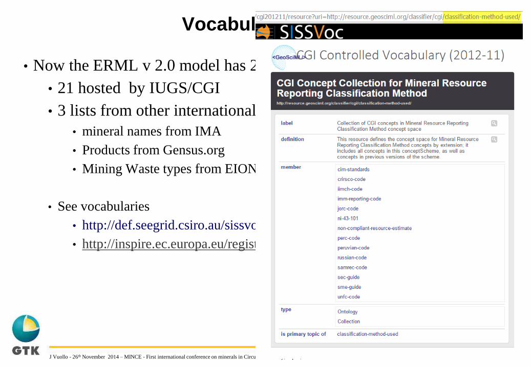
Vocabularies for ERML
21
• Now the ERML v 2.0 model has 24 code lists
• 21 hosted by IUGS/CGI
• 3 lists from other international organizations
• mineral names from IMA
• Products from Gensus.org
• Mining Waste types from EIONET
• See vocabularies
• http://def.seegrid.csiro.au/sissvoc/cgi201211/collection
• http://inspire.ec.europa.eu/registry/
J Vuollo - 26th November 2014 – MINCE - First international conference on minerals in Circular Economy, Espoo, Finland

22
EarthResourceML v 2.0 – Code lists
J Vuollo - 26th November 2014 – MINCE - First international conference on minerals in Circular Economy, Espoo, Finland

23
OUTLINE OF THE PRESENTATION
• Why do we need geostandars – GeoSciML – EarthResourceML?
• Geostandards – GeoSciML and EarthResourceML
• Background of development
• What are these standards
• ERML 2.0
• Vocabularies for ERML
• How does GeoSciML and ERML Work?
• How to deliver Mineral Resource Data now and in the future by using standards – ERML and GeoSciML
• Data delivery – examples
J Vuollo - 26th November 2014 – MINCE - First international conference on minerals in Circular Economy, Espoo, Finland

How Does GeoSciML and ERML Work?
GA
GTK
BRGM
USGS
GSCCanada
USA
France
Finland
Source databases
(eg, Oracle, ArcGIS,
PostGIS, MySQL)
Australia
Web mapping apps,
portals,
GIS applications,
modelling applications,
analytical tools
WWWINTEROPERABILITY
“My stuff works with your stuff”
Modified from O Raymond/GA - 2013-CGI meeting
J Vuollo - 26th November 2014 – MINCE - First international conference on minerals in Circular Economy, Espoo, Finland

How Does GeoSciML and ERML Work?
GA
GTK
BRGM
USGS
GSCCanada
USA
France
Finland
Source databases
(eg, Oracle, ArcGIS,
PostGIS, MySQL)
Australia
WMS
WFS
WMS
WFS
WMS
WFS
WMS
WFS
WMS
WFS
GSC mapping
USGS mapping
BRGM mapping
GA mapping
GTK mapping
Transformation
from database to
GeoSciML/ERML
schema
Web
services
(eg, Geoserver, Snowflake, Deegree, Mapserver)
Web mapping apps,
portals,
GIS applications,
modelling applications,
analytical tools
WWWGeoSciML-ERML
GeoSciML-Portrayal
Modified from O Raymond/GA - 2013-CGI meeting
J Vuollo - 26th November 2014 – MINCE - First international conference on minerals in Circular Economy, Espoo, Finland

How Does GeoSciML and ERML Work?
WMS
WFS
WMS
WFS
WMS
WFS
WMS
WFS
WMS
WFS
GA
GTK
BRGM
USGS
GSCGSC mapping
USGS mapping
BRGM mapping
GA mapping
GTK mapping
Canada
USA
BRGM
Finland
Australia
WWWGeoSciML-ERML
GeoSciML-Portrayal
Many data formats One standard format
Web mapping apps,
portals,
GIS applications,
modelling applications,
analytical tools
Modified from O Raymond/GA - 2013-CGI meeting
J Vuollo - 26th November 2014 – MINCE - First international conference on minerals in Circular Economy, Espoo, Finland

27
OUTLINE OF THE PRESENTATION
• Why do we need geostandars – GeoSciML – EarthResourceML?
• Geostandards – GeoSciML and EarthResourceML
• Background of development
• What are these standards
• ERML 2.0
• Vocabularies for ERML
• How does GeoSciML and ERML Work?
• How to deliver Geology and Mineral Resource Data now and in the future by using standards – ERML and GeoSciML
• Data delivery – examples
J Vuollo - 26th November 2014 – MINCE - First international conference on minerals in Circular Economy, Espoo, Finland
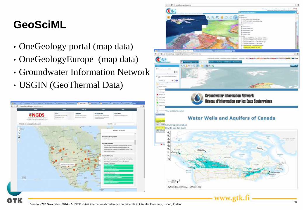
GeoSciML
• OneGeology portal (map data)
• OneGeologyEurope (map data)
• Groundwater Information Network
• USGIN (GeoThermal Data)
28J Vuollo - 26th November 2014 – MINCE - First international conference on minerals in Circular Economy, Espoo, Finland

EarthResourceML
• AuScope portal (5 national surveys)
• ProMine (one database)
• EuroGeoSource (5 national surveys )
29J Vuollo - 26th November 2014 – MINCE - First international conference on minerals in Circular Economy, Espoo, Finland

30
OUTLINE OF THE PRESENTATION
• Why do we need geostandars – GeoSciML – EarthResourceML?
• Geostandards – GeoSciML and EarthResourceML
• Background of development
• What are these standards
• ERML 2.0
• Vocabularies for ERML
• How does GeoSciML and ERML Work?
• How to deliver Geology and Mineral Resource Data now and in the future by using standards – ERML and GeoSciML
• Data delivery – examples
J Vuollo - 26th November 2014 – MINCE - First international conference on minerals in Circular Economy, Espoo, Finland

How to deliver Mineral Resource data – EU
Minerals4EU – EU-MKDP
31J Vuollo - 26th November 2014 – MINCE - First international conference on minerals in Circular Economy, Espoo, Finland

32J Vuollo - 26th November 2014 – MINCE - First international conference on minerals in Circular Economy, Espoo, Finland

Geostandards - Internet Resources
GeoSciML and ERML home• http://www.geosciml.org
• http://www.earthresourceml.org
IUGS – CGI – general info
• http://www.cgi-iugs.org/tech_collaboration/geosciml.html
• http://www.cgi-iugs.org/tech_collaboration/earthResourceML.html
Schemas
• http://schemas.geosciml.org
• http://schemas.earthresourceml.org
Vocabularies
• http://resource.geosciml.org
• http://def.seegrid.csiro.au/sissvoc/cgi201211/collection
J Vuollo - 26th November 2014 – MINCE - First international conference on minerals in Circular Economy, Espoo, Finland

Making Mineral Resource Data for the Earth
Accessible MineralResource Portal
VISION 2020f
Mineral resource data -
AuScope - ProMine –
Minerals4EU (EU-
MKDP - INSPIRE - >
Global data
Minerals4EU
34J Vuollo - 26th November 2014 – MINCE - First international conference on minerals in Circular Economy, Espoo, Finland