geoscience information in africa (giraf) · cgi, the geological survey of namibia, bgr, and...
TRANSCRIPT

www.giraf-network.org
Dar es Salaam, CAG 25
15th August, 2014
Geoscience Information in Africa
(GIRAF):
Kristine AschGIRAF coordinator

www.giraf-network.org
Agenda: 5 „W“s
• What is the GIRAF network
• Why the GIRAF network
• Who is the GIRAF network
• Workshop and achievements
• Where does the GIRAF go from here?
Addis Ababa, CAG 24
January 14, 2013

www.giraf-network.org
What is the GIRAF - Geoscience Information in Africa Network
Network on Geoscience InfoRmation in AFrica for
geological survey organisations, universities and
research institutes and private companies.
• initiated by the Commission on Geoscience Information
(CGI) of the IUGS
• founded with support of the German Federal Ministry for
Economic Cooperation and Development, the IUGS-
CGI, the Geological Survey of Namibia, BGR, and
Southern Mapping
• coordinated by the CGI and UNESCO-Africa
•

www.giraf-network.org
GIRAF Mission
Support that
knowledge-based geoscience information
Contributes
to improve the environmental & economic prosperity
of the people in Africa.

www.giraf-network.org
Why a GIRAF network
• Many isolated geoscience information projects within Africa
• Only rarely existing: African Geoscience information standards
• Vast amounts of inaccessible data
and research results
• Education and training:
Find and retain skilled people
• Fragmentation of institutional responsibilties
• Government and administration often unaware
of the importance of geoinformation
• Strenghten connections and linking
with neighbour countries
• More cooperation with the mining sector and private
companies

www.giraf-network.org
GIRAF Aims
• Build a pan-African geoscience information knowledge
network of geological surveys, universities, research institutes
and companies.
• Stimulate and support cross-border
geoscience information projects
and initiatives in Africa.
• Make Africa a more active part of the international geoscience
information community.
• Encourage the creation of African cross-border geoscience
information standards and
• Encourage the contribution to international and global
standards

www.giraf-network.org
GIRAF members

www.giraf-network.org
• Algeria
• Angola
• Botswana
• Burkina Faso
• Cameroon
• Central African Republic
• Congo
• DR Congo
• Egypt
• Ethiopia
• Gambia
• Gabun
• Ghana
• Ivory Coast
• Kenya
• Lesotho
• Liberia
• Madagascar
• Malawi
Associated Organisations:
• Geological Society of Africa
(GSAf)
• SEAMIC
• African Association of Women
Geologists (AAWG)
• Young Earth Scientists (YES)
• Commission of the Geological
Map of the World (CGMW)
• OneGeology
• AEGOS
• Mali
• Morocco
• Mozambique
• Namibia
• Nigeria
• Ruanda
• Senegal
• South Africa
• Southern Sudan
• Sudan
• Tanzania
• Togo
• Uganda
• Zambia
• Zimbabwe
37 African GIRAF member countries

www.giraf-network.org
Who –14 GIRAF Ambassadors

www.giraf-network.org
Workshops and GIRAF achievementsOrganise and realize:
2007 Preparatory workshop at CAG 22, Mocambique
2009 Kick-off Workshop of GIRAF, GSN, Namibia
(incl. short courses on GeoScience ML and Freeware)
2011 GIRAF workshop with AEGOS & OneGeology at CAG23, Jo‘burg
2011 2nd GIRAF Workshop, SEAMIC, Dar es Salaam
(incl. short courses on GeoScienceML and Freeware)
2012 Int. Geological Congress, Brisbane: GIRAF course at Sustainable
Mining in Africa Workshop, GIRAFpresentation, Boothm Flyers:
-> >72 new members, 8 new African countries
2012 Geoscience Information session at CAG24, Ethiopia
2013 3rd GIRAF Workshop, September, Ghana
2014 – Geoscience information Workshop at CAG 25

www.giraf-network.org
Achievements:Newsletterweb site
14 embassies
• The

www.giraf-network.org
Where does the GIRAF walk fromhere?
• 2015 - 4th GIRAF Workshop in Mocambique
• 2016 – GIRAF session at Int.Geol.Congress in
Capetown
• 2016 - 5th GIRAF session at CAG 26 in ….?
• 2017 - 5th GIRAF workshop in ….?

www.giraf-network.org
GIRAF!!!
www.giraf-network.org
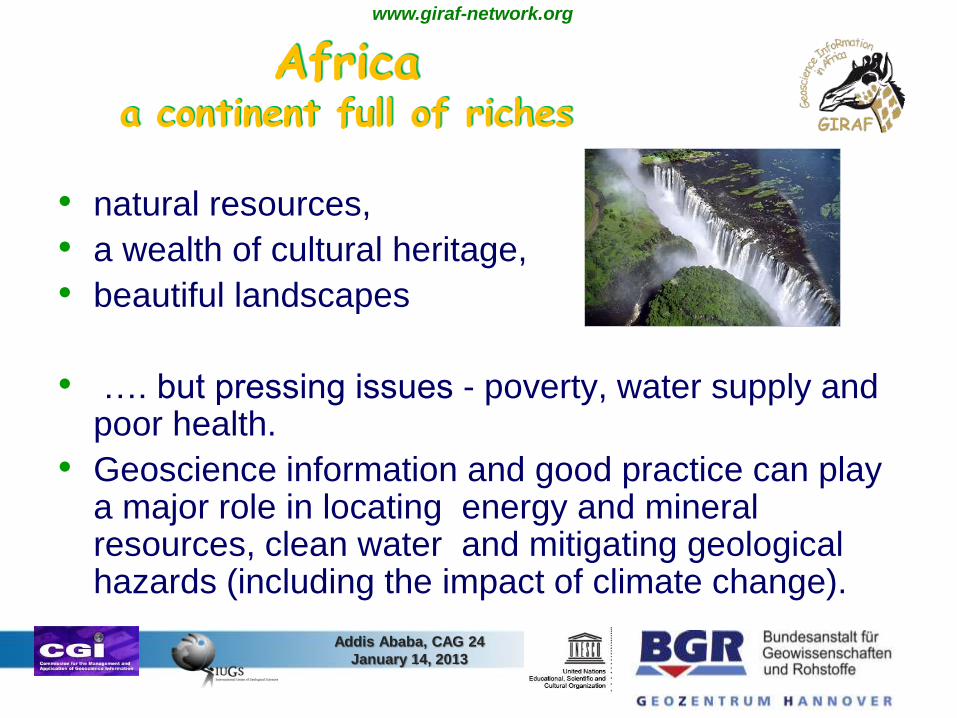
Africaa continent full of riches
• natural resources,
• a wealth of cultural heritage,
• beautiful landscapes
• …. but pressing issues - poverty, water supply and poor health.
• Geoscience information and good practice can play a major role in locating energy and mineral resources, clean water and mitigating geological hazards (including the impact of climate change).
Addis Ababa, CAG 24
January 14, 2013

www.giraf-network.org
GIRAF!!!

www.giraf-network.org
The GIRAF Agreement
The participants agreed on;
- Establish network within Africa to connect geological survey
institutions
- Support nations with lack of capacity and capability
- Set up of management group to ensure that GIRAF is sustained
- Set up of Website with national contact details, news, links
- Organise biannual workshops of GIRAF
- Nominate African delegates to IUGS-CGI, OneGeology
- Get a Geoscience Information Session into the IGC 2012
- Start and distribute a Newsletter
- Organise funding and sponsorship to support GIRAF-work
- Pursue training and scholarships at existing universities.
-
-

www.giraf-network.org
Who - GIRAF Steering Committee• John Agyei Duodu Director Geological Survey of Ghana (chair)
• Mesfin W. Gebremichael SEAMIC, Tanzania (Vice-Chair)
• Aberra Mogessie President Geological Society of Africa (GSAf)
• S. Felix Toteu UNESCO Nairobi
• Ezzoura Erami, president African Association of Women Geologists
• Masresha Gebresillasie Director Geological Survey of Ethiopia
• Gabi Schneider Director Geological Survey of Namibia
• Cecilia Mukosi Council of Geosciences, S.A., YES Network
• Kristine Asch BGR, coordinator GIRAF,
bridge to interrnational community

www.giraf-network.org

www.giraf-network.org
Geocience Information, SustainableMining and Mapping
• Information is knowledge
• Geoscience information is essential knowledge
about the ground beneath our feet
• Crossboundary geoscience data, knowledge
and information lead to new insights, innovation
and discovery
.. and in thus – in the long run to more wealth
and health in Africa !

www.giraf-network.org
GIRAF!!!

www.giraf-network.org
Why GIRAF ?
• The giraffe is a beautiful African animal,
• full of confidence and strength
• (and amazingly fast …) .
• long neck: a good overview over much more
than its close neighbourhood
• The pattern – a metaphor for all African
nations
• so a perfect symbolic animal for our Network
across the (almost) whole continent of Africa!

www.giraf-network.org
A selection of necessary activitiesidentified by the GIRAF members
• Raise awareness of politicial decision makers on Geoscience information issues
• Influence „law-making“ in the sector of for geoscience information
• Training for members of geological survey staff:
– Digital field mapping methods
– Digital reconnaissance exploration (remote sensing, airborne geophysics, regional geochemistry …)
– OpenGIS
– Data management and administration
• Support initiation of public private partnerships in the mining sector
• Identify and approach funding sources for the GIRAF member‘s activities
• Communicate via mail, the GIRAF web site and a newsletter.
Digital field mapping methods
Digital reconnaissance exploration (remote sensing, airborne geophysics, regional geochemistry …)
OpenGIS
Data management and administration

www.giraf-network.org
First known geological map: created in Africa
• the “Turin Papyrus”: a map of a
Nubian gold mine in the north
today’s Egypt
• created during the reign of King
Ramses IV (1151–1145 b.C.)
• depicts gold ore deposits, rock
types (sandstone, boulders)
• includes several elements of
topography and geomorphology,
(some kind of road, a mine
workers' settlement , several
valleys, Harrel & Brown (1992)
• “the earliest map known“ (Murray, 1946 and Walther, 1994)

www.giraf-network.org
• “Africa is the world’s top producer of numerous
mineral commodities and has the world’s
greatest resources of many more, but most of
Africa still lacks systematic geological
mapping which could bring to light a much
greater resource base”,
(Africa Mining Vision prepared by the African
Union in 2009)

www.giraf-network.org
Geological databases: attractivefor mineral exploration investment
Research survey by the Fraser Institute (2008):
• 372 mining companies representing 14.8% of the global
exploration investment rated the attractiveness of 68
countries (incl: 10 countries from sub-Saharan Africa)
based on 15 factors.
• “geological database” incl. quality and scale of maps, ease
of access to information by investors) ione of the 15 factors;
Survey encompasses also e.g. legal and taxation
framework, political stability, the cost and qualifications of
labour, security, good governance or the existence and
quality of infrastructure

www.giraf-network.org
Cost-benefit ratio of geological mapping
• Recent studies of the cost-benefit ratio of geological
mapping (in Spain and USA) documented ratios of
19 (Spain) and 32 (USA).
• Ratio 1 : 19 means->
for e.g. 1 Euro the society invests in geological
mapping, the return will be 19 Euros
(from: Economic and Social Value of the MAGNA Plan – geological
maps of Spain at a scale of 1:50 000 published by Instituto
Geológico y Minero España, 2005).

www.giraf-network.org
Geoscientific knowledge and skills of
African geological surveys
– a feasibility study
• Feasibility Study for a long-term project
• May be financed by DG DEVCO (Development and
Cooperation – EuropeAid) for a period of 12 months,
start in 2013
• Main aims:
• Strengthening of OAGS
• GAP and SWOT analysis Geoscientific Mapping
• GAP and SWOT Mineral Resources
• Digital Methods and tools
27

www.giraf-network.org
The GIRAF network
consists of geoscience experts all over Africa.
The GIRAF members know well about the
problematic (and non-problematic) issues of
geoscience information in Africa and possess the
knowledge and motivation to contribute to its
solution.

www.giraf-network.org
GIRAF 2013
Invitation
to the 3rd GIRAF Workshop - GIRAF2013 –
in Accra, Ghana,
3-5 days in September 2013 (date to be confirmed here with the local hosts)
During the centennial celebrations of the Geological Survey of
Ghana
Organisation: IUGS-CGI and UNESCO-Nairobi
Hosted by the Geological Survey of Ghana
Will include subjects of geoscience information
in mapping, mineral resources, sustainable mining,
geohazards, and other relevant themes proposed by GIRAF
steering committee and individual members.
Presentations, discussion, break-out groups and short courses.

www.giraf-network.org
Welcome to the next
GIRAF workshopin Ghana,
September 2013 !

www.giraf-network.org
Thank you very muchfor your attention

www.giraf-network.org
Project frame
• The feasibility study may be financed by DG
DEVCO (Development and Cooperation –
EuropeAid) for a period of 12 months, start in 2013;
• The long-term pan-African project is pl be realised in
a period of 10 to 20 years;
• Concrete figures for the period and budget by the
EU are not yet known.
32

www.giraf-network.org
Situation in general
• African countries are increasingly willing to upgrade
their geoscience knowledge infrastructures, inc. the
fundamental ability to make new geological maps
(e.g. Ghana, new survey project 1 : 100.000)
• The geological surveys in Europe took part in the
geological mapping in Africa in the past and present
(e.g. by technical development projects or World
Bank) or private sector contracts.
• -> A joint EU-Africa initiative in the field of geological
mapping would greatly benefit both continents,

In the beginning just
some lines
in the sand .....
to describe e.g.
a flint or salt occurence ...
Unkown geoscientist

www.giraf-network.org
Summary
• GIRAF- experts
• Earliest Map ever created in Africa
• Still substantial parts of Africa not sufficiently
mapped

www.giraf-network.org
Mapping: crucial precondition for mining
• Most of the 54 African states have a “geological
survey” and a “mineral management structure”,
which plays an important role in the development
and the management of the minerals sector.
• A crucial element in this process is to improve
the geological knowledge base as well as
training of the government institutions involved
especially in the mining sector.

www.giraf-network.org
Situation in general
• Availability and access to geological information in Africa
is currently limited
• a large percentage of the continent is yet to be
geologically mapped in a systematic manner and at
an appropriate scale (< 100 000)
• Geological maps are a basic tool for countries
- to take stock of their resources
- to attract investors
- to grant exploration permits,
- to provide practical training to young geologists.

www.giraf-network.org
The reasons for these gaps have been discussed at various occasionsThe Geoscience Information in Africa Network (GIRAF) stated in its
second workshop in Dar es Salaam (SEAMIC) in 2011::
• substantial need of training, including mapping and GIS, within the
African geological community.
• lack of financial resources and the need to seek financial support to
initiate appropriate training programmes.
Additional fundamental issues stated in the 2009 GIRAF Workshop in
Namibia (Geological Survey of Namibia, Windhoek) :
• Vast amounts of inaccessible data and research results
• Find and retain skilled people.
• Government and administration often unaware of the importance of
geoinformation,
• Lack of technical infrastructure, internet access and equipment.

www.giraf-network.org
Project Objectives
• Strengthening the cooperation between OAGS and
EGS;
• Promotion of the role of OAGS in Africa and
augmentation of its recognition by society;
• Contribution to the assessment of the potential of
mineral resources in Africa
• Strengthening of the capacities and the role of
national geological surveys in Africa, especially in
the field of geological mapping and map editing;
• ...
39
www.giraf-network.org
Feasibility StudyFurther Project Objectives
• Improvement of data management as well as the
use of geoinformation;
• Evaluation of synergies with current corresponding
projects in Africa;
• Consolidation of inter-institutional and international
networks for capacity building within African
geological surveys;
40
www.giraf-network.org
Proposed Major Project Activities and Milestones of the feasibility study
• Identification of the existing and required information and knowledge domains;
• Strength, weaknesses, opportunities and threats (SWOT) analysis of partner institutions;
• Development of a road map and work breakdown structure .
41

www.giraf-network.org
WP 3 - Geoscientific Mapping
42

www.giraf-network.org
WP 3 - Geoscientific Mapping
Compilation of a map catalogue / index maps of
available maps on:
Geology
Mineral occurrences, e.g. raw materials, energetic
minerals
Geochemistry
Geophysics
Remote Sensing data
43

www.giraf-network.org
WP 3 - Geoscientific mapping
• to get an overview about geospatial metadata of published and unpublished digital and analogue maps for geology, mineral resources, groundwater, geophysics, geochemistry and imageries on international, national, regional and local scales;
• to identify areas which need more detailed field mapping in those themes;
• to identify the actual and potential users needs and
Identification of areas where detailed geological mapping is required
to propose recommendations to better the situation.
Gap analysis:
44

www.giraf-network.org
WP 3 - Geoscientific mapping
Deliverables:
D 3.1 – Concept for a web-based metadata catalogues for
geodata and maps in Africa, to be compiled in
coordination with AEGOS;
D 3.2 – Gap analysis: Report containing an overview on existing
available geoscience maps and geodata in Africa as well
as a description of the present mapping activities in
African countries by national Geological Surveys;
D 3.3 - Concept Note on strategies to strengthen the capacities
of African geological surveys in the field of geological
mapping and the provision of geodata (maps and web
services).
45

www.giraf-network.org
Proposed Major Project Activities and Milestones for the Phase 2 (2014 -2018)
46
The project should cover a wide range of tasks divided
into
the several working packages such as:
• Coordination
• Actions needed to strengthen the OAGS (e.g.
development of a new/improved website for OAGS)
• GAP analysis of geoscientific mapping
• Mineral resources assessment gap analysis
- Primary and secondary sources
- Artisanal and small-scale mining (ASM)
- Mining and the environment (including post-
mining)

www.giraf-network.org
Proposed Major Project Activities and Milestones for the Phase 2 (2014 -2018)
47
• Geohazards mapping and monitoring
• Geoheritage inventory and its economic significance
• Methods / tools (human resources and capacity building and training for OAGS members and their partners through innovative case studies)
• Development of OAGS Geoscience information infrastructure and management
• Development of OAGS technical infrastructure, laboratories, equipment, facilities
• Dissemination of information about the project and building and running database of the obtained results

www.giraf-network.org
Previous Meetings
• Launching meeting in Warsaw, September 9,
2012 (BGR, BGS, BRGM, CZ-GS, EC, EGS, GEUS, GTK, IGME
Spain, IGME Greece, Geo-ZS, LGT, PGI_NRI, SGU, SGUDS)
• First presentation and discussion of the proposal of
the feasibility study during the OAGS-EGS meeting
on the occasion of the World Bank’s Pre- African
Development Forum (‘Pre-ADF’) Event on
Geological Mapping and Mineral Inventory in
Africa in Niamey, Niger, December 11 to 15, 2012.
48

www.giraf-network.org
Next steps 1
Review of the proposal
• EGS: 15. 01. 2013
• preliminary version of the proposal to EU to
start the process of commissioning
• OAGS: 28. 02. 2013
• Binding and mandatory for EGS and OAGS
• Submission to EU for financing
49Addis Ababa, CAG 24
January 14, 2013

www.giraf-network.org
Next steps 2
• Each WP will get an African Co-Coordinator,
nominated by OAGS
• First draft of the results of the scoping are
expected by July/August 2013
• Final-Workshop of the Scoping Study with results
and planning strategy for phase 2 in 4th quarter
2013 (October/November 2013) in combination
with the annual meeting of OAGS and the
Centennial of GSD in Accra
50

www.giraf-network.org
www.giraf-network.org
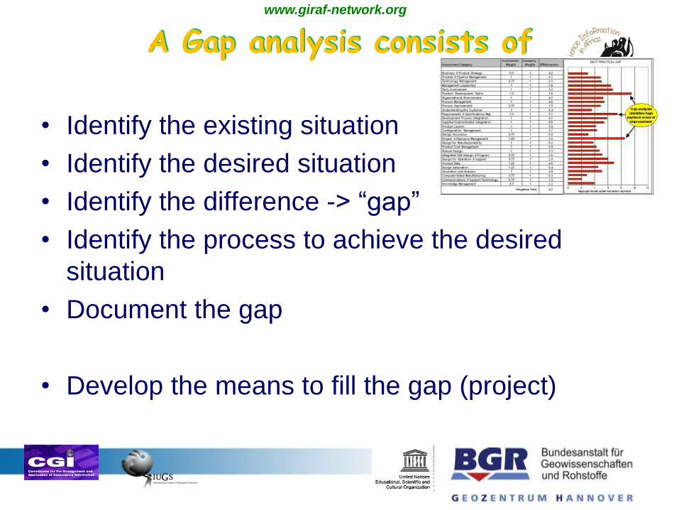
A Gap analysis consists of
• Identify the existing situation
• Identify the desired situation
• Identify the difference -> “gap”
• Identify the process to achieve the desired
situation
• Document the gap
• Develop the means to fill the gap (project)

www.giraf-network.org
Gap analysis – methods
• Workshops
- for prepartion
- for performance of activitity, check of method
- for evaluation
• Personal interrogation
• Questionnaire analogue
• Questionnaire digital
• Evaluation and documentation.
• Result: Conclusions and recommendations

www.giraf-network.org
Cost estimation• Cost estimation:
• Depending on needed results
person/months, infrastructure, travel costs, workshops
• Examples:
OneG-E (interrogates: 20 countries): WP 2 ca 200 000
Euro/2 years/20 person months
• AEGOS (interrogated: ca. 50 organisations), 9 WPs, 2 M
Euro/3 years

www.giraf-network.org
Objectives of the gap analysis
• Field mapping (Geology, groundwater, hazards,
engineering geology, geophysical, geochemical
…) - > derived maps: mineral and energy
resources, gw resources
• Sampling and testing (petrography,
geochemistry, age determination, geophysics,
water )
• Interpretation methods
• Publishing methods

www.giraf-network.org
Gap analysis for Mapping - projectplanning
• Build the project team to perform the gap analysis
• Work package definitions
• Draft time frame /road map
• Identify whom to address:
- 54 Geological survey organisations.
- Mining Companies (are mapping acc. Their requirements)
- Universities?
- Experts, subcontractors?
- Politicians?
- International players (OAGS, AU, GSAf, UNESCO, SADC, ..),
- Centers of excellence (SEAMIC, … )
• (Project collate addresses and contacts)
• (Decide on method)
www.giraf-network.org
Examples of questions
• Mapping (Geology, groundwater, mineral and energy resources,
hazards, geophysical…) :
- coverage
- Scale
- Themes
- date of publishing
technique of mapping: remote sensing, field work, geochemistry , …
- technique of map production: Analogue/digital
• Staff/skills:
Field geologists, surveyor, IT technicians, lab technicians,
• Infrastructure:
Laboratories: geochemistry, petrography, geophysical equipment,
cars
digitizing tools
• Regular sufficient budget

www.giraf-network.org
Gap Analysis: Possible Workpackages
• WP 1 Project management
• WP 2 Staff and skills in Africa
• WP 3 Availability of maps (theme, scale, medium, at
what costs, distribution, …)
• WP 5 Mapping Methods and Actual mapping activities
• WP 6 Annual planning of African organisations (budget,
political acknowledgement, dstaff management, mandate
for mapping
• WP 7 African Institutions Infrastructure (labs, technical
equipment etc)
• WP 8 Concept and strategy

www.giraf-network.org
Project resources: an estimate
Duration: 1,5 years
Partner: important: African partners
8 Workpackages: core teams: 5 – 10 persons
8 Deliverables: At least 1 / workpackage
3 general Workshops (+ ca 3 per WP): 30
Technical meetings
Staff time
Project coordinator: 18 + 4
WP lead: 12 p/m
Contributing partner: ca. 4 p/m

www.giraf-network.org

www.giraf-network.org
• Work Package Description 1 G-E WP 2
• Start date:0
• End date:18
• Work package title:User cases and best practice in meeting stakeholder needs
•
• Objectives
• Identify the current and future, specific and generic needs for geological information products and
services by users/stakeholders. Assess how current provision across Europe meets these needs.
Identify what the best practice is in meeting these needs and also gaps where needs are not being
met (through lack of data, services or barriers to use). Demonstrate and spread the awareness of
best practice service provision across the suppliers and potential users in Europe and report on
how service provision can be improved.
•
• Description of work
• Define, prioritise and summarise the needs of the broad spectrum of users of geological data.
Assemble a stakeholder panel representing European, national and local government; insurance,
banking and property; environmental protection; sustainable groundwater and soils management;
landscape and natural heritage; civil engineering; energy and mineral exploration and extraction;
civil protection; natural disasters management; education and research. Organise two workshops
at which external stakeholders (users) and providers will discuss a) data and service needs and b)
proposed solutions to these. Prioritise the data and service types based on stakeholder demand.
Audit of best practice in geological data and service delivery across Europe in meeting that
demand. Review and selection (involving Stakeholders) of best practice in existing access
(including, viewing and downloading and reporting systems) to high resolution (1:10000 –1:50000
scale) geological and applied geological data across the EU (ie including systems covering natural
hazards and resources in addition to geological data). Document examples of best practice
across a range of users and countries and conduct and report on a gap analysis (demand-
provision).

www.giraf-network.org
GIRAF ….
the Geoscience InfoRmation in AFrica network
for African geological survey organisations,
research institutes, universities and private
companies.
• Initiated by the global IUGS Commission on the Management &
Application of Geoscience Information (CGI)
• Coordinated by CGI and UNESCO
• Started with financial support of the German Federal Ministry
for Economic Cooperation and Development, via BGR and the
Geological Survey of Namibia
• Now supported with modest financial and in-kind contributions
from the CGI/IUGS, UNESCO and the individual members‘
institutions