geospatial information for landslide hazard assessment in lombok, indonesia yukni arifianti (cvghm,...
TRANSCRIPT

Geospatial Information for Landslide Hazard Assessment
in Lombok, Indonesia
Yukni Arifianti (CVGHM, GAI)Akbar Cita (CGS, GAI)
Heryadi Rachmat (GM, GAI)Matthias Dorn (BGR)
Malaysia Geospatial ForumMelaka, 6 - 7 March 2012
I. IntroductionII. Landslides in IndonesiaIII. Landslides in LombokIV. Geospatial dataV. Process analysisVI. Discussion
Outline
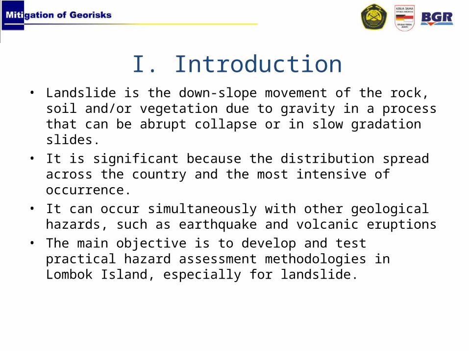
• Landslide is the down-slope movement of the rock, soil and/or vegetation due to gravity in a process that can be abrupt collapse or in slow gradation slides.
• It is significant because the distribution spread across the country and the most intensive of occurrence.
• It can occur simultaneously with other geological hazards, such as earthquake and volcanic eruptions
• The main objective is to develop and test practical hazard assessment methodologies in Lombok Island, especially for landslide.
I. Introduction

LANDSLIDE
GEOLOGICAL CONDITION
RAINFALL
MORPHOLOGY/SLOPE
VEGETATION
EARTHQUAKE
CONTROLLING FACTORS

• The Geological Agency of Indonesia (GAI), Ministry of Energy and Mineral Resources (MEMR) and BGR (German Federal Institute for Geoscience and Natural Resources) set up a joint project to support the implementation of the results of georisk assessment methodologies in national, provincial and local georisk mitigation strategies.
• Partners and cooperation:1. GAI2. Ministry of Home Affairs (MoHA)3. Indonesian National Board for Disaster Management (BNPB)4. Provincial and Local Government5. GIZ with “Decentralization and Good Local Governance”
GEORISK PROJECT

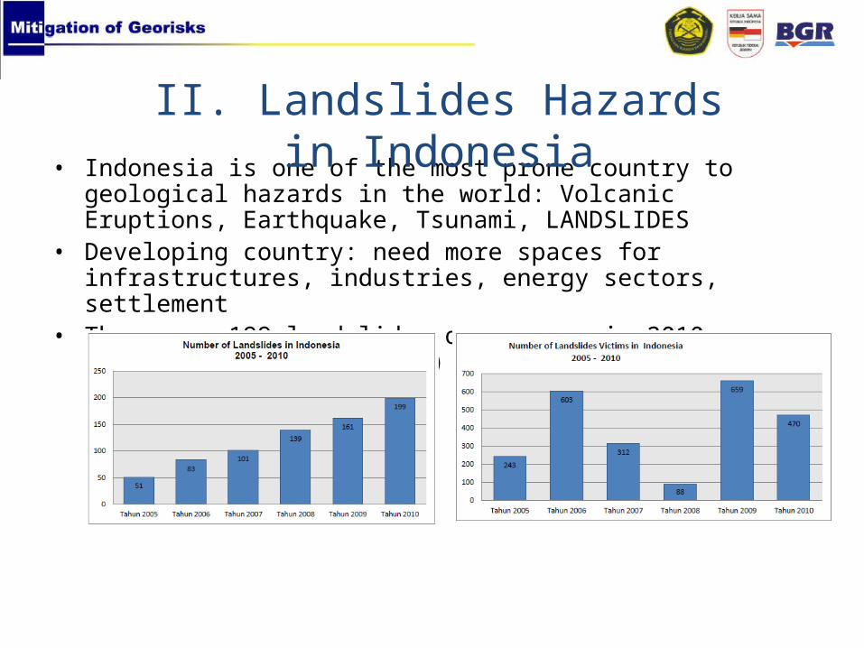
• Indonesia is one of the most prone country to geological hazards in the world: Volcanic Eruptions, Earthquake, Tsunami, LANDSLIDES
• Developing country: need more spaces for infrastructures, industries, energy sectors, settlement
• There are 199 landslides occurrence in 2010, killed 470 people (CVGHM)
II. Landslides Hazards in Indonesia

Geological condition of Indonesia
(CVGHM, GAI)

LANDSLIDE EVENTS IN INDONESIA (1990 – 2009)
(CVGHM, GAI)

Spatial Planning in Landslides Prone Area
(CEG, GAI)

III. Landslides Hazards in Lombok
• Lombok is an island in West Nusa Tenggara Province of Indonesia with an area of 5.435 km2 with 3.098.480 inhabitants • Located at 115° 45’ – 116° 45’ E and 8° 00’ – 9° 00’ S• It is as an internationally alternative eco-tourism destination after Bali.

• Field checking was carried out in 2011 and found 4 new landslides from 13 possible landslides that were detected by ASTER. • The investigation classified 147 landslides are of natural origin and 47 landslides are man-made triggered. • The type of landslide are mainly rotational and translational.

Translational @ Krujuk
Unconsolidated pumice
Mining area Man-made landslide

(Heryadi Rachmat, 2011)

Landslide Susceptibility Assessment (Technical Workflow)

Landslide point •Landslide points from GAI and local government.• Additional landslide inventory using ASTER images and Google Earth.
Landslide factors• Lithology from GAI• Updated lineament map using the 1995 Landsat TM image.• Land cover data derived from 2004 and 2009 Landsat ETM+ images.• Topographic features: slope angle, slope aspect, flow direction, elevation derived from ASTER GDEM data.• Vegetation Indices; Normalized Difference Vegetation Index (NDVI) derived from ASTER and MODIS images.
Data sources
IV. Geospatial data

Landslide’s Geo-factors
Landslidepoints

V. Process analysis

• Image processing was done with the ENVI 4.8 software. Other data layers listed above were processed and added to a Geo-database with Arc GIS 10 software.
• A statistical approach using probability and weighting methodology was applied to extract standardized weights for the different layers
• The spatial data analysis and integration for landslide assessment can be divided into three steps (Teerarungsigul, et.al, 2011):1. To overlay the landslide distribution with factors2. To perform the probability analysis and weighting.3. To produce the landslide susceptibility map

1. To overlay the landslide distribution with factors

2. To perform the probability analysis and weighting
• Reliability probability (RP) was calculated by the percentage area of factors corresponding to landslides
• Accountability probability (AP) was calculated by the total landslides population accounted for each factor.
RP =Σ % number of landslide
Σ % area in the same classes
AP =Σ % number of landslides in classes having a pobability ratio ≥ 1
Σ % landslide point over the entire study area

Factor RP W(RP) AP W(AP) Weight
Slope 3.86 22 76.65% 14 18
Lineament 1.81 14 79.70% 19 17
NDVI 1.18 3 91.96% 22 13
Elevation 2.61 19 54.27% 6 13
Lithology 1.23 6 79.40% 17 12
Flow direction 1.39 11 63.82% 8 10
Aspect 1.24 8 69.54% 11 10
Land-use 2.15 17 44.72% 3 10
Probability analysis and weighting

3. To produce the landslide susceptibility map

• The analysis resulted in slope, lineament and NDVI as the most influence factors. The slope factor ranges from 45 to 50 while dense forest is the land-use class that has a high probability of landslides. Landslides in Lombok mostly occurred on the mountainous and hilly areas.
• Lithology and lineament was examined to find out how geological factor affect the landslides. The analysis demonstrates that lineament is more affected. It creates weak zone that vulnerable to landslides. This shape built by volcanic and fault activities. The presence of pumice as unconsolidated rock proceeds as a weak layer for landslides movement.
• Geospatial Technology of Geographic Information System (GIS) and Remote Sensing can ease landslide hazard assessment. It provides a high efficiency and optimizes time resources. However a field work needs to be done to validate the analysis.
VI. Discussion
