geospatial information portal phm - esri · geospatial information portal phm september 6th, 2018...
TRANSCRIPT

Geospatial Geospatial Information Portal Information Portal
PHMPHM
September 6th, 2018
Novandy Ritung
PERTAMINA HULU MAHAKAMPERTAMINA HULU MAHAKAM

BackgroundBackground Pertamina Hulu Mahakam is one subsidiary of PERTAMINA GROUP, Indonesia State Company. Field Operation area stretches over a quite vast area of 90km by 65km in Mahakam Delta Estuary and Offshore area.
The Fields consist of large number of production receiving & transporting facilities Assets ie. 41 Gathering
and Testing Satellite Platforms, 829 remote wellhead platforms, 30 offshore Manifold Wellhead Platforms,
over 2,000 kms pipelines with 700 kms sea lines, approx. 2,450 wells, and are controlled by 6 Processing Units and Sites. .

• High operational activities take places ie. more than 10 well intervention barges in daily basis, more than
5 dredging and crane barges for site maintenance
/modifications/well connection, 4 swamp rigs to drill
more than 60 wells per year, 2 jack-up rigs to drill up
to 10 wells per year, movement of 300 fleet (rig, barges, vessel, any boats) with various potential operational risks are spreading in the area. There are around 50 work permits open on each Site with
almost 2,000 personnel working in daily basis. * the figure shown is based on average operational activities during period 2015 to 2017
Background…Background…
Besides, societal issue is taking part. Starting 1990, the shrimp farming activities has rapidly developed in Mahakam Delta. As Mahakam Delta configures 46 small deltaic islands with forestry area, it will not easy for Company to perform monitoring for environment and landscape changing in the Mahakam Delta.

There are many applications running on daily basis to monitor and to control all these assets and operational activities. Most of them are dealing with geographic coordinates or maps. Each application owned, managed and used by different entities in Company with their own purpose to handle a very large amount of data in various databases.
Background…Background…
Scattered Data & ApplicationsScattered Data & Applications

How to figure-out and manage intensity and distribution of the works to ensure safe and reliable operation in such a wide area?
To ensure all operations is carried out safely. How to control the risks and be vigilant with any potential risks associated with operational activities?
Scattered information and lack of “single-window” application give results inefficiency and huge effort for any entities to compile all those information comprehensively in order to support a decision making of planning, operation, up-to emergency response strategy.
ChallengesChallenges

• Implementation of technology for Data Integration : data collecting, data management, data processing & production and data sharing
• ArcGIS Enterprise chosen as innovative technical solution to integrate and synergize any applications and data on GIS platform
at the enterprise level
• It is a solution that provide an “one single window” as one stop service tool to give all kind of information required instantly and in a comprehensive view to support interdivision in company such as Health Safety Environment, Field Operation, Geosciences, Engineering & Construction, Drilling & Well Service, Logistic & Marine Transport, Societal, Pipeline Inspection, Land Management, Security, etc.
SolutionSolution

Geospatial Geospatial Information Information
PortalPortal
7
Logistics & Transport
•Marine route •Vessel dataset •Real-time Tracking
Engineering, Construction & Project
•Base Map •Imagery Map •Survey Data •Facilities Data •Engineering Data
Health, Safety & Environment
•Environment •Medical •Health Facilities
Sustainable Development & Societal
•Societal Data •Claims •Land Parcel •Forestry •Demographic
Geosciences
•Well head •Well target •Trajectories •Reservoir
Field Operation
•Work Permit •Down Grade Situation •Plant Information •Inspection Data
Well Construction & Intervention • Well Intervention Barge
General Services
•Mosquito spread mapping
Office & Field
•View •Analyst •Query •Searching •Printing
•Security Risk •Security Event •Security Profile
Security
Integrated Data CollaborationIntegrated Data Collaboration

• Enterprise Platform
• Integrated Contents
• Integrated Workflow
Data Collecting & ProcessingData Collecting & Processing
Geospatial Data ManagementGeospatial Data Management
Mobile Map
Tiled Services
Map Services
Analysis & Modeling Services
Geometry
Image Services
Geospatial Web ManagementGeospatial Web Management
Geospatial InformationGeospatial Information
Mobile Desktop
Web
Geospatial Geospatial Information Information
PortalPortal
Integrated SystemIntegrated System

All assets and activities can be visualized and monitored to support decision making by considering and compiling all data/information required comprehensively. Information of assets (wells, pipeline, valve, etc), real-time position of fleet (rig, work construction barge, well service barge, dredging barge, marine fleet, tug boat, small marine boats, etc) including type of job/operation being done, environmental (bio-diversity, water quality, real-time weather condition, etc), social-economical data such as demography (population, public facilities, social structure, etc) can be plotted, linked and interfaced to topography map and simultaneously overlaid with result of any analysis on a single window and can be extreemly useful to provide information for:
New Well Planning Operation Planning Safety Operation Environment Issue Vessel Tracking Field Survey Operation UAV Aerial Survey Emergency Situation etc.
Integrated SolutionIntegrated Solution
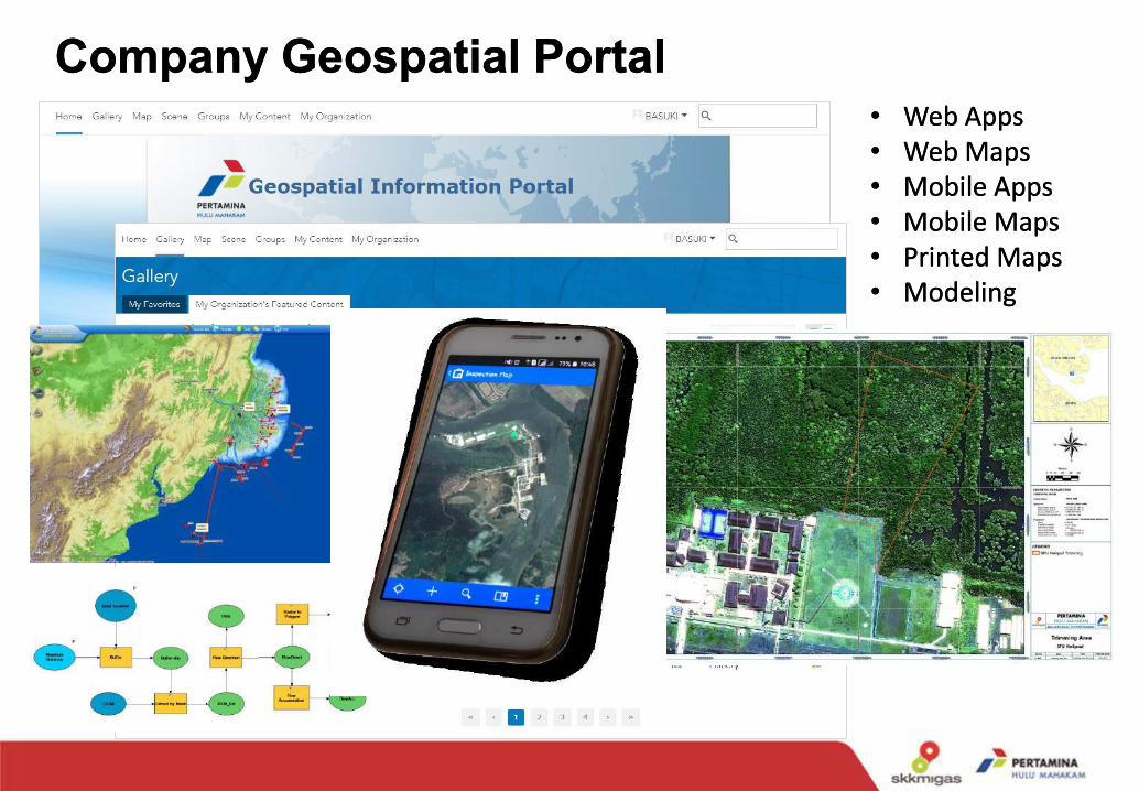
Company Geospatial PortalCompany Geospatial Portal •• Web AppsWeb Apps •• Web MapsWeb Maps •• Mobile AppsMobile Apps •• Mobile MapsMobile Maps •• Printed MapsPrinted Maps •• ModelingModeling

In New Well Planning:
Well surface location is a very complex planning to determined the optimized surface location to drill a new well within the operation area.
BenefitBenefit
With updated information of available well slot, production rate, bathymetry depth, surrounding villager, societal activities data;
The problems to be solved:
•Using existing well slot or create a new well platform?
• Rig access route along the rivers and narrow channel?
•New pipeline layout?
•Distance to target and Drilling trajectory plan?

BenefitBenefit
The real gain of the GIS Portal is related to the avoidance of the crash accesses. It gives a clear picture of the constraints and help to manage the risk and to take decision.
In Operation Planning: Planning of well service operation is a very complex activity in the operation area. Numerous crash accesses to location might occurred (impossibility of the well service barge to enter the location due to undetected on-going activity during the planning session).

In Safety Operation:
By having Work Permit and hazard displayed on the GIS Portal is helping Site Manager to control the work distribution and prevent potential conflicts works within the same area, as well as to locate operational risks in real time. The Site Manager can have a better and comprehensive view on each working activity and its risks and able to integrate the activity of, at least, 5 disciplines including Production, Inspection, Construction, Well Services, Marine and Project during daily meetings.
BenefitBenefit
Work Permit can be assessed if there is a conflict between several activities or if the activity that will be performed is nearby a hazard location.

In Environment Issue:
From time to time the environment and social challenges in Mahakam Estuary are become important aspects in ensuring the operation continuity. Since GIS portal was introduced to company in years ago, lately it has been widely used for improving environmental management in the field of oil spill response, air dispersion, environmental and biodiversity monitoring.
BenefitBenefit

In Vessel Tracking: To support the operation of Mahakam Block, Company operates more than 300 vessels with various type (LCT, Sea Bus, Sea Truck, Tug Boat, Speed Boat, Crew Boat, AHT and Fire Fighting boat) for logistic and crew movement, rig move, survey, drilling, inspection, construction, patrol etc. With area more than 2,800 square kilometers around Mahakam delta estuary, vessel's operation are very important to support all of the activities in Company operation's area.
BenefitBenefit
With analysis of Vessel tracking records, Company can:
• Reduce the travelling distance, and saving fuel consumption
• Deliver accident investigation report.

BenefitBenefit
In Field Survey Operation:
Field survey operation need the map either hardcopy or mobile map to get real time data in the field. Using mobile map can help surveyor easily to get data and reporting the field condition immediately.

In UAV Aerial Survey:
To get up-to-date aerial photo for detail analysis related with pipeline inspection, potential slide area, environment condition, forest rehabilitation area, etc.
BenefitBenefit

BenefitBenefit In Emergency Situation: When oil spill happen and identified from a pipeline near shore adjacent to village/shrimp ponds farm area, the management crisis team which is formed by different entities require a necessary information for their decision making, such as :
All of those are shown in “one window/screen” and able to be viewed by all sites and give required information in minimizing foot print from its operations and making decision in due time in emergency situation.
• Information of pipeline • Simulation of oil spill to locate possibility
impacted area • Position of all marine fleet (rigs, barges,
seismic vessel, speedboats, etc) being occupied in real-time, and their safe standby location.
• Updated and reliable map with detail topography, land cover, marine and weather, satellite imageries and biodiversity activities, etc
• Information of socio-economy-environmental of surrounding area and possibility impact on sensitive area, population affected and evacuation, legal issue, publication, medical or security intervention, etc.
• Location for oil spill boom deployment

ConclusionConclusion
This GIS Portal employs server web-based technology. Therefore, it enable thousands of distributed users to access centralized GIS enterprise database on map platform from their remote location without installing specific desktop application on their computer, with direct advantages are :
The data well-managed in databases, auditable and able to re-display; Reduce of data duplication Faster and comprehensive information to support operation and decision making; Simplify visualization of the emergency response strategy shall be taken in evacuation, mobilization, deployment and consideration of socio-economy-environmental impact. Paperless (green campaign and cost reduction)
This system empower GIS technology as “a portal web-based single-screen machine” in the enterprise level which is capable to provide all personnel in Company with a consolidated any digital databases using their desktop or mobile to query and process this source of information.

Thank You…