geospatial open data helps to improve public services | katerina harrington | march 2015
Upload: department-for-communities-and-local-government-local-digital-campaign
Post on 16-Jul-2015
78 views
TRANSCRIPT

Geospatial Open Data helps to improve public services
GEOSPATIAL OPEN
DATA HELPS TO
IMPROVE PUBLIC
SERVICES
Katerina Harrington
Public Sector Relationship
Manager
27 March 2015

I WILL COVER…
• An introduction to Geographic Information (GI)
• Open data examples
• Existing OS OpenData products
• New OS OpenData products
• Transparency Agenda obligations
• Questions
Geospatial Open Data helps to improve public services

GEOGRAPHIC INFORMATION (GI)
• GI or Geographic Data - is a collection of information that can describe
objects and things with relation to where they are located on the ground. OS
use x,y coordinates, longitudes and latitudes are also used.
• 100% of Local Authorities use GI!
• Most Local Authorities have in-house GI experts.
• To realise the benefits of GI you use a Geographic Information System. All
Local Authorities have a GIS.
• All Local Authorities strive to improve services, GI is helping to do so.
Geospatial Open Data helps to improve public services

CORNWALL COUNCIL’S SEAMLESS BASE-MAP IMPROVES
CUSTOMER EXPERIENCE
• ‘I don’t like the way the map changes
style as I zoom in and out’.
• Introduce greater consistency into
the mapping styled from vector
products
• A 15% switch of channel from phone
to web offers a potential saving of
£423,000 in one year.
http://www.ordnancesurvey.co.uk/business-and-
government/case-studies/cornwall-council-base-map-
customer-experience.html
Geospatial Open Data helps to improve public services

ORDNANCE SURVEY MAPS IMPROVE HEALTH CARE IN
NORTH ESSEX
• Ordnance Survey geographic
information underpins a local ‘stop
smoking’ programme. Demand has
increased by 300% since more
effective targeting of services has
been introduced.
• A pilot project was initiated to
improve the detection of
undiagnosed Chronic Obstructive
Pulmonary Disease (COPD) using
community pharmacies. Maps were
provided to the project team to assist
in identifying areas of high-risk
patients and optimally located
pharmacies to include in the
programme.
Geospatial Open Data helps to improve public services
http://www.ordnancesurvey.co.uk/business-and-
government/case-studies/north-essex-os-maps-
improve-health-care.html

OS OPEN DATA STACK
MiniScale
1: 250 000 Scale Colour Raster
Meridian2
Strategi
Vector Map District
OS Open Rivers
OS Open Roads
OS Open Map - Local
Boundaryline
OS Open Names
Codepoint Open
Terrain 50
View. Pin. Share
Geospatial Open Data helps to improve public services

MAPPING - MINISCALE
• Clean, simple and uncluttered
mapping, ideal for magazine and
brochure illustrations.
• Designed for desktop graphic
applications without the need for
more complex GIS.
• The mapping is ready for
customisation and conversion into
any graphic format, in particular
creating web images.
Geospatial Open Data helps to improve public services

CODE-POINT OPEN
• Enable users of your route-planning
application to enter postcodes as
their starting points and destinations
• Empower your website users to find
houses for sale in particular
postcodes
• Provide simple 'find my nearest'
mobile applications.
Geospatial Open Data helps to improve public services

OS Open Map - Local OS Open Rivers
OS Open Roads OS Open
Names
A new ‘street level’ vector dataset designed as an effective backdrop for integrating and visualising other analytical open data.
A generalised road network product delivering a national view of Great Britain’s road network.
A generalised network enabled product
delivering a national view of Great Britain’s
rivers.
A significant upgrade to our legacy
gazetteer products for use in location
searches on both mobile and web.
Geospatial Open Data helps to improve public services
BETA BETA
BETA

OS OPENMAP - LOCAL
• Provides a backdrop for
visualisation for mapping.
• Integrating analytical data such as
other Government information.
• High quality visual building detail
including important buildings.
• Includes extents of functional sites
such as hospitals and schools.
• Easy to use and simple to style in
accordance with your mapping
demands.
Geospatial Open Data helps to improve public services

ANALYSIS USING OS OPEN MAP - LOCAL
Geospatial Open Data helps to improve public services

OS OPEN ROADS
• OS Open Roads is a connected road
network for Great Britain.
• All classified roads included
(Motorway and A & B Roads)
• Includes officially named unclassified
roads
• Compatible with the road detail in
other OS OpenData products
Geospatial Open Data helps to improve public services

OS Open Names will:
• Enable quick and accurate
location searching by a
number of different criteria
• a structured index to
geographic names
• Link names across a variety
of media
Record attributes
OS OPEN NAMES – SIMPLE SEARCH SOLUTION
Geospatial Open Data helps to improve public services
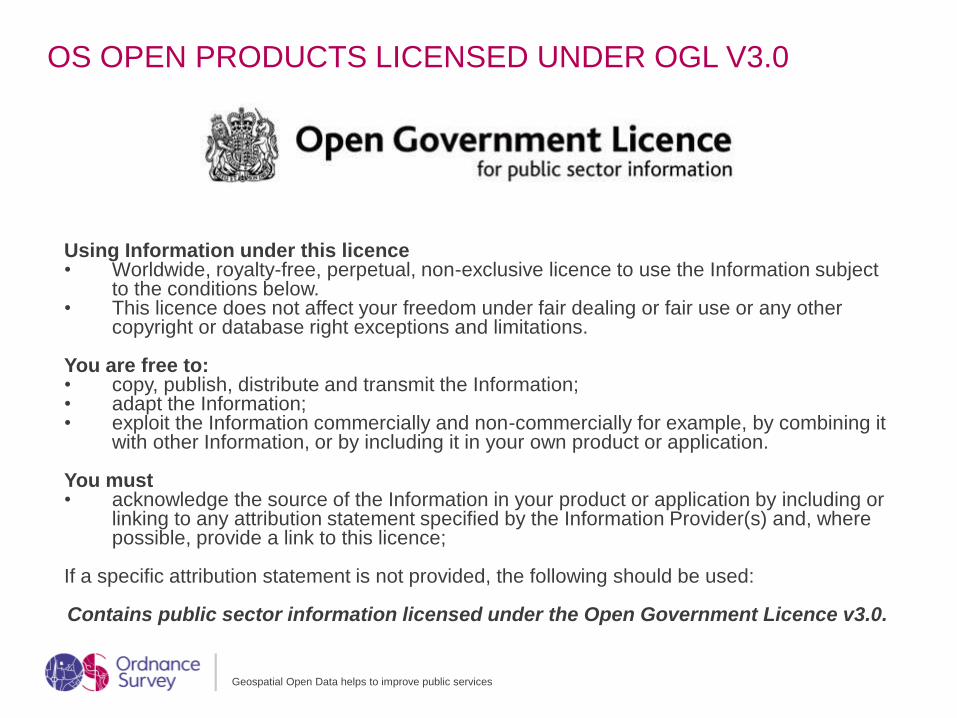
OS OPEN PRODUCTS LICENSED UNDER OGL V3.0
Geospatial Open Data helps to improve public services
Using Information under this licence• Worldwide, royalty-free, perpetual, non-exclusive licence to use the Information subject
to the conditions below. • This licence does not affect your freedom under fair dealing or fair use or any other
copyright or database right exceptions and limitations.
You are free to:• copy, publish, distribute and transmit the Information;• adapt the Information;• exploit the Information commercially and non-commercially for example, by combining it
with other Information, or by including it in your own product or application.
You must • acknowledge the source of the Information in your product or application by including or
linking to any attribution statement specified by the Information Provider(s) and, where possible, provide a link to this licence;
If a specific attribution statement is not provided, the following should be used:
Contains public sector information licensed under the Open Government Licence v3.0.

HELP MEET YOUR TRANSPARENCY AGENDA
OBLIGATIONS
• OS derived data has licensing implications.
However,
• The Unique Property Reference Number (UPRN) within your LLPG and
AddressBase data is now royalty free. This will help to meet your
Transparency Agenda obligations.
• Councils can publish their public asset data as open data with no OS
licensing restrictions.
Geospatial Open Data helps to improve public services

GOING FORWARD…
• OS OpenData is already used by many Local Authorities.
• Local Authorities are already seeing the benefits.
• But we would like to help more departments benefit from OS data.
• If you don’t know anything about GI but would you like to, contact me or your
in-house GI expert.
• Let us know how we can help further?
• www.os.uk/opendata
Geospatial Open Data helps to improve public services

QUESTIONS
Geospatial Open Data helps to improve public services
