geotaso project summary and relevance
TRANSCRIPT

GeoTASO Project Summary and Relevance
Jim Leitch
Ball Aerospace
303-939-5280
4/23/2013

Sensor Concept Overview
Page 2
• Airborne nadir-viewing wide-swath
imaging spectrometer
• Two channel spectrometer uses:
— 1st order diffraction for Visible
— 2nd order diffraction for UV
• Dichroic beamsplitter and spectral
filtering key elements in multi-order
design
• Polarization: Low polarization
sensitivity telescope and electronic
depolarizer for spectrometer
• Field-swappable spectrometer slits
to change spectral passband and
sampling

GeoTASO Status
• Airborne system
— Sensor, data collection/control system, zenith fiber port, and nadir port window form system
— Configured to fly on NASA’s Falcon HU-25C airplane
— Mount/window can be adapted for other platforms
• Flight data
— Have data from flight tests in Virginia and flight campaign in Houston (w/DISCOVER-AQ)
— Data (including viewing/solar information) available in HDF5 format
— Have data for a variety of scenes, different altitudes, different slit sizes, different times of day
• Calibration data
— Measurements mainly from testing at Goddard
— Calibration includes radiometric, polarization
— Working with algorithm team to improve Level 1b data
• NASA ESTO funded project close to completed:
— Demonstrated multi-order spectrometer for air quality measurements
— Fielded reconfigurable airborne system and collect real scene data
— Used data to test air quality retrieval algorithms

Key Optical Components Developed
Page 4
Offner spectrometer grating:
• Offner form of spectrometer ideal for spectral imaging, but needs convex, blazed grating
• Second attempt grating meets requirements: — High efficiency peaked at 310 nm
— Low scatter/ghosting
Spectral filtering:
• Needs good rejection of
unwanted wavelengths
3 panels
0
20
40
60
80
100
300 400 500 600 700 800 900
%T
Wavelength (nm)
Dichroic
measured
theoretical
Depolarizer/Changeable slit assy:
• Electronic depolarizer from
PolZero ACT project
• Precision-registered slit holder
for field slit swaps
Page 5
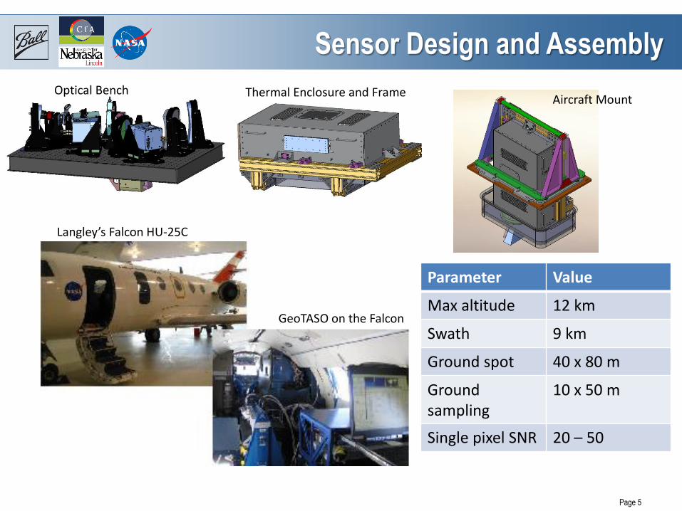
Sensor Design and Assembly
Optical Bench Thermal Enclosure and Frame Aircraft Mount
Langley’s Falcon HU-25C
GeoTASO on the Falcon
Parameter Value
Max altitude 12 km
Swath 9 km
Ground spot 40 x 80 m
Ground sampling
10 x 50 m
Single pixel SNR 20 – 50

Flight Campaign Overview
Page 6
OMI underflight
• July test flights over VA and Chesapeake Bay — Land/water and
urban/rural sites
— Overflight of Langley ground site
— Duplicated ACAM test flight path
• September Houston campaign: — Coflights with B200
(ACAM and HSRL) over urban sites
— Coflight with B200 over Gulf out to GeoCAPE boat
— Different slit widths on different days
— Tested depolarizer effect over land/water
Transit back: urban areas, NC power plants
Transit out: urban areas, GA power plants
DISCOVER-AQ coflights: diff passbands
GeoCAPE coflight: ocean color
Test flights
• 32 total flight hours of data

Flight Data and Retrieval Highlights
Page 7
NO2 slant columns measured over Houston on 24 September 2013 at ~500 × 500 m resolution. GeoTASO flew the same ground tracks as the DISCOVER-AQ team to enable direct comparisons. (courtesy Caroline Nowlan, SAO)
NO2 slant columns measured over North Carolina’s three largest coal power plants on 24 September 2013 at ~500 × 500 m resolution during flight home from Houston to NASA Langley. (courtesy Caroline Nowlan, SAO)
GeoTASO flew over the Gulf out to the Geo-CAPE ocean study boat (seen in the GeoTASO image). A proposal from OSU to analyze the data has been submitted. (courtesy Curt Davis, Oregon State)
Closeup of the Roxboro Steam Plant NO2 plume. GeoTASO measured enhanced NO2 >40 km downwind of the plant.(courtesy Caroline Nowlan, SAO)
Surface reflectance studies tie radiance levels to features like trees (blue) and green grass (yellow-green) to develop a spectral reflectance model. (courtesy Jun Wang, U Nebraska)

Initial Spectral Signal Measurements
Measured spectral signal close to predictions
Page 8
Nadir view radiance (over forest)
Predicted signal

Algorithm Overview
• Aerosols and surface reflectance
• Specific bands of interest identified and flight data examined
• Comparison of model-predicted radiance and measured radiance shows
need for absolute radiance calibration of the visible channel
• Trace gas pollutants:
• NO2 retrievals using flight and zenith sky data from 420nm to 460nm
show high sensitivity
• HCHO retrievals using 330-360 nm show need for better fixed pattern
calibration/characterization of UV channel
• Instrument characterization
• Line shape
• Wavelength calibration
Page 9 5/13/2014

Upcoming GeoTASO Activities
• Calibration and data processing at Ball
— Characterize UV stray light
— Use Ball calibration sphere for full field radiometric
calibration
— Reprocess flight data with new calibration values
— Lineshape scans using tunable laser (funds permitting)
• Flight planning and campaigns
— Flying July 23 – Aug ? on Falcon in Front Range area of
Colorado with DISCOVER-AQ and FRAPPE campaigns
(59 hrs flight time funded)
1. Coincident D-AQ tracks overflying B-200 with ACAM
for data validation
2. Diurnal studies flying D-AQ flight tracks with two
sorties per day for morning-midday-afternoon-evening
comparisons
3. GEO-CAPE atmosphere retrieval studies: low pass
and high pass over same site to validate ground return
subtraction from retrievals. Perform over different
terrain types - plains, vegetated forest, urban, foothills.
4. Raster scans over Denver for AQ map.
Page 10 5/13/2014