geotechnical characterization of foundation preparation practices
TRANSCRIPT
8/12/2019 Geotechnical Characterization of Foundation Preparation Practices
http://slidepdf.com/reader/full/geotechnical-characterization-of-foundation-preparation-practices 1/4
Proceedings of Indian Geotechnical Conference
December 15-17, 2011, Kochi (Paper No.Q-077)
GEOTECHNICAL CHARACTERIZATION OF FOUNDATION PREPARATION PRACTICES
IN EARTH AND ROCK FILL DAM- A CASE STUDY
Praveen Kumar Yadav, DGM (FES), KOLDAM HEPP, NTPC Ltd, E-mail: [email protected] Rama Krishna Adhikari, Manager (Geology), KOLDAM HEPP, NTPC Ltd,E-mail: [email protected] Pratik Roy, Sr. Geologist, KOLDAM HEPP, NTPC Ltd, E-mail: [email protected]
ABSTRACT:
The Kol Dam Project (800MW), NTPC’s first voyage into hydroelectric power project under construction, a
167m high Earth and Rock fill dam across Satluj River, is situated in a Karstic terrain. Geotechnical characterization of
foundation mainly depends upon the type of rock, frequency of discontinuities and structure to be built on that area. Surface preparation included excavating overburden; surface cleaning, shaping the foundation surface with dental concrete; treating
faults, shears, or weak zones; filling up of joints with cement mortar etc. Besides surface treatments curtain grouting and
consolidation grouting were also provided as per geological condition of the area concerned for creating seepage barrier and
strengthening the strata. This paper presents the different methods adopted to achieve safety and constructional advantage in
foundation preparation in the Dam body of Kol Dam project.
INTRODUCTION
Kol Dam (location 31°23’N, 76°52’E) in Bilaspur District,
Himachal Pradesh, NTPC’s first voyage into hydro project is
an Earth and rock fill Dam across Satluj, situated about 6 kmupstream of Dehar Power House (Beas Satluj link project).
Main structures of Kol Dam projects are two diversion
tunnels of 14m finished diameter and 900 (appx.) length each,
a 108.5m wide and 0.42 km long chute spillway and a surface power house of 800(4x200) MW capacity. The Kol Dam
project has been basically designed as a run-of-the-river
hydro power development scheme with advantage of
additional storage for the first 30 years.
The 167 m. high (above deepest foundation level at El 481)
and 500 m. long (at crest) rock and gravel fill Kol Dam with
impervious central clay core to provide a live storage of 90million cum. (9000 ha. m.) between full reservoir level (FRL
at El 642) and Minimum Draw Down Level (MDDL at El
636). This paper presents the different techniques/ practicesadopted to achieve safety and constructional advantage in
foundation preparation in Main Dam area of Kol Dam
project.
BRIEF GEOLOGY OF THE PROJECT AREA
The rocks belonging to Shali, Shimla, Sundernagar Groups
and Mandi Darla volcanic constitute the area. The dolomite ofTatapani, Limestone of Sorgarwari (Shali Group) and
phyllites of Basantpur formation with basic intrusive are themajor lithological units exposed at the locations of major
components of the Kol Dam project (Sanjiv Kumar 2005-06).
In addition two generations of terrace materials are also
present in the project area one is simple river borne terrace
material composed of loose river borne materials like
boulders of Quartzite including the material coming from the
rocks present near the dam site and the other one is terrace
material composed of boulders, pebbles and gravel,
essentially made of quartzite, limestone, dolomite and basicrock (all the rock materials that present outcrops near the dam
site), in a sandy and highly cemented calcareous matrix. The
rock encountered at the Dam foundation is Limestone,
Dolomite and Limestone-Dolomite transition zone.
Detailed geological mapping of the Main Dam foundation
area has been carried out in 1:100 scale. Pink limestone unit
(Sorgharwari Formation), transition zone and Upper dolomiteunit (Tatapani Formation) with thin (1 to 10 cm thick) shale
interbeds are exposed in the Dam foundation and abutments.
The general trend of bedding joint recorded is N100W- S100E,
which is nearly 200 askew to Dam axis, with 70-800 dip duesouthwest direction. Due to the disposition of bedding the
transition zone crosses the core foundation from left to right
abutment. The Limestone-Dolomite transition zone in theDam base foundation & abutment carries numerous open
joint networks, solution cavities, sand pockets and small
sinkholes. A number of erosional cavities formed partly by
solution activities and may be by churning actions has also
been observed while doing the geological mapping. Two
principal families of stress relief joints have been observed
along riverbanks near the dam site; both are striking parallelto the river, the first one consists of joints parallel to the
abutments slope (dipping 30 to 70° towards the river) and thesecond one consists of joints, dipping perpendicularly to the
valley dipping joints. The rock is affected by a minor joint
pattern (in a first approach, two main joint families). Both
families are striking perpendicular to the bedding; the first
one is dipping approximately 50-60° NW, and the other one is
1003
8/12/2019 Geotechnical Characterization of Foundation Preparation Practices
http://slidepdf.com/reader/full/geotechnical-characterization-of-foundation-preparation-practices 2/4
Praveen Kumar Yadav, Rama Krishna Adhikari & Pratik Roy
dipping about 50-60° SE. The broken surfaces usually present
a certain roughness. These joints can present an extensionranging from some dozen centimeters to some meters. Some
cavities (1 to 3m diameter) have also been surveyed during
the Geological mapping on both abutments.
FOUNDATION PREPARATION AT KOL DAMThe foundation preparation practices in Kol Dam Hydro
electric power project has been characterized into three
different categories such as Slope modifications, FoundationGrouting and Surface Foundation Treatment.
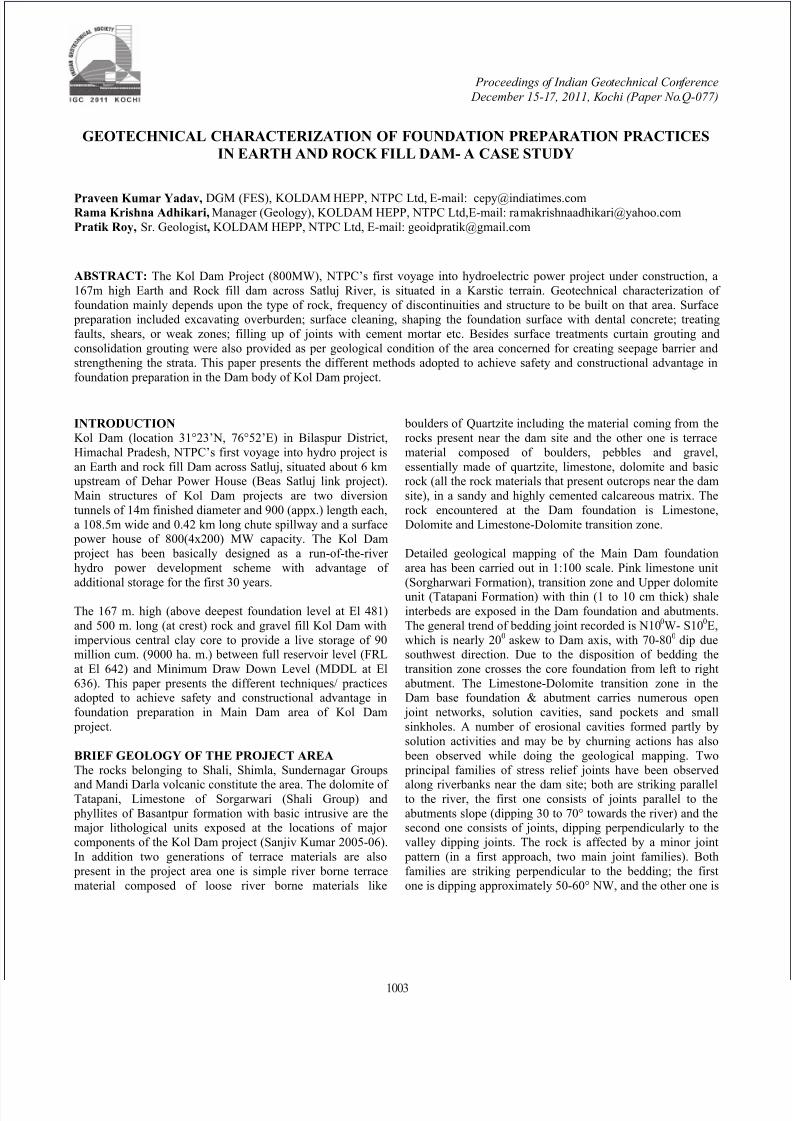
Slope Modifications To allow earth fill to be compacted and maintain positive pressure on the abutments, foundation surfaces in both
abutments in Main Dam Clay Core, in particular, has been
flattened to about 0.73:1 to 1.75:1(H:V)in Left abutmentwhile 0.87:1 to 4.45:1(H:V) in the Right abutment (Clay Core
Area) by excavation (NTPC-EDF 2002)(Fig. 1).
Fig.1 Slope modification to reduce differential settlement &cracking of core (Sanjiv Kumar 2005)
Foundation GroutingThe principal purpose of grouting is to fill openings in a
foundation and render it impervious to percolating water. It is
also used to improve the strength and elastic properties of the
foundation material into which it is injected. Themethodology of grouting given to the foundation materials as
a whole has been decided depending upon the available
geological formations and features in the near vicinity of Dam
site. Grouting with normal cement grout is also doubtfulvalue in rocks where permeability value results from a great
number of fine cracks. With normal cement grout it is not
possible to seal cracks which have width much finer than
0.2mm. In Kol Dam as the carbonate sedimentary rock like
limestone and dolomite are inherited by very fine as well asopen joint networks different fillers/accelerators/admixtures
were incorporated in both curtain and consolidation groutingwith variable C:W ratios. The grout mix for all the grouting
operations in Kol Dam has been designed depending upon the
existing site geology. The grouting operation has been carriedout with a variety of grout mixes starting C/W ratio 0.35:1 to
0.6:1 with different admixtures like bentonite, accelerators
like micro silica etc depending upon the geology encountered.The spacing and the pattern of grout holes has been designed
based on several test sections carried out on the basis of
acceptable permeability of the foundation and the nature of
the Dam. In the test sections different grout materials with
variable C/W ratio were also analyzed for suitability byobserving the performance in terms of viscosity, decantation
and compressive strength. The grout performance in terms of
lugeon value, viscosity, decantation, compressive strengthand ground upheaval were analyzed for achieving the design
criteria. The treatments provided as per encountered geology
has been found satisfactory even during the heavy monsoon.
In addition, as a measure of foundation safety in Kol Dam, 5no. of drainage galleries are also provided to drain off the
seepage water and thus reduce the uplift pressure in the
abutments which will act after the reservoir impounding.Foundation grouting adopted in Kol Dam are mainly in two
forms:
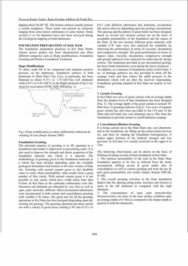
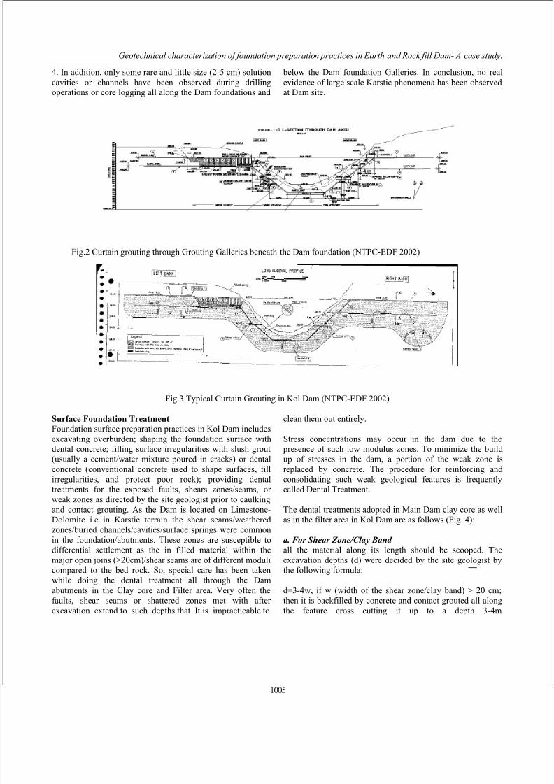
1. Curtain Grouting In Kol Dam two rows of grout curtain with an average depthfrom the deepest level of dam foundation has been designed
(Fig. 3). The average depth of the grout curtain is around 70-
80m from 12 grouting Galleries (Fig.2). Two rows of separategrout curtain has also been provided in the U/S part of the
Main dam left bank clay core abutment (up to 30m from the
foundation) to provide curtain to cutoff/minimize seepage.
2. Consolidation/Blanket Grouting It is being carried out in the Main Dam clay core abutmentsand in the foundation, for filling up the joints/cracks/crevices
etc. and there by making the foundation homogeneous. It
makes upper portions of the bedrock stronger and less pervious. In Kol dam it is usually restricted to the upper 6 to
12m.
The following observations can be drawn on the basis of
Drilling-Grouting records of Dam foundation in Kol Dam:1. The intrinsic permeability of the rock in the Main Dam
foundation appears to be low as inferred from the strata
encountered, drilling record & grout intake data ofconsolidation as well as curtain grouting and from the pre &
post grout permeability test results (Sanjiv Kumar 2005-06,
07-08).
2. The overall grouting activities in the Dam foundationdepicts that the opening along joints, fractures and fissures is
more in the left abutment as compared with the rightabutment.
3. The concentration of open joint networks/finefissures/cavities are more in the near surface condition upto
an average depth of 6-10m as compared to the deeper depth in
general in both the abutments.
1004
8/12/2019 Geotechnical Characterization of Foundation Preparation Practices
http://slidepdf.com/reader/full/geotechnical-characterization-of-foundation-preparation-practices 3/4
Geotechnical characterization of foundation preparation practices in Earth and Rock fill Dam- A case study.
4. In addition, only some rare and little size (2-5 cm) solution
cavities or channels have been observed during drillingoperations or core logging all along the Dam foundations and
below the Dam foundation Galleries. In conclusion, no real
evidence of large scale Karstic phenomena has been observedat Dam site.
Fig.2 Curtain grouting through Grouting Galleries beneath the Dam foundation (NTPC-EDF 2002)
Fig.3 Typical Curtain Grouting in Kol Dam (NTPC-EDF 2002)
Surface Foundation Treatment Foundation surface preparation practices in Kol Dam includes
excavating overburden; shaping the foundation surface withdental concrete; filling surface irregularities with slush grout
(usually a cement/water mixture poured in cracks) or dental
concrete (conventional concrete used to shape surfaces, fill
irregularities, and protect poor rock); providing dentaltreatments for the exposed faults, shears zones/seams, or
weak zones as directed by the site geologist prior to caulking
and contact grouting. As the Dam is located on Limestone-
Dolomite i.e in Karstic terrain the shear seams/weatheredzones/buried channels/cavities/surface springs were common
in the foundation/abutments. These zones are susceptible to
differential settlement as the in filled material within themajor open joins (>20cm)/shear seams are of different moduli
compared to the bed rock. So, special care has been taken
while doing the dental treatment all through the Dam
abutments in the Clay core and Filter area. Very often the
faults, shear seams or shattered zones met with after
excavation extend to such depths that It is impracticable to
clean them out entirely.
Stress concentrations may occur in the dam due to the presence of such low modulus zones. To minimize the build
up of stresses in the dam, a portion of the weak zone is
replaced by concrete. The procedure for reinforcing and
consolidating such weak geological features is frequentlycalled Dental Treatment.
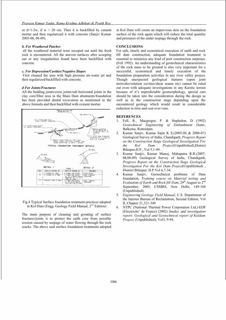
The dental treatments adopted in Main Dam clay core as well
as in the filter area in Kol Dam are as follows (Fig. 4):
a. For Shear Zone/Clay Band
all the material along its length should be scooped. Theexcavation depths (d) were decided by the site geologist by
the following formula:
d=3-4w, if w (width of the shear zone/clay band) > 20 cm;
then it is backfilled by concrete and contact grouted all along
the feature cross cutting it up to a depth 3-4m
1005
8/12/2019 Geotechnical Characterization of Foundation Preparation Practices
http://slidepdf.com/reader/full/geotechnical-characterization-of-foundation-preparation-practices 4/4