geotechnical report - parks highway mp 44-52 · and laboratory test procedures, and results of the...
TRANSCRIPT
Matanuska-Susitna Borough
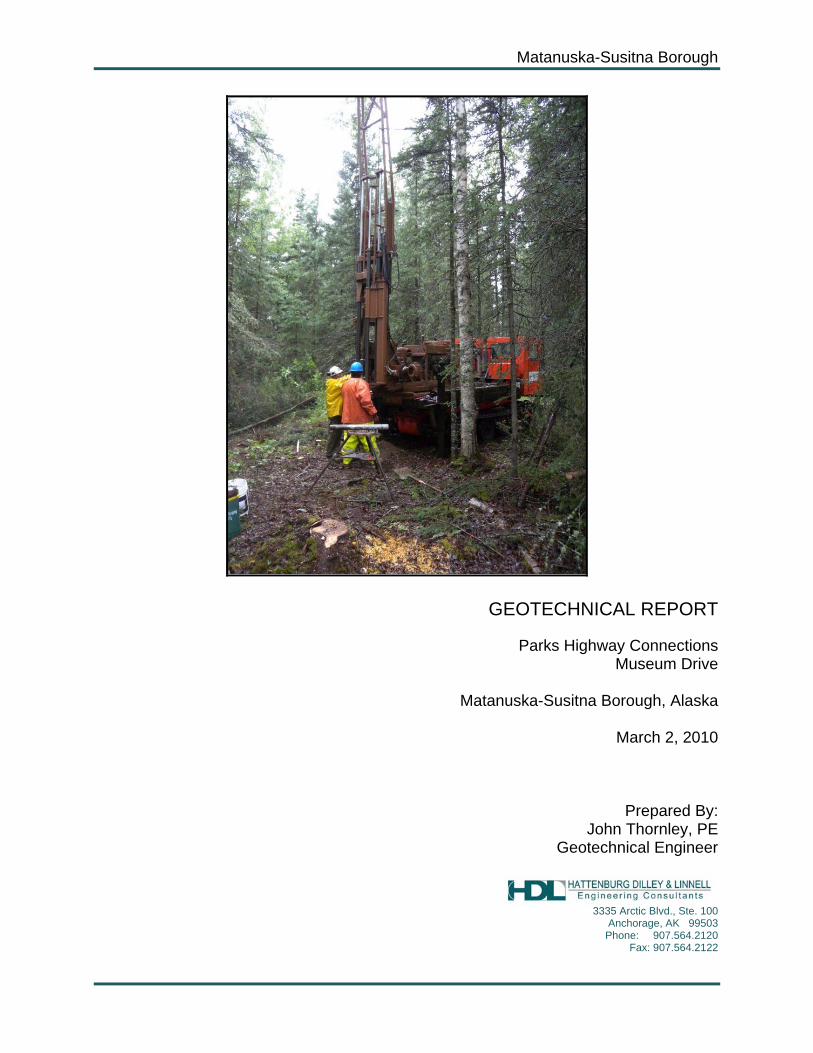
GEOTECHNICAL REPORT
Parks Highway Connections Museum Drive
Matanuska-Susitna Borough, Alaska
March 2, 2010
Prepared By: John Thornley, PE
Geotechnical Engineer
3335 Arctic Blvd., Ste. 100
Anchorage, AK 99503 Phone: 907.564.2120
Fax: 907.564.2122

TABLE OF CONTENTS 1.0 INTRODUCTION ...................................................................................... 1
2.0 SITE AND PROJECT DESCRIPTION ....................................................... 1
3.0 LOCAL CONDITIONS ............................................................................... 2
3.1 GENERAL GEOLOGY ................................................................................. 2 3.2 SEISMICITY ............................................................................................... 2 3.3 CLIMATOLOGY .......................................................................................... 3
4.0 FIELD STUDY ...................................................................................... 3
5.0 LABORATORY TESTING ......................................................................... 4
6.0 SUBSURFACE CONDITIONS ................................................................... 5
6.1 GROUNDWATER AND SURFACE WATER ...................................................... 5 6.2 SOILS ...................................................................................................... 5
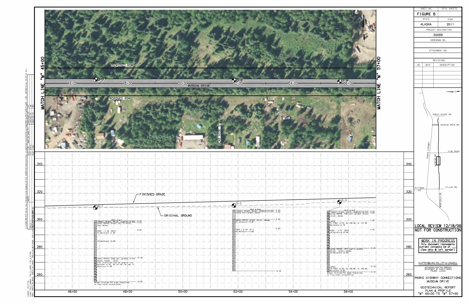
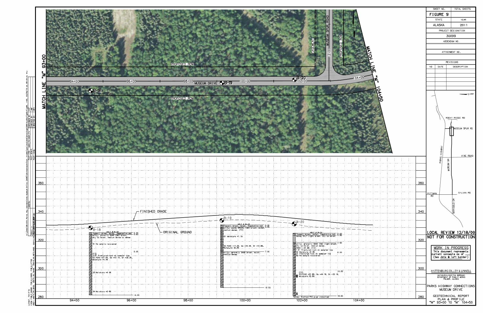
6.2.1 Borings B-1 Through B-9 (Station 10+00 to 56+00) ................................. 6 6.2.2 Borings B-10 Through B-12 (Station 56+00 to 71+50) ............................. 6 6.2.3 Borings B-13 Through B-20 (Station 71+50 to 104+00) ........................... 7 6.2.4 Peat Deposits (Station 104+00 to 109+00) ................................................ 7
7.0 CLOSURE AND LIMITATIONS ................................................................. 8
LIST OF FIGURES Figure 1 Vicinity Map Figure 2-10 Plan and Profile Sheets Figure 11 Peat Depth Contour Map LIST OF APPENDICIES Appendix A Figure A1 Unified Soil Classification Figure A2 Frost Design Soil Classification Figure A3-A22 Boring Logs Figure A23-A26 Grain Size Curves

Geotechnical Report Museum Drive Extension Matanuska-Susitna Borough
Page 1
GEOTECHNICAL REPORT PARKS HIGHWAY CONNECTIONS
MUSEUM DRIVE MATANUSKA-SUSTINA BOROUGH
ALASKA
1.0 INTRODUCTION This report presents the results of subsurface explorations and laboratory testing for the proposed Parks Highway Connections Museum Drive Project. The purpose of the field exploration and geotechnical studies was to define the soil and groundwater conditions for use in the design of the new roadway. To develop the criteria for use in design, 20 borings were advanced along the proposed alignment of the new road. Soil samples recovered from the borings were classified in the field by an experienced engineer with Hattenburg Dilley and Linnell, LLC (HDL) and returned to our laboratory for testing and verification. The project investigation was performed in general accordance with the procedures outlined in the “Alaska Geotechnical Procedures Manual” (ADOT&PF, 2007). Included in this report are a description of the project, subsurface exploration methods and laboratory test procedures, and results of the subsurface exploration and laboratory tests. A supplemental letter titled “Geotechnical Recommendations for Parks Highway Connections: Museum Drive”, March 2010, addresses the recommendations for design and construction for the project. The alignment description and subsurface conditions presented herein are based on our current understanding of the alignment and project as of the date of this document. Deviation from the alignment outlined within this report may require further evaluation of subsurface conditions. This report documents subsurface geotechnical conditions and provides analyses and interpretation of anticipated site conditions for the project. This report establishes a geotechnical baseline to be used in assessing the existence and scope of changed or differing site conditions. This report is intended for use by the project design engineering staff, construction personnel, bidders, and contractors.
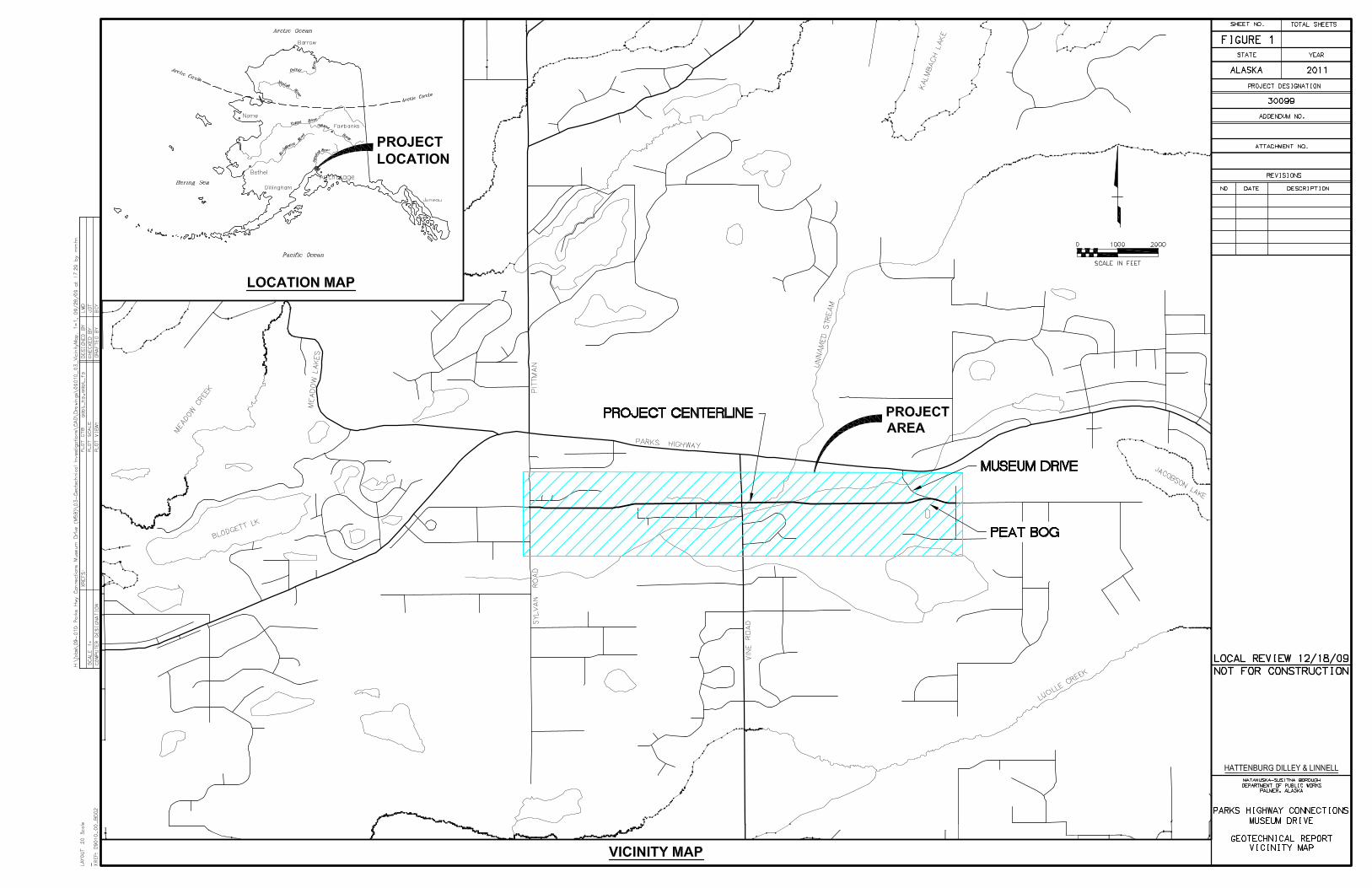
2.0 SITE AND PROJECT DESCRIPTION This project covers the development of an approximately 1.9-mile section of roadway connecting the existing Museum Drive to the east and Sylvan Road to the west, within the Matanuska-Susitna Borough. The location of the project is shown on the vicinity map in Figure 1. It is planned that this new connection, running roughly parallel to the

Geotechnical Report Museum Drive Extension Matanuska-Susitna Borough
Page 2
Parks Highway, will provide alternate routes for local access. The new road is classified as a collector connection. The purpose of this road extension project is to improve the collector connections within the local roads west of Wasilla as growth in this area continues. It has been estimated that development of connectors like this one will enhance local traffic mobility and safety. This connector will also reduce the vehicle-miles traveled and left turn movements onto the Parks Highway. The proposed road alignment will likely cross one stream at two locations located east of Vine Road. There is also a peat bog region at the eastern end of the alignment at the future connection with Museum Drive. These features are identified on the plan and profile sheets along with the boring locations on Figures 2 through 10.
3.0 LOCAL CONDITIONS
3.1 General Geology The project area is located within the Cook Inlet-Susitna Lowland Section of the Coastal Trough physiographic province of Alaska. The Talkeetna Mountains border the province on the east and the Alaska Range lies to the north and west. To the south is Cook Inlet. Glacial features including ground moraines, drumlins, eskers, and outwash plains characterize the entire Cook Inlet-Susitna Lowlands. Kame and kettle topography, indicative of glacial outwash plains, is common and forms many of the hills and small rounded lakes that exist in the project area. Five major glacial advances of the Quaternary Period can be recognized throughout the vicinity ending approximately 12,000 years ago. Sediments are typically glacial derived sands and gravels with varying fines contents. Peat bogs have developed in many of the low-lying areas subsequent to the last glaciation. As the glaciers receded towards the mountains, the Susitna River drainage was established as well as the drainages in the project area. These drainages deposited sands and gravels in channel areas and fine grain sediment in floodplains.
3.2 Seismicity The project is located in an area of moderate seismicity. Large-scale earthquakes may cause ground ruptures along the roadway. Locations of potential rupture zones are outside the scope of this study and are extremely difficult to predict. Slopes and structures such as bridges and culverts along the road should be designed to accommodate large-scale earthquakes. Based on Alaska Earthquake Information Database there were 399 events above magnitude 4 in the region from 1898 to 2005. There were 49 events above a magnitude 5 of which 14 were magnitude 6 to 7.4. The

Geotechnical Report Museum Drive Extension Matanuska-Susitna Borough
Page 3
2006 International Building Code places the area in Site Class D based on general soil properties encountered along the alignment.
3.3 Climatology The project area is located in a transitional climatic zone varying between continental and maritime climates. The zone is characterized by pronounced diurnal and annual temperature variations, moderate annual precipitation, and moderate surface winds. Average January temperatures in the area range between –2ºF and 19ºF, while average July temperatures range between 44ºF and 68ºF. The area experiences an average of 60 wet days per year in which 0.1 inch or more of precipitation accumulates. The Environmental Atlas of Alaska provided the information for the project area. Following are mean annual values for the area: Mean Annual Temperature 30ºF Mean Annual Precipitation 25 in. Mean Annual Snowfall 100 in.
Thawing Index 3000 degree days Freezing Index 3500 degree says
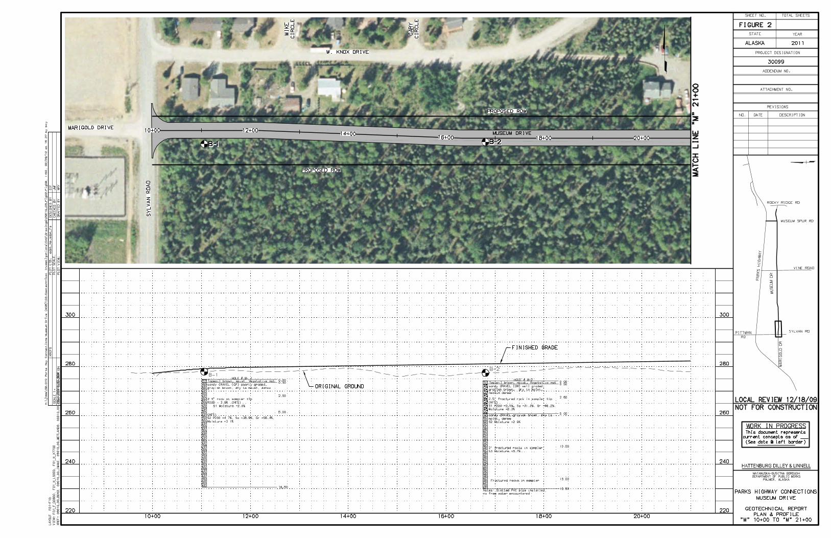
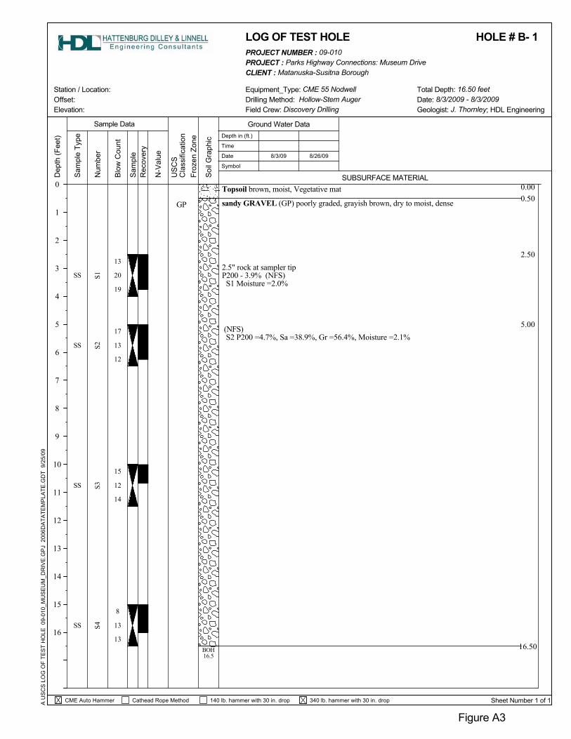
4.0 FIELD STUDY The geotechnical field study consisted of soil borings and peat probing. The intent of the field study was to determine the soil properties of the existing soils along the alignment. In all, 20 soil borings were each advanced to a depth of 16.5 feet below the existing ground surface. Locations of the 20 borings are detailed on Plan and Profile sheets located in Figures 2 through 10. The boring locations were typically spaced at 500-foot intervals along the proposed alignment. The borings for this study were advanced between August 3 and August 6, 2009. One-inch diameter slotted PVC pipe was installed in 10 select borings for monitoring groundwater levels along the alignment. The water levels in these borings were measured August 26, 2009, approximately 20 days after drilling was completed, which allowed for seasonal static water levels to become stabilized. Discovery Drilling Inc. of Anchorage, Alaska provided drilling services for this project using a CME 55 mounted on a Nodwell track vehicle. The borings were advanced with 3¼-inch inside diameter (I.D.) hollow stem auger. In each of the borings, split-spoon samples were collected at typically 2.5 feet, 5 feet, and 5-foot intervals thereafter. Sampling with the split-spoon was conducted using the Modified Penetration Test procedure. In the Modified Penetration Test, samples are recovered by driving a 3-inch O.D. split-spoon sampler into the bottom of the advancing hole with blows of a 340-lb. hammer free-falling 30 inches onto the drill rod. The number of blows required to advance the sampler the final 12 inches of an 18-inch penetration in the test is termed

Geotechnical Report Museum Drive Extension Matanuska-Susitna Borough
Page 4
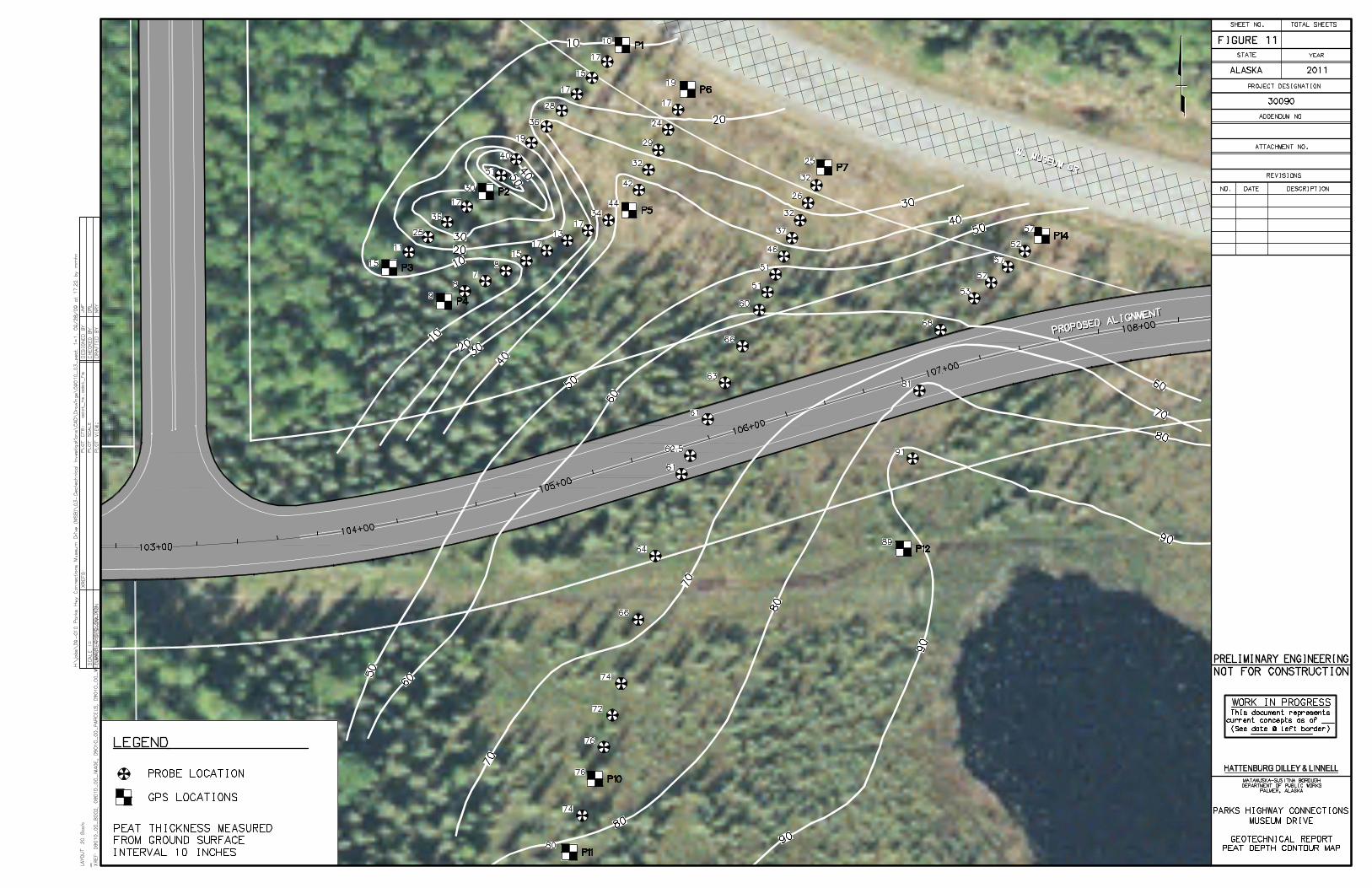
the Penetration Resistance, which was recorded for each sample depth. The values give a measure of the relative density (compactness) or consistency (stiffness) of cohesionless or cohesive soils, respectively. An experienced engineer from HDL was present continuously during drilling to locate the borings, observe drilling action, collect samples, log subsurface conditions, monitor groundwater encountered, and observe installation of groundwater monitoring equipment. The soils were classified in the field according to the Unified Soil Classification System (USCS) presented in Appendix A, Figure A1 and later verified by laboratory tests. A modified version of the U.S. Army Corps of Engineering Frost Design Soil Classification, presented in Appendix A, Figure A2, was used to estimate the frost characteristics of the soils based on the laboratory results. Detailed logs of the borings are presented on the plan and profile sheets in Figures 2 through 10 and in Appendix A, Figures A3 through A22. Peat probing was also performed during this geotechnical field study. The probing consisted of pushing a thin steel rod with T-handle into the regions along the alignment where peat deposits were apparent. The probe was pushed until the rod tip met refusal on firm underlying materials. The depth of probe penetration was measured and recorded. A peat depth contour map presented in Figure 11, was created for areas where peat deposits were measured.
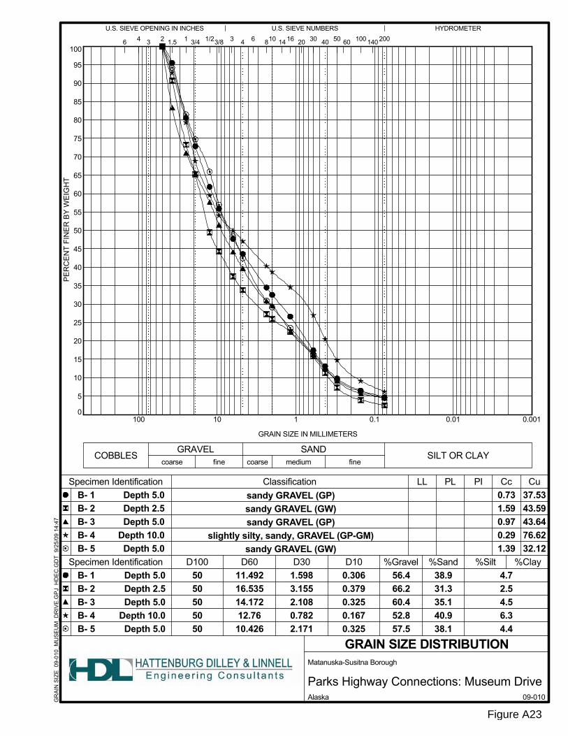
5.0 LABORATORY TESTING Laboratory tests were performed on select samples recovered from the borings to verify field classifications and to determine the pertinent soil properties and behavior characteristics of the typical materials encountered along the alignment. Testing was conducted by HDL’s AASHTO certified soils laboratory. The laboratory testing was formulated with an emphasis on determining the materials classification, moisture content, and frost characteristics. The soils were classified in the field and later confirmed by laboratory testing. A total of 52 moisture content tests were performed on samples from the 20 borings. These tests were conducted in accordance with procedures described in ASTM D-2216. The results of the moisture content measurements are presented on the boring logs presented in Appendix A, Figures A3 through A22. Grain size classification tests for this project consisted of 20 mechanical sieve tests and eleven P200 tests. The results were used to verify material classification, estimate permeability characteristics, and determine frost susceptibility of the soils. The mechanical sieve tests were conducted according to procedures described in ASTM D-422. The P200 tests were conducted according to procedures described in ASTM D-

Geotechnical Report Museum Drive Extension Matanuska-Susitna Borough
Page 5
1140. The results of the mechanical sieves and P200 tests are presented on the boring logs presented in Appendix A, Figures A3 through A22. The grain size curves are presented in Appendix A, Figures A23 through A26.
6.0 SUBSURFACE CONDITIONS The subsurface conditions along the alignment are depicted on the plan and profile sheets in Figures 2 through 10 and on the boring logs presented in Appendix A, Figures A3 through A22. The soils encountered were typically sands and gravels with varying amounts of fines. Peat deposits were found at the eastern portion of the alignment, adjacent to the existing Museum Drive, in the wetlands area.
6.1 Groundwater and Surface Water Groundwater was encountered in some borings near stream crossings, wetlands, and other areas that had perched water tables. The groundwater was found to be shallow enough to potentially affect the roadway embankment at two sections of the alignment Station 63+00 to Station 72+00 and Station 104+00 to Station 109+00. Groundwater was not found at shallow enough depth to potentially affect the roadway embankment along the rest of the project alignment. Slotted one-inch diameter PVC pipe was installed in 10 of the 20 borings. Groundwater levels were measured in these ten locations approximately 20 days after installation to allow for groundwater stabilization. Free water was observed in 3 of the borings during the time of drilling. Table 6.1 shows the measured groundwater depths in select borings during drilling and 20 days following drilling. Table 6.1 Measured Groundwater Levels
Boring Number Depth to Groundwater (ft)
During Drilling 20 Days After Drilling B-10 Not Observed 16.0 B-11 12 No PVC Installed B-12 11 9.6 B-20 16 11.5
Surface water was observed in two sections along the alignment. There was a small stream encountered on the east and west sides of Vine Road between Station 61+00 and Station 72+00. Also, surface water was observed the eastern end of the alignment at Museum Drive, the area where peat probing was performed.
6.2 Soils The following discussions of the geotechnical conditions for the project are organized into segments based on subsurface similarities along the alignment. Section 6.2.1

Geotechnical Report Museum Drive Extension Matanuska-Susitna Borough
Page 6
discusses the soils encountered in Borings B-1 through B-9 between the west end of the alignment at Sylvan Road and 650 feet west of Vine Road (Station 10+00 to 56+00). Vine Road is at approximately Station 63+00. Section 6.2.2 discusses the soils encountered in Borings B-10 through B-12, east of Vine Road (Station 56+00 to 71+50). Section 6.2.3 discusses the soils encountered in Borings B-13 through B-20, 1,100 feet east of Vine Road to 600 feet east of Museum Drive (Station 71+50 to 104+00). Section 6.2.4 discusses the peat probing results obtained from the roadway alignment section between Boring B-20 and Museum Drive (Station 104+00 to 109+00). The majority of the project will consist of fill to bring the road to finished grade. A slight cut occurs from Station 76+00 to 78+00.
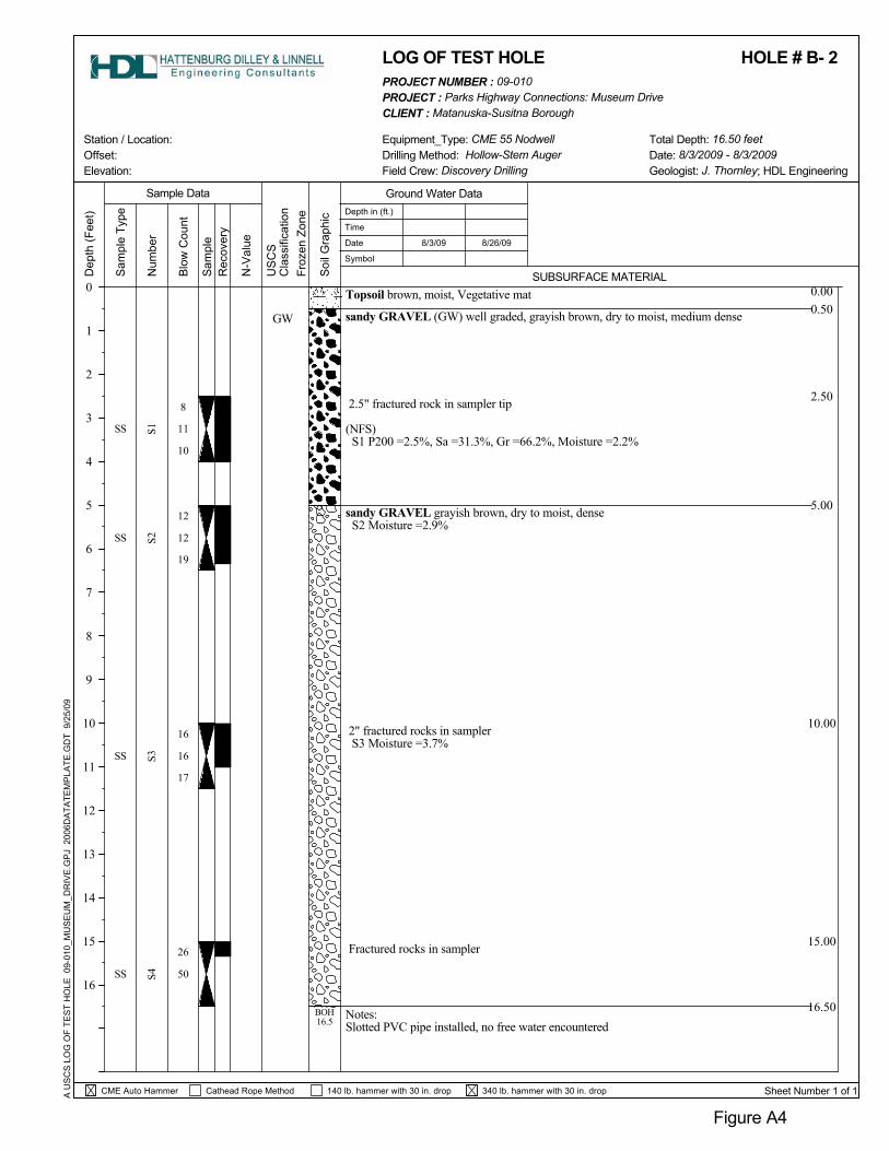
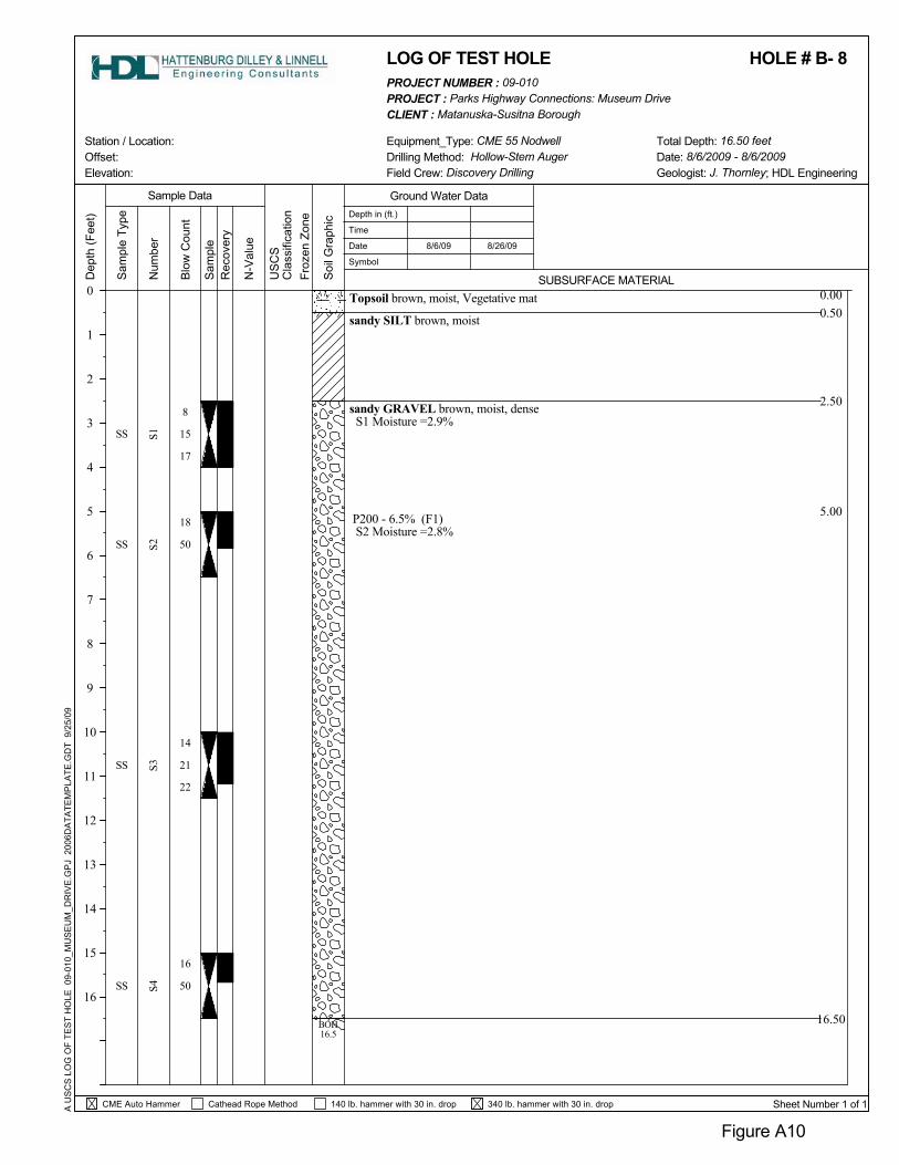
6.2.1 Borings B-1 Through B-9 (Station 10+00 to 56+00) The soils encountered in Borings B-1 through B-9 (Figures 2 through 5 and A3 through A11), between Sylvan Drive and Vine Road, are relatively similar in soil composition. There is a vegetative mat consisting of organics with tree roots in the upper 0.5 to 1.5 feet of the borings. The soils typically consist of poorly graded and well graded sandy gravel. These soils contain fine grained soils (passing the #200 sieve) ranging between 2.5 to 6.7 percent and are considered slightly to non-frost susceptible, or F1 to NFS (Figure A2). The moisture contents range from 1.9 to 6.7 percent. The relative density of these coarse grained soils is generally medium dense to very dense. Rock fragments at the tip of the split-spoon sampler indicate that cobbles greater than 3 inches were encountered. Two of the borings, B-4 and B-8, encountered sandy silt below the vegetative mat. In Boring B-4 the silt layer was found to be approximately 4.5 feet in thickness, to a depth of 6 feet below the vegetative mat. Boring B-8 encountered a 2-foot layer of sandy silt terminating at a depth of approximately 2.5 feet below existing ground. These fine-grained soils are soft and should be considered highly frost susceptible, or F4 frost classification. The sandy silt in Boring B-4 had over 83 percent passing the #200 sieve and had an in-situ moisture content of 34 percent. These localized sandy silt deposits, where encountered, will cause pavement distress by frost heaving. Groundwater was not encountered in any of these borings advanced during the drilling process or when monitoring well water levels were measured after drilling.
6.2.2 Borings B-10 Through B-12 (Station 56+00 to 71+50) This section of the alignment includes the three borings directly east of Vine Road. Borings B-10 through B-12 (Figures 6, 7, and A12 through A14) have been grouped because of their topographic, groundwater, and surface water setting, identified on Figures 6 and 7. There is a small stream that flows across and adjacent to the proposed alignment. Groundwater was encountered in Borings B-11 and B-12 during drilling. As seen in Table 6.1, groundwater levels were found to be 9.6 feet below existing ground and deeper. The measured groundwater levels may vary seasonally.

Geotechnical Report Museum Drive Extension Matanuska-Susitna Borough
Page 7
The soils encountered in each of the borings were covered by a vegetative mat at the surface. Sandy silt was encountered in Borings B-10 and B-12 to approximately 3 feet below ground and should be considered highly frost susceptible. Below the sandy silt, gravelly sand and sandy gravel was encountered. Boring B-11 soils consisted of gravelly sand to sandy gravel and did not encounter sandy silt to the depths of the boring. The coarse-grained soils encountered are considered to be non-frost susceptible or NFS, due to the fines contents of less than 6 percent. These soils were found to have relative densities ranging between dense to very dense.
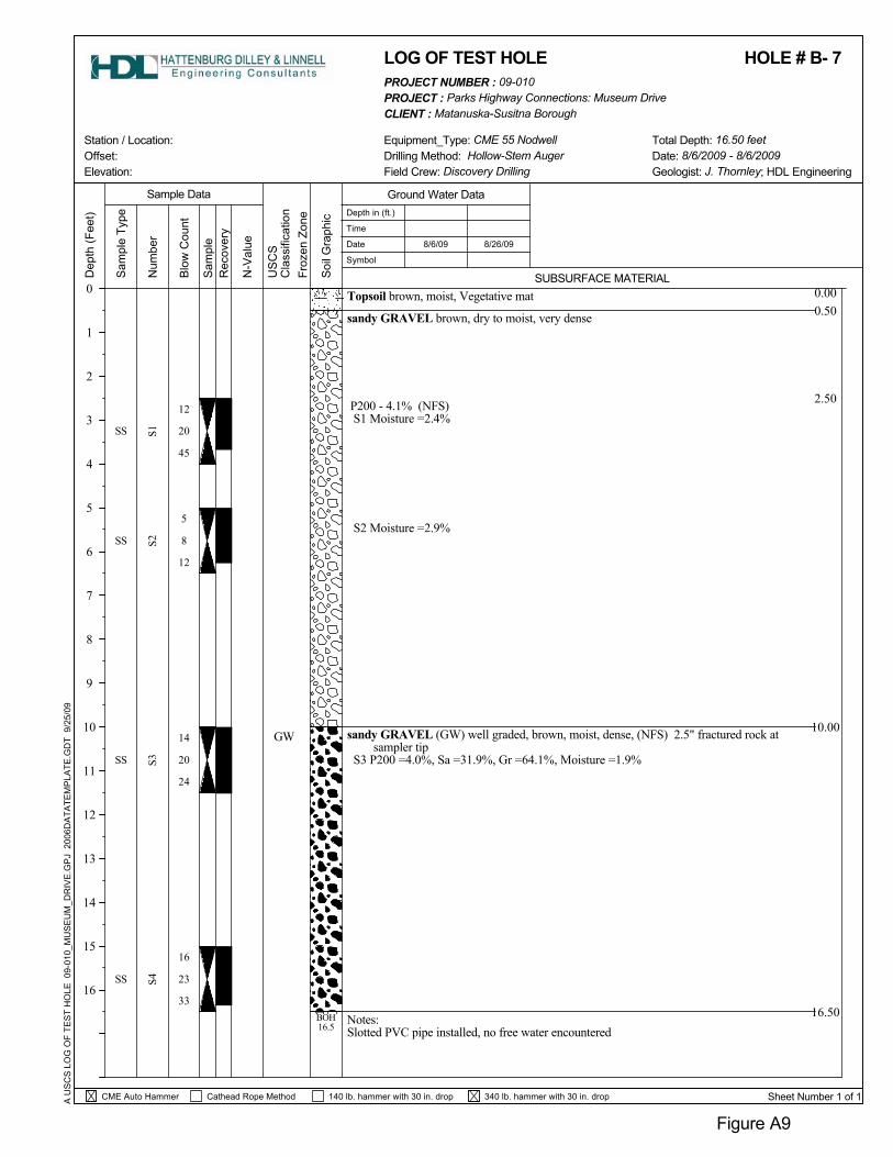
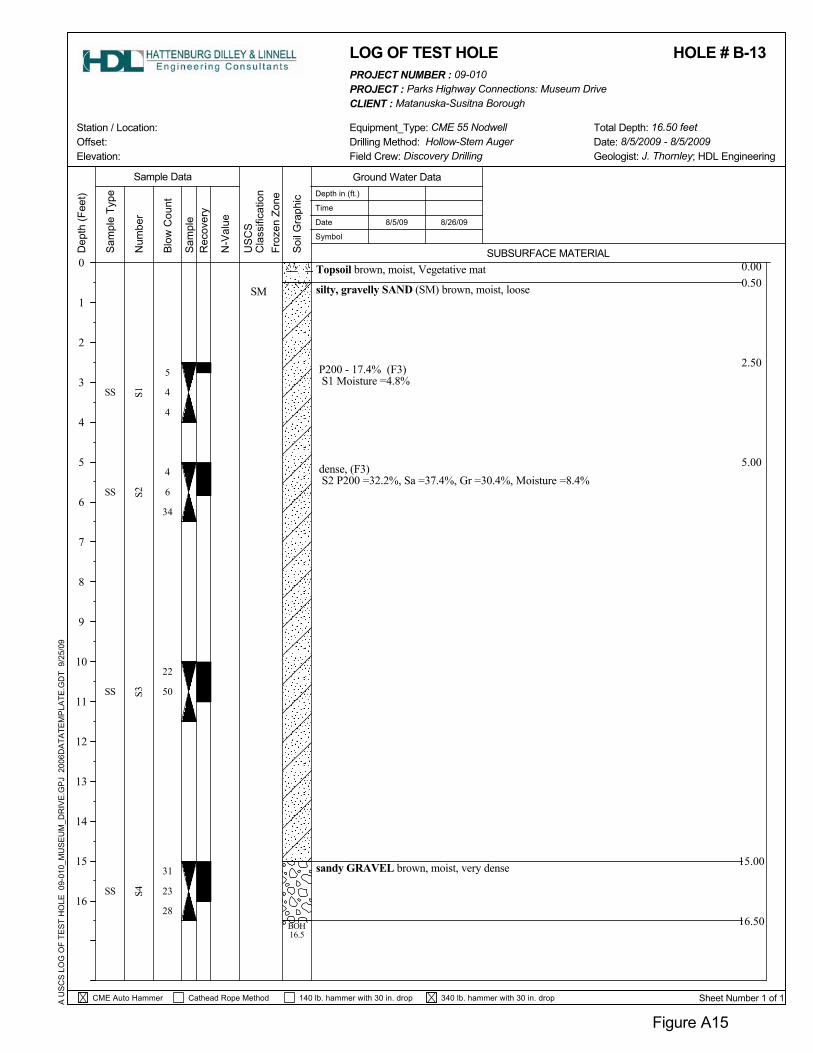
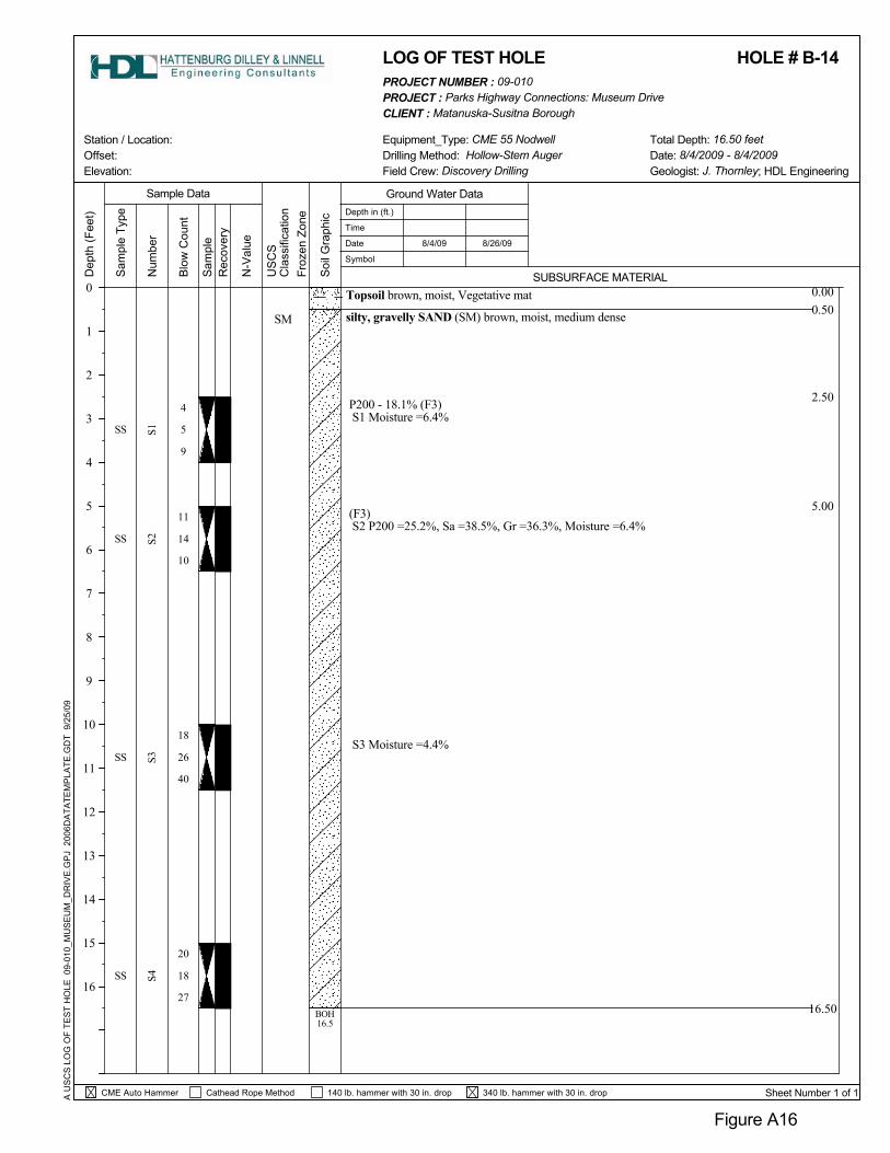
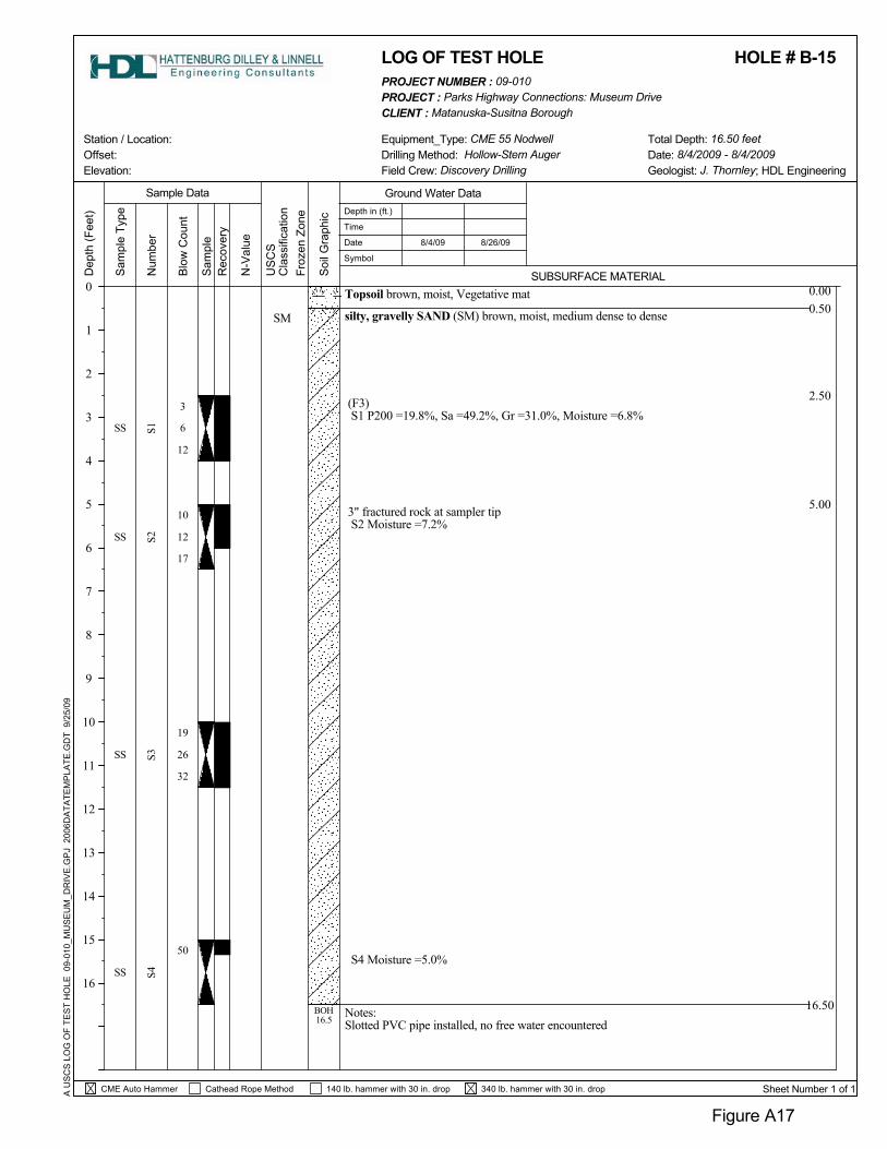
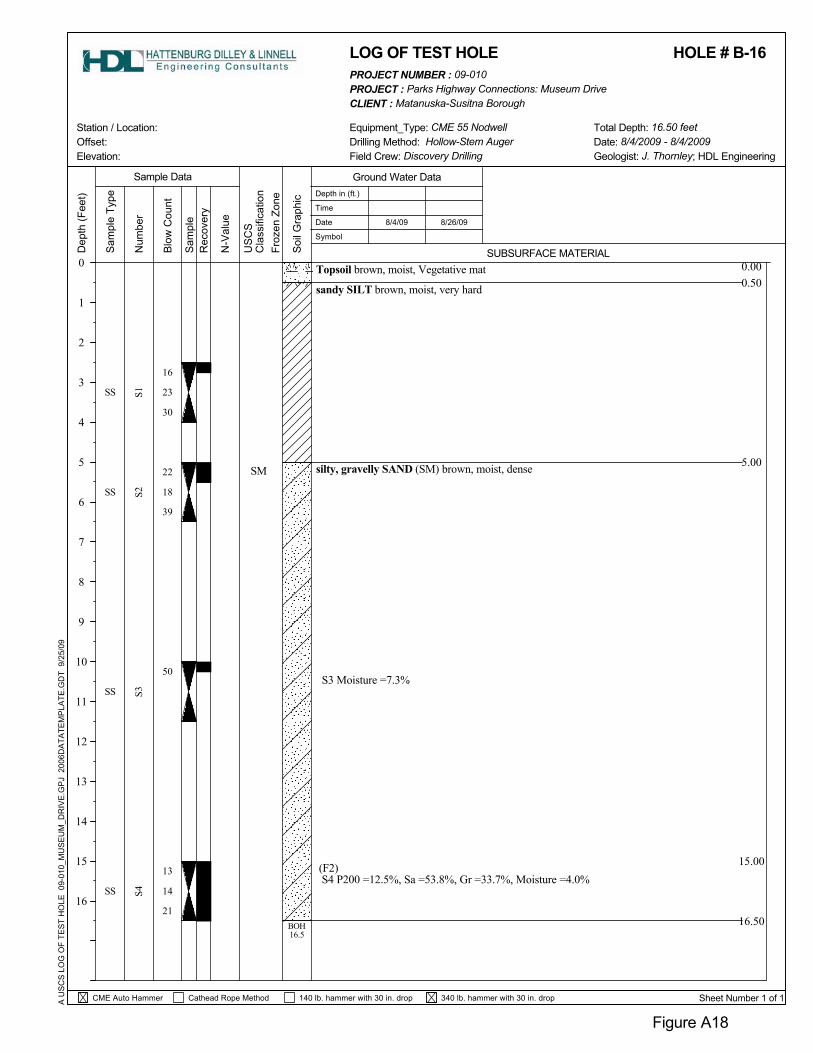
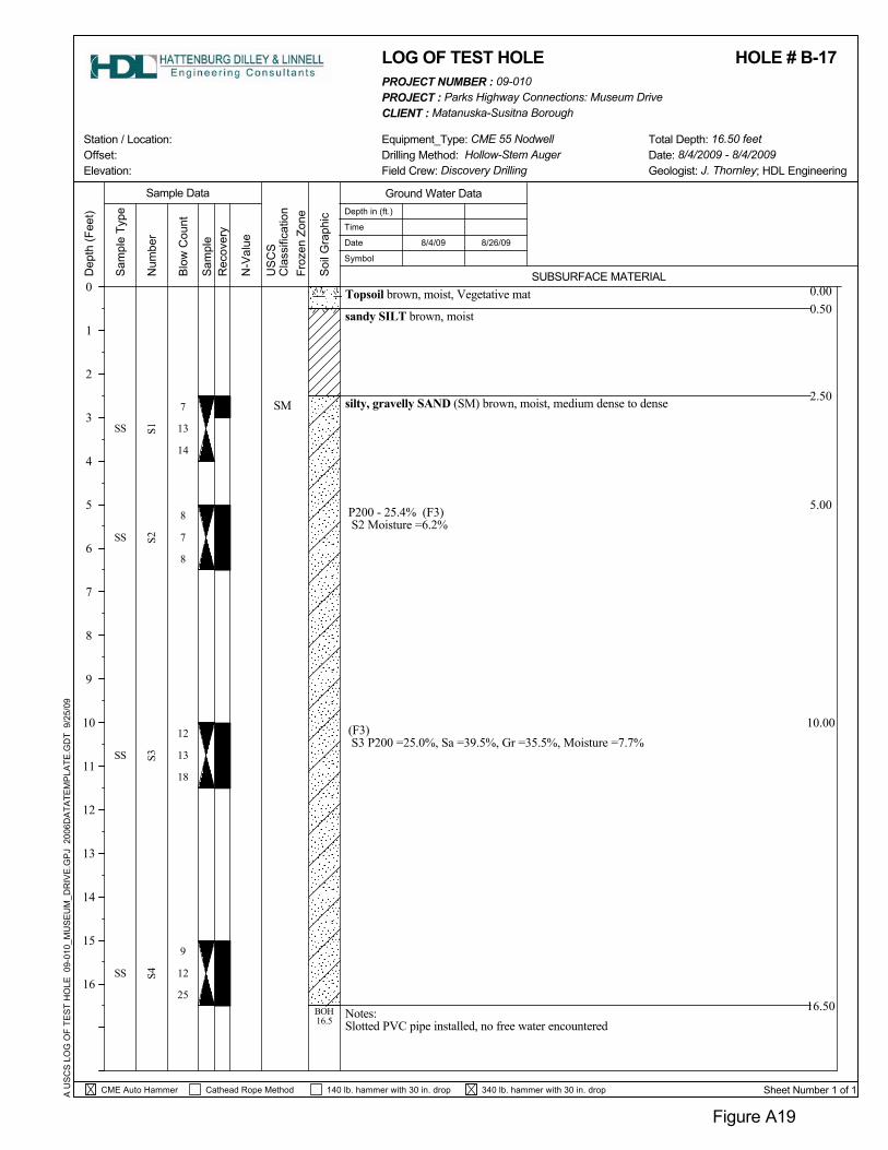
6.2.3 Borings B-13 Through B-20 (Station 71+50 to 104+00) Along the alignment, after Boring B-12, there is a significant rise in the ground surface topography, east of the small stream. Boring B-13 was advanced at the top edge of that slope. The soils encountered from Boring B-13 through B-20 (Figures 7 through 10 and A15 through A22) were found to be similar. These borings encountered a 6-inch thick vegetative mat of organics and tree roots. The soils consisted primarily of silty, gravelly sand to silty, sandy gravel with fines contents ranging from 12.5 to 32.2 percent. These soils are considered to be moderately frost susceptible and are classified as F2 and F3 soils. Rock fragments at the tip of the split-spoon sampler indicate that cobbles greater than 3 inches were encountered within the soil matrix. Moisture contents of these soils range from 4.0 to 8.4 percent. The relative densities of these soils range from medium dense to very dense. A layer of sandy silt was encountered just below the vegetative mat in Borings B-16, B-17, and B-20 with thicknesses of 4.5 feet, 2 feet, and 2 feet, respectively. These fine grained soils ranged from loose near the surface to very hard with depth. The sandy silt, as discussed previously, is considered highly frost susceptible, or classified as an F4 soil. Groundwater was encountered in Boring B-20. A 1-inch slotted PVC pipe was installed in this boring and ground water levels were measured to be approximately 11.5 feet below the ground surface.
6.2.4 Peat Deposits (Station 104+00 to 109+00) Between Boring B-20 and Museum Drive, surface water and a significant peat deposit were observed. Peat probing was performed in order to develop a contour map of the approximate peat thickness and is presented in Figure 11. Peat thickness in this area ranges from less than 10 inches to greater than 90 inches within the proposed roadway alignment right-of-way. There is an open body of water located to the south of this alignment. No other peat deposits were observed along the Museum Drive Extension Project alignment.


APPENDIX A
Figure A1 Unified Soil Classification Figure A2 Frost Classification Figure A3-A22 Boring Logs Figure A23-A26 Grain Size Curves


340 lb. hammer with 30 in. drop
Topsoil brown, moist, Vegetative mat
sandy GRAVEL (GP) poorly graded, grayish brown, dry to moist, dense
2.5" rock at sampler tipP200 - 3.9% (NFS)S1 Moisture =2.0%
(NFS)S2 P200 =4.7%, Sa =38.9%, Gr =56.4%, Moisture =2.1%
0.000.50
2.50
5.00
GP
Sam
ple
Type
A U
SC
S L
OG
OF
TES
T H
OLE
09-
010_
MU
SE
UM
_DR
IVE
.GP
J 2
006D
ATA
TEM
PLA
TE.G
DT
9/2
5/09
Soi
l Gra
phic
N-V
alue
Rec
over
y
8/26/09
Num
ber
16.50
S1
13
17
15
8
20
13
13
Sam
ple
S2S3
S4
19
12
14
13
SS
SS
SS
SS
BOH16.5
12
SUBSURFACE MATERIAL
Equipment_Type: CME 55 Nodwell
US
CS
Cla
ssifi
catio
n
Figure A3
Froz
en Z
one
PROJECT : Parks Highway Connections: Museum Drive
8/3/09
Blo
w C
ount
Offset: Station / Location:
Depth in (ft.)
Time
Date
Symbol
0
1
2
3
4
5
6
7
8
9
10
11
12
13
14
15
16
Sample Data
LOG OF TEST HOLE
Sheet Number 1 of 1
Drilling Method: Hollow-Stem Auger
CLIENT : Matanuska-Susitna Borough
Geologist: J. Thornley; HDL EngineeringField Crew: Discovery Drilling
140 lb. hammer with 30 in. drop
Dep
th (F
eet)
Date: 8/3/2009 - 8/3/2009Total Depth: 16.50 feet
CME Auto Hammer Cathead Rope Method
Ground Water Data
HOLE # B- 1PROJECT NUMBER : 09-010
Elevation:
sandy GRAVEL grayish brown, dry to moist, denseS2 Moisture =2.9%
2" fractured rocks in samplerS3 Moisture =3.7%
Fractured rocks in sampler
Notes:Slotted PVC pipe installed, no free water encountered
0.000.50
2.50
5.00
10.00
sandy GRAVEL (GW) well graded, grayish brown, dry to moist, medium dense
Rec
over
y
N-V
alue
Soi
l Gra
phic
Sam
ple
Type
15.00
16.50
A U
SC
S L
OG
OF
TES
T H
OLE
09-
010_
MU
SE
UM
_DR
IVE
.GP
J 2
006D
ATA
TEM
PLA
TE.G
DT
9/2
5/09
GW
Topsoil brown, moist, Vegetative mat
US
CS
Cla
ssifi
catio
n
10
8
12
16
26
11
12
16
50
S1S2
2.5" fractured rock in sampler tip
(NFS)S1 P200 =2.5%, Sa =31.3%, Gr =66.2%, Moisture =2.2%
SS
S3
BOH16.5
S4
SS
SS
SS
17
19
Station / Location:
SUBSURFACE MATERIAL
Sample DataS
ampl
e
Froz
en Z
one
8/26/09
Equipment_Type: CME 55 NodwellOffset:
CLIENT : Matanuska-Susitna BoroughPROJECT : Parks Highway Connections: Museum Drive
Figure A4
8/3/09
Blo
w C
ount
LOG OF TEST HOLE
Depth in (ft.)
Time
Date
Symbol
0
1
2
3
4
5
6
7
8
9
10
11
12
13
14
15
16
140 lb. hammer with 30 in. drop
Field Crew: Discovery Drilling
Sheet Number 1 of 1
Geologist: J. Thornley; HDL EngineeringDate: 8/3/2009 - 8/3/2009
Dep
th (F
eet)
Total Depth: 16.50 feet
HOLE # B- 2
CME Auto Hammer Cathead Rope Method
Ground Water Data
Num
ber
340 lb. hammer with 30 in. drop
Drilling Method: Hollow-Stem Auger
PROJECT NUMBER : 09-010
Elevation:

Topsoil brown, moist, Vegetative mat
sandy GRAVEL (GP) poorly graded, grayish brown, dry to moist, medium dense
2" fractured rock in sampler tip
(NFS)S2 P200 =4.5%, Sa =35.1%, Gr =60.4%, Moisture =2.8%
S4 Moisture =6.7%
0.000.50
2.50
5.00
340 lb. hammer with 30 in. drop
GP
US
CS
Cla
ssifi
catio
n
A U
SC
S L
OG
OF
TES
T H
OLE
09-
010_
MU
SE
UM
_DR
IVE
.GP
J 2
006D
ATA
TEM
PLA
TE.G
DT
9/2
5/09
Sam
ple
Soi
l Gra
phic
N-V
alue
Rec
over
y
8/26/09
Num
ber
16.50
S1
9
12
16
11
14
21
16
S2S3
S4
15
19
14
16
SS
SS
SS
SS
BOH16.5
Sam
ple
Type
15
SUBSURFACE MATERIAL
Equipment_Type: CME 55 Nodwell
Figure A5
Froz
en Z
one
PROJECT : Parks Highway Connections: Museum Drive
8/3/09
Blo
w C
ount
Offset: Station / Location:
Depth in (ft.)
Time
Date
Symbol
0
1
2
3
4
5
6
7
8
9
10
11
12
13
14
15
16
Sample Data
LOG OF TEST HOLE
Sheet Number 1 of 1
CLIENT : Matanuska-Susitna Borough
Drilling Method: Hollow-Stem AugerGeologist: J. Thornley; HDL EngineeringField Crew: Discovery Drilling
140 lb. hammer with 30 in. drop
Dep
th (F
eet)
Date: 8/3/2009 - 8/3/2009Total Depth: 16.50 feet
CME Auto Hammer Cathead Rope Method
Ground Water Data
HOLE # B- 3PROJECT NUMBER : 09-010
Elevation:
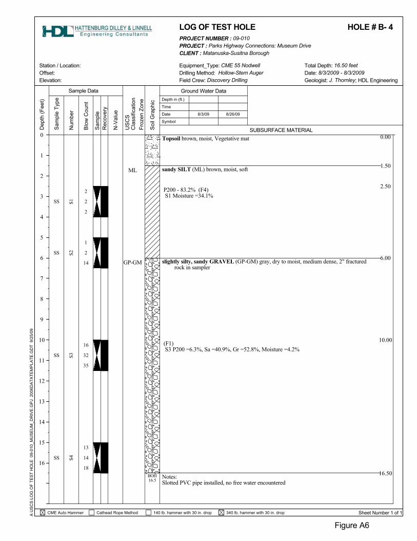
P200 - 83.2% (F4)S1 Moisture =34.1%
slightly silty, sandy GRAVEL (GP-GM) gray, dry to moist, medium dense, 2" fracturedrock in sampler
(F1)S3 P200 =6.3%, Sa =40.9%, Gr =52.8%, Moisture =4.2%
Notes:Slotted PVC pipe installed, no free water encountered
0.00
1.50
2.50
6.00
10.00
Topsoil brown, moist, Vegetative mat
GP-GM
Rec
over
y
N-V
alue
Sam
ple
Sam
ple
Type
16.50
A U
SC
S L
OG
OF
TES
T H
OLE
09-
010_
MU
SE
UM
_DR
IVE
.GP
J 2
006D
ATA
TEM
PLA
TE.G
DT
9/2
5/09
ML
US
CS
Cla
ssifi
catio
n
2
2
1
16
13
2
2
32
14
S1S2
sandy SILT (ML) brown, moist, soft
SS S3
SS S4
SS
SS
18
35
14
Soi
l Gra
phic
BOH16.5
8/26/09
Station / Location:
SUBSURFACE MATERIAL
Sample Data
Froz
en Z
one
Equipment_Type: CME 55 NodwellOffset:
CLIENT : Matanuska-Susitna BoroughPROJECT : Parks Highway Connections: Museum Drive
Figure A6
8/3/09
Blo
w C
ount
LOG OF TEST HOLE
Depth in (ft.)
Time
Date
Symbol
0
1
2
3
4
5
6
7
8
9
10
11
12
13
14
15
16
140 lb. hammer with 30 in. drop
Drilling Method: Hollow-Stem Auger Date: 8/3/2009 - 8/3/2009Geologist: J. Thornley; HDL Engineering
Sheet Number 1 of 1
Dep
th (F
eet)
340 lb. hammer with 30 in. drop
Num
ber
Field Crew: Discovery Drilling
Total Depth: 16.50 feet
CME Auto Hammer Cathead Rope Method
Ground Water Data
HOLE # B- 4PROJECT NUMBER : 09-010
Elevation:

sandy GRAVEL grayish brown, dry to moist, medium dense
2" fractured rock at sampler tipS1 Moisture =2.3%
sandy GRAVEL (GW) well graded, grayish brown, dry to moist, dense, (NFS) 2"fractured rock at sampler tip
S2 P200 =4.4%, Sa =38.1%, Gr =57.5%, Moisture =2.0%
2" fractured rock at sampler tipS3 Moisture =2.3%
Notes:Slotted PVC pipe installed, no free water encountered
0.000.50
2.50
5.00
16.50
GW
A U
SC
S L
OG
OF
TES
T H
OLE
09-
010_
MU
SE
UM
_DR
IVE
.GP
J 2
006D
ATA
TEM
PLA
TE.G
DT
9/2
5/09
US
CS
Cla
ssifi
catio
n
Sam
ple
Type
Sam
ple
N-V
alue
Rec
over
y
10.00
15
14
11
12
9
14
17
20
18
S1S2
Topsoil brown, moist, Vegetative mat
SS
Soi
l Gra
phic
S3
SS S4
SS
SS
24
23
24
BOH16.5
Station / Location:
SUBSURFACE MATERIAL
Sample Data
Froz
en Z
one
8/26/09
Equipment_Type: CME 55 NodwellOffset:
CLIENT : Matanuska-Susitna BoroughPROJECT : Parks Highway Connections: Museum Drive
Figure A7
8/3/09
Blo
w C
ount
LOG OF TEST HOLE
Depth in (ft.)
Time
Date
Symbol
0
1
2
3
4
5
6
7
8
9
10
11
12
13
14
15
16
140 lb. hammer with 30 in. drop
Drilling Method: Hollow-Stem Auger Date: 8/3/2009 - 8/3/2009Geologist: J. Thornley; HDL Engineering
Sheet Number 1 of 1
Total Depth: 16.50 feet
Dep
th (F
eet)
340 lb. hammer with 30 in. drop
Num
ber
Field Crew: Discovery Drilling
CME Auto Hammer Cathead Rope Method
Ground Water Data
HOLE # B- 5PROJECT NUMBER : 09-010
Elevation:

sandy GRAVEL grayish brown, dry to moist, very dense
2" fractured rock at sampler tip
S2 Moisture =2.4%
slightly silty, gravelly SAND (SP-SM) poorly graded, grayish brown, dry to moist, verydense
(F2)S4 P200 =6.7%, Sa =48.9%, Gr =44.4%, Moisture =3.7%
0.000.50
2.50
10.00
16.50
SP-SM
A U
SC
S L
OG
OF
TES
T H
OLE
09-
010_
MU
SE
UM
_DR
IVE
.GP
J 2
006D
ATA
TEM
PLA
TE.G
DT
9/2
5/09
US
CS
Cla
ssifi
catio
n
Sam
ple
Type
Sam
ple
N-V
alue
Rec
over
y
15.00
37
9
26
14
16
17
24
14
18
S1S2
Topsoil brown, moist, Vegetative mat
SS
Soi
l Gra
phic
S3
SS S4
SS
SS
15
25
20
BOH16.5
Station / Location:
SUBSURFACE MATERIAL
Sample Data
Froz
en Z
one
8/26/09
Equipment_Type: CME 55 NodwellOffset:
CLIENT : Matanuska-Susitna BoroughPROJECT : Parks Highway Connections: Museum Drive
Figure A8
8/3/09
Blo
w C
ount
LOG OF TEST HOLE
Depth in (ft.)
Time
Date
Symbol
0
1
2
3
4
5
6
7
8
9
10
11
12
13
14
15
16
140 lb. hammer with 30 in. drop
Drilling Method: Hollow-Stem Auger Date: 8/3/2009 - 8/3/2009Geologist: J. Thornley; HDL Engineering
Sheet Number 1 of 1
Total Depth: 16.50 feet
Dep
th (F
eet)
340 lb. hammer with 30 in. drop
Num
ber
Field Crew: Discovery Drilling
CME Auto Hammer Cathead Rope Method
Ground Water Data
HOLE # B- 6PROJECT NUMBER : 09-010
Elevation:
sandy GRAVEL brown, dry to moist, very dense
P200 - 4.1% (NFS)S1 Moisture =2.4%
S2 Moisture =2.9%
sandy GRAVEL (GW) well graded, brown, moist, dense, (NFS) 2.5" fractured rock atsampler tip
S3 P200 =4.0%, Sa =31.9%, Gr =64.1%, Moisture =1.9%
Notes:Slotted PVC pipe installed, no free water encountered
0.000.50
2.50
10.00
8/26/09
GW
A U
SC
S L
OG
OF
TES
T H
OLE
09-
010_
MU
SE
UM
_DR
IVE
.GP
J 2
006D
ATA
TEM
PLA
TE.G
DT
9/2
5/09
US
CS
Cla
ssifi
catio
n
Sam
ple
Type
Sam
ple
N-V
alue
Rec
over
y
16.50
45
12
5
14
16
20
8
20
23
S1S2
Topsoil brown, moist, Vegetative mat
SS
Soi
l Gra
phic
S3
SS S4
SS
SS
33
24
12
BOH16.5
LOG OF TEST HOLE
Station / Location: N
umbe
rEquipment_Type: CME 55 Nodwell
0
1
2
3
4
5
6
7
8
9
10
11
12
13
14
15
16
Froz
en Z
one
SUBSURFACE MATERIAL
Offset:
CLIENT : Matanuska-Susitna BoroughPROJECT : Parks Highway Connections: Museum Drive
Figure A9
8/6/09
Blo
w C
ount
Sample DataDepth in (ft.)
Time
Date
Symbol
Drilling Method: Hollow-Stem Auger Date: 8/6/2009 - 8/6/2009Geologist: J. Thornley; HDL EngineeringField Crew: Discovery Drilling
140 lb. hammer with 30 in. drop
Dep
th (F
eet)
340 lb. hammer with 30 in. drop Sheet Number 1 of 1
HOLE # B- 7
Total Depth: 16.50 feet
CME Auto Hammer Cathead Rope Method
Ground Water Data
PROJECT NUMBER : 09-010
Elevation:
340 lb. hammer with 30 in. drop
sandy SILT brown, moist
sandy GRAVEL brown, moist, denseS1 Moisture =2.9%
P200 - 6.5% (F1)S2 Moisture =2.8%
0.000.50
2.50
5.00
16.50
US
CS
Cla
ssifi
catio
n
A U
SC
S L
OG
OF
TES
T H
OLE
09-
010_
MU
SE
UM
_DR
IVE
.GP
J 2
006D
ATA
TEM
PLA
TE.G
DT
9/2
5/09
Sam
ple
Soi
l Gra
phic
N-V
alue
Rec
over
y
8/26/09
Num
ber
S1
8
18
14
16
15
50
Topsoil brown, moist, Vegetative mat
50
Sam
ple
Type
S2S3
S4
17
22
SS
SS
SS
SS
BOH16.5
21
Station / Location:
SUBSURFACE MATERIAL
Sample Data
Froz
en Z
one
Equipment_Type: CME 55 NodwellOffset:
CLIENT : Matanuska-Susitna BoroughPROJECT : Parks Highway Connections: Museum Drive
Figure A10
8/6/09
Blo
w C
ount
LOG OF TEST HOLE
Depth in (ft.)
Time
Date
Symbol
0
1
2
3
4
5
6
7
8
9
10
11
12
13
14
15
16
Geologist: J. Thornley; HDL EngineeringDrilling Method: Hollow-Stem Auger
140 lb. hammer with 30 in. drop
Date: 8/6/2009 - 8/6/2009
PROJECT NUMBER : 09-010
Elevation:
HOLE # B- 8
Sheet Number 1 of 1
Ground Water Data
Cathead Rope Method
Dep
th (F
eet)
Field Crew: Discovery Drilling
CME Auto Hammer
Total Depth: 16.50 feet

(NFS)S1 P200 =3.7%, Sa =38.4%, Gr =57.9%, Moisture =2.7%
P200 - 2.7% (NFS)S2 Moisture =2.5%
sandy GRAVEL (GP) poorly graded, brown, moist, denseS3 Moisture =2.9%
(NFS)S4 P200 =4.3%, Sa =38.8%, Gr =56.9%, Moisture =3.6%
Notes:Slotted PVC pipe installed, no free water encountered
0.000.50
2.50
5.00
10.00
Rec
over
y
GP
N-V
alue
Soi
l Gra
phic
Sam
ple
Type
15.00
16.50
A U
SC
S L
OG
OF
TES
T H
OLE
09-
010_
MU
SE
UM
_DR
IVE
.GP
J 2
006D
ATA
TEM
PLA
TE.G
DT
9/2
5/09
GW
US
CS
Cla
ssifi
catio
n
17
sandy GRAVEL (GW) well graded, brown, moist, dense
S2S1
17
17
S4
20
23
23
12
12
9
SS
S3
BOH16.5
Topsoil brown, moist, Vegetative mat
SS
SS
SS
15
21
6
Station / Location:
SUBSURFACE MATERIAL
Sample DataS
ampl
e
Froz
en Z
one
Equipment_Type: CME 55 NodwellOffset:
CLIENT : Matanuska-Susitna BoroughPROJECT : Parks Highway Connections: Museum Drive
Figure A11
8/6/09
Blo
w C
ount
LOG OF TEST HOLE
Depth in (ft.)
Time
Date
Symbol
0
1
2
3
4
5
6
7
8
9
10
11
12
13
14
15
16
140 lb. hammer with 30 in. drop
Field Crew: Discovery Drilling
Sheet Number 1 of 1
Dep
th (F
eet)
Geologist: J. Thornley; HDL EngineeringDate: 8/6/2009 - 8/6/2009Total Depth: 16.50 feet
CME Auto Hammer Cathead Rope Method
Ground Water Data
8/26/09
Num
ber
HOLE # B- 9
Drilling Method: Hollow-Stem Auger
340 lb. hammer with 30 in. drop
PROJECT NUMBER : 09-010
Elevation:

S2
N-V
alue
15
15
S3S1
22
22
15
15
17
S4
21
gravelly SAND (SP) poorly graded, brown, moist, dense
Sam
ple
Sam
ple
Type
BOH16.5
6
SS
SS
A U
SC
S L
OG
OF
TES
T H
OLE
09-
010_
MU
SE
UM
_DR
IVE
.GP
J 2
006D
ATA
TEM
PLA
TE.G
DT
9/2
5/09
SS
29
SS
US
CS
Cla
ssifi
catio
n
15.00
10.00
5.00
3.00
0.50
20
sandy SILT brown, moist
Notes:Slotted PVC pipe installed
P200 - 5.1% (NFS)S4 Moisture =3.8%
sandy GRAVEL brown, moist, very denseS3 Moisture =2.7%
(NFS)S2 P200 =2.4%, Sa =53.0%, Gr =44.6%, Moisture =2.9%
0.00
Soi
l Gra
phic
16.50
Topsoil brown, moist, Vegetative mat
SP
8
Equipment_Type: CME 55 Nodwell
LOG OF TEST HOLE
Station / Location:
Froz
en Z
one
SUBSURFACE MATERIALRec
over
y
CLIENT : Matanuska-Susitna BoroughPROJECT : Parks Highway Connections: Museum Drive
Figure A12
8/5/09
Blo
w C
ount
Sample Data
0
1
2
3
4
5
6
7
8
9
10
11
12
13
14
15
16
Offset:
Depth in (ft.)
Time
Date
Symbol
Drilling Method: Hollow-Stem Auger Date: 8/5/2009 - 8/5/2009Geologist: J. Thornley; HDL Engineering
Sheet Number 1 of 1
Field Crew: Discovery Drilling
140 lb. hammer with 30 in. drop
Elevation:
Dep
th (F
eet)
340 lb. hammer with 30 in. drop
Num
ber
8/26/09
Total Depth: 16.50 feet
CME Auto Hammer Cathead Rope Method
Ground Water Data
HOLE # B-10PROJECT NUMBER : 09-010
16.05

slightly silty, gravelly SAND (SP-SM) brown, moist, very dense
P200 - 4.9% (NFS)S1 Moisture =3.3%
(NFS)S2 P200 =5.3%, Sa =56.1%, Gr =38.6%, Moisture =2.5%
sandy GRAVEL brown, moist to wet, denseS3 Moisture =3.2%
0.000.50
2.50
5.00
10.00
Num
ber
SP-SM
A U
SC
S L
OG
OF
TES
T H
OLE
09-
010_
MU
SE
UM
_DR
IVE
.GP
J 2
006D
ATA
TEM
PLA
TE.G
DT
9/2
5/09
Sam
ple
Type
Sam
ple
Soi
l Gra
phic
N-V
alue
Rec
over
y
8/26/09
16.50
S3
9
20
15
26
19
18
Topsoil brown, moist, Vegetative mat
SS
US
CS
Cla
ssifi
catio
n
BOH16.5
S1
SS
S2
SS
29
19
50
S4SS
Equipment_Type: CME 55 Nodwell
Froz
en Z
one
LOG OF TEST HOLE
12
Station / Location:
Sample Data
SUBSURFACE MATERIAL0
1
2
3
4
5
6
7
8
9
10
11
12
13
14
15
16
340 lb. hammer with 30 in. drop
CLIENT : Matanuska-Susitna BoroughPROJECT : Parks Highway Connections: Museum Drive
Figure A13
8/5/09
Blo
w C
ount
Offset:
Depth in (ft.)
Time
Date
Symbol
Drilling Method: Hollow-Stem Auger
PROJECT NUMBER : 09-010
Elevation: Date: 8/5/2009 - 8/5/2009Geologist: J. Thornley; HDL Engineering
Sheet Number 1 of 1
Field Crew: Discovery Drilling
140 lb. hammer with 30 in. drop
Dep
th (F
eet)
Total Depth: 16.50 feet
HOLE # B-11
CME Auto Hammer Cathead Rope Method
Ground Water Data
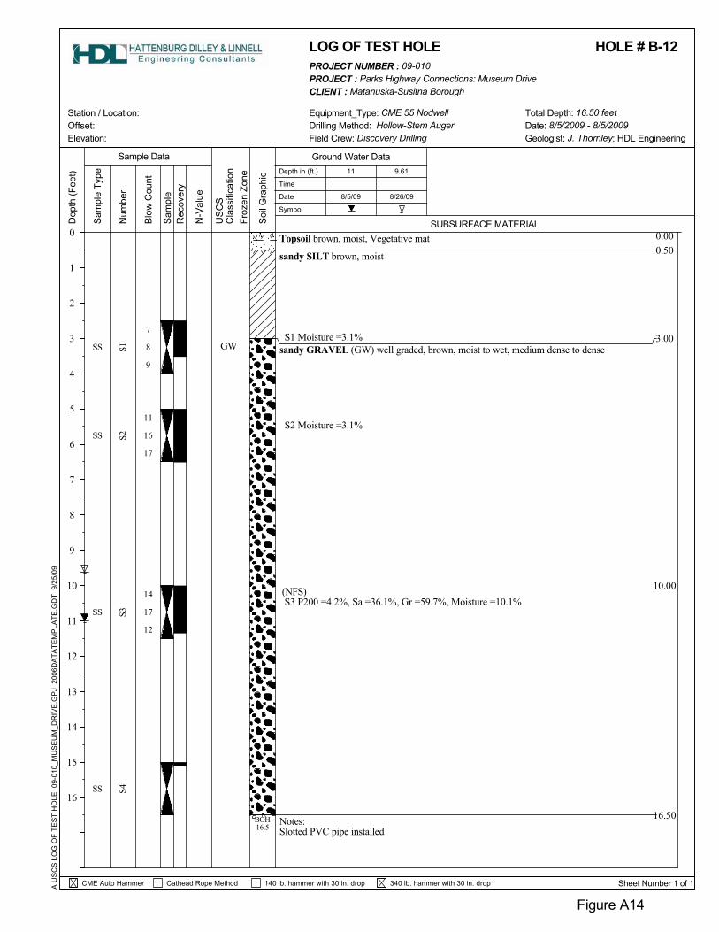
sandy SILT brown, moist
S1 Moisture =3.1%sandy GRAVEL (GW) well graded, brown, moist to wet, medium dense to dense
S2 Moisture =3.1%
(NFS)S3 P200 =4.2%, Sa =36.1%, Gr =59.7%, Moisture =10.1%
Notes:Slotted PVC pipe installed
0.000.50
3.00
10.00
Num
ber
Sam
ple 8/26/09
Rec
over
y
N-V
alue
Soi
l Gra
phic
16.50
Sam
ple
Type
A U
SC
S L
OG
OF
TES
T H
OLE
09-
010_
MU
SE
UM
_DR
IVE
.GP
J 2
006D
ATA
TEM
PLA
TE.G
DT
9/2
5/09
GW
Topsoil brown, moist, Vegetative mat
17
16
8
14
S2
7
S3
11
SS
US
CS
Cla
ssifi
catio
n
BOH16.5
S1
SS
SS
SS
12
17
9
S4Equipment_Type: CME 55 Nodwell
LOG OF TEST HOLE
11
Station / Location:
Froz
en Z
one
SUBSURFACE MATERIAL
340 lb. hammer with 30 in. drop
CLIENT : Matanuska-Susitna BoroughPROJECT : Parks Highway Connections: Museum Drive
Figure A14
8/5/09
Blo
w C
ount
Sample Data
0
1
2
3
4
5
6
7
8
9
10
11
12
13
14
15
16
Offset:
Depth in (ft.)
Time
Date
Symbol
Drilling Method: Hollow-Stem Auger
9.61
Elevation: Date: 8/5/2009 - 8/5/2009Geologist: J. Thornley; HDL Engineering
Sheet Number 1 of 1
Field Crew: Discovery Drilling
140 lb. hammer with 30 in. drop
Dep
th (F
eet)
Total Depth: 16.50 feet
HOLE # B-12
CME Auto Hammer
PROJECT NUMBER : 09-010
Cathead Rope Method
Ground Water Data
8/26/09
sandy GRAVEL brown, moist, very dense
0.000.50
2.50
5.00
15.00
16.50
P200 - 17.4% (F3)S1 Moisture =4.8%
silty, gravelly SAND (SM) brown, moist, looseSM
A U
SC
S L
OG
OF
TES
T H
OLE
09-
010_
MU
SE
UM
_DR
IVE
.GP
J 2
006D
ATA
TEM
PLA
TE.G
DT
9/2
5/09
US
CS
Cla
ssifi
catio
n
Sam
ple
Type
Sam
ple
Soi
l Gra
phic
Rec
over
y
4
5
4
22
31
4
6
50
23
S1S2
dense, (F3)S2 P200 =32.2%, Sa =37.4%, Gr =30.4%, Moisture =8.4%
S4
N-V
alue
34
28
SS
SS
SS
SS
BOH16.5
Topsoil brown, moist, Vegetative mat
S3Equipment_Type: CME 55 Nodwell
Froz
en Z
one
LOG OF TEST HOLE
Station / Location:
Sample Data
SUBSURFACE MATERIAL0
1
2
3
4
5
6
7
8
9
10
11
12
13
14
15
16
Num
ber
CLIENT : Matanuska-Susitna BoroughPROJECT : Parks Highway Connections: Museum Drive
Figure A15
8/5/09
Offset:
Depth in (ft.)
Time
Date
Symbol
Blo
w C
ount
Field Crew: Discovery DrillingDrilling Method: Hollow-Stem Auger Date: 8/5/2009 - 8/5/2009
Sheet Number 1 of 1140 lb. hammer with 30 in. drop
Dep
th (F
eet)
340 lb. hammer with 30 in. drop
Geologist: J. Thornley; HDL Engineering
HOLE # B-13
Total Depth: 16.50 feet
CME Auto Hammer Cathead Rope Method
Ground Water Data
PROJECT NUMBER : 09-010
Elevation:
Topsoil brown, moist, Vegetative mat
silty, gravelly SAND (SM) brown, moist, medium dense
P200 - 18.1% (F3)S1 Moisture =6.4%
(F3)S2 P200 =25.2%, Sa =38.5%, Gr =36.3%, Moisture =6.4%
S3 Moisture =4.4%
0.000.50
2.50
5.00
340 lb. hammer with 30 in. drop
SM
US
CS
Cla
ssifi
catio
n
A U
SC
S L
OG
OF
TES
T H
OLE
09-
010_
MU
SE
UM
_DR
IVE
.GP
J 2
006D
ATA
TEM
PLA
TE.G
DT
9/2
5/09
Sam
ple
Soi
l Gra
phic
N-V
alue
Rec
over
y
8/26/09
Num
ber
16.50
S2
4
11
18
20
5
14
26
S1S3
S4
9
10
40
27
SS
SS
SS
SS
BOH16.5
Sam
ple
Type
18
LOG OF TEST HOLE
Station / Location:
Froz
en Z
one
Equipment_Type: CME 55 Nodwell
0
1
2
3
4
5
6
7
8
9
10
11
12
13
14
15
16
SUBSURFACE MATERIAL
Offset:
CLIENT : Matanuska-Susitna BoroughPROJECT : Parks Highway Connections: Museum Drive
Figure A16
8/4/09
Blo
w C
ount
Sample DataDepth in (ft.)
Time
Date
Symbol
Elevation:
140 lb. hammer with 30 in. drop
Field Crew: Discovery Drilling
Sheet Number 1 of 1
Geologist: J. Thornley; HDL EngineeringDate: 8/4/2009 - 8/4/2009Drilling Method: Hollow-Stem Auger
PROJECT NUMBER : 09-010
Cathead Rope Method
HOLE # B-14
Ground Water Data
Dep
th (F
eet)
Total Depth: 16.50 feet
CME Auto Hammer
340 lb. hammer with 30 in. drop
silty, gravelly SAND (SM) brown, moist, medium dense to dense
(F3)S1 P200 =19.8%, Sa =49.2%, Gr =31.0%, Moisture =6.8%
3" fractured rock at sampler tipS2 Moisture =7.2%
S4 Moisture =5.0%
Notes:Slotted PVC pipe installed, no free water encountered
0.000.50
2.50
5.00
SM
Sam
ple
Type
A U
SC
S L
OG
OF
TES
T H
OLE
09-
010_
MU
SE
UM
_DR
IVE
.GP
J 2
006D
ATA
TEM
PLA
TE.G
DT
9/2
5/09
Soi
l Gra
phic
N-V
alue
Rec
over
y
8/26/09
Num
ber
16.50
S2
3
10
19
50
6
12
Topsoil brown, moist, Vegetative mat
S1
Sam
ple
S3S4
12
17
32
SS
SS
SS
SS
BOH16.5
26
LOG OF TEST HOLE
Froz
en Z
one
PROJECT : Parks Highway Connections: Museum Drive
Figure A17
US
CS
Cla
ssifi
catio
n
Equipment_Type: CME 55 Nodwell
SUBSURFACE MATERIAL
Station / Location:
8/4/09
Blo
w C
ount
Offset:
Depth in (ft.)
Time
Date
Symbol
0
1
2
3
4
5
6
7
8
9
10
11
12
13
14
15
16
Sample Data
Sheet Number 1 of 1
Drilling Method: Hollow-Stem Auger
CLIENT : Matanuska-Susitna Borough
Geologist: J. Thornley; HDL EngineeringField Crew: Discovery Drilling
140 lb. hammer with 30 in. drop
Dep
th (F
eet)
Date: 8/4/2009 - 8/4/2009Total Depth: 16.50 feet
CME Auto Hammer Cathead Rope Method
Ground Water Data
HOLE # B-15PROJECT NUMBER : 09-010
Elevation:
Num
ber
sandy SILT brown, moist, very hard
silty, gravelly SAND (SM) brown, moist, dense
S3 Moisture =7.3%
(F2)S4 P200 =12.5%, Sa =53.8%, Gr =33.7%, Moisture =4.0%
0.000.50
5.00
15.00
SM
A U
SC
S L
OG
OF
TES
T H
OLE
09-
010_
MU
SE
UM
_DR
IVE
.GP
J 2
006D
ATA
TEM
PLA
TE.G
DT
9/2
5/09
Sam
ple
Type
Sam
ple
Soi
l Gra
phic
N-V
alue
Rec
over
y
8/26/09
16.50
S1
16
22
50
13
23
Topsoil brown, moist, Vegetative mat
14
US
CS
Cla
ssifi
catio
n
S2S3
S4
30
39
21
SS
SS
SS
SS
BOH16.5
18
8/4/09
Figure A18
340 lb. hammer with 30 in. drop
Equipment_Type: CME 55 Nodwell
SUBSURFACE MATERIAL
Total Depth: 16.50 feet
Depth in (ft.)
Time
Date
Symbol
Blo
w C
ount
Offset: Station / Location:
0
1
2
3
4
5
6
7
8
9
10
11
12
13
14
15
16
Sample Data
LOG OF TEST HOLE
Field Crew: Discovery Drilling
Froz
en Z
one
Drilling Method: Hollow-Stem Auger Date: 8/4/2009 - 8/4/2009
CLIENT : Matanuska-Susitna Borough
Sheet Number 1 of 1140 lb. hammer with 30 in. drop
Dep
th (F
eet)
Geologist: J. Thornley; HDL Engineering
PROJECT NUMBER : 09-010
Cathead Rope Method
Ground Water Data
HOLE # B-16
CME Auto Hammer
Elevation:
PROJECT : Parks Highway Connections: Museum Drive
sandy SILT brown, moist
silty, gravelly SAND (SM) brown, moist, medium dense to dense
P200 - 25.4% (F3)S2 Moisture =6.2%
(F3)S3 P200 =25.0%, Sa =39.5%, Gr =35.5%, Moisture =7.7%
Notes:Slotted PVC pipe installed, no free water encountered
0.000.50
2.50
5.00
16.50
SM
A U
SC
S L
OG
OF
TES
T H
OLE
09-
010_
MU
SE
UM
_DR
IVE
.GP
J 2
006D
ATA
TEM
PLA
TE.G
DT
9/2
5/09
US
CS
Cla
ssifi
catio
n
Sam
ple
Type
Sam
ple
N-V
alue
Rec
over
y
10.00
14
7
8
12
9
13
7
13
12
S1S2
Topsoil brown, moist, Vegetative mat
SS
Soi
l Gra
phic
S3
SS S4
SS
SS
25
18
8
BOH16.5
Station / Location:
SUBSURFACE MATERIAL
Sample Data
Froz
en Z
one
8/26/09
Equipment_Type: CME 55 NodwellOffset:
CLIENT : Matanuska-Susitna BoroughPROJECT : Parks Highway Connections: Museum Drive
Figure A19
8/4/09
Blo
w C
ount
LOG OF TEST HOLE
Depth in (ft.)
Time
Date
Symbol
0
1
2
3
4
5
6
7
8
9
10
11
12
13
14
15
16
140 lb. hammer with 30 in. drop
Drilling Method: Hollow-Stem Auger Date: 8/4/2009 - 8/4/2009Geologist: J. Thornley; HDL Engineering
Sheet Number 1 of 1
Total Depth: 16.50 feet
Dep
th (F
eet)
340 lb. hammer with 30 in. drop
Num
ber
Field Crew: Discovery Drilling
CME Auto Hammer Cathead Rope Method
Ground Water Data
HOLE # B-17PROJECT NUMBER : 09-010
Elevation:

340 lb. hammer with 30 in. drop
Topsoil brown, moist, Vegetative mat
silty, gravelly SAND (SM) brown, dry to moist, medium dense to dense
S1 No sample recovered
(F3) 2.5" fractured rock at sampler tipS2 P200 =27.5%, Sa =42.1%, Gr =30.3%, Moisture =4.4%
S3 Moisture =6.5%
S4 Moisture =5.9%
0.000.50
5.00
SM
Sam
ple
Type
A U
SC
S L
OG
OF
TES
T H
OLE
09-
010_
MU
SE
UM
_DR
IVE
.GP
J 2
006D
ATA
TEM
PLA
TE.G
DT
9/2
5/09
Soi
l Gra
phic
N-V
alue
Rec
over
y
8/26/09
Num
ber
16.50
S1
4
12
14
21
10
12
36
Sam
ple
S2S3
S4
18
25
39
40
SS
SS
SS
SS
BOH16.5
30
LOG OF TEST HOLE
Station / Location:
Froz
en Z
one
Equipment_Type: CME 55 Nodwell
0
1
2
3
4
5
6
7
8
9
10
11
12
13
14
15
16
US
CS
Cla
ssifi
catio
nSUBSURFACE MATERIAL
Offset:
CLIENT : Matanuska-Susitna BoroughPROJECT : Parks Highway Connections: Museum Drive
Figure A20
8/4/09
Blo
w C
ount
Sample DataDepth in (ft.)
Time
Date
Symbol
Dep
th (F
eet)
140 lb. hammer with 30 in. drop
Field Crew: Discovery Drilling
Sheet Number 1 of 1
Geologist: J. Thornley; HDL EngineeringDate: 8/4/2009 - 8/4/2009Drilling Method: Hollow-Stem Auger
HOLE # B-18
Elevation:
CME Auto Hammer Cathead Rope Method
Ground Water Data
Total Depth: 16.50 feet
PROJECT NUMBER : 09-010

Num
ber
Topsoil brown, moist, Vegetative mat
silty, sandy GRAVEL (GM) brown, moist, medium dense, (F2)
S1 Moisture =7.1%
S2 P200 =17.2%, Sa =39.3%, Gr =43.5%, Moisture =5.0%
silty, gravelly SAND brown, moist, medium dense
0.000.50
7.00
GM
A U
SC
S L
OG
OF
TES
T H
OLE
09-
010_
MU
SE
UM
_DR
IVE
.GP
J 2
006D
ATA
TEM
PLA
TE.G
DT
9/2
5/09
Sam
ple
Type
Sam
ple
Soi
l Gra
phic
N-V
alue
Rec
over
y
8/26/09
16.50
50
6
10
12
18
6
23
US
CS
Cla
ssifi
catio
n
S1S2
S3S4
7
12
36
SS
SS
SS
SS
BOH16.5
16
LOG OF TEST HOLE
Station / Location: Equipment_Type: CME 55 Nodwell
0
1
2
3
4
5
6
7
8
9
10
11
12
13
14
15
16
340 lb. hammer with 30 in. drop
Froz
en Z
one
SUBSURFACE MATERIAL
Offset:
CLIENT : Matanuska-Susitna BoroughPROJECT : Parks Highway Connections: Museum Drive
Figure A21
8/4/09
Blo
w C
ount
Sample DataDepth in (ft.)
Time
Date
Symbol
140 lb. hammer with 30 in. drop
Field Crew: Discovery Drilling
Sheet Number 1 of 1
Geologist: J. Thornley; HDL EngineeringDate: 8/4/2009 - 8/4/2009Drilling Method: Hollow-Stem Auger
Elevation:
Total Depth: 16.50 feet
HOLE # B-19PROJECT NUMBER : 09-010
CME Auto Hammer
Dep
th (F
eet)
Ground Water Data
Cathead Rope Method

Notes:Slotted PVC pipe installed
2.50
0.500.00
10.00
16.50
(F3)S3 P200 =23.8%, Sa =44.1%, Gr =32.1%, Moisture =5.9%
3" fractured rock at sampler tipS2 No sample recovered
silty, gravelly SAND (SM) light brown, dry to moist, medium dense,P200 - 24.8% (F3)1.5" fractured rock at sampler tipS1 Moisture =6.9%
sandy SILT light brown, dry to moist
Topsoil brown, moist, Vegetative mat
8/26/09
Sam
ple
Type
Rec
over
y
N-V
alue
Soi
l Gra
phic
5.00
Sam
ple
A U
SC
S L
OG
OF
TES
T H
OLE
09-
010_
MU
SE
UM
_DR
IVE
.GP
J 2
006D
ATA
TEM
PLA
TE.G
DT
9/2
5/09
SM
12
4
6
14
10
7
S1
10
24BOH16.5
SS
SS 27
SS
US
CS
Cla
ssifi
catio
n
50
14
7
S4S3
S2SS
Total Depth: 16.50 feet
16
Station / Location:
SUBSURFACE MATERIAL
Equipment_Type: CME 55 Nodwell
LOG OF TEST HOLE
Num
ber
Figure A22
8/4/09
Blo
w C
ount
Depth in (ft.)
Time
Date
Symbol
0
1
2
3
4
5
6
7
8
9
10
11
12
13
14
15
16
Sample Data
Offset: Elevation: Geologist: J. Thornley; HDL Engineering
Date: 8/4/2009 - 8/4/2009Drilling Method: Hollow-Stem AugerField Crew: Discovery Drilling
CLIENT : Matanuska-Susitna Borough
Froz
en Z
one
140 lb. hammer with 30 in. dropCME Auto Hammer
PROJECT : Parks Highway Connections: Museum Drive
Sheet Number 1 of 1
11.45
PROJECT NUMBER : 09-010
HOLE # B-20D
epth
(Fee
t)
340 lb. hammer with 30 in. drop
Ground Water Data
Cathead Rope Method
100
90
85
80
75
70
65
95
50
55
100 10 1 0.1 0.001
coarse
0.01
60
0
5
10
15
20
25
30
35
40
45
31.3
B- 2B- 3B- 4B- 5
%Gravel %Sand %Silt %Clay38.9
35.140.938.1
HYDROMETERU.S. SIEVE OPENING IN INCHES U.S. SIEVE NUMBERS
fine
16
LLDepth 5.0Depth 2.5Depth 5.0
B- 1
Depth 5.0
60.4
20 30
Depth 5.0Depth 2.5Depth 5.0
Depth 10.0Depth 5.0
Specimen Identification
Depth 10.0
COBBLES
32.12
0.731.590.970.291.39
1.5
56.4
43.59
GRAVEL
Alaska 09-010
Matanuska-Susitna Borough
Parks Highway Connections: Museum Drive
Cu
52.857.5
Classification
3/4 1/2
76.6243.64
Specimen Identification
medium
6
37.53
66.2
PI
2.171
0.3060.3790.3250.1670.325
60
2.108
SAND
3.155
Cc
GRAIN SIZE DISTRIBUTION
1403 2
coarseSILT OR CLAY
8
11.492
3
PL
D30
1
0.782
6
16.53514.17212.7610.426
5050505050
1.598
sandy GRAVEL (GP)
D10
4
fine
5010
sandy GRAVEL (GW)sandy GRAVEL (GP)
slightly silty, sandy, GRAVEL (GP-GM)sandy GRAVEL (GW)
4 20040
GR
AIN
SIZ
E 0
9-01
0_M
US
EU
M_D
RIV
E.G
PJ
HD
EC
.GD
T 9
/25/
09 1
4:47
D100 D60
3/8 100
B- 1B- 2B- 3
PE
RC
EN
T FI
NE
R B
Y W
EIG
HT
B- 5
GRAIN SIZE IN MILLIMETERS
4.72.54.56.34.4
14
B- 4
Figure A23

100
90
85
80
75
70
65
60
95
50
100 10 1 0.1 0.001
45
coarse
0.01
55
0
5
10
15
20
25
30
35
40
31.9
B- 7B- 9B- 9B-10
%Gravel %Sand %Silt %Clay48.9
38.438.853.0
HYDROMETERU.S. SIEVE OPENING IN INCHES U.S. SIEVE NUMBERS
fine
16
LLDepth 15.0Depth 10.0Depth 2.5
B- 6
Depth 5.0
57.9
20 30
Depth 15.0Depth 10.0Depth 2.5
Depth 15.0Depth 5.0
Specimen Identification
Depth 15.0
COBBLES
20.99
0.291.171.290.580.17
1.5
44.4
56.78
GRAVEL
Alaska 09-010
Matanuska-Susitna Borough
Parks Highway Connections: Museum Drive
200
56.944.6
Classification
3/4 1/2
20.3838.26
Specimen Identification
medium
6
42.95
64.1
PI
1.8110.577
0.1530.3390.27
0.5290.302
6010
SAND
0.543
Cc
GRAIN SIZE DISTRIBUTION
1403 2
coarseSILT OR CLAY
6.577
GR
AIN
SIZ
E 0
9-01
0_M
US
EU
M_D
RIV
E.G
PJ
HD
EC
.GD
T 9
/25/
09 1
4:47
3
PL
D30
1
1.898
6
2.76819.25310.32110.7776.335
5063.550
63.537.5
14
slightly silty, gravelly SAND (SP-SM)
D10
4
fine
508
sandy GRAVEL (GW)sandy GRAVEL (GW)sandy GRAVEL (GP)gravelly SAND (SP)
4
40
D100 D60
3/8 100
B- 6B- 7B- 9
PE
RC
EN
T FI
NE
R B
Y W
EIG
HT
B-10
GRAIN SIZE IN MILLIMETERS
6.74.03.74.32.4
Cu
B- 9
Figure A24

100 0.0010.010.110
50
1
60
65
70
75
80
85
90
95
100
coarse
45
55
0
5
10
15
20
25
30
35
40
%Clay
B-11B-12B-13B-14B-15
%Gravel
U.S. SIEVE OPENING IN INCHES
%Silt
Depth 2.5
56.136.137.438.549.2
%Sand
Depth 5.0
Cu
LLSpecimen Identification
Depth 10.0
Depth 5.0Depth 2.5
16 20 30
Depth 5.0Depth 10.0Depth 5.0Depth 5.0
U.S. SIEVE NUMBERS
Depth 5.0
GRAVEL
19.0931.58
0.571.50
1.5
HYDROMETER
COBBLES
Alaska 09-010
Matanuska-Susitna Borough
Parks Highway Connections: Museum Drive
fine
38.659.730.436.331.0
Classification
61/2
medium
Specimen Identification
3/4
PI
37.5
0.7392.158
0.1150.376
0.2250.314
608
SAND
37.5
Cc
GRAIN SIZE DISTRIBUTION
1403 2
coarse
200
3
PL
5050
16
4.2899.9021.3422.81
2.155
50
10
D30
GRAIN SIZE IN MILLIMETERS
PE
RC
EN
T FI
NE
R B
Y W
EIG
HT
D10
4
fineSILT OR CLAY
slightly silty, gravelly SAND (SP-SM)sandy GRAVEL (GW)
gravelly, silty SAND (SM)silty, gravelly SAND (SM)silty, gravelly SAND (SM)
4 50
B-14
14
D100 D60
3/8 100
B-11
B-13
B-15
40
5.34.232.225.219.8
GR
AIN
SIZ
E 0
9-01
0_M
US
EU
M_D
RIV
E.G
PJ
HD
EC
.GD
T 1
/20/
10 1
0:02
B-12
Figure A25

GRAVEL
Parks Highway Connections: Museum Drive
65
70
75
80
85
90
55
100
50
Matanuska-Susitna Borough
09-010Alaska
95
10
60
5
15
20
25
30
35
40
45
0
Depth 5.0
LLDepth 15.0
Depth 5.0
Cu
Depth 10.0
16 20 30
Depth 15.0Depth 10.0Depth 5.0
Depth 10.0
silty, sandy GRAVEL (GM)
50
silty, gravelly SAND (SM)
silty, gravelly SAND (SM)
silty, gravelly SAND (SM)
4 200
silty, gravelly SAND (SM)
Depth 5.0
COBBLES
37.5
0.4930.1240.0910.3830.139
5050
SAND
PI Cc
GRAIN SIZE DISTRIBUTION
1403 603
PL
D30
63.5
1
coarse
6
3.3873.0921.6966.8532.361
37.5
PE
RC
EN
T FI
NE
R B
Y W
EIG
HT
27.517.223.8
2
GRAIN SIZE IN MILLIMETERS
40
D10
4
Depth 10.0
Specimen Identification
3/8
SILT OR CLAY
810 14
25.0
D6012.5
100
B-16B-17B-18B-19B-20
D100
1/23/4
fine
Classification
GR
AIN
SIZ
E 0
9-01
0_M
US
EU
M_D
RIV
E.G
PJ
HD
EC
.GD
T 9
/25/
09 1
4:47
32.143.5
0.001
1.5
1.41 66.47
Specimen Identification33.7
0.010.1110100
6
medium
B-18B-17B-16
30.3
%Gravel
coarse
39.3
fine
U.S. SIEVE NUMBERSU.S. SIEVE OPENING IN INCHES HYDROMETER
B-1944.1B-20
42.139.553.8
%Clay%Silt%Sand
35.5
Figure A26