german project laserbathymetry 27 may 2014. 26.08.2015ellmer: german project2 content aim of the...
TRANSCRIPT

German Project Laserbathymetry27 May 2014

19.04.23 Ellmer: German Project 2
Content
• Aim of the project
• Questions to be answered
• Organization of the project
• Preliminary conclusions

Aim of the project
• Not to lose track of important actual developments
• How much money do I need for surveying the relevant areas
• Many questions in detail:
• Which areas are relevant for laserbathymetry?
• Where is laserbathymetry cheaper than shipborne measurements?
19.04.23 Ellmer: German Project 3
Questions to be answered
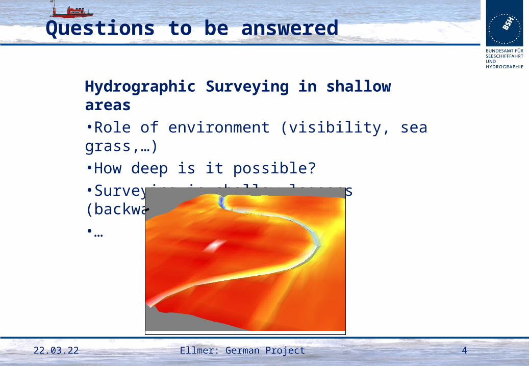
Hydrographic Surveying in shallow areas
•Role of environment (visibility, sea grass,…)
•How deep is it possible?
•Surveying in shallow lagoons (backwater)
•…
19.04.23 Ellmer: German Project 4

Questions to be answered
Wreck Search
•Objects of 2m size (IHO S-44)? Which size is certainly detectable
•Is detectable size depth dependent?
19.04.23 Ellmer: German Project 5
Questions to be answered
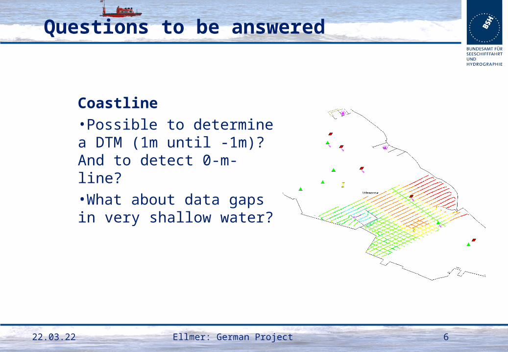
Coastline
•Possible to determine a DTM (1m until -1m)? And to detect 0-m-line?
•What about data gaps in very shallow water?
19.04.23 Ellmer: German Project 6
Questions to be answered
Call for tenders
•Possible flight parameters for all purposes (DTM, wreck search, coastline)?
•What has to be considered when writing a call
•How to calculate a price for budget planning?
19.04.23 Ellmer: German Project 7
§

Organization of the project
Overview
•3 years project 2012 - 2014
•Scientific Cooperation
• Leibnitz Universität Hannover
• 1 scientist
•3 flights autumn 2012, 2013, spring 2014
•Frequent meetings with different interested organizations
• HO and university
• Water and shipping administration (federal)
• Coastal protection (states)
• Navy (federal)
• Land survey (states)19.04.23 Ellmer: German Project 8

19.04.23 9Ellmer: German Project
Organization of the project
2012
•Request for high resolution
•Milan with Riegl VQ820G
•3 heights (500m, 700m, 300m)

10Ellmer: German Project19.04.23
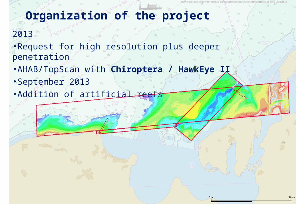
Organization of the project
2013
•Request for high resolution plus deeper penetration
•AHAB/TopScan with Chiroptera / HawkEye II
•September 2013
•Addition of artificial reefs
1119.04.23 Ellmer: German Project
Organization of the project
2013
•Request for high resolution plus deeper penetration
•AHAB/TopScan with Chiroptera / HawkEye II
•September 2013
•Addition of artificial reefs

12Ellmer: German Project19.04.23
Organization of the project
2014
•Request for high resolution plus deeper penetration
•AHAB/Aerodata with Hawkeye III
•Flight in April 2014 with Chiroptera
•Additional flight with Hawkeye III in autumn

13Ellmer: German Project19.04.23
Organization of the project
2013 + 2014
•Addition of artificial reefs

Organization of the project
Artificial reefs
•Good for checking the accuracy
•Located close to Rostock
•Accurately surveyed by multibeam
19.04.23 Ellmer: German Project 14
reefs
Riff Nienhagen

Preliminary conclusions
3 flights
•Much information
•Easier to collect data than to process all information
•Evaluation 2013 is not finished
•Processing 2014 just started
•Conclusions at this time very rough
19.04.23 Ellmer: German Project 15
Preliminary conclusions
Very preliminary
•Accuracy not the main problem
•Dependent on careful processing
• How to check the carefulness?
19.04.23 Ellmer: German Project 16

Preliminary conclusions
Data gaps
•Data very inhomogeneous
• From >5 points/m² to >5 m²/point
•Gaps even in shallow areas
• Still to develop: Which density is too low for S-44?
19.04.23 Ellmer: German Project 17

Preliminary conclusions
Wrecks, Obstructions
•At this time not reliable to detect
•Riff Rosenort data from Chiroptera 2013
19.04.23 Ellmer: German Project 18

Preliminary conclusions
19.04.23 Ellmer: German Project 19
Résumé:
•LIDAR is a very interesting development for shallow waters;
•Traditional methods have disadvantages in shallow areas:
• Single-beam data provide too large gaps in-between;
• Multi-beam surveys need too many survey lines;
•LIDAR does not provide an alternative but a complement;
•Combination of land and sea data becomes more important
•A wider scope of the use and users of the data is necessary:
• Not only safety at Sea (nautical charting)
• Not only coastal protection
This is in line with the Theme for World Hydrography Day 2014:
Hydrography – much more than nautical charting

19.04.23 Ellmer: German Project 20