getting started with the regional information map - hope · fraser valley regional district rim...
TRANSCRIPT

Getting Started
With The
Regional Information Map
Fraser Valley Regional District RIM User Guide
Page 2 of 16
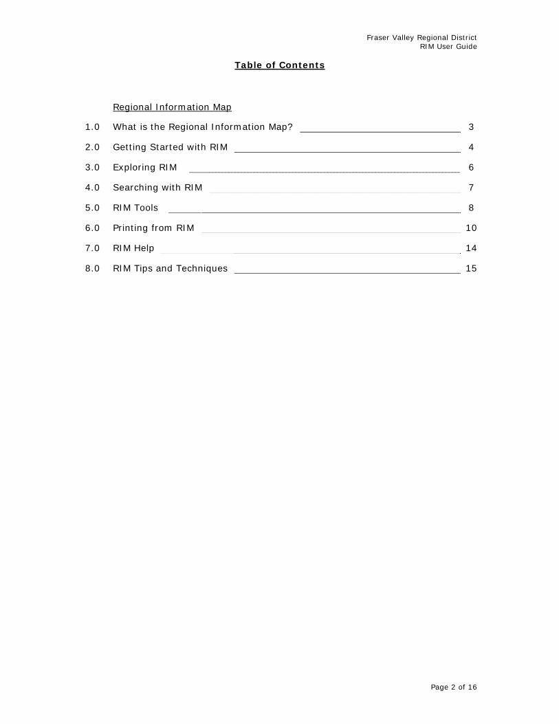
Table of Contents
Regional Information Map
1.0 What is the Regional Information Map? 3
2.0 Getting Started with RIM 4
3.0 Exploring RIM 6
4.0 Searching with RIM 7
5.0 RIM Tools 8
6.0 Printing from RIM 10
7.0 RIM Help 14
8.0 RIM Tips and Techniques 15

Fraser Valley Regional District RIM User Guide
Page 3 of 16
1.0 What is the Regional Information Map?
The Regional Information Map (RIM) is a web-based, interactive map that is available to the public through the FVRD website. RIM is free to use and was developed with the beginner in mind. RIM contains valuable information for those who live, visit, and work in the Regional District. Some of the available layers include property, zoning, and hazard information. Aerial photographs are also available for select areas. A number of helpful tools are available in RIM and can be used with several key layers. These tools make it possible to:
Find a feature – search for a property or geodetic monument Learn about a feature – identify feature attributes Analyze a feature – measure, select, or buffer features Create a property report – display key attributes for a selected property Create a map – with or without aerial photographs Mark up a map - add text and sketch graphics Zoom to coordinates – x & y positions in UTM
The information on RIM is the same data used for the Regional District’s day-to-day business processes. The Geographic Information Systems (GIS) Group works to ensure that the data is as accurate as possible. However, the information is provided for general use only. All information presented in the application should be confirmed with the GIS Group or the Planning Department. There are some known issues with RIM such as data inaccuracies and application bugs that the GIS Group is working to correct. These issues are minor and do not take away from the application. RIM can be accessed through the FVRD home web page or the Mapping Services section. Once open, the application is easy to navigate and the tools are user friendly. Application and operational help is available within RIM. The Regional District provides this service for the interest and convenience of the public. It will evolve and improve in time as more data becomes available and with feedback from users. Please contact the GIS Group with any comments that you may have or questions regarding RIM. In addition, several of the Regional District’s member municipalities also have web mapping applications. We recommend these sites to learn detailed information regarding features located within the municipalities. For more information on RIM or to provide feedback, please contact the GIS Group at [email protected].

Fraser Valley Regional District RIM User Guide
Page 4 of 16
2.0 Getting Started with RIM
RIM is accessed through the FVRD website, either through the FVRD home web page or the Mapping Services section. Terms of Use must be accepted prior to using RIM. Once the terms have been read and agreed to, RIM will open in a new browser window. The steps below describe how to open RIM.
Note: The Terms of Use page not only contains the terms, but also provides information on some of the uses, system requirements, and availability of RIM as well as contact information for the Regional District’s GIS Group.
1. Open the FVRD Home Web Page (www.fvrd.bc.ca). 2. Click the Regional Information Map button (see below).
3. Read the Regional Information Map page and select the Accept Terms button at the bottom to agree to the Terms of Use.
Note: If the Decline Terms button is selected, you will be returned to the Mapping Services page.
4. RIM should now be visible.
- Or -
1. Open the FVRD Home Web Page (www.fvrd.bc.ca). 2. Go to the Services Menu at the top of the page.
3. Select Mapping from the drop down menu. 4. Select Regional Information Map from the fly out menu. 5. Read the Regional Information Map page and select the Accept
Terms button at the bottom to agree to the Terms of Use. 6. RIM should now be visible.

Fraser Valley Regional District RIM User Guide
Page 5 of 16
FVRD Home Web Page (showing the RIM fly out menu)

Fraser Valley Regional District RIM User Guide
Page 6 of 16
3.0 Exploring RIM
RIM is made up of three parts: the Toolbar, the Console, and the Map. In the Toolbar, the user can access the zoom, scale, pan, and help tools among others. In the Console, the user can access the Tasks, Results, and Map Contents Menus. The Map contains the dynamic map control.
Regional Information Map (RIM)
Toolbar
Console
Map

Fraser Valley Regional District RIM User Guide
Page 7 of 16
4.0 Searching with RIM
Currently, RIM allows users to search for properties by civic address, folio number, PID, and plan number.
1. Open the Search Tools dialog from the Tasks Menu.
2. The Search Tools task has a number of pre-defined searches;
click the drop-down arrow to view and select an appropriate one (this example uses “Civic” for civic address).
3. In the query fields, type in the details of your search (i.e. the
house number and street name).
Note: Use “%” as a wildcard character where the entire search string is not known. Note: It is best to perform an initial address search without the unit number. The unit number can be used to refine the search should several addresses be returned.
4. Click the Search button in the Search Tools dialog to retrieve the
results. 5. The map will highlight and zoom to the selected property(s). The
selected record(s) will be under the Results Menu in the Console area of the application.
Searching with RIM
Results Menu
Search Task
Search Task Dialog
Fraser Valley Regional District RIM User Guide
Page 8 of 16
5.0 RIM Tools
RIM has many tools for both the casual and experienced user. Most tools can be activated at any time while others require that a property or feature be selected beforehand. Tools are enabled with tool-tips that describe their use. The on-line Help also provides information on how to use these tools. Some of the more commonly used tools are described below.
5.1 Export Map The Export Map task is found in the Tasks Menu. It allows users to export an image to save or email. This image only includes the map display and not any of the other components of RIM. The user can select the size and type of image.
5.2 Identify
The Identify task is found in the Tasks Menu. It provides users with the ability to interactively click on a map to retrieve information from attributes, related database tables, or hyperlinks from one or more layers at the clicked location. The user can specify how they want the results displayed (i.e. in the Results Menu or as an HTML page). This tool only works with specific layers.
5.3 Print to PDF
The Print to PDF task is found in the Tasks Menu. It allows users to print PDF maps. The user can personalize the map by adding a title and description as well as by choosing a scale, visible layers, and page size.
5.4 Markup The Markup task is found in the Tasks Menu. It allows users to sketch areas or make notes on a map by generating graphics. The feature type, style, and colour can be specified by the user.
5.5 Selection Tools
The Selection Tools task is found in the Tasks Menu. It allows users to select or buffer features. The tool also allows users to manage selected features (i.e. add, remove, or clear the selection set). This tool only works with specific layers.
5.6 Reports
The Reports task is found in the Tasks Menu. It allows users to print a PDF report for a single, selected property. Currently, there is only one report available to users, the Property Information report.
Fraser Valley Regional District RIM User Guide
Page 9 of 16
5.7 Zoom to XY
The Zoom to XY task is found in the Tasks Menu. It provides users with the ability to locate a place using coordinate values. The user must know the UTM coordinate values and enter them as x (easting) and y (northing) values.
5.8 Search Tools
The Search Tools task is found in the Tasks Menu. It allows users to search for properties by civic, folio, PID or plan number. Once found, the map will highlight and zoom to the selected feature(s). This tool only works with specific layers.
5.9 Other Tools
Several other useful tools can be found on the Toolbar. Among the various zoom functions, some tools to note are: Identify Tool – different from the Identify task. It allows users to retrieve
attribute information for all map layers. Measure Tool – it allows users to retrieve x & y coordinates or measure
distances and areas. The units of measurement can be specified.
Scale Textbox – users can enter a scale of their choice or choose one of the predefined scales.
Fraser Valley Regional District RIM User Guide
Page 10 of 16
6.0 Printing from RIM
Currently, there are two products that can be printed from RIM, a map and a report.
6.1 Printing a Map
1. To print a map, zoom or pan to an area of interest. This can be done by selecting a property with one of the selection tools or manually by using the pan and zoom tools.
Note: You can print one map that shows multiple properties. Selected properties will be highlighted when printed.
2. Ensure that the required map layers are visible on the map (i.e.
they are checked on in the Map Contents Menu of the Console). 3. Specify the scale of the map in the Scale textbox on the Toolbar if
the system-defined scale is not appropriate. 4. Once the area has been specified and the layers and scale have
been set, select the Print to PDF from the Tasks Menu in the Console.
5. When the Print to PDF dialog opens, specify the Title of the map,
the Description, the Page Size, and the Map Resolution, as well as whether to show the Overview Map. Select Print.
Note: Currently, users only have the option to select Letter (8 ½” x 11”) or Tabloid (11” x 17”) page sizes.
6. After the map is printed, a PDF will be available for download under
the Results Menu of the Console. Select Download Map to open the PDF.

Fraser Valley Regional District RIM User Guide
Page 11 of 16
7. A new browser window will open with the completed map. Save or
print the map from this browser as you would with any other PDF.
Note: If you require the map to be a specific scale, turn off Page Scaling (under your browser’s Print menu).
PDF Map from RIM
Download Map
Print Task
Print Task Dialog

Fraser Valley Regional District RIM User Guide
Page 12 of 16
6.2 Printing a Report
1. To print the Property Information report from RIM, a property of interest must be selected first. This can be done with the Search Tools or Selection Tools in the Tasks Menu.
Note: The Property Information report can only be used for a single property.
2. Once a property has been selected, choose Reports from the
Tasks Menu in the Console. 3. When the Reports dialog is visible, set the Select Report field to
“Property Information”. Set the Report Format to “PDF”. Click Get Report.
4. After the report is generated, a PDF will be available for download
under the Results Menu of the Console. Select Download Report to open the PDF.
5. A new browser window will open with the generated report. Save
or print the report from this browser as you would with any other PDF.
Note: If you require the map to be a specific scale, turn off Page Scaling (under your browser’s Print menu).
Download Report
Report Task
Report Task Dialog

Fraser Valley Regional District RIM User Guide
Page 13 of 16
PDF Property Information Report from RIM
Fraser Valley Regional District RIM User Guide
Page 14 of 16
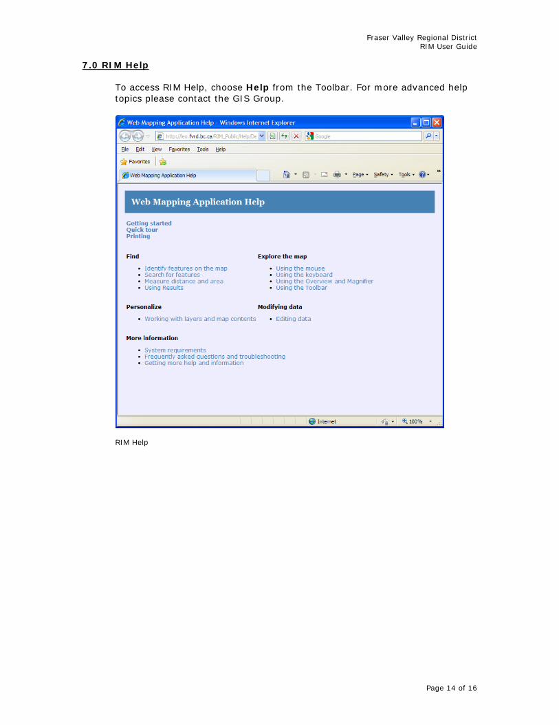
7.0 RIM Help
To access RIM Help, choose Help from the Toolbar. For more advanced help topics please contact the GIS Group.
RIM Help

Fraser Valley Regional District RIM User Guide
Page 15 of 16
8.0 RIM Tips and Techniques
Some tips for working with RIM are listed below. Users will be able to add to this list once they gain experience with the application and learn what works best for them. Turn off any map layers that are not of interest. This will not only speed
up display time but it will also create a cleaner looking map (i.e. uncheck unwanted layers in the Map Contents Menu of the Console).
While not necessary, the wildcard operator (“%”) can be used for searches
where the complete search string is not known (i.e. 997% Llanberis Way).
When searching for a property, it best to perform an initial search without the unit number (i.e. 45435 Knight Rd instead of 36-45435 Knight Rd). Should several addresses be returned, the search can be refined with the unit number.
Road types are abbreviated in RIM. When searching using the full road
name, use an abbreviated road type from the table below. Alternatively, use the wildcard character (i.e. McKay %).
Road Type Abbreviation
Avenue Ave Boulevard Blvd Circle Cir Close Close Court Crt Crescent Cres Crossing Cross Drive Dr Highway Hwy Hill Hill Lane Lane Parkway Pky Place Pl Road Rd Street St Terrace Terr Trail Trail Way Way Wynd Wynd
The correct format must be used for PID and Folio searches in RIM.
o The PID format is the same throughout the Regional
District. Dashes are used and the format is “xxx-xxx-xxx”.

Fraser Valley Regional District RIM User Guide
Page 16 of 16
o Folio formats differ depending on the jurisdiction. A list of the folio formats can be seen below.
Area Jurisdiction Folio Format
313 313.xxxxx-xxxx-x 324 324.xxxxx-xxxx-x City of Abbotsford
353 353.xxxxx-xxxx-x City of Chilliwack 303 303.xxxx-xxxxx District of Hope 432 432.xxxx-xxxxx District of Kent 310 310.xxxx-xxxxx District of Mission 314 314.xxxxxx-xxx Village of HHS 527 527.xxxx-xxxxx Electoral Area A 732 732.xxxxx.xxx Electoral Area B 732 732.xxxxx.xxx Electoral Area C (north) 776 776.xxxxx.xxx Electoral Area C (south) 775 775.xxxxx.xxx Electoral Area D 733 733.xxxxx.xxx Electoral Area E 733 733.xxxxx.xxx Electoral Area F (north) 742 742.xxxxx.xxx Electoral Area F (south) 775 775.xxxxx.xxx Electoral Area G 775 775.xxxxx.xxx Electoral Area G (Sumas Mtn) 734 734.xxxxx.xxx