ghana national spatial development framework …€¦ · land administration project ii ... 5.1...
TRANSCRIPT

GOVERNMENT OF GHANA MINISTRY OF LAND AND NATURAL RESOURCES
MINISTRY OF ENVIRONMENT, SCIENCE, TECHNOLOGY AND INNOVATION
TOWN AND COUNTRY PLANNING DPARTMENT
NATIONAL DEVELOPMENT PLANNING COMMISSION
FEBRUARY, 2015
GHANA NATIONAL SPATIAL DEVELOPMENT
FRAMEWORK (2015-2035)
ANNEXES
REPUBLIC OF GHANA

Ghana National Spatial Development Framework (2015-2035) Annex 1
2

Ghana National Spatial Development Framework (2015-2035) Annex 1
3
Government of Ghana
Ministry of Lands and Natural Resources Ministry of Environment, Science, Technology and Innovation Town and Country Planning Department National Development Planning Commission
Land Administration Project II
National Spatial Development
Framework 2015-2035
Space, Efficiency and Growth
FINAL REPORT
Annexes:
1. Projected GDP and Projects Costs
2. Strategic Environmental Assessment of NSDF
Credit #: IDA 4870 GH
Land Administration Project
Funded by the International Development Association (IDA)
Ghana National Spatial Development Framework (2015-2035) Annex 1
4
Annex 1:
Projected GDP and Projects Costs
Ghana National Spatial Development Framework (2015-2035) Annex 1
5
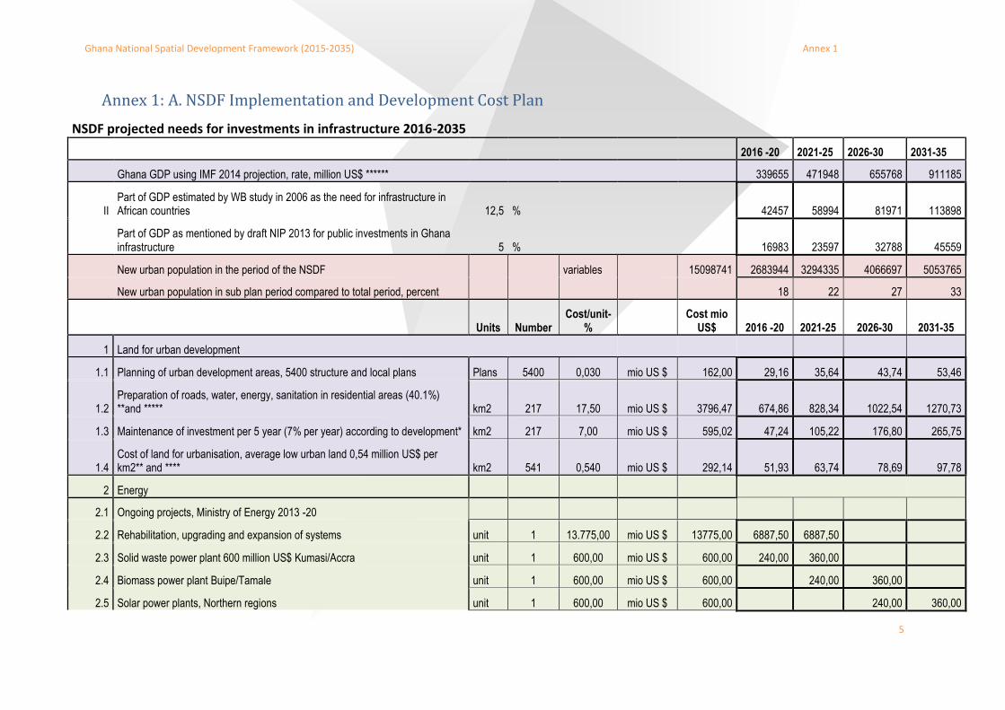
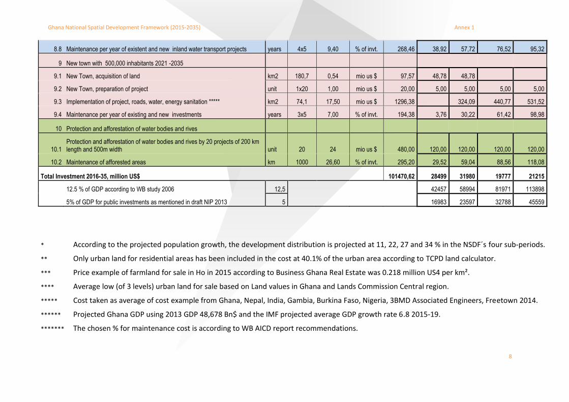
Annex 1: A. NSDF Implementation and Development Cost Plan
NSDF projected needs for investments in infrastructure 2016-2035
2016 -20 2021-25 2026-30 2031-35
Ghana GDP using IMF 2014 projection, rate, million US$ ****** 339655 471948 655768 911185
II Part of GDP estimated by WB study in 2006 as the need for infrastructure in African countries 12,5 %
42457 58994 81971 113898
Part of GDP as mentioned by draft NIP 2013 for public investments in Ghana infrastructure 5 % 16983 23597 32788 45559
New urban population in the period of the NSDF variables 15098741 2683944 3294335 4066697 5053765
New urban population in sub plan period compared to total period, percent 18 22 27 33
Units Number Cost/unit-
%
Cost mio US$ 2016 -20 2021-25 2026-30 2031-35
1 Land for urban development
1.1 Planning of urban development areas, 5400 structure and local plans Plans 5400 0,030 mio US $ 162,00 29,16 35,64 43,74 53,46
1.2 Preparation of roads, water, energy, sanitation in residential areas (40.1%) **and ***** km2 217 17,50 mio US $ 3796,47 674,86 828,34 1022,54 1270,73
1.3 Maintenance of investment per 5 year (7% per year) according to development* km2 217 7,00 mio US $ 595,02 47,24 105,22 176,80 265,75
1.4 Cost of land for urbanisation, average low urban land 0,54 million US$ per km2** and **** km2 541 0,540 mio US $ 292,14 51,93 63,74 78,69 97,78
2 Energy
2.1 Ongoing projects, Ministry of Energy 2013 -20
2.2 Rehabilitation, upgrading and expansion of systems unit 1 13.775,00 mio US $ 13775,00 6887,50 6887,50
2.3 Solid waste power plant 600 million US$ Kumasi/Accra unit 1 600,00 mio US $ 600,00 240,00 360,00
2.4 Biomass power plant Buipe/Tamale unit 1 600,00 mio US $ 600,00 240,00 360,00
2.5 Solar power plants, Northern regions unit 1 600,00 mio US $ 600,00 240,00 360,00
Ghana National Spatial Development Framework (2015-2035) Annex 1
6
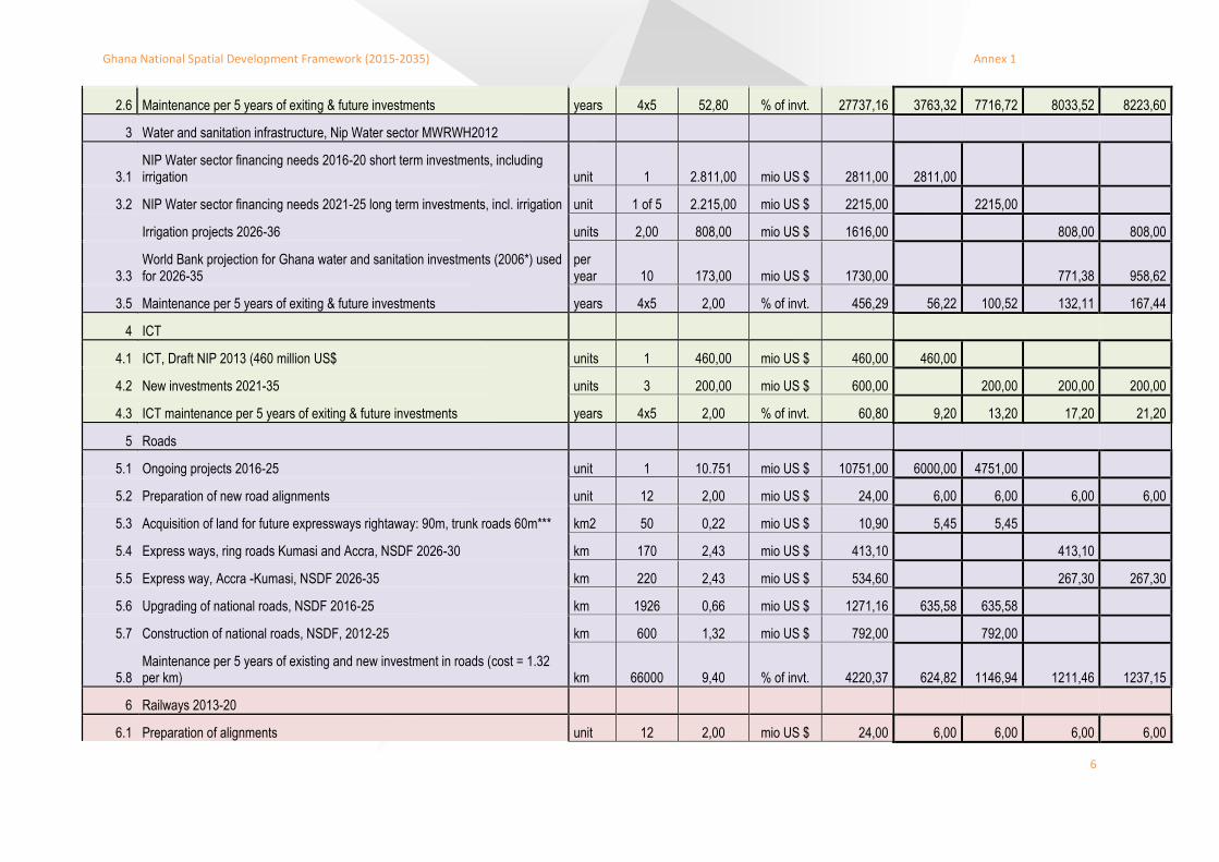
2.6 Maintenance per 5 years of exiting & future investments years 4x5 52,80 % of invt. 27737,16 3763,32 7716,72 8033,52 8223,60
3 Water and sanitation infrastructure, Nip Water sector MWRWH2012
3.1 NIP Water sector financing needs 2016-20 short term investments, including irrigation unit 1 2.811,00 mio US $ 2811,00 2811,00
3.2 NIP Water sector financing needs 2021-25 long term investments, incl. irrigation unit 1 of 5 2.215,00 mio US $ 2215,00 2215,00
Irrigation projects 2026-36 units 2,00 808,00 mio US $ 1616,00 808,00 808,00
3.3 World Bank projection for Ghana water and sanitation investments (2006*) used for 2026-35
per year 10 173,00 mio US $ 1730,00 771,38 958,62
3.5 Maintenance per 5 years of exiting & future investments years 4x5 2,00 % of invt. 456,29 56,22 100,52 132,11 167,44
4 ICT
4.1 ICT, Draft NIP 2013 (460 million US$ units 1 460,00 mio US $ 460,00 460,00
4.2 New investments 2021-35 units 3 200,00 mio US $ 600,00 200,00 200,00 200,00
4.3 ICT maintenance per 5 years of exiting & future investments years 4x5 2,00 % of invt. 60,80 9,20 13,20 17,20 21,20
5 Roads
5.1 Ongoing projects 2016-25 unit 1 10.751 mio US $ 10751,00 6000,00 4751,00
5.2 Preparation of new road alignments unit 12 2,00 mio US $ 24,00 6,00 6,00 6,00 6,00
5.3 Acquisition of land for future expressways rightaway: 90m, trunk roads 60m*** km2 50 0,22 mio US $ 10,90 5,45 5,45
5.4 Express ways, ring roads Kumasi and Accra, NSDF 2026-30 km 170 2,43 mio US $ 413,10 413,10
5.5 Express way, Accra -Kumasi, NSDF 2026-35 km 220 2,43 mio US $ 534,60 267,30 267,30
5.6 Upgrading of national roads, NSDF 2016-25 km 1926 0,66 mio US $ 1271,16 635,58 635,58
5.7 Construction of national roads, NSDF, 2012-25 km 600 1,32 mio US $ 792,00 792,00
5.8 Maintenance per 5 years of existing and new investment in roads (cost = 1.32 per km) km 66000 9,40 % of invt. 4220,37 624,82 1146,94 1211,46 1237,15
6 Railways 2013-20
6.1 Preparation of alignments unit 12 2,00 mio US $ 24,00 6,00 6,00 6,00 6,00
Ghana National Spatial Development Framework (2015-2035) Annex 1
7
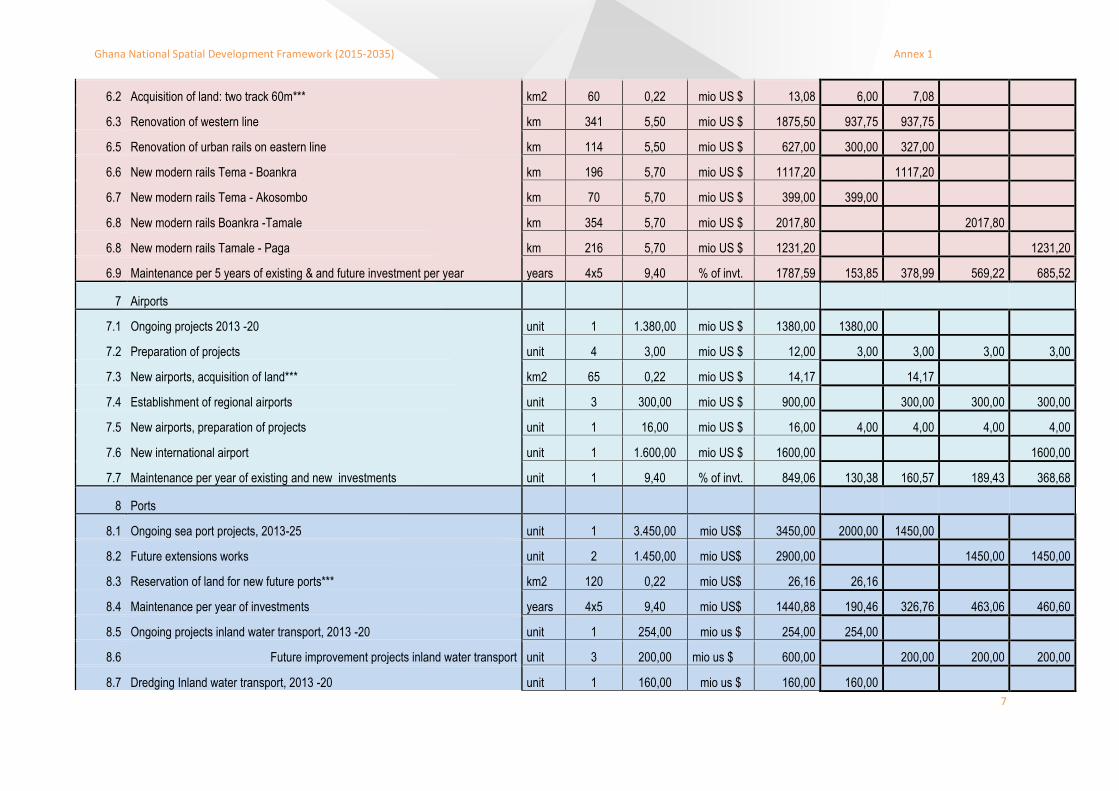
6.2 Acquisition of land: two track 60m*** km2 60 0,22 mio US $ 13,08 6,00 7,08
6.3 Renovation of western line km 341 5,50 mio US $ 1875,50 937,75 937,75
6.5 Renovation of urban rails on eastern line km 114 5,50 mio US $ 627,00 300,00 327,00
6.6 New modern rails Tema - Boankra km 196 5,70 mio US $ 1117,20 1117,20
6.7 New modern rails Tema - Akosombo km 70 5,70 mio US $ 399,00 399,00
6.8 New modern rails Boankra -Tamale km 354 5,70 mio US $ 2017,80 2017,80
6.8 New modern rails Tamale - Paga km 216 5,70 mio US $ 1231,20 1231,20
6.9 Maintenance per 5 years of existing & and future investment per year years 4x5 9,40 % of invt. 1787,59 153,85 378,99 569,22 685,52
7 Airports
7.1 Ongoing projects 2013 -20 unit 1 1.380,00 mio US $ 1380,00 1380,00
7.2 Preparation of projects unit 4 3,00 mio US $ 12,00 3,00 3,00 3,00 3,00
7.3 New airports, acquisition of land*** km2 65 0,22 mio US $ 14,17 14,17
7.4 Establishment of regional airports unit 3 300,00 mio US $ 900,00 300,00 300,00 300,00
7.5 New airports, preparation of projects unit 1 16,00 mio US $ 16,00 4,00 4,00 4,00 4,00
7.6 New international airport unit 1 1.600,00 mio US $ 1600,00 1600,00
7.7 Maintenance per year of existing and new investments unit 1 9,40 % of invt. 849,06 130,38 160,57 189,43 368,68
8 Ports
8.1 Ongoing sea port projects, 2013-25 unit 1 3.450,00 mio US$ 3450,00 2000,00 1450,00
8.2 Future extensions works unit 2 1.450,00 mio US$ 2900,00 1450,00 1450,00
8.3 Reservation of land for new future ports*** km2 120 0,22 mio US$ 26,16 26,16
8.4 Maintenance per year of investments years 4x5 9,40 mio US$ 1440,88 190,46 326,76 463,06 460,60
8.5 Ongoing projects inland water transport, 2013 -20 unit 1 254,00 mio us $ 254,00 254,00
8.6 Future improvement projects inland water transport unit 3 200,00 mio us $ 600,00 200,00 200,00 200,00
8.7 Dredging Inland water transport, 2013 -20 unit 1 160,00 mio us $ 160,00 160,00
Ghana National Spatial Development Framework (2015-2035) Annex 1
8
8.8 Maintenance per year of existent and new inland water transport projects years 4x5 9,40 % of invt. 268,46 38,92 57,72 76,52 95,32
9 New town with 500,000 inhabitants 2021 -2035
9.1 New Town, acquisition of land km2 180,7 0,54 mio us $ 97,57 48,78 48,78
9.2 New Town, preparation of project unit 1x20 1,00 mio us $ 20,00 5,00 5,00 5,00 5,00
9.3 Implementation of project, roads, water, energy sanitation ***** km2 74,1 17,50 mio us $ 1296,38 324,09 440,77 531,52
9.4 Maintenance per year of existing and new investments years 3x5 7,00 % of invt. 194,38 3,76 30,22 61,42 98,98
10 Protection and afforestation of water bodies and rives
10.1 Protection and afforestation of water bodies and rives by 20 projects of 200 km length and 500m width unit 20 24 mio us $ 480,00 120,00 120,00 120,00 120,00
10.2 Maintenance of afforested areas km 1000 26,60 % of invt. 295,20 29,52 59,04 88,56 118,08
Total Investment 2016-35, million US$ 101470,62 28499 31980 19777 21215
12.5 % of GDP according to WB study 2006 12,5
42457 58994 81971 113898
5% of GDP for public investments as mentioned in draft NIP 2013 5 16983 23597 32788 45559
* According to the projected population growth, the development distribution is projected at 11, 22, 27 and 34 % in the NSDF´s four sub-periods.
** Only urban land for residential areas has been included in the cost at 40.1% of the urban area according to TCPD land calculator.
*** Price example of farmland for sale in Ho in 2015 according to Business Ghana Real Estate was 0.218 million US4 per km².
**** Average low (of 3 levels) urban land for sale based on Land values in Ghana and Lands Commission Central region.
***** Cost taken as average of cost example from Ghana, Nepal, India, Gambia, Burkina Faso, Nigeria, 3BMD Associated Engineers, Freetown 2014.
****** Projected Ghana GDP using 2013 GDP 48,678 Bn$ and the IMF projected average GDP growth rate 6.8 2015-19.
******* The chosen % for maintenance cost is according to WB AICD report recommendations.

Ghana National Spatial Development Framework (2015-2035) Annex 1
9
Annex 1: B. Description of Budget Lines
Row ii: A WB study suggests the investment in infrastructure for an average African country to 12.5% of where 5% might be invested by the public sector and the remaining 7.5% by private sector.
Row iv:
The NSDF has projected the future urban population 2016-35 and the estimated urban population growth is presented in the four NSDF plan periods.
Row 1.1: Sums the needed development plans such as structure - and local plans to be prepared in the 216 municipalities and districts during the plan period and include the cost of preparation to an average cost of around 90,000 Ghana Cedi per plan. Contributions from developers are not included.
Row 1.2:
Presents the needed investment in infrastructure in the new demanded residential areas calculating the area by using the TCDP land need standards and using calculated cost of infrastructure per km2, including roads, sewage, electricity and water systems. The NSDF only considers the investments in residential areas, since the public participation in this development will be high as the majority of the population is without means to contribute to the initial development. The other urban functions might have a considerable contribution from private sector and developers.
Row 1.3:
All investments in infrastructure need maintenance and this has a cost to ensure continuous well-functioning infrastructure. The cost of maintenance is depending of the type of infrastructure. NSDF has used a WB study suggestion of 7% for investment in basic infrastructure. The cost is the global cost and does not take into consideration any reduction by consumer payments, fee or contributions.
Row 1.4:
This row gives the estimate cost of land for residential development in the NSDF plan period using TCDP standards for population densities and an average price of land in the outskirts of the urban areas in all regions. The price of land has been included as public participation and will be necessary to ensure well planned residential areas for the vast low income population demanding settlements in the plan periods and reduce land conflicts.
Row 2.1: This budget line presents the suggested NIP investments in energy generation concentrated in the two first plan periods 2016-25 according to their implementation schedules.
Row 2.2-4: Presents the NSDF investment in NSDF proposed power plants in the plan periods using an average cost of 600 million US$ for the construction of a power plant.
Row 2.5: Presents the cost of maintenance and running cost of the energy investments, which is quite high. The cost does not take into consideration consumer fees and sale of energy, which will reduce the actual maintenance and running cost.
Row 3.1-2: Presents the suggested NIP investments in water sector projects during the period 2016-2015 according to their implementation schedules.
Row 3.3: Presents NSDF estimation of investment in irrigation to develop agriculture in the period 2026-35

Ghana National Spatial Development Framework (2015-2035) Annex 1
10
Row 3.4: Presents the needs for investment in urban water and sanitation using a WB estimation of the needs per year projected to the plan period 2026-35. The period 2016-25 is expected to be covered by the planned ongoing projects.
Row 3.5: Presents the cost of maintenance and running cost of the water sector infrastructure using a cost equivalent of 2% per year as suggested by the WB.
Row 4.1: Presents the suggested NIP investments in ICT sector projects during the period 2016-2020 according to their implementation schedules.
Row 4.2:
Presents the NSDF estimate of needed investment in ICT during the plan period 2021-35 according to the WB suggestions for investment in ICT. These investments will primarily be done by the private sector although the public sector will have responsibilities for development of the important ICT development in education and public sector in general.
Row 4.3: Presents the needed investment in maintenance and running cost of ICT infrastructure.
Row 5.1: Presents the suggested NIP investments in road sector during the period 2016-2025 according to their implementation schedules.
Row 5.2: Presents the cost of planning and preparation of new road projects 2016-25.
Row 5.3: Presents the cost of acquisition of land 2016-25 for the NSDF suggested expressways. The price estimate has been calculated based on market prices for farm land January 2015 according to Business Ghana Real Estate, 0.218 million US4 per km2.
Row 5.4: Presents the cost of construction of the NSDF proposed expressways needed around Accra and Kumasi to handle distribution of road traffic 2025-30.
Row 5.5: Presents the cost of construction of the NSDF suggested expressway Accra - Kumasi to connect these principal cities and link them to new airport development in the “triangle”, 2026-35.
Row 5.6-7: Presents the cost of construction of the NSDF suggested trunk road improvements and construction of new trunk road links in Ghana in the period 2016-25.
Row 5.8: Sums the needed expenditures in maintenance of the existing and new constructed roads in the NSDF planning period 2016-35. Eventual income from toll roads has not been included. It is suggested that for all sectors GoG have to give thorough considerations to cost-recovery.
Row 6.1: Presents the cost of studies and preparation of the railway alignments and projects 2016-35.
Row 6.2: Presents the cost related to acquisition of land for adjustment of existing and new railway alignments according to the NSDF. The price has been calculated based on market prices as for new roads alignments Row 5.3.
Row 6.3: Calculates the price for the renovation of the western railway line Takoradi - Kumasi based on costs presented in paragraph 7.4.2 Railways.
Row 6.4: The row presents the estimated cost for the renovation and activation of the urban railway lines 2016-2025 on existing alignments Kumasi – Ejisu – Konongo and the railway stretch Accra - Koforidua.
Ghana National Spatial Development Framework (2015-2035) Annex 1
11
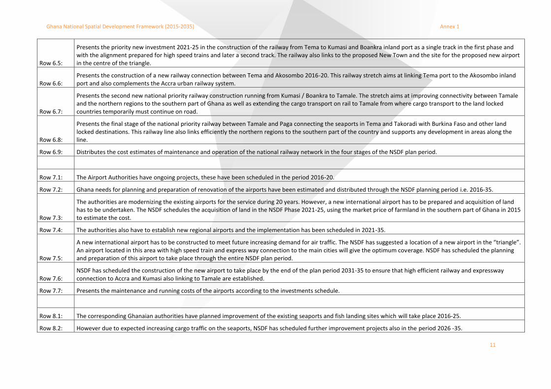
Row 6.5:
Presents the priority new investment 2021-25 in the construction of the railway from Tema to Kumasi and Boankra inland port as a single track in the first phase and with the alignment prepared for high speed trains and later a second track. The railway also links to the proposed New Town and the site for the proposed new airport in the centre of the triangle.
Row 6.6: Presents the construction of a new railway connection between Tema and Akosombo 2016-20. This railway stretch aims at linking Tema port to the Akosombo inland port and also complements the Accra urban railway system.
Row 6.7:
Presents the second new national priority railway construction running from Kumasi / Boankra to Tamale. The stretch aims at improving connectivity between Tamale and the northern regions to the southern part of Ghana as well as extending the cargo transport on rail to Tamale from where cargo transport to the land locked countries temporarily must continue on road.
Row 6.8:
Presents the final stage of the national priority railway between Tamale and Paga connecting the seaports in Tema and Takoradi with Burkina Faso and other land locked destinations. This railway line also links efficiently the northern regions to the southern part of the country and supports any development in areas along the line.
Row 6.9: Distributes the cost estimates of maintenance and operation of the national railway network in the four stages of the NSDF plan period.
Row 7.1: The Airport Authorities have ongoing projects, these have been scheduled in the period 2016-20.
Row 7.2: Ghana needs for planning and preparation of renovation of the airports have been estimated and distributed through the NSDF planning period i.e. 2016-35.
Row 7.3:
The authorities are modernizing the existing airports for the service during 20 years. However, a new international airport has to be prepared and acquisition of land has to be undertaken. The NSDF schedules the acquisition of land in the NSDF Phase 2021-25, using the market price of farmland in the southern part of Ghana in 2015 to estimate the cost.
Row 7.4: The authorities also have to establish new regional airports and the implementation has been scheduled in 2021-35.
Row 7.5:
A new international airport has to be constructed to meet future increasing demand for air traffic. The NSDF has suggested a location of a new airport in the “triangle”. An airport located in this area with high speed train and express way connection to the main cities will give the optimum coverage. NSDF has scheduled the planning and preparation of this airport to take place through the entire NSDF plan period.
Row 7.6: NSDF has scheduled the construction of the new airport to take place by the end of the plan period 2031-35 to ensure that high efficient railway and expressway connection to Accra and Kumasi also linking to Tamale are established.
Row 7.7: Presents the maintenance and running costs of the airports according to the investments schedule.
Row 8.1: The corresponding Ghanaian authorities have planned improvement of the existing seaports and fish landing sites which will take place 2016-25.
Row 8.2: However due to expected increasing cargo traffic on the seaports, NSDF has scheduled further improvement projects also in the period 2026 -35.
Ghana National Spatial Development Framework (2015-2035) Annex 1
12
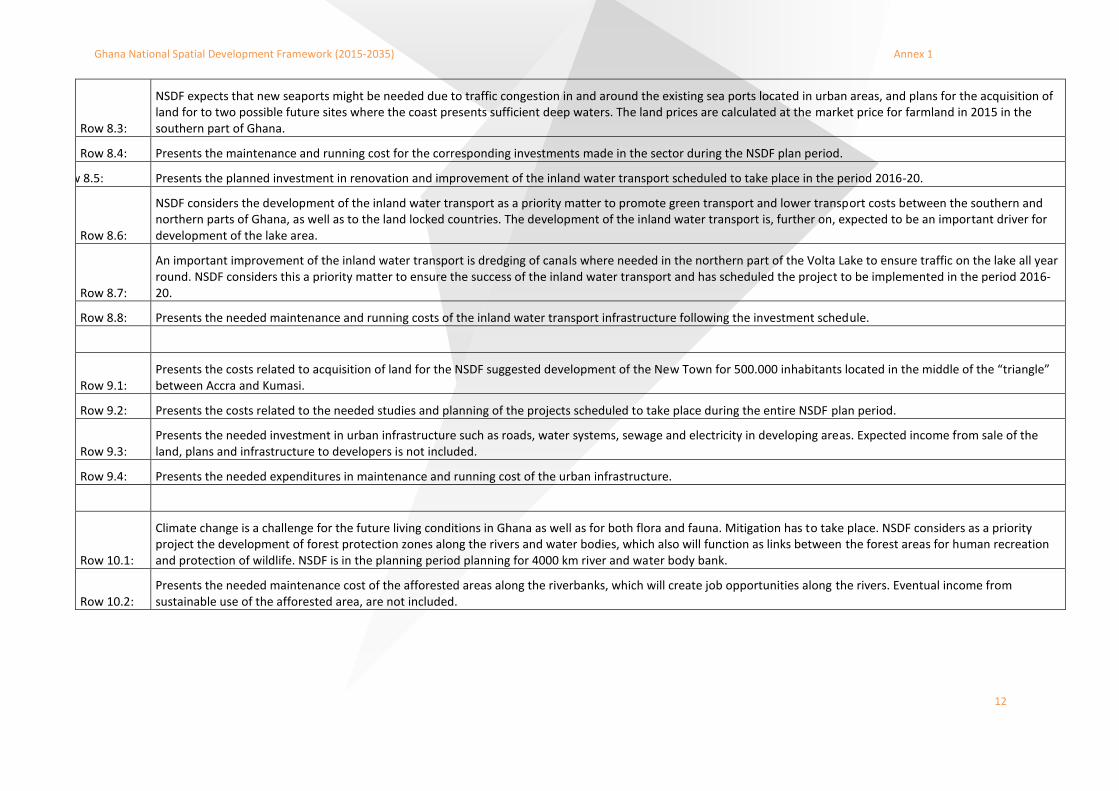
Row 8.3:
NSDF expects that new seaports might be needed due to traffic congestion in and around the existing sea ports located in urban areas, and plans for the acquisition of land for to two possible future sites where the coast presents sufficient deep waters. The land prices are calculated at the market price for farmland in 2015 in the southern part of Ghana.
Row 8.4: Presents the maintenance and running cost for the corresponding investments made in the sector during the NSDF plan period.
Row 8.5: Presents the planned investment in renovation and improvement of the inland water transport scheduled to take place in the period 2016-20.
Row 8.6:
NSDF considers the development of the inland water transport as a priority matter to promote green transport and lower transport costs between the southern and northern parts of Ghana, as well as to the land locked countries. The development of the inland water transport is, further on, expected to be an important driver for development of the lake area.
Row 8.7:
An important improvement of the inland water transport is dredging of canals where needed in the northern part of the Volta Lake to ensure traffic on the lake all year round. NSDF considers this a priority matter to ensure the success of the inland water transport and has scheduled the project to be implemented in the period 2016-20.
Row 8.8: Presents the needed maintenance and running costs of the inland water transport infrastructure following the investment schedule.
Row 9.1: Presents the costs related to acquisition of land for the NSDF suggested development of the New Town for 500.000 inhabitants located in the middle of the “triangle” between Accra and Kumasi.
Row 9.2: Presents the costs related to the needed studies and planning of the projects scheduled to take place during the entire NSDF plan period.
Row 9.3: Presents the needed investment in urban infrastructure such as roads, water systems, sewage and electricity in developing areas. Expected income from sale of the land, plans and infrastructure to developers is not included.
Row 9.4: Presents the needed expenditures in maintenance and running cost of the urban infrastructure.
Row 10.1:
Climate change is a challenge for the future living conditions in Ghana as well as for both flora and fauna. Mitigation has to take place. NSDF considers as a priority project the development of forest protection zones along the rivers and water bodies, which also will function as links between the forest areas for human recreation and protection of wildlife. NSDF is in the planning period planning for 4000 km river and water body bank.
Row 10.2: Presents the needed maintenance cost of the afforested areas along the riverbanks, which will create job opportunities along the rivers. Eventual income from sustainable use of the afforested area, are not included.

1
Annex 2:
Strategic Environmental Assessment of the NSDF

2

3
FEBRUARY 2015
STRATEGIC
ENVIRONMENTAL
ASSESSMENT OF NATIONAL
GHANA SPATIAL
DEVELOPMENT
FRAMEWORK 2015-2035
ANNEX II ENVIRONMENTAL ASSESSMENT REPORT
ADDRESS COWI A/S
Parallelvej 2
2800 Kongens Lyngby
Denmark
TEL +45 56 40 00 00
FAX +45 56 40 99 99
WWW cowi.com


GHANA NATIONAL SPATIAL DEVELOPMENT FRAMEWORK (2015-2035)
7
CONTENTS 1 Non-technical summary 9
2 Introduction 12
2.1 NSDF 12
2.2 SEA process 13
2.3 Methodology 14
2.4 Criteria, indicators and data 15
3 Ghana today and the proposed planning initiatives in the NSDF 17
3.1 Perspectives and proposed planning initiatives in NSDF 17
4 Environmental status 22
4.2 The 0-alternative 28
5 Impacts of implementing the NSDF 29
5.2 Alternatives 32
6 Evaluation of possible impacts on the environmental factors 33
6.1 Human beings, population and human health 33
6.2 Biodiversity, flora and fauna 34
6.3 Area and soil 35
6.4 Water 36
6.5 Air 36
6.6 Climatic factors (energy, resources) 36
6.7 Cultural heritage 37
6.8 Landscape 37
7 Assessment in relation to environmental objectives 38
8 Monitoring and recommendations 40
9 References 41

GHANA NATIONAL SPATIAL DEVELOPMENT FRAMEWORK (2015-2035)
8

GHANA NATIONAL SPATIAL DEVELOPMENT FRAMEWORK (2015-2035)
9
1 Non-technical summary
Introduction
A National Spatial Development Framework (hereinafter NSDF) for Ghana has been drawn up by the Town and Country Planning Department in co-operation with the National Development Planning Commission, the Ministry of Lands and Natural Resources and the Ministry of Environment, Science, Technology and Innovation. The NSDF is supposed to become a governing framework for the coming 20 years in Ghana and it contains initiatives for a number of land use prescriptions and reservations of land for development purposes. These prescriptions and reservations are taken to be likely to incur significant impacts on the environment. For this reason a strategic environmental assessment (SEA) has been prepared for the NSDF.
This report contains the strategic environmental assessment of the draft NSDF for Ghana. It evaluates whether the initiatives and activities made possible in the framework can cause significant impact on the environment. Relevant to note that not all aspects have been considered herein, as this document is to serve as guidance for the specific EIAs to be undertaken in relation with concrete proposals in the Framework. It is recommended that TCPD in collaboration with EPA look at the environmental implication of the planning actions.
NSDF
The NSDF is the strategic framework for the spatial development in Ghana in the coming 20 years. The NSDF includes initiatives for better infrastructure, food supply, areas of certain focus and better education. All of these initiatives aim at improving a co-ordinated structure for the future development of the land-pool in general. The initiatives will at the same time contribute to accomplish some of the national objectives adopted for social-, infrastructural-, environmental- and agricultural development.
The framework is based on initiatives regarding:
› Better and co-ordinated infrastructure (roads, railways, harbours and airports)
› Food and agriculture (development of better food supply)
› Social development (Appointment of the northern region as focus area for development)
› Climate change (knowledge sharing of climate technology)
GHANA NATIONAL SPATIAL DEVELOPMENT FRAMEWORK (2015-2035)
10
Scoping
The SEA is focused on the likely environmental impacts on several factors identified in the scoping process deemed to be likely to have possible significant impact. Besides the scoping report, responses from different relevant authorities have defined the final content of the scoping. Thus, the following environmental impact factors are assessed in the SEA.
Human beings, including social welfare and health issues
Biodiversity, flora and fauna
› Land use and soil
› Air and climate
› Landscape and cultural heritage
› Water
› Climate
Expected environmental impacts
It can be concluded that the initiatives of the plan may entail a number of positive impacts on human beings, including social welfare and health issues, due to the creation of jobs, improved food supply and improved infrastructure for sanitation and for transportation of goods as well as improved education level. Locating new establishments, buildings, infrastructure and appointing agricultural areas can on the other hand have an impact on existing settlement patterns and human health due to possible increased air, water and soil pollution.
Conversion of land use will often affect nature conservation areas and may likely have negative impacts on biodiversity, flora and fauna. New infrastructures and new areas for urban development may become a barrier to some species and may increase the risk of pollution of water bodies, marine waters and habitats, soil and air quality. The use of proper planning and careful localization of development projects may lower the impacts on biodiversity, flora and fauna. By implementing the suggestion of a Green Infrastructure Network, this feature, may diminish the negative impacts on nature in general.
Integration of new land areas in development projects is one of the major impacts from implementation of the plan. In order to diminish the negative impacts, areas for specific development should be appointed and selected based on the further integration of SEAs in the detailed planning processes and subsequently on project level involve an Environmental Impact Assessment-process.
Water may be a scarce resource in some areas and likely positive impacts from a more prudent use of existing water resources based on prior assessment and appropriate planning may apply. Water quality and maintaining existing resources in order to make them available in the future is a key concern when implementing the plan as several of the initiatives may have an impact on water quality and use.
Initiatives regarding better education, knowledge sharing within the climate sector may lead to improved climate adaptation and lead to preventive measures that in the long run may diminish the overall climate impact. This is obtained by facilitating better knowledge and awareness of climatic impact factors and by investing in more climate-friendly solutions.
Changes in the present land use may have an impact on cultural heritage. This can be related to both area specific heritage and certain activities. In order to protect the cultural heritage it is recommended that prior assessment is applied in downstream decision making procedure in the planning system.

GHANA NATIONAL SPATIAL DEVELOPMENT FRAMEWORK (2015-2035)
11
Some initiatives in the framework can cause impact on the landscape by changing the present state through establishment of e.g. infrastructure projects. These may have small to great impact on the landscape depending on the project and placement.

GHANA NATIONAL SPATIAL DEVELOPMENT FRAMEWORK (2015-2035)
12
2 Introduction
A National Spatial Development Framework of Ghana has been elaborated for Government of Ghana, Ministry of Lands and Natural Resources, Ministry of Environment, Science, Technology and Innovation, Town and Country Planning Department, and National Development Planning Commission with support from the COWI technical Assistance team on behalf of the JV. Because of the framework's character there has to be conducted a SEA.
The purpose of this report is to determine whether the environmental issues, objectives and indicators identified in the scoping are to be considered to have significant impact.
The report is drawn up in a context where the first NSDF has been drafted as part of an implementation project for the new land use planning system in Ghana. The existing legislation is under revision and a new Land use and spatial planning Act is being processed in Parliament.
The environmental assessment covers both direct and indirect environmental impacts.
2.1 NSDF
The NSDF contains a broad as well as extensive description of the existing environmental baseline in Ghana. The description is based on a division into a baseline description covering a number of societal sectors and results in recommendations on future planning (location, type, etc.).
The NSDF is divided into seven main issues that are given priority in the framework:
› Economic development and spatial economy
› Population, urbanization and human settlement
› Infrastructure
› Food and agriculture
› Environment and land cover
› Social development
› Climate change
A more thorough review of the NSDF is found in chapter 3 herein.

GHANA NATIONAL SPATIAL DEVELOPMENT FRAMEWORK (2015-2035)
13
2.2 SEA process
The prevailing act on Environmental Impact Assessment requires that the NSDF is subjected to a SEA.
The present SEA evaluates the planning initiatives described as an intrinsic part of the NSDF. The evaluation covers the process of reaching the described planning initiatives as well as the project planning outcomes of the NSDF.
The evaluations carried out focus on the generic environmental trends that may be derived from the described planning initiatives. This will e.g. concern planning guidelines for new infrastructures (at large), the provision of planning guidelines for harbours, urban development and land use planning, etc. Possible environmental impacts caused by the described planning initiatives are based on the current knowledge of the NSDF. The SEA will not conclude whether initiatives in the NSDF later in the process are subjected to EIAs or regulated by other planning. Hence, specific impacts by any given initiative may on the basis of legal requirements be subjected to later environmental assessments (EIA and SEA – depending on the nature of decisions to be taken in due course), when implementing the described planning initiatives.
The process developed for the purpose of providing an environmental assessment involves the following principal steps:

GHANA NATIONAL SPATIAL DEVELOPMENT FRAMEWORK (2015-2035)
14
Figure 1 The five steps of SEA
2.3 Methodology
The assessment is carried out as an assessment of whether and to what extent likely significant environmental impacts on any of the environmental factors identified in the scoping report may occur. The criteria and indicators applied in the assessment are described in the sections below.
1. Scoping
Scoping of the SEA in order to focus on the likely significant environmental impacts. The proposed scope of the SEA is submitted to relevant environmental authorities for consultation.
2. Assesment of the likely significant impact on the NSDF
Darfting the environmental report containing assesment of the likely significant impacts (based on the scoping of environmental factors).
3. Public hearing
Submit the NSDF and SEA to public consultation. This process will allow the public and the involved authorities to make submissions about the likely significant impacts.
4. Approval and implementation of plan
Final approval and implementation of the NSDF. The responses from the hearing process will be published in this context.
5. Monitoring
implementation of the planned monitoring of the NSDF's environmental consequenses as described and evaluated in the SEA. The monitoring programme is adopted as part of the adoption of the NSDF.

GHANA NATIONAL SPATIAL DEVELOPMENT FRAMEWORK (2015-2035)
15
Included in this document is an assessment of whether the NSDF will impose a barrier to, or promote the achievement of environmental objectives that are adopted in other national and/or international policies within the environment.
The NSDF is a spatial framework covering the entire territory of Ghana. Thus, the SEA is principally covering the territory of Ghana.
2.4 Criteria, indicators and data
The impact assessment is based on a scoping report (COWI, 2014). In the scoping phase, the draft NSDF (version, November 2014) was analysed according to the described planning initiatives in the draft NSDF and the possible impacts on a number of environmental factors as defined in the relevant act:
› Human beings, population and human health (transport, waste management)
› biodiversity, flora and fauna
› area and soil
› water
› air
› climatic factors (energy, resources)
› cultural heritage
› landscape
In the table below, the identified criteria and indicators from the scoping necessary for the assessment are listed. The table also lists whether the assessment is based on qualitative or quantitative criteria.
The evaluated environmental impact factors can be both positive and negative. First of all, focus is on the expected changes the NSDF can result in. Subsequent, the impacts will be evaluated whether they are positive or negative.
Table 1 Criteria, indicators and basis for the assessment
Environmental
factor
Criteria for assessment Indicators Basis of
assessment
Biodiversity, flora
and fauna
Changes in biodiversity, flora and
fauna by loss of habitat,
fragmentation, etc.
Extent of changes to
biodiversity, flora and
fauna
Qualitative
Human beings,
population and
human health
Changes in employment and
growth
Changes in health care
Changes in education and
research
Extent of changes of
employment and growth
Extent of changes in health
care and public health
Extent of schools,
educational institutions and
possibilities for research
Quantitative

GHANA NATIONAL SPATIAL DEVELOPMENT FRAMEWORK (2015-2035)
16
Land use and soil Changes in land use, drainage
and pollution
Extent of changes in land
use and soil conditions
Qualitative
Water Changes in quality of
groundwater, watercourses,
surface water and coastal marine
areas.
Extent of changes in
quality of surface and
ground water, water
courses and coastal
marine areas
Qualitative
Air Changes in the air quality due to
initiatives or activities
Extent of changes in air
quality
Qualitative
Climatic factors Changes in use and
knowledge/research of
renewable energy
Changes in emissions of
greenhouse gas.
Extent of changes to
climatic factors
Qualitative
Landscape Changes of the existing
landscapes
Extent and nature of
impacts caused by the
NSDF
Qualitative
GHANA NATIONAL SPATIAL DEVELOPMENT FRAMEWORK (2015-2035)
17
3 Ghana today and the proposed planning initiatives in the NSDF
3.1 Perspectives and proposed planning initiatives in NSDF
The National Spatial Development Framework (NSDF) is a spatial strategy for achieving defined social, economic and environmental policies on the ground. It provides a picture of the likely and preferred development pattern for the next 20 years. The strategic vision includes perspectives and proposals for what kinds of development should take place, how much of it should occur, where this should happen, and how to make this happen.
Based on the draft NSDF document (version, November 2014), the headlines of the framework are extracted according to the issues that are addressed as the key issues in the NSDF:
› economic development and employment,
› population and urbanization,
› housing and infrastructure services,
› education and health care,
› tourism and leisure,
› transportation,
› communications,
› culture and nature and the environment
3.1.1 Economic development and spatial economy
The trends regarding the development of the national economy of Ghana is that there has been a shift from agriculture towards the service sector, as well as a shift from an economy primarily based in rural areas to an economy with a stronger urban area base.
Although, this shift is described as a basic trend there are no specific planning recommendations made for the future development of the economic development and spatial economy, but rather the trends with the market will dictate the course.

GHANA NATIONAL SPATIAL DEVELOPMENT FRAMEWORK (2015-2035)
18
Figure 1 Two options for alignment of the Trans West African Coastal highway
3.1.2 Population, urbanization and human settlements
The challenges are connected to rapid population growth, still greater differences between regions, migration towards urban areas (some areas sees population increase, other areas face a decrease in population), new settlements and inappropriate infrastructure.
The NSDF does not contain specific recommendations regarding population, urbanization and human settlements, but rather addresses the trends development.
3.1.3 Infrastructure
Growing urbanization require improvement of the infrastructural system, mainly roads and development of a highway system.
The NSDF includes specific

GHANA NATIONAL SPATIAL DEVELOPMENT FRAMEWORK (2015-2035)
19
recommendations and proposals on a number of links:
› Accra–Kumasi city-region highway as Phase 1 of the Ghana African highway link Accra–
Ouagadougou
› Kumasi–Paga highway as Phase 2 of the Ghana African highway link Accra–Ouagadougou
› Techiman–Sunyani–Kumasi highway
› Improvement of the TAH 7, Trans–West African Coastal Road
› Specific recommendations on how to improve and develop connectivity around and across Lake
Volta (due to agriculture, tourism and transport in general)
› Improvement of connectivity in Western Region (establishment of six new links between urban
centres) in order to support agricultural production
› Considerations on constructing a new international airport to improve competitiveness. Four
locations have over time been taken into consideration, the NSDF points out two locations;
Tamale in the north and a non-specific location in the southern part of the country preferably in
the middle of the Triangle
› Options for three new seaports, including expansion of two seaports near Tema and one near
Takoradi. Available land and connectivity to rail and road are considered for these locations
› Proposal for a new railway network and modernization of existing railway lines. Focus is put on
the Triangle Area, where high speed connections are recommended
› Establishment of a new town in the centre of the Triangle area (New Airport City) in order to meet
requests for housing and to situate well-planned industries, ensure adequate service regarding
power supply, waste and water.
3.1.4 Food and agriculture
The recommendations are concerned with optimizing existing farmland and methods of cultivation. This includes knowledge on crops based on surveys and analysis regarding; farming methods, soil-type, water supply, intercropping, etc.
Establishment of urban food sheds is proposed as a concept to be further promoted. Urban food sheds strategically situated in a radius around the bigger cities will help secure the flow and greater access to fresh food for nearby population.
The NSDF points to the fact that Ghana has the conditions and can gain from appointing an Agricultural Growth Corridor (AGC). The corridor must access major infrastructure, warehouses and irrigation and is suggested to consist of areas/regions within 50 km from the designated main trunk roads. To implement AGC, there must be public-private coordination to ensure collaboration and it is expected, that there will be investments in and along any appointed AGC corridor.
GHANA NATIONAL SPATIAL DEVELOPMENT FRAMEWORK (2015-2035)
20
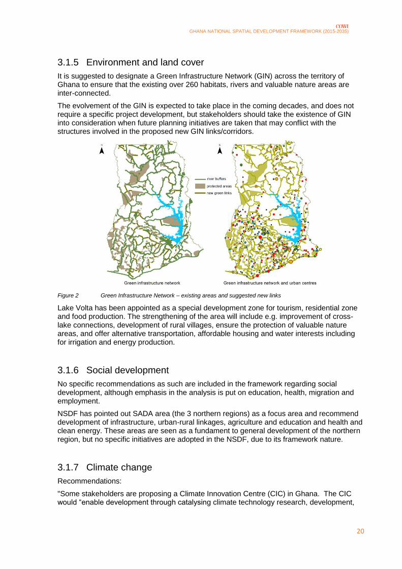
3.1.5 Environment and land cover
It is suggested to designate a Green Infrastructure Network (GIN) across the territory of Ghana to ensure that the existing over 260 habitats, rivers and valuable nature areas are inter-connected.
The evolvement of the GIN is expected to take place in the coming decades, and does not require a specific project development, but stakeholders should take the existence of GIN into consideration when future planning initiatives are taken that may conflict with the structures involved in the proposed new GIN links/corridors.
Figure 2 Green Infrastructure Network – existing areas and suggested new links
Lake Volta has been appointed as a special development zone for tourism, residential zone and food production. The strengthening of the area will include e.g. improvement of cross-lake connections, development of rural villages, ensure the protection of valuable nature areas, and offer alternative transportation, affordable housing and water interests including for irrigation and energy production.
3.1.6 Social development
No specific recommendations as such are included in the framework regarding social development, although emphasis in the analysis is put on education, health, migration and employment.
NSDF has pointed out SADA area (the 3 northern regions) as a focus area and recommend development of infrastructure, urban-rural linkages, agriculture and education and health and clean energy. These areas are seen as a fundament to general development of the northern region, but no specific initiatives are adopted in the NSDF, due to its framework nature.
3.1.7 Climate change
Recommendations:
"Some stakeholders are proposing a Climate Innovation Centre (CIC) in Ghana. The CIC would “enable development through catalysing climate technology research, development,

GHANA NATIONAL SPATIAL DEVELOPMENT FRAMEWORK (2015-2035)
21
market creation and policy” as well as facilitate knowledge sharing and private sector investments."
Further, NSDF comprises thoughts on alternative energy derived from biomass, solid waste, solar and wind energy.

GHANA NATIONAL SPATIAL DEVELOPMENT FRAMEWORK (2015-2035)
22
4 Environmental status
This chapter summarizes the main points from the NSDF relevant to the SEA. Because NSDF gives a thorough review on the environmental status, further knowledge has not been collected on the topic. In this way all data, knowledge and sources are the same as in NSDF.
4.1.1 Economic development and the Spatial Development Framework
In the period 1994 to 2013, Ghana has experienced a growing economy. In the period 2009-2011, the growth rate has increased due to a start up in oil production. However, several factors as inflation and weakening currency have led to a slowdown in growth in the period 2011 to 2013. Despite this downturn, the medium term prospect for growth remain positive. GDP and GDP rate are illustrated in Figure 34.
Figure 3 GDP and GDP growth rate in Ghana in the period 1994-2013
In terms of trade products mainly primary commodities, primarily gold, cocoa and crude oil (since 2011) dominate the Ghana's trade. The most important trading partners are Europe and China. As illustrated in Figure 4 primary commodities have in long periods dominated the market, with presently, crude oil as the second largest export commodity.

GHANA NATIONAL SPATIAL DEVELOPMENT FRAMEWORK (2015-2035)
23
Figure 4 Exports by category in Ghana in the period 2003-2012
Over 40 percent of the total work force is employed in the agricultural sector and its importance should not be underestimated. Cocoa, timber and other non-traditional agricultural products (cash crops) are an important earner of foreign exchange in the agricultural sector.
4.1.2 Population, urbanization and human settlements
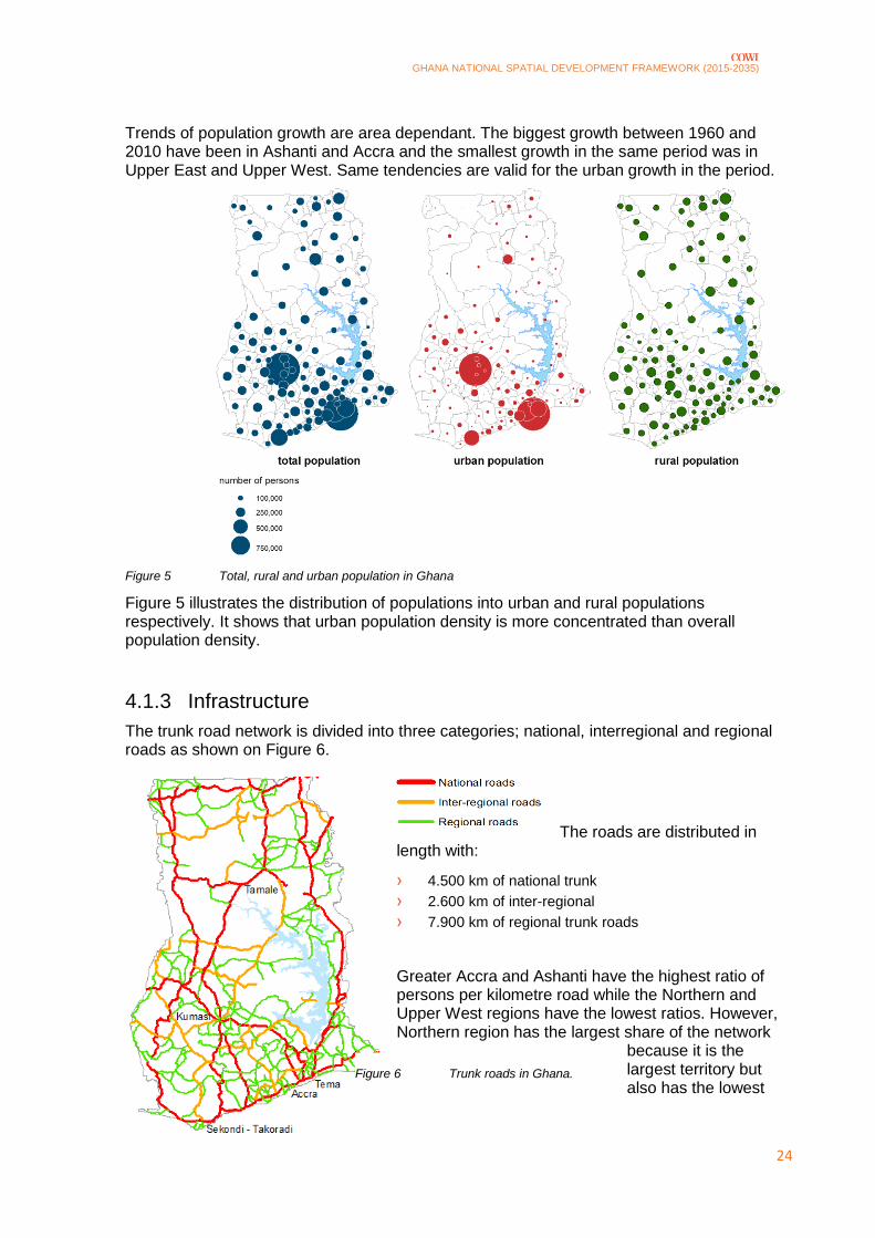
In the period 1960 to 2010, the urban population has grown from 1.5 million to 12 million whereas the total population has grown from 6 million to 24 million in the same period. Urbanisation level – or the percentage of population in urban areas compared to the national population – increased from about 23 percent in 1960 to over 51 percent in 2010, exceeding the rural population for the first time in history. In the same period, rural population increased from 5 million to 12 million.
GHANA NATIONAL SPATIAL DEVELOPMENT FRAMEWORK (2015-2035)
24
Figure 6 Trunk roads in Ghana.
Trends of population growth are area dependant. The biggest growth between 1960 and 2010 have been in Ashanti and Accra and the smallest growth in the same period was in Upper East and Upper West. Same tendencies are valid for the urban growth in the period.
Figure 5 Total, rural and urban population in Ghana
Figure 5 illustrates the distribution of populations into urban and rural populations respectively. It shows that urban population density is more concentrated than overall population density.
4.1.3 Infrastructure
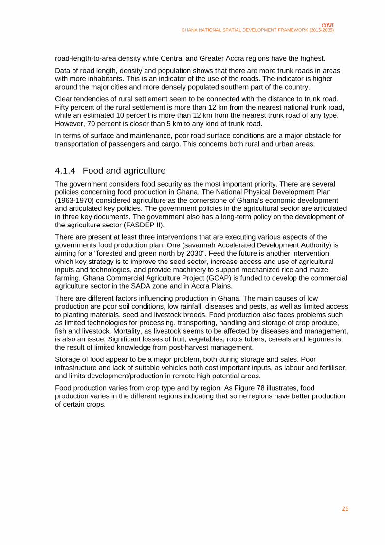
The trunk road network is divided into three categories; national, interregional and regional roads as shown on Figure 6.
The roads are distributed in length with:
› 4.500 km of national trunk
› 2.600 km of inter-regional
› 7.900 km of regional trunk roads
Greater Accra and Ashanti have the highest ratio of persons per kilometre road while the Northern and Upper West regions have the lowest ratios. However, Northern region has the largest share of the network
because it is the largest territory but also has the lowest
GHANA NATIONAL SPATIAL DEVELOPMENT FRAMEWORK (2015-2035)
25
road-length-to-area density while Central and Greater Accra regions have the highest.
Data of road length, density and population shows that there are more trunk roads in areas with more inhabitants. This is an indicator of the use of the roads. The indicator is higher around the major cities and more densely populated southern part of the country.
Clear tendencies of rural settlement seem to be connected with the distance to trunk road. Fifty percent of the rural settlement is more than 12 km from the nearest national trunk road, while an estimated 10 percent is more than 12 km from the nearest trunk road of any type. However, 70 percent is closer than 5 km to any kind of trunk road.
In terms of surface and maintenance, poor road surface conditions are a major obstacle for transportation of passengers and cargo. This concerns both rural and urban areas.
4.1.4 Food and agriculture
The government considers food security as the most important priority. There are several policies concerning food production in Ghana. The National Physical Development Plan (1963-1970) considered agriculture as the cornerstone of Ghana's economic development and articulated key policies. The government policies in the agricultural sector are articulated in three key documents. The government also has a long-term policy on the development of the agriculture sector (FASDEP II).
There are present at least three interventions that are executing various aspects of the governments food production plan. One (savannah Accelerated Development Authority) is aiming for a "forested and green north by 2030". Feed the future is another intervention which key strategy is to improve the seed sector, increase access and use of agricultural inputs and technologies, and provide machinery to support mechanized rice and maize farming. Ghana Commercial Agriculture Project (GCAP) is funded to develop the commercial agriculture sector in the SADA zone and in Accra Plains.
There are different factors influencing production in Ghana. The main causes of low production are poor soil conditions, low rainfall, diseases and pests, as well as limited access to planting materials, seed and livestock breeds. Food production also faces problems such as limited technologies for processing, transporting, handling and storage of crop produce, fish and livestock. Mortality, as livestock seems to be affected by diseases and management, is also an issue. Significant losses of fruit, vegetables, roots tubers, cereals and legumes is the result of limited knowledge from post-harvest management.
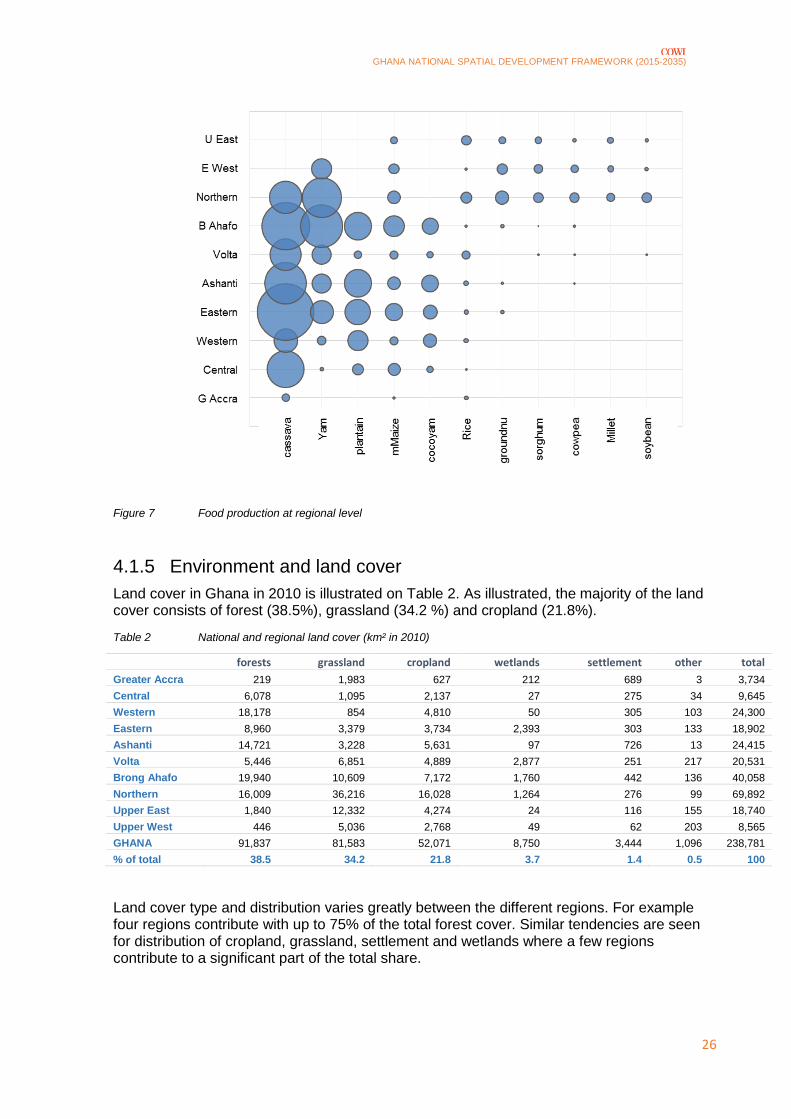
Storage of food appear to be a major problem, both during storage and sales. Poor infrastructure and lack of suitable vehicles both cost important inputs, as labour and fertiliser, and limits development/production in remote high potential areas.
Food production varies from crop type and by region. As Figure 78 illustrates, food production varies in the different regions indicating that some regions have better production of certain crops.
GHANA NATIONAL SPATIAL DEVELOPMENT FRAMEWORK (2015-2035)
26
Figure 7 Food production at regional level
4.1.5 Environment and land cover
Land cover in Ghana in 2010 is illustrated on Table 2. As illustrated, the majority of the land cover consists of forest (38.5%), grassland (34.2 %) and cropland (21.8%).
Table 2 National and regional land cover (km² in 2010)
forests grassland cropland wetlands settlement other total
Greater Accra 219 1,983 627 212 689 3 3,734
Central 6,078 1,095 2,137 27 275 34 9,645
Western 18,178 854 4,810 50 305 103 24,300
Eastern 8,960 3,379 3,734 2,393 303 133 18,902
Ashanti 14,721 3,228 5,631 97 726 13 24,415
Volta 5,446 6,851 4,889 2,877 251 217 20,531
Brong Ahafo 19,940 10,609 7,172 1,760 442 136 40,058
Northern 16,009 36,216 16,028 1,264 276 99 69,892
Upper East 1,840 12,332 4,274 24 116 155 18,740
Upper West 446 5,036 2,768 49 62 203 8,565
GHANA 91,837 81,583 52,071 8,750 3,444 1,096 238,781
% of total 38.5 34.2 21.8 3.7 1.4 0.5 100
Land cover type and distribution varies greatly between the different regions. For example four regions contribute with up to 75% of the total forest cover. Similar tendencies are seen for distribution of cropland, grassland, settlement and wetlands where a few regions contribute to a significant part of the total share.

GHANA NATIONAL SPATIAL DEVELOPMENT FRAMEWORK (2015-2035)
27
In two decades from 1990 to 2010 land cover has changed. By looking at grassland, forests, cropland, wetlands and settlement most of the land cover types have increased. The only exception is grassland that has decreased in the period. Forest area has in the same period increased together with cropland, wetlands and settlement. The biggest changes are seen in grassland and cropland.
The regions offer sites with different interest for tourists. These sites vary from castles, forests, Lake Volta, Botanical gardens, waterfalls, Bunso Arboretum, Nzulezu stilts, beaches, national parks, animal parks and markets as well as historical urban areas. The national Tourism Development Plan 2013-2027 identifies the Accra, Kumasi and Cape Coast Triangle as spatial footprint of tourist attractions with three spurs. These among other things include beaches, national parks and Ramsar sites.
4.1.6 Social development
Social development is divided into categories of education, health, housing, poverty, gender and development and social welfare.
The Government of Ghana Education Strategic Plan 2010-2020 includes strategies of education of different levels including, basic, post basic, non-formal, tertiary education and education management. In the Medium Term National Development Policy Framework 2008-2013, the Government of Ghana has a vision to "achieve a knowledge based and innovative corps of men and women who are able to transform Ghana’s economy and compete effectively in a globalized world ". It is a tendency that the most urbanised regions generally have better educated populations than others.
The Ministry of health's vision and objectives regarding the national health include long, healthy and productive livelihoods with reproduction without risk of injury or death, a general reduction of risk to health care and access to healthcare and nutrition services. Health care facilities vary greatly between the different regions.
Ghana has a National Housing Policy aiming at provision of adequate, decent and affordable housing. Some of the policies aims of provision of basic services as drinking water and sanitation, improvement of existing housing stock, supporting affordable housing for the poor and other. Some characteristics for housing in Ghana are the presence of slums in major cities, households increasing faster than rooms and predominance of one storey structure.
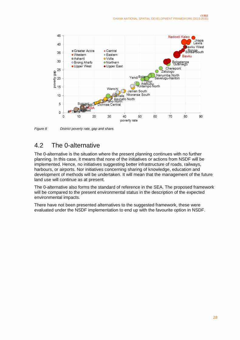
The rate of poverty varies in the regions. Hence, the share of the population below poverty line is highest in the three northern regions where poverty in the period 1992-2006 was above 50%. A more positive tendency is witnessed in other regions where a decline in poverty has been registered. Figure 8 illustrates poverty rate, gap and share for different districts in 2007.
GHANA NATIONAL SPATIAL DEVELOPMENT FRAMEWORK (2015-2035)
28
Figure 8 District poverty rate, gap and share.
4.2 The 0-alternative
The 0-alternative is the situation where the present planning continues with no further planning. In this case, it means that none of the initiatives or actions from NSDF will be implemented. Hence, no initiatives suggesting better infrastructure of roads, railways, harbours, or airports. Nor initiatives concerning sharing of knowledge, education and development of methods will be undertaken. It will mean that the management of the future land use will continue as at present.
The 0-alternative also forms the standard of reference in the SEA. The proposed framework will be compared to the present environmental status in the description of the expected environmental impacts.
There have not been presented alternatives to the suggested framework, these were evaluated under the NSDF implementation to end up with the favourite option in NSDF.

GHANA NATIONAL SPATIAL DEVELOPMENT FRAMEWORK (2015-2035)
29
5 Impacts of implementing the NSDF
This chapter contains an environmental assessment of the implementation of NSDF. In the following sections, the results of the assessment of possible environmental impacts caused by implementation of NSDF are presented.
Some of the initiatives and sub-activities have not yet concretized. These are marked as N/A in the scoping and will not be subjected to the assessment.
5.1.1 Economic development and the Spatial Development Framework
The topic is analysed with no further initiatives. Thus, it is not possible to make an assessment of the possible effects.
5.1.2 Population, urbanization and human settlements
The topic is analysed with no further initiatives. Thus, it is not possible to make an assessment of the possible effects.
5.1.3 Infrastructure
Several suggestions of new or improvement of existing infrastructure are made. These include:
› new or improved roads
› railroads
› airports
› harbours
› urban development
It also includes establishment of a new town.
The infrastructure projects will have specific impacts, these can be roughly described for roads and
railways, airports, harbours and construction of a new city. The common possible impacts are
described in continuation and then summarized.

GHANA NATIONAL SPATIAL DEVELOPMENT FRAMEWORK (2015-2035)
30
Roads and railways
Initiatives regarding establishment or renovation/improvement of roads and railroads can cause fragmentation and loss of valuable nature areas. Especially when establishing new connections, the intersection of green areas can affect areas functioning as green links. Besides, establishment of roads can cause road kill especially in areas with higher density of fauna and be a dangerous barrier for local habitants.
Airports
Building of airports may also cause fragmentation if placed in or between nature areas. Further, establishment of an airport will induce noise in and around the area. This can have consequences of land use sensitive to noise. This can e.g. be housing areas or nature areas with species sensitive to noise. Further, pavement of larger areas can have impact on soil and erosion during rainfall.
Harbours
Construction of harbours may cause damage or change of marine habitats due to construction or operation of the harbour. This can be caused by noise, areal consumption of habitats, spillage of contaminants or other pollution.
New city in triangle area
Construction of a new town in the triangle area between Accra, Kumasi and Takoradi can cause positive as well as negative impacts on human beings. Creation of the city may create jobs in the construction and operational phase. Further, the town will create residential areas and most likely better possibilities for retail and trade. In these terms, creation of the town may have positive effects on human beings. However, if planning of the town means placement in populated areas it can have negative impact on human beings.
Creation of a new town will require water supply and water treatment facilities and other infrastructure investments.
Common for all
The mentioned initiatives are all projects requiring larger areas. Whereas roads and railways require longer continuous lines or corridors in the landscape and have more local influence than airport, harbours and urban development which require larger areas and can influence on larger areas. Common for all initiatives mentioned above is the possible impacts on land use, landscape and cultural heritage. Initiatives affecting areas, landscapes or activities of cultural importance can cause impact on cultural heritage. Common for all the initiatives is also the possible impact on air quality and climate. Construction of roads, railways, airport and harbours will imply use of heavy machinery in the construction and operational phase. This can increase or reduce emissions in some areas by concentrating traffic in other areas where new infrastructure will be established.
Construction of the suggested initiatives will have impact on human beings and health. The initiatives can have positive affection on human beings by creating jobs. However, the initiatives will require larger areal use and hereby possibly taking existing jobs in the affected areas. This impact is not possible to specify further before having knowledge on the specific project such as location, extend, area use, etc. Construction of polluting or noisy infrastructure close to housing areas and agricultural fields may also constitute a human health risk.
GHANA NATIONAL SPATIAL DEVELOPMENT FRAMEWORK (2015-2035)
31
Better infrastructure will enhance the connectivity of the cities. This will ease transportation and reduce transportation time also making trade of goods easier.
In summary, the initiatives can lead to impacts on the environmental factors human beings, biodiversity, flora and fauna, soil and water, air and climate, landscape and cultural heritage.
5.1.4 Food and agriculture
Initiatives regarding food and agriculture are suggested via three activities.
Optimizing existing farmland and methods of cultivation
The activity will involve training, education and sharing of knowledge of cultivating crops. This
"educational" process will provide knowledge on how to optimize use of resources such as water,
seeds and nutrients and soil. This should contribute to better farming methods and help increasing the
yield of crops. Hence, the initiatives can lead to positive impacts on human beings, water, soil and
area use.
In summary, this activity can cause impact on the environmental factors Human beings, soil and water.
Urban food sheds
The concept is suggested, but with no specific situations, frequency or initiatives regarding who and how to get started. The purpose is to secure food supply to citizens of bigger cities in order to minimize diet-related illnesses and famine.
It is difficult to assess the impact from such an activity before having knowledge about the extent and exact locations. However, if applied, the activity will give a structure for urban development and traffic-solutions to this new type of distribution and will hence be a focus area. If the activity is successful, it can secure food-availability to the cities.
In summary, this activity can cause impact on the environmental factors, human beings and land use.
Agricultural Growth Corridor
Appointing an agricultural growth corridor will determine the land use in the appointed area. The corridor may create several new jobs and contributing to better food supply. Trade of goods may derive from this if the situation is favourable in terms of prices, transportation, demand and supply, etc. On the other hand, the current labour force in the area can be assigned to the agricultural corridor. When the borders of the corridor are known the current land use – and the possible change – within the borders can be identified. Only then, it will be possible to give further assessment of the impacts concerning human beings.
Appointing an agricultural corridor may reduce biodiversity in the area. This happens when larger areas are subjected to agricultural use (monocultures) that only allow biodiversity to a limited extent.
Use of resources within the corridor will change in relation to water supply and balance of nutrients. The agricultural use will require water and allocation of nutrients. This will most likely change the present condition of soil in terms of nutrients and drainage.
In summary, this activity can cause impact on the environmental factors human being, biodiversity, flora and fauna, water and soil.

GHANA NATIONAL SPATIAL DEVELOPMENT FRAMEWORK (2015-2035)
32
5.1.5 Environment and land cover
Green Infrastructure Network
N/A
Lake Volta – spatial development
N/A
5.1.6 Social development
Recommendations on social development
N/A
Northern region as focus area
There are no specific initiatives pointed out yet as these are incorporated in the SADA Development Strategy, but the area is designated as focus area for development of infrastructure, urban-rural linkage, agriculture, education and health. Development and improvement of these factors will improve conditions for human beings in terms of better health care, schools/education, better infrastructure, better food supply, trade of goods, etc.
Development of infrastructure and agricultural areas can cause fragmentation or loss of nature areas and biodiversity.
Development of agricultural areas can cause changes in usage of water and change drainage of lands.
However, until initiatives are specified and localized it is not possible to concretize the impact further on the available knowledge.
In summary, activities in this initiative can cause impacts on the factors: human beings, biodiversity, flora and fauna, soil and water.
5.1.7 Climate change
Climate Innovation Centre
The Climate Innovation Centre (CIC) will enable development through catalysing climate technology research, development, market creation and policy as well as facilitate sharing of knowledge. Such initiative can create jobs and facilitate education. Further, the aim is to develop better technologies and thereby reducing the impact on the climate.
In summary, there can be positive impact on the factors human beings and climate.
5.2 Alternatives
There are no alternatives to the suggested initiatives in NSDF. However, some of the suggested initiatives have still not been concretised. The initiatives and the pertaining activities have been evaluated in the environmental assessment in terms of the possible environmental impacts caused by NSDF.

GHANA NATIONAL SPATIAL DEVELOPMENT FRAMEWORK (2015-2035)
33
6 Evaluation of possible impacts on the environmental factors
In the following sections, impacts on the environmental factors from NSDF identified in the scoping and explained in the previous chapter are listed according to the specific environmental topic. It has to be pointed out that the possible impacts are based on the current knowledge. In the projecting of the projects the specific environmental impacts may be elucidated in relation with EIA.
6.1 Human beings, population and human health
Several of the initiatives and activities in NSDF can affect human beings, population and human health. The impacts can be both positive and negative.
Planning of better infrastructure can positively affect human beings. Better infrastructure creates better connectivity enhancing the possibilities for travelling, transporting and trading between cities, rural areas and the coastline. Better infrastructure will also improve accessibility to more northern parts of the country. A network of better infrastructure is expected primarily to have positive impacts on human beings due to better connectivity. However, creation of better infrastructure demands space. Some houses, urban-, agricultural- or nature areas can be subject to the planning of better infrastructure.
Building an airport will enhance connectivity in a greater perspective. This may improve the possibilities for more international business opportunities and travelling in general. It may also allow possible tourism to flourish and create jobs in the local area. Establishment of a new airport will potentially create several new jobs in the local area. Noise from the airport is an issue that is to be considered. Establishment of an airport will cause noise from the planes during take-off and landing. This can reduce the attractiveness of housing areas near the airport.
Depending on the purpose and type of harbour, it can enable shipping and thereby extend possibilities of sailing, trading, fishing and other marine activities, including trading with land locked neighbouring states. Establishment of a harbour allows more activities in the local area and this can enable new possibilities for trade and business, recreational activities and creation of jobs.
All initiatives regarding infrastructure, can change the current traffic flow. Depending of the initiative, current traffic conditions and future development and demand, the traffic can increase/decrease in local areas.
GHANA NATIONAL SPATIAL DEVELOPMENT FRAMEWORK (2015-2035)
34
Initiatives regarding training, education and sharing of knowledge of cultivating crops can positively benefit human beings. Provision of better knowledge of agricultural techniques and methods will potentially increase the yields from the individual fields and assure optimized use of soil. This can give better economy to the individual farmers and managers and improve food supply.
Urban food sheds should help distribution of fresh food to the still growing urban population in and around larger cities. The initiative has not been concretised but the idea is to provide access to food sources in the outer parts of urban areas. The concept can affect traffic patterns, but human beings can benefit from the food sources. Thus, the initiative will also require urban planning interventions.
Initiatives of appointing a growth corridor can benefit human beings both locally and regionally. Locally agricultural areas can create jobs and contribute to better food supply. Better food supply can benefit other parts of the country if the goods are exported. The present land use will, however, be subjected to the corridor and be involved in the agricultural use. Depending of the management, this can impact the people in the corridor.
Pointing out the northern part of the country as a regional development area can have positive impacts on human beings. Development of the infrastructure, improvement of health care, educational possibilities and better food supply can improve living standards.
Creation of a climate innovation centre will create development through climate technology research and knowledge sharing. The research can facilitate knowledge for policymaking within the topic. An initiative creating a centre as described will create jobs and maybe contribute to improved climatic solutions that human beings can benefit from in terms of both health and economic conditions, besides the energy sector and clean biomass energy.
6.1.1 Summary of impact assessment on human beings, population and human health
In summary, it can be concluded that the initiatives of the plan will entail many positive impacts on human beings due to creation of jobs, better food supply and transportation of trading goods as well as improve the educational level. Placing new establishments, buildings, infrastructure and designating agricultural areas can on the other hand impact on settlement pattern and human health due to possible increased air, water and soil pollution.
6.2 Biodiversity, flora and fauna
Initiatives regarding development and improvement of infrastructure can negatively affect biodiversity, flora and fauna. Establishment of roads in or between nature areas can cause fragmentation where especially species with poor ability of dispersal are exposed. Fragmentation can result in sub populations derived from a meta population if the degree of fragmentation is big enough.
Establishment of roads may also intersect valuable nature areas or landscape types functioning as green links. This also includes the possible reduction of nature areas when building roads and railways. Roads also present the possibility of collisions with fauna. This may especially be present in areas with higher densities of fauna.
New infrastructure can create noise periodically or permanently. The noise can have different impacts on fauna depending on the volume and the species. An airport needs to be placed with due consideration to fauna sensitive to noise e.g. some bird species.
GHANA NATIONAL SPATIAL DEVELOPMENT FRAMEWORK (2015-2035)
35
Establishment of a harbour can have impact on biodiversity, flora and fauna both on terrestrial and marine areas. The harbour can potentially cause impact on marine areas, flora and fauna caused by pollution and removal of sea bed. This can affect species sensitive to changes of habitat, noise and pollution.
Planning of an Agricultural Growth Corridor can eventually result in larger consistent areas of agricultural land use. Crops usually present monocultures only allowing biodiversity of low value. Larger areas of agricultural areas will thereby prevent flora and fauna to habituate in the area making poor biodiversity. Dispersal of species can be improved by preserving green links in the agricultural areas connecting adjacent nature areas.
6.2.1 Summary of impact assessment on biodiversity, flora and fauna
Conversion of land use will often affect nature areas and have negative impact on biodiversity, flora and fauna. New infrastructure and urban development can be a barrier to some species and the risk of pollution of water bodies, marine waters and habitats, soil and air quality will increase. Proper planning and localisation of development projects can decrease the impacts on biodiversity, flora and fauna. If implementing the suggestion of a Green Infrastructure Network, this can diminish the negative impacts.
6.3 Area and soil
Common for all initiatives concerning infrastructure is the issue of land use and occupation of areas. All projects will require a change in the present land use in a permanent matter. This will change the future area planning possibilities. Positively, establishment of infrastructure may allow other activities in local areas that were earlier limited by poor infrastructure. These, could be activities that require or benefit from the improved connectivity and better access in certain areas. On the other hand planning of infrastructure may in some cases impound other activities or area use in certain areas. It may also prevent other area planning in the specific areas where the infrastructure projects are implemented.
Education, training and sharing of knowledge can improve the yield of crops and may change conditions in terms of drainage, crops rendition, water needs and nutrition balance. Possible fertilization of the fields can change soil conditions.
Appointing an agricultural growth corridor can eventually change the present and future land use in the corridor. The growth corridor may result in monotonous areas of crops not allowing other types of areal use. On the other hand, unification of the agricultural area may induce development in other areas. The agricultural growth corridor may also require larger amounts of water and nutrient making a possible change to the soil and underground aquifers amongst other.
6.3.1 Summary of impact assessment on area and soil
Integration of new land areas in development projects is one of the major impacts from implementation of the plan. In order to diminish the negative impacts, areas for specific development should be appointed and selected based on an EIA-process.

GHANA NATIONAL SPATIAL DEVELOPMENT FRAMEWORK (2015-2035)
36
6.4 Water
Several of the initiatives can affect water in different ways regarding both ground water, surface water and marine water quality.
Initiatives concerning establishment of better infrastructure including a harbour can affect marine water quality. Pollution from the ships, spillage and marine activities can negatively affect marine water quality locally around the harbour.
Initiatives concerning infrastructure projects in general include pavement of larger areas. This will eventually result in draining of surface water, which in many cases may be polluted. This means, that these projects may require solutions for cleaning surface water (e.g. oil separator) before leading the water to recipient.
Construction of a new town will require water supply and facilities for treatment of wastewater. The construction may have a negative impact on the local water resource.
Education, knowledge sharing and training may enhance farming techniques optimizing and reducing the use of water. In this case, the initiative will have positive impact on the water resources.
An agricultural growth corridor will eventually require larger amount of water than if the initiative is not implemented. This can have negative impact on the water resource.
Pointing out the northern region as focus area may induce urban development creating a greater need of drinking water and sanitation treatment. The increased demands may impact and reduce local water resources.
6.4.1 Summary of impact assessment on water
Water may be a scarce resource in some areas and possible positive impacts from smarter use of existing water resources due to knowledge and appropriate planning may apply. Water quality and keeping existing resources available is a key concern when implementing the plan as several of the initiatives can affect water quality and use.
6.5 Air
Initiatives regarding infrastructure may -- depending on the extent, placement use etc.-- cause changes in the air quality. In some cases, it can have a positive effect by creating a more fluent traffic and less traffic jams in trafficked areas. In other cases, it may induce more air pollution by allowing more traffic or other air polluting activities into areas that have not yet been exposed in the same degree.
6.6 Climatic factors (energy, resources)
Initiatives suggesting development of the infrastructure can have both positive and negative effects on climate and resources depending on the extent and use. If the projects create a more fluid traffic, hence reducing congestions; the use of fuel may also be reduced. On the other hand, better infrastructure may also result in greater use and thereby greater use of fuel and a greater climate impact.
The initiative regarding a climate innovation centre may have positive impact on climate by improving methods, facilitating knowledge and developing better clean energy technologies.
GHANA NATIONAL SPATIAL DEVELOPMENT FRAMEWORK (2015-2035)
37
6.7 Cultural heritage
Initiatives suggesting better infrastructure includes construction of roads, airports, harbours and construction of a new town. This may result in reduction of or inclusion of areas of cultural interests with historic buildings, area use or activities. Possible consequences of planning new infrastructure can be elucidated later in the process when specific projects are planned. Hence, it is not possible to draw conclusions on the based knowledge.
6.8 Landscape
Initiatives suggesting new infrastructure of new roads, railways, airports, harbours and establishment of a new town may all result in activities that can have impact on the existing landscape. However, the impacts depend on the placement, size, profile and extent of the projects. Hence, it is not possible to concretise the impacts before the projection phase. Impact on landscape will also be elucidated in an eventual EIA also analysing other impacts.

GHANA NATIONAL SPATIAL DEVELOPMENT FRAMEWORK (2015-2035)
38
7 Assessment in relation to environmental objectives
SEA of the National Spatial Development Framework contains an assessment of whether the framework is expected to promote or prevent national and international environmental goals. These could be goals in the legislation, programmes or policies that may be affected by the initiatives of NSDF.
By going through legislation, strategies and policy agendas, the following environmental goals are found relevant. They need to be complemented and further elaborated between TCPD and EPA, together with a Monitoring and Evaluation Framework.
Subject Settings Assessment
Biodiversity
Climate
Health care and
humans
The Ghana Shared Growth and Development Agenda
(GSGDA)
› accelerated agricultural modernization and natural
resource management
› human development, productivity and employment
National Urban Policy and Action plan with the goal of:
› sustainable, spatially integrated and orderly
development of urban settlements with adequate
housing and services, efficient institutions, sound living
and working environment
Land Administration Project - II:
› improving business processes for service delivery
› human resource development and project
management
Air quality
GHANA NATIONAL SPATIAL DEVELOPMENT FRAMEWORK (2015-2035)
39
Biodiversity
Infrastructure Overall strategy by the National Infrastructure Plan
(NIP) is to:
› maintain the existing and outgoing routes for freight
and passenger transport including roads, rail inland
water and air travel
Main goal set by the Ministry of roads and highways is
to:
› maintain and improve Ghanaian road network
› establish Ghana as a transportation hub for the West
African sub-region
› create and sustain an efficient transport system that
meets user needs
› integrate land use, transport planning, development
planning and service provision
› and ensure sustainable development in the transport
sector
Ghana Road Authorities plan to use 26 percent of the
road infrastructure budget between 2013 and 2020 for
road maintenance.
The Ghana Shared Growth and Development Agenda
(GSGDA)
› infrastructure and human settlements development
Water
Land use Land Administration Project - II
› strengthening the policy, legal and regulatory
framework for land administration
GHANA NATIONAL SPATIAL DEVELOPMENT FRAMEWORK (2015-2035)
40
8 Monitoring and recommendations
Monitoring of the significant environmental impacts assessed in this report will need to take place within a process that is linked to the future planning stages of the NSDF. These future planning stages may be:
› the regularly undertaken five year update of the NSDF
› the complete redrafting of a second NSDF twenty years ahead from now
The generic nature of some of the impacts expected from the implementation of the NSDF in the coming years presupposes that monitoring will be undertaken at a quite overall and sometimes abstract/generic level.
One example could be that the designation of land for urban development purposes through NSDF should in essence provide several "environmental benefits", such as:
› the lowering of occurrences of illegal settlements in the periurban zones
› the improvement of general supplies of water, waste water facilities, electricity, etc. in newly
established urban zones
Monitoring such development will of course be quite general. One indicator by which this could be monitored could be to provide data on the number of new "illegal settlements", as well as numbers on new urban areas with full services and supplies within water, waste water facilities, waste management, and electricity.
The monitoring of the assessed environmental impacts should in essence feed into the regularly undertaken update of the NSDF, i.e. every five years. The formalities involved in providing monitoring input into the update of the NSDF every five years, could be to adopt a requirement for the TCPD, to set forth a short report as part of the justification for providing an update of the NSDF, in which brief monitoring data are reported.
The monitoring data should then be used as a potential reasoning for proposing specific updates to the NSDF for the coming five year period.
GHANA NATIONAL SPATIAL DEVELOPMENT FRAMEWORK (2015-2035)
41
9 References
COWI (2015): Scoping report of Ghana NSDF 2015-2035
COWI (2015): Ghana National Spatial Development Framework (2015-2035)