gis core database revision: gis data resource site ......gis data and infrastructure supervisor...
TRANSCRIPT

GIS Data Resource Site Specifications 7/8/2002
-1-
GIS Core Database Revision:
GIS Data Resource Site Specifications
August 24th, 2002
Robert MakiGIS Database and Infrastructure
SupervisorMinnesota DNRManagement Information Services
Bureau

GIS Data Resource Site Specifications 7/8/2002
1Minnesota DNR, Management Information Services Bureau, “Revised Core DatabaseGeneral Architecture Design”, March 2000
2Specifically: Minnesota DNR, Management Information Services Bureau, “GIS CoreDatabase Architecture Revision”, 1999.
-2-
Minnesota DNRGIS Data Resource Site Specifications
Robert MakiGIS Data and Infrastructure SupervisorMIS-GIS
1.0 Introduction
This document provides technical specifications for GIS Data Resource Sites at the MinnesotaDepartment of Natural Resources (DNR). Data Access Sites are part of the Revised GIS CoreDatabase Architecture,1 an information system initiative which seeks to created an integrated GISdata storage, access, distribution, and maintenance environment. The “Revised Core” initiativeupdates the original DNR GIS Core Database Architecture, which was established in 1995.
This document is intended for a technical audience, primarily system designers and applicationdevelopers. Reviewers seeking a general understanding of the architecture may wish to consultother sources.2 The specification has been prepared early in the Revised Core developmentproject because several yet to be developed subsystems depend on the specification.
Data Resource Sites are encapsulated data, application, and user documentation environments thatdefine the range of data resources available to users. Consolidating these resources into a singlesuite of structured locations facilitates data distribution and update, and software version control.
Data Resource Sites have several key characteristics, including: 1) may draw upon a wide varietyof physical data sources which are encapsulated through a set of system level metadata structures,2) includes not only data but also methods for accessing data, thereby enabling applications whichdo not require users to navigate file systems and data sources to load data into their applicationenvironment, 3) are organized, in part, around specific business units with an eye towardsupporting business-specific applications.
The document consists of several sections as follows:
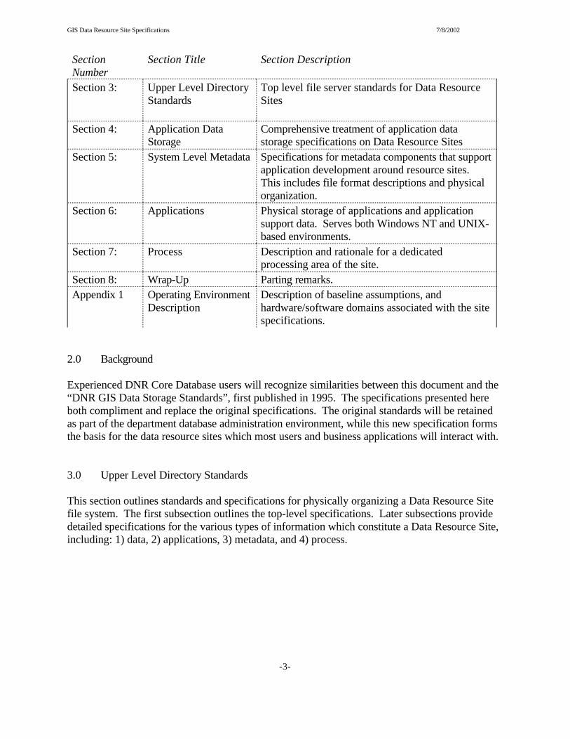
SectionNumber
Section Title Section Description
Section 2: Background Historical context for the document
GIS Data Resource Site Specifications 7/8/2002
SectionNumber
Section Title Section Description
-3-
Section 3: Upper Level DirectoryStandards
Top level file server standards for Data ResourceSites
Section 4: Application DataStorage
Comprehensive treatment of application datastorage specifications on Data Resource Sites
Section 5: System Level Metadata Specifications for metadata components that supportapplication development around resource sites. This includes file format descriptions and physicalorganization.
Section 6: Applications Physical storage of applications and applicationsupport data. Serves both Windows NT and UNIX-based environments.
Section 7: Process Description and rationale for a dedicatedprocessing area of the site.
Section 8: Wrap-Up Parting remarks.Appendix 1 Operating Environment
DescriptionDescription of baseline assumptions, andhardware/software domains associated with the sitespecifications.
2.0 Background
Experienced DNR Core Database users will recognize similarities between this document and the“DNR GIS Data Storage Standards”, first published in 1995. The specifications presented hereboth compliment and replace the original specifications. The original standards will be retainedas part of the department database administration environment, while this new specification formsthe basis for the data resource sites which most users and business applications will interact with.
3.0 Upper Level Directory Standards
This section outlines standards and specifications for physically organizing a Data Resource Sitefile system. The first subsection outlines the top-level specifications. Later subsections providedetailed specifications for the various types of information which constitute a Data Resource Site,including: 1) data, 2) applications, 3) metadata, and 4) process.

GIS Data Resource Site Specifications 7/8/2002
-4-
drs
Data ProcessApps MetadataResource TypeLevel
gis
<drs root location>
3.1 Top-Level Directory Specifications
Top-level directory structures of Data Resource Sites include A root location followed by twolevels named with “gis” and “drs” key words, followed by Resource Type Identifier level, asfollows:
3.2 Data Resource Site Identifier {this section has been withdrawn}
3.3 Resource Type
The resource type identifier indicates the major site component stored in the various branches ofthe filesystem below the resource site root. Four components exist at this level. These are listedbelow.
Resource Type Resource Description
data GIS filesystem based data resources storage
apps UNIX and NT-based applications, includingARCVIEW extensions. (Subdirectorystructures to be determined)
metadata System level metadata used by applications
process Designated scratch space for applicationprocesses. Intended to isolate temporary filesand system process files from data andapplication portions of the file system.

GIS Data Resource Site Specifications 7/8/2002
-5-
4.0 Application Data Storage
Application data constitute the full range of data types available to users, including: 1) fileserver-based GIS data, 2) database server resident GIS data, and 3) traditional (non-spatial) data servedvia a database server in a client-server environment.
4.1 General Specifications For All Data Types
A Data Resource Site stores and presents data in a “layer” paradigm, where individual data setsexist independently, but are designed to be combined in map displays or analysis tasks. Each layerhas an access methods associated with it. Certain specifications are applicable to all data types,regardless of the methods in which the data are stored and accessed. These are described in thissection, and include the following specifications: 1) layer naming, 2) layer description, 3)coordinate storage, and 4) thematic classification.
4.1.1 Layer Names
Layers are discrete data sets that are referenced by way of a standardized data name regardless ofthe environment within which data are stored. Layer names adhere to a set of constraints andstructural rules.
4.1.1.1 Layer Naming Constraints
Constraint Specification Discussion
Layer name length Total length of the name will notexceed 13 characters
Name length is constrained by ARC/INFOcoverage name limits. It should be notedthat 13 character specification causeslayer names to be unsupported in DOS andISO9660 file systems.
Reserved characters Non-alphabetic and non-numericcharacters (including spaces) aredisallowed in layer names with theexception of the underscore (“_”)character.
DNR’s diverse storage and applicationenvironment will create many potentialopportunities for conflict with non-alphabetic characters (e.g. <,>,&,@,%,*all have known conflicts).
Case All characters are lower case. Lower case specification assists instandardizing application programmingenvironments which may exhibit somedegree of case sensitivity.

GIS Data Resource Site Specifications 7/8/2002
-6-
Layer Abbreviation(5-10) Characters
2 CharFeatureClass ID
1 CharScaleClass ID
Figure 1: Layer Name Composition
4.1.1.2 Layer Naming Structural Rules
The revised naming standard is a variable length string of eight to thirteen characters with threecomponents, including: 1) layer abbreviation, 2) feature class, and 3) scale specification. Layerabbreviations can be from 5 to 10 characters in length, and form the thematic identity of the layer. They exist so that users can identify the general content and/or source of the data. Feature classrefers to the type of cartographic primitive used to represent the feature (e.g. point, polygon,pixel). This part of the specification communicates an important data characteristic to users, andinstructs applications as to feature class, an important criteria in controlling machine-basedapplication processes. Scale specification refers to the scale range within which the cartographicand thematic components are expected to function, and can be appropriately applied. This part ofthe name will be used to help control scale-based display properties and provide users with avisual indication of a layer’s scale properties. The specification is described graphically inFigure 1.
Veteran GIS Core Database users will note the similarities between this specification and the oneused in the current Core Database Storage Standard. The primary difference between the two isthe expansion of the abbreviation component from 5 to (up to) 10 characters, and the newstandard’s variable length string property. In revising the specification, each of the three structuralcomponents was thought to be important to retain in the new environment.
4.1.1.2.1 Layer Abbreviation
The layer abbreviation component of the layer name is from five to ten characters in length. Thefirst part of the string is reserved for a thematic subclass keyword that suggests the content. Thesecond part of the string is used to further describe the specific data set. Thematic subclasskeywords have not been fully defined at this time, but a partial list of candidate values mightinclude:
keyword Meaning Description Example
adm administration ownership units at some level of geography adm_tawlndpy3
bdry boundary area and line features used to demarcate managedareas and DNR administrative areas
bdry_stprkpy3

GIS Data Resource Site Specifications 7/8/2002
keyword Meaning Description Example
-7-
cent centroid centers of features that are generally represented asareas
cent_stprkpy3
ecs ecologicalclassificationsystem
area and line features used to demarcate ECSmapping units
ecs_landtpy2
elev elevation features that describe terrestrial height of land elev_dem30ra3
fldwy floodway area features that characterize the extent of actualor hypothetical flood events
fldwy_femapy3
forst forest cover features that describe elements of the forestedlandscape
forst_csapy3
img imagery registered images rendered through various remotesensing methods in raster format
img_doq03im4
indx index area features that are used almost exclusively toreference other features
indx_q024kpy3
lake lake area and line features used to demarcate basinsprincipally with some deepwater habitats; mayinclude palaustrine and riverine habitats (Glenn: Irealize this is problematic, any suggestions?)
lake_usgspy2
lfrm landforms area or line features used to depict geomorphologycharacteristics
lfrm_mngeopy2
lulc landuse-landcover
areas of generalized land cover and usecharacterization
lukc_gap94py3
map map image scanned and regstered map images map_drg024im3
plce place features describing place names plce_gnispt3
pls public land survey multiple feature classes used to reference publicland survey elements
pls_fortypy3
prcp precipitation features that depict precipitation events andstatistics
prcp_jan30py1
pveg presettlementvegetation
features that describe presettlement vegetationcharacteristics
pveg_btreept3
rail railroad railroad facilities rail_linesln3
rip riparian data related specifically to riparian habitats rip_bf200py3
road road roadway features, either as lines or areas road_majorln3
shdr shaded relief shaded relief images of terrestrial, submerged, orsubsurface phenomena
shdr_elevim3

GIS Data Resource Site Specifications 7/8/2002
keyword Meaning Description Example
-8-
shor shoreline shoreline facilities shor_waspt3
slpe slope features that depict slope gradients or areaaggregations of terrestrial or submerged lands
slpe_met25py2
soil soil features that describe soil characteristics soil_surgopy3
strm watercourses line and area features used to describe overlandstreams, artificial flow paths, and area-basedriverine habitats
strm_troutln3
temp temperature features that depict temperature events and statistics temp_jan30py1
trl trail trail features, typically as lines trl_ohvln3
well well features that depict well facilities well_cwipt3
wetl wetland area and line features used to demarcate basins withprincipally palaustrine habitats; may includedeepwater and riverine habitats
wetl_nwipy3
wsh watershed line and area features used to demarcate drainageareas on the landscape
wsh_maj81py3
4.1.1.2.2 Feature Class
The feature class ID component of the layer name is a 2 character substring which describes themethod of spatial data representation (points, lines, polygons, etc.). It occupies the eleventh andtwelfth positions in the layer name. Data on Data Resource SItes are single feature class entities. As such, composite Core Database feature class types are not part of the name domain. Thedomain of the feature class component is as follows:
Feature ClassAbbreviation
Feature ClassName
Description
py polygon Area features
ln line Line features
pt point Single point locations
ra raster Thematic raster data sets, such as araster land cover data set
ms measures lines with measures
im image Non-thematic raster data set, such asa scanned map, or satellite image
4.1.1.2.3 Scale Class

GIS Data Resource Site Specifications 7/8/2002
-9-
The scale class identifier is a number from 1 to 4 which generally indicates the effective scale ofthe data. This may indicate the actual scale of the cartographic source, the effective resolution ofthe data, or be a commentary on the positional and/or thematic accuracy of the data. It occupies thethirteenth position in the layer name. The domain of the scale class identifier is as follows:
Scale Range Name ScaleIdentifier
Application Type/Extent Notes
400K-2000K State 1 Statewide mapping ofsummary data
The most generalized andleast (positionally) accuratedata
80K-400K Planning 2 County Level MappingCounty Level PlanningLandscape Modeling
Very generalized. Notappropriate for locationalmeasurement. Oftenincludes simplified attributeschemes
10K-80K Resource
3 Watershed PlanningLandscape ModelingTimber Planning
Moderately (positionally)accurate data. Locationalmeasurement can beperformed with caution.
>10K Site 4 Site-specific resource andfacility management
The most (positionally)accurate data available
4.1.2 Layer Description
Layer descriptions are the so-called “long data names” assigned to layers. These are used inapplications and narrative metadata as a more descriptive means of identifying layers. Like layernames, layer descriptions have certain constraints associated with them.
Constraint Specification Discussion
Reserved characters Non-alphabetic characters aredisallowed in layer names with theexception of the underscore “_”, “(“,“)”, and “space” characters.
DNR’s diverse storage and applicationenvironment will create many potentialopportunities for conflict with non-alphabetic characters (e.g. <,>,&,@,%,*all have known conflicts). Parentheseshave been commonly used in long namesfor several years without incident.
String length 60 wide characters Historically, long names of up to 48characters have been used withoutdifficulty. This somewhat arbitrary limitis intended to improve readability andformatting on web-based documents.
Layer descriptions should be prepared with title style capitalization, but are otherwiseunconstrained with regard to physical formatting outside of the constraints outlined above.

GIS Data Resource Site Specifications 7/8/2002
-10-
4.1.3 Coordinate Storage Specification
Application sites will conform to the existing DNR coordinate specifications. The standard DNRcoordinate system is Extended UTM Zone 15 Unshifted Coordinates expressed in Meters. Thestandard datum is the North American Datum of 1983 (NAD83). The standard spheroid isGRS1980. All database elements should be stored in double precision coordinates.
4.1.4 Thematic Classification
Data are referenced in application environments and cataloged using discrete thematic categoriesas follows:
New ThematicGroup
ThematicIndexNumber
Example Layer Groups
Control 21 Section Corner Locations (Control Point Inventory)USGS Quadrangle Indexes
AdministrativeFeatures
22 State BorderCounty BordersAdministrative Boundaries (region-area-district)State Legislative DistrictsRecreational SitesState ParksWildlife Management AreasPopulated PlacesCounty Seats
Public LandSurvey
23 Public Land Survey
Ownership 24 State Land OwnershipGAP Stewardship
Land Cover 25 Forest InventoryRemaining Natural VegetationLand Use/Land CoverPresettlement Vegetation
Hydrography 26 Lakes/Basins/WetlandsStreamsWatersheds
Topography 27 DEMsShaded Relief ProductsSpot Elevations (not used specifically for control)
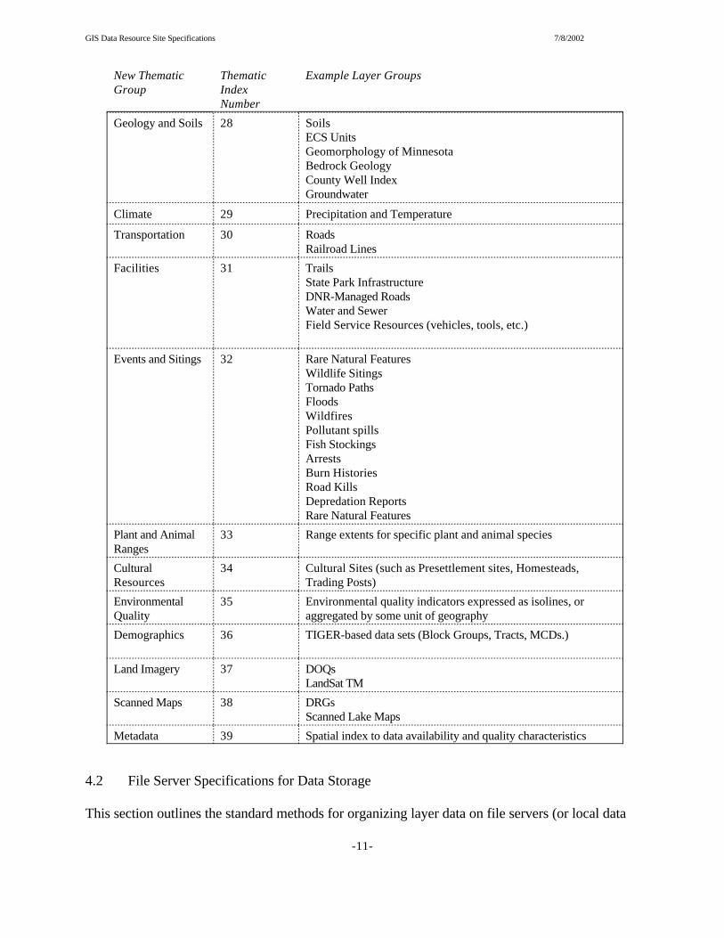
GIS Data Resource Site Specifications 7/8/2002
New ThematicGroup
ThematicIndexNumber
Example Layer Groups
-11-
Geology and Soils 28 SoilsECS UnitsGeomorphology of MinnesotaBedrock GeologyCounty Well IndexGroundwater
Climate 29 Precipitation and Temperature
Transportation 30 RoadsRailroad Lines
Facilities 31 TrailsState Park InfrastructureDNR-Managed RoadsWater and SewerField Service Resources (vehicles, tools, etc.)
Events and Sitings
32 Rare Natural FeaturesWildlife SitingsTornado PathsFloodsWildfiresPollutant spillsFish StockingsArrestsBurn HistoriesRoad KillsDepredation ReportsRare Natural Features
Plant and AnimalRanges
33 Range extents for specific plant and animal species
CulturalResources
34 Cultural Sites (such as Presettlement sites, Homesteads,Trading Posts)
EnvironmentalQuality
35 Environmental quality indicators expressed as isolines, oraggregated by some unit of geography
Demographics 36 TIGER-based data sets (Block Groups, Tracts, MCDs.)
Land Imagery 37 DOQsLandSat TM
Scanned Maps 38 DRGsScanned Lake Maps
Metadata 39 Spatial index to data availability and quality characteristics
4.2 File Server Specifications for Data Storage
This section outlines the standard methods for organizing layer data on file servers (or local data

GIS Data Resource Site Specifications 7/8/2002
-12-
drs
Business_unit_ID1 Business_unit_ID2 Business_unit_ID-Ngeneral
Tile scheme 1 Tile scheme 2 Tile scheme N
Tile 2Tile 1 Tile 3Tile N
Layer 1Layer 2Layer 3 gen fsh wat
county state q024k
stlo lake cook kooc
Figure 2: File Server Directory Standard:General Case and Example Implementation(General Case)
(ExampleImplementation)
Layer 1Layer 2Layer 3
prk
state
mn
Layer 4Layer 5Layer 6
Data
data
ancillary
ancillary
drs
stores for stand-alone application environments). Structural directory hierarchies and namingstandards are very critical in these types of environments, in that they form the basis for machine-based data access processes. These include: 1) Data file server directory hierarchy andassociated naming standards, and 2) ARC/INFO librarian implementations and associatedstandards. Each is treated in separate subsections below.
4.2.1 File Server Directory Hierarchy
Data stored on resource sites will exist within a strict directory hierarchy. All resources sites willhave a single root location on the file system. Subdirectories may be physically present or linkedlocations. An overview of the structure is provided in Figure 2.

GIS Data Resource Site Specifications 7/8/2002
-13-
The directory structure reflects a geographic organization scheme where data sets are organizedinto defined spatial extents. This basic approach is much the same as the current Core Databaseimplementation. There are three principal reasons to retain this configuration: 1) ARC/INFOLibrarian data structures require it, 2) the DNR user base has grown accustomed to it, and 3) DNRstaff continue to operate within a geographic, or “place’ context.
The only real structural difference between this approach and the existing Core Database approachis the introduction of a business unit tier between the tiling scheme level and the data “type” level . The reason for this addition is two-fold. First, the derived product paradigm existing at the heartof the Revised Core Database Architecture will result in significant expansion in the number oflayers administered on the various sites. This extra tier will help to reduce the total number offiles in some directories, preventing the performance impacts associated with large numbers offiles in single directories. The second reason for the addition is the need to isolate subtly differentdata layers from each other, a condition that will likely arise as data are tailored to business-specific applications. These business products will be isolated within specific portions of the filesystem. All applications will draw upon a general source for some base level data (counties,regions, roads, etc.).
Each of the various levels in the scheme have their own standards associated with them. These aredescribed in their own subsections. The reader may note that the first two levels of the hierarchywere describe in Section 3.1.
4.2.1.1 Business Unit ID Specifications
Business Unit ID’s are text strings representing DNR administrative units that are used to segregateportions of file systems below the Resource Type level in the Data Resource Site hierarchy. Assigning specific portions of the file system to business units will help to encapsulate data for usein applications.
Business Unit ID’s are assigned to the Section level within DNR Divisions, and a level for DNRBureaus. The domain of the ID’s is as follows:
Business Unit ID Business Unit Name
com Commissioner’s Office
wld Division of Wildlife
fsh Division of Fisheries
eco Division of Ecological Services
enf Enforcement
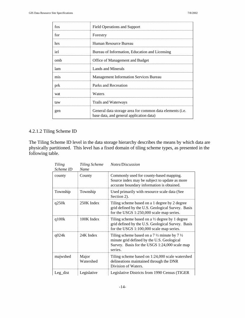
GIS Data Resource Site Specifications 7/8/2002
-14-
fos Field Operations and Support
for Forestry
hrs Human Resource Bureau
iel Bureau of Information, Education and Licensing
omb Office of Management and Budget
lam Lands and Minerals
mis Management Information Services Bureau
prk Parks and Recreation
wat Waters
taw Trails and Waterways
gen General data storage area for common data elements (i.e.base data, and general application data)
4.2.1.2 Tiling Scheme ID
The Tiling Scheme ID level in the data storage hierarchy describes the means by which data arephysically partitioned. This level has a fixed domain of tiling scheme types, as presented in thefollowing table.
TilingScheme ID
Tiling SchemeName
Notes/Discussion
county County Commonly used for county-based mapping. Source index may be subject to update as moreaccurate boundary information is obtained.
Township Township Used primarily with resource scale data (SeeSection 2).
q250k 250K Index Tiling scheme based on a 1 degree by 2 degreegrid defined by the U.S. Geological Survey. Basisfor the USGS 1:250,000 scale map series.
q100k 100K Index Tiling scheme based on a ½ degree by 1 degreegrid defined by the U.S. Geological Survey. Basisfor the USGS 1:100,000 scale map series.
q024k 24K Index Tiling scheme based on a 7 ½ minute by 7 ½minute grid defined by the U.S. GeologicalSurvey. Basis for the USGS 1:24,000 scale mapseries.
majwshed MajorWatershed
Tiling scheme based on 1:24,000 scale watersheddelineations maintained through the DNRDivision of Waters.
Leg_dist Legislative Legislative Districts from 1990 Census (TIGER
GIS Data Resource Site Specifications 7/8/2002
TilingScheme ID
Tiling SchemeName
Notes/Discussion
-15-
District data)
region DNR Region DNR Regions based on a combination of thestandard County coverage and selected roadfeatures
ecs_sub EcologicalClassificationSystemSubsection
ECS Subsections from master core version.
mndotms MnDOTHighway MapSheet
County and sub-county tiling schemeinstitutionalized by the Minnesota DOT TrunkHighway map series.
state Statewide Statewide data extent
forarea Division ofForestry Area
Division of Forestry administrative areas
dowlknum DOW Basin Basin delineation extents developed byEcological Services Lake Mapping program. Mayinclude multiple shapes per tile
4.2.1.3 Tile Ids
Each tiling scheme list above has a specific domain associated with it. These are describe in aseries of subsections below.
4.2.1.3.1 County Tile Identifiers
Tile Name Name ofCounty
aitk Aitkin
anok Anoka
beck Becker
belt Beltrami
bent Benton
bigs Big Stone
blue Blue Earth
brow Brown
carl Carlton
carv Carver
cass Cass
chip Chippewa
chis Chisago
clay Clay
clea Clearwater
cook Cook
cott Cottonwood
crow Crow Wing
dako Dakota
dodg Dodge
doug Douglas
fari Faribault
fill Fillmore
free Freeborn
good Goodhue
gran Grant
henn Hennepin
hous Houston
hubb Hubbard
isan Isanti
itas Itasca
jack Jackson
kana Kanabec
kand Kandiyohi
kitt Kittson
kooc Koochiching
lacq Lac Qui Parle
lake Lake
lotw Lake of theWoods
lesu Le Sueur
linc Lincoln
lyon Lyon
mcle McLeod
mahn Mahnomen
mars Marshall

GIS Data Resource Site Specifications 7/8/2002
Tile Name Name ofCounty
-16-
mart Martin
meek Meeker
mill Mille Lacs
morr Morrison
mowe Mower
murr Murray
nico Nicollet
nobl Nobles
norm Norman
olms Olmsted
otte Otter Tail
penn Pennington
pine Pine
pipe Pipestone
polk Polk
pope Pope
rams Ramsey
redl Red Lake
redw Redwood
renv Renville
rice Rice
rock Rock
rose Roseau
stlo St. Louis
scot Scott
sher Sherburne
sibl Sibley
stea Stearns
stee Steele
stev Stevens
swif Swift
todd Todd
trav Traverse
waba Wabasha
wade Wadena
wase Waseca
wash Washington
wato Watonwan
wilk Wilkin
wino Winona
wrig Wright
yell YellowMedicine
GIS Data Resource Site Specifications 7/8/2002
-17-
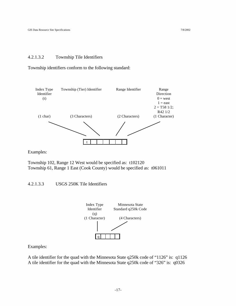
4.2.1.3.2 Township Tile Identifiers
Township identifiers conform to the following standard:
t
Index TypeIdentifier
(t)
Township (Tier) Identifier Range Identifier RangeDirection0 = west1 = east
2 = T58 1/2;R42 1/2
(1 char) (3 Characters) (2 Characters) (1 Character)
Examples:
Township 102, Range 12 West would be specified as: t102120Township 61, Range 1 East (Cook County) would be specified as: t061011
4.2.1.3.3 USGS 250K Tile Identifiers
Index TypeIdentifier
(q)
Minnesota StateStandard q250k Code
(1 Character) (4 Characters)
q
Examples:
A tile identifier for the quad with the Minnesota State q250k code of “1126” is: q1126A tile identifier for the quad with the Minnesota State q250k code of “326” is: q0326

GIS Data Resource Site Specifications 7/8/2002
-18-
4.2.1.3.4 USGS 100K Tile Identifiers
100K tile identifiers conform to the following standard:
Index TypeIdentifier
(q)
Minnesota StateStandard q100k Code
(1 Character) (4 Characters)
q
Examples:
A tile identifier for the quad with the Minnesota State q100k code of “2342” is: q2342A tile identifier for the quad with the Minnesota State q100k code of “318” is: q0318
4.2.1.3.5 USGS 24K Tile Identifiers
24K tile identifiers conform to the following standard:
Index TypeIdentifier
(q)
Minnesota StateStandard q024k Code
(1 Character) (4 Characters)
q
Examples:
A tile identifier for the quad with the Minnesota State q024k code of “1011” is: q1011A tile identifier for the quad with the Minnesota State q024k code of “118” is: q0118

GIS Data Resource Site Specifications 7/8/2002
-19-
4.2.1.3.6 Major Watersheds
Major watershed tile identifiers conform to the following standard:
Index TypeIdentifier
(maj)
Minnesota StateStandard Major
Watershed designator(3 Character) (2 Characters)
m a j
Examples:
A tile identifier for the Minnesota Major Watershed code of “38” is: maj38A tile identifier for the Minnesota Major Watershed code of “1” is: maj01
4.2.1.3.7 Legislative District
Legislative district tile identifiers conform to the following standard:
Index TypeIdentifier
(leg)
Minnesota StateRepresentative District
Identifier(3 Character) (3 Characters)
l e g
Examples:
A tile identifier for the Minnesota Representative District “1a” is: leg01aA tile identifier for the Minnesota Representative District “10a” is: leg10a
GIS Data Resource Site Specifications 7/8/2002
-20-
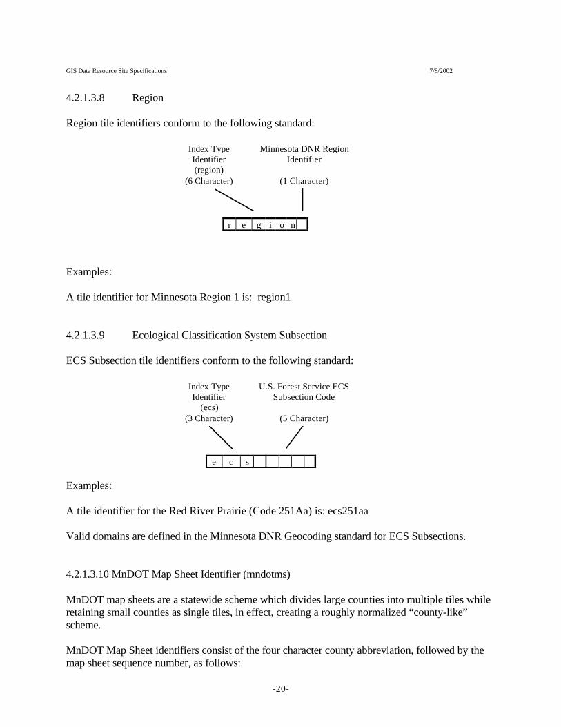
4.2.1.3.8 Region
Region tile identifiers conform to the following standard:
Index TypeIdentifier(region)
Minnesota DNR RegionIdentifier
(6 Character) (1 Character)
r e g i o n
Examples:
A tile identifier for Minnesota Region 1 is: region1
4.2.1.3.9 Ecological Classification System Subsection
ECS Subsection tile identifiers conform to the following standard:
Index TypeIdentifier
(ecs)
U.S. Forest Service ECSSubsection Code
(3 Character) (5 Character)
e c s
Examples:
A tile identifier for the Red River Prairie (Code 251Aa) is: ecs251aa
Valid domains are defined in the Minnesota DNR Geocoding standard for ECS Subsections.
4.2.1.3.10 MnDOT Map Sheet Identifier (mndotms)
MnDOT map sheets are a statewide scheme which divides large counties into multiple tiles whileretaining small counties as single tiles, in effect, creating a roughly normalized “county-like”scheme.
MnDOT Map Sheet identifiers consist of the four character county abbreviation, followed by themap sheet sequence number, as follows:

GIS Data Resource Site Specifications 7/8/2002
-21-
4.2.1.3.11 State
The state tiling scheme simply fits the 2 character postal code for each state in lower case format,and includes: mn, wi, nd, sd, ia
4.2.1.3.12 Forarea
This tiling scheme exists to support data tiled by Division of Forestry administrative area.
Forarea tile identifiers conform to the following standard:
Domain
values for this element are as follows:
for111 Bemidji Areafor116 Bagley Areafor117 Blackduck Areafor121 Warroad Areafor123 Wannaska Areafor131 Baudette Areafor161 Park Rapids Area

GIS Data Resource Site Specifications 7/8/2002
-22-
for162 Alexandria Areafor163 Detroit Lakes Areafor221 Deer River Areafor222 Effie Areafor234 Hibbing Areafor241 Orr Areafor245 Tower Areafor251 Cloquet Areafor253 Two Harbors Areafor255 Grand Marais Areafor261 Littlefork Areafor311 Brainerd Areafor311 Brainerd Areafor312 Little Falls Areafor312 Little Falls Areafor312 Little Falls Areafor321 Backus Areafor323 Pequot Lakes Areafor331 Hill City Areafor334 Aitkin Areafor342 Moose Lake Areafor344 Hinckley Areafor351 Cambridge Areafor353 St. Cloud Areafor442 Mankato Areafor443 New Ulm Areafor444 Willmar Areafor531 Lewiston Areafor532 Caledonia Areafor533 Preston Areafor534 Lake City Areafor541 Rochester Areafor545 Faribault Areafor611 North Metro Areafor612 East Metro Areafor613 West Metro Areafor999 Red Lake Reservation
4.2.1.3.12 dowlknum
This tiling scheme exists to support lake survey developed by the Division of Ecological ServicesLake Mapping program.
Dowlknum tile identifiers conform to the following standard:

GIS Data Resource Site Specifications 7/8/2002
-23-
4.2.1.4 Layer Names
The Layer Names level in the data storage hierarchy uses the layer naming conventions outlined inSection 3 of this document. Shapefiles and image file types use the naming standard directly byadding the extensions appropriate for their file type (e.g., .shp, or .tif). ARC/INFO Librarianlayers represent a special case, and are treated in the following section.
4.2.2 ARC/INFO Librarian Implementations
A key LIBRARIAN implementation issue relates to the placement of the library database directoryon the file system. These will be placed in a standard, consolidated location under the metadatasection of the Data Resource Site file system. The rationale for separating these metadata from thetile level of the hierarchy (where they reside in the old Core Database schema), is to maintain thepurity of the data stores. At present, all applications that interact with the tile level of thedirectory hierarchy must account for, and ignore the LIBRARIAN “database” directory. It wouldbe preferable to remove this exception from that environment. Consolidating these directories alsoallows system administration staff to reference all libraries with a single environment variable. The general LIBRARIAN schema is depicted graphically in Figure 3.

GIS Data Resource Site Specifications 7/8/2002
-24-
<Data Resource Site>
General
County
Anok Beck Belt
Data Metadata
Librarian
<Databasedir 1>
<Databasedir 2>
Librariandefinitionenvironment
Librariandefinitionenvironment
Figure 3: LibrarianConfiguration on a StandardData Resource Site
ArclibDrslib
Tables Tables
Specifications are also required for library names and LIBRARIAN database directory names (at../metadata/librarian locations in Figure 3). Library names will conform to the followingspecification:
<business unit id>_<tiling scheme id>
Examples:fsh_county, gen_q024k
Librarian database directory names will follow the identical name specification.
The <Data Resource Site>/metadata/librarian location also includes instances of the libraries fileregistry (normally found under $ARCHOME/tables). The drslib directory contains an infodirectory named “tables” which stores a table named LIBRARIES which is a registry of librarianinstances available on the Data Resource Site. This is a LIBRARIES registry instance which isbuilt around the site. Desktop applications should reference this location as the user $ARCHOMElocation (ARCHOME=<Data Resource Site>/metadata/librarian/drslib). The arclib location is asymbolic link to the UNIX-based ARC/INFO location, and should not (or may not) be referencedby regular desktop applications.
4.2.3 Image Catalogs
Like librarian metafiles, image catalogs are stored within the metadata location. In this case, they
GIS Data Resource Site Specifications 7/8/2002
3 A spatial column is a table column that uniquely identifies a feature. In tiled data sets, it provides theability to “knit” together spatial objects that are split by tile boundaries
-25-
are all stored within a single directory location:
<Data Resource Site>/metadata/image_cats/info
Image catalogs are named for the layer they reference. Since these are INFO files, they are storedin ALL CAPS. Examples include:
MAP_DRG024IM3IMG_DOQ03IM4
4.3 Database Server Specifications
Database servers within the Revised Core environment only exist at the Central Office. Therefore,no site-specific implementation standards are required, except in reference to the data provided bythat environment. The primary distinction to be made is between data served by SDE databaseserver technology and that provided by native Oracle. These are treated in separate subsections.
4.3.1 Data Retrieved from SDE Database Servers {NOTE: this section not deployed at thistime}
Five information elements are needed to retrieve data from SDE. There are: 1) server name, 2)instance name, 3) layer name, 4) user name, and 5) password. The latter two elements arediscussed in Appendix 2 (System Security Configuration) and Section 5.1.3 of this document. Server names are controlled through the system-wide data dictionary. Instance names willconform to the following specification:
sde_<server type>_<business unit ID>
Examples:sde_ora_eco (An SDE for Oracle server instance supporting Ecological Services)sde_cov_gen (An SDE for Coverages server instance providing general data access)
Layer names are controlled by the SDE server and will follow the specifications provided inSection 3.1 of this document, except that the server requires a second term be appended to thelayer name stating the “spatial column”3 of the feature class being presented. Therefore, SDElayer names will conform to the following format:
<dnr layer name>.<spatial column>
Examples:lake_pwipy3.shape#wet_circ39py3.cir39py3#

GIS Data Resource Site Specifications 7/8/2002
-26-
<Data Resource Site>
Metadata
Librarian
<Databasedir 1>
<Databasedir 2>
Librariandefinitionenvironment
Librariandefinitionenvironment
Data_def Narrative
Figure 4: Data Resource SiteMetadata Support Directory Tree
Data_layer_defData_store_defData_table_def
{not defined atthis time}
Image_cats
Info
Drslib Arclib
Tables Tables
4.3.2 Data Retrieved from Oracle Database Servers {NOTE: this section not deployed at thistime}
DNR’s traditional tabular database environment is not supported by data structuring standards (fortable names, view names, server instance names). However, tabular information is an importantpart of the application environment supported by data resource sites. Tabular data access will bemanaged through the use of Windows NT ODBC protocols, and will therefore require some levelof client configuration and setup (driver installation, ODBC source registration). Tabular dataaccess requires several information elements, including: 1) ODBC source, 2) User name, 3)Password, and 4) table name. <No specific standards have been developed at this time that wouldaffect any of these elements. This part of the specification is still under development.>
<metadata structures needed to support table access are not currently developed. The Oracle datadictionary will likely provide this information>
5.0 System Level Metadata
System level metadata is the Data Resource Site center of activity. This section of the ResourceSite file system contains a variety of descriptive information that instructs applications, andfacilitates site administration. It provides a roadmap of the resources available through the site.
Three types of metadata elements are described in this section of the file system, including: 1) datadefinition, 2) narrative metadata, and 3) ARC/INFO LIBRARIAN references. The directorystructure that supports these data elements is described in Figure 4 and discussed below.

GIS Data Resource Site Specifications 7/8/2002
-27-
5.1 Data Definition
The Data Definition section of the Data Resource Site exists to define the suite of data that areavailable to users on a particular site and the methods needed to access the data in the desktopenvironment. Various registry types are described below which store information about particulardata types.
5.1.1 Data Layer Registry
The Data Layer Registry is a comprehensive list of the GIS data layers available on a DataResource Site. It’s physical name is “data_layer_def”. It is an ASCII format, comma delimitedfile that lists a standard set of elements that define basic data layer characteristics. It uses thekeyword “null” as a placeholder for null elements, and single quote character “ ‘ “ as a commentline indicator in the first position of the record.
The formal record layout is as follows:
[layer_desc],[DNR_Unit],[tiling_scheme],[product_type],[resource_description],[vendor_object_type],[server],[instance],[derived product id], [thematic classid]
• layer_desc is the so-called “long name” of the layer describe in Section 4.1.2 of thisdocument
• DNR_unit is the DNR Business Unit ID described in Section 4.2.11 of this document• tiling_scheme is the standard tiling scheme ID described in Section 4.2.1.2 of this
document• product_type is Data Dictionary element that describes the physical format in which the
data are made available. It is a numeric code with the following domain:
1 - coverage2 - shapefile3 - sde4 - geodatabase5 - region6 - grid7 - tin8 - route9 - tif10 - jpeg11 - oracle12 - info13 - dbase14 - eppl

GIS Data Resource Site Specifications 7/8/2002
-28-
15 - db216 - text17 - photograph18 - mrsid19 - erdas_imagine20 - erdas_gis21 - ARC/INFO librarian
• resource_description is the 13 character layer name described in Section 4.1.2 of thisdocument
• vendor_object_type is the feature class of the data. It’s domain as of this writing is:
polygonpointlineraster
• server is the name of the database server used to serve SDE data types• instance is either: 1) the name of the SDE instance used to serve the data, or 2) the name
of the librarian database that the data are stored within. SDE instances conform to therules described in Section 4.3.1 of this document. Librarian database instances conformto the rules described in Section 4.2.2.
• derived product id is the unique derived product identifier, composed in the datadictionary of the MetaProductID, ProductTypeID, and FeatureClassID columns. This isused to query the Data Dictionary using the JSP-based intranet metadata reports.
• thematic class id is the numeric theme class identifier (Section 4.1.4)
Data Layer Registry records example:
Hybrid County Boundaries,gen,state,2,bdry_counpy3,polygon,null,null,220000030301,2224K Quadrangle Index,gen,state,2,indx_q024kpy4,polygon,null,null,2100000202011,21
5.1.2 Data Table Registry {NOTE: this section not deployed at this time}
The Data Table Registry functions much the same way as the Data Layer Registry, except that itprovides a comprehensive listing of available tables. Within DNR’s enterprise environment, allregistered data tables come from centralized database servers.
The Data Table Registry’s physical name is “data_table_def”. It is an ASCII format, commadelimited file that lists a standard set of elements that define basic data table characteristics. Ituses the keyword “null” as a placeholder for null elements, and single quote character “ ‘ “ as acomment line indicator in the first position of the record.
The formal record layout is as follows:
<not defined yet>

GIS Data Resource Site Specifications 7/8/2002
-29-
5.1.3 Database Source Registry
The Database Source Registry provides user name and password information for centralized dataserver access. It’s physical name is “data_store_def”. It is an ASCII format, comma delimitedfile that lists a standard set of elements that define basic data table characteristics. It uses thesingle quote character “ ‘ “ as a comment line indicator in the first position of the record. It isrelated to the Data Table and Data Layer Registries by the “instance” element in each table, whichserves as the primary key in the table.
The formal record layout is as follows:
[instance],[server],[user name],[password]
Example record:
sde_ora_gen,pinchot,reg2_user,sde
5.2 Narrative Metadata {This section has been withdrawn}
5.3 ARC/INFO Librarian References
The ARC/INFO Librarian Reference Environment is described in Section 4.2.2 and will not berepeated here.
6.0 Application Components
Data Resource Sites house a variety of application software, including programs and relatedsupporting data, and software extensions (i.e. for ARCVIEW). This part of the filesystem supportsboth UNIX and NT client environments. The general layout of this part of the Data Resource Sitefilesystem is presented below.

GIS Data Resource Site Specifications 7/8/2002
-30-
<Data Resource Site>
Apps
Arcview
Extensions Theme catalogs
Gen_app_support
Librarian_indexesImage_cats
<other apps>
Look_up_tablesTile_lists
The Application section of a Data Resource Site consolidates fileserver-based applicationsoftware into a single location, facilitating distribution of updates, enhancements, and newadditions. Common program support elements are also consolidated under a gen_app_supportlocation.
Gen_app_support includes sets of generic, static metadata that support a variety of applicationfunctions. As such, they are part of the DRS specification, and require some level of description. The following elements are described in separate subsections below: 1) drs_theme_list, 2)lib_tmplt, 3) librarian_indexes, 4) look_up_tables, 5) search_indexes, and 6) tile_lists.
6.1 drs_theme_list
The drs_theme_list is a single comma-delimited ASCII-formatted text file that cross referencestheme categories with theme numbers. It is used by applications that need to associated themenumbers ( see Section 4.1.4) from the DRS data_layer_def file with textual thematic classdescriptions. A sample set of records is as follows:
21,Control22,Administrative Features23,Public Land Survey24,Ownership
6.2 lib_tmplt
The lib_tmpt section includes a set of templates that are used to create librarian “database”directories. There is one template per tiling scheme. Each template is a system directory

GIS Data Resource Site Specifications 7/8/2002
-31-
containing a librarian index coverage and INFO workspaces and files to hold layer and access(permissions) information. These are used during the site update process to build new librariandata structures that reflect the content of each individual DRS.
6.3 librarian_indexes
The librarian_indexes are the master tile index coverages. These are the ARC/INFO indexcoverage sources for the lib_tmplt location and also are used for status file generation inQuickThemes.
6.4 look_up_tables
look_up_tables contains an INFO workspace that includes a set of files that cross-referencescommon attribute codes with their meanings. These are added to support applications on an on-going basis. At the time of this writing, eight look-up tables are included here:
QQ024K.LUTCOUNTY.LUTQ024K.LUTQ100K.LUTMAJWSHED.LUTQ250K.LUTREGION.LUTdowlknum.lut
These tables follow the format:
COLUMN ITEM NAME WIDTH OUTPUT TYPE N.DEC ALTERNATE NAME INDEXED? 1 TILE-NAME 12 12 C - - 13 LONG-NAME 40 40 C - -
6.5 search_indexes
search_indexes contains an INFO directory, which in turn contains a set of files that cross list tilesagainst the county tiling scheme. Stated another way, these are lists of tiles paired with countytiles that they overlap. These files are used to determine which tiles in a particular tiling schemeintersect particular county areas. They are essentially the tablular product of an intersectionoverlay between a particular tiling scheme and the county scheme. They are used in the site updateprocess to determine which tiles of a scheme are needed to support a particular area of interest(AOI) expressed in county extents.
A search index is named for the tiling scheme with the string “_XRF” appended to it (e.g.Q100K_XRF). The conform to the following format:
COLUMN ITEM NAME WIDTH OUTPUT TYPE N.DEC ALTERNATE NAME INDEXED? 1 CASE# 4 5 B - - 5 FREQUENCY 4 5 B - - 9 COUNTY 32 32 C - - 41 <tile Scheme Name> 32 32 C - -

GIS Data Resource Site Specifications 7/8/2002
-32-
An example set of records are:
CASE# = 273FREQUENCY = 1COUNTY = steaQ100K = q3518 274CASE# = 274FREQUENCY = 1COUNTY = steaQ100K = q3526 275CASE# = 275FREQUENCY = 1COUNTY = steeQ100K = q4334 276CASE# = 276FREQUENCY = 1COUNTY = steeQ100K = q4734 277CASE# = 277FREQUENCY = 1COUNTY = stevQ100K = q3110
6.6 tile_lists
The tile_lists location contains the master lists of available tiles within each tiling scheme. Theseare ASCII formatted text files, one file per tiling scheme that list the available tiles in lower casestrings. Tile list names follow the format:
mast_<tile scheme name>_list
For example:
mast_q100k_list
example contents (for q100k) are as follows:
q0318q0326q0702q0710q0718q0726q0734q0742q1102q1110q1118q1126

GIS Data Resource Site Specifications 7/8/2002
-33-
...
7.0 Process
Data Resource Sites will be the subject of many automated processes to facilitate maintenance andaccess. The “process” subdirectory below the resource site root location provides a place toexecute programs, write out log files, and create temporary data. The principle reason for creatingthis location is to keep that portion of the file system used to store data completely clean. Therehas been a tendency to introduce temporary files, programs, and backup directories into Core datalocations. This potentially compromises the integrity of applications which move data betweenlocations, report data availability and status, and determine data volumes. Consolidatingtemporary files in a single location also facilitates site clean-up. It should be noted that data thatare accessed regularly by applications should be stored in the Application section of the site.
8.0 Wrap-up
The Data Resource Site concept reflects a philosophy of distributed data access which will likelybe rendered obsolete within a four to six year period. The first step in this process will be theelimination of most of the metadata elements from the sites in favor of centralized access of thesedescriptive components. Data resources themselves will also migrate to centralized locationsthrough time (from file servers to database server environments). With a solid distributedarchitecture, this migration from local to remote access (distributed to centralized) can beaccomplished in a gradual, orderly fashion when improvements in network infrastructure(bandwidth) become available.

GIS Data Resource Site Specifications 7/8/2002
-34-
Appendix 1: Operating EnvironmentBaselines

GIS Data Resource Site Specifications 7/8/2002
-35-
Minnesota DNR Revised Core Database Architecture
Access Site Specification Notes
1.11 Access Site Specification Elements
• Metastore specification (including data model and physical format)• Layer naming • File system organization• Supported data types
2.Operating Environment Description2.1 Operating systems
2.1.1 Windows NT/95/98/20002.1.2 Solaris 7.X2.1.3 AS/400
2.2 Hardware2.2.1 Sun Microsystems Workstations/Servers2.2.2 Intel workstations
• 300 MHz Pentium• 64 Mb RAM• 4 Mb graphics card• Microsoft-compatible CD-ROM reader
2.3 Client application environment2.3.1 ARCVIEW (Windows/UNIX)2.3.2 VB-Map Objects2.3.3 Workstation ARC/INFO (UNIX/Windows)2.3.4 ARC/INFO 8 Desktop
2.4 Database administration environment2.4.1 Workstation ARC/INFO (UNIX)2.4.2 Oracle 8i2.4.3 UDB2.4.4 SDE2.4.5 pkzip-unzip compression (Windows/UNIX)
2.5 Application Server Environment2.5.1 MapServer2.5.2 ARC IMS
3.Operational Requirements3.1 Integration with data dictionary3.2 Optimize mirroring/site update processes3.3 Optimize for facilitated desktop access3.4 Suitability for ad hoc desktop access (file system browsing, appearance in add themes view window
Access Site Specification Notes (cont.)
4.Filesystem Storage Standards4.1 Layer naming elements (potential)-filesystem, librarian, and SDE types
• Layer abbreviation/description• Feature class• Scale class• Native tiling scheme

GIS Data Resource Site Specifications 7/8/2002
-36-
4.2 Directory organization (issues and potential approaches)• Thematic/spatial hybrid• Top level thematic organization (library) or (possibly) top-level discipline organization
(fisheries, forestry, etc); supplemented with a single general access area• Sub-levels oriented around geography (core-like tiling scheme ID) with tile sub-directories
4.3 Tile specifications (should remain intact from current core specs, except possibly township, which hasalways been anomalous).

GIS Data Resource Site Specifications 7/8/2002
-37-