gis standards for lawa projects · all files and documents submitted to lawa must be accompanied by...
TRANSCRIPT

GIS Standards for LAWA projects
GIS Standards for LAWA Projects

GIS Standards for LAWA projects
Document History
revision letter release date major changes approved by
A September 2012 new version of standards
B June 2014 General Review
C August 2014 IMTG GIS Support Services Division

GIS Standards for LAWA projects
GIS_Standards_August_2014.docx revision letter C revision date August 2014 © x-Spatial LLC, 2014 status: Published page i
Table of Contents
About this book ...................................................................................................................................... 1
Relation to existing standards ......................................................................................................... 1
Who should read this book ............................................................................................................. 1
How this book is organized ............................................................................................................. 1
Related documents ......................................................................................................................... 2
Abbreviations .................................................................................................................................. 2
Introduction ............................................................................................................................................ 3
Standards in use at LAWA .................................................................................................................... 4
LAWA Standards............................................................................................................................. 4
National and International standards .............................................................................................. 5
Compliance ..................................................................................................................................... 6
Request of Variance ....................................................................................................................... 6
Data organization ................................................................................................................................... 7
Implementing SDSFIE at LAWA ..................................................................................................... 8
Entity set ......................................................................................................................................... 9
Entity classes ................................................................................................................................ 10
Entity types .................................................................................................................................... 12
Discriminators for entity types .............................................................................................. 18
Attributes for entity types ...................................................................................................... 20
Entity attributes ............................................................................................................................. 23
Common metadata fields ..................................................................................................... 23
Specific metadata fields ....................................................................................................... 28
Entity naming conventions ............................................................................................................ 35
Attribute tables .............................................................................................................................. 36
Domain values .............................................................................................................................. 39
LAWA SDSFIE data dictionaries ......................................................................................................... 40
File names ............................................................................................................................................. 42
Translating CAD layers to GIS layers ................................................................................................ 44

GIS Standards for LAWA projects
GIS_Standards_August_2014.docx revision letter C revision date August 2014 © x-Spatial LLC, 2014 status: Published page ii
THIS PAGE IS INTENTIONALLY LEFT BLANK

GIS Standards for LAWA projects
GIS_Standards_August_2014.docx revision letter C revision date August 2014 © x-Spatial LLC, 2014 status: Published page 1 of 45
About this book
This document establishes the data standards for submitting Geographic Information System (GIS) data to LAWA and for organizing GIS data within the LAWA geospatial data repository. These standards help ensure efficient exchange of digital information between LAWA and all authorized users of LAWA GIS data.
Relation to existing standards
This LAWA GIS standard is directly based on the ANSI Spatial Data Standard for Facilities Infrastructure and Environment (SDSFIE), Release 2.60. SDSFIE is developed and maintained by the Federal CADD/GIS Technology Center, Vicksburg, MS.
This document presents the most important aspects of SDSFIE as it applies to LAWA. The LAWA GIS standards are based on SDSFIE, extended in certain areas to handle specific information relevant to LAWA.
Who should read this book
This book is intended for all LAWA employees, consultants, and contractors, especially for members of their staff who prepare GIS data; and for local, state, and federal government agencies including city, police, state DOT, FAA, and TSA.
How this book is organized
This book contains the following sections:
Introduction
Why these standards are important, what they are based on, how to suggest extensions or changes, and how compliance is assessed.
Standards in use at LAWA
Overview of LAWA specific standards and International standards
Data organization
The five elements of the classification hierarchy: entity sets, entity classes, entity types, attributes, and attribute domains
LAWA SDSFDIE data dictionaries
The two major reference sources to be used when applying the LAWA GIS standards.
File names
How filenames are to be constructed, based on the classification hierarchy.
Translating CAD layers to GIS layers
Mapping layers in the LAWA CAD Layering Standard to the GIS layering standard

GIS Standards for LAWA projects
GIS_Standards_August_2014.docx revision letter C revision date August 2014 © x-Spatial LLC, 2014 status: Published page 2 of 45
Related documents
CAD, BIM, Meta Data, Survey and EDI standards along with other documentation related to these standards are available on the LAWA website. LAWA Standard Documents and Guidelines
Abbreviations
AEGIS Airport Enterprise Geographical Information System
AIA American Institute of Architects
ANSI American National Standards Institute
BIM Building Information Modeling
CAD Computer Aided Design
CPPE Capital Planning, Programming and Engineering
DDMS Drawing and Document Management System
DOT Department of Transportation
EDI Electronic Data Interchange
EPA Environmental Protection Agency
FAA Federal Aviation Authority
GIS Geographical Information System
GISSSD GIS Support Services Division
NCS National CAD Standards
LAWA Los Angeles World Airports
SDSFIE Spatial Data Standard for Facilities Infrastructure and Environment
TSA Transportation Security Administration
USACE U.S. Army Corps of Engineers
GIS Standards for LAWA projects
GIS_Standards_August_2014.docx revision letter C revision date August 2014 © x-Spatial LLC, 2014 status: Published page 3 of 45
Introduction
These standards and specifications are intended to improve data consistency and availability of information, and facilitate spatial information dissemination and sharing within LAWA throughout the entire lifecycle of the airport infrastructure.
Tools for capturing geospatial data are provided within LAWA by the AEGIS application. This application enables users to create, view, and edit geospatial datasets
Geospatial data sets, allows LAWA to share information throughout the enterprise primarily through the AEGIS system. The geospatial element sets include topographic and utility/facility data.
By using these standards, LAWA will achieve a standardized approach to spatial data management and related record document(s) that will bring many benefits to both the organization and its staff. These benefits include, but are not limited to:
consistent and more reliable data that will lead to more informed decision making
closer integration with other LAWA information systems and LAWA spatial data users
portability of staff skills
greater interoperability with organizations outside of LAWA
AllfilesanddocumentssubmittedtoLAWAmustbeaccompaniedbyatransmittalformholdingallrequiredmetadata.
Transmittalformsalongwithotherdocumentationrelatedtothesestandardsareavailable
ontheLAWAwebsite. LAWA Standard Documents and Guidelines

GIS Standards for LAWA projects
GIS_Standards_August_2014.docx revision letter C revision date August 2014 © x-Spatial LLC, 2014 status: Published page 4 of 45
Standards in use at LAWA
LAWA Standards
This section provides an overview of LAWA specific standards, plus related federal, local, and national standards. LAWA standards have been created to improve productivity and reliable information exchange through the full life-cycle of geospatial data, CAD and BIM files along with related documents.
LAWA Metadata Standards
Metadata is structured information that describes, explains, locates, or otherwise makes it easier to retrieve, use, or manage an information resource. Metadata is often called data about data or information about information.
LAWA CAD Standards
The LAWA CAD standards are based largely on the AIA CAD Layer Guidelines and the National CAD Standards (NCS), adapted where necessary to suit LAWA-specific requirements.
LAWA GIS Standards
The LAWA GIS standards are directly based on the ANSI Spatial Data Standard for Facilities Infrastructure and Environment (SDSFIE), Release 2.60, extended in certain areas to handle specific information relevant to LAWA. GIS Standards for LAWA Projects presents the most important aspects of SDSFIE as it applies to LAWA.
LAWA Survey Standards
The LAWA Survey and Remote Sensing Standards are based on requirements laid out in Airport Circulars published by the FAA, adapted where necessary to suit LAWA-specific requirements.
LAWA BIM Standards
These guidelines focus primarily on adaptation of standards for practical and efficient application of BIM, particularly at the handover (Record - As-Built) stage of a project. Based on USACE_CAD-BIM_Technology Center: version 1.1 and National BIM standard (United States): version2
LAWA EDI (Electronic Data Interchange) Standards
This Standard provides a framework for all data requests and all hard copy or electronic data submittals to or from LAWA, thus ensuring a streamlined data exchange process
Thesestandardsalongwithotherdocumentationrelatedtothesestandardsareavailable
ontheLAWAwebsite. LAWA Standard Documents and Guidelines

GIS Standards for LAWA projects
GIS_Standards_August_2014.docx revision letter C revision date August 2014 © x-Spatial LLC, 2014 status: Published page 5 of 45
National and International standards
ISO 19115 – 2: Geographic information - Metadata - Part 2
Fully endorsed by the FGDC, ISO 19115-2 has become the preferred standard for LAWA as it includes all of the elements of ISO 19115 as well as additional elements that are relevant to many geospatial data sets (raster, imagery, GPS, monitor stations, instruments, etc.).
FGDC-STD-001 June 1998
The Content Standard for Digital Geospatial Metadata (CSDGM) has been in use at LAWA for a long time, and legacy data will remain valid for many years.
SDSFIE 2.6
The overall structure of LAWA current geospatial repository is based on SDSFIE 2.6. SDSFIE organizes real world features such as runways, roads and water pipes into a hierarchical structure.

GIS Standards for LAWA projects
GIS_Standards_August_2014.docx revision letter C revision date August 2014 © x-Spatial LLC, 2014 status: Published page 6 of 45
Compliance
Having timely up to date, accurate, fully compliant data available to the LAWA community forms an integral part of planning within any project. The aim of these standards is to ensure a smooth data transfer of information into the LAWA geospatial data base and efficient data maintenance through the complete data lifecycle. Accordingly, the terms and conditions of a LAWA contract require compliance with these standards.
Failure to comply with these standards may result in organizations being back-charged for any financial costs incurred by LAWA for rectifying inconsistencies and errors
The individual or organization submitting the files is also responsible for ensuring that all links between non-graphic data and graphic data, and all relationships between database tables, shall be preserved or automatically reconstructed when data is transferred to the LAWA GIS environment.
Request of Variance
Compliance with the LAWA standards and data deliverables demands are the cornerstone of achieving trustworthy and relevant data.
Suggestions for improvements or extensions to these standards and demands are encouraged, to meet unforeseen requirements and as a way to improve effectiveness and clarify any ambiguities; any such deviation must be approved by LAWA, in advance and in writing. . Requests need to be submitted on the “Request for variance” form, this form along with other documentation related to these standards are available on the LAWA website. LAWA Standard Documents and Guidelines
SeeEDIforstandardsgoverningdatasubmittedtoLAWA,thisalongwithother
documentationrelatedtothesestandardsareavailableontheLAWAwebsite. LAWA Standard Documents and Guidelines
GIS Standards for LAWA projects
GIS_Standards_August_2014.docx revision letter C revision date August 2014 © x-Spatial LLC, 2014 status: Published page 7 of 45
Data organization
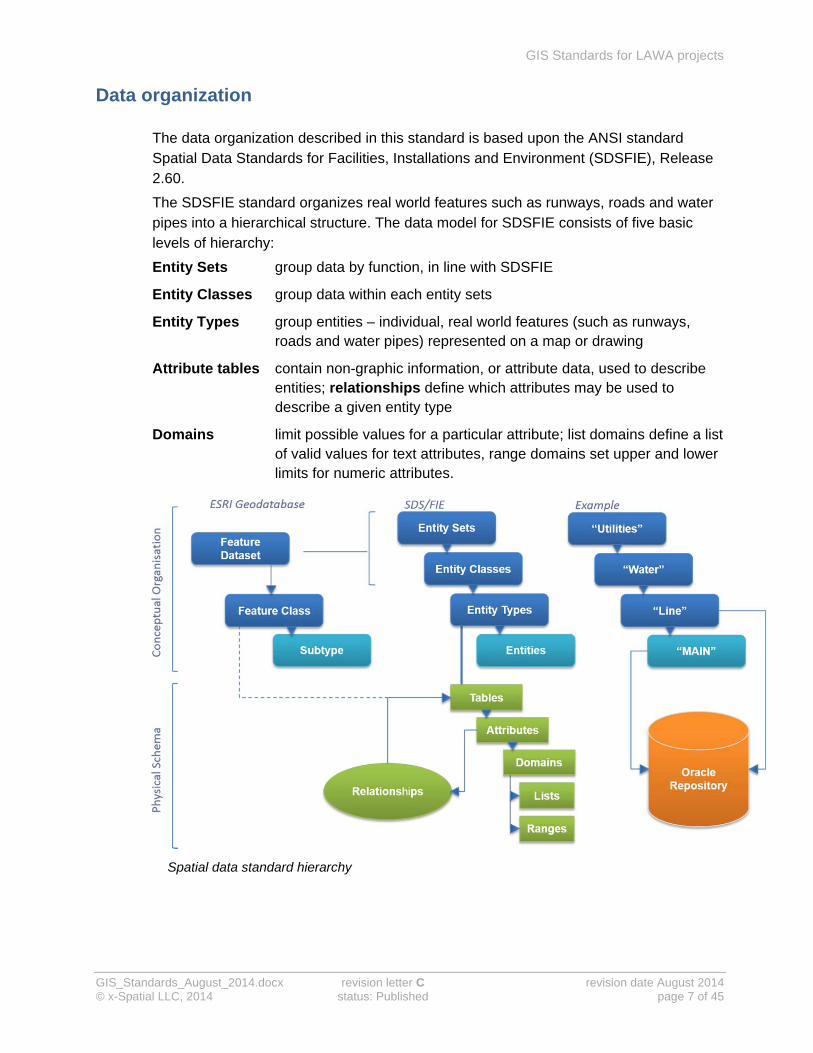
The data organization described in this standard is based upon the ANSI standard Spatial Data Standards for Facilities, Installations and Environment (SDSFIE), Release 2.60.
The SDSFIE standard organizes real world features such as runways, roads and water pipes into a hierarchical structure. The data model for SDSFIE consists of five basic levels of hierarchy:
Entity Sets group data by function, in line with SDSFIE
Entity Classes group data within each entity sets
Entity Types group entities – individual, real world features (such as runways, roads and water pipes) represented on a map or drawing
Attribute tables contain non-graphic information, or attribute data, used to describe entities; relationships define which attributes may be used to describe a given entity type
Domains limit possible values for a particular attribute; list domains define a list of valid values for text attributes, range domains set upper and lower limits for numeric attributes.
Spatial data standard hierarchy

GIS Standards for LAWA projects
GIS_Standards_August_2014.docx revision letter C revision date August 2014 © x-Spatial LLC, 2014 status: Published page 8 of 45
Implementing SDSFIE at LAWA
Every entity type at the airport, and the entities that belong to it, will have a minimal set of attributes that identify it uniquely, plus a number of other attributes that explain how it fits into the structure of entity types, entity classes and entity sets.
Attributes common to most entity types include:
datalink
A unique identifier generated by the software, and used to link a database record to a specific graphic feature.
primary key
A unique, LAWA defined identifier for each record or instance of an entity.
foreign key
Used where an entity record held in one database table refers to information held in another table (building, project, owner and so on).
discriminator
Entities within the same entity type can be distinguished by using discriminators to describe them.

GIS Standards for LAWA projects
GIS_Standards_August_2014.docx revision letter C revision date August 2014 © x-Spatial LLC, 2014 status: Published page 9 of 45
Entity set
Entity sets are the highest level of the SDSFIE data model structure and represent data organised at the project level. Each entity set corresponds to a broad, generalized theme, and contains one or more entity classes.
SDSFIE identifies 26 top-level classifications or entity sets to classify GIS data at LAWA by function. LAWA uses the entity sets that are relevant to the airport and its surroundings.
At time of publication an additional UMS entity set has been added using the AEGIS application.
Entity sets:
have a unique name, 2-character code and definition
determine the entity classes (and related tables) that may be grouped in an entity set
Entity sets (active entity sets are highlighted)
Each entity set has an entity set code and definition: see the example in the next table.
Example of entity set information
Entity set Utilities
Entity set code ut
Definition The man-made components of a system that provides a service to the public. The components of each utility system in this entity set are located outside the foundation of a structure.
GIS Standards for LAWA projects
GIS_Standards_August_2014.docx revision letter C revision date August 2014 © x-Spatial LLC, 2014 status: Published page 10 of 45
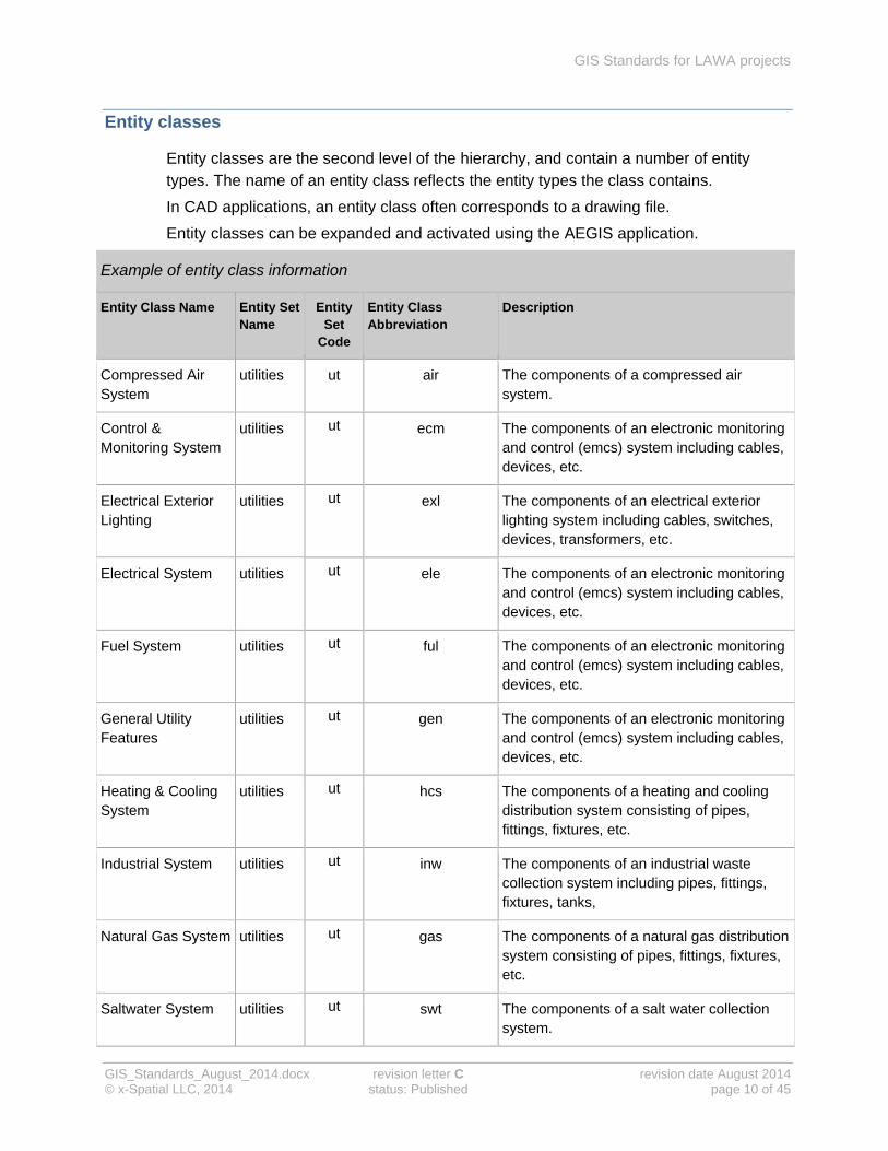
Entity classes
Entity classes are the second level of the hierarchy, and contain a number of entity types. The name of an entity class reflects the entity types the class contains.
In CAD applications, an entity class often corresponds to a drawing file.
Entity classes can be expanded and activated using the AEGIS application.
Example of entity class information
Entity Class Name Entity Set Name
Entity Set
Code
Entity Class Abbreviation
Description
Compressed Air System
utilities ut air The components of a compressed air system.
Control & Monitoring System
utilities ut ecm The components of an electronic monitoring and control (emcs) system including cables, devices, etc.
Electrical Exterior Lighting
utilities ut exl The components of an electrical exterior lighting system including cables, switches, devices, transformers, etc.
Electrical System utilities ut ele The components of an electronic monitoring and control (emcs) system including cables, devices, etc.
Fuel System utilities ut ful The components of an electronic monitoring and control (emcs) system including cables, devices, etc.
General Utility Features
utilities ut gen The components of an electronic monitoring and control (emcs) system including cables, devices, etc.
Heating & Cooling System
utilities ut hcs The components of a heating and cooling distribution system consisting of pipes, fittings, fixtures, etc.
Industrial System utilities ut inw The components of an industrial waste collection system including pipes, fittings, fixtures, tanks,
Natural Gas System utilities ut gas The components of a natural gas distribution system consisting of pipes, fittings, fixtures, etc.
Saltwater System utilities ut swt The components of a salt water collection system.

GIS Standards for LAWA projects
GIS_Standards_August_2014.docx revision letter C revision date August 2014 © x-Spatial LLC, 2014 status: Published page 11 of 45
Example of entity class information
Entity Class Name Entity Set Name
Entity Set
Code
Entity Class Abbreviation
Description
Storm System utilities ut sto The components of a storm drainage collection system including pipes, fittings, fixtures, etc.
Wastewater System utilities ut vwt The components of a wastewater collection system including pipes, fittings, fixtures, treatment plants,
Water System utilities ut wat The components of a water system including pipes, fittings, valves, fixtures, treatment plants, etc.
Example of entity class information
Entity Class Name
Water system
Entity Class Code
wat
Definition The components of a water system including pipes, valves, fixtures, treatment plants, etc.
Examples of entity classes from entity set utilities

GIS Standards for LAWA projects
GIS_Standards_August_2014.docx revision letter C revision date August 2014 © x-Spatial LLC, 2014 status: Published page 12 of 45
Entity types
An entity type is a name identifying a type of object that can be represented on a map or drawing. Each SDSFIE entity type has a text definition, a name that clearly identifies the entities it can contain, and a separate table in the database.
Entity types can be added and activated using the AEGIS application.
Every entity belonging to a particular entity type is represented on a map or drawing as an object type, using a point, a line or a polygon. Where an entity is represented as a point, an agreed symbol may also be used.
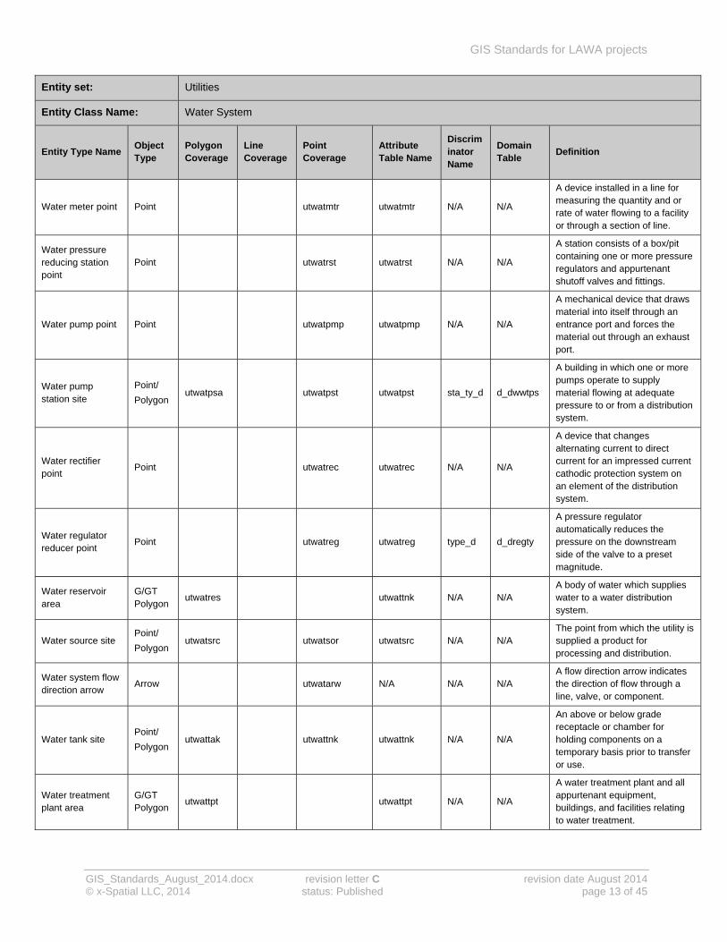
Entity set: Utilities
Entity Class Name: Water System
Entity Type Name Object Type
Polygon Coverage
Line Coverage
Point Coverage
Attribute Table Name
Discriminator Name
Domain Table
Definition
Water anode point Point utwatand utwatand N/A N/A
A material used for utility distribution systems that is electrically connected to a less electrolytically active material so that it will oxidize in the place of the less active material.
Water anode test station point
Point utwatant utwatant N/A N/A A central location where anodes are tested for performance.
Water fire connection point
Point utwatfir utwatfir con_type_d
d_dfire An apparatus which dispenses fluids for use in fire management.
Water fitting point Point utwatfit utwatfit type_d d_wgfit A fitting is an item used to connect, cap, plug or otherwise alter a pipe.
Water hydrant point
Point utwathyd utwathyd design_d
d_dhydnt An apparatus which dispenses fluids.
Water intake point Point utwatinp utwatsrc N/A N/A The location where water is allowed into the water distribution system.
Water junction point
Point utwatmh utwatmh use_d d_dwatmh
A box or small vault (usually concrete, brick, or cast iron) located below grade with above grade access where pipes intersect. The manhole also houses associated fittings, valves, meters, etc.
Water line String/
Chain utwatpip utwatpip use_d d_watpip
A pipe used to carry a substance from location to location (main line, service line, vent line, etc).
Water marker point
Point utwatmrk utgenmrk N/A N/A
A sign, concrete monument, etc. installed either directly above or immediately adjacent to underground lines, bends, fittings, etc.
GIS Standards for LAWA projects
GIS_Standards_August_2014.docx revision letter C revision date August 2014 © x-Spatial LLC, 2014 status: Published page 13 of 45
Entity set: Utilities
Entity Class Name: Water System
Entity Type Name Object Type
Polygon Coverage
Line Coverage
Point Coverage
Attribute Table Name
Discriminator Name
Domain Table
Definition
Water meter point Point utwatmtr utwatmtr N/A N/A
A device installed in a line for measuring the quantity and or rate of water flowing to a facility or through a section of line.
Water pressure reducing station point
Point utwatrst utwatrst N/A N/A
A station consists of a box/pit containing one or more pressure regulators and appurtenant shutoff valves and fittings.
Water pump point Point utwatpmp utwatpmp N/A N/A
A mechanical device that draws material into itself through an entrance port and forces the material out through an exhaust port.
Water pump station site
Point/
Polygon utwatpsa utwatpst utwatpst sta_ty_d d_dwwtps
A building in which one or more pumps operate to supply material flowing at adequate pressure to or from a distribution system.
Water rectifier point
Point utwatrec utwatrec N/A N/A
A device that changes alternating current to direct current for an impressed current cathodic protection system on an element of the distribution system.
Water regulator reducer point
Point utwatreg utwatreg type_d d_dregty
A pressure regulator automatically reduces the pressure on the downstream side of the valve to a preset magnitude.
Water reservoir area
G/GT Polygon
utwatres utwattnk N/A N/A A body of water which supplies water to a water distribution system.
Water source site Point/
Polygon utwatsrc utwatsor utwatsrc N/A N/A
The point from which the utility is supplied a product for processing and distribution.
Water system flow direction arrow
Arrow utwatarw N/A N/A N/A A flow direction arrow indicates the direction of flow through a line, valve, or component.
Water tank site Point/
Polygon utwattak utwattnk utwattnk N/A N/A
An above or below grade receptacle or chamber for holding components on a temporary basis prior to transfer or use.
Water treatment plant area
G/GT Polygon
utwattpt utwattpt N/A N/A
A water treatment plant and all appurtenant equipment, buildings, and facilities relating to water treatment.

GIS Standards for LAWA projects
GIS_Standards_August_2014.docx revision letter C revision date August 2014 © x-Spatial LLC, 2014 status: Published page 14 of 45
Entity set: Utilities
Entity Class Name: Water System
Entity Type Name Object Type
Polygon Coverage
Line Coverage
Point Coverage
Attribute Table Name
Discriminator Name
Domain Table
Definition
Water treatment unit area
G/GT Polygon
utwattpu utwattpt N/A N/A A water separation pond or other pool designed to allow solid material decomposition.
Water valve point Point utwatvlv utwatvlv use_d d_dvlv A fitting or device used for shutting or throttling flow through a line.
Water vent point Point utwatmsc utwatmsc N/A N/A
A valve installed in a line to either release air trapped in the line, and/or allow air into a line to relieve a vacuum condition.
Examples of attributes for entity types in class water system
GIS Standards for LAWA projects
GIS_Standards_August_2014.docx revision letter C revision date August 2014 © x-Spatial LLC, 2014 status: Published page 15 of 45
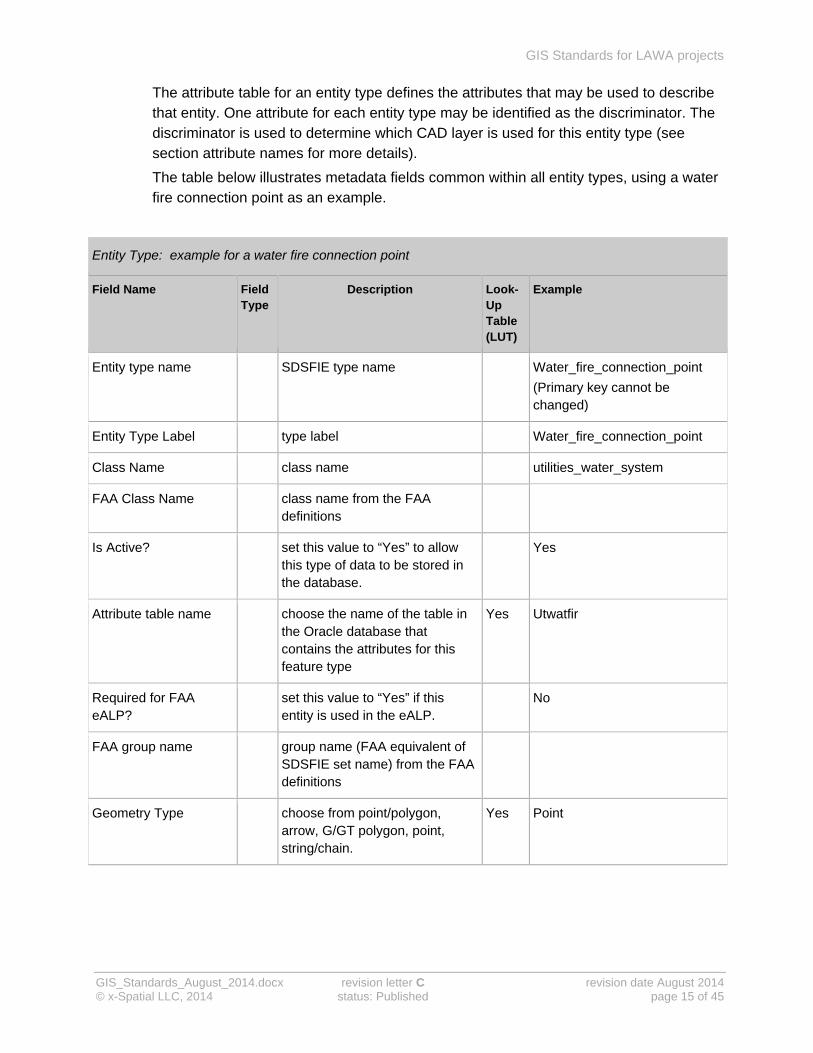
The attribute table for an entity type defines the attributes that may be used to describe that entity. One attribute for each entity type may be identified as the discriminator. The discriminator is used to determine which CAD layer is used for this entity type (see section attribute names for more details).
The table below illustrates metadata fields common within all entity types, using a water fire connection point as an example.
Entity Type: example for a water fire connection point
Field Name Field Type
Description Look-Up Table (LUT)
Example
Entity type name SDSFIE type name Water_fire_connection_point
(Primary key cannot be changed)
Entity Type Label type label Water_fire_connection_point
Class Name class name utilities_water_system
FAA Class Name class name from the FAA definitions
Is Active? set this value to “Yes” to allow this type of data to be stored in the database.
Yes
Attribute table name choose the name of the table in the Oracle database that contains the attributes for this feature type
Yes Utwatfir
Required for FAA eALP?
set this value to “Yes” if this entity is used in the eALP.
No
FAA group name group name (FAA equivalent of SDSFIE set name) from the FAA definitions
Geometry Type choose from point/polygon, arrow, G/GT polygon, point, string/chain.
Yes Point

GIS Standards for LAWA projects
GIS_Standards_August_2014.docx revision letter C revision date August 2014 © x-Spatial LLC, 2014 status: Published page 16 of 45
Entity Type: example for a water fire connection point
Field Name Field Type
Description Look-Up Table (LUT)
Example
Default Discriminator Entity types in the same class can be distinguished by using discriminators to describe them, for example Hydrant or Sprinkler for the entity-type, water-hydrant-point.
Yes FIRE_CONNECT
Interior feature set this value to “Yes” if this entity is or can be found inside buildings.
No
Mobile use set this value to “Yes” if this entity is available on the mobile device.
Yes
Geodatabase Export Options
Feature Class Name Water_fire_connection_point
Abbr. Feature Class Name
Create Feature Class? Yes
Participate in Geometric Network?
No
Feature Class Role Yes Simple Edge
Source Sink? No
SDSFIE definition
An apparatus which dispenses fluids for use in fire management.
FAA definition

GIS Standards for LAWA projects
GIS_Standards_August_2014.docx revision letter C revision date August 2014 © x-Spatial LLC, 2014 status: Published page 17 of 45
Look-up tables for entity types
Attribute table name (examples)
Value Description
Utwathyd water hydrant
utwatfir Water fire connection
Utwatmtr water meter
Utwatpip water pipe
Utwatpmp water pump
Geometry type
Value Description
Point / Polygon point / polygon
Arrow arrow
G/GT Polygon g/gt polygon
Point point
String / Chain string / chain
Discriminator (table adjusts according to attribute table defined)
Value Description
As-built Fire hydrant Fire hydrant, information from as-built records
Fire Connect Fire connection point
Fire Hydrant Fire Fire hydrant
Survey hydrant Fire hydrant, information from as-constructed survey

GIS Standards for LAWA projects
GIS_Standards_August_2014.docx revision letter C revision date August 2014 © x-Spatial LLC, 2014 status: Published page 18 of 45
Discriminators for entity types
Entities within the same entity type (for example, water fire connection points) can be distinguished by using discriminators (for example fire connector or fire hydrant).
Each discriminator of an entity type is assigned a CAD layer (and block, for point feature types) conforming to the LAWA CAD standards.
Within the AEGIS application the entity form displays the attributes and metadata fields that are relevant to each discriminator.
The table below illustrates discriminator fields common within all entity types, using a fire hydrant point as an example.
Entity
Field Name Field Type
Description Look-Up Table (LUT)
Example
Entity name name of the discriminator that will be created in the database Strict rules apply, for example no spaces, no non-alphanumeric characters.
utwat_fire_hydrant_p (primary key cannot be changed)
Discriminator Name used to describe this entity type.
FIRE_HYDRANT
Is active? Default “Yes” – the attribute is available to enter data.
Yes
Interior feature? Set this value to “Yes” if this discriminator is or can be used inside buildings.
No
Mobile Use? May be used on mobile device Yes
CADD Layer Name The name of the CADD layer to be used for entities with this discriminator: see LAWA CADD standards.
C-WATR-HYDR-FIRE
FAA CAD layer See FAA documentation.
CADD geometry type
The CADD geometry type (polyline, point/block or polygon) for this discriminator.
YES Point
CADD block name Block used to represent entities of this type. Only active when the geometry type is “point/block”.
HYDRNT

GIS Standards for LAWA projects
GIS_Standards_August_2014.docx revision letter C revision date August 2014 © x-Spatial LLC, 2014 status: Published page 19 of 45
Entity
Field Name Field Type
Description Look-Up Table (LUT)
Example
FAA CAD layer description
See FAA documentation.
Last updated by Updated by UMS
Last updated on Date last updated 08/11/2012
Look-up tables entity discriminators
CAD geometry type
Value Description
Polyline polyline
Point / Block point / block
Polygon polygon

GIS Standards for LAWA projects
GIS_Standards_August_2014.docx revision letter C revision date August 2014 © x-Spatial LLC, 2014 status: Published page 20 of 45
Attributes for entity types
Attributes consist of a name and a value, for example attribute label = hydrant type code.
Domain tables are look-up tables containing all possible valid values for an attribute, guaranteeing consistency. You can specify a domain table when creating a new attribute for an entity-type, or when editing an existing attribute.
Use domain tables when the user needs to choose a value from a single-column list or within a range of numeric values.
The table illustrates attributes common within all entity types, using water hydrant point as an example.
Attributes
Field Name Field Type
Description Look-Up Table (LUT)
Example
Attribute label Short, understandable name for use in data area and dialog boxes.
Hydrant Type Code
Attribute name Name of the field that will be created in the database
Strict rules apply, for example no spaces and no non-alphanumeric characters
hyd_ty_d
Position Determines position of entry in attribute list in data area.
31
Data type Data type, used for validation Yes Character
Max length Number of characters for this field. Only relevant for Character data.
16
Domain table name Predefined look-up table containing all possible valid values for this attribute
Yes type list – hydrant (d_tyhyd)
Foreign key tablename
To make information in an external table available as a list of possible values for an attribute, select the external (foreign) table from the drop-down and then click on the show details icon to select a field from that table.
Yes
Field name of foreign table

GIS Standards for LAWA projects
GIS_Standards_August_2014.docx revision letter C revision date August 2014 © x-Spatial LLC, 2014 status: Published page 21 of 45
Attributes
Field Name Field Type
Description Look-Up Table (LUT)
Example
Is Active? Default “Yes” – the attribute is available to enter data.
Yes
Editable? Default “Yes” – the value of the attribute can be edited.
Yes
Tooltip? Default “No”. Set to “Yes” to include this attribute and its value in the tooltip.
No
Required? Default “No”. Set to “Yes” to make this attribute mandatory.
No
Displayable? Default “Yes” – the attribute is listed in the pop-up window.
Yes
Show in list view Show in list view Yes
Mobile use? Available on mobile device No
FAA Required? Default “No”. Set to “Yes” to make this attribute mandatory for use in eALP
No
FAA attribute name Attribute name given by FAA, if available.
FAA common name Name given by FAA, if available.
FAA definition Entity type definition provided by the FAA, if available
SDSFIE definition Attribute definition from SDSFIE.
The particular kind, class, or group of hydrant

GIS Standards for LAWA projects
GIS_Standards_August_2014.docx revision letter C revision date August 2014 © x-Spatial LLC, 2014 status: Published page 22 of 45
Look-up tables for entity attributes
Data type
Value Description
Character Character
Integer number Integer number
Decimal number Decimal number
Date / Time Date / Time
d_tyhyd - Type code
Value Description
Airport airport hydrant
Building Building hydrant
Drinkfountain drink fountain
Drybarrel dry barrel
Freezeproof freeze proof
Fuel Fuel hydrant
Natgas natural gas hydrant
Other other
Streetwash street washer
TBD To Be Determined
Unknown unknown
Washtrack wash rack hydrant
water water hydrant
Wetbarrel wet barrel
Yard yard hydrant
GIS Standards for LAWA projects
GIS_Standards_August_2014.docx revision letter C revision date August 2014 © x-Spatial LLC, 2014 status: Published page 23 of 45
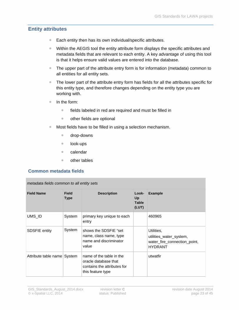
Entity attributes
Each entity then has its own individual/specific attributes.
Within the AEGIS tool the entity attribute form displays the specific attributes and metadata fields that are relevant to each entity. A key advantage of using this tool is that it helps ensure valid values are entered into the database.
The upper part of the attribute entry form is for information (metadata) common to all entities for all entity sets.
The lower part of the attribute entry form has fields for all the attributes specific for this entity type, and therefore changes depending on the entity type you are working with.
In the form:
fields labeled in red are required and must be filled in
other fields are optional
Most fields have to be filled in using a selection mechanism.
drop-downs
look-ups
calendar
other tables
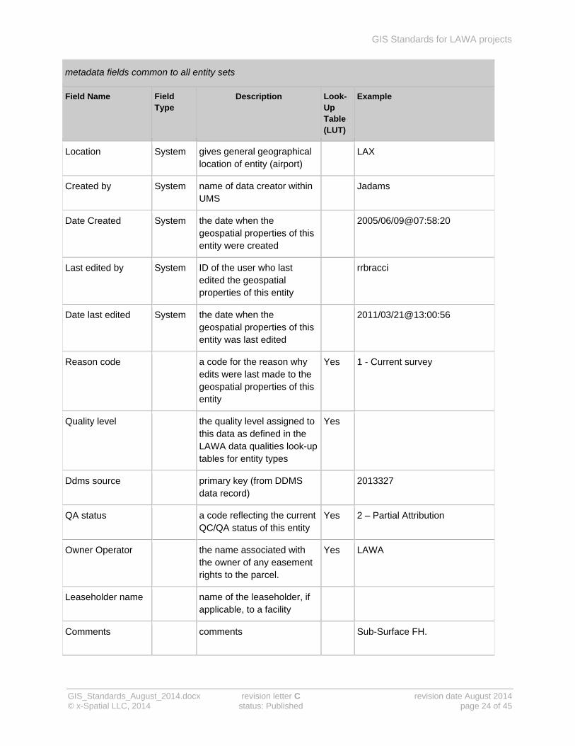
Common metadata fields
metadata fields common to all entity sets
Field Name Field Type
Description Look-Up Table (LUT)
Example
UMS_ID System primary key unique to each entry
460965
SDSFIE entity System shows the SDSFIE “set name, class name, type name and discriminator value
Utilities,
utilities_water_system, water_fire_connection_point, HYDRANT
Attribute table name System name of the table in the oracle database that contains the attributes for this feature type
utwatfir
GIS Standards for LAWA projects
GIS_Standards_August_2014.docx revision letter C revision date August 2014 © x-Spatial LLC, 2014 status: Published page 24 of 45
metadata fields common to all entity sets
Field Name Field Type
Description Look-Up Table (LUT)
Example
Location System gives general geographical location of entity (airport)
LAX
Created by System name of data creator within UMS
Jadams
Date Created System the date when the geospatial properties of this entity were created
2005/06/09@07:58:20
Last edited by System ID of the user who last edited the geospatial properties of this entity
rrbracci
Date last edited System the date when the geospatial properties of this entity was last edited
2011/03/21@13:00:56
Reason code a code for the reason why edits were last made to the geospatial properties of this entity
Yes 1 - Current survey
Quality level the quality level assigned to this data as defined in the LAWA data qualities look-up tables for entity types
Yes
Ddms source primary key (from DDMS data record)
2013327
QA status a code reflecting the current QC/QA status of this entity
Yes 2 – Partial Attribution
Owner Operator the name associated with the owner of any easement rights to the parcel.
Yes LAWA
Leaseholder name name of the leaseholder, if applicable, to a facility
Comments comments Sub-Surface FH.

GIS Standards for LAWA projects
GIS_Standards_August_2014.docx revision letter C revision date August 2014 © x-Spatial LLC, 2014 status: Published page 25 of 45
metadata fields common to all entity sets
Field Name Field Type
Description Look-Up Table (LUT)
Example
Disposition the state of readiness of the entity
Yes
Is published* the entity is available to view in ums
yes
* Required Field
Look-up tables for Entities
Reason code
Value Description
Current survey a new survey has provided more accurate information on the entity.
Records research new drawings and/or records have become available that provides additional or corrected information about the entity.
Correction this value was corrected due to a prior error.
Quality level
Value Description
Abandoned abandoned in place (not in use)
As built final set of information produced at the completion of a construction project
Compiled put together from information gathered from several sources
Design taken from plans for works to be executed
Flyover taken from flight over a specified area
GPS information from a global positioning system
Survey information from a LAWA approved survey

GIS Standards for LAWA projects
GIS_Standards_August_2014.docx revision letter C revision date August 2014 © x-Spatial LLC, 2014 status: Published page 26 of 45
QA Status
Value Description
Geometry only no attribute values have been populated, but the geometry has been created.
Partial attribution the geometry has been created, and some attributes have been added to the entity. the record is not yet complete.
Complete the geometry has been created, and the required attributes are current and complete.
Passed QA the geometry and attributes have passed the QA process.
Data migration data transferred between storage types or formats
Owner operator (sample only)
Value Description
AA American Airlines
ATT AT&T (Telecommunications)
CHVRN Chevron
City_LA City of Los Angeles
FAA Federal Aviation Authority
GTE GTE (Telecommunications)
LAFIRE Los Angeles Fire Department
LAWA Los Angeles World Airports
LAXFUEL Laxfuel Corporation

GIS Standards for LAWA projects
GIS_Standards_August_2014.docx revision letter C revision date August 2014 © x-Spatial LLC, 2014 status: Published page 27 of 45
Disposition
Value Description
ABANDONED abandoned in place (not in use)
BURIED buried
DEMOLOISHED Demolished
INACTIVE not currently in use
INCOMPLETE incomplete or unfinished
IN_SERVICE in service and being used.
OTHER other
PERMANAENT permanent
PROPOSED proposed
REMOVED Removed
RETIRED permanently retired, or taken out of service
TBD to be determined
TEMPORARY temporary
UNKNOWN unknown
Is published (Required Field)
Value Description
Y Yes
N No

GIS Standards for LAWA projects
GIS_Standards_August_2014.docx revision letter C revision date August 2014 © x-Spatial LLC, 2014 status: Published page 28 of 45
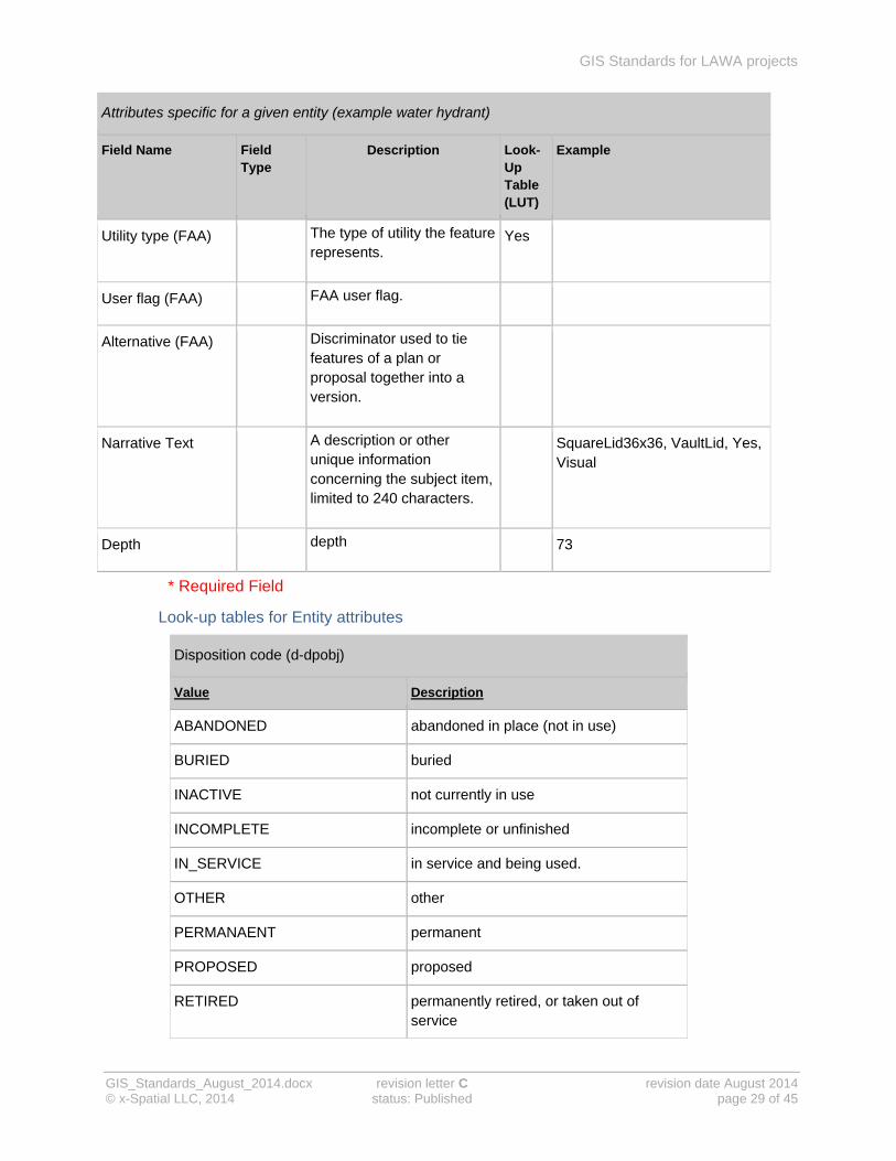
Specific metadata fields
Attributes specific to a given entity can be modified (extended or reduced) by an administrator according to LAWA requirements. Example for a Fire hydrant
Attributes specific for a given entity (example water hydrant)
Field Name Field Type
Description Look-Up Table (LUT)
Example
Disposition Code the operational status of the asset.
Yes In-Service
Design Code* Discriminator, This value differentiates fire connections by use or type.
Yes Fire Hydrant
Hydrant Type Code The particular kind, class, or group of hydrant.
Yes
Valve Style Code The style of the valve Yes
Size Code The manufacture’s designated size, or nominal diameter for the subject item (Fire Hydrant)
Yes 8
Invert Elevation The elevation of the hydrant, measured at the hydrant outlet, in feet (English units) above some datum.
Ground Elevation The elevation of the ground surface in feet (English units) above some datum.
Name (FAA) Name of the feature. Yes
Description (FAA) Description of the feature.
Status (FAA) A temporal description of the operational status of the feature. This attribute is used to describe real-time status.
Yes
GIS Standards for LAWA projects
GIS_Standards_August_2014.docx revision letter C revision date August 2014 © x-Spatial LLC, 2014 status: Published page 29 of 45
Attributes specific for a given entity (example water hydrant)
Field Name Field Type
Description Look-Up Table (LUT)
Example
Utility type (FAA) The type of utility the feature represents.
Yes
User flag (FAA) FAA user flag.
Alternative (FAA) Discriminator used to tie features of a plan or proposal together into a version.
Narrative Text A description or other unique information concerning the subject item, limited to 240 characters.
SquareLid36x36, VaultLid, Yes, Visual
Depth depth 73
* Required Field
Look-up tables for Entity attributes
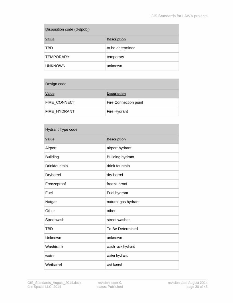
Disposition code (d-dpobj)
Value Description
ABANDONED abandoned in place (not in use)
BURIED buried
INACTIVE not currently in use
INCOMPLETE incomplete or unfinished
IN_SERVICE in service and being used.
OTHER other
PERMANAENT permanent
PROPOSED proposed
RETIRED permanently retired, or taken out of service
GIS Standards for LAWA projects
GIS_Standards_August_2014.docx revision letter C revision date August 2014 © x-Spatial LLC, 2014 status: Published page 30 of 45
Disposition code (d-dpobj)
Value Description
TBD to be determined
TEMPORARY temporary
UNKNOWN unknown
Design code
Value Description
FIRE_CONNECT Fire Connection point
FIRE_HYDRANT Fire Hydrant
Hydrant Type code
Value Description
Airport airport hydrant
Building Building hydrant
Drinkfountain drink fountain
Drybarrel dry barrel
Freezeproof freeze proof
Fuel Fuel hydrant
Natgas natural gas hydrant
Other other
Streetwash street washer
TBD To Be Determined
Unknown unknown
Washtrack wash rack hydrant
water water hydrant
Wetbarrel wet barrel

GIS Standards for LAWA projects
GIS_Standards_August_2014.docx revision letter C revision date August 2014 © x-Spatial LLC, 2014 status: Published page 31 of 45
Hydrant Type code
Value Description
Yard yard hydrant
Valve Style code
Value Description
Angle Type of Valve
Ball Type of Valve
Butterfly Type of Valve
Check Type of Valve
Drypipe Type of Valve
Gate Type of Valve
Globe Type of Valve
Needle Type of Valve
Other Type of Valve
Other Post Ind Type of Valve
Plug Type of Valve
Pressreducing Type of Valve
Press relief Type of Valve
Quad Type of Valve
Regulating Type of Valve
Stop waste Type of Valve
Swing check Type of Valve
TBD Type of Valve
Triple duty Type of Valve
Unknown Type of Valve

GIS Standards for LAWA projects
GIS_Standards_August_2014.docx revision letter C revision date August 2014 © x-Spatial LLC, 2014 status: Published page 32 of 45
Size code (sample only)
Value Description
6 size code 6
8 size code 8
Status (FAA)
Value Description
Abandoned abandoned
Active active
Airspaced air space
As_built as-built
Broken broken
Closed closed
Condemned condemned
Demolished demolished
ENV_cleared environmental cleared
Failed_AID failed aid
Inactive inactive
Limited limited
Long_term long term
Medium_term medium term
Non_operational non-operational
Occupied occupied
Operational operational
Other other
Parked parked
Permanent permanent

GIS Standards for LAWA projects
GIS_Standards_August_2014.docx revision letter C revision date August 2014 © x-Spatial LLC, 2014 status: Published page 33 of 45
Status (FAA)
Value Description
portable portable
Released released
Semi_permanent semi-permanent
Short_term short-term
S_power sustainable power
TBD TBD
Temporary temporary
Terminated terminated
Under_construction under-construction
Unknown Unknown
Unoccupied Unoccupied
Work_in_progress Work-in-progress
Utility Type (FAA)
Value Description
Communication_system communication system
Compressed_air_system compressed air system
Control_monitoring_ststem control monitoring system
Electrical_ext_lights electrical external lights
Electrical_system electrical system
Fuel_system fuel system
General_utility general utility
Heat_cool_system heat cool system
Industrial_system industrial system
Natural_gas_system natural gas system

GIS Standards for LAWA projects
GIS_Standards_August_2014.docx revision letter C revision date August 2014 © x-Spatial LLC, 2014 status: Published page 34 of 45
Utility Type (FAA)
Value Description
Nuclear_reactor nuclear reactor
Power_system power system
Salt_water_system salt water system
Storm_system storm system
Transmission_system transmission system
Waste_water_system waste water system
Water_system water system

GIS Standards for LAWA projects
GIS_Standards_August_2014.docx revision letter C revision date August 2014 © x-Spatial LLC, 2014 status: Published page 35 of 45
Entity naming conventions
Using GIS effectively at LAWA relies on the ability to distinguish adequately between subtle differences between entities. This permits greater value in output products by displaying entities based on predetermined criteria.
Each entity belongs to one specific entity type. The object type used to represent an entity graphically depends on the entity type it belongs to.
Entity names:
always begin with a prefix identifying the entity type and entity class the entity belongs to
have a suffix from the list in the next table
Entity name suffixes
non-text entities – each entity uses a layer which is unique within its entity class
b Boundary The line string forming the perimeter of an area
c Centroid An electronic point within the boundary to which the attribute table is attached
l String/Chain A collection of vertices, when taken as a whole, represent a line string on a map
p Point A single point representing the geographical location of a entity
text entities – all text entities for a given entity class use the same layer
a Label The placement and position of a displayable attribute within the attachment attribute code
t Text Any annotation relating to the entity that adequately conveys information about the map product
Examples of entities in entity class water system
Set name utilities
Class name Water system
Type name Water line
Attribute table name utwatpip
Entity Name Discriminator Value
Cad Layer Names
Description
utwat_line_abandoned_l Abandoned C-DOMW-ABND Abandoned piping
utwat_line_fire_l Fire C-DOMW-FIRE Fire lines
utwat_line_main_l Main C-DOMW-MAIN Main domestic water piping
utwat_line_service_l Service C-DOMW-SERV Domestic water service piping
utwat_line_sprinkler_l Sprinkler L-IRRG-PIPE Piping (Lawn sprinklers)

GIS Standards for LAWA projects
GIS_Standards_August_2014.docx revision letter C revision date August 2014 © x-Spatial LLC, 2014 status: Published page 36 of 45
Attribute tables
Attributes are the fields that can be used to describe each individual entity, and depend on the entity type the entity belongs to. The attributes available for each entity type are defined in attribute tables. All attribute tables are integrated in the AEGIS application.
Names for attribute tables
The names for LAWA attribute tables always start with the entity set and entity class prefix, for example utwat, and are always 8 characters long
Rows in attribute tables
Attribute tables always include contain: − a Primary Key field; the name of this field ends in _id
− a datalink field
Attribute names
− end in _d if valid values are defined by an attribute domain
− end in _id if they contain a primary or foreign key
Each entity type has a corresponding table in the database. The attributes that can be used to describe a particular entity depend on the entity type, so several entities will refer to the same attribute table. For example, while a main water line and a fire water line are different entities, they use the same attribute table because they belong in the same entity type.
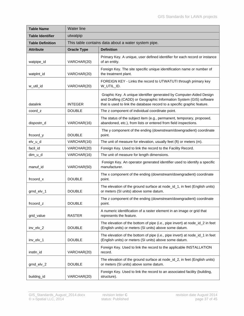
Example of (Water line) attribute table
Table Name Water line
Table Identifier utwatpip
Table Definition This table contains data about a water system pipe.
Attribute Oracle Type Definition
size_d VARCHAR(16)
The manufacturer's designated size, or nominal (i.e., rounded to the nearest unit) diameter for the subject item (e.g., 1 gas hydrant 2" meter 6" pipe). "
type_d VARCHAR(16) The kind, class, or group of the subject item.
source_d VARCHAR(16) The source type for the origin of a water system's water supply.
use_d VARCHAR(16) The use code for water pipes.
watzone_id VARCHAR(20) Foreign Key. Used to link the record to the appropriate utility management zone.
watstat_id VARCHAR(20) Foreign Key. Used to link the record to an associated station (pump station, pressure reducing station).
watsrce_id VARCHAR(20) Foreign Key. Used to link the pipe to an optional source.
watsect_id VARCHAR(20) Foreign Key. Used to link the record to an associated pipe or cable section.
wattank_id VARCHAR(20) Foreign Key. An operator generated identifier used to locally identify the subject item.
GIS Standards for LAWA projects
GIS_Standards_August_2014.docx revision letter C revision date August 2014 © x-Spatial LLC, 2014 status: Published page 37 of 45
Table Name Water line
Table Identifier utwatpip
Table Definition This table contains data about a water system pipe.
Attribute Oracle Type Definition
watpipe_id VARCHAR(20) Primary Key. A unique, user defined identifier for each record or instance of an entity.
watplnt_id VARCHAR(20) Foreign Key. The site specific unique identification name or number of the treatment plant.
w_util_id VARCHAR(20) FOREIGN KEY - Links the record to UTWATUTI through primary key W_UTIL_ID.
datalink INTEGER
Graphic Key. A unique identifier generated by Computer-Aided Design and Drafting (CADD) or Geographic Information System (GIS) software that is used to link the database record to a specific graphic feature.
coord_z DOUBLE The z component of individual coordinate point.
dispostn_d VARCHAR(16) The status of the subject item (e.g., permanent, temporary, proposed, abandoned, etc.), from lists or entered from field inspections.
frcoord_y DOUBLE The y component of the ending (downstream/downgradient) coordinate point.
elv_u_d VARCHAR(16) The unit of measure for elevation, usually feet (ft) or meters (m).
facil_id VARCHAR(20) Foreign Key. Used to link the record to the Facility Record.
dim_u_d VARCHAR(16) The unit of measure for length dimensions.
manuf_id VARCHAR(50) Foreign Key. An operator generated identifier used to identify a specific manufacturer.
frcoord_x DOUBLE The x component of the ending (downstream/downgradient) coordinate point.
grnd_elv_1 DOUBLE The elevation of the ground surface at node_id_1, in feet (English units) or meters (SI units) above some datum.
frcoord_z DOUBLE The z component of the ending (downstream/downgradient) coordinate point.
grid_value RASTER A numeric identification of a raster element in an image or grid that represents the feature.
inv_elv_2 DOUBLE The elevation of the bottom of pipe (i.e., pipe invert) at node_id_2 in feet (English units) or meters (SI units) above some datum.
inv_elv_1 DOUBLE The elevation of the bottom of pipe (i.e., pipe invert) at node_id_1 in feet (English units) or meters (SI units) above some datum.
instln_id VARCHAR(20) Foreign Key. Used to link the record to the applicable INSTALLATION record.
grnd_elv_2 DOUBLE The elevation of the ground surface at node_id_2, in feet (English units) or meters (SI units) above some datum.
buildng_id VARCHAR(20) Foreign Key. Used to link the record to an associated facility (building, structure).

GIS Standards for LAWA projects
GIS_Standards_August_2014.docx revision letter C revision date August 2014 © x-Spatial LLC, 2014 status: Published page 38 of 45
Table Name Water line
Table Identifier utwatpip
Table Definition This table contains data about a water system pipe.
Attribute Oracle Type Definition
catprot_d VARCHAR(16) Indicates whether or not the pipe has been provided with cathodic protection? (yes or no).
coord_id VARCHAR(20) Foreign Key. Used to link the record to the appropriate point coordinate record(s).
mat_d VARCHAR(16) The material composition of the subject item, such as wood, concrete, steel, cast iron, plastic, etc.
meta_id VARCHAR(20) Foreign Key. Used to link the record to the applicable feature level metadata record(s).
model_no VARCHAR(12) The Model, Product, Catalog, or Item Number of subject item.
media_id VARCHAR(20)
Foreign Key. Used to link the record to associated multimedia records that reference data such as imagery, video, audio, scanned documents, drawings, and other digital
map_id INTEGER Foreign Key. Used to link the record to the appropriate map.
narrative VARCHAR(240) A description or other unique information concerning the subject item, limited to 240 characters.
press_norm DOUBLE The normal operating pressure of the water system pipe.
press_max DOUBLE The manufacturer's or industry standard's maximum pressure rating of the subject item.
project_id VARCHAR(50)
Foreign Key. Used to link the record to the appropriate project or contract under which the item was studied, collected, installed, purchased, or managed.
pipe_lgth RASTER The length of pipe, measured from node to node along the pipe centerline .
owner_id VARCHAR(50) Foreign Key. Used to link the record to the owner.
user_flag VARCHAR(20)
An operator defined work area. This attribute can be used by the operator for user defined system processes. It does not effect the subject item's data integrity and should not be used to store the subject item's data.
press_u_d VARCHAR(16) The unit of measure for pressure.

GIS Standards for LAWA projects
GIS_Standards_August_2014.docx revision letter C revision date August 2014 © x-Spatial LLC, 2014 status: Published page 39 of 45
Domain values
Domains place a limit on the values that can be assigned to a specific attribute. SDSFIE contains two tables that define list domains and range domains.
Note: domain tables all have the prefix d_ in the name of the table, for example
d_watpip or d_headng
list domains contain a list of valid values
When an attribute is associated with a list domain, it is not possible to type in a value directly. The user has to select a pre-defined value from a pull-down.
range domains apply only to numeric value; they define a maximum value, a minimum value, or both. When an attribute is associated with a range domain, values outside the specified limits are not accepted.
example of a list domain.
Domain Table Name d_watpip
Domain Type List
Domain Definition Discriminator - Values that differentiate the general use of a water pipe.
Value List Domains_Definition
ABANDONED abandoned/inactive pipe
FIRE fire protection
MAIN main line
RAW_WATER raw water line
SERVICE building/facility service
SPRINKLER sprinkler head

GIS Standards for LAWA projects
GIS_Standards_August_2014.docx revision letter C revision date August 2014 © x-Spatial LLC, 2014 status: Published page 40 of 45
LAWA SDSFIE data dictionaries
The LAWA SDSFIE data dictionary for GIS attribute tables is integrated in the AEGIS application. Only attributes defined in this dictionary can be used. If additional attributes are found to be necessary, a variance form must be submitted and approved before the new attribute can be added to the data dictionary. The variance form is available from the LAWA website.
All LAWA GIS projects use this dictionary. It is organised by attribute table, and each table corresponds to an entity type. For each entity type, the dictionary gives:
attribute table information
valid attributes and their data types
the definition of each attribute
There is a separate LAWA SDSFIE data dictionary for graphical entities. Only entities defined in this dictionary can be used. If additional entities are needed, requests need to be submitted on the “Request for variance” form, this form along with other documentation related to these standards are available on the LAWA website. LAWA Standard Documents and Guidelines
example of a graphical properties for a waterline.
Graphical Properties for a waterline
Feature Type List
Domain Definition Allowable input for the disposition of an object
Table Identifier utwatpip
Table Definition A pipe used to carry water from location to location (main line, service line, vent line etc.)
Discriminator Value Entity Name Layer
Entity Alpha
Line Type
Line Width Color
Symbol Library
Symbol Name
ABANDONED utwat_line_abandoned_a 10 utwatlnaba 0 1 3 N/A N/A
ABANDONED utwat_line_abandoned_l 9 utwatlnabl 41 2 3 tssdslin N/A
ABANDONED utwat_line_abandoned_t 10 utwatlnabt 0 1 3 N/A N/A
FIRE utwat_line_fire_a 54 utwatfirea 0 1 3 N/A N/A
FIRE utwat_line_fire_l 54 utwatfirel 67 2 3 N/A N/A
FIRE utwat_line_fire_t 54 utwatfiret 0 1 3 N/A N/A
MAIN utwat_line_main_a 2 utwatlnmna 0 1 3 N/A N/A
MAIN utwat_line_main_l 1 utwatlnmnl 67 2 3 tssdslin N/A
MAIN utwat_line_main_t 2 utwatlnmnt 0 1 3 N/A N/A
RAW_WATER utwat_line_nonpotable_a 6 utwatlnnpa 0 1 3 N/A N/A
RAW_WATER utwat_line_nonpotable_l 5 utwatlnnpl 53 2 3 tssdslin N/A
RAW_WATER utwat_line_nonpotable_t 6 utwatlnnpt 0 1 3 N/A N/A
SERVICE utwat_line_service_a 4 utwatlnsva 0 1 3 N/A N/A
SERVICE utwat_line_service_l 3 utwatlnsvl 67 2 3 tssdslin N/A

GIS Standards for LAWA projects
GIS_Standards_August_2014.docx revision letter C revision date August 2014 © x-Spatial LLC, 2014 status: Published page 41 of 45
Graphical Properties for a waterline
Feature Type List
Domain Definition Allowable input for the disposition of an object
Table Identifier utwatpip
Table Definition A pipe used to carry water from location to location (main line, service line, vent line etc.)
Discriminator Value Entity Name Layer
Entity Alpha
Line Type
Line Width Color
Symbol Library
Symbol Name
SERVICE utwat_line_service_t 4 utwatlnsvt 0 1 3 N/A N/A
SIPHON utwat_line_siphon_a 56 utwatsipaa 0 1 3 N/A N/A
SIPHON utwat_line_siphon_l 55 utwatsipal 0 1 3 N/A N/A
SIPHON utwat_line_siphon_t 56 utwatsipat 0 1 3 N/A N/A
SPRINKLER utwat_line_sprinkler_a 8 utwatlnspa 0 1 3 N/A N/A
SPRINKLER utwat_line_sprinkler_l 7 utwatlnspl 20 2 3 tssdslin N/A
SPRINKLER utwat_line_sprinkler_t 8 utwatlnspt 0 1 3 N/A N/A
Data dictionary for graphical entities
All LAWA GIS projects use this dictionary. For each entity type, it gives:
discriminator value
entity name
CAD layer
Entity alpha
Unique alphabetic code (10 characters) for each entity. These codes always start with the map prefix for the entity class, and end with the letter corresponding to the entity type suffix.
Line, color and symbol information

GIS Standards for LAWA projects
GIS_Standards_August_2014.docx revision letter C revision date August 2014 © x-Spatial LLC, 2014 status: Published page 42 of 45
File names
SDSFIE uses a five-character prefix for map names and drawing-file names. This prefix is made up from the entity set code and the entity class code.
Example Map/file-name prefix
Entity Set Name Utilities
Entity Set Code ut
Entity Class Name Entity Class Abbreviation
Map Prefix Definition
Compressed Air System air utair The components of a compressed air system.
Control & Monitoring System
ecm utecm The components of an electronic monitoring and control (emcs) system including cables, devices, etc.
Electrical Exterior Lighting exl utexl The components of an electrical exterior lighting system including cables, switches, devices, transformers, etc.
Electrical System ele utele The components of an electrical distribution system including cables, switches, devices, motors, transformers, etc.
Fuel System ful utful The components of a fuel distribution system consisting of pipes, fittings, fixtures, pumps, tanks, etc.
General Utility Features gen utgen The components of a utility system which are universal in use and purpose and do not belong to a specific utility.
Heating & Cooling System hcs uthcs The components of a heating and cooling distribution system consisting of pipes, fittings, fixtures, etc.
Industrial System inw utinw The components of an industrial waste collection system including pipes, fittings, fixtures, tanks, lagoons, etc.
Natural Gas System gas utgas The components of a natural gas distribution system consisting of pipes, fittings, fixtures, etc.
Saltwater System swt utswt The components of a salt water collection system.
Storm System sto utsto The components of a storm drainage collection system including pipes, fittings, fixtures, etc.
Wastewater System wwt utwwt The components of a wastewater collection system including pipes, fittings, fixtures, treatment plants, collection locations, etc.
Water System wat utwat The components of a water system including pipes, fittings, valves, fixtures, treatment plants, etc.

GIS Standards for LAWA projects
GIS_Standards_August_2014.docx revision letter C revision date August 2014 © x-Spatial LLC, 2014 status: Published page 43 of 45
Entity Set Name Utilities (ut)
Entity Class Name Water system (wat)
Map Prefix utwat
Definition The components of a water system including pipes, valves, fixtures, treatment plants, etc.
Each user/installation can use unique suffixes to identify different versions and updates of map and drawing files.
By Date utwat20000516 or utwat51600
By Year utwat2000
Sequence Number utwat01
All files submitted must be compatible with LAWA hardware and software as follows:
GIS data files: ArcView Shape File, ESRI SDE, AutoCAD Map (a recent version)
vector graphics: AutoCAD (a recent version)
raster graphics: TIF, ECW, SID
digital media: CD-ROM, DVD-ROM, Flash drive, USB HD
GIS Standards for LAWA projects
GIS_Standards_August_2014.docx revision letter C revision date August 2014 © x-Spatial LLC, 2014 status: Published page 44 of 45
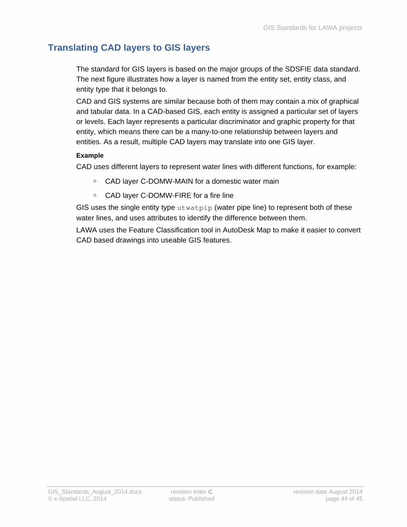
Translating CAD layers to GIS layers
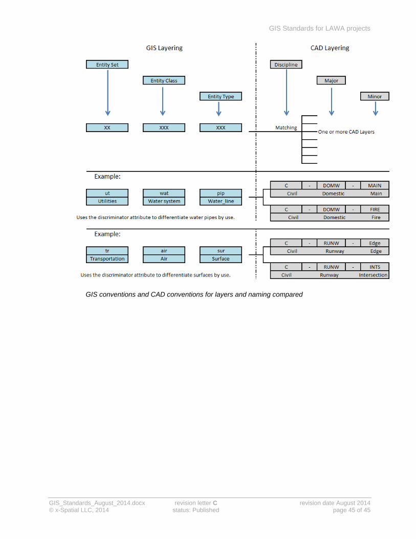
The standard for GIS layers is based on the major groups of the SDSFIE data standard. The next figure illustrates how a layer is named from the entity set, entity class, and entity type that it belongs to.
CAD and GIS systems are similar because both of them may contain a mix of graphical and tabular data. In a CAD-based GIS, each entity is assigned a particular set of layers or levels. Each layer represents a particular discriminator and graphic property for that entity, which means there can be a many-to-one relationship between layers and entities. As a result, multiple CAD layers may translate into one GIS layer.
Example
CAD uses different layers to represent water lines with different functions, for example:
CAD layer C-DOMW-MAIN for a domestic water main
CAD layer C-DOMW-FIRE for a fire line
GIS uses the single entity type utwatpip (water pipe line) to represent both of these
water lines, and uses attributes to identify the difference between them.
LAWA uses the Feature Classification tool in AutoDesk Map to make it easier to convert CAD based drawings into useable GIS features.
GIS Standards for LAWA projects
GIS_Standards_August_2014.docx revision letter C revision date August 2014 © x-Spatial LLC, 2014 status: Published page 45 of 45
GIS conventions and CAD conventions for layers and naming compared