glacier hazard formation and evaluation in the northern ... · hunza valley and one of its major...
TRANSCRIPT
Glacier hazard formation and evaluationin the Northern Areas of Pakistan
D.J. Quincey and S.D. RichardsonCentre for Glaciology, Institute of Geography and Earth Sciences, Aberystwyth University, UK ([email protected])
Glacial Lake Outburst Floods (GLOFs) associated with thinning and retreating glaciers are widespread in the high-mountain ranges of Asia. Glaciers in the Karakoram range, however, do not appear to be conforming to global trends and many are thickening and advancing1. Here we show examples
1. Introduction
2. Ghulkin Glacier: multiple hazard types during an advanceFrom 2003/04 to 2004/05 flow velocities over the lower 9 km of Ghulkin Glacier increased uniformly by ≥ 25%. Velocities have since slowed in the middle reaches of the glacier but have remained high (≥ 110 m a-1) at the terminus, which in 2008 was advancing and overriding its moraine.
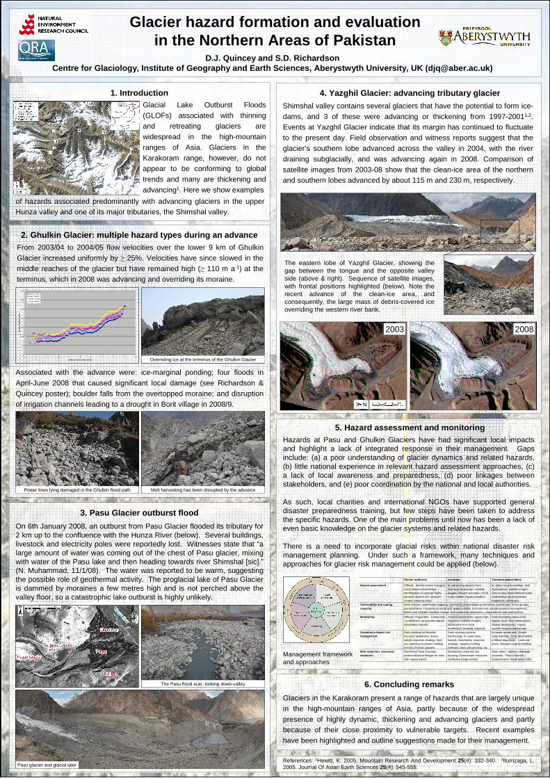
4. Yazghil Glacier: advancing tributary glacier
5. Hazard assessment and monitoring
6. Concluding remarks
Glaciers in the Karakoram present a range of hazards that are largely unique in the high-mountain ranges of Asia, partly because of the widespread presence of highly dynamic, thickening and advancing glaciers and partly because of their close proximity to vulnerable targets. Recent examples have been highlighted and outline suggestions made for their management.
References: 1Hewitt, K. 2005. Mountain Research And Development 25(4): 332-340. 2Iturrizaga, L. 2005. Journal Of Asian Earth Sciences 25(4): 545-555.
3. Pasu Glacier outburst flood
On 6th January 2008, an outburst from Pasu Glacier flooded its tributary for 2 km up to the confluence with the Hunza River (below). Several buildings, livestock and electricity poles were reportedly lost. Witnesses state that “a large amount of water was coming out of the chest of Pasu glacier, mixing with water of the Pasu lake and then heading towards river Shimshal [sic].”(N. Muhammad, 11/1/08). The water was reported to be warm, suggesting the possible role of geothermal activity. The proglacial lake of Pasu Glacier is dammed by moraines a few metres high and is not perched above the valley floor, so a catastrophic lake outburst is highly unlikely.
Hazards at Pasu and Ghulkin Glaciers have had significant local impacts and highlight a lack of integrated response in their management. Gaps include: (a) a poor understanding of glacier dynamics and related hazards, (b) little national experience in relevant hazard assessment approaches, (c) a lack of local awareness and preparedness, (d) poor linkages between stakeholders, and (e) poor coordination by the national and local authorities.
As such, local charities and international NGOs have supported general disaster preparedness training, but few steps have been taken to address the specific hazards. One of the main problems until now has been a lack of even basic knowledge on the glacier systems and related hazards.
There is a need to incorporate glacial risks within national disaster risk management planning. Under such a framework, many techniques and approaches for glacier risk management could be applied (below).
Shimshal valley contains several glaciers that have the potential to form ice-dams, and 3 of these were advancing or thickening from 1997-20011,2. Events at Yazghil Glacier indicate that its margin has continued to fluctuate to the present day. Field observation and witness reports suggest that the glacier’s southern lobe advanced across the valley in 2004, with the river draining subglacially, and was advancing again in 2008. Comparison of satellite images from 2003-08 show that the clean-ice area of the northern and southern lobes advanced by about 115 m and 230 m, respectively.
The eastern lobe of Yazghil Glacier, showing the gap between the tongue and the opposite valley side (above & right). Sequence of satellite images, with frontal positions highlighted (below). Note the recent advance of the clean-ice area, and consequently, the large mass of debris-covered ice overriding the western river bank.
Associated with the advance were: ice-marginal ponding; four floods in April-June 2008 that caused significant local damage (see Richardson &Quincey poster); boulder falls from the overtopped moraine; and disruption of irrigation channels leading to a drought in Borit village in 2008/9.
Glacier outbursts Ice-dams Transient glacial lakes
Hazard assessment Difficult. Identify known hot-spots using historical knowledge; identification of surging/ highly dynamic glaciers (for advance-related outbursts only).
Id. advancing glaciers from historical knowledge / satellite images. Breach scenarios / flood route models; hazard zonation.
Id. lakes: local knowledge, field observations, satellite images. Glacier-lake-impoundment-target relationships (burst potential; magnitude; pathways).
Vulnerability and coping capacity
Desk reviews, stakeholder mapping, community personal/group interviews; workshops / focus groups; questionnaires. Focusing on social and spatial mobility, food security, natural resource management, beliefs and attitudes towards change, and community awareness, preparedness and participation.
Monitoring Difficult / impossible. Community / landholders can provide regular observation reports.
Field measurements; repeat high-resolution satellite imagery; information from local landholders (training required).
Fast-developing lakes need regular local / field observations. Slower-developing – repeat satellite imagery appropriate.
Community-based risk management
Early warning not feasible. Increase awareness; devise simple response strategy; land-use planning to prevent building in front of known glaciers.
Early warning systems (technology- or community-based). Awareness; response strategy, capacity building (relevant) land use planning, etc.
Increase awareness. Simple early warning – local observation & linked responses. Land use plans, relevant capacity building.
Risk reduction: structural measures
Reinforced flood channels, protected/raised bridges for sites with repeat events.
Maintaining channels: ice-blasting. Downstream measures ineffective (large events).
Drain lakes - siphons; drainage channels. Flood channels / embankments (small lakes only).
Management frameworkand approaches
0
50
100
150
200
250
300
350
0 1 2 3 4 5 6 7 8 9 10
Distance from terminus (km)
Su
rfac
e ve
loc
ity
(m/y
r)
Sept03_July04July04_Sept05
Sept05_June06
June06_April07
April07_April08
2003 2008
N
of hazards associated predominantly with advancing glaciers in the upper Hunza valley and one of its major tributaries, the Shimshal valley.
Overriding ice at the terminus of the Ghulkin Glacier
Power lines lying damaged in the Ghulkin flood path Melt harvesting has been disrupted by the advance
The Pasu flood scar, looking down-valley
Pasu glacier and glacial lake