glen eira urban context report - working d · great public spaces (direction 4.1) and achieve and...
TRANSCRIPT
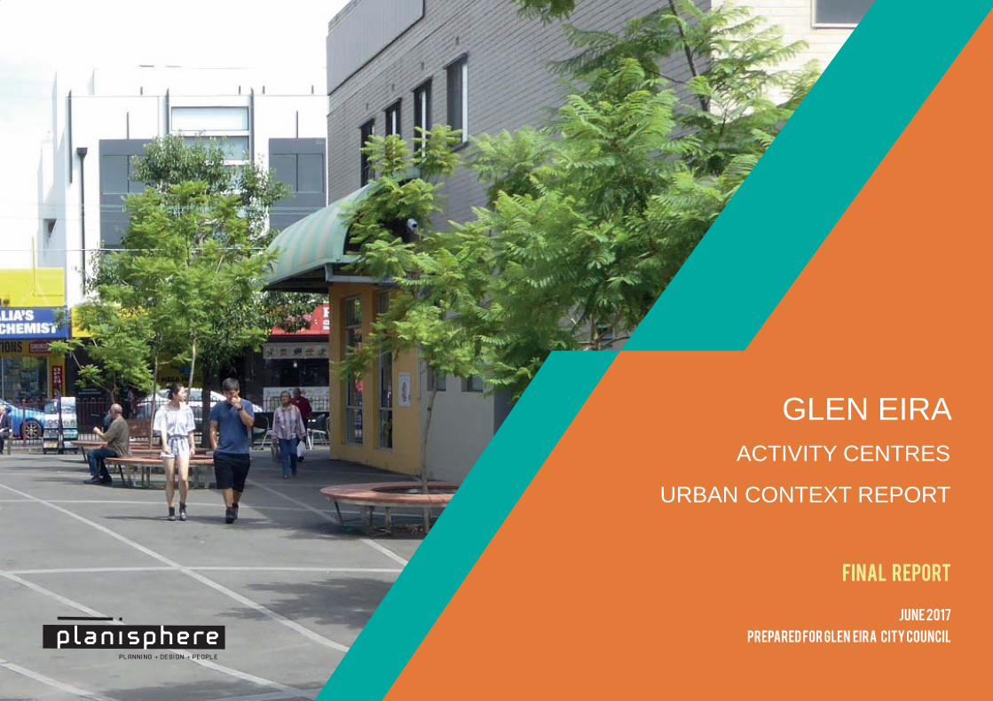
GLEN EIRAACTIVITY CENTRES
URBAN CONTEXT REPORT
FINAL REPORT
PREPARED FOR GLEN EIRA CITY COUNCIL
JUNE 2017
Status VersionChecked PM
Checked PD Date released
Final Report 1 HK LR 9.6.17
Final Report (Removed Typologies and Amended AC Map)
2 TN LR 28.6.17
© Planisphere 2017.
This Publication is copyright. No part may be reproduced by any process except in accordance with the provisions of the Copyright Act 1968.
PROJECT CONTROL
Contents1 Background 3
2 Glen Eira Activity Centres Urban Context 9
3 Development Issues & Opportunities 19
4 Building Typologies 29
5 Review of Built Form & Design Controls 37

GLEN EIRA COUNCIL | GLEN EIRA URBAN DESIGN GUIDELINES2 GLEN EIRA COUNCIL | GLEN EIRA URBAN DESIGN GUIDELINES

GLEN EIRA COUNCIL | GLEN EIRA URBAN DESIGN GUIDELINES 3GLEN EIRA COUNCIL | GLEN EIRA URBAN DESIGN GUIDELINES
Background
1
4 © 2017GLEN EIRA COUNCIL | GLEN EIRA URBAN DESIGN GUIDELINES
Introduction
Project OverviewThe purpose of this project is to review the urban context of Glen Eira’s activity centres and prepare urban design guidelines that will improve development outcomes for all people in the community.
Current pressure for higher density development, level crossing removals projects and a change in household composition trigger the need for well considered strategic planning to ensure Glen Eira is prepared for change.
The extent of the Neighbourhood Residential Zone (NRZ) across Glen Eira places pressure on the General Residential Zone (GRZ) and activity centres to accommodate intensive development.
Urban Design Guidelines and detailed consideration of specific sites is required to manage the interface between activity centres, the GRZ and NRZ.
Numerous issues about new development have been raised by local residents through the planning approvals process and the local media.
These include the application of height controls within activity centres, the need to provide a diversity of dwelling types, protection of neighbourhood character, providing adequate car parking and alignment of apartment standards and private open space provisions in each development.
The purpose of this project is to prepare urban design guidelines that can be applied to activity centres and implemented through the Glen Eira Planning Scheme. This will help to reach a greater certainty of outcome for Council, developers and the community.
The project will also explore the potential for the development process to capture opportunities for community benefit, in the form of new community facilities or open space.
The project outcomes will be aligned with the draft Activity Centre, Housing and Local Economy Strategy currently under preparation by Council.
Project Scope & TasksThe scope and tasks of the project brief are to:
▪ Document the built form characteristics of Glen Eira’s activity centres, considering the design issues raised by recent development in each zone.
▪ Review community feedback on development issues.
▪ Review the typologies for future development within and around activity centres currently being developed in Council’s Activity Centres Strategy, and prepare built form guidelines for each typology.
▪ Review the recently reformed residential zones and new apartment design standards (Clause 58 of the Planning Scheme) to determine how they can be applied to achieve preferred design outcomes.
▪ Prepare built form guidelines for each typology to respond to the design objectives specific to Glen Eira’s activity centres, in addition to the provisions of the new zones and apartment standards.
▪ Explore options to develop a system of ‘community benefit’ measures which could facilitate the provision of community infrastructure or open space through development outcomes on strategic sites or within urban renewal areas.
▪ Review the provisions of the Commercial 1 Zone, General Residential Zone and Residential Growth Zone with a view to including improved objectives and design parameters for areas within and around activity centres.
Next Steps
This report has been prepared for consultation and discussion with the community about the future built form of Glen Eira’s activity centres.
Following consultation, the typologies will be further refined to respond to community feedback. Detailed design requirements, including building heights and setbacks, will be determined for each typology. Ultimately, these requirements will be included in the Glen Eira Planning Scheme.
5© 2017 GLEN EIRA COUNCIL | GLEN EIRA URBAN DESIGN GUIDELINES
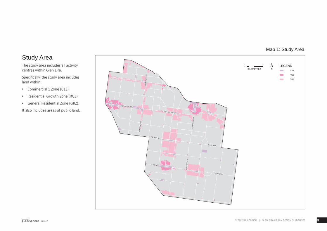
Study AreaThe study area includes all activity centres within Glen Eira.
Specifically, the study area includes land within:
▪ Commercial 1 Zone (C1Z)
▪ Residential Growth Zone (RGZ)
▪ General Residential Zone (GRZ).
It also includes areas of public land.
KOO
RN
ANG
RD
KOO
RN
ANG
RD
HAW
THO
RN
RD
HAW
THO
RN
RD
HAW
THO
RN
RD
HAW
THO
RN
RD
KOO
RN
ANG
RD
KOO
RN
ANG
RD
GLEN HUNTLY RDGLEN HUNTLY RD
CENTRE RDCENTRE RD
NORTH RDNORTH RD
NORTH RDNORTH RD
CENTRE RDCENTRE RD
GLEN HUNTLY RDGLEN HUNTLY RD
LEGENDC1Z
RGZ
GRZ
NKILOMETRES
0 1
Map 1: Study Area
6 © 2017GLEN EIRA COUNCIL | GLEN EIRA URBAN DESIGN GUIDELINES
Planning Policies set out by the State Government and Council will influence the form and location of different development types and densities.
Plan Melbourne & State Planning PolicyPlan Melbourne sets out the strategic planning framework for metropolitan Melbourne to 2050. It is a high level strategy that develops key principles, directions and policies that support a long-term vision for the future development of Melbourne.
The Strategy advocates for managing the supply of new housing in the right locations (Direction 2.1), delivering more housing closer to jobs and public transport (Direction 2.2), creating great public spaces (Direction 4.1) and achieve and promote design excellence (Direction 4.3).
Various State Planning Policy Provisions relate to activity centres:
▪ Clause 11, Settlement
▪ Clause 15, Built Environment and Heritage
▪ Clause 16, Housing
▪ Clause 17, Economic Development
This policies encourage densification around existing activity centres or locations with good access to transport, in particular public
Strategic Context
transport, and other services and facilities.
They also encourage a high standard of design quality in the private and public realms, to create a stong sense of local identity.
Clause 11.06-4 Place and identity has an objective of particular relevance to this project: ‘To create a distinctive and liveable city with quality design and amenity’.
Local Planning Policy Council’s Local Planning Policy Provisions related to activity centre planning and design are:
▪ Clause 21.03: Vision – Strategic Framework
▪ Clause 21.04: Housing and Residential Development
▪ Clause 21.06: Business
▪ Clause 22.05: Urban Villages Policy.
Council’s Vision – Strategic Framework notes activity centres (urban villages) as ‘...typically characterised by: mixed use areas, a pedestrian scale with increased casual surveillance, interconnected modes of public
transport, public areas and open space and a range of dwellings and higher density of dwellings’.
Other key objectives include:
▪ To ensure a greater diversity of housing to meet future housing needs
▪ To improve and protect the liveability, neighbourhood character and amenity of Glen Eira
▪ To promote environmental, social and economic sustainability
▪ To stimulate and improve the vitality of Glen Eira’s commercial centres
▪ To maintain a mix of commercial centres that cater for the needs of the Glen Eira community.
▪ To enhance and further develop urban villages and neighbourhood centres as the focus for community life.
7© 2017 GLEN EIRA COUNCIL | GLEN EIRA URBAN DESIGN GUIDELINES
Draft Activity Centre, Housing & Local Economy Strategy Council has prepared a draft Activity Centre, Housing & Local Economy Strategy to provide direction about the future growth and change of its activity centres.
The draft strategy sets out a vision for 2031:
Glen Eira will be a city of walkable neighbourhoods that are centred on a network of vibrant, socially inclusive and well designed activity centres, providing for the needs of and reflecting the character of their communities.
The draft strategy includes four sections:
1. Proposed Activity Centres Framework
An overarching framework that provides a place-based approach to implementing place-making, local economy and local housing outcomes.
2. Place-making
Setting a new integrated framework to plan for areas of change and activity centres.
Strengthening the uniqueness of our neighbourhoods by setting shared visions for each of our activity centres.
3. Local economy
Outlining a new framework for the creation of more local jobs for our future community.
4. Housing
Outlining an updated framework for planning our community’s future housing needs.
8 © 2017GLEN EIRA COUNCIL | GLEN EIRA URBAN DESIGN GUIDELINES
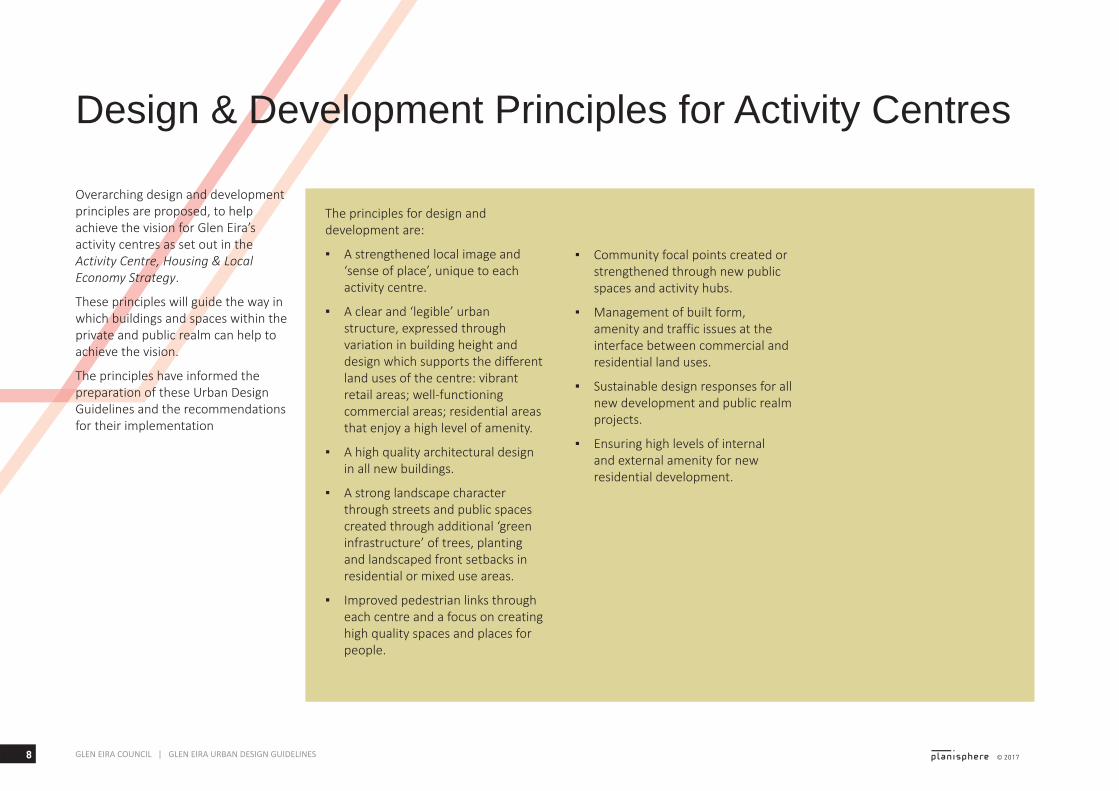
Overarching design and development principles are proposed, to help achieve the vision for Glen Eira’s activity centres as set out in the Activity Centre, Housing & Local Economy Strategy.
These principles will guide the way in which buildings and spaces within the private and public realm can help to achieve the vision.
The principles have informed the preparation of these Urban Design Guidelines and the recommendations for their implementation
The principles for design and development are:
▪ A strengthened local image and ‘sense of place’, unique to each activity centre.
▪ A clear and ‘legible’ urban structure, expressed through variation in building height and design which supports the different land uses of the centre: vibrant retail areas; well-functioning commercial areas; residential areas that enjoy a high level of amenity.
▪ A high quality architectural design in all new buildings.
▪ A strong landscape character through streets and public spaces created through additional ‘green infrastructure’ of trees, planting and landscaped front setbacks in residential or mixed use areas.
▪ Improved pedestrian links through each centre and a focus on creating high quality spaces and places for people.
▪ Community focal points created or strengthened through new public spaces and activity hubs.
▪ Management of built form, amenity and traffic issues at the interface between commercial and residential land uses.
▪ Sustainable design responses for all new development and public realm projects.
▪ Ensuring high levels of internal and external amenity for new residential development.
Design & Development Principles for Activity Centres
9GLEN EIRA COUNCIL | GLEN EIRA URBAN DESIGN GUIDELINES
Glen Eira Activity Centres Urban Context
2
10 © 2017GLEN EIRA COUNCIL | GLEN EIRA URBAN DESIGN GUIDELINES
Glen Eira Activity Centres Urban Context
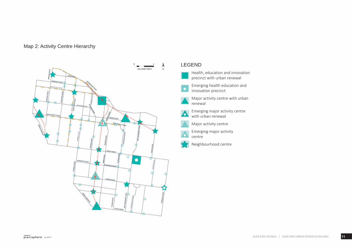
Activity Centres FrameworkGlen Eira has a large number of activity centres spread throughout the municipality, which range in size and function (shown on Map 2, opposite).
Council’s draft Activity Centre, Housing and Local Economy Strategy (2017) sets out a framework for the different types of activity centres within the municipality. The framework includes the following categories of centres:
▪ Health, education & innovation precinct with urban renewal
▪ Emerging education & innovation precinct
▪ Major activity centre with urban renewal
▪ Emerging major activity centre with urban renewal
▪ Major activity centre
▪ Emerging major activity centre
▪ Neighbourhood centre
▪ Commercially zoned land.
This framework of activity centres reflects their complex nature and varied roles.
This chapter provides an overview of the urban form and context of the Major Activity Centres and Neighbourhood Centres, and surrounding residential areas which are identified as potentially accommodating additional growth - those within the Residential Growth or General Residential Zones.
Strategic sites & urban renewal sites
Within these centres are larger strategic sites and urban renewal sites which offer specific development opportunities.
Strategic sites are large sites within established commercial or residential areas on which a higher density or scale of development could be achieved due to the large site area.
For example, this could include:
▪ Public and supermarket car parks in activity centres
▪ Supermarket sites
▪ Selected railway stations
▪ Selected sites that are amalgamated or already have a large minimum area and frontage.
Urban renewal sites are discreet areas without sensitive interface conditions where an even greater density or scale of development could be achieved.
They include:
▪ Car sales sites etc. facing the Nepean Highway near Elsternwick, Gardenvale and Moorabbin.
▪ Zagame’s site Caulfield – part of the land bounded by Derby Road, Dandenong Road and Sir John Monash Drive Caulfield/Phoenix Precinct (now referred to as Caulfield Junction)
▪ Dandenong Road, Carnegie
11© 2017 GLEN EIRA COUNCIL | GLEN EIRA URBAN DESIGN GUIDELINES
Map 2: Activity Centre Hierarchy
NKILOMETRES
0 1 LEGENDHealth, education and innovation precinct with urban renewal
Emerging health education and innovation precinct
Major activity centre with urban renewal
Emerging major activity centre with urban renewal
Major activity centre
Emerging major activity centre
Neighbourhood centre
12 © 2017GLEN EIRA COUNCIL | GLEN EIRA URBAN DESIGN GUIDELINES
Major Activity Centres
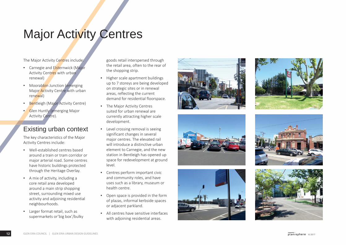
The Major Activity Centres include:
▪ Carnegie and Elsternwick (Major Activity Centres with urban renewal)
▪ Moorabbin Junction (emerging Major Activity Centre with urban renewal)
▪ Bentleigh (Major Activity Centre)
▪ Glen Huntly (emerging Major Activity Centre).
Existing urban contextThe key characteristics of the Major Activity Centres include:
▪ Well-established centres based around a train or tram corridor or major arterial road. Some centres have historic buildings protected through the Heritage Overlay.
▪ A mix of activity, including a core retail area developed around a main strip shopping street, surrounding mixed use activity and adjoining residential neighbourhoods.
▪ Larger format retail, such as supermarkets or’big box’/bulky
goods retail interspersed through the retail area, often to the rear of the shopping strip.
▪ Higher scale apartment buildings up to 7 storeys are being developed on strategic sites or in renewal areas, reflecting the current demand for residential floorspace.
▪ The Major Activity Centres suited for urban renewal are currently attracting higher scale development.
▪ Level crossing removal is seeing significant changes in several major centres. The elevated rail will introduce a distinctive urban element to Carnegie, and the new station in Bentleigh has opened up space for redevelopment at ground level.
▪ Centres perform important civic and community roles, and have uses such as a library, museum or health centre.
▪ Open space is provided in the form of plazas, informal kerbside spaces or adjacent parkland.
▪ All centres have sensitive interfaces with adjoining residential areas.
13© 2017 GLEN EIRA COUNCIL | GLEN EIRA URBAN DESIGN GUIDELINES
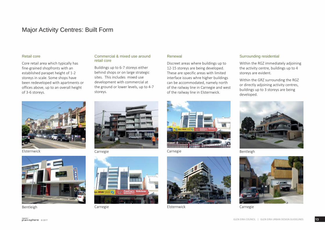
Major Activity Centres: Built Form
Retail core
Core retail area which typically has fine-grained shopfronts with an established parapet height of 1-2 storeys in scale. Some shops have been redeveloped with apartments or offices above, up to an overall height of 3-6 storeys.
Commercial & mixed use around retail core
Buildings up to 6-7 storeys either behind shops or on large strategic sites. This includes mixed use development with commercial at the ground or lower levels, up to 4-7 storeys.
Surrounding residential
Within the RGZ immediately adjoining the activity centre, buildings up to 4 storeys are evident.
Within the GRZ surrounding the RGZ or directly adjoining activity centres, buildings up to 3 storeys are being developed.
Renewal
Discreet areas where buildings up to 12-15 storeys are being developed. These are specific areas with limited interface issues whre higher buildings can be accommodated, namely north of the railway line in Carnegie and west of the railway line in Elsternwick.
Elsternwick
Bentleigh
Carnegie Carnegie
Elsternwick
Bentleigh
Carnegie Carnegie
14 © 2017GLEN EIRA COUNCIL | GLEN EIRA URBAN DESIGN GUIDELINES
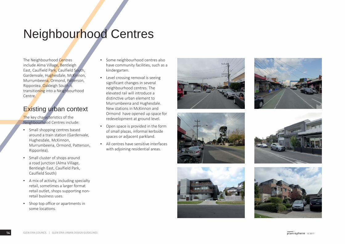
Neighbourhood Centres
The Neighbourhood Centres include Alma Village, Bentleigh East, Caulfield Park, Caulfield South, Gardenvale, Hughesdale, McKinnon, Murrumbeena, Ormond, Patterson, Ripponlea. Oakleigh South is transitioning into a Neighbourhood Centre.
Existing urban contextThe key characteristics of the Neighbourhood Centres include:
▪ Small shopping centres based around a train station (Gardenvale, Hughesdale, McKinnon, Murrumbeena, Ormond, Patterson, Ripponlea).
▪ Small cluster of shops around a road junction (Alma Village, Bentleigh East, Caulfield Park, Caulfield South)
▪ A mix of activity, including specialty retail, sometimes a larger format retail outlet, shops supporting non-retail business uses.
▪ Shop top office or apartments in some locations.
▪ Some neighbourhood centres also have community facilities, such as a kindergarten.
▪ Level crossing removal is seeing significant changes in several neighbourhood centres. The elevated rail will introduce a distinctive urban element to Murrumbeena and Hughesdale. New stations in McKinnon and Ormond have opened up space for redevelopment at ground level.
▪ Open space is provided in the form of small plazas, informal kerbside spaces or adjacent parkland.
▪ All centres have sensitive interfaces with adjoining residential areas.
15© 2017 GLEN EIRA COUNCIL | GLEN EIRA URBAN DESIGN GUIDELINES
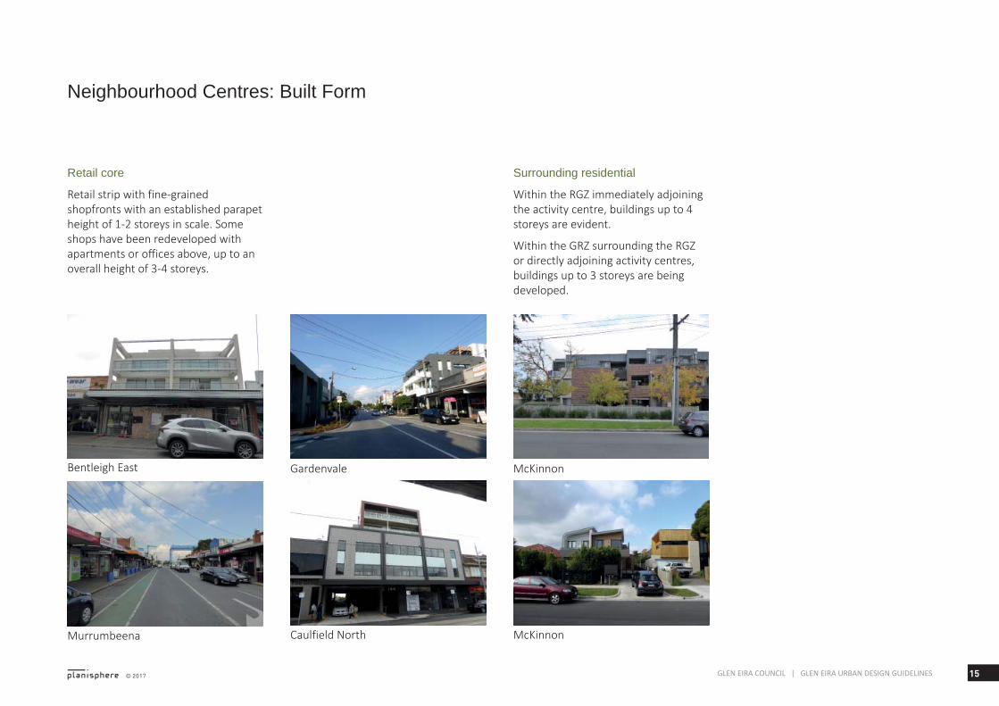
Neighbourhood Centres: Built Form
Retail core
Retail strip with fine-grained shopfronts with an established parapet height of 1-2 storeys in scale. Some shops have been redeveloped with apartments or offices above, up to an overall height of 3-4 storeys.
Surrounding residential
Within the RGZ immediately adjoining the activity centre, buildings up to 4 storeys are evident.
Within the GRZ surrounding the RGZ or directly adjoining activity centres, buildings up to 3 storeys are being developed.
Bentleigh East
Murrumbeena
Gardenvale McKinnon
Caulfield North McKinnon
16 © 2017GLEN EIRA COUNCIL | GLEN EIRA URBAN DESIGN GUIDELINES
Renewal Areas
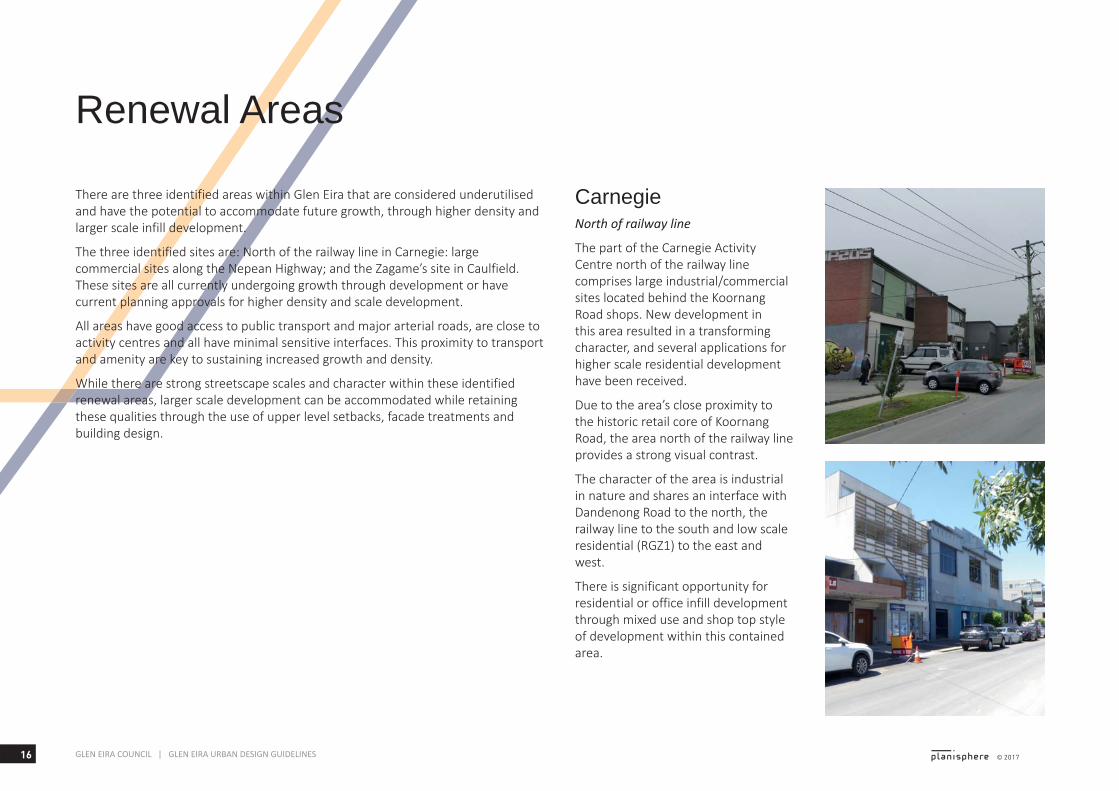
CarnegieNorth of railway line
The part of the Carnegie Activity Centre north of the railway line comprises large industrial/commercial sites located behind the Koornang Road shops. New development in this area resulted in a transforming character, and several applications for higher scale residential development have been received.
Due to the area’s close proximity to the historic retail core of Koornang Road, the area north of the railway line provides a strong visual contrast.
The character of the area is industrial in nature and shares an interface with Dandenong Road to the north, the railway line to the south and low scale residential (RGZ1) to the east and west.
There is significant opportunity for residential or office infill development through mixed use and shop top style of development within this contained area.
There are three identified areas within Glen Eira that are considered underutilised and have the potential to accommodate future growth, through higher density and larger scale infill development.
The three identified sites are: North of the railway line in Carnegie: large commercial sites along the Nepean Highway; and the Zagame’s site in Caulfield. These sites are all currently undergoing growth through development or have current planning approvals for higher density and scale development.
All areas have good access to public transport and major arterial roads, are close to activity centres and all have minimal sensitive interfaces. This proximity to transport and amenity are key to sustaining increased growth and density.
While there are strong streetscape scales and character within these identified renewal areas, larger scale development can be accommodated while retaining these qualities through the use of upper level setbacks, facade treatments and building design.
17© 2017 GLEN EIRA COUNCIL | GLEN EIRA URBAN DESIGN GUIDELINES
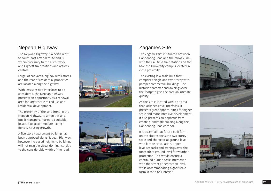
Nepean HighwayThe Nepwan Highway is a north-west to south-east arterial route and is within proximity to the Elsternwick and Highett train stations and activity centres.
Large lot car yards, big box retail stores and the rear of residential properties are located along the highway.
With less sensitive interfaces to be considered, the Nepean Highway presents an opportunity as a renewal area for larger scale mixed use and residential development.
The proximity of the land fronting the Nepean Highway, to amenities and public transport, makes it a suitable location to accommodate higher density housing growth.
A five storey apartment building has been approved along Nepean Highway, however increased heights to buildings will not result in visual dominance, due to the considerable width of the road.
Zagames SiteThe Zagames site is situated between Dandenong Road and the railway line, with the Caulfield train station and the Monash University campus located in close proximity.
The existing low scale built form comprises single and two storey with parapet commercial buildings. The historic character and awnings over the footpath give the area an intimate quality.
As the site is located within an area that lacks sensitive interfaces, it presents great opportunities for higher scale and more intensive development. It also presents an opportunity to create a landmark building along the Dandenong Road corridor.
It is essential that future built form on the site respects the two storey scale and character at ground level with facade articulation, upper level setbacks and awnings over the footpath at ground level for weather protection. This would ensure a continued human scale interaction with the street at pedestrian level, while accommodating higher scale form in the site’s interior.

18 GLEN EIRA COUNCIL | GLEN EIRA URBAN DESIGN GUIDELINES

19GLEN EIRA COUNCIL | GLEN EIRA URBAN DESIGN GUIDELINES
Development Issues & Opportunities
3
20 © 2017GLEN EIRA COUNCIL | GLEN EIRA URBAN DESIGN GUIDELINES
Commercial Areas
The following are the identified issues and opportunities in commercial areas.
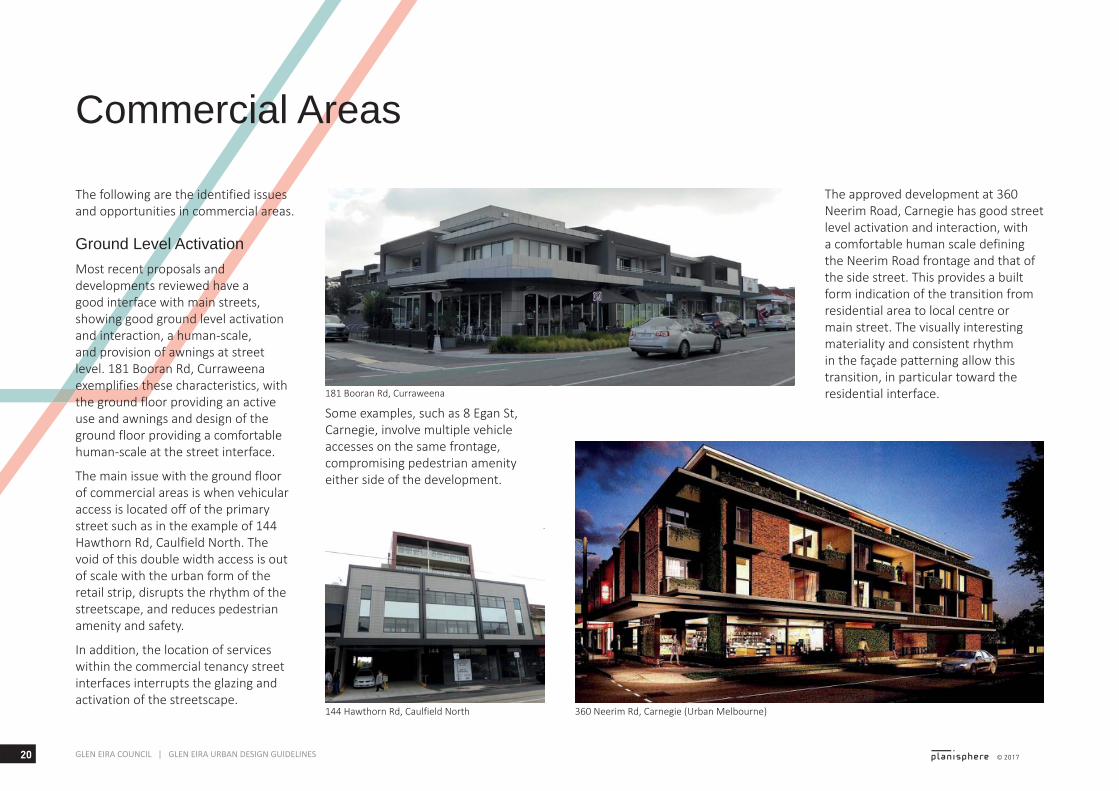
Ground Level ActivationMost recent proposals and developments reviewed have a good interface with main streets, showing good ground level activation and interaction, a human-scale, and provision of awnings at street level. 181 Booran Rd, Curraweena exemplifies these characteristics, with the ground floor providing an active use and awnings and design of the ground floor providing a comfortable human-scale at the street interface.
The main issue with the ground floor of commercial areas is when vehicular access is located off of the primary street such as in the example of 144 Hawthorn Rd, Caulfield North. The void of this double width access is out of scale with the urban form of the retail strip, disrupts the rhythm of the streetscape, and reduces pedestrian amenity and safety.
In addition, the location of services within the commercial tenancy street interfaces interrupts the glazing and activation of the streetscape.
Some examples, such as 8 Egan St, Carnegie, involve multiple vehicle accesses on the same frontage, compromising pedestrian amenity either side of the development.
The approved development at 360 Neerim Road, Carnegie has good street level activation and interaction, with a comfortable human scale defining the Neerim Road frontage and that of the side street. This provides a built form indication of the transition from residential area to local centre or main street. The visually interesting materiality and consistent rhythm in the façade patterning allow this transition, in particular toward the residential interface.181 Booran Rd, Curraweena
360 Neerim Rd, Carnegie (Urban Melbourne)144 Hawthorn Rd, Caulfield North
21© 2017 GLEN EIRA COUNCIL | GLEN EIRA URBAN DESIGN GUIDELINES
8 Egan St, Carnegie (Message Consultants)
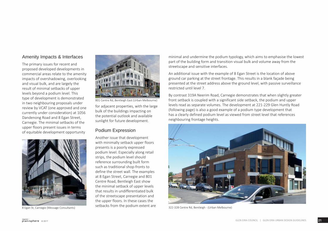
Amenity Impacts & InterfacesThe primary issues for recent and proposed developed developments in commercial areas relate to the amenity impacts of overshadowing, overlooking and visual bulk, and are largely the result of minimal setbacks of upper levels beyond a podium level. This type of development is demonstrated in two neighbouring proposals under review by VCAT (one approved and one currently under consideration) at 1056 Dandenong Road and 8 Egan Street, Carnegie. The minimal setbacks of the upper floors present issues in terms of equitable development opportunity
for adjacent properties, with the large bulk of the buildings impacting on the potential outlook and available sunlight for future development.
Podium ExpressionAnother issue that development with minimally setback upper floors presents is a poorly expressed podium level. Especially along retail strips, the podium level should reference surrounding built form such as traditional shop-fronts to define the street wall. The examples at 8 Egan Street, Carnegie and 801 Centre Road, Bentleigh East show the minimal setback of upper levels that results in undifferentiated bulk of the streetscape presentation and the upper floors. In these cases the setbacks from the podium extent are
minimal and undermine the podium typology, which aims to emphasise the lowest part of the building form and transition visual bulk and volume away from the streetscape and sensitive interfaces.
An additional issue with the example of 8 Egan Street is the location of above ground car parking at the street frontage. This results in a blank façade being presented at the street address above the ground level, with passive surveillance restricted until level 7.
By contrast 319A Neerim Road, Carnegie demonstrates that when slightly greater front setback is coupled with a significant side setback, the podium and upper levels read as separate volumes. The development at 221-229 Glen Huntly Road (following page) is also a good example of a podium type development that has a clearly defined podium level as viewed from street level that references neighbouring frontage heights.
801 Centre Rd, Bentleigh East (Urban Melbourne)
322-328 Centre Rd, Bentleigh - (Urban Melbourne)
22 © 2017GLEN EIRA COUNCIL | GLEN EIRA URBAN DESIGN GUIDELINES
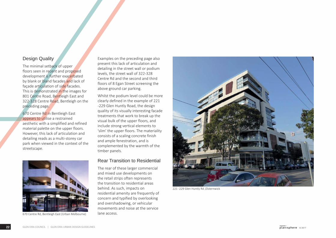
Design QualityThe minimal setback of upper floors seen in recent and proposed development is further exacerbated by blank or bland facades and lack of façade articulation of side facades. This is demonstrated in the images for 801 Centre Road, Bentleigh East and 322-328 Centre Road, Bentleigh on the preceding page.
670 Centre Rd in Bentleigh East appears to utilise a restrained aesthetic with a simplified and refined material palette on the upper floors. However, this lack of articulation and detailing reads as a multi-storey car park when viewed in the context of the streetscape.
221 -229 Glen Huntly Rd ,Elsternwick
670 Centre Rd, Bentleigh East (Urban Melbourne)
Examples on the preceding page also present this lack of articulation and detailing in the street wall or podium levels, the street wall of 322-328 Centre Rd and the second and third floors of 8 Egan Street screening the above ground car parking.
Whilst the podium level could be more clearly defined in the example of 221 -229 Glen Huntly Road, the design quality of its visually interesting facade treatments that work to break up the visual bulk of the upper floors, and include strong vertical elements to ‘slim’ the upper floors. The materiality consists of a scaling concrete finish and ample fenestration, and is complemented by the warmth of the timber panels.
Rear Transition to ResidentialThe rear of these larger commercial and mixed use developments on the retail strips often represents the transition to residential areas behind. As such, impacts on residential amenity are frequently of concern and typified by overlooking and overshadowing, or vehicular movements and noise at the service lane access.
23© 2017 GLEN EIRA COUNCIL | GLEN EIRA URBAN DESIGN GUIDELINES
The following issues and opportunities have been identified for residential areas.
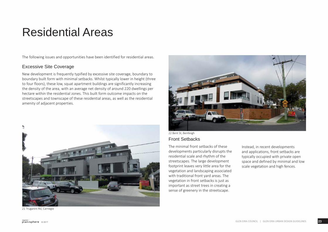
Excessive Site CoverageNew development is frequently typified by excessive site coverage, boundary to boundary built form with minimal setbacks. Whilst typically lower in height (three to four floors), these low, squat apartment buildings are significantly increasing the density of the area, with an average net density of around 220 dwellings per hectare within the residential zones. This built form outcome impacts on the streetscapes and townscape of these residential areas, as well as the residential amenity of adjacent properties.
21 Truganini Rd, Carnegie
22 Bent St, Bentleigh
Front SetbacksThe minimal front setbacks of these developments particularly disrupts the residential scale and rhythm of the streetscapes. The large development footprint leaves very little area for the vegetation and landscaping associated with traditional front yard areas. The vegetation in front setbacks is just as important as street trees in creating a sense of greenery in the streetscape.
Residential Areas
Instead, in recent developments and applications, front setbacks are typically occupied with private open space and defined by minimal and low scale vegetation and high fences.
24 © 2017GLEN EIRA COUNCIL | GLEN EIRA URBAN DESIGN GUIDELINES
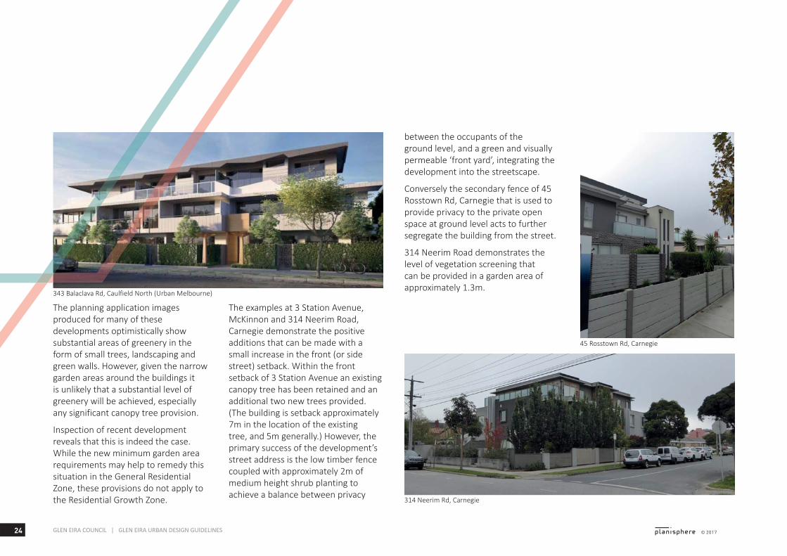
The planning application images produced for many of these developments optimistically show substantial areas of greenery in the form of small trees, landscaping and green walls. However, given the narrow garden areas around the buildings it is unlikely that a substantial level of greenery will be achieved, especially any significant canopy tree provision.
Inspection of recent development reveals that this is indeed the case. While the new minimum garden area requirements may help to remedy this situation in the General Residential Zone, these provisions do not apply to the Residential Growth Zone.
343 Balaclava Rd, Caulfield North (Urban Melbourne)
45 Rosstown Rd, Carnegie
314 Neerim Rd, Carnegie
The examples at 3 Station Avenue, McKinnon and 314 Neerim Road, Carnegie demonstrate the positive additions that can be made with a small increase in the front (or side street) setback. Within the front setback of 3 Station Avenue an existing canopy tree has been retained and an additional two new trees provided. (The building is setback approximately 7m in the location of the existing tree, and 5m generally.) However, the primary success of the development’s street address is the low timber fence coupled with approximately 2m of medium height shrub planting to achieve a balance between privacy
between the occupants of the ground level, and a green and visually permeable ‘front yard’, integrating the development into the streetscape.
Conversely the secondary fence of 45 Rosstown Rd, Carnegie that is used to provide privacy to the private open space at ground level acts to further segregate the building from the street.
314 Neerim Road demonstrates the level of vegetation screening that can be provided in a garden area of approximately 1.3m.
25© 2017 GLEN EIRA COUNCIL | GLEN EIRA URBAN DESIGN GUIDELINES
22 & 20 Station Ave, McKinnon
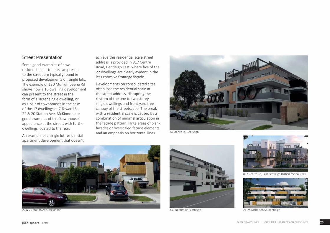
Street PresentationSome good examples of how residential apartments can present to the street are typically found in proposed developments on single lots. The example of 130 Murrumbeena Rd shows how a 16 dwelling development can present to the street in the form of a larger single dwelling, or as a pair of townhouses in the case of the 17 dwellings at 7 Toward St. 22 & 20 Station Ave, McKinnon are good examples of this ‘townhouse’ appearance at the street, with further dwellings located to the rear.
An example of a single lot residential apartment development that doesn’t
achieve this residential scale street address is provided in 817 Centre Road, Bentleigh East, where five of the 22 dwellings are clearly evident in the less cohesive frontage façade.
Developments on consolidated sites often lose the residential scale at the street address, disrupting the rhythm of the one to two storey single dwellings and front-yard tree canopy of the streetscape. The break with a residential scale is caused by a combination of minimal articulation in the facade pattern, large areas of blank facades or overscaled facade elements, and an emphasis on horizontal lines. 24 Mahvo St, Bentleigh
21-25 Nicholson St, Bentleigh339 Neerim Rd, Carnegie
817 Centre Rd, East Bentleigh (Urban Melbourne)
26 © 2017GLEN EIRA COUNCIL | GLEN EIRA URBAN DESIGN GUIDELINES
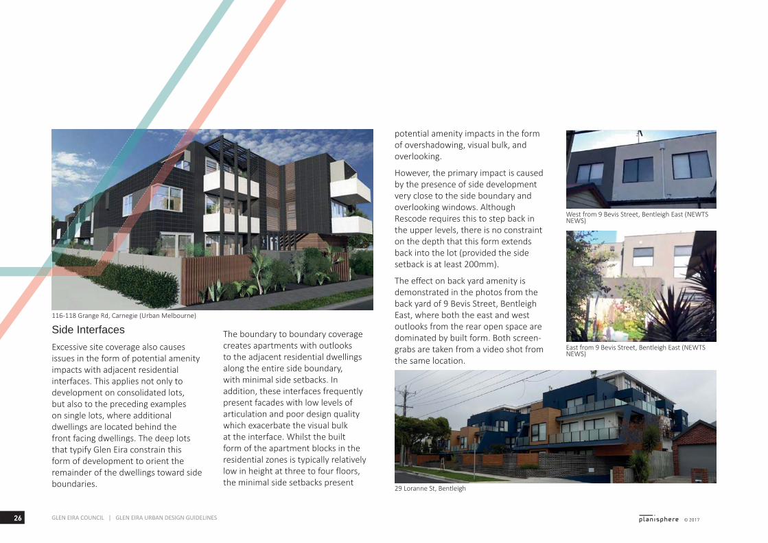
Side InterfacesExcessive site coverage also causes issues in the form of potential amenity impacts with adjacent residential interfaces. This applies not only to development on consolidated lots, but also to the preceding examples on single lots, where additional dwellings are located behind the front facing dwellings. The deep lots that typify Glen Eira constrain this form of development to orient the remainder of the dwellings toward side boundaries.
potential amenity impacts in the form of overshadowing, visual bulk, and overlooking.
However, the primary impact is caused by the presence of side development very close to the side boundary and overlooking windows. Although Rescode requires this to step back in the upper levels, there is no constraint on the depth that this form extends back into the lot (provided the side setback is at least 200mm).
The effect on back yard amenity is demonstrated in the photos from the back yard of 9 Bevis Street, Bentleigh East, where both the east and west outlooks from the rear open space are dominated by built form. Both screen-grabs are taken from a video shot from the same location.
29 Loranne St, Bentleigh
116-118 Grange Rd, Carnegie (Urban Melbourne)
East from 9 Bevis Street, Bentleigh East (NEWTS NEWS)
West from 9 Bevis Street, Bentleigh East (NEWTS NEWS)
The boundary to boundary coverage creates apartments with outlooks to the adjacent residential dwellings along the entire side boundary, with minimal side setbacks. In addition, these interfaces frequently present facades with low levels of articulation and poor design quality which exacerbate the visual bulk at the interface. Whilst the built form of the apartment blocks in the residential zones is typically relatively low in height at three to four floors, the minimal side setbacks present
27© 2017 GLEN EIRA COUNCIL | GLEN EIRA URBAN DESIGN GUIDELINES
15 Truganini Rd, Carnegie 10 Station Ave, McKinnon
339 Neerim Rd, Carnegie1 Faulkner St, Bentleigh 22 Bent St Bentleigh
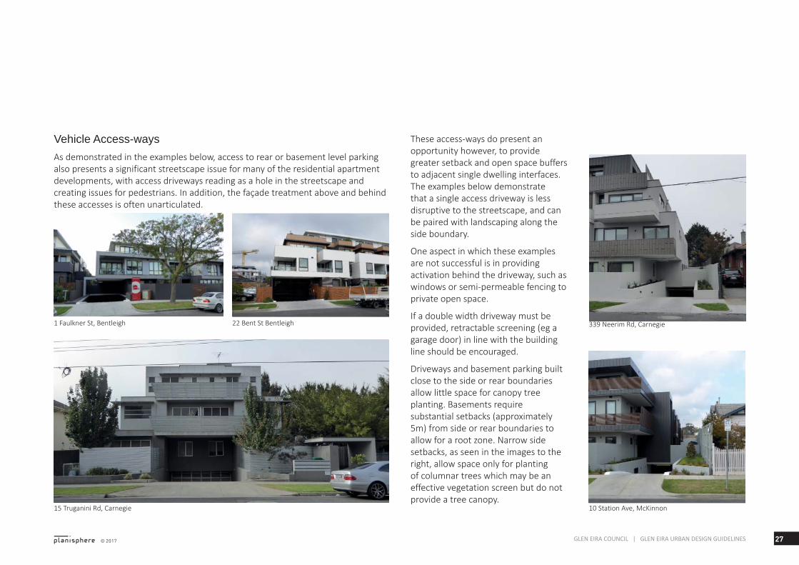
Vehicle Access-waysAs demonstrated in the examples below, access to rear or basement level parking also presents a significant streetscape issue for many of the residential apartment developments, with access driveways reading as a hole in the streetscape and creating issues for pedestrians. In addition, the façade treatment above and behind these accesses is often unarticulated.
These access-ways do present an opportunity however, to provide greater setback and open space buffers to adjacent single dwelling interfaces. The examples below demonstrate that a single access driveway is less disruptive to the streetscape, and can be paired with landscaping along the side boundary.
One aspect in which these examples are not successful is in providing activation behind the driveway, such as windows or semi-permeable fencing to private open space.
If a double width driveway must be provided, retractable screening (eg a garage door) in line with the building line should be encouraged.
Driveways and basement parking built close to the side or rear boundaries allow little space for canopy tree planting. Basements require substantial setbacks (approximately 5m) from side or rear boundaries to allow for a root zone. Narrow side setbacks, as seen in the images to the right, allow space only for planting of columnar trees which may be an effective vegetation screen but do not provide a tree canopy.

28 © 2017GLEN EIRA COUNCIL | GLEN EIRA URBAN DESIGN GUIDELINES
29GLEN EIRA COUNCIL | GLEN EIRA URBAN DESIGN GUIDELINES
Review of Built Form & Design Controls
5

30 © 2017GLEN EIRA COUNCIL | GLEN EIRA URBAN DESIGN GUIDELINES
Existing Controls for Glen Eira’s Activity Centres
OverviewThe existing built form and design controls for Glen Eira’s activity centres have been reviewed to determine how well they are responding to development issues and opportunities.
This review includes the Commercial 1 Zone, the Residential Growth Zone and the General Residential Zone, as specified in the project brief.
Local Planning Policy Council’s Municipal Strategic Statement and Local Planning Policies of the Glen Eira Planning Scheme provide strategic direction for development within activity centres:
▪ Clause 21.03: Vision – Strategic Framework
▪ Clause 21.04: Housing and Residential Development
▪ Clause 21.06: Business
▪ Clause 22.05: Urban Villages Policy.
These policies are implemented through the detailed design and development requirements of zones and overlay controls.
Commercial ZonesCommercial 1 Zone
The Commercial 1 Zone (C1Z) applies to the core retail and commercial areas within Glen Eira’s Activity Centres.
The purpose of the C1Z is:
▪ To create vibrant mixed use commercial centres for retail, office, business, entertainment and community uses.
▪ To provide for residential uses at densities complementary to the role and scale of the commercial centre.
The C1Z does not include detailed urban design requirements, or specify building heights and setbacks.
Decision guidelines include:
▪ Reference to State and Local Policy and the interface with adjoining zones, particularly residential
▪ Broad requirements relating to streetscape appearance and pedestrian amenity.
▪ Consideration of the overlooking and overshadowing as a result of building or works affecting adjoining land in a General Residential Zone, Neighbourhood Residential Zone or Residential Growth Zone.
However, these decision guidelines are not supported by specific built form or design controls. The zone provides only broad and high-level directions relating to urban design and would not in itself address the development issues identified in this study
Design & Development Overlays
The Design and Development Overlay (DDO) has recently been applied to activity centres: DDO8 has been applied to the Bentleigh Activity Centre and DDO9 to the Carnegie Activity Centre.
The purpose of the DDO is:
To identify areas which are affected by specific requirements relating to the design and built form of new development.
The objectives of DDO8 and DDO9 include:
• To ensure that development makes a positive architectural contribution to the low scale, retail village.
• To ensure that development along any residential interface be sympathetic to the scale and amenity of the residential area.
• To ensure that development is designed to maintain safe and efficient vehicle movements.
The overlays set out detailed built form requirements, including:
▪ Buildings should be of a high architectural and urban design quality and make a positive contribution to the activity centre and surrounding streetscapes.
▪ Buildings should be designed to respect the existing character and scale of streetscapes and should facilitate a continuous active and vibrant frontage at street level, including weather protection along designated pedestrian links.

31© 2017 GLEN EIRA COUNCIL | GLEN EIRA URBAN DESIGN GUIDELINES
▪ Architectural articulation of facades should minimise visual bulk throught the use of upper level setbacks and an appropriate materials palette.
▪ Car spaces should not be provided at ground level, exposed to the public realm.
▪ Residential development should be designed with pedestrian access directly from the street.
Maximum building heights are specified for each precent within the activity centres, with some expressed as mandatory controls.
Decision guildienes relate to how the development will integrate with streetscape character, impacts on adjoining heritage sites and the protection of amenity of adjoining residential sites, including prevention of overlooking.
Residential ZonesThe Residential Growth Zone and General Residential Zone have been applied around activity centres.
These zone controls work in tandem with the Particular Provisions of the Planning Scheme:
▪ Residential development up to four storeys must meet the requirements of ResCode, which are contained in Clauses 54 and 55 of the Glen Eira Planning Scheme. Several ResCode standards, including ground level setbacks, open space, landscaping and walls on boundaries, can be varied through a schedule to the zone to suit local circumstances.
▪ An apartment development of five or more storeys must meet the requirements of Clause 58 - Apartment standards.
Residential Growth Zone
The Residential Growth Zone (RGZ) is applied to residential land immediately adjoining the C1Z land in some of Glen Eira’s activity centres.
The purpose of the RGZ is:
• To provide housing at increased densities in buildings up to and including four storey buildings.
• To encourage a diversity of housing types in locations offering good access to services and transport including activity centres and town centres.
• To encourage a scale of development that provides a transition between areas of more intensive use and development and other residential areas.
• To allow educational, recreational, religious, community and a limited range of other non-residential uses to serve local community needs in appropriate locations.
There are two schedules to the RGZ in Glen Eira:
Schedule 1 to the RGZ (Urban villages) specifies a mandatory height of 13.5m and has no ResCode variations.
Schedule 2 to the RGZ (Strategic development sites) specifies a discretionary height of 13.5m and has no ResCode variations.
General Residential Zone
The General Residential Zone (GRZ) applies to residential development around Glen Eira’s activity centres, at the interface with the lower-scale and density Neighbourhood Residential Zoned land.
The purpose of the GRZ is:
• To encourage development that respects the neighbourhood character of the area.
• To encourage a diversity of housing types and housing growth particularly in locations offering good access to services and transport.
▪ To allow educational, recreational, religious, community and a limited range of other non-residential uses to serve local community needs in appropriate locations.
Recent changes the to GRZ have seen the introduction of a new garden space requirement that must be provided as a minimum percentage of site area, at ground level:
▪ 400 - 500m2 25% of site area
▪ 501 - 650 square metres 30% of
32 © 2017GLEN EIRA COUNCIL | GLEN EIRA URBAN DESIGN GUIDELINES
site area
▪ Above 650m2 - 35% of site area.
The garden area must be a minimum of 1 metre in width and can be calculated with areas such as; lawns, open entertaining areas, garden beds, swimming pools and tennis courts. The garden area applies to any lot over 400m2 and does not include driveways or roofed areas.
There is also a new requirement for relevant neighbourhood character objectives to be specified in the schedule to the residential zones. This will allow Council to specify the key requirements for the areas to which each schedule applies.
There are three schedules to the GRZ in Glen Eira:
Schedule 1 to the GRZ (Neighbourhood centre areas) specifies a mandatory height of 10.5m and has no ResCode variations.
Schedule 2 to the GRZ (Tram, routes & main roads, residential transition areas) specifies a mandatory height of 10.5m as well as variation to the side and rear setbacks requirements:
▪ First storey (ground level or basement) rear setback – 4 metres from a property in the Neighbourhood Residential Zone.
▪ Second storey rear setback – 5.5 metres from a property in the Neighbourhood Residential Zone.
▪ Third storey rear setback – 11.5 metres from a property in the Neighbourhood Residential Zone.
Schedule 3 to the GRZ (Infill residential development sites) has the same specifications as GRZ2.
Particular ProvisionsClause 55: Two or more dwellings - ‘ResCode’
The particular provisions relating to residential development of two or more dwellings and under four storeys are at Clause 55 (ResCode) and include the objectives:
• To achieve residential development that respects the existing neighbourhood character or which contributes to a preferred neighbourhood character.
• To encourage residential development that provides reasonable standards of amenity for existing and new residents.
• To encourage residential development that is responsive to the site and the neighbourhood.
ResCode includes detailed design objectives and standards, at Clauses 55.01 through to 55.07. These relate to the key design issues of: neighbourhood and site description and design response; neighbourhood character and infrastructure; site layout and building massing; amenity impacts; on-site amenity and facilities; detailed design; and apartment developments.
New developments must meet all applicable objectives and should meet all applicable standards. As noted, some of the objectives and standards may be modified through a schedule to the zone to provide specific design outcomes in nominated locations.
Clause 58: Apartment developments - over 5 storeys
The recently introduced Clause 58 - Apartment developments - relates to
apartment developments of 5 or more storeys in the GRZ or RGZ, and any apartment development in the C1Z.
Clause 58 implements the new State Government Better Apartment Design Standards (Department of Environment, Land, Water and Planning, 2017).
The objectives standards address detailed design issues of both internal amenity and response to urban context.
Clause 58 introduces requirements relating to:
▪ Urban context
▪ Site layout
▪ Amenity impacts
▪ Design design
▪ Internal amenity.
State Government Design Guidelines State Planning Policy, at Clause 15.01-1 Urban Design, requires that these guidelines are referenced in considering the design of buildings in activity centres:
33© 2017 GLEN EIRA COUNCIL | GLEN EIRA URBAN DESIGN GUIDELINES
▪ Design Guidelines for Higher Density Residential Development (Department of Sustainability and Environment, 2004)
▪ Activity Centre Design Guidelines (Department of Sustainability and Environment, 2005).
Guidelines for Higher Density Residential Development
The Guidelines for Higher Density Residential Development apply to residential buildings of four or more storeys, and relate to issues such as height, neighbourhood character, street setback, open space, overlooking and overshadowing.
Where planning controls allow higher density housing, the guidelines assist designers to prepare development applications that respond to the local urban context and meet the design objectives. The guidelines also help council planners when assessing development applications.
The guidelines are structured around under six elements of design consideration:
▪ Urban context
▪ Building envelope
▪ Street pattern and street edge quality
▪ Circulation and services
▪ Building layout and design
▪ Open space and landscape design.
Activity Centre Design Guidelines
The Activity Centre Design Guidelines for activity centres provide general design advice on various aspects of best-practice urban design for activity centres.
The guidelines are structured under eight elements of design consideration:
▪ Urban structure
▪ Stations and interchanges
▪ Street design
▪ Public spaces
▪ Building design
▪ Malls and large stores
▪ Higher density housing
▪ Car parking.
How effective are the current controls?The review of development issues and opportunities in Glen Eira in Chapter 3 has shown that the current planning policies and controls are lacking in terms of achieving desired design outcomes for Council’s activity centres.
Key issues that a review of planning policies and controls should address are:
▪ Setting maximum building heights and setbacks from the street or adjoining sites
▪ Ensuring a transitional building form to adjoining residential or lower-scale interfaces
▪ Managing amenity issues at the interface with adjoining residential sites, including overlooking, overshadowing and visual bulk
▪ Activation of the lower building levels, as appropriate to a retail/commercial or residential streetscape
▪ Ensuring a high standard of overall design quality, with improved outcomes in terms of design detail,
materials and articulation
▪ Improved design of basement carparking, including setting a minimum footprint to allow space for tree planting and design of the entrance so that it does not detract from the streetscape
▪ For higher scale mixed use buildings, clear expression of a podium base and tower form above
▪ In residential areas, ensuring adequate space is retained for garden areas and landscaping, including canopy trees; this is a particular issue in the General Residential Zoned areas
▪ Providing a diversity of housing types in new residential development, including accommodation for singles, larger household groups, the elderly and affordable housing.
34 © 2017GLEN EIRA COUNCIL | GLEN EIRA URBAN DESIGN GUIDELINES
Review of Best Practice Development Guidelines
OverviewA selection of best practice development guidelines have been reviewed to assist in the preparation of development guidelines for Glen Eira’s activity centres.
This review has illustrated how other municipal areas are managing design issues in residential and commercial development within and around activity centres. It provides useful references for the next stage of the project, in which detailed guidelines will be prepared for Glen Eira, and ultimately translated into Planning Scheme controls.
Best practice design guidelines - discussion
Most examples of Urban Design Guidelines are specific to a certain geographical area and/or an urban form or typology, and address particular issues. They are therefore specific in their recommendations and implementation.
Many of the guidelines are included in the planning scheme as a reference document, such that they must be considered when assessing relevant
planning permit applications. Some of the guidelines have also been translated into planning scheme controls, such as the Design and Development Overlay or variations to residential zone schedules.
Several of the guidelines are of particular relevance to this document. Firstly, the Dandenong Road UDF includes detailed recommendations pertaining to the transition of development scale and intensity from designated strategic development areas on Dandenong Road, to existing residential streets behind.
The Banyule Tree Planting Zone Guidelines outline the techniques required to ensure greater provision of canopy trees.
And lastly, the City of Darebin Residential Built Form Guidelines are an example of detailed design guidelines relating to a very similar set of circumstances and issues to those found in the residential areas of Glen Eira’s activity centres.
For this reason these guidelines have been discussed in greater detail.
Commercial City of Whitehorse - Neighbourhood Activity Centre Urban Design Guidelines (Planisphere)
These guidelines consider factors such as availability and proximity to existing facilities, development opportunities and constraints, and the appropriate scale of development, for each of the Neighbourhood Activity Centres to determine the form of development that may be appropriate for the type of centre.
General design guidelines apply to each of the 60 centres identified across the municipality as part of the study. Detailed building heights and setbacks, as well as design objectives and built form guidelines, are provided for five different categories of centre:
▪ Small-medium local service centres, on a standard width road
▪ Large sized centres on a standard width road
▪ Small-medium local service centres on a wide main road
▪ Large sized centres on a wide main road
▪ Large, car based centres on a wide main road.
The guidelines are included in the Planning Scheme as a Reference Document and used when assessing relevant planning permit applications.
This study is a good example of how to apply design guidelines to different built form typologies that exist across an entire municipal area.
City of Stonnington - Dandenong Road Urban Design Framework (David Lock Associates)
The Framework relates to a very specific issue and area, namely the height of buildings north of Dandenong Road, between Tooronga Rd and Bates St, Stonnington. This area is directly opposite Caulfield Junction within Glen Eira.
The Framework recommends height limits to the Dandenong Rd frontage, including a preferred street wall height. It notes the emerging character of Dandenong Road of 6-7 storey buildings with the top floor setback. Therefore, the guidelines include a discretionary height limit of 25m with a preferred street wall height of 20m
35© 2017 GLEN EIRA COUNCIL | GLEN EIRA URBAN DESIGN GUIDELINES
to reinforce this character.
The Framework notes that “the width of Dandenong Road means that development which complies with the guidelines will not result in an uncomfortable degree of enclosure. Indeed, taller buildings are needed to have sufficient presence to reduce the visual dominance of the road”.
The Framework also proposes a 3-storey residential development at the interface with residential street frontages, including:
▪ 3m front setback with soft landscaping and canopy trees
▪ Setback of third level
▪ Modulation of the built form to reflect the rhythm of existing residential development in the street. “For example, development could include recessed sections between pairs of apartments or townhouses to mimic the gaps between detached houses.”
▪ Front fences up to 1.5m high from footpath level
▪ Individual entries to ground floor dwellings.
These recommendations are provided to ensure a residential scale is retained in these streets. Whilst they promote townhouse developments fronting these streets, the emphasis is on the appearance and function of dwellings fronting the street rather than the development typology, meaning that apartments could still be provided in accordance with the guidelines.
Recommendations are also provided for interfaces with residential lots or laneways.
The provisions of the Framework have been translated into the Stonnington Planning Scheme through the DDO.
City of Banyule - Greensborough Activity Centre Design Guidelines (David Lock Associates)
These Guidelines apply to Precincts 2, 5 & 6 within the Greensborough Activity Centre Zone and address building heights and massing, views and vistas, and setbacks and landscaping.
The Guidelines set out built form parameters for different sub-precincts. They aim to balance the intensification of built form with retaining a human
scale at the street level to enhance the pedestrian experience and to protect existing views and vistas.
Street setbacks and landscaping are recommended based on a hierarchy of road types, with setback increasing as the order of the road descends. Minimum setbacks are applied, with increases for existing vegetation.
The Guidelines have been translated into the Banyule Planning Scheme through the detailed requirements of the ACZ schedule, and are also included as a Reference Document.
City Of Darebin - High Street Precinct Guidelines (DLA & Planisphere)
These Guidelines set out preferred outcomes, key objectives and a vision for different precincts along HIgh Street. The Guidelines set out very specific built form parameters, including building heights and setbacks to respond to the local context.
This includes appropriate building scale at the street frontage and upper level setbacks to retain streetscape character. Heights and setbacks at different residential interface scenarios
are also set out so that overlooking, overshadowing or visual bulk can be avoided at the commercial-residential transition.
The Guidelines have been translated into the Darebin Planning Scheme through the DDO.
ResidentialCity Of Darebin - Residential Built Form Guidelines
These Guidelines respond to the increasing pressure for apartment development in Darebin’s residential areas, to guide the built form of higher density residential development. The Guidelines are directed by principles derived from the Urban Design Charter for Victoria.
The Guidelines are based around two typologies: a Garden Apartment typology, and an alternative Urban Apartment typology that responds to a more urban road character of some precincts.
General design guidelines are set out, and relate to the principles of the Urban Design Charter, providing
36 © 2017GLEN EIRA COUNCIL | GLEN EIRA URBAN DESIGN GUIDELINES
objectives and a set of specific guidelines for each principle.
The design objectives of these Guidelines are highly relevant to the current development issues in Glen Eira, and include:
▪ To ensure development contributes to a high quality pedestrian environment and increases activation of the public realm
▪ To facilitate the consolidation of lots to increase street frontage width
▪ To maximise the development of the front portion of the lot with front and rear facing dwellings
▪ To discourage side-facing dwellings, due to their potential for reduced amenity outcomes
▪ To match the layout of the garden apartment typology, where it exists (or has the potential to) on the boundary of adjacent lots
▪ To provide side setbacks, towards the rear of the lot, with adequate width to permit canopy trees, creating a garden setting for dwellings
▪ To provide adequate separation between dwellings within the lot, avoiding reliance on screening to provide privacy
▪ To allow potential for additional dwellings to the rear of deeper lots, provided that building separation requirements can be met within the lot
▪ To recognise the potential for a cumulative adverse impact of higher density development along a corridor, and propose rear setbacks to sensitive rear interfaces that seek to mitigate this effect
▪ To balance considerations of potential development yield with internal amenity
▪ To consider the amenity of adjacent lots, in terms of primary dwelling outlooks and private open space, where they are considered to have a lower propensity for redevelopment
▪ To accommodate potential mixed uses at ground floor level in the Urban Apartment Building typology.
The Garden Apartment typology has been applied within the RGZ through
changes to the schedule: additional requirements for ResCode standards of front setbacks, site coverage, permeability and landscaping have been applied. The DDO also applies to RGZ areas around activity centres in order to encourage higher density housing of an appropriate standard, and to manage sensitive interface conditions.
Maroondah City Council - Ringwood Transit City North West Residential Precinct Plan (Planisphere)
This Precinct Plan follows on from the Ringwood Transit City Urban Design Masterplan 2004, to guide future residential development in the Precinct. The plan includes general design guidelines for a range of design elements, with objectives and design responses provided for each element.
These guidelines include built form parameters in the form of interface typologies, and also preferred character including height, setback, balconies, corner elements and materials. They have been translated into a DDO.
Bayside City Council - Small Neighbourhood Activity Centres Design Assessment & Guidelines
These Guidelines consider detailed design responses for small Neighbourhood Activity Centres (NACs) and aim to address different contextual issues of coastal settings, the residential hinterland, public transport corridors and main roads.
The Guidelines consider the specific street context and interface scenarios of the municipality’s NACs by way of building typologies.
Each centre is assessed in terms its capacity for change, considering:
▪ The designation in the Bayside Activity Centre hierarchy
▪ The ‘type’ of centre, having regard to its arrangement as a one or two sided strip centre
▪ The ‘setting’, having regard to the influence of surrounding residential neighbourhood qualities, public transport provision or main road or coastal address.
The capacity for change of each centre accords to one of three design responses which outline a
37© 2017 GLEN EIRA COUNCIL | GLEN EIRA URBAN DESIGN GUIDELINES
recommended building envelope.
Essentially, the design responses are identical setting out a maximum height and front and rear setbacks, with an additional floor recommended for each increase in level of capacity to change.
Banyule City Council - Tree Planting Zone Guidelines
Banyule City Council have conducted extensive research on ways in which the municipality’s tree canopy can be retained and extended in residential development. A key aspect of this aim has been to develop these Tree Planing Zone Guidelines to ensure that trees are retained, or can grow after a site has been developed.
The Guidelines set out a required ‘Tree Planting Zone’ to be provided at ground level to reduce the potential conflicts between trees and buildings.
A typical requirement is that one large to medium tree should be provided for every 400m² of site area, with a preference for large trees. This may include existing trees worthy of retention, and at least one of the large trees provided in the front setback.
The Guidelines have been implemented through the Planning Scheme as a Residential Neighbourhood Character Policy (Clause 22.02), which applies to all development in the Neighbourhood Residential Zone, General Residential Zone, Rural Conservation Zone, Low Density Residential Zone, and Precinct 5 of Schedule 1 to the Activity Centre Zone.
The GRZ Schedule 2 (Incremental areas) has been amended to require one canopy tree per 400m2 of site area, including 1 large tree in the front setback, and to limit site coverage to 40% to allow adequate space for landscaping.
Opportunities for Glen Eira’s Activity CentresThis review of approaches to commercial and residential design controls in other municipalities’ activity centres has shown that there is a range of possibilities to manage development outcomes in Glen Eirla.
Approaches to statutory implementation through the Glen Eira Planning Scheme could include:
▪ Overarching design objectives set out in an updated Local Policy, as well detailed objectives relating to a specific location or design issue
▪ Additional ResCode requirements included in the schedule to the RGZ or GRZ, relating to building heights, ground level setbacks, landscaping (including provision of canopy trees), site coverage, permeability and front fence height.
▪ Design objectives included in each schedule to the residential zones which set out the preferred future character.
▪ Application of the DDO to commercial or residential areas
within an activity centre, or its immediate surrounds where higher density housing is to be directed, which could address:
- Detailed built form parameters, including heights, setbacks, residential interface treatments
- Design of basement carparks and ground level streetscape integration and activation
- Detailed requirements for a transitional building form to adjoining residential or lower-scale interfaces and other means to manage residential amenity issues
- Ensuring a high standard of overall design quality, with improved outcomes in terms of design detail, materials and articulation
- For higher scale mixed use buildings, clear expression of a podium base and tower form above
- Integration of community benefit outcomes within higher scale/density development.
38 © 2017GLEN EIRA COUNCIL | GLEN EIRA URBAN DESIGN GUIDELINES