gns unece 60th working party geneva 2-11-2016 v4 · pdf fileongoing bilateral expert contacts...
TRANSCRIPT
Good Navigation Status
2nd of November, Geneva
UN‐ECE 60th Working Party on IWT
1

To substantiate Article 15 §3.(b) of TEN‐T Guidelines (Reg.1315/2013) as regards Good Navigation Status:
Member States shall ensure that on the Comprehensive Network“Rivers, canals and lakes are maintained so as to preserve Good Navigation Status while respecting the applicable environmental law”
Article 38: “For inland navigation infrastructure within the TEN‐T core network, Good Navigation Status has to be achieved (and thereafter preserved) by 31 December 2030.”
2
Background and purpose of GNS study

Entire TEN‐T inland waterway network– Not only core network
corridors– CEMT ≥IV waterways– Including (isolated) inland
waterways in Sweden, Finland, Lithuania, Italy, Portugal and Spain
– Good Practice also of interest for CEMT <IV waterways and non‐EU countries
3
Background and purpose of GNS study
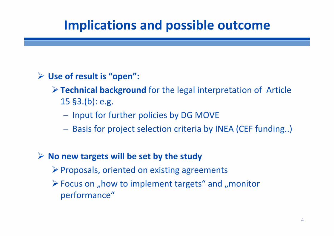
Use of result is “open”:Technical background for the legal interpretation of Article 15 §3.(b): e.g. Input for further policies by DG MOVE Basis for project selection criteria by INEA (CEF funding..)
No new targets will be set by the studyProposals, oriented on existing agreements Focus on „how to implement targets“ and „monitorperformance“
4
Implications and possible outcome
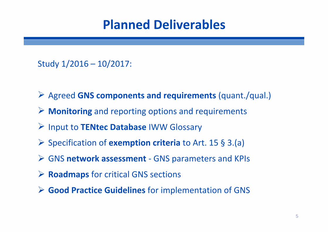
Study 1/2016 – 10/2017:
Agreed GNS components and requirements (quant./qual.)
Monitoring and reporting options and requirements
Input to TENtec Database IWW Glossary
Specification of exemption criteria to Art. 15 § 3.(a)
GNS network assessment ‐ GNS parameters and KPIs
Roadmaps for critical GNS sections
Good Practice Guidelines for implementation of GNS
5
Planned Deliverables
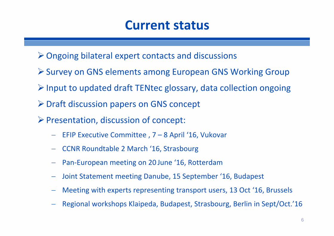
Ongoing bilateral expert contacts and discussions
Survey on GNS elements among European GNS Working Group
Input to updated draft TENtec glossary, data collection ongoing
Draft discussion papers on GNS concept
Presentation, discussion of concept: EFIP Executive Committee , 7 – 8 April ‘16, Vukovar
CCNR Roundtable 2 March ‘16, Strasbourg
Pan‐European meeting on 20 June ‘16, Rotterdam
Joint Statement meeting Danube, 15 September ‘16, Budapest
Meeting with experts representing transport users, 13 Oct ‘16, Brussels
Regional workshops Klaipeda, Budapest, Strasbourg, Berlin in Sept/Oct.’16
6
Current status

Purpose: to keep track of work and exchange feedback, discuss intermediate results
Members: o Experts from river commissions: CCNR, DC, MC, SCo Experts from national and regional waterway managers
and ministries of transport o Experts from the European Commission o Experts from IWT industryo Other experts….
Method: 3 pan European meetings (2016 – 2017), regional workshops, dedicated meetings and/or surveys 7
The GNS Working Group
8
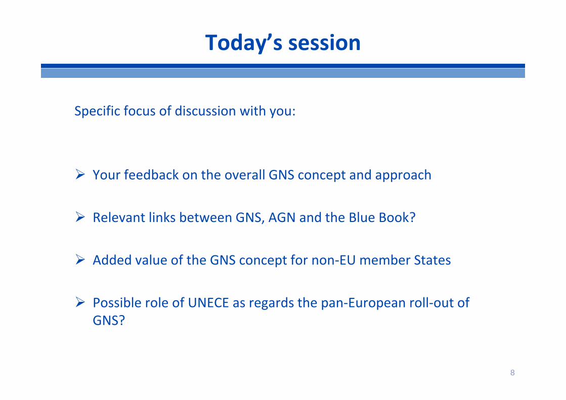
Today’s session
Specific focus of discussion with you:
Your feedback on the overall GNS concept and approach
Relevant links between GNS, AGN and the Blue Book?
Added value of the GNS concept for non‐EU member States
Possible role of UNECE as regards the pan‐European roll‐out of GNS?

9
What is important for Good Navigation Status?– Reliability and predictability of transport– Maximising payload on board, economies of scale– Minimising waiting times– Sustainability – Safety
Article 15 b: “Rivers, canals and lakes are maintained so as to preserve good navigation status” key focus physical waterway infrastructure
Background of GNS concept

10
“Good Navigation Status (GNS) means the state of the inland navigation transport network, which enables efficient, reliable and safe navigation for users by ensuring minimum waterway parameter values and levels of service.”
Moreover, GNS is to be achieved considering the wider socioeconomic and environmental sustainability of waterway management.
Proposed definition of “Good Navigation Status”
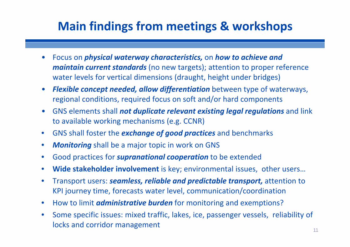
• Focus on physical waterway characteristics, on how to achieve and maintain current standards (no new targets); attention to proper reference water levels for vertical dimensions (draught, height under bridges)
• Flexible concept needed, allow differentiation between type of waterways, regional conditions, required focus on soft and/or hard components
• GNS elements shall not duplicate relevant existing legal regulations and link to available working mechanisms (e.g. CCNR)
• GNS shall foster the exchange of good practices and benchmarks• Monitoring shall be a major topic in work on GNS• Good practices for supranational cooperation to be extended• Wide stakeholder involvement is key; environmental issues, other users…• Transport users: seamless, reliable and predictable transport, attention to
KPI journey time, forecasts water level, communication/coordination• How to limit administrative burden for monitoring and exemptions?• Some specific issues: mixed traffic, lakes, ice, passenger vessels, reliability of
locks and corridor management11
Main findings from meetings & workshops
12
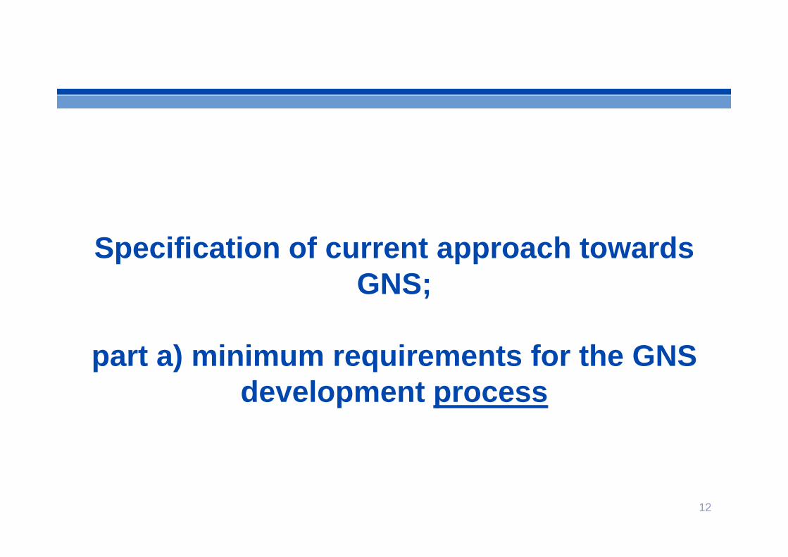
Specification of current approach towards GNS;
part a) minimum requirements for the GNS development process
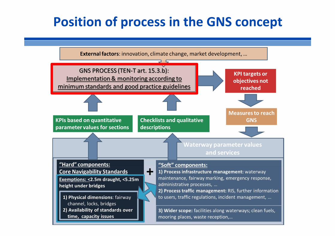
Position of process in the GNS concept
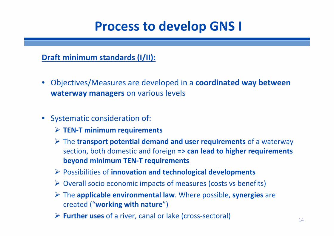
14
Draft minimum standards (I/II):
• Objectives/Measures are developed in a coordinated way between waterway managers on various levels
• Systematic consideration of: TEN‐T minimum requirements The transport potential demand and user requirements of a waterway
section, both domestic and foreign => can lead to higher requirements beyond minimum TEN‐T requirements
Possibilities of innovation and technological developments Overall socio economic impacts of measures (costs vs benefits) The applicable environmental law. Where possible, synergies are
created (“working with nature”) Further uses of a river, canal or lake (cross‐sectoral)
Process to develop GNS I
15
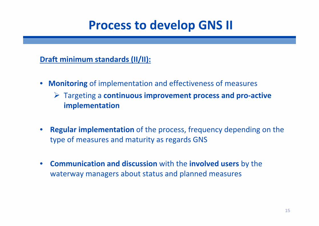
Draft minimum standards (II/II):
• Monitoring of implementation and effectiveness of measures Targeting a continuous improvement process and pro‐active
implementation
• Regular implementation of the process, frequency depending on the type of measures and maturity as regards GNS
• Communication and discussion with the involved users by the waterway managers about status and planned measures
Process to develop GNS II
16
part b) KPIs and monitoring
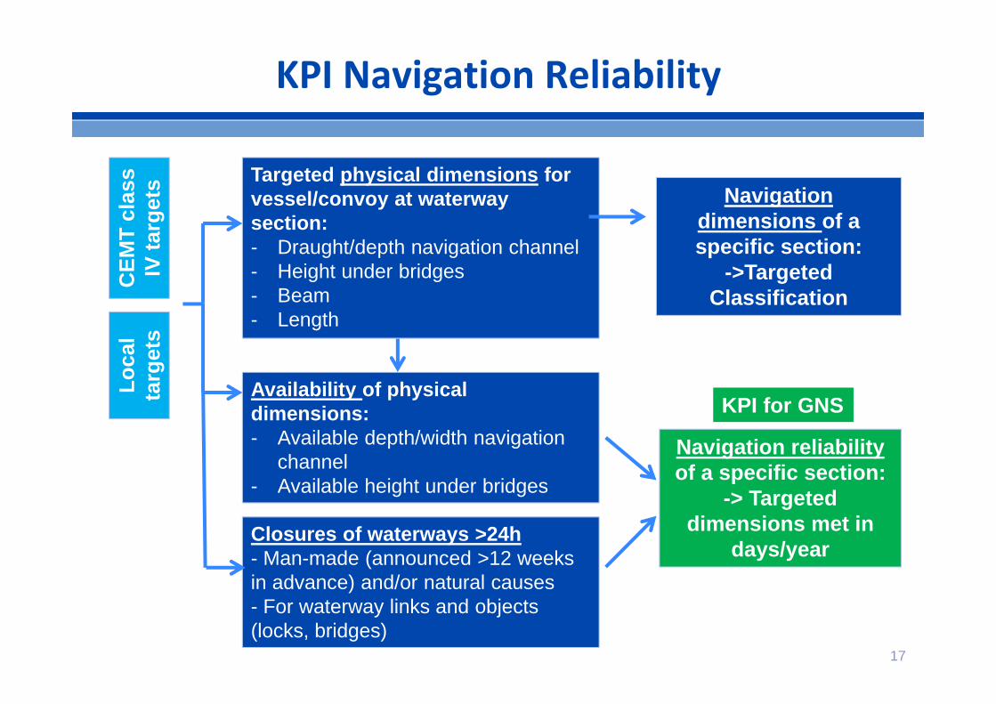
KPI Navigation Reliability
Navigation reliability of a specific section:
-> Targeted dimensions met in
days/year
Targeted physical dimensions for vessel/convoy at waterwaysection:- Draught/depth navigation channel - Height under bridges- Beam- Length
Availability of physical dimensions:- Available depth/width navigation
channel- Available height under bridges
Closures of waterways >24h- Man-made (announced >12 weeks in advance) and/or natural causes - For waterway links and objects (locks, bridges)
Navigation dimensions of a specific section:
->Targeted Classification
CEM
T cl
ass
IV ta
rget
s
KPI for GNS
Loca
lta
rget
s
17
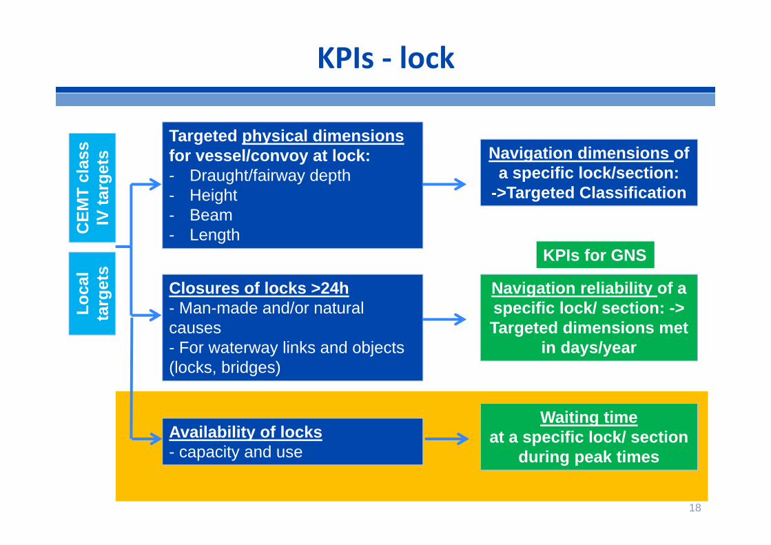
KPIs ‐ lock
Navigation reliability of a specific lock/ section: -> Targeted dimensions met
in days/year
Targeted physical dimensionsfor vessel/convoy at lock:- Draught/fairway depth- Height- Beam- Length
Closures of locks >24h- Man-made and/or natural causes - For waterway links and objects (locks, bridges)
Navigation dimensions of a specific lock/section:
->Targeted Classification
Availability of locks- capacity and use
Waiting timeat a specific lock/ section
during peak times
CEM
T cl
ass
IV ta
rget
sLo
cal
targ
ets
KPIs for GNS
18
19
part c) Exemption process and criteria

20
Article 15.3 (a):rivers, canals and lakes comply with the minimum requirements for class IV waterways as laid down in the new classification of inland waterways established by the European Conference of Ministers of Transport (ECMT) and that there is continuous bridge clearance, without prejudice to Articles 35 and 36 of this Regulation.At the request of a Member State, in duly justified cases, exemptions shall be granted by the Commission from the minimum requirements on draught (less than 2,50 m) and on minimum height under bridges (less than 5,25 m);
Understanding of Article 15.3 (a)

21
First list of proposed topics for exemption criteria from regional workshops:
– local conditions (hydrology, hydro‐morphology, further uses of a river..)
– extreme weather events (floods,…)– environmental requirements (e.g. WFD) – benefit/cost ratio less than 1– cultural heritage
Mainly relevant for free‐flowing sections
Exemption criteria

22
Possibly a differentiation between ex ante / ex post exemptions:
Ex ante exemptions: General for longer time, notably for free flowing river sections,
e.g. middle Rhine profile 2.1 metres draught on 345 days/year Closures due to planned maintenance/ construction works
Ex post exemptions: Closures of waterways in a certain year and their justification Not reaching minimum standards or agreed local standards for
draught and height under bridges
Data in TENtec to facilitate monitoring and reporting
Exemption criteria

23
part d) Guidelines for GNS development
24
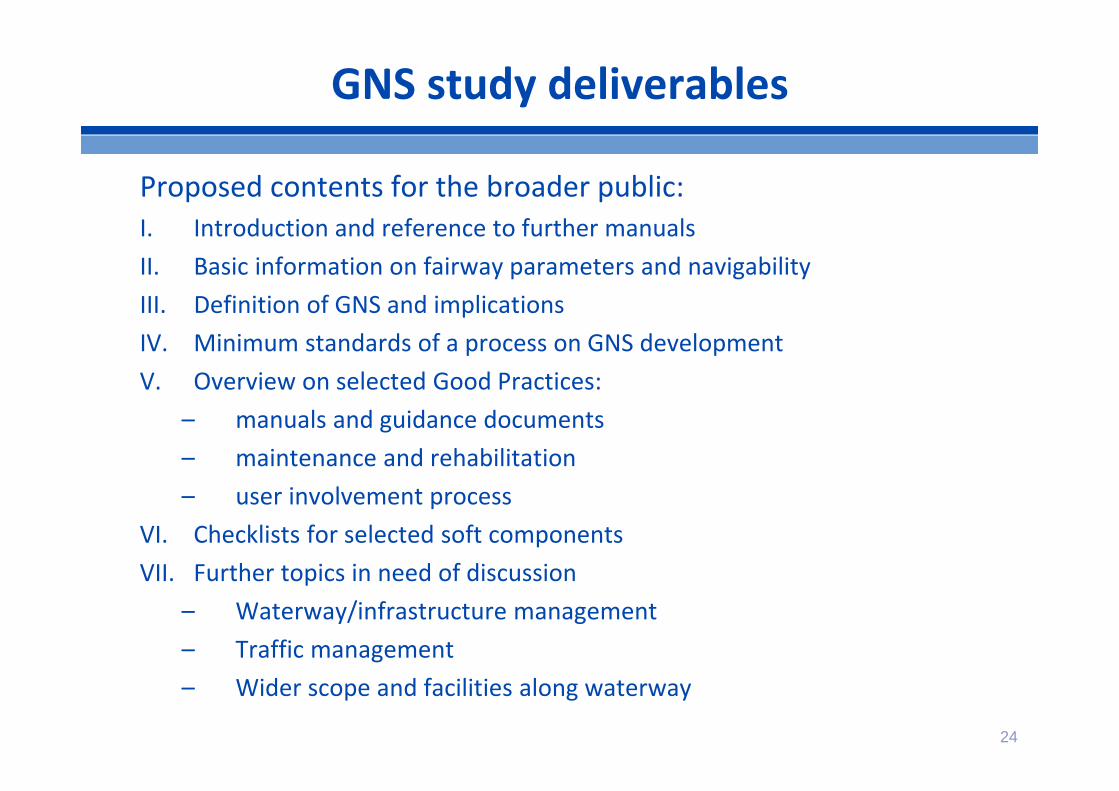
GNS study deliverables
Proposed contents for the broader public:I. Introduction and reference to further manualsII. Basic information on fairway parameters and navigabilityIII. Definition of GNS and implicationsIV. Minimum standards of a process on GNS developmentV. Overview on selected Good Practices:
– manuals and guidance documents– maintenance and rehabilitation– user involvement process
VI. Checklists for selected soft componentsVII. Further topics in need of discussion
– Waterway/infrastructure management– Traffic management– Wider scope and facilities along waterway

25
II. Fairway parameters and navigability
Key vocabulary and definitions Reference water levels Water levels and fairway depth Fairway depth and draught …
Sou
rce:
Xav
ax
26
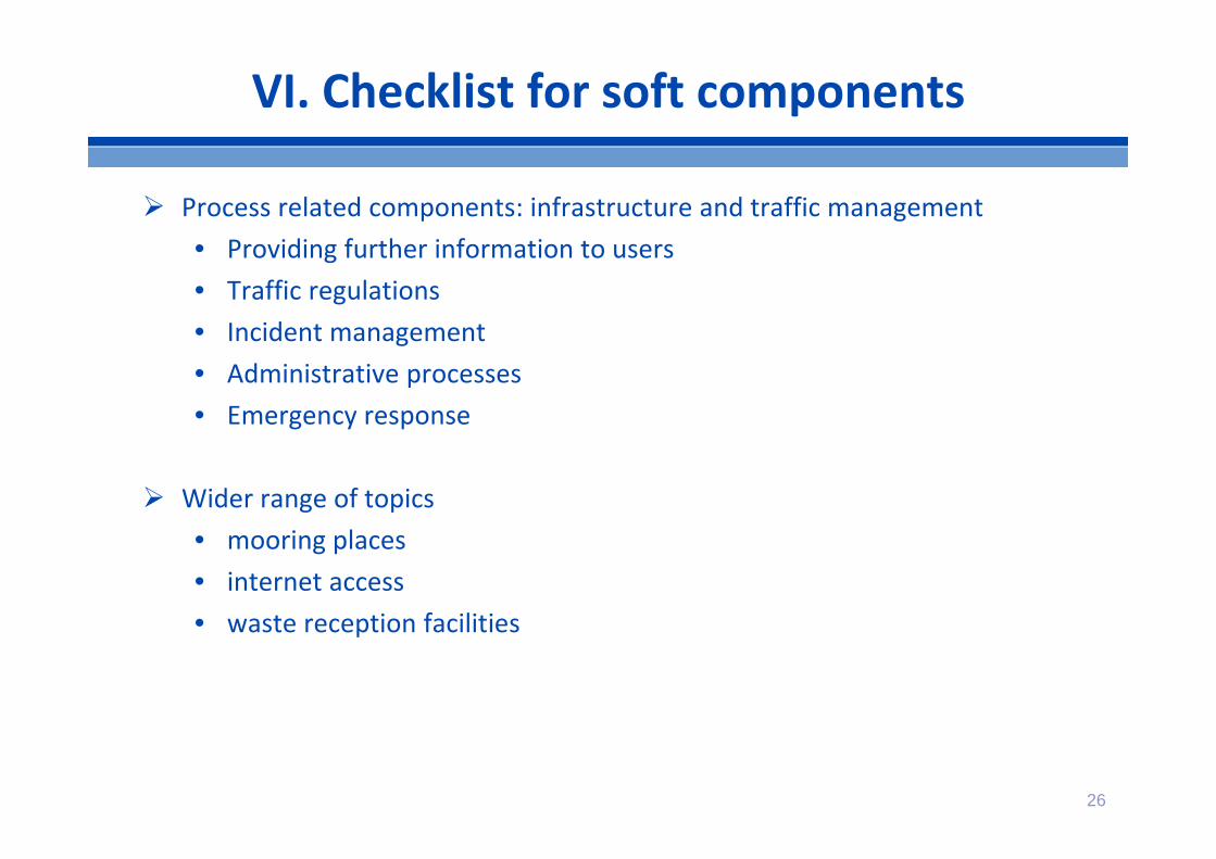
VI. Checklist for soft components
Process related components: infrastructure and traffic management• Providing further information to users• Traffic regulations• Incident management• Administrative processes• Emergency response
Wider range of topics• mooring places• internet access• waste reception facilities
Balance to be found between
• monitoring and reporting requirements
• administrative burden
• added value of GNS concept for the relevant area (tailor‐made)
Differentiation needed:
• Mature areas versus developing areas
• Canals vs (free flowing) rivers
• Specific needs (e.g. lakes, ice, heavy traffic, sensitive areas,…)
This study has rather limited resources. It can provide a first framework and address key issues but can not provide all answers and guidance from a top‐down EU perspective.
27
Some final remarks
Need for more elaboration and more tailor‐made / regionalised GNS approaches (e.g. free flowing rivers), broadening the guidelines and understanding about exemptions.
KPI on reliability of journeys in relation to locks/bridges: waiting times at locks or further elaboration taking into account new technologies
Development time is needed for further elaboration and understanding and tailor‐made approaches, in particular if infrastructural measures are needed to reach the Good Navigation Status in 2031.
28
Some final remarks

29
Discussion topics
How do you see the overall GNS concept and approach?
Relevant links between GNS, AGN and the Blue Book?
Added value of the GNS concept for non‐EU member States?
What could be a possible role of UNECE as regards the pan‐European roll‐out of GNS?
30
Thank you for your attention!
More information & contact details:
Martin Quispelquispel@stc‐nestra.nlPhone: +31 612952382