goes-r highlights bernie connell [email protected] cooperative institute for research in...
TRANSCRIPT

GOES-R highlights
Bernie [email protected]
Cooperative Institute for Research in the Atmosphere Colorado State University
December 2013
NASA image ISS006-E-48196

oWhy and When?o How are we evaluating them now?oWhat Sensors and Capabilities?oWhat major changes are expected?o Examples – RGB viewing of ice
cloud, water cloud, dust, ash, and airmass
o Information Links
Outline

• To replace the GOES N/O/P (13/14/15) series
• To maintain continuity of the GOES mission
• To provide significant increases in spatial, spectral, temporal, and radiometric resolution of products
Why GOES-R?

When?
http://www.nesdis.noaa.gov/FlyoutSchedules.html

How is the USA getting ready?Proving Ground + Training
research operations
• Infuse GOES-R like channels, products and techniques into NWS operations
• Encourage dialogue and feedback between developers and users.
http://cimss.ssec.wisc.edu/goes_r/proving-ground.html

GOES-R
• Which Sensors and Capabilities?– Communication Capabilities
• HRIT/EMWIN, DCS, SARSAT, GRB– Solar and Space Environment
• SUVI, EXIS, SEISS, MAG – Geostationary Lightning Mapper (GLM)– Advanced Baseline Imager (ABI)

Communication CapabilitiesImproved user services for direct readout:
GOES-R services include:• HRIT/EMWIN – High Rate Information
Transmission / Emergency Managers Weather Information Network • DCS--Data Collection System • GRB – GOES Rebroadcast
Follow on of L-Band GVAR• SARSAT--Search and Rescue Satellite
Aided Tracking

NOAA/NWS Space Weather Prediction Center
Earth-Space Activities disrupted by solar and
geomagnetic events•Satellite operations •Navigation•Space Station activities•High-altitude polar flights•Electric power distribution•Long-line telephone communication
•HF radio communications•Pipeline operations•Geophysical exploration
http://www.swpc.noaa.gov/ check out the Education/Outreach link
Why are we interested in Space Weather?

Geostationary Lightning Mapper (GLM)
An estimate of the annual climatological lightning density in the GLM viewing areas.

GLM•Detects total strikes: in cloud, cloud to cloud, and cloud to ground– Compliments today’s land based systems that only
measure cloud to ground lightning (about 15% of the total)
– Compliments today’s research based polar orbiting systems.
•Increased coverage over oceans and dead zones over land– Beneficial for aviation convective weather hazards

ABI: Advanced Baseline Imager
Increased resolution• temporal• spatial • spectral• radiometricBetter navigation

1/5 Disk
Increased Imaging Capability5 Minute Coverage
GOES-R
Full Disk
ABI Scan Modes• 15 minute cycle• 1 Full Disk• 3 CONUS• 1000km x 1000km every
30 seconds• Continuous 5 minute
Full Disk
Current GOES-I/P
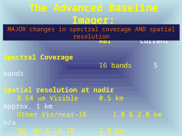
The Advanced Baseline Imager:
ABI Current
Spectral Coverage
16 bands 5 bands
Spatial resolution at nadir 0.64 mm Visible 0.5 km Approx. 1 kmOther Vis/near-IR 1.0 & 2.0 kmn/aSW, WV & LW IR 2.0 kmApprox. 4 km
(bands > 2µm)
MAJOR changes in spectral coverage AND spatial resolution

14 Cloud streets over the Black Sea (24 February 2007) by Mária Putsay, Kornél Kolláth and Ildikó Szenyán, Hungarian Meteorological Service
water
Cop
yrig
ht 2
007
EU
ME
TS
AT
METEOSATSecond Generation24 Feb. 200711:55 UTCRGB: NIR 1.6 VIS 0.8 VIS 0.6
MSG RGB 2007 Feb. 24: 11:55 UTC

METEOSAT-83 March 2004 12:00 UTC
EUMETSAT Satellite Image of the MonthDust storm over Western Africa and the Canary Islands Copyright 2004 EUMETSAT
RGB Composite IR12.0 – IR10.8IR10.8 – IR8.7IR10.8

RGB composite 12-10.8 10.8-8.7 10.8
Source: EUMETSAT Satellite Image of the Month
Eruption of the Chaitén volcano in Chile (2-9 May 2008) HansPeter Roesli andJochen Kerkmann
Copyright 2008 EUMETSAT

RGB Air Mass Product
Example courtesy of John Knaff, NOAA/NESDIS/STAR/RAMMB
RGB composite 6.2-7.3 9.7-12.2 6.2

Cor
resp
ondi
ng c
urre
nt Im
ager
ban
ds o
f Hur
rican
e K
atrin
a
3.9 m 6.5 m
10.7 m 13.3 m
0.65 m
NO
AA
/NE
SD
IS
STA
R a
nd
GO
ES
-R I
mag
ery
Team

0.64 m 0.86 m 1.38 m
1.61 m 2.26 m 3.9 m 6.19 m
6.95 m 7.34 m
0.47 m
8.5 m 9.61 m
10.35 m 11.2 m 12.3 m 13.3 m
AW
G P
roxy
AB
I Sim
ulat
ions
of H
urric
ane
Kat
rina
NO
AA
/NE
SD
IS
STA
R a
nd
GO
ES
-R I
mag
ery
Team

New instruments and capabilities:
Solar, Communication,
Geostationary Lightning Mapper (GLM),
and Advanced Baseline Imager (ABI)
Launch in late 2015
Operational 2017 or beyond
GOES-R Home Page http://www.goes-r.gov/
Summary

LinksGOES-R Home Pagehttp://www.goes-r.gov/
GOES-R Proving Groundhttp://cimss.ssec.wisc.edu/goes_r/proving-ground.html
SHyMet module: GOES-R 101http://rammb.cira.colostate.edu/training/shymet/forecaster_goesr101.asp
COMET module: Benefits of GOES-Rhttps://www.meted.ucar.edu/training_module.php?id=509
COMET module: GOES-R ABIhttps://www.meted.ucar.edu/training_module.php?id=987
COMET module: RGB Products Explainedhttps://www.meted.ucar.edu/training_module.php?id=568
EUMETSAT Image Galleryhttp://www.eumetsat.int/Home/Main/Image_Gallery/index.htm?l=en
Near Real Time MODIS images:http://lance-modis.eosdis.nasa.gov/cgi-bin/imagery/realtime.cgi