gold diamet resources ltd
TRANSCRIPT
CJP Exploration Inc. Larder Lake, Ontario
P0K1L0
GOLD DIAMET
RESOURCES LTD.
Magnetometer Survey
Over the
A1 PROPERTY Arnold Township, Ontario
Magnetometer SurveyA1 Property Arnold Township, Ontario
Gold Diamet Resources Limited
TABLE OF CONTENTS
1. SURVEY DETAILS .................................................................................................................................... 3
1.1 PROJECT NAME ............................................................................................................................. 3 1.2 CLIENT ......................................................................................................................................... 3 1.3 LOCATION ..................................................................................................................................... 3 1.4 ACCESS ........................................................................................................................................ 4 1.5 SURVEY AREA ............................................................................................................................... 4
2. SURVEY WORK UNDERTAKEN ................................................................................................................. 5
2.1 SURVEY LOG ................................................................................................................................. 5 2.2 PERSONNEL .................................................................................................................................. 5 2.3 SURVEY SPECIFICATIONS .............................................................................................................. 5
3. OVERVIEW OF SURVEY RESULTS .............................................................................................................. 6 3.1 SUMMARY ..................................................................................................................................... 6
LIST OF APPENDICES
APPENDIX A: STATEMENT OF QUALIFICATIONS APPENDIX B: INSTRUMENT SPECIFICATIONS APPENDIX C: LIST OF MAPS (IN MAP POCKET)
LIST OF TABLES AND FIGURES
Figure 1: Location of A1 Property ........................................................................................................... 3 Figure 2: Claim Map with Magnetic Traverses ....................................................................................... 4 Figure 3: Magnetic Survey on Google Earth .......................................................................................... 6 Figure 4: Magnetic Anomaly ................................................................................................................... 7 Table 1: Survey Log ............................................................................................................................... 5

Magnetometer SurveyA1 Property Arnold Township, Ontario
Gold Diamet Resources Limited
Page 3
1. SURVEY DETAILS
1.1 PROJECT NAME This project is known as the A1 Property.
1.2 CLIENT Gold Diamet Resources Ltd.
RR#1 #14778 Niagara Parkway Niagara on the Lake, Ontario L0S 1J0
1.3 LOCATION The A1 Property is located in Arnold Township approximately 16 km northeast of Kirkland Lake, On-tario. The traverse area covers portions of claims numbered 4252178, 4211816, 4252143 and 4240767 all located in Arnold Township, within the Larder Lake Mining Division.
Figure 1: Location of A1 Property
Magnetometer SurveyA1 Property Arnold Township, Ontario
Gold Diamet Resources Limited
Page 4
1.4 ACCESS Access to the property was attained with a 4x4 truck via highway 672 approximately 14km north of the junction of highways 672 and 66. At this point, the property borders the highway.
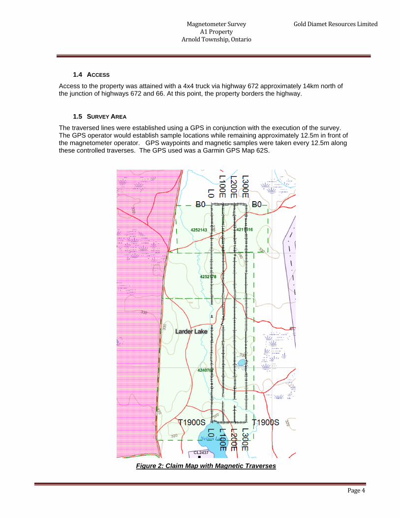
1.5 SURVEY AREA The traversed lines were established using a GPS in conjunction with the execution of the survey. The GPS operator would establish sample locations while remaining approximately 12.5m in front of the magnetometer operator. GPS waypoints and magnetic samples were taken every 12.5m along these controlled traverses. The GPS used was a Garmin GPS Map 62S.
Figure 2: Claim Map with Magnetic Traverses

Magnetometer SurveyA1 Property Arnold Township, Ontario
Gold Diamet Resources Limited
Page 5
2. SURVEY WORK UNDERTAKEN
2.1 SURVEY LOG Date Description Line Min Extent Max
Extent Total
Survey December 21, 2013 Locate survey area and perform sur-
vey. 0E 0 1900S 1900 300E 0 1900S 1900 0N 0 300E 300 1900S 0 300E 300
December 22, 2013 Complete survey. 100E 0 1900S 1900 200E 0 1900S 1900
Table 1: Survey Log
2.2 PERSONNEL Jason Ploeger of Larder Lake, Ontario conducted the magnetic data collection and Bruce Lavalley of Britt, Ontario was responsible for the GPS control and GPS waypoint collection.
2.3 SURVEY SPECIFICATIONS The survey was conducted with a GSM-19 v7 Overhauser magnetometer with a second GSM-19 magnetometer for a base station mode for diurnal correction.
A total of 8.2 line kilometers of no grid mag and VLF was performed between December 21st and 22nd, 2013. This consisted of 656 magnetometer samples taken at 12.5m intervals.

Magnetometer SurveyA1 Property Arnold Township, Ontario
Gold Diamet Resources Limited
Page 6
3. OVERVIEW OF SURVEY RESULTS
3.1 SUMMARY
Figure 3: Magnetic Survey on Google Earth

Magnetometer SurveyA1 Property Arnold Township, Ontario
Gold Diamet Resources Limited
Page 7
The magnetic survey was designed to target a magnetically elevated north south feature from the airborne mag map. This survey was able to identify the validity of this signature extending southward from the A1 kimberlite pipe.
Interestingly enough the orientation of the survey indicates a magnetically elevated region on the south side of the magnetic trend. This can be seen in figure 4. This anomalous area appears to be separated from the main trend is similar in size and magnitude to the anomaly of the A1 Kimberlite.
Figure 4: Magnetic Anomaly
I would recommend re-orienting the survey to east-west and performing a detailed magnetic survey over this area. The anomaly noted in this survey may represent another kimberlite pipe.

Magnetometer SurveyA1 Property Arnold Township, Ontario
Gold Diamet Resources Limited
APPENDIX A
STATEMENT OF QUALIFICATIONS
I, C. Jason Ploeger, hereby declare that:
1. I am a professional geophysicist with residence in Larder Lake, Ontario and am presently employed as a Geophysicist and President of CJP Exploration Inc. of Larder Lake, Ontario.
2. I am a Practicing Member of the Association of Professional Geoscientists, with membership number 2172.
3. I graduated with a Bachelor of Science degree in geophysics from the University of Western Ontario, in
London Ontario, in 1999. 4. I have practiced my profession continuously since graduation in Africa, Bulgaria, Canada, Mexico and
Mongolia.
5. I am a member of the Ontario Prospectors Association, a Director of the Northern Prospectors Associa-tion and a member of the Society of Exploration Geophysicists.
6. I do not have nor expect an interest in the properties and securities of Gold Diamet Resources Ltd.
7. I am responsible for the final processing and validation of the survey results and the compilation of the
presentation of this report. The statements made in this report represent my professional opinion based on my consideration of the information available to me at the time of writing this report.
C. Jason Ploeger, P.Geo., B.Sc.
President CJP Exploration Inc.
Larder Lake, ON January 13, 2013
Magnetometer SurveyA1 Property Arnold Township, Ontario
Gold Diamet Resources Limited
APPENDIX B
THEORETICAL BASIS AND SURVEY PROCEDURES
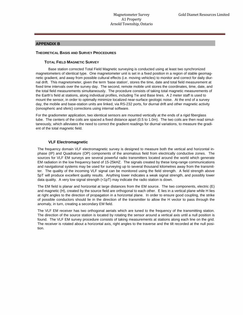
TOTAL FIELD MAGNETIC SURVEY Base station corrected Total Field Magnetic surveying is conducted using at least two synchronized
magnetometers of identical type. One magnetometer unit is set in a fixed position in a region of stable geomag-netic gradient, and away from possible cultural effects (i.e. moving vehicles) to monitor and correct for daily diur-nal drift. This magnetometer, given the term ‘base station’, stores the time, date and total field measurement at fixed time intervals over the survey day. The second, remote mobile unit stores the coordinates, time, date, and the total field measurements simultaneously. The procedure consists of taking total magnetic measurements of the Earth’s field at stations, along individual profiles, including Tie and Base lines. A 2 meter staff is used to mount the sensor, in order to optimally minimize localized near-surface geologic noise. At the end of a survey day, the mobile and base-station units are linked, via RS-232 ports, for diurnal drift and other magnetic activity (ionospheric and sferic) corrections using internal software.
For the gradiometer application, two identical sensors are mounted vertically at the ends of a rigid fiberglass tube. The centers of the coils are spaced a fixed distance apart (0.5 to 1.0m). The two coils are then read simul-taneously, which alleviates the need to correct the gradient readings for diurnal variations, to measure the gradi-ent of the total magnetic field.
VLF Electromagnetic The frequency domain VLF electromagnetic survey is designed to measure both the vertical and horizontal in-phase (IP) and Quadrature (OP) components of the anomalous field from electrically conductive zones. The sources for VLF EM surveys are several powerful radio transmitters located around the world which generate EM radiation in the low frequency band of 15-25kHZ. The signals created by these long-range communications and navigational systems may be used for surveying up to several thousand kilometres away from the transmit-ter. The quality of the incoming VLF signal can be monitored using the field strength. A field strength above 5pT will produce excellent quality results. Anything lower indicates a weak signal strength, and possibly lower data quality. A very low signal strength (<1pT) may indicate the radio station is down.
The EM field is planar and horizontal at large distances from the EM source. The two components, electric (E) and magnetic (H), created by the source field are orthogonal to each other. E lies in a vertical plane while H lies at right angles to the direction of propagation in a horizontal plane. In order to ensure good coupling, the strike of possible conductors should lie in the direction of the transmitter to allow the H vector to pass through the anomaly, in turn, creating a secondary EM field.
The VLF EM receiver has two orthogonal aerials which are tuned to the frequency of the transmitting station. The direction of the source station is located by rotating the sensor around a vertical axis until a null position is found. The VLF EM survey procedure consists of taking measurements at stations along each line on the grid. The receiver is rotated about a horizontal axis, right angles to the traverse and the tilt recorded at the null posi-tion.
Magnetometer SurveyA1 Property Arnold Township, Ontario
Gold Diamet Resources Limited
APPENDIX C
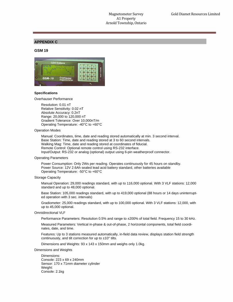
GSM 19
Specifications Overhauser Performance
Resolution: 0.01 nT Relative Sensitivity: 0.02 nT Absolute Accuracy: 0.2nT Range: 20,000 to 120,000 nT Gradient Tolerance: Over 10,000nT/m Operating Temperature: -40°C to +60°C
Operation Modes
Manual: Coordinates, time, date and reading stored automatically at min. 3 second interval. Base Station: Time, date and reading stored at 3 to 60 second intervals. Walking Mag: Time, date and reading stored at coordinates of fiducial. Remote Control: Optional remote control using RS-232 interface. Input/Output: RS-232 or analog (optional) output using 6-pin weatherproof connector.
Operating Parameters
Power Consumption: Only 2Ws per reading. Operates continuously for 45 hours on standby. Power Source: 12V 2.6Ah sealed lead acid battery standard, other batteries available Operating Temperature: -50°C to +60°C
Storage Capacity
Manual Operation: 29,000 readings standard, with up to 116,000 optional. With 3 VLF stations: 12,000 standard and up to 48,000 optional.
Base Station: 105,000 readings standard, with up to 419,000 optional (88 hours or 14 days uninterrupt-ed operation with 3 sec. intervals)
Gradiometer: 25,000 readings standard, with up to 100,000 optional. With 3 VLF stations: 12,000, with up to 45,000 optional.
Omnidirectional VLF
Performance Parameters: Resolution 0.5% and range to ±200% of total field. Frequency 15 to 30 kHz.
Measured Parameters: Vertical in-phase & out-of-phase, 2 horizontal components, total field coordi-nates, date, and time.
Features: Up to 3 stations measured automatically, in-field data review, displays station field strength continuously, and tilt correction for up to ±10° tilts.
Dimensions and Weights: 93 x 143 x 150mm and weighs only 1.0kg.
Dimensions and Weights
Dimensions: Console: 223 x 69 x 240mm Sensor: 170 x 71mm diameter cylinder Weight: Console: 2.1kg

Magnetometer SurveyA1 Property Arnold Township, Ontario
Gold Diamet Resources Limited
Sensor and Staff Assembly: 2.0kg
Standard Components
GSM-19 magnetometer console, harness, battery charger, shipping case, sensor with cable, staff, instruction manual, data transfer cable and software.
Taking Advantage of a “Quirk” of Physics
Overhauser effect magnetometers are essentially proton precession devices except that they produce an order-of magnitude greater sensitivity. These "supercharged" quantum magnetometers also deliver high absolute accu-racy, rapid cycling (up to 5 readings / second), and exceptionally low power consumption.
The Overhauser effect occurs when a special liquid (with unpaired electrons) is combined with hydrogen atoms and then exposed to secondary polarization from a radio frequency (RF) magnetic field. The unpaired electrons transfer their stronger polarization to hydrogen atoms, thereby generating a strong precession signal-- that is ideal for very high-sensitivity total field measurement. In comparison with proton precession methods, RF signal generation also keeps power consumption to an absolute minimum and reduces noise (i.e. generating RF fre-quencies are well out of the bandwidth of the precession signal).
In addition, polarization and signal measurement can occur simultaneously - which enables faster, sequential measurements. This, in turn, facilitates advanced statistical averaging over the sampling period and/or increased cycling rates (i.e. sampling speeds).
The unique Overhauser unit blends physics, data quality, operational efficiency, system design and options into an instrumentation package that ... exceeds proton precession and matches costlier optically pumped cesium capabilities.

Magnetometer SurveyA1 Property Arnold Township, Ontario
Gold Diamet Resources Limited
APPENDIX C
GARMIN GPS MAP 62S
Physical & Performance: Unit dimensions, WxHxD: 2.4" x 6.3" x 1.4" (6.1 x 16.0 x 3.6 cm)
Display size, WxH: 1.43" x 2.15" (3.6 x 5.5 cm); 2.6" diag (6.6 cm)
Display resolution, WxH: 160 x 240 pixels
Display type: transflective, 65-K color TFT
Weight: 9.2 oz (260.1 g) with batteries
Battery: 2 AA batteries (not included); NiMH or Lithium recommended
Battery life: 20 hours
Waterproof: yes (IPX7)
Floats: no
High-sensitivity receiver: yes
Interface: high-speed USB and NMEA 0183 compatible
Maps & Memory: Basemap: yes
Preloaded maps: no
Ability to add maps: yes
Built-in memory: 1.7 GB

Magnetometer SurveyA1 Property Arnold Township, Ontario
Gold Diamet Resources Limited
Accepts data cards: microSD™ card (not included)
Waypoints/favorites/locations: 2000
Routes: 200
Track log: 10,000 points, 200 saved tracks
Features & Benefits: Automatic routing (turn by turn routing on roads): yes (with optional mapping for detailed roads)
Electronic compass: yes (tilt-compensated, 3-axis)
Touchscreen: no
Barometric altimeter: yes
Camera: no
Geocaching-friendly: yes (paperless)
Custom maps compatible: yes
Photo navigation (navigate to geotagged photos): yes
Outdoor GPS games: no
Hunt/fish calendar: yes
Sun and moon information: yes
Tide tables: yes
Area calculation: yes
Custom POIs (ability to add additional points of interest): yes
Unit-to-unit transfer (shares data wirelessly with similar
units): yes
Picture viewer: yes
Garmin Connect™ compatible (online community where
you analyze, categorize and share data): yes
Specifications obtained from www.garmin.com

Magnetometer SurveyA1 Property Arnold Township, Ontario
Gold Diamet Resources Limited
APPENDIX C
LIST OF MAPS (IN MAP POCKET)
Posted contoured TFM plan map (1:2500) 1) GOLD DIAMET-A1-MAG-CONT
Claim Map with Survey Traverses
2) GOLD DIAMET-A1-GRID
TOTAL MAPS=2