golden eagle conservation plan for the … eagle conservation plan for the ocotillo wind energy...
TRANSCRIPT

GOLDEN EAGLE CONSERVATION PLAN FOR THE OCOTILLO WIND ENERGY FACILITY
DRAFT CONFIDENTAL
Ocotillo Express LLC 1600 Smith Street, Suite 4025
Houston, Texas 77002
March 3, 2011

Ocotillo Wind Golden Eagle Conservation Plan
March 2011 i
CONTENTS 1.0 INTRODUCTION ................................................................................................................................ 1
1.1 Project Background .......................................................................................................................... 11.2 Environmental Setting ..................................................................................................................... 21.3 Migratory Bird Treaty Act and Bald and Golden Eagle Protection Act .......................................... 31.4 Pattern Energy Policy and Commitment to Environmental Protection ........................................... 4
2.0 SITE SPECIFIC SURVEYS AND ASSESSMENTS (STAGE 2) .................................................... 42.1 Golden Eagle Nest Surveys ............................................................................................................. 4
2.1.1 Methods .............................................................................................................................. 42.1.2 Results ................................................................................................................................. 52.1.3 Discussion ........................................................................................................................... 5
2.2 Avian Point Counts .......................................................................................................................... 62.2.1 Methods .............................................................................................................................. 62.2.2 Golden Eagle Results .......................................................................................................... 72.2.3 Discussion ........................................................................................................................... 8
2.3 Golden Eagle Migration Surveys ..................................................................................................... 82.3.1 Methods .............................................................................................................................. 82.3.2 Results ................................................................................................................................. 82.3.3 Discussion ........................................................................................................................... 9
2.4 Golden Eagle Use ............................................................................................................................ 9
3.0 ASSESSING GOLDEN EAGLE RISK AND PREDICTING FATALITIES (STAGE 3) ........... 113.1 Assessing Golden Eagle Risk at OWEF ........................................................................................ 11
3.1.1 Nesting and Breeding ........................................................................................................ 113.1.2 Concentration Areas (Communal roosts, foraging areas, migration corridors, and
migration stopovers) ......................................................................................................... 133.1.3 Eagle Risk Factors ............................................................................................................ 13
3.2 Fatality Predictions ........................................................................................................................ 193.3 Categorizing Site according to Risk ............................................................................................... 23
4.0 AVOIDANCE AND MINIMIZATION OF RISK USING ADVANCED CONSERVATION PRACTICE’S AND COMPENSATORY MITIGATION (STAGE 4) ............... 23
4.1 ACP’s Pre-Construction ................................................................................................................. 234.2 ACP’s during Construction ............................................................................................................ 234.3 ACP’s during Operation ................................................................................................................ 244.4 Additional ACP’s ........................................................................................................................... 254.5 Re-evaluation of Risk Considering ACP’s .................................................................................... 254.6 Compensatory Mitigation .............................................................................................................. 264.7 Cumulative Impacts ....................................................................................................................... 26
4.7.1 Population Status .............................................................................................................. 26
5.0 POST-CONSTRUCTION MONITORING (STAGE 5) ................................................................. 265.1 Radar and Biological Monitoring .................................................................................................. 275.2 Fatality Monitoring ........................................................................................................................ 305.3 Golden Eagle Nest Surveys ........................................................................................................... 305.4 Reporting ....................................................................................................................................... 30

Ocotillo Wind Golden Eagle Conservation Plan
March 2011 ii
6.0 ADAPTIVE MANAGEMENT .......................................................................................................... 306.1 Adaptive Management Process ...................................................................................................... 316.2 Agency Interaction ......................................................................................................................... 31
7.0 PUBLIC OUTREACH ....................................................................................................................... 31
8.0 CONCLUSION ................................................................................................................................... 31
9.0 LITERATURE CITED ...................................................................................................................... 31

Ocotillo Wind Golden Eagle Conservation Plan
March 2011 1
1.0 INTRODUCTION
1.1 Project Background Pattern Energy, through Ocotillo Express LLC (OE LLC), is proposing a wind energy facility known as the Ocotillo Express Wind Energy Facility (OWEF) near Ocotillo, California, in Imperial County (Figure 1). The OWEF will be located primarily on Bureau of Land Management (BLM) land and a small portion of private land. The OWEF will be located on approximately 15,000 acres in the project area and consist of up to 158 turbines (up to 474 megawatts [MW]) and associated infrastructure. The diameter of the circle swept by the blades will be no more than 371 feet (113 meters). The OWEF will connect to the new SDG&E Sunrise Powerlink 500-kilovolt (kV) transmission line scheduled for completion in June 2012 across the middle of the project site. The collection lines connecting one turbine to the next and to the project substation will be buried underground generally adjacent to the interior turbine access roads. The OWEF Plan of Development (POD) was tentatively finalized in February 2011 but may change in response to comments on the preliminary Environmental Impact Report/Environmental Impact Assessment (EIR/EIS).
Figure 1. General location of the Ocotillo Wind Energy Facility.

Ocotillo Wind Golden Eagle Conservation Plan
March 2011 2
1.2 Environmental Setting The project site is located within four U.S. Geological Survey 7.5-minute quadrangle maps; Carrizo Mountain, Coyote Wells, In-Ko-Pah Gorge, and Painted Gorge. The northern portion of the site is generally situated north of Interstate 8 (I-8), from the Imperial/San Diego County border on its western edge to approximately 1.5 miles northeast of the town of Ocotillo on its eastern edge. The northern area includes several distinct features, including a portion of the I-8 Island, which is undeveloped rocky and hilly terrain between the eastbound and westbound lanes of I-8, Sugarloaf Mountain, and a portion of the San Diego and Arizona Eastern railroad tracks. County Route (CR) S2 bisects the northern project area, and I-8 passes through the southern portion of the northern project area. The southern area is much smaller than the northern area and the majority is south of State Route (SR) 98. Vegetation on site consists of a variety of desert scrub habitat types (National Land Cover Database [NLCD] 2001; Figure 2). Several dry desert washes cut through the site, generally from west to east: Palm Canyon Wash cuts through the center of the northern project area; Myer Creek Wash cuts through the southern portion of the northern project area; a portion of Coyote Wash cuts through the northwest portion of the southern project area; and several additional unnamed washes cut through the site.
Figure 2. Landuse/Landcover information for the Ocotillo Wind Energy Facility (NLCD 2001).
Elevations on site range from approximately 300 feet above mean sea level (AMSL) in the northeast portion of the site to approximately 1,700 feet AMSL in the southwest portion of the site (Figure 3). The

Ocotillo Wind Golden Eagle Conservation Plan
March 2011 3
site generally slopes downward from the west to the east, with the Coyote Mountains to the north of the site, and the Jacumba Mountains to the west and south of the site.
Figure 3. Digital elevation map of the Ocotillo Wind Energy Facility.
1.3 Migratory Bird Treaty Act and Bald and Golden Eagle Protection Act The federal regulatory framework for protecting eagles includes the Migratory Bird Treaty Act (MBTA) of 1918 and the Bald and Golden Eagle Protection Act (BGEPA) of 1940. The MBTA prohibits the take of migratory birds and does not include provisions for allowing unauthorized take. This project affords substantial design measures to avoid and minimize the likelihood of take, but if take occurs, it will be reported to the U.S. Fish and Wildlife Service (USFWS) for further action. Additionally, this Eagle Conservation Plan (ECP) has been developed to meet BLM and USFWS requirements for addressing BGEPA and the MBTA as it relates to eagles. Both the BGEPA and the MBTA prohibit take as defined as pursue, shoot, shoot at, poison, wound, kill, capture, trap, collect, destroy, molest, disturb, or otherwise harm eagles, their nests, or their eggs. Under the BGEPA, “disturb” means to agitate or bother a bald or golden eagle to a degree that causes, or is likely to cause, based on the best scientific information available: 1) injury to an eagle; 2) decrease in its productivity, by substantially interfering with normal breeding, feeding, or sheltering behavior; or 3) nest abandonment, by substantially interfering with normal breeding, feeding, or sheltering behavior. However, on September 11, 2009 (Federal Register, 50

Ocotillo Wind Golden Eagle Conservation Plan
March 2011 4
Code of Federal Regulations [CFR] 13 and 22), the USFWS set in place rules establishing two new permit types: 1) take of bald and golden eagles that is associated with, but not the purpose of, the activity; and 2) purposeful take of eagle nests that pose a threat to human or eagle safety. As described in the USFWS Draft Eagle Conservation Plan (ECP) Guidance dated January 2011, the USFWS recommends that project proponents prepare an ECP to avoid, minimize, and mitigate project-related impacts to eagles to ensure no-net-loss to the golden eagle population. Pursuant to BLM Instructional Memorandum (IM) 2010-156, the BLM will request “concurrence” from the USFWS that the ECP meets specific requirements.
1.4 Pattern Energy Policy and Commitment to Environmental Protection Pattern Energy is an independent, fully integrated energy company that develops, constructs, owns, and operates wind power projects across North America and parts of Latin America. Pattern Energy commenced operations in June 2009 as one of the most experienced and best capitalized renewable energy companies in the United States. OE LLC, through Pattern, is dedicated to delivering the highest values for their partners and the communities where they work, while exhibiting a strong commitment to promoting environmental stewardship and corporate responsibility. The OE LLC team has a proven track record of using science and ground-breaking technology to build wind projects that successfully coexist with wildlife and protect the environment. OE LLC is committed to building environmentally responsible renewable energy projects and continues to work closely with environmental agencies to develop appropriate mitigation measures to reduce impacts to wildlife.
2.0 SITE SPECIFIC SURVEYS AND ASSESSMENTS (STAGE 2) One and a half years of baseline data has been collected on golden eagles in the vicinity of the OWEF beginning in the fall of 2009, and two years will be completed after the spring 2011 surveys. Golden eagle nest surveys, raptor migration surveys, and avian point counts have been conducted (Helix 2010a, 2010b, 2011). Golden eagle nest surveys were conducted by Wildlife Research Institute (WRI), a local firm that has extensive historical information on golden eagles nesting in the vicinity of the OWEF. Migration surveys were conducted by Helix Environmental Planning, Inc (HELIX) in the fall of 2009 and spring and fall of 2010. Avian use point counts were conducted throughout the various seasons from September 2009 to August 2010. The following sections provide more details on the site-specific baseline golden eagle information collected for the OWEF.
2.1 Golden Eagle Nest Surveys
2.1.1 Methods HELIX contracted with the WRI to conduct surveys of golden eagle (Aquila chrysaetos) nest sites in eagle territories that occur within 10 miles of the project site, in accordance with the guidance provided in the U.S. Fish and Wildlife Service (USFWS) Inventory and Monitoring Protocols (Pagel et al. 2010). WRI conducted helicopter surveys in four known territories (referred to as Coyote Mountains West, Coyote Mountains East, Table Mountain, and Carrizo Gorge) in the spring 2010. A hand-held GPS was used to record the helicopter flight path and the location of each nest site. Nest-specific information was documented by two eagle biologists in the helicopter, and each nest site was photographed. In addition to helicopter surveys, WRI conducted ground surveys of an additional suspected golden eagle territory (referred to as Mountain Springs) in the spring 2010. Helicopter surveys were not allowed by USFWS in the Mountain Springs area because of potential disturbance to Peninsular bighorn sheep (Ovis canadensis nelsoni).


Ocotillo Wind Golden Eagle Conservation Plan
March 2011 6
the proposed OWEF. The long-term data help in understanding use of the territories in relation to the OWEF. Based on the golden eagle nest data from 2010, none of the nests identified in 2010 were within two miles of proposed turbine locations. The one active nest in the Coyote Mountains West territory was located 3.6 miles from proposed turbine locations. No other active nests were confirmed during the 2010 raptor nest surveys conducted within 10 miles of the OWEF.
2.2 Avian Point Counts
2.2.1 Methods HELIX conducted Avian Point Counts (APC’s) approximately weekly over a one-year period (September 1, 2009 – August 31, 2010). The APC’s were conducted in accordance with the survey protocols approved by BLM (HELIX 2010a) and generally in accordance with the bird use count methods described in the California Guidelines for Reducing Impacts to Birds and Bats from Wind Energy Development (California Energy Commission [CEC] 2007). The goal of the APC’s was to record bird species, abundance, behavior, and flight characteristics from selected sampling locations over a 30-minute period. A total of 50 weeks of point counts were conducted over the one-year period (APC’s were not conducted the week of November 29-December 5, 2009, or the week of January 17-23, 2010). Each APC location was visited once per week (the one exception is that Location 13 was not surveyed the week of February 21-27, 2010). Twenty-one APC locations were established approximately one mile apart throughout the approximately 15,000 acre site (Figure 5). The CEC Guidelines allow for locations to be 5,200 feet apart for large wind resource areas with good viewsheds, which is the case for the proposed Ocotillo site. The APC locations were chosen based on viewsheds, elevation, and habitat types. Each location had good visibility in all directions, with no major impediments impairing the range of view. Locations also covered a wide range of elevations, from approximately 340 ft AMSL (Location 4) to approximately 1,250 ft AMSL (Location 18). Finally, APC’s were strategically located to sample different microhabitats. Although each of the locations occurred in desert scrub habitat, several of the locations were within and adjacent to dry desert washes (e.g., Locations 6, 10, 13, 14, and 21) while others were located on or adjacent to hilly topography (e.g., Locations 2, 12, 18, and 19).

Ocotillo Wind Golden Eagle Conservation Plan
March 2011 7
Figure 5. Avian and raptor migration point stations at the Ocotillo Wind Energy Facility. At each APC location the species, number of individuals, flight height, flight direction, distance from observer, and behavior (e.g., directional flight, perched, flapping flight, soaring, etc.) was recorded over a 30-minute period. Weather conditions (e.g., temperature, wind speed and direction, and cloud cover) were recorded at the start and end of the 30-minute survey period using a hand-held Kestrel anemometer. Species were detected visually with the aid of binoculars and by identifying songs and call notes. All observations were recorded on standardized data sheets. APC’s were conducted once per week at each location. Efforts were made to sequence observation times so that locations were surveyed both in the morning and in the afternoon and under varying weather conditions, in accordance with the CEC’s Guidelines (CEC 2007).
2.2.2 Golden Eagle Results Three golden eagles (two adults and one juvenile) were observed flying north over the western portion of the project area during Week One at approximately 1000 feet above ground level (outside the Rotor Swept Area [RSA]; Table 1). No other golden eagles were observed during weekly point counts, but were observed during fall 2009 migration counts (see below; HELIX 2010). Table 1. Summary of golden eagle observations during avian point counts at the Ocotillo Wind
Farm, September 1, 2009 – August 31, 2010.
Date Time of
Observation # of
Individuals Age Flight Height
(ft above ground) Distance From Observer (ft)
2-Sep-09 1110 to 1112 3 2 Adults; 1 Juvenile 1,000 600

Ocotillo Wind Golden Eagle Conservation Plan
March 2011 8
2.2.3 Discussion The Ocotillo Wind Energy site does not support large populations of resident golden eagles. The site does not appear to be part of a major migration corridor for golden eagles. Golden eagles were seen only once during the point counts study (September 2, 2009) and were observed flying at a height above the RSA.
2.3 Golden Eagle Migration Surveys
2.3.1 Methods HELIX conducted migration counts over an eight calendar-week period during the 2009 fall migration period (September 24-November 10, 2009), over a 10 calendar-week period during the 2010 spring migration period (March 22-May 28, 2010), and over a 12 calendar-week period during the 2010 fall migration period (August 23-November 12, 2010). The methods of each survey were developed in coordination with the BLM and were based on the recommendations provided in the California Guidelines for Reducing Impacts to Birds and Bats from Wind Energy Development (CEC 2007). The purpose of the migration study was to document the diurnal raptor activity within the proposed project area in order to provide a risk assessment for these species. HELIX stationed four surveyors throughout the site to scan the sky and record bird migration data. The four migration count locations (Locations A through D; Figure 5) were spaced approximately two miles apart, generally along a southwest-northeast axis across the site. Migration count points were located to maximize the likelihood of detecting potential north-south and east-west migration through the site.
2.3.2 Results A total of 763 observation hours were logged during the fall of 2009. Nine golden eagle observations were recorded during the fall of 2009 (Table 2). A total of 952 observation hours were logged during the spring of 2010. No golden eagles were observed during spring migration counts; however, a single golden eagle was observed during a burrowing owl survey on the site on June 17, 2010 (Table 3). A total of 577.5 observation hours were logged in the fall of 2010, and 11 golden eagles were observed during the fall migration counts in 2010 (Table 4). Table 2. Summary of golden eagle observations during Fall 2009 raptor migration surveys at the
Ocotillo Wind Farm, September 24 – November 10, 2009.
Date Time of
Observation # of
Individuals Age Flight Height
(ft above ground) Distance From Observer (ft)
25-Sep-09 1440 to 1442 1 Juvenile 400 300 25-Sep-09 1545 to 1555 1 Juvenile 400 – 4,000 5,000 2-Oct-09 1315 to 1319 2 n/a 800 – 1,200 * 1,000
22-Oct-09 1145 to 1212 2 Undetermined 200 – 500 7,000 30-Oct-09 1325 to 1335 1 Juvenile 200 – 1,000 3,000 10-Nov-09 1230 to 1330 2 1 Adult; 1 Juvenile 0 – 300 1,000 – 10,000
*Individuals observed on October 2 were recorded during additional migration observation hours.

Ocotillo Wind Golden Eagle Conservation Plan
March 2011 9
Table 3. Summary of incidental golden eagle observations during Spring 2010 raptor migration surveys at the Ocotillo Wind Farm, March 22 – May 28, 2010. No golden eagles were observed during Spring 2010 raptor migration surveys.
Date Time of
Observation # of
Individuals Age Flight Height
(ft above ground) Distance from Observer (ft)
17-Jun-10 0530 to 0532 1 Adult † 0 – 100 20 17-Jun-10 0630 to 0631 1 Adult † 0 – 20 200 †
Determined to be the same individual observed separately by two biologists during burrowing owl surveys (Helix 2010b).
Table 4. Summary of golden eagle observations* during Fall 2010 raptor migration surveys at
the Ocotillo Wind Farm, August 23 – November 12, 2010.
Date # of Individuals Age Flight Height
(ft above ground) Distance from Observer (ft)
21-Sep-10 1 Undetermined 500 9,000 4-Oct-10 1 Juvenile 400 – 500 6,000 13-Oct-10 1 Adult 35 – 3,000 30 – 3,500 29-Oct-10 1 Adult 100 – 800 3,000 – 7,000 3-Nov-10 1 Undetermined 1,500 – 2,000 3,000 – 9,000 5-Nov-10 1 Undetermined 200 – 400 3,000 – 9,000 5-Nov-10 1 Undetermined 100 – 600 200 – 1,000
10-Nov-10 1 Undetermined 400 – 1,250 400 – 8,000 12-Nov-10 1 Adult 150 – 500 2,000 – 3,000 12-Nov-10 2 1 Adult; 1 Juvenile 150 – 1,000 4,000 – 20,000
*time of observation was not available.
2.3.3 Discussion The Ocotillo Wind Energy Project site is not located in a known raptor migration corridor (Aspen Environmental Group 2008; pers. comm., Unitt 2007). The majority of the project site supports desert scrub vegetation and dry desert washes. The site does not contain the appropriate topography to funnel migrating birds through the site. With the exception of Sugarloaf Mountain and the rocky terrain in the southwest portion of the site, the project is generally flat and is located east of the Jacumba Mountains and south of the Coyote Mountains. The southwesterly prevailing wind direction would not appear to be conducive to creating updrafts in the project site that are often associated with high raptor migration areas. The site lacks a major ridgeline, water bodies, and large stands of mature trees. The closest major water body is the Salton Sea, which is 30 miles to the northeast of the site, and the irrigated agriculture fields near El Centro are approximately 15 miles to the west of Ocotillo. The results of HELIX’s labor-intensive fall 2009 and spring and fall 2010 migration counts indicate that the Ocotillo Wind Energy Project site is not part of a major migratory pathway for golden eagles.
2.4 Golden Eagle Use A total of 2,817 observation hours were logged and only twenty-two golden eagle observations were recorded resulting in less than 0.01 golden eagle observations per hour (Table 5). These golden eagle use estimates suggest relatively low use of the project site during the study year, especially when compared to other projects in California, such as the High Winds Wind Resource Area (0.3 eagles/30-min survey

Ocotillo Wind Golden Eagle Conservation Plan
March 2011 10
during pre-construction surveys; Kerlinger et al. 2005, 2006),the Diablo Winds Wind Resource Area (0.3 eagles/30-min survey during the post-construction period; WEST 2008). Table 5. Summary of golden eagle observations, raptor observations*, sampling effort, and mean
use at the Ocotillo Wind Farm during raptor migration surveys and avian point counts, September 1, 2009 – November 10, 2010.
Season Species Group Observations Sampling Effort
(hours) Mean Use
(Obs/Hour) Raptor Migration Surveys
Fall 2009** golden eagles 8 763 0.01
raptors and vultures 165 763 0.22 Raptors 141 763 0.18
Spring 2010 golden eagles 0 952 0
raptors and vultures 520 952 0.55 Raptors 204 952 0.21
Fall 2010 golden eagles 11 577.5 0.02
raptors and vultures 423 577.5 0.73 Raptors 340 577.5 0.59
Year One (Fall 2009,
Spring 2010)
golden eagles 8 1,715 < 0.01 raptors and vultures 685 1,715 0.40
Raptors 345 1,715 0.20
All Seasons golden eagles 19 2,292.5 0.01
raptors and vultures 1,108 2,292.5 0.48 Raptors 685 2,292.5 0.30
Avian Point Counts 1-Sep-09 through
31-Aug-10
golden eagles 3 524.5 0.01 raptors and vultures 225 524.5 0.43
Raptors 143 524.5 0.27 Concurrent Surveys
1-Sep-09
†
through 31-Aug-10
golden eagles 11 2,239.5 < 0.01 raptors and vultures 910 2,239.5 0.41
Raptors 488 2,239.5 0.22 All Surveys To Date
1-Sep-09 through
12-Nov-10
golden eagles 22 2,817 0.01 raptors and vultures 1,333 2,817 0.47
Raptors 828 2,817 0.29 *Raptor data reported by HELIX Environmental Planning, Inc. included turkey vultures (Helix 2010a, 2010b, 2011,
unpublished data). **Large numbers of raptors and turkey vultures were not documented during Fall 2009 raptor migration surveys
(Helix 2010) †
Includes Fall 2009 and Spring 2010 raptor migration data and all avian point count data.

Ocotillo Wind Golden Eagle Conservation Plan
March 2011 11
3.0 ASSESSING GOLDEN EAGLE RISK AND PREDICTING FATALITIES (STAGE 3)
3.1 Assessing Golden Eagle Risk at OWEF
3.1.1 Nesting and Breeding The 2010 golden eagle nest surveys indicated that two of the five territories (Coyote Mountains West and Table Mountain) were active in 2010, while the remaining three territories were considered to be inactive. However, no active nests were identified. Appendix A shows the history of each of the four territories that have been monitored. It is clear these territories generally have not been consistently active, occupied, or productive for the last decade. Turbines have been sited greater than two miles from all of the 21 historic golden eagle nests identified within a 10-mile buffer of the project (Table 6). Eleven of the historic nests have at least one turbine within a five-mile buffer. The maximum number of turbines within a five-mile buffer of an eagle nest is 90. The maximum number of turbines that are located within 10 miles of an eagle nest is 141 (Table 6). The approach in the Draft Eagle Conservation Plan Guidance calls for measuring nearest neighbor distances from active nests (USFWS 2011). Since only one nest was considered active, this is not possible. Instead, the average maximum nest distances between territories closest to one another was calculated for all five territories identified in Helix (2010). The distance to Mountain Springs was approximated, since the actual nest locations were unknown. Table 7 shows the maximum distances between nests in territories closest to one another. The average of these maximum distances is 4.97 miles, so half that distance (2.49 miles) would be the buffer used from nests to determine overlap with the project and characterization of the site. While this approach does not fit exactly to the ECP guidance, it would appear to be a reasonable approach for defining a buffer for initial risk characterization (Figure 6).

Ocotillo Wind Golden Eagle Conservation Plan
March 2011 12
Table 6. The number of turbines within various buffers of all known nests in each of the five known territories within 10-miles of the Ocotillo Wind Energy Facility.
Number of Turbines
Territory-Nest # 2-mi. 5-mi 10-mi Corrizo Gorge - Nest1 0 0 113 Corrizo Gorge - Nest2 0 0 113 Corrizo Gorge - Nest3 0 0 111 Corrizo Gorge - Nest4 0 0 111 Coyote Mtns. W - Nest1 0 19 118 Coyote Mtns. W - Nest2 0 19 118 Coyote Mtns. W - Nest3 0 58 100 Coyote Mtns. W - Nest4 0 39 118 Coyote Mtns. W - Nest5 0 70 88 Coyote Mtns. W - Nest6 0 72 86 Coyote Mtns. W - Nest7 0 74 84 Coyote Mtns. W - Nest8 0 90 68 Coyote Mtns. W - Nest9 0 90 68 Coyote Mtns. E - Nest1 0 1 141 Coyote Mtns. E - Nest2 0 41 101 Table Mtn. - Nest1 0 0 130 Table Mtn. - Nest2 0 0 130 Table Mtn. - Nest3 0 0 130 Table Mtn. - Nest4 0 0 127 Table Mtn. - Nest5 0 0 127
Mountain Springs – No nest locations known 0 0
Similar to Table
Mountain Table 7. Calculations of maximum distances between nests of territories closest to one another near
the Ocotillo Wind Energy Facility. Territory Nearest Territory Maximum Distance Coyote Springs West Coyote Springs East 6.77 miles Carizo Gorge Table Mountain 4.16 miles Mountain Springs Table Mountain 3.02 miles Table Mountain Carizo Gorge 4.16 miles Coyote Springs East Coyote Springs West 6.77 miles Average 4.97 miles Buffer (1/2 average) 2.49 miles


Ocotillo Wind Golden Eagle Conservation Plan
March 2011 14
behavior that distracts eagles and presumably makes them less vigilant (e.g., active foraging or inter- and intra-specific interactions); and 3) residence status, with resident adults and young less vulnerable and dispersers and migrants (especially sub-adults and floating adults) more vulnerable.
TOPOGRAPHY AND WIND The topography of the OWEF at a landscape scale is provided in Figure 3. The topography of the site is highest in the southwest corner and falls away towards the northeast. A rose diagram depicting the prominent wind direction at the OWEF is provided in Figure 7. The prominent wind direction at the OWEF is strongly oriented in a northeast direction. The orientation of the overall topography at a landscape scale and the prominent wind direction in relation to the OWEF suggest that the OWEF should be less risky to golden eagles since the OWEF is sited on the downwind side of the Jacumba Mountains and would be less likely to have conditions suitable for strong updrafts of wind.
Figure 7. Rose diagram of prominent wind at the Ocotillo Wind Energy Facility. The slope and aspect of individual turbines were reviewed and assessed on an individual turbine basis within the OWEF. Some research has suggested turbines in saddles or canyons or on the upwind side of ridges may potentially be of more risk to golden eagles. Figures 8 and 9 show the current layout relative to slope and aspect. Based on limited scientific study, it is assumed turbines on steeper slopes, especially on upwind sides of ridges and turbines in saddles or low-lying areas, may be more risky. Generally, none

Ocotillo Wind Golden Eagle Conservation Plan
March 2011 15
of the turbines are located in low-lying areas, steep slopes, saddles, or on upwind slopes (southwest and westerly aspects). Appendix B contains a list of turbines and the estimated slope, aspect, and elevation of the turbines. Only one turbine is estimated to occur on a slope greater than eight percent (turbine 2), and it is on a northwest aspect (336 degrees). There are only two additional turbines that have greater than a 5% slope on a northwest to south aspect (Turbines 32 and 146). Numerous turbine locations were eliminated from these types of areas or moved to avoid these areas. For example, no turbines were placed in the saddles/drainages between turbines 7 and 6, 16 and 15, 32 and 31, 45 and 44, 64 and 63, 38 and 142, 135 and 155. Very little of the project has westerly, southwesterly, and south aspects where turbines are located. Only one turbine is located near steep slopes with complex topography (146), but the turbine is located on top of the ridge. Based on the information provided above, turbines have been sited in areas that would not be considered high risk locations within the project.
Figure 8. Slope calculations for the Ocotillo Wind Energy Facility.

Ocotillo Wind Golden Eagle Conservation Plan
March 2011 16
Figure 9. Aspect of the Octoillo Wind Energy Facility. The results of the landscape-scale assessment of topography and wind as well as the individual turbine assessment suggest that topography and wind conditions at the OWEF are a low risk to golden eagles overall in relation to facility and individual turbine siting.
INTRA-SPECIFIC AND INTER-SPECIFIC INTERACTIONS Assuming that intra-specific competition and territorial defense increases collision risk, the project area has some potential for having these behaviors occur on the project between the territories to the north of the project and south of the project. We are not aware of any studies that have documented this as a risk factor.
ADULT VS. JUVENILLE AND RESIDENT VS. FLOATER/MIGRANT Of the 22 golden eagles observations during site-specific surveys to date, nine of the observations were of adult eagles, seven were of juvenile eagles, and six were undetermined. Overall, the age structure of eagle observations within the OWEF is fairly even between adults and juveniles with no major differences between the two age categories. The data collected to date do not allow a determination of whether the site is used more frequently by resident or floater/migrant birds and the associated level of risk is unknown.

Ocotillo Wind Golden Eagle Conservation Plan
March 2011 17
Table 8. Risk factors listed in the Draft Golden Eagle Conservation Plan Guidance and a discussion of these factors for this project.
Risk Factor Scientific Evidence/Support Citations OWEF Situation Qualitative Assessment
Bird Density Mixed findings; likely some relationship but other factors have overriding influence across
a range of species
Barrios and Rodriguez (2004), De Lucas et al. (2007), Hunt (2002), Smallwood and Karas
(2009)
Golden eagle use (abundance) of the OWEF has been determined to be less than 0.01 eagle obs./hr based on site specific data
collection to date
Low
Bird Age Higher risk to sub-adult and adult golden eagles Hunt (2002)
Data collected to date suggest a fairly even mix of adult and juvenile eagle use at the OWEF. Low production and few eagles
using the area in recent years suggest likely few sub-adults around
Low
Bird Residency
Status
Higher risk to sub-adults and floating adults and lower risk to resident adults and juveniles
in golden eagles
Barrios and Rodriguez (2004), Hunt (2002)
Data collected to date is insufficient to address this potential risk factor. However, the low use numbers in general suggest few
floating birds around
Low
Season
Mixed findings, with general consensus that risk is higher in seasons with greater
propensity to use slope soaring (fewer thermals) or kiting flight (windy weather)
while hunting across a range of species
Barrios and Rodriguez (2004), De Lucas et al.
(2007), Hoover and Morrison (2005),
Smallwood and Karas (2009)
Golden eagles appear to be most abundant in the fall due to slightly higher use based on
site-specific data collection. Unknown
Interaction with Other
Birds
Higher risk when interactive behavior is occurring, across a range of species
Smallwood and Karas (2009)
Based on the average nearest-neighbor distance of all nests in the two territories
identified as occupied in 2010, there is the potential for territorial defense to occur
where turbines are sited.
Moderate, needs further study to determine actual influence to risk
Prey Availability
High risk when hunting close to turbines, across a range of species
Barrios and Rodriguez (2004), De Lucas et al.
(2007), Hoover and Morrison (2005), Hunt
(2002), Smallwood et al. (2009)
Overall prey availability within the OWEF is considered low throughout the majority of the year due to the harsh arid conditions. Exception would be a few months in the
spring following the raining season. However, spring use of the sight by eagles is
very low based on site specific data collection.
Low
Turbine Height
Mixed, contradictory findings across a range of species
Barclay et al. (2007), De Lucas et al. (2007)
15 of 22 eagle observations within RSH but overall numbers still very low Low

Ocotillo Wind Golden Eagle Conservation Plan
March 2011 18
Table 8. Risk factors listed in the Draft Golden Eagle Conservation Plan Guidance and a discussion of these factors for this project.
Risk Factor Scientific Evidence/Support Citations OWEF Situation Qualitative Assessment
Turbine Type
Higher risk associated with lattice turbines for golden eagles, higher risk with tubular towers
for burrowing owls (Athene cunicularia)
Hunt (2002), Smallwood and Karas. (2009)
Modern, tubular towers will minimize risk to golden eagles compared to older lattice turbines. However, results from other
studies from the Altamont facility and not likely relevant to this project
Low
Rotor Speed Higher risk associated with higher blade-tip speed for golden eagles
Chamberlain et al. (2006)
State of the art technology, low RPM’s, more space between rotor sweeps, however tip
speeds generally the same Low
Perch Availability
Possible higher risk with higher perch availability in the general project area for
golden eagles
Chamberlain et al. (2006)
Suitable perching substrates are present in within the OWEF primarily in the form of
rock outcrops and man-made features such as telephone poles and the existing and
proposed T-lines through the project. The new transmission line proposed through the
OWEF may increase perch availability within the OWEF for golden eagles.
Moderate
Rotor-swept Area
Mixed findings; higher mortality associated with larger rotor-swept area in one study for non-raptors, meta-analysis found no effect
Barclay et al. (2007), Chamberlain et al.
(2006)
15 of 22 eagle observations within the RSA. However larger rotors generally have more
space and time between sweeps unknown
Topography
Several studies show higher risk of collisions with turbines on ridge lines and on slopes where declivity currents facilitate slope
soaring and kiting flight of soaring raptors. Also a higher risk in saddles that present low-energy ridge crossing points. Higher risk for
burrowing owls in canyons.
Barrios and Rodriguez (2004), De Lucas et al.
(2007), Hoover and Morrison (2005), Smallwood and
Thelander (2004), Smallwood (2007)
Based on the prevailing wind direction in relation to topography including slope,
aspect, and elevation. Low
Wind Speed
Mixed findings; general pattern of higher risk in situations that favor slope soaring or kiting
(high winds in some locales, low winds in other, likely depending on degree of slope and
aspect)
Barrios and Rodriguez (2004), Hoover and Morrison (2005),
Smallwood and Karas (2009)
Based on the prevailing wind direction in relation to topography including slope,
aspect, and elevation. Low

Ocotillo Wind Golden Eagle Conservation Plan
March 2011 19
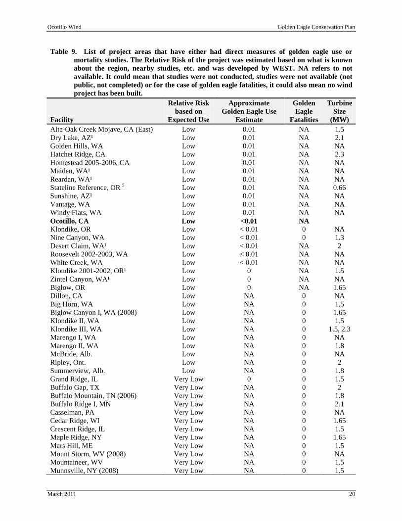
3.2 Fatality Predictions In this report, we present two different approaches for predicting the expected level of mortality for the Ocotillo facility. The first approach is similar to the approach presented in the WEST (2010) that looks at the level of mortality observed at wind projects in the western U.S. in comparison to the level of golden eagle use. As previously described, Table 4 summarizes all the observations during the large effort that occurred during the 2009 and 2010 surveys. These observations result in a golden eagle use estimate of less than 0.01 golden eagles per observation hour. Overall mean golden eagle use at the OWEF, adjusted for 20-min surveys in 2009 and 2010 is low compared with other wind-energy facilities that implemented similar protocols (Table 9). Table 9. List of project areas that have either had direct measures of golden eagle use or
mortality studies. The Relative Risk of the project was estimated based on what is known about the region, nearby studies, etc. and was developed by WEST. NA refers to not available. It could mean that studies were not conducted, studies were not available (not public, not completed) or for the case of golden eagle fatalities, it could also mean no wind project has been built.
Facility
Relative Risk based on
Expected Use
Approximate Golden Eagle Use
Estimate
Golden Eagle
Fatalities
Turbine Size
(MW) Diablo Winds CA High 0.27 2 0.66 Foote Creek Rim, WY High 0.26 1 0.6 High Winds, CA High 0.3 2 1.8 SMUD Solano, CA High NA 0 0.65 Top of the World, WY High 0.54 NA 1.5 Glenrock, WY High 0.49 NA 1.5 Campbell Hill, WY High 0.36 NA 1.5 Dunlap Ranch, WY High 0.28 NA 1.5 Elkhorn Valley, OR High 0.27 NA 1.65 Seven Mile Hill, WY High 0.26 NA 1.5 Judith Gap, MT Moderate NA 0 1.5 Antelope Ridge, OR Moderate 0.11 NA NA Morton Pass Reference, WY Moderate 0.11 NA NA Simpson Ridge (1995-1999), WY Moderate 0.1 NA NA Windy Point, WA Moderate 0.08 NA NA Cotterel Mountain, ID Moderate 0.07 NA NA High Plains, WY Moderate 0.05 NA NA Wild Horse (2002-2003), WA Moderate 0.05 0 NA CARES, WA Moderate 0.03 NA NA Klickitat County, WA Moderate 0.03 NA NA Lower Linden, WA Moderate 0.03 NA 2 Lower Snake River, WA Moderate 0.03 NA 2.3 Combine Hills, WA Moderate 0.03 0 NA Leaning Juniper, OR Low 0.02 0 1.5 Alta-Oak Creek Mojave, CA (Proper) Low 0.02 NA 1.5 Hopkins Ridge, WA Low 0.01 0 1.8 Stateline, OR/WA Low 0.01 0 0.66 Vansycle, OR Low 0.01 0 0.66
Ocotillo Wind Golden Eagle Conservation Plan
March 2011 20
Table 9. List of project areas that have either had direct measures of golden eagle use or mortality studies. The Relative Risk of the project was estimated based on what is known about the region, nearby studies, etc. and was developed by WEST. NA refers to not available. It could mean that studies were not conducted, studies were not available (not public, not completed) or for the case of golden eagle fatalities, it could also mean no wind project has been built.
Facility
Relative Risk based on
Expected Use
Approximate Golden Eagle Use
Estimate
Golden Eagle
Fatalities
Turbine Size
(MW) Alta-Oak Creek Mojave, CA (East) Low 0.01 NA 1.5 Dry Lake, AZ¹ Low 0.01 NA 2.1 Golden Hills, WA Low 0.01 NA NA Hatchet Ridge, CA Low 0.01 NA 2.3 Homestead 2005-2006, CA Low 0.01 NA NA Maiden, WA¹ Low 0.01 NA NA Reardan, WA¹ Low 0.01 NA NA Stateline Reference, OR Low 5 0.01 NA 0.66 Sunshine, AZ¹ Low 0.01 NA NA Vantage, WA Low 0.01 NA NA Windy Flats, WA Low 0.01 NA NA Ocotillo, CA Low <0.01 NA
Klondike, OR Low < 0.01 0 NA Nine Canyon, WA Low < 0.01 0 1.3 Desert Claim, WA¹ Low < 0.01 NA 2 Roosevelt 2002-2003, WA Low < 0.01 NA NA White Creek, WA Low < 0.01 NA NA Klondike 2001-2002, OR¹ Low 0 NA 1.5 Zintel Canyon, WA¹ Low 0 NA NA Biglow, OR Low 0 NA 1.65 Dillon, CA Low NA 0 NA Big Horn, WA Low NA 0 1.5 Biglow Canyon I, WA (2008) Low NA 0 1.65 Klondike II, WA Low NA 0 1.5 Klondike III, WA Low NA 0 1.5, 2.3 Marengo I, WA Low NA 0 NA Marengo II, WA Low NA 0 1.8 McBride, Alb. Low NA 0 NA Ripley, Ont. Low NA 0 2 Summerview, Alb. Low NA 0 1.8 Grand Ridge, IL Very Low 0 0 1.5 Buffalo Gap, TX Very Low NA 0 2 Buffalo Mountain, TN (2006) Very Low NA 0 1.8 Buffalo Ridge I, MN Very Low NA 0 2.1 Casselman, PA Very Low NA 0 NA Cedar Ridge, WI Very Low NA 0 1.65 Crescent Ridge, IL Very Low NA 0 1.5 Maple Ridge, NY Very Low NA 0 1.65 Mars Hill, ME Very Low NA 0 1.5 Mount Storm, WV (2008) Very Low NA 0 NA Mountaineer, WV Very Low NA 0 1.5 Munnsville, NY (2008) Very Low NA 0 1.5

Ocotillo Wind Golden Eagle Conservation Plan
March 2011 21
Table 9. List of project areas that have either had direct measures of golden eagle use or mortality studies. The Relative Risk of the project was estimated based on what is known about the region, nearby studies, etc. and was developed by WEST. NA refers to not available. It could mean that studies were not conducted, studies were not available (not public, not completed) or for the case of golden eagle fatalities, it could also mean no wind project has been built.
Facility
Relative Risk based on
Expected Use
Approximate Golden Eagle Use
Estimate
Golden Eagle
Fatalities
Turbine Size
(MW) Noble Bliss, NY Very Low NA 0 1.5 Noble Clinton, NY Very Low NA 0 1.5 Noble Ellensburg, NY Very Low NA 0 1.5 NPPD Ainsworth, NE Very Low NA 0 1.65 Top of Iowa, IA Very Low NA 0 0.9 Stetson Mountain, ME (Year 1) Very Low NA 0 1.5 1Adjusted from 30-min surveys 2Adjusted from 40-min surveys 3 Non-weighted averages of seasonal use estimates. 4Average of spring and fall surveys. 5Adjusted from 10-min surveys †
Data from the following sources: Average overall use adjusted to the number of golden eagles/20-min survey
Wind-Energy Facility Use Estimate Fatality Estimate Wind-Energy Facility Use Estimate Fatality Estimate Diablo Winds CA WEST 2006 WEST 2006, 2008 Windy Flats, WA Johnson et al. 2007c Foote Creek Rim, WY Johnson et al. 2000b Young et al. 2003c Klondike, OR Johnson et al. 2002 Johnson et al. 2003 High Winds, CA Kerlinger et al. 2005 Kerlinger et al. 2006 Nine Canyon, WA Erickson et al. 2001 Erickson et al. 2003b SMUD Solano, CA Erickson and Sharp 2005 Desert Claim, WA Young et al. 2003b Wolfe Island, Ont. (July-Dec. 09) Stantec, Ltd. 2010 Roosevelt, WA (02-03) NWC and WEST 2004 Top of the World, WY Rintz and Bay 2009 White Creek, WA NWC and WEST 2005 Glenrock, WY Johnson et al. 2008a Klondike, OR (01-02) Johnsonet al. 2002 Campbell Hill, WY Taylor et al. 2008 Zintel Canyon, WA Erickson et al. 2002a Dunlap Ranch, WY Johnson et al. 2009a Biglow, OR WEST 2005c Elkhorn Valley, OR WEST 2005b Dillon, CA Chatfield et al. 2009 Seven Mile Hill, WY Johnson et al. 2008b Big Horn, WA Kronner et al. 2008 Judith Gap, MT TRC 2008 Biglow Canyon I, WA (08) Jeffrey et al. 2009 Antelope Ridge, OR WEST 2009 Combine Hills, OR Young et al. 2006 Morton Pass Reference, WY Johnsonet al. 2000b Klondike II, WA NWC and WEST 2007 Simpson Ridge, WY(95-99) Johnsonet al. 2000b Klondike III, WA Gritski et al. 2009 Windy Point, WA Johnson et al. 2006 Marengo I, WA URS Corporation 2010a Cotterel Mountain, ID BLM 2006 Marengo II, WA URS Corporation 2010b High Plains, WY Johnson et al. 2009b McBride, Alb. Brown and Hamilton
2004 Wild Horse, WA (02-03) Erickson et al. 2003a Ripley, Ont. Jacques Whitford 2009 CARES, WA Erickson et al. 1999 Summerview, Alb. Brown and Hamilton
2006 Klickitat County, WA WEST and NWC 2003 Grand Ridge, IL Derby et al. 2009 Derby et al. 2010 Lower Linden, WA Johnson et al. 2007a Buffalo Gap, TX Tierney 2007 Lower Snake River, WA Young et al. 2009b Buffalo Mountain, TN (06) Fiedler et al. 2007 Combine Hills, WA (01-03) Young et al. 2003d Buffalo Ridge I, MN Usgaard et al. 1997,
Johnson et al. 2000a Leaning Juniper, OR Kronner at al. 2005 Kronner et al. 2007,
Gritski et al. 2008 Casselman, PA Arnett et al. 2009
Alta-Oak Creek Mojave, CA (Proper) Erickson et al. 2009 Cedar Ridge, WI BHE Environmental 2010
Hopkins Ridge, WA Young et al. 2003a Young et al. 2007a Crescent Ridge, IL Kerlinger et al. 2007 Stateline, OR/WA Erickson et al. 2002b Erickson et al. 2004 Maple Ridge, NY Jain et al. 2007, 2008,
2009c Vansycle, OR Erickson et al. 2002b Erickson et al. 2000 Mars Hill, ME Stantec 2008a Alta-Oak Creek Mojave, CA (East) Ericksonet al. 2009 Mount Storm, WV (08) Young et al. 2009a Dry Lake, AZ Young et al. 2007c Mountaineer, WV Kerns and Kerlinger
2004 Golden Hills, WA Jeffrey et al. 2008 Munnsville, NY (08) Stantec 2008b Hatchet Ridge, CA Young et al. 2007b Noble Bliss, NY Jain et al. 2009d, 2010a Homestead, CA (05-06) Johnson et al. 2007b Noble Clinton, NY Jain et al. 2009b, 2010b Maiden, WA Young et al. 2002 Noble Ellensburg, NY Jain et al. 2009a, 2010c Reardan, WA WEST 2005a NPPD Ainsworth, NE Derby et al. 2007 Stateline Reference, OR Ericksonet al. 2002b Top of Iowa, IA Jain 2005 Sunshine, AZ WEST and the CPRS 2006 Stetson Mountain, ME (Year 1) Stantec 2009 Vantage, WA WEST 2007
The information in Table 9 suggests that we would expect low golden eagle mortality in any given year at the OWEF. A conservative prediction would be an average of less than one eagle fatality per year

Ocotillo Wind Golden Eagle Conservation Plan
March 2011 22
assuming the level of use observed during the pre-construction studies continued. The likelihood of mortality in a given year would appear to be influenced by whether the territories near the project are occupied and are successful. Based on the recent past, these territories are often unoccupied and production has been very low. Another approach to estimating annual eagle fatalities at this project is to look at mortality predictions for all raptors, and then look at the percentage of raptors observed on the site that are eagles. Based on raptor use at the project (approximately 0.4/20-min survey), the estimated raptor mortality rate can be expected to be around 0.10 raptors/MW/yr. Golden eagle use comprises approximately 1/40th
of the observed raptor use, so eagle mortality is expected to be 0.0025 eagles/MW/yr or approximately one per year. This last approach is likely conservative because golden eagles are likely more detectable than other raptors and so the raptor use estimates of non-eagles are likely an overestimate of use relative to eagle use.
The final approach attempts to apply the modeling approach prescribed in the USFWS draft eagle conservation plan guidance (USFWS 2011). Table 10 and 11 contain parameters used to calculate a model of collision risk. An avoidance rate of 99% was used in the model following Whitfield (2009), since it doesn’t appear that the site (on an overall basis) has risk factors that would lead to increases in fatality (e.g., high prey base, topography, etc.).
Table 10. Values of parameters used to generate an eagle fatality estimate for the Ocotillo Wind Energy Facility. Parameter Value Eagle Use (20 min survey/2.01 km2 0.01 ) Eagle Use/min/km 0.00025 2 # minutes/observation - estimated 5 Eagle minutes/km 0.00124 2 # minutes daylight hours 262800 Area of project km 60.7 2 Exposure minutes in study area 19612 # turbines 158 risk area around turbine - km 4.96 2 danger area as a proportion of study area 0.082 Probability of collision/min flight in danger zone 0.012 non-avoidance rate 0.010 fatality rate for project - eagles per year 0.187
Table 11. Input values and calculations for the probability of collision/min flight in danger zone.
Probability of Collision if in Danger Area Value rsa - m2 10,207 area of 2-d plane (200 m x 175 m) 35,000 risk area (rsa/area of rectangle) 0.29 Approximate prob. of collision in RSA - Tucker Model 0.04 collision risk probability (product of latter two) 0.012
Using this approach, we estimate approximately one golden eagle fatality per five years (0.187 eagles per year).

Ocotillo Wind Golden Eagle Conservation Plan
March 2011 23
All three approaches lead to a predicted mortality estimate of less than one eagle per year. All three models are predicated on several assumptions, including eagle use continuing to be low as measured during the two years of pre-construction work. If nesting/territory occupancy and production were much higher than observed during the past three years in this region, then actual mortality of eagles may be higher.
3.3 Categorizing Site according to Risk Based on the USFWS draft eagle conservation plan guidance, the site specific data collected to date and the risk assessments, the OWEF appears to meet a Category 2 designation.
4.0 AVOIDANCE AND MINIMIZATION OF RISK USING ADVANCED CONSERVATION PRACTICE’S AND COMPENSATORY MITIGATION (STAGE 4) The site-specific golden eagle data collected for the OWEF suggests the site should receive a Category 2 designation according to the USFWS draft eagle conservation plan guidance. However, OE LLC plans to implement a variety of Advanced Conservation Practice’s (ACP’s) to reduce the risk to golden eagles from the project. The following ACP’s have been implemented or are planned for the OWEF during the pre-construction, construction, and operation phase of the project.
4.1 ACP’s Pre-Construction OE LLC collected available site-specific information on golden eagle use to guide project siting to avoid and minimize impacts to golden eagles. The golden eagle data collected to date does not provide strong evidence for modifying any of the preliminary turbine locations to avoid/minimize potential impacts to golden eagles. Other ACP’s implemented during the pre-construction phase of the OWEF include:
• The area and intensity of disturbances was minimized during pre-construction monitoring and testing activities.
• Existing roads and transmission corridors have been used to the extent possible while developing site plans.
• Structures are sited away from high avian use areas and the flight zones between them. • The Avian Power Line Interaction Committee (APLIC) guidance on power line siting (APLIC
1994) was followed while planning. • Site plans minimized the extent of the road network needed for the OWEF. • No lattice or structures that are attractive to birds for perching are including in facility designs. • No guy wires will be included on permanent MET towers. • Lighting plans for the facility are the minimum according to requirements. • All security lighting will be motion or heat activated, instead of being left on throughout the
night. • All security lighting will be down-shield and related to infrastructure lights. • Turbines will not be sited in areas where eagle prey species are abundant. • The facility was not sited in any areas containing high concentrations of ponds, streams, or
wetlands.
4.2 ACP’s during Construction

Ocotillo Wind Golden Eagle Conservation Plan
March 2011 24
The following ACP’s will be implemented at the OWEF during construction:
• The area and intensity of disturbance will be minimized to the extent possible during construction.
• Existing roads will be used for access during construction to the extent possible. • Non-operational MET towers will be dismantled during construction. • Powerlines will be buried to the extent possible to reduce avian collision and electrocution. • The Avian Power Line Interaction Committee (APLIC) guidance on power line construction
(APLIC 2006) will be followed. • A transportation plan will be implemented during construction that includes road design,
locations and speed limits to minimize habitat fragmentation and wildlife collisions, and minimize noise effects. This will help to minimize carrion availability for golden eagles.
• Spatial and seasonal buffers will be implemented to protect individual nest sites/territories and/or roost sites during construction, such as maintaining a buffer between activities and nests/communal roost sites and keeping natural areas between the project footprint and the nest site or communal roost by avoiding disturbance to natural landscapes.
• Human activity will be prohibited within line of site of nesting eagles to minimize disturbance.
4.3 ACP’s during Operation OE LLC plans to implement an intensive operational golden eagle monitoring and research program for the OWEF. The golden eagle monitoring and research program includes implementation of a state of the art Merlin avian radar system, radar controlled video tracking system, telemetry on any eagles nesting within four miles of the OWEF (assuming successful capture), and a full time golden eagle biological monitor to observe any golden eagles flying within the OWEF and to curtail turbines when eagles are at risk of collision. OE LLC plans to keep a staff biologist on site during the day year-round to monitor the movements of eagles and other wildlife through the site for the first five years of operations. After the completion of the first five years of monitoring operations, a decision will be made in consultation with the Technical Advisory Committee (TAC) as to whether the system will be manned seasonally and what the dates and times of operation will be to ensure a manned presence on the site when eagles could potentially be active on the site. It is the goal of OE LLC to implement a monitoring system and a compensatory mitigation package that results in no net loss of golden eagles from the OWEF over the life of its operations. Details of the intensive operational golden eagle monitoring and research program that will be implemented at OWEF are provided in Appendix C. This monitoring program is unlike anything implemented to date at a wind energy facility anywhere in the world and will not only provide a test of state of the art technological solutions and their ability to eliminate golden eagle collisions, but will also provide a unique opportunity to gain a better understanding of the interaction of golden eagles and wind energy facilities. These ACP’s and this research are likely not feasible or practical at all facilities, but given the size of this facility and other factors, there are opportunities to learn and test hypotheses regarding the effectiveness of such equipment in reducing mortality. In addition to the intensive monitoring and research program, the following ACP’s will be implemented during operation of the OWEF:
• Management activities such as seeding forbs or maintaining rock piles that attract potential prey will be avoided.
• Parts and equipment which may be used as cover by prey will not be stored in the vicinity of wind turbines.

Ocotillo Wind Golden Eagle Conservation Plan
March 2011 25
• Any carcasses (with the exception carcasses being used for post-construction bias trials) found within the OWEF will be removed immediately assuming the appropriate permits/authorizations have been granted to OE LLC.
• Responsible livestock husbandry will be practiced (e.g. removal of carcasses, fencing, calving/lambing operations will not occur in the vicinity of the wind turbines).
• Low level speed limits (< 25 mph) will be maintained on all roads within the OWEF. • Personnel will be trained to be alert for wildlife at all times, especially during low visibility
conditions. • Personnel, contractors, and visitors will be instructed to avoid disturbing wildlife, especially
during the breeding seasons and seasonal periods of stress. • Fire hazards will be reduced from vehicles and human activities (e.g., use spark arrestors on
power equipment, avoid driving vehicles off roads, and allow smoking in designated areas only). • Federal and state measures for handling toxic substances will be followed. • Effects to wetlands and water resources will be minimized by following provisions of the Clean
Water Act (1972).
4.4 Additional ACP’s The following is a list of possible ACP’s that may be considered for implementation depending on the results of the post-construction monitoring programs (both the intensive golden eagle monitoring and research program and the general post construction monitoring studies) and discussions with the Technical Advisory Committee (TAC). The post-construction monitoring program and the role of the TAC are described in further detail in Section 5 below.
• Development of a long-term (greater than three years) eagle monitoring program for the facility. • Modification and implementation of the curtailment strategies developed during the three years of
post-construction monitoring, including consideration of possibly other technologies (telemetry of eagles, cellular fence, and possible curtailment of turbines if an eagle breaches the cellular boundary.
• Seasonal or daily curtailment based on data collected on site. • Placement of visual and/or auditory bird flight diverters in critical locations. • If fossorial mammals are found burrowing near turbines, burrows may be filled and the turbine
pad may be surrounded within gravel at least two inches deep. • Installing perch guards on overhead electric lines in the vicinity of the OWEF if eagles are shown
to regularly use the lines. • Wildlife rehabilitation - Contribute funding to one or more regional raptor rehabilitation centers.
Golden eagles face threats from a variety of sources (disease, natural causes, poisoning, electrocution, power line collision, and other anthropomorphic causes), and supporting a rehabilitation center can save eagles.
• Identify highly disturbed nest sites in the region and promote and find ways to protect those nests from disturbance, which should lead to an increase in reproduction potential.
• Contribute funding for regional eagle population studies.
4.5 Re-evaluation of Risk Considering ACP’s Assuming the goal of no eagle “take” for the facility is achieved through the intensive monitoring and research program and curtailment of wind turbines anytime an eagle is flying in the vicinity of turbines, it is anticipated that the OWEF will be downgraded to a Category 3 site following the first five years of

Ocotillo Wind Golden Eagle Conservation Plan
March 2011 26
operation. The initial risk assessment is currently being used for the purposes of determining compensatory mitigation.
4.6 Compensatory Mitigation Due to the experimental nature of the radar and biological monitoring system, and some uncertainties in the likelihood of golden eagle mortality, some compensatory mitigation for retrofitting of lethal power poles will be provided. An initial commitment of funds necessary to retrofit lethal power poles to compensate for one golden eagle fatality a year for the first five years of operation will be provided using the formulas provided in the Draft Eagle Conservation Plan Guidance. Assuming $1,500 cost per pole, OEC LLC will provide $30,000 for the purpose of retrofitting lethal power poles in the region for the first five years of operation. Based on the eagle fatality estimates from the first three years of monitoring, the compensatory mitigation for the life of the project will be determined.
4.7 Cumulative Impacts
4.7.1 Population Status The population estimate for golden eagles in California, according to Blancher et al. (2007), is approximately 2,000 birds using the Breeding Bird Survey (BBS) data and the Partners in Flight (PIF) population modeling. In the western US, not including California, the population estimate was 20,722 golden eagles (90% confidence interval: 16,317 – 25,948; excluding military lands, elevations above 10,000 ft [3,048m], large water bodies, and large urban areas; Nielson et al. 2010). Based on the ratio of golden eagles aged as juveniles to the total number of golden eagles observed, it was estimated that a total of 1,962 (90% confidence interval; 1,120 – 2,930) juvenile golden eagles were present in the western US (Nielson et al. 2010). We are not aware of golden eagle population data from Imperial County, but have gathered some public data from the adjacent San Diego County. From 1997 – 2001, approximately 50-55 pairs nested in San Diego County, with approximately 20 pairs fledging young each year, and an average of 1.5 young per successful nest (Bittner 2007). The golden eagle population appears to be declining, primarily due to urban sprawl, but other factors affecting the eagles are human disturbance, especially from rock climbing, shooting, and agriculture. Powerline electrocutions are determined to be the biggest source of mortality from 1988 -2003; approximately 67% of the dead eagles picked up in and near San Diego were reported as electrocutions. Other significant factors affecting golden eagles and other raptors throughout the US include secondary poisoning and prolonged drought. Given the anticipated low level of potential eagle mortality at this site, and the ACP’s and compensatory mitigation that is being proposed, we anticipate the project to result in no net loss of golden eagles within a regional population level.
5.0 POST-CONSTRUCTION MONITORING (STAGE 5) A post-construction monitoring program will be implemented at the OWEF. The observations made during post-construction monitoring will be reported to a Technical Advisory Committee (TAC), which will respond with appropriate management decisions depending on the results of the monitoring program.

Ocotillo Wind Golden Eagle Conservation Plan
March 2011 27
Notwithstanding the foregoing, the Parties acknowledge that fatality reduction or other measures may be required pursuant to applicable law inc1uding but not limited to the federal Endangered Species Act (1973), Bald and Golden Eagle Protection. Act (1940), Migratory Bird Treaty Act (1918) or the California Endangered Species Act (California Fish and Game Code, §§ 2050, et seqJ) Since post-construction monitoring methods are constantly improving as researchers develop new and more accurate methods of survey, the TAC should consider recommendations to adopt new survey techniques and protocols as they become available. Post-construction monitoring shall include collecting field data on behavior, utilization, and distribution patterns of affected avian and bat species, in addition to fatalities.
5.1 Radar and Biological Monitoring To advance the state of knowledge in use of radar and biological monitors for risk reduction to eagles, OWEF has committed to developing, evaluating, and refining a potential system for real-time turbine curtailment at this site. These ACP’s and this research are not practical at most facilities, but given the size of this facility and other factors, there are opportunities to learn and test hypotheses regarding the effectiveness of such equipment in reducing mortality. Pattern Energy proposes having a biologist on site to monitor eagle activity in real time during the first three years of operation, and potentially up to an additional two years of operation, depending on the success of the methodologies. The air-conditioned central monitoring control room on the observation tower will be equipped with radar monitors, video monitors and controls, and radio telemetry data monitors to provide the most comprehensive site monitoring system for avian activity deployed anywhere in the world. The concept is to have multiple data sources available in real time and recorded for post event (i.e., an eagle collision with a turbine) analysis, each sensor providing important details and playing to its specific strengths and also providing redundancy. The biologist will operate during daylight hours from a central monitoring control room, mounted on a tower and affording a 360 degree panoramic view of the site. The tower, illustrated in Figure 10, will be approximately 50 feet tall. The radar used for this application will be a with an Ultra High Resolution Solid State X Band Doppler radar. The radar has a five-m Slotted Waveguide antenna with about 0.4 degrees azimuth resolution. The vertical beam width is about 24 degrees. The transmitter is a solid state with a 200-watt peak power output. The receiver uses enhanced pulse compression that produces 15-m range resolution. It is the about 0.4 degrees azimuth resolution and the 15-m range resolution that make the radar Ultra High Resolution by comparison to ANY other bird radar. The radar uses a Doppler processor with 32 Doppler filters (16 inbound and 16 outbound). The Merlin Avian Radar System uses radar tracking software which has been optimized specifically for bird tracking. This tracking software will pass off candidate eagle detections to a video monitoring system and to the biological monitor. The video cameras will be pointed in the direction of a target and then the biologist can refine the position in elevation until the target is visually acquired. Once visually acquired, the biologist can identify the target to species using very high powered binoculars and can employ video tracking software to maintain a lock on the eagle until it moves away from the site and is lost from view. The biologist will also provide a curtailment command to the operations center for the turbines if the target is projected to intersect a turbine string within the wind project. Testing will occur to determine how quickly the operations center will need to be alerted before turbine rotors can reach a low enough rpm. In addition, the biologists will investigate any observed potential turbine strikes for eagles and other raptors on the day of the observed interaction (see next section).

Ocotillo Wind Golden Eagle Conservation Plan
March 2011 28
In addition to real-time curtailment of turbines, a large amount of data will be collected to help understand golden eagle and raptor behavior and risks in an operating wind energy facility, to help validate and possibly refine the radar, video, and curtailment technologies being tested, and to provide assessments of the efficacies of these technologies for more wide spread use. Flight paths of raptors from the radar and biological monitoring will be mapped and analyzed.

Ocotillo Wind Golden Eagle Conservation Plan
March 2011 29
Figure 10. The observation tower proposed for the Ocotillo Wind Energy Facility.

Ocotillo Wind Golden Eagle Conservation Plan
March 2011 30
5.2 Fatality Monitoring OWEF will be subject to three years of post-construction monitoring unless additional monitoring is recommended and agreed upon by OE LLC. Post-construction monitoring shall begin no later than three (3) months after the beginning of operations. Any golden eagle mortalities will be identified through the post-construction monitoring effort. These surveys will be completed regularly to document the number and species of bird and bat fatalities attributable to the OWEF. The methods for estimating mortality at the OWEF will conform with industry standards in the U.S. As part of these mortality surveys, the searcher efficiency rate (i.e., the ability of a surveyor to locate a mortality) and carcass removal rate (i.e., the average time that a carcass persists before a scavenger removes it) will be determined for bats and small and large bird size classes. OWEF will monitor a subset of 30% of the turbines at least twice per month for the first two years of operation to quantify bird and bat mortality. During the third year of monitoring, the focus will be strictly on quantifying eagle and raptor mortality. Monthly searches will be conducted at the sample of turbines during this third year, focusing on quantifying raptor mortality. In addition to the standardized monitoring, all observations of likely collision of raptors with wind turbines documented through the radar and biological monitoring will be investigated. During the same day the interaction was documented, a technician will search the turbines where the interaction occurred.
5.3 Golden Eagle Nest Surveys Golden eagle nest surveys will be conducted prior to the nesting season and once each month during the nesting season during the first three years of operations. Aerial or ground based golden eagle nest surveys will be conducted within a 10-mile buffer of the project area focused on suitable nesting habitat, based on current USFWS guidance. The complete 10-mile search area will be limited to once at the beginning of the golden eagle nesting season, with monthly follow-up surveys only being completed for identified golden eagle or potential golden eagle nests. Nest locations found during surveys will be documented by noting the species, dates of activity, Universal Transverse Mercator (UTM) NAD 83 coordinates, nest contents (when possible), and behavior. The data will be presented to the TAC to determine whether mitigation should be recommended to reduce impacts to nesting activities. Active golden eagle nests will be monitored to track the breeding success of resident golden eagles and to evaluate the effectiveness of the mitigation measures that have been applied.
5.4 Reporting The Monitor shall prepare interim, annual monitoring reports within three months of completing each year of post-construction monitoring, and shall prepare a final three year Monitoring Report within six months of completing three years of post-construction monitoring. All monitoring reports, including all raw monitoring data upon which the reports are based, shall be made available to members of the TAC. All monitoring reports shall report adjusted and unadjusted annual fatalities for bats and all other bird species on a per-turbine and per-megawatt basis. The monitoring reports shall also summarize the results of the bird and bat behavior and use studies for the preceding one or three years, as applicable. The Monitor shall supplement the final three year Monitoring Report with subsequent monitoring data collected.
6.0 ADAPTIVE MANAGEMENT The adaptive management techniques described in this section have been developed to ensure that potentially significant levels of mortality from operation of the OWEF are effectively mitigated. This

Ocotillo Wind Golden Eagle Conservation Plan
March 2011 31
section describes the adaptive management process that will be applied for avian and bat species. Changes in federal, state, and/or BLM status for wildlife species occurring within the project area may result in the addition of, or changes to, adaptive management strategies, as determined by the BLM through TAC recommendations.
6.1 Adaptive Management Process The TAC Lead will be provided a running mortality count every two weeks for review. The TAC will meet to discuss mitigation needs if the TAC Lead determines that a unique or significant event has occurred. At a minimum, the TAC will meet annually to review data and determine whether mitigation is necessary. If the TAC determines mitigation is necessary, the TAC will be responsible for identifying and recommending suitable mitigation(s). One or more mitigation measures may be applied for birds or bats if a unique or significant event occurs. Measures to consider are found in section 4.4.
6.2 Agency Interaction The development of an effective and successful ECP for the OWEF will depend on frequent coordination between agency biologists and OE LLC. Many of the ACP’s implemented at OWEF will be tested for the first time and will need to be reviewed and evaluated for effectiveness. As the OWEF will likely be one of the first projects that implements the USFWS draft ECP guidance (2011), it is anticipated that the process will evolve and that modifications to the process may need to be made while ensuring that the goal of stable or increasing breeding populations of eagles is achieved. As suggested in the USFWS draft ECP guidance, OC LLC, plans to allow service personnel access to the site to monitor the effects and effectiveness of the ACP’s and mitigation measures that have been implemented.
7.0 PUBLIC OUTREACH OWEF will coordinate with key interest groups within the community to determine how capital contributions from the project can go toward local scholarship funds and/or worthwhile community projects. In addition, a project fact sheet describing the project and measures that have been put in place to address avian and bat issues will be prepared and made available at the local BLM El Centro District Office.
8.0 CONCLUSION This document was written to provide guidance for all required wildlife mitigation and monitoring prior to, during, and after construction of the OWEF. The measures described in this document are intended to help protect and reduce impacts to wildlife, as well as to monitor potential impacts to wildlife following implementation of the OWEF. It is anticipated that this Avian and Bat Protection Plan (ABPP) will adaptively manage the OWEF based on findings following construction.
9.0 LITERATURE CITED Arnett, E.B., M.R. Schirmacher, M.M.P. Huso, and J.P. Hayes. 2009. Patterns of Bat Fatality at the
Casselman Wind Project in South-Central Pennsylvania. Annual Report Prepared for the Bats and Wind Energy Cooperative (BWEC) and the Pennsylvania Game Commission. June 2009. http://www.batsandwind.org/pdf/2008%20Casselman%20Fatality%20Report.pdf

Ocotillo Wind Golden Eagle Conservation Plan
March 2011 32
Aspen Environmental Group. 2008. Final Environmental Impact Report/Environmental Impact Statement and Proposed Land Use Amendment, San Diego Gas and Electric Company Application for the Sunrise Powerlink Project. SCH #2006091071. DOI Control No. FES-08-54. California Public Utilities Commission (PUC) and US Department of Interior, Bureau of Land Management (USDOI-BLM). October 2008.
Avian Power Line Interaction Committee (APLIC). 1994. Mitigating Bird Collisions with Power Lines: The State of the Art in 1994. Edison Electric Institute. Washington, D.C.
Avian Power Line Interaction Committee (APLIC). 2006. Suggested Practices for Avian Protection on Power Lines: The State of the Art in 2006. Public Interest Energy Research Program (PIER) Final Project Report CEC-500-2006-022. Edison Electric Institute, APLIC, and the California Energy Commission. Washington D.C. and Sacramento, California.
Bald and Golden Eagle Protection Act (BGEPA). 1940. 16 United States Code § 668-668d. June 8, 1940.
Barclay, R.M.R., E.F. Baerwald, and J.C. Gruver. 2007. Variation in Bat and Bird Fatalities at Wind Energy Facilities: Assessing the Effects of Rotor Size and Tower Height. Canadian Journal of Zoology 85: 381-387. http://www.bio.ucalgary.ca/contact/faculty/pdf/Barclay07Tur.pdf
Barrios, L. and A. Rodriguez. 2004. Behavior and Environmental Correlates of Soaring-Bird Mortality at on-Shore Wind Turbines. Journal of Applied Ecology 41: 72-81.
BHE Environmental, Inc. (BHE). 2010. Post-Construction Bird and Bat Mortality Study: Cedar Ridge Wind Farm, Fond Du Lac County, Wisconsin. Interim Report prepared for Wisconsin Power and Light, Madison, Wisconsin. Prepared by BHE Environmental, Inc. Cincinnati, Ohio. February 2010.
Bittner. 2007. Personal Communication with Wildlife Research Institute, as Reported by Aspen Environmental Group 2008.
Blancher, P.J., K.V. Rosenberg, A.O. Panjabi, B. Altman, J. Bart, C.J. Beardmore, G.S. Butcher, D. Demarest, R. Dettmers, E.H. Dunn, W. Easton, W.C. Hunter, E.E. Iñigo-Elias, D.N. Pashley, C.J. Ralph, T.D. Rich, C.M. Rustay, J.M. Ruth, and T.C. Will. 2007. Guide to the Partners in Flight Population Estimates Database. Version: North American Landbird Conservation Plan 2004. Partners in Flight Technical Series No 5. http://www.partnersinflight.org/
Brown, W.K. and B.L. Hamilton. 2004. Bird and Bat Monitoring at the Mcbride Lake Wind Farm, Alberta, 2003-2004. Report for Vision Quest Windelectric, Inc., Calgary, Alberta, Canada. September 2004.
Brown, W.K. and B.L. Hamilton. 2006. Monitoring of Bird and Bat Collisions with Wind Turbines at the Summerview Wind Power Project, Alberta: 2005-2006. Prepared for Vision Quest Windelectric, Calgary, Alberta by TAEM Ltd., Calgary, Alberta, and BLH Environmental Services, Pincher Creek, Alberta. September 2006. http://www.batsandwind.org/pdf/Brown2006.pdf
Bureau of Land Management (BLM). 2006. Final Environmental Impact Statement for the Proposed Cotterel Wind Power Project and Proposed Resource Management Plan Amendment. FES 06-07. US Department of the Interior (USDOI), BLM, Twin Falls District, Burley Field Office, Cassia County, Idaho. March 2006.
Bureau of Land Management (BLM). 2010. Instruction Memorandum No. 2010-156. Bald and Golden Eagle Protection Act – Golden Eagle National Environmental Policy Act and Avian Protection Plan Guidance for Renewable Energy. July 13, 2010. Expires September 30, 2011. Available online at: http://www.blm.gov/wo/st/en/info/regulations/Instruction_Memos_and_Bulletins/national_instruction/2010/IM_2010-156.html

Ocotillo Wind Golden Eagle Conservation Plan
March 2011 33
California Department of Fish and Game (CDFG). 1984. California Endangered Species Act. Available Online at: http://www.leginfo.ca.gov/cgi-bin/displaycode?section=fgc&group=02001-03000&file=2050-2069
California Energy Commission (CEC) and California Department of Fish and Game (CDFG). 2007. California Guidelines for Reducing Impacts to Birds and Bats from Wind Energy Development. . Commission Final Report. California Energy Commission, Renewables Committee, and Energy Facilities Siting Division, and California Department of Fish and Game, Resources Management and Policy Division. CEC-700-2007-008-CMF.
Chamberlain, D.E., M.R. Rehfisch, A.D. Fox, M. Desholm, and S.J. Anthony. 2006. The Effect of Avoidance Rates on Bird Mortality Predictions Made by Wind Turbine Collision Risk Models. Ibis 148(S1): 198-202.
Chatfield, A., W. Erickson, and K. Bay. 2009. Avian and Bat Fatality Study, Dillon Wind-Energy Facility, Riverside County, California. Final Report: March 26, 2008 - March 26, 2009. Prepared for Iberdrola Renewables, Portland, Oregon. Prepared by Western EcoSystems Technology, Inc. (WEST), Cheyenne, Wyoming. June 3, 2009.
Clean Water Act (CWA). 1972. Clean Water Act. October 18, 1972. 33 United States Code § 1251-1387, 1251 et seq., 2000.
De Lucas, M., G.F.E. Janss, and M. Ferrer, eds. 2007. Birds and Wind Farms: Risk Assessment and Mitigation. Quercus. 275 pp.
Derby, C., K. Bay, and J. Ritzert. 2009. Bird Use Monitoring, Grand Ridge Wind Resource Area, La Salle County, Illinois. Year One Final Report, March 2008 - February 2009. Prepared for Grand Ridge Energy LLC, Chicago, Illinois. Prepared by Western EcoSystems Technology, Inc. (WEST), Cheyenne, Wyoming. July 29, 2009.
Derby, C., A. Dahl, W. Erickson, K. Bay, and J. Hoban. 2007. Post-Construction Monitoring Report for Avian and Bat Mortality at the Nppd Ainsworth Wind Farm. Unpublished report prepared by Western EcoSystems Technology, Inc. (WEST), Cheyenne, Wyoming, for the Nebraska Public Power District.
Derby, C., J. Ritzert, and K. Bay. 2010. Bird and Bat Fatality Study, Grand Ridge Wind Resource Area, Lasalle County, Illinois. January 2009 - January 2010. Prepared for Grand Ridge Energy LLC, Chicago, Illinois. Prepared by Western EcoSystems Technology, Inc. (WEST), Bismarck, North Dakota. July 13, 2010. Revised January 2011.
Endangered Species Act (ESA). 1973. 16 United States Code § 1531-1544. December 28, 1973.
Erickson, W.P., A. Chatfield, and K. Bay. 2009. Baseline Avian Studies for the Alta-Oak Creek Mojave Wind Resource Area, Kern County, California. Final Report: February 4 - June 30, 2010. Prepared for CH2M HILL, Oakland, California. Prepared by Western EcoSystems Technology, Inc. (WEST), Cheyenne, Wyoming.
Erickson, W.P., D.P. Young, Jr., G. Johnson, J. Jeffrey, K. Bay, R. Good, and H. Sawyer. 2003a. Wildlife Baseline Study for the Wild Horse Wind Project. Summary of Results from 2002-2003 Wildlife Surveys May 10, 2002- May 22, 2003. Draft report prepared for Zilkha Renewable Energy, Portland, Oregon. Prepared by Western EcoSystems Technology, Inc. (WEST), Cheyenne, Wyoming. November 2003.
Erickson, W.P., J. Jeffrey, K. Kronner, and K. Bay. 2004. Stateline Wind Project Wildlife Monitoring Annual Report. July 2001 - December 2003. Technical report peer-reviewed by and submitted to FPL Energy, the Oregon Energy Facility Siting Council, and the Stateline Technical Advisory CommitteeWestern EcoSystems Technology, Inc., Cheyenne, Wyoming. December 2004.

Ocotillo Wind Golden Eagle Conservation Plan
March 2011 34
Erickson, W.P., G.D. Johnson, K. Bay, and K. Kronner. 2002a. Ecological Baseline Study for the Zintel Canyon Wind Project. Final Report April 2001 – June 2002. Technical report prepared for Energy Northwest. Prepared for Energy Northwest by Western EcoSystems Technology, Inc. (WEST), Cheyenne, Wyoming, and Northwest Wildlife Consultants, Inc. (NWC), Pendleton, Oregon. June 2002.
Erickson, W.P., G.D. Johnson, D.P. Young, Jr., D. Strickland, R. Good, M. Bourassa, K. Bay, and K. Sernka. 2002b. Synthesis and Comparison of Baseline Avian and Bat Use, Raptor Nesting and Mortality Information from Proposed and Existing Wind Developments. Technical report prepared for Bonneville Power Administration, Portland, Oregon by WEST, Inc., Cheyenne, Wyoming. December 2002. http://www.bpa.gov/Power/pgc/wind/Avian_and_Bat_Study_12-2002.pdf
Erickson, W.P., G.D. Johnson, M.D. Strickland, and K. Kronner. 2000. Avian and Bat Mortality Associated with the Vansycle Wind Project, Umatilla County, Oregon: 1999 Study Year. Technical report prepared by WEST, Inc. for Umatilla County Department of Resource Services and Development, Pendleton, Oregon. 21pp. http://www.west-inc.com/reports/vansyclereportnet.pdf
Erickson, W.P., G.D. Johnson, M.D. Strickland, K. Kronner, P.S. Becker, and S. Orloff. 1999. Baseline Avian Use and Behavior at the Cares Wind Plant Site, Klickitat County, Washington. NREL/SR-500-26902. Final report prepared by Western EcoSystems Technology, Inc. (WEST), Cheyenne, Wyoming, and IBIS Environmental Services, San Rafael, California.
Erickson, W.P., K. Kronner, and B. Gritski. 2003b. Nine Canyon Wind Power Project Avian and Bat Monitoring Report. September 2002 – August 2003. Prepared for the Nine Canyon Technical Advisory Committee and Energy Northwest by Western EcoSystems Technology, Inc. (WEST), Cheyenne, Wyoming, and Northwest Wildlife Consultants (NWC), Pendleton, Oregon. October 2003. http://www.west-inc.com/reports/nine_canyon_monitoring_final.pdf
Erickson, W.P., E. Lack, M. Bourassa, K. Sernka, and K. Kronner. 2001. Wildlife Baseline Study for the Nine Canyon Wind Project, Final Report May 2000-October 2001 Technical report prepared for Energy Northwest, Richland, Washington.
Erickson, W.P. and L. Sharp. 2005. Phase 1 and Phase 1a Avian Mortality Monitoring Report for 2004-2005 for the Smud Solano Wind Project. Prepared for Sacramento Municipal Utility District (SMUD), Sacramento, California. Prepared by URS Sacramento, California and Western EcoSystems Technology, Inc. (WEST). August 2005.
Federal Register. 1974. 50 Code of Federal Regulations (CFR) Part 13. Title 50 - Wildlife and Fisheries, Chapter I -United States Fish and Wildlife Service, Department of the Interior, Subchapter B - Taking, Possession, Transportation, Sale, Purchase, Barter, Exportation, and Importation of Wildlife and Plants, Part 13 - General Permit Procedures.
Federal Register. 1974. 50 Code of Federal Regulations (CFR) Part 22. Title 50 - Wildlife and Fisheries, Chapter I -United States Fish and Wildlife Service, Department of the Interior, Subchapter B - Taking, Possession, Transportation, Sale, Purchase, Barter, Exportation, and Importation of Wildlife and Plants, Part 22 - Eagle Permits. January 4, 1974, as amended.
Fiedler, J.K., T.H. Henry, R.D. Tankersley, and C.P. Nicholson. 2007. Results of Bat and Bird Mortality Monitoring at the Expanded Buffalo Mountain Windfarm, 2005. Tennessee Valley Authority. June 28, 2007.
Gritski, B., S. Downes, and K. Kronner. 2009. Klondike Iii (Phase 1) Wind Power Project Wildlife Monitoring Year One Summary, October 2007-October 2008. Prepared for Iberdrola Renewables, Portland, Oregon. Prepared by Northwest Wildlife Consultants, Inc. (NWC), Pendleton, Oregon. April 3, 2009.

Ocotillo Wind Golden Eagle Conservation Plan
March 2011 35
Gritski, B., K. Kronner, and S. Downes. 2008. Leaning Juniper Wind Power Project, 2006 − 2008. Wildlife Monitoring Final Report. Prepared for PacifiCorp Energy, Portland, Oregon. Prepared by Northwest Wildlife Consultants, Inc. (NWC), Pendleton, Oregon. December 30, 2008.
HELIX Environmental Planning, Inc. 2010a. Avian Point Count Report for the Ocotillo Wind Energy Project. AEG-09. December 10, 2010.
HELIX Environmental Planning, Inc. 2010b. Raptor Migration Report for the Ocotillo Wind Energy Project. AEG-09. December 10, 2010.
HELIX Environmental Planning, Inc. 2011. Results of Fall 2010 Golden Eagle Counts for the Ocotillo Wind Energy Project. Unpublished data.
Hoover, S.L. and M.L. Morrison. 2005. Behavior of Red-Tailed Hawks in a Wind Turbine Development. Journal of Wildlife Management 69(1): 150-159.
Hunt, W.G. 2002. Golden Eagles in a Perilous Landscape: Predicting the Effects of Mitigation for Wind Turbine Bladestrike Mortality. California Energy Commission (CEC) Consultant Report P500-02-043F, CEC Sacramento, California. July 2002. Prepared for CEC, Public Interest Energy Research (PIER), Sacramento, California, by University of California, Santa Cruz, California. http://www.energy.ca.gov/reports/2002-11-04_500-02-043F.PDF
Jacques Whitford Stantec Limited (Jacques Whitford). 2009. Ripley Wind Power Project Postconstruction Monitoring Report. Project No. 1037529.01. Report to Suncor Energy Products Inc., Calgary, Alberta, and Acciona Energy Products Inc., Calgary, Alberta. Prepared for the Ripley Wind Power Project Post-Construction Monitoring Program. Prepared by Jacques Whitford, Markham, Ontario. April 30, 2009. www.jacqueswhitford.com
Jain, A. 2005. Bird and Bat Behavior and Mortality at a Northern Iowa Windfarm. M.S. Thesis. Iowa State University, Ames, Iowa.
Jain, A., P. Kerlinger, R. Curry, and L. Slobodnik. 2007. Annual Report for the Maple Ridge Wind Power Project: Post-Construction Bird and Bat Fatality Study – 2006. Final Report. Prepared for PPM Energy and Horizon Energy and Technical Advisory Committee (TAC) for the Maple Ridge Project Study.
Jain, A., P. Kerlinger, R. Curry, and L. Slobodnik. 2008. Annual Report for the Maple Ridge Wind Power Project: Post-Construction Bird and Bat Fatality Study - 2007. Final report prepared for PPM Energy and Horizon Energy and Technical Advisory Committee (TAC) for the Maple Ridge Project Study.
Jain, A., P. Kerlinger, R. Curry, L. Slobodnik, A. Fuerst, and C. Hansen. 2009a. Annual Report for the Noble Ellenburg Windpark, LLC, Postconstruction Bird and Bat Fatality Study - 2008. Prepared for Noble Environmental Power, LLC by Curry and Kerlinger, LLC. April 13, 2009.
Jain, A., P. Kerlinger, R. Curry, L. Slobodnik, J. Histed, and J. Meacham. 2009b. Annual Report for the Noble Clinton Windpark, LLC, Postconstruction Bird and Bat Fatality Study - 2008. Prepared for Noble Environmental Power, LLC by Curry and Kerlinger, LLC. April 13, 2009.
Jain, A., P. Kerlinger, R. Curry, L. Slobodnik, and M. Lehman. 2009c. Maple Ridge Wind Power Avian and Bat Fatality Study Report - 2008. Annual Report for the Maple Ridge Wind Power Project, Post-construction Bird and Bat Fatality Study - 2008. Prepared for Iberdrola Renewables, Inc, Horizon Energy, and the Technical Advisory Committee (TAC) for the Maple Ridge Project Study. Prepared by Curry and Kerlinger, LLC. May 14, 2009.
Jain, A., P. Kerlinger, R. Curry, L. Slobodnik, J. Quant, and D. Pursell. 2009d. Annual Report for the Noble Bliss Windpark, LLC, Postconstruction Bird and Bat Fatality Study - 2008. Prepared for Noble Environmental Power, LLC by Curry and Kerlinger, LLC. April 13, 2009.

Ocotillo Wind Golden Eagle Conservation Plan
March 2011 36
Jain, A., P. Kerlinger, L. Slobodnik, R. Curry, A. Fuerst, and A. Harte. 2010a. Annual Report for the Noble Bliss Windpark, Llc: Postconstruction Bird and Bat Fatality Study - 2009. Prepared for Noble Environmental Power, LLC. Prepared by Curry and Kerlinger, LLC, Cape May, New Jersey. March 9, 2010.
Jain, A., P. Kerlinger, L. Slobodnik, R. Curry, and K. Russell. 2010b. Annual Report for the Noble Clinton Windpark, LLC: Postconstruction Bird and Bat Fatality Study - 2009. Prepared for Noble Environmental Power, LLC. Prepared by Curry and Kerlinger, LLC, Cape May, New Jersey. March 9, 2010.
Jain, A., P. Kerlinger, L. Slobodnik, R. Curry, and K. Russell. 2010c. Annual Report for the Noble Ellenburg Windpark, Llc: Postconstruction Bird and Bat Fatality Study - 2009. Prepared for Noble Environmental Power, LLC. Prepared by Curry and Kerlinger, LLC, Cape May, New Jersey. March 14, 2010.
Jeffrey, J.D., K. Bay, W.P. Erickson, M. Sonneberg, J. Baker, M. Kesterke, J. Boehrs, and A. Palochak. 2009. Portland General Electric Biglow Canyon Wind Farm Phase I Post-Construction Avian and Bat Monitoring First Annual Report, Sherman County, Oregon. January 2008 - December 2008. Technical report prepared for Portland General Electric Company, Portland, Oregon. Prepared by Western EcoSystems Technology (WEST) Inc., Cheyenne, Wyoming, and Walla Walla, Washington. April 29, 2009.
Jeffrey, J.D., W.P. Erickson, K.J. Bay, V.K. Poulton, W.L. Tidhar, and J.E. Baker. 2008. Wildlife Baseline Studies for the Golden Hills Wind Resource Area, Sherman County, Oregon. Final Report May 2006 – October 2007. Prepared for BP Alternative Energy North America Inc., Houston, Texas, by Western EcoSystems Technology, Inc. (WEST), Cheyenne, Wyoming.
Johnson, G.D., J. Baker, and K. Bay. 2007a. Baseline Ecological Studies for the Lower Linden Ranch Wind Energy Project, Klickitat County, Washington. Prepared by Western EcoSystems Technology, Inc. (WEST), Cheyenne, Wyoming, for Northwest Wind Partners, LLC, Goldendale, Washington. July 18, 2007.
Johnson, G.D., K. Bay, and J. Eddy. 2009a. Wildlife Baseline Studies for the Dunlap Ranch Wind Resource Area, Carbon and Albany Counties, Wyoming. June 4, 2008 - May 27, 2009. Prepared for CH2MHILL, Englewood, Colorado. Prepared by Western EcoSystems Technology, Inc. (WEST), Cheyenne, Wyoming.
Johnson, G.D., K. Bay, and J. Eddy. 2009b. Wildlife Baseline Studies for the High Plains Wind Resource Area, Carbon and Albany Counties, Wyoming. Prepared for CH2MHILL. Prepared by Western EcoSystems Technology, Inc. (WEST), Cheyenne, Wyoming.
Johnson, G.D., K. Bay, J. Eddy, and T. Rintz. 2008a. Wildlife Baseline Studies for the Glenrock Wind Resource Area, Converse County, Wyoming. Prepared for CH2MHILL. Prepared by Western EcoSystems Technology, Inc. (WEST), Cheyenne, Wyoming.
Johnson, G.D., J. Eddy, K. Bay, and A. Chatfield. 2008b. Wildlife Baseline Studies for the Seven Mile Hill Wind Resource Area, Carbon County, Wyoming: April 30 - November 15, 2007. Prepared for CH2MHILL, Englewood, Colorado. Prepared by Western EcoSystems Technology, Inc. (WEST), Cheyenne, Wyoming.
Johnson, G.D., W.P. Erickson, K. Bay, and K. Kronner. 2002. Baseline Ecological Studies for the Klondike Wind Project, Sherman County, Oregon. Final report prepared for Northwestern Wind Power, Goldendale, Washington, by Western EcoSystems Technology, Inc. (WEST) Cheyenne, Wyoming, and Northwest Wildlife Consultants, Inc. (NWC), Pendleton, Oregon. May 29, 2002.

Ocotillo Wind Golden Eagle Conservation Plan
March 2011 37
Johnson, G.D., W.P. Erickson, K. Bay, C. Nations, J. Kerns, E. Riley, and P. Bloom. 2007b. Baseline Avian Use and Risk Assessment for the Homestead Wind Energy Project, Kern County, California. 2005 – 2006. Prepared for Horizon Wind Energy by Western EcoSystems Technology, Inc. (WEST), Cheyenne, Wyoming; EDAW, Inc., San Diego, California; and Bloom Biological, Inc., Santa Anna, California. April 19, 2007.
Johnson, G.D., W.P. Erickson, and J.D. Jeffrey. 2006. Analysis of Potential Wildlife Impacts from the Windy Point Wind Energy Project, Klickitat County, Washington. Unpublished report prepared by Western EcoSystems Technology, Inc. (WEST), Cheyenne, Wyoming. February 3, 2006.
Johnson, G.D., W.P. Erickson, M.D. Strickland, M.F. Shepherd, and D.A. Shepherd. 2000a. Avian Monitoring Studies at the Buffalo Ridge Wind Resource Area, Minnesota: Results of a 4-Year Study. Final report prepared for Northern States Power Company, Minneapolis, Minnesota, by Western EcoSystems Technology, Inc. (WEST), Cheyenne, Wyoming. September 22, 2000. 212 pp. http://www.west-inc.com
Johnson, G.D., W.P. Erickson, and J. White. 2003. Avian and Bat Mortality During the First Year of Operation at the Klondike Phase I Wind Project, Sherman County, Oregon. March 2003. Technical report prepared for Northwestern Wind Power, Goldendale, Washington, by Western EcoSystems Technology, Inc. (WEST), Cheyenne, Wyoming. http://www.west-inc.com
Johnson, G.D., J. Jeffrey, J. Baker, and K. Bay. 2007c. Baseline Avian Studies for the Windy Flats Wind Energy Project, Klickitat County, Washington. Prepared for Windy Point Partners, LLC., by Western EcoSystems Technology, Inc. (WEST), Cheyenne, Wyoming. May 29, 2007.
Johnson, G.D., D.P. Young, W.P. Erickson, C.E. Derby, M.D. Strickland, and R.E. Good. 2000b. Wildlife Monitoring Studies, Seawest Windpower Plant, Carbon County, Wyoming, 1995-1999. Final report prepared for SeaWest Energy Corporation, San Diego, California, and the Bureau of Land Management, Rawlins, Wyoming, by Western EcoSystems Technology, Inc. (WEST), Cheyenne, Wyoming. August 9, 2000. http://www.west-inc.com and http://www.west-inc.com/reports/fcr_final_baseline.pdf
Kerlinger, P., L. Culp, and R. Curry. 2005. Post-Construction Avian Monitoring Study for the High Winds Wind Power Project, Solano County, California. Year One Report. Prepared for High Winds, LLC and FPL Energy.
Kerlinger, P., R. Curry, L. Culp, A. Jain, C. Wilkerson, B. Fischer, and A. Hasch. 2006. Post-Construction Avian and Bat Fatality Monitoring for the High Winds Wind Power Project, Solano County, California: Two Year Report. Prepared for High Winds LLC, FPL Energy by Curry and Kerlinger, LLC. April 2006.
Kerlinger, P., R. Curry, A. Hasch, and J. Guarnaccia. 2007. Migratory Bird and Bat Monitoring Study at the Crescent Ridge Wind Power Project, Bureau County, Illinois: September 2005 - August 2006. Final draft prepared for Orrick Herrington and Sutcliffe, LLP. May 2007.
Kerns, J. and P. Kerlinger. 2004. A Study of Bird and Bat Collisions at the Mountaineer Wind Energy Facility, Tucker County, West Virginia: Annual Report for 2003. Prepared for FPL Energy and the Mountaineer Wind Energy Center Technical Review Committee. February 14, 2004. Technical report prepared by Curry and Kerlinger, LLC., for FPL Energy and Mountaineer Wind Energy Center Technical Review Committee. Curry and Kerlinger, LLC. 39 pp. http://www.wvhighlands.org/Birds/MountaineerFinalAvianRpt-%203-15-04PKJK.pdf
Kronner, K., B. Gritski, J. Baker, V. Marr, G.D. Johnson, and K.Bay. 2005. Wildlife Baseline Study for the Leaning Juniper Wind Power Project, Gilliam County, Oregon. Prepared for PPM Energy, Portland, Oregon and CH2MHILL, Portland, Oregon by NWC, Pendleton, Oregon, and WEST, Inc., Cheyenne, Wyoming. November 3, 2005.

Ocotillo Wind Golden Eagle Conservation Plan
March 2011 38
Kronner, K., B. Gritski, and S. Downes. 2008. Big Horn Wind Power Project Wildlife Fatality Monitoring Study: 2006−2007. Final report prepared for PPM Energy and the Big Horn Wind Project Technical Advisory Committee by Northwest Wildlife Consultants, Inc. (NWC), Mid-Columbia Field Office, Goldendale, Washington. June 1, 2008.
Kronner, K., B. Gritski, Z. Ruhlen, and T. Ruhlen. 2007. Leaning Juniper Phase I Wind Power Project, 2006-2007: Wildlife Monitoring Annual Report. Unpublished report prepared by Northwest Wildlife Consultants, Inc. for PacifiCorp Energy, Portland, Oregon.
Migratory Bird Treaty Act (MBTA). 1918. 16 United States Code § 703-712. July 13, 1918.
National Land Cover Database (NLCD). 2001. Landuse/Landcover Nlcd 2001. USGS Headquarters, USGS National Center. Reston, Virginia.
Nielson, R.M., T. Rintz, M.B. Stahl, R.E. Good, L.L. McDonald, and T.L. McDonald. 2010. Results of the 2009 Survey of Golden Eagles (Aquila Chrysaetos) in the Western United States. A. Contract #201818C027. Prepared for the US Fish and Wildlife Service (USFWS), Virginia. Prepared by Western EcoSystems Technology, Inc. (WEST), Cheyenne, Wyoming, ed. January 7, 2010. Available online at: http://www.west-inc.com/reports/2009GoldenEagleSurvey.pdf
Northwest Wildlife Consultants, Inc. (NWC) and Western Ecosystems Technology, Inc. (WEST). 2004. Ecological Baseline Studies for the Roosevelt Wind Project, Klickitat County, Washington. Final Report. Prepared by NWC, Pendleton, Oregon, and WEST, Inc., Cheyenne, Wyoming. September 2004
Northwest Wildlife Consultants, Inc. (NWC) and Western Ecosystems Technology, Inc. (WEST). 2005. Ecological Baseline Studies and Wildlife Impact Assessment for the White Creek Wind Power Project, Klickitat County, Washington. Prepared for Last Mile Electric Cooperative, Goldendale, Washington, by Northwest Wildlife Consultants, Inc., Goldendale, Washington, and Western EcoSystems Technology, Inc. (WEST), Cheyenne, Wyoming. January 12, 2005.
Northwest Wildlife Consultants, Inc. (NWC) and Western EcoSystems Technology, Inc. (WEST). 2007. Avian and Bat Monitoring Report for the Klondike Ii Wind Power Project. Sherman County, Oregon. Prepared for PPM Energy, Portland, Oregon. Managed and conducted by NWC, Pendleton, Oregon. Analysis conducted by WEST, Cheyenne, Wyoming. July 17, 2007.
Pagel, J.E., D.M. Whittington, and G.T. Allen. 2010. Interim Golden Eagle Technical Guidance: Inventory and Monitoring Protocols; and Other Recommendations in Support of Golden Eagle Management and Permit Issuance. US Fish and Wildlife Service (USFWS). February 2010. Available online at: http://steinadlerschutz.lbv.de/fileadmin/www.steinadlerschutz.de/terimGoldenEagleTechnicalGuidanceProtocols25March2010_1_.pdf
Rintz, T. and K. Bay. 2009. Wildlife Baseline Studies for the Top of the World Wind Resource Area, Converse County, Wyoming. Final Report: March 21, 2008 - May 26, 2009. Prepared for Duke Energy Corporation, dba Top of the World Wind Energy, LLC, Rutland, Vermont. Prepared by:Western EcoSystems Technology, Inc. (WEST), Cheyenne, Wyoming.
Smallwood, K.S. 2007. Estimating Wind Turbine-Caused Bird Mortality. Journal of Wildlife Management 71: 2781-2791.
Smallwood, K.S. and B. Karas. 2009. Avian and Bat Fatality Rates at Old-Generation and Repowered Wind Turbines in California. Journal of Wildlife Management 73(7): 1062-1071.
Smallwood, K.S., L. Rugge, and M.L. Morrison. 2009. Influence of Behavior on Bird Mortality in Wind Energy Developments. Journal of Wildlife Management 73(7): 1082–1098.

Ocotillo Wind Golden Eagle Conservation Plan
March 2011 39
Smallwood, K.S. and C.G. Thelander. 2004. Developing Methods to Reduce Bird Fatalities in the Altamont Wind Resource Area. Final report prepared by BioResource Consultants for the California Energy Commission, Public Interest Energy Research-Environmental Area, under Contract No. 500-01-019 (L. Spiegel, Project Manager).
Stantec Consulting, Inc. (Stantec). 2008a. 2007 Spring, Summer, and Fall Post-Construction Bird and Bat Mortality Study at the Mars Hill Wind Farm, Maine. Prepared for UPC Wind Management, LLC, Cumberland, Maine, by Stantec Consulting, formerly Woodlot Alternatives, Inc., Topsham, Maine. January, 2008.
Stantec Consulting, Inc. (Stantec). 2008b. Post-Construction Monitoring at the Munnsville Wind Farm, New York: 2008. Prepared for E.ON Climate and Renewables, Austin, Texas. Prepared by Stantec Consulting, Topsham, Maine. January 2009.
Stantec Consulting, Inc. (Stantec). 2009. Stetson I Mountain Wind Project. Year 1 Post-Construction Monitoring Report, 2009 for the Stetson Mountain Wind Project in Penobscot and Washington Counties, Maine. Prepared for First Wind Management, LLC. Portland, Maine. Prepared by Stantec, Topsham, Maine. January 2009.
Stantec Consulting Ltd. (Stantec Ltd.). 2010. Wolfe Island Ecopower Centre Post-Construction Followup Plan. Bird and Bat Resources Monitoring Report No. 2: July - December 2009. File No. 160960494. Prepared for TransAlta Corporation’s wholly owned subsidiary, Canadian Renewable Energy Corporation. Prepared by Stantec Ltd., Guelph, Ontario. May 2010.
Taylor, K., J. Gruver, and K. Bay. 2008. Wildlife Studies for the Campbell Hill Wind Resource Area, Converse County, Wyoming. Fall Summary Report: September 9 - November 5, 2008. Prepared for Three Buttes Windpower, LLC/Duke Energy. Prepared by Western EcoSystems Technology, Inc.(WEST), Cheyenne, Wyoming. December 30, 2008.
Tierney, R. 2007. Buffalo Gap I Wind Farm Avian Mortality Study: February 2006-January 2007. Final Survey Report. Prepared for AES SeaWest, Inc. TRC, Albuquerque, New Mexico.TRC Report No. 110766-C-01. May 2007.
TRC Environmental Corporation. 2008. Post-Construction Avian and Bat Fatality Monitoring and Grassland Bird Displacement Surveys at the Judith Gap Wind Energy Project, Wheatland County, Montana. Prepared for Judith Gap Energy, LLC, Chicago, Illinois. TRC Environmental Corporation, Laramie, Wyoming. TRC Project 51883-01 (112416). January 2008. http://www.newwest.net/pdfs/AvianBatFatalityMonitoring.pdf
URS Corporation. 2010a. Final Marengo I Wind Project Year One Avian Mortality Monitoring Report. Prepared for PacifiCorp, Salt Lake City, Utah. Prepared by URS Corporation, Seattle, Washington. March 22, 2010.
URS Corporation. 2010b. Final Marengo Ii Wind Project Year One Avian Mortality Monitoring Report. Prepared for PacifiCorp, Salt Lake City, Utah. Prepared by URS Corporation, Seattle, Washington. March 22, 2010.
US Fish and Wildlife Service (USFWS). 2011. Draft Eagle Conservation Plan Guidance. January 2011. Available online at: http://www.fws.gov/windenergy/docs/ECP_draft_guidance_2_10_final_clean_omb.pdf
Usgaard, R.E., D.E. Naugle, R.G. Osborn, and K.F. Higgins. 1997. Effects of Wind Turbines on Nesting Raptors at Buffalo Ridge in Southwestern Minnesota. Proceedings of the South Dakota Academy of Science 76: 113-117.
Ocotillo Wind Golden Eagle Conservation Plan
March 2011 40
Western EcoSystems Technology, Inc. (WEST). 2005a. Ecological Baseline Study for the Proposed Reardon Wind Project, Lincoln County, Washington. Draft Final Report. Prepared for Energy Northwest, Richland, Washington, by Western EcoSystems Technology, Inc. (WEST), Cheyenne, Wyoming. June 2005.
Western EcoSystems Technology, Inc. (WEST). 2005b. Exhibit A: Ecological Baseline Study at the Elkhorn Wind Power Project. Draft final report prepared for Zilkha Renewable Energy, LLC, Portland, Oregon, by WEST, Cheyenne, Wyoming. June 2005.
Western EcoSystems Technology, Inc. (WEST). 2005c. Wildlife and Habitat Baseline Study for the Proposed Biglow Canyon Wind Power Project, Sherman County, Oregon. March 2004 - August 2005. Prepared for Orion Energy LLC., Oakland, California. October, 2005. WEST. Cheyenne, Wyoming.
Western EcoSystems Technology, Inc. (WEST). 2006. Diablo Winds Wildlife Monitoring Progress Report, March 2005 - February 2006. Technical report submitted to FPL Energy and Alameda County California. WEST. Cheyenne, Wyoming.
Western EcoSystems Technology, Inc. (WEST). 2007. Wildlife and Habitat Baseline Study for the Vantage Wind Power Project, Kittitas County, Washington. Draft report prepared for Invenergy by Western EcoSystems Technology, Inc. (WEST), Cheyenne Wyoming and Walla Walla, Washington. June 2007.
Western EcoSystems Technology, Inc. (WEST). 2008. Diablo Winds Wildlife Monitoring Progress Report: March 2005 – February 2007. Prepared by WEST, Cheyenne, Wyoming. August 2008.
Western EcoSystems Technology, Inc. (WEST). 2009. Wildlife Baseline Studies for the Antelope Ridge Wind Resource Area, Union County, Oregon. August 28, 2008 - August 12, 2009. . Draft final report prepared for Horizon Wind Energy, Houston, Texas. Prepared by WEST, Cheyenne, Wyoming.
Western EcoSystems Technology, Inc. (WEST) and Colorado Plateau Research Station (CPRS). 2006. Avian Studies for the Proposed Sunshine Wind Park, Coconino County, Arizona. Prepared for Sunshine Arizona Wind Energy, LLC., Flagstaff, Arizona, by WEST, Cheyenne, Wyoming, and the CPRS, Northern Arizona University, Flagstaff, Arizona. May 2006.
Western EcoSystems Technology, Inc. (WEST) and Northwest Wildlife Consultants, Inc. (NWC). 2003. Analysis of Potential Avian/Wind Plant Interactions in Klickitat County, Washington. Supplement to the Klickitat County Programmatic Environmental Impact Statement. Prepared for the Resource Development Department, Klickitat County, Goldendale, Washington, by WEST, Cheyenne, Wyoming, and NWC, Pendleton, Oregon. May 2003.
Whitfield, D. P. 2009. Collision avoidance of golden eagles at wind farms under the ‘Band’ collision risk model. Report from Natural Research to Scottish Natural Heritage, Banchory, UK.
Young, D.P. Jr., W.P. Erickson, K. Bay, and R. Good. 2002. Baseline Avian Studies for the Proposed Maiden Wind Farm, Yakima and Benton Counties, Washington. Final Report, April 2001-April 2002. Prepared for Bonneville Power Administration, Portland, Oregon, by Western EcoSystems Technology, Inc. (WEST), Cheyenne, Wyoming, and Northwest Wildlife Consultants, Inc. (NWC), Pendleton, Oregon. November 20, 2002.
Young, D.P. Jr., W.P. Erickson, K. Bay, J. Jeffrey, E.G. Lack, R.E. Good, and H.H. Sawyer. 2003a. Baseline Avian Studies for the Proposed Hopkins Ridge Wind Project, Columbia County, Washington. Final Report, March 2002 - March 2003. Prepared for RES North America, LLC., Portland, Oregon, by Western EcoSystems Technology, Inc.(WEST), Cheyenne, Wyoming. April 30, 2003.

Ocotillo Wind Golden Eagle Conservation Plan
March 2011 41
Young, D.P. Jr., W.P. Erickson, K. Bay, J. Jeffrey, E.G. Lack, and H.H. Sawyer. 2003b. Baseline Avian Studies for the Proposed Desert Claim Wind Power Project, Kittitas County, Washington. Final Report. Prepared for Desert Claim Wind Power, LLC, Ellensburg, Washington, by Western EcoSystems Technology, Inc. (WEST), Cheyenne, Wyoming. July 2003.
Young, D.P. Jr., W.P. Erickson, K. Bay, S. Nomani, and W. Tidhar. 2009a. Mount Storm Wind Energy Facility, Phase 1 Post-Construction Avian and Bat Monitoring, July - October 2008. Prepared for NedPower Mount Storm, LLC, Houston, Texas, by Western EcoSystems Technology (WEST), Inc., Cheyenne, Wyoming.
Young, D.P. Jr., W.P. Erickson, R.E. Good, M.D. Strickland, and G.D. Johnson. 2003c. Avian and Bat Mortality Associated with the Initial Phase of the Foote Creek Rim Windpower Project, Carbon County, Wyoming, Final Report, November 1998 - June 2002. Prepared for Pacificorp, Inc. Portland, Oregon, SeaWest Windpower Inc. San Diego, California, and Bureau of Land Management, Rawlins District Office, Rawlins, Wyoming.
Young, D.P. Jr., W.P. Erickson, J. Jeffrey, K. Bay, R.E. Good, and E.G. Lack. 2003d. Avian and Sensitive Species Baseline Study Plan and Final Report. Eurus Combine Hills Turbine Ranch, Umatilla County, Oregon. Technical report prepared for Eurus Energy America Corporation, San Diego, California and Aeropower Services, Inc., Portland, Oregon, by Western EcoSystems Technology, Inc. (WEST), Cheyenne, Wyoming. March 10, 2003.
Young, D.P. Jr., W.P. Erickson, J. Jeffrey, and V.K. Poulton. 2007a. Puget Sound Energy Hopkins Ridge Wind Project Phase 1 Post-Construction Avian and Bat Monitoring First Annual Report, January - December 2006. Technical report for Puget Sound Energy, Dayton, Washington and Hopkins Ridge Wind Project Technical Advisory Committee, Columbia County, Washington. Western EcoSystems Technology, Inc. (WEST) Cheyenne, Wyoming, and Walla Walla, Washington. 25 pp.
Young, D.P. Jr., J. Jeffrey, W.P. Erickson, K. Bay, and V.K. Poulton. 2006. Eurus Combine Hills Turbine Ranch. Phase 1 Post Construction Wildlife Monitoring First Annual Report. Technical report prepared for Eurus Energy America Corporation, San Diego, California, and the Combine Hills Technical Advisory Committee, Umatilla County, Oregon. Prepared by Western EcoSystems Technology, Inc. (WEST), Cheyenne, Wyoming, and Northwest Wildlife Consultants, Inc. (NWC), Pendleton, Oregon.
Young, D.P. Jr., G.D. Johnson, V.K. Poulton, and K. Bay. 2007b. Ecological Baseline Studies for the Hatchet Ridge Wind Energy Project, Shasta County, California. Prepared for Hatchet Ridge Wind, LLC, Portland, Oregon by Western EcoSystems Technology, Inc. (WEST), Cheyenne, Wyoming. August 31, 2007. http://www.co.shasta.ca.us/Departments/Resourcemgmt/drm/Hatchet%20Ridge/DEIR/App_C-1.pdf
Young, D.P. Jr., V.K. Poulton, and K. Bay. 2007c. Ecological Baseline Studies Report. Proposed Dry Lake Wind Project, Navajo County, Arizona. Prepared for PPM Energy, Portland, Oregon, by Western EcoSystems Technology, Inc. (WEST), Cheyenne, Wyoming. July 1, 2007.
Young, D.P., J. Jeffrey, and K. Bay. 2009b. Baseline Wildlife Studies for the Lower Snake River Wind Resource Area, Columbia and Garfield Counties, Washington. Final Report: April 2007 - January 2009. Prepared for RES America Developments, Inc., Portland, Oregon. Prepared by Western EcoSystems Technology, Inc. (WEST), Cheyenne, Wyoming, and Walla Walla, Washington. September 15, 2009.

Appendix A: History of golden eagle territories within 10 miles of the OcotilloWind Energy Facility.

Appendix A. History of golden eagle territories within 10 miles of the Ocotillo Wind Energy Facility.


Appendix B: Elevation, slope, and aspect characteristics of proposed turbines at Ocotillo.

Appendix B. Elevation, slope, and aspect characteristics of proposed turbines at Ocotillo.
Turbine Elevation (m) Slope (Degrees) Aspect (Degrees) Aspect (Direction) 2 397.95 11.15 336.34 Northwest
32 289.65 7.67 165.07 South 8 372.08 6.42 97.49 East
146 330.84 5.50 331.09 Northwest 5 343.24 5.38 153.55 Southeast
147 308.17 4.68 36.03 Northeast 63 228.25 4.38 43.26 Northeast 19 332.59 4.30 21.45 North 1 416.17 4.02 267.33 West 6 363.12 4.02 26.93 Northeast
82 199.21 3.84 77.71 East 33 295.63 3.83 76.86 East 38 288.83 3.66 79.73 East 67 231.34 3.65 80.59 East 9 325.46 3.63 72.95 East
123 102.33 3.47 177.07 South 34 287.16 3.31 23.67 Northeast
134 183.44 3.27 77.09 East 28 292.33 3.22 9.15 North 14 327.25 3.22 78.56 East 27 300.74 3.15 44.13 Northeast 10 323.36 3.13 27.38 Northeast 49 263.64 3.12 334.81 Northwest 24 308.03 3.00 91.94 East
142 276.23 2.95 77.58 East 3 399.79 2.94 72.64 East
81 196.30 2.81 76.53 East 30 291.06 2.77 90.94 East
130 186.99 2.75 31.94 Northeast 149 284.33 2.75 46.56 Northeast 77 200.78 2.74 62.86 Northeast
143 287.19 2.74 72.42 East 21 301.52 2.68 33.96 Northeast 48 267.70 2.61 89.72 East
154 286.26 2.61 58.60 Northeast 4 398.81 2.60 73.84 East
157 203.12 2.56 37.46 Northeast 56 255.88 2.54 18.58 North 15 337.09 2.51 89.39 East 70 223.25 2.46 57.00 Northeast
144 287.75 2.43 82.39 East 95 214.47 2.42 100.72 East 36 270.85 2.41 75.84 East 72 219.74 2.40 52.62 Northeast
145 225.31 2.40 94.75 East 37 274.88 2.38 41.80 Northeast 59 230.66 2.34 67.87 East 41 257.46 2.33 18.69 North
139 158.55 2.29 35.52 Northeast 76 204.30 2.28 34.21 Northeast 23 318.56 2.27 57.88 Northeast 47 260.32 2.26 75.67 East 54 247.97 2.26 46.65 Northeast

Appendix B. Elevation, slope, and aspect characteristics of proposed turbines at Ocotillo.
Turbine Elevation (m) Slope (Degrees) Aspect (Degrees) Aspect (Direction) 66 230.51 2.25 74.74 East
153 292.78 2.24 79.99 East 126 105.23 2.23 172.76 South 35 283.55 2.22 48.18 Northeast
132 185.91 2.22 77.42 East 75 204.49 2.22 35.35 Northeast 61 229.46 2.19 68.43 East 46 258.35 2.19 66.13 Northeast 52 253.63 2.15 38.76 Northeast 13 323.04 2.12 73.76 East 74 207.38 2.09 36.90 Northeast 62 232.18 2.08 62.49 Northeast
148 302.16 2.03 51.30 Northeast 53 249.94 2.02 52.38 Northeast 58 231.73 2.01 43.93 Northeast 51 253.31 2.01 52.62 Northeast 87 167.11 2.00 65.60 Northeast 55 249.47 1.98 74.81 East 44 257.14 1.97 337.45 Northwest
128 97.57 1.97 181.29 South 131 184.01 1.96 39.53 Northeast 156 197.49 1.96 12.74 North 45 258.13 1.96 89.62 East 31 293.44 1.94 182.99 South
135 170.54 1.93 122.76 Southeast 16 332.12 1.93 13.41 North 96 199.91 1.93 86.76 East
140 152.53 1.92 15.94 North 65 226.65 1.91 69.25 East
158 169.91 1.91 9.67 North 155 190.42 1.90 21.81 North 20 309.87 1.89 63.27 Northeast 90 245.74 1.87 78.16 East 18 327.00 1.87 63.92 Northeast 89 282.42 1.86 49.48 Northeast
152 291.45 1.85 54.56 Northeast 39 260.66 1.84 46.72 Northeast 42 258.54 1.82 31.73 Northeast 73 204.74 1.82 75.57 East 68 230.62 1.81 352.54 Northwest 98 169.90 1.81 75.07 East 26 297.96 1.81 51.97 Northeast 97 166.73 1.78 38.69 Northeast 83 181.49 1.76 64.92 Northeast 85 179.50 1.75 46.41 Northeast 50 254.56 1.72 27.18 Northeast 88 170.97 1.71 44.10 Northeast 71 221.91 1.69 329.26 Northwest 69 223.39 1.67 12.85 North 43 257.16 1.66 343.68 Northwest
138 162.21 1.65 56.85 Northeast 11 317.41 1.64 13.27 North
136 163.85 1.63 18.83 North

Appendix B. Elevation, slope, and aspect characteristics of proposed turbines at Ocotillo.
Turbine Elevation (m) Slope (Degrees) Aspect (Degrees) Aspect (Direction) 7 358.95 1.63 104.09 East
22 318.06 1.62 81.11 East 84 183.77 1.61 41.16 Northeast 60 230.10 1.60 40.54 Northeast 57 233.75 1.58 47.79 Northeast 64 223.22 1.57 93.61 East 79 195.45 1.56 23.56 Northeast 80 194.12 1.55 46.01 Northeast 91 246.23 1.53 84.81 East
104 146.10 1.47 58.00 Northeast 86 165.61 1.45 78.11 East 29 293.39 1.43 171.83 South
133 181.13 1.29 83.07 East 150 361.11 1.26 82.18 East 78 198.84 1.26 70.84 East 25 308.24 1.25 69.17 East
112 113.67 1.24 174.74 South 121 109.79 1.24 141.46 Southeast 93 226.42 1.23 58.36 Northeast
119 95.77 1.23 18.91 North 101 138.97 1.18 95.58 East 141 153.61 1.15 120.74 Southeast 111 125.74 1.13 146.55 Southeast 92 223.60 1.13 100.77 East
108 115.17 1.12 112.01 East 100 150.45 1.11 111.04 East 107 124.35 1.09 44.53 Northeast 105 143.49 1.05 71.33 East 102 136.81 1.02 100.00 East 137 157.74 0.99 23.78 Northeast 113 109.83 0.98 154.95 Southeast 114 106.28 0.96 161.02 South 99 172.16 0.92 62.81 Northeast
110 121.60 0.88 147.17 Southeast 40 258.69 0.88 125.60 Southeast 12 318.91 0.87 106.02 East
116 102.65 0.83 50.84 Northeast 103 130.57 0.75 107.59 East 129 98.13 0.74 120.86 Southeast 94 222.00 0.69 121.55 Southeast
122 104.39 0.69 156.41 Southeast 17 342.32 0.67 103.02 East
106 125.95 0.65 99.55 East 120 92.03 0.64 54.68 Northeast 125 98.61 0.52 92.41 East 115 103.96 0.52 90.59 East 151 110.63 0.51 91.56 East 117 99.96 0.47 61.62 Northeast 118 97.10 0.46 103.15 East 109 117.57 0.40 79.88 East 124 97.75 0.38 169.42 South 127 104.34 0.00 33.04 Northeast

Appendix C: Radar and Video Tracking, Radio Telemetry and Real Time Collision Risk Assessment for Golden Eagles

APPENDIX C Radar and Video Tracking, Radio Telemetry and Real Time Collision Risk Assessment for Golden Eagles Purpose This document outlines the technology proposed to monitor the movement of large soaring birds such as the Golden Eagle (Aquila chrysaetos) over Pattern Energy’s planned Ocotillo wind farm site to provide for real-time curtailment capability of the turbines when necessary to minimize the potential for a Golden Eagle collision. Background The wind energy development proposed for Ocotillo occurs in the distribution range of Golden Eagles. However, Golden Eagle occurrence on the site, based upon preconstruction surveys, is limited and when it does occur is of short duration (2 – 30 minutes with an average of approximately 12 minutes). All activity noted at the site is confined to daylight hours generally between 1130 and 1600 at flight heights generally between 100 – 1,500 ft AGL (flight height ranged from 0 to 4,000 ft AGL). The project is in proximity to 5 nesting territories (2 of the 5 territories were determined to be active during the 2010 Golden Eagle nest surveys). The closest active nest is approximately 3.2 miles to the north of the project, in the Coyote Mountains. Generally there has been no eagle mortality at sites with golden eagle use estimates similar to that observed at the Ocotillo site in 2009 and 2010. Projects that have documented golden eagle mortality (mortality reported in the cited reports) have golden eagle use estimates from pre-construction surveys that are much higher than the use observed at the Ocotillo project site. Collision Prevention Technology Overview As outlined above, the occurrence of eagles on the site is low, but to further minimize collision risk to a very low rate, Pattern Energy proposes having a biologist on site to monitor eagle activity in real time and to curtail turbine operations when eagles are present on or over the site. The biologist will operate during daylight hours from a central monitoring control room, mounted on a tower and affording a 360 degree panoramic view of the site. (See Exhibit A illustrating visibility coverage at hub height). The air conditioned central monitoring control room on the observation tower will be equipped with radar monitors, video monitors and controls and radio telemetry data monitors to provide the most comprehensive site monitoring system for avian activity deployed anywhere in the world. The concept is to have multiple data sources available in real time and recorded for post event analysis, each sensor providing important details and playing to its specific strengths and also providing redundancy. The radio telemetry would involve radio tagging of any Golden Eagles nesting within four miles of the turbines, and monitoring of tagged birds. The system will be furnished by DeTect-Inc of Panama City, FL. DeTect-Inc provided the Avian Radar System used by NASA to monitor the air space before each Space Shuttle launch and which was successfully used on the past 17 launches at the Kennedy Space Center in FL. Detect-Inc also provides avian monitoring systems to the United States Air Force, the New International Airport in Durban South Africa as well as many wind energy sites worldwide including Pattern Energy’s Texas Gulf Wind facility in Kenedy County, TX. Pre-construction Phase In the pre-construction phase of the project a Merlin mobile avian radar system has been deployed to the site. This is a unique system that not only is equipped with S and X band radars but also a state of the art

night vision video system to document activity of ground mammals such as Bighorn Sheep on the site. (Note that this radar and video system is focused primarily on Bighorn Sheep during the pre-construction and construction phases, and will be shifted to focus primarily on eagle activity during the operational phase of the project. The solid state radar system being employed is unique in that it can be reprogrammed to optimize detection for different types of target; currently it is optimized for very slow moving sheep through soaring eagles, but refinements could be made to optimize specifically for eagles if the sheep monitoring function is no longer required ). The original radars were magnetron based systems, but to overcome issues with strong ground clutter at the site generated by the vegetation and to gain experience for eagle monitoring the site radar is being upgraded to replace the horizontal magnetron S band radar with an Ultra High Resolution Solid State X Band Doppler radar. This decision was made after initial tests at the site showed that a substantial performance increase was possible with this cutting edge technology. The horizontal radar provides the coordinates of slow moving targets and slews the video system to record and document surface movements in the project site. This will be the first deployment of this type of radar equipment for wildlife detection in the world.
In the image above the left hand image shows the ground clutter visible to the ultra high resolution X band Doppler radar with no filtering applied. The brighter the shade of gray, the stronger the ground clutter at that location. The small inset image in the center shows the substantial ground clutter visible to the older technology magnetron S band radar system; such strong clutter precludes observing birds over much of the site. The image to the right shows the ground clutter visible when the ultra high resolution X band Doppler radar is filtered to remove all returns with zero radial velocity. The Doppler capability provides a substantial increase in the amount of area in which birds and other targets are visible on the site.

This image above shows the capability of the new radar to detect small targets even on the ground and walking through the vegetation that is the cause of the strong ground clutter returns in the lower resolution, magnetron radar systems. This is a composite image from a long period of time (~ 1 hour) showing target detections within 4nm of the radar. During that time several individual human targets were detected walking on the ground; in addition one bird (unknown species) and one suspected bird movement were also detected. The High resolution Doppler radar capability shown above opens up the potential for monitoring Eagles in a way not previously possible. Previously 20-30% of the site would be visible and now with the new Doppler radar only a small percentage of the site, in the field of view, has ground clutter returns strong enough to prevent the detection of large soaring birds (bright white areas in the above image not associated with moving targets). As this technology has been tested and achieved this capability on the site we have a very high confidence that this type of eagle monitoring is technically possible.

Post Construction The mobile radar system will be replaced by a multi radar system to provide a comprehensive site radar monitoring system permanently mounted on a tower. The radars will be state of the art with Doppler processing and Solid State Transmitters as previously used on the upgraded mobile radar system. Each radar will be tower mounted to ensure it has optimal visibility of the site. GIS Software was used in the planning phase to minimize beam blockage and ensure selection of a site that will give us a high percentage of visibility (over 96%), and thus high probability of target detection of eagles approaching the site.
The map above shows the proposed turbine locations and symbols for the selected site modeled for viewshed analysis. The map of the view sheds for the selected location is shown in the appendix below. High resolution LIDAR elevation data was utilized in this analysis to maximize accuracy. The state of the art solid state radars, unlike magnetron radar systems used in other bird studies, provide for the use of Doppler clutter filters and tailoring of the transmitted waveforms to provide optimal eagle target detection even in the presence of heavy ground clutter. The degree of refinement of the radar system for eagle detection that can be made with just a firmware update is unprecedented in the field of radar ornithology. Previously such optimizations would have required a new hardware design. With this reprogrammable system the radar can see a constant evolution in capability during the course of a project as the strengths and weakness of the radar configuration are determined on the site. When future

upgrades, such as range azimuth gating (RAG Map), become available for the system these can also be deployed as simple firmware updates. A reprogrammable radar system is cutting edge technology the day it is delivered and can remain that way through progressive firmware updates. The Merlin Avian Radar System uses radar tracking software which has been optimized specifically for bird tracking. This tracking software will pass off candidate Eagle detections to the video monitoring system in the same way that the night vision system is employed to detect Bighorn Sheep on the current mobile radar system. The video cameras will be pointed in the direction of a target and then the biologist can refine the position in elevation until the target is visually acquired. Once visually acquired the biologist can employ video tracking software to maintain a lock on the eagle until it moves away from the site and is lost from view. Radar Controlled Video Tracker- existing technology, but state of the art video camera technology exists that is currently being used to track aircraft, where the video camera is automatically steered by an algorithm to keep the designated target close to the center of the video image, until the target is lost from view. This technology can track high speed aircraft in flight so acquiring and tracking slower moving eagles will be easier by comparison. The technology employed to keep the video camera on the eagle is Real-Time Video Tracking software, which automatically controls Pan-Tilt-Zoom video cameras to keep the eagle near the center of the video frame and can be used to record avi video files of the eagles as it moves about the site allowing for avoidance behavior to be studied in detail. One of the limitations of the radar technology is it cannot tell you it is specifically tracking an eagle, only that it is a large target, moving at speeds and in a way consistent with an eagle. Pattern has committed to having a biologist on-site to confirm species identification. If determined to be needed, a radio telemetry system will provide an additional layer of information on the activity of known individual eagles. By trapping and equipping eagles with a coded radio transmitter we can be sure which individual is active over the wind site, if it is flying or perched and catalog its activity and proximity to the site over extended periods. For example the activity switch on the transmitter can identify when an eagle leaves the nest site and becomes airborne providing an alarm to the biologist to start looking for the bird on the radar and monitor if the activity is closing in on the turbines. The telemetry is performing the function here of a transponder on an aircraft, allowing individual eagles to be identified and associated with a radar track. The radar provides the high spatial resolution tracking and the telemetry provides the confirmation of the target as an eagle down to a specific individual. Cameras will be used in addition to telemetry for monitoring the eagles to determine if they are active. If an active eagle nest is found within five miles of the project, cameras will be installed at the neighboring nests sites at a safe distance (to avoid disturbance) to indicate the presence of eagles at the nest site and more importantly indicate when they leave so the biologist can be cued to activity and inactivity of the eagles. This will be an important data input to indicate when a juvenile is about to leave the nest to ensure that it is afforded maximum protection as it learns to navigate the environment. In addition to a state of the art avian radar tracker on the Merlin Radar system, Merlin also has a unique capability to assess the collision risk of all targets in real time with multiple targets. This capability has been developed to reduce the collision risk of vultures with wind turbines in Spain and will shortly become operational but will be relatively mature capability by the time this system is installed at the Ocotillo project. By assessing the collision risk of an eagle or other track with each turbine, alarms can be sounded and curtailment operations automated to reduce the complexity and support the decision making process to the biologist on the site. By assigning each track a risk assessment to every turbine on the site at each update of the radar (every 2-3 seconds) an unprecedented ability to asses and synthesize collision

risk is available in real time. Displays can be color coded to show the highest risk birds and the turbines they can potentially collide with to provide the biologist with situational awareness. The risk assessment looks at both the proximity to a turbine as well as the flight direction. A bird flying away from a turbine is at lower risk than flying towards it even at the same range. This situation is reflected in the pioneering collision risk assessment system being introduced by Detect-Inc.
Control interface used in Spain to manually curtail turbines in real time based upon the proximity of a bird to the turbine. Curtailment can be for individual turbines by clicking on them as in the illustration or optionally for a group of clustered turbines in a small region. The Advanced Biological Operations Command and Control Center (“ABOCC”) Pattern proposes to place an observatory platform on the site to be the control room for the biologists where they can have a commanding view of the entire site with 360 degree vision and be able to monitor the data feeds from the radar, video tracker and radio telemetry feeds in real time while remaining out of the direct sunlight, in an air conditioned environment, to provide ideal working conditions for the on duty biologist. Long-Range Observation Binocular In addition to the video tracking system the observer in the ABOCC will be able to conduct independent observations with a pair of Long-Range Observation Binoculars. These binoculars have rotating ocular turrets that allow for wide-angle viewing at 25x magnification, and high-power viewing at 40x magnification. The apparent field of view is a very wide 67° at 25x magnification; overcoming the drinking straw effect of looking for birds at high magnification and long range. Once acquired at wide angle the observer can rotate the ocular turrets and make detailed close up observations without the eye strain of using a spotting scope and closing one eye. A 7x50mm finder-scope can also be used for rapid acquisition of targets without the need to rotate the ocular turrets, depending on the observer’s preference for operation and observation of targets. These Long-Range Observation Binoculars provide a flexible approach to acquiring small targets at range but affording detailed observations.


The observation tower proposed for the site.

Concept of Operations By having the radar system cue the video cameras to a target(s) and automating the subsequent tracking of targets the workload on a single biologist is kept at a minimum so they can focus on the task of curtailing the motion of turbine blades before the eagles approach them. This decision making is further supported by the collision risk assessment available for each radar track and the presence of species of concern, the Golden Eagle can be confirmed for marked individuals by the on-site biologist. The availability of this data will make it possible for the biologist to curtail operations before the eagle gets close to the turbines and keep them curtailed until the eagles have left the area. For the first five full years of operations it is proposed to keep a staff biologist on site during the day year-round to monitor the movements of Eagles and other wildlife through the site. After the completion of the first five years of monitoring operations then a decision will be made, in consultation with FWS as to whether the system will be manned seasonally and what the dates and times of operation will be to ensure a manned presence on the site when Eagles could potentially be active on the site. Sensor Strengths and Redundancy Each of the sensors outlined for this project has strengths and weaknesses. None of the sensors has 100% probability of detection, but the telemetry equipment (if used on resident birds) can provide data on the presence of an Eagle on the site when it is unseen by the radar. The radar has the ability to detect unmarked Eagle-like birds, but not to identify them positively. Radio telemetry can identify a marked individual while video cameras can confirm species. The video camera can follow a specific individual while in line of site in azimuth and elevation, where as the radar can track multiple targets in range and azimuth, line of site. In other words the suite of sensors provides for the fullest information on the presence and activity of Eagles at the site and redundancy if any sensor fails to detect the eagle for any reason. Comprehensive System Design The system proposed and outlined here is the most comprehensive system built anywhere in the world to monitor birds and is built upon proven technology that has been used elsewhere. The Solid State radars - although new technology - are being used at multiple sites worldwide for bird detection and tracking, including for Vultures in Spain at a wind energy site. The radio telemetry equipment has been used for wildlife studies for decades; the coded transmitters are the latest in that technology, but again have been used in multiple avian studies worldwide. The video tracker technology is proven technology in military and civilian applications. We also have a history of use of video cameras for monitoring vultures with the NASA Launch system at the Kennedy Space Center. The only new part of the system design here is the use of all the data in real time to determine the need to curtail wind energy production when eagles are present on the site. This comes down to training and practice for the biologists with the equipment. The site is known to have intermittent activity by Turkey Vultures which will provide surrogate for the biologist to practice monitoring with the video and radar sensors and simulate the curtailment decision-making process i.e. they will provide as targets of opportunity regular drills in tracking and monitoring so that it is a reflex response when Eagles arrive at the site. The low number of eagles known to use the site and the limited duration they spend at the site (2-30 minutes average 10 minutes) on the limited number of occasions they are present will require this surrogate training. But we feel confident that such a curtailment process for these limited duration events will be effective in minimizing the collision risk potential. This site will be the most heavily instrumented site in the world for monitoring the activity of large birds and provides an unprecedented opportunity to learn about the activity of large birds on and near a large wind site.


Appendix: Viewshed Analysis
