gornja studena village in the context of sustainable ... · gornja studena village in the context...
TRANSCRIPT

FACTA UNIVERSITATIS Series: Architecture and Civil Engineering Vol. 5, No 2, 2007, pp. 125 - 140
GORNJA STUDENA VILLAGE IN THE CONTEXT OF SUSTAINABLE DEVELOPMENT
UDC 728.6+711.437(045)=111
Branko AJ Turnšek
University of Niš, The Faculty of Civil Engineering and Architecture, Serbia
Abstract. The paper analyzes the present condition of the sustainability elements at the level of a village, and then on the relevant representative sample of the households, according to the parameters defined in advance. By definition, such analysis of natural, economic, human and spatial resources provides the picture of the present status, but also defines the sustainability degree, and the capacities and potential directions of development. The obtained results and drawn conclusions served as a platform for the analysis of the future development and transformation of the village, the households, that is, the courtyards as they are spatial frame of a household and a central stage where these processes take place. Gornja Studena belongs to the group of spontaneously formed, sparse/dense hill villages. It was formed in the upper part of the Jelašnica valley, on the slopes of Suva planina mountain, under the Mosor peak, along the way leading from Niša to Bojanine Vode, on the east and west side of Studenica stream, flowing through the middle of the village, parallel to the road. The nature has been, as always, both generous and miserly taking on one side and giving on the other. There are rich complexes of forests and pastures, and favorable conditions for livestock keeping, mild climate, as well as many other natural and environmental values in the village locality, the ski resort and other tourist destinations of Bojanine Vode, which are nearby, did not help the village development. It is situated on the periphery of the region, and it is one of the most distant villages from the city, far away from the main traffic routes (though it has not always been like this) with poor public utilities and infrastructure systems and structures, with an elderly population which is economically weak., of small land resources and unfavorable terrain configuration for an intensive development of agriculture. It is impoverished in demographic terms and the remaining young population is mostly oriented towards the city.
Key words: village, sustainable development.
Received September 9, 2007

B. AJ TURNŠEK 126
1. INTRODUCTION
The space of southeast Serbia, (and the city of Niš), has many specifics resulting from their geographic position, spatial arrangement, historical or inherited factors, tradition, economic development and human resources. Urban architectonic matrix of rural space appeared and developed under the influence of mentioned parameters, many of which are still present in a variety of forms and intensity.
The aim has been to analyze village in the context of several relevant parameters of the development so far, but also the future development. The elements addressed have been significant for space and economic development, functional, compositional and or-ganizational structure of villages and households, so that the obtained conclusions would be as comprehensive and authentic as possible. The parameters such as the historical con-ditions in the time of appearance, development and transformational processes, economic conditions which were present and still are nowadays, demographic, human, spatial and natural resources, economy condition, tradition and customs, has been creating an envi-ronment in which various processes develop and where the fundamental factors directly or indirectly influencing the organization of the household can be identified, and which cre-ate conditions and environment for revitalization and development of village.
2. HISTORICAL DEVELOPMENT
The village of Gornja Studena belongs to a group of spontaneously formed mountain-ous dense-scattered villages . It belongs to a group of old villages, formed as early as in the medieval times, in the vicinity of important traffic routes leading east. According to the Turkish census of 1498, there were 30 houses and four sheds, and according to that of 1516, there were 15 houses and 7 watermills, and were mainly populated by the Vlach population. The first censuses mentioned three Studenas: Upper Studena, Lower Studena and Studena, while by the middle of XVI century, only two are mentioned: Lower and Upper (village with 17 houses). Due to the natural characteristics of the terrain, the most frequent activity was livestock keeping and flour milling. After the liberation from the Turks in 1878, the liberated and pauperized population starts intensive timber exploitation (for sale) and lime slaking, and the poorest social layers, emigrated to work elsewhere.
In terms of social organization, as it was the case with other villages in the rural area of the City, the patriarchal family communal household decomposition process was inten-sified. This process, which was delayed in comparison to the other parts of Serbia, fin-ished until WW 1. Period after WW2 is characteristic for the population abandoning of agriculture, and shifting over to working in the city, but with population remaining on their land.
Nowadays, it is a small primary village settlement, with the elements of a local village center. A part of the settlement (recently) is developing along the road, which resulted in physical merging of Upper and Lower Studenas.

Gornja Studena Village in the Context of Sustainable Development 127
3. ELEMENTS OF SUSTAINABLE DEVELOPMENT
Differences in economic orientation and directions of development have the direct im-pact on the organization, function and arrangement of a village (the settlement and the surrounding area – as spatial resources), but the consequences are visible in the organiza-tion, shape and content of a yard, in architectonic and urban matrix, and the conditions created for quality life of a household. That is why the area of a village is analyzed as a socio-economical, demographic, cultural and spatial environment, where a household lives, works and develops. The parameters such as economic, natural, space and human resources are the basic elements of sustainability, and they are represented in reality by the presence of infrastructural structures and systems, accessibility of institutions and health care establishments, presence of cultural-social, spiritual, sport and other facilities, presence of various services and small business, processing facilities and industry, and good communications with the city in terms of traffic, institutions, telecommunications, by living and working conditions, by degree of arrangement quality of the settlement, by the available jobs, education, by the presence of sustainable and financially supported projects and programs in agriculture and economy etc. That is why the possible directions of the sustainable development are the indication of the conditions in which it will func-tion, develop and transform a household, as a basic organizational unit, and the yard as its immediate spatial realization.
3.1. Population
Gornja Studena belongs to a group of small villages, with slightly less than 400 in-habitants. The population is constantly decreasing from 1961, and each decade, the num-ber of denizens dropped for about 10%. The number of households has been constant for the last 40 years, but the number of household members decreased, from 6.1 mem/hous in 1930, to 3.3 mem/hous in 2001. This in practice reduced the household to statistic thresh-old of biological reproduction. A large part of the households consists of Tone or two members (45%) while the number of childless households is 505% which indicates a large number of old-age households. In additions, almost 50% of population consists of people over 50 years of age.
Population density is 25 inhabitant per km2, which considering the absolute values and the size of the area indicates a rural character of the settlement. This is one of the reasons for the decrease of the population, because the young, in search of better conditions, ei-ther work or move to the city. In the recent years, the migration processes have almost ceased, but this is not a result of systemic measures or positive development, but a result of general recession and the fact the a part of the young population already left the vil-lage. Migrations are the daily migrations, that is commuting to the city. There is no evi-dence of returning population, apart from several lonely cases which are retired people who left the village in the first wave of industrialization. The figures show that almost 80% of the total population of the village was born in it.
B. AJ TURNŠEK 128
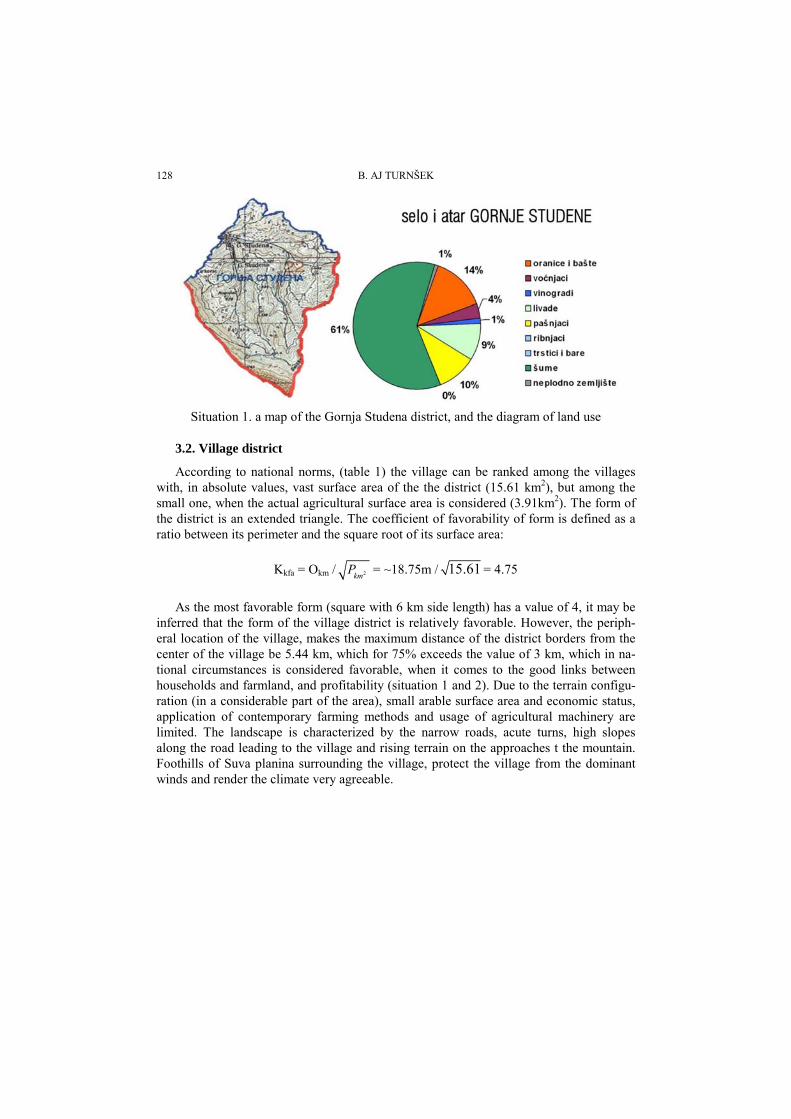
Situation 1. a map of the Gornja Studena district, and the diagram of land use
3.2. Village district
According to national norms, (table 1) the village can be ranked among the villages with, in absolute values, vast surface area of the the district (15.61 km2), but among the small one, when the actual agricultural surface area is considered (3.91km2). The form of the district is an extended triangle. The coefficient of favorability of form is defined as a ratio between its perimeter and the square root of its surface area:
Kkfa = Okm / 2kmP = ~18.75m / 15.61 = 4.75
As the most favorable form (square with 6 km side length) has a value of 4, it may be inferred that the form of the village district is relatively favorable. However, the periph-eral location of the village, makes the maximum distance of the district borders from the center of the village be 5.44 km, which for 75% exceeds the value of 3 km, which in na-tional circumstances is considered favorable, when it comes to the good links between households and farmland, and profitability (situation 1 and 2). Due to the terrain configu-ration (in a considerable part of the area), small arable surface area and economic status, application of contemporary farming methods and usage of agricultural machinery are limited. The landscape is characterized by the narrow roads, acute turns, high slopes along the road leading to the village and rising terrain on the approaches t the mountain. Foothills of Suva planina surrounding the village, protect the village from the dominant winds and render the climate very agreeable.

Gornja Studena Village in the Context of Sustainable Development 129
Table 1. total and reduced surface in the village district according to the manner of usage
Total surface area according to usage (ha) reduced value
Tota
l sur
face
of t
he s
ettle
men
t and
the
dist
rict
ha)
Farn
kabd
abd
veg
etab
le b
eds
(ha)
Orc
hard
s (ha
)
Vin
yard
s (ha
)
mea
dow
s (ha
)
past
ures
(ha)
Fish
pon
ds (h
a)
Mar
shla
nd (
ha)
Woo
ds a
(ha)
Bar
ren
land
(ha)
Ara
ble
land
(1-4
) (ha
)
Agr
icul
tura
l lan
d (1
-7) (
ha)
Tota
l sur
face
are
a (1
-9) (
ha)
Tota
l val
ue o
f lan
d w
ith u
kupn
a po
vrši
na (1
-9) *
X(h
a) b
ez b
onite
ta
ukup
na p
ovrš
ina
(1-9
) *X
(ha)
sa
boni
teto
m
0 1 2 3 4 5 6 7 8 9 10 11 12 13 14
Gor
nja
Stud
ena
1561 184 46 19 124 130 0 0 800 11 373 503 1314 464 391
The village district is rich in woods (61%), pastures and meadows (19%), and to a small extent with farmland and vegetable beds (14%). The households are mostly into animal husbandry and farming, but a large number of them is not participating in agricul-tural activities (30%) and has a mixed orientation (which can be easily concluded from the conducted surveys [2,12]). Dominant farming branches are extensive livestock keep-ing, orchard and vegetable farming, but the production is mostly concentrated on self sustenance, which a very prominent tendency. The majority of livestock is composed of cattle (around 100), sheep (around 300) and various poultry (around 700) [10]. Yield meet the owners’ demand, but only a small part is intended for market. The farmland structure is such that majority of the lots are scattered on several distant locations, with bad access, and practically define the extensive character of production.
Coefficient K1-9, demonstrates the ratio of real and reduced total surface area of the village district: K1-9=12*:13*= 1314:464=2.8 (table 1). If the soil quality is introduced as a criterion, that is profitability, the reduced coefficient K1-9 has a value K1-
9=12*:14*=1314:391=3.4 (as the data for Gornja Studena were not available, the model of the mountainous villages used by Đorđe R Simonović and Milorad B Ribar [1] has been utilized). This means in practice that the agricultural potential of the Gornja Studena village district is three times lower when compared to a similar one in, for instance, the Morava valley.
3.3. Life conditions and infrastructural development
The village possess no school, no community office, no post, health care facility, out-patient clinic, green market, but also no small business services, no warehouses, buying posts, cooperative…the other social, cultural, sport and spiritual facilities are: church, community center built in the 1980’s, but still unfinished, football club and sport buffet. The economic facilities are represented by to general stores, several family crafts work-

B. AJ TURNŠEK 130
shops and seasonal buyers of mushrooms. Village cemetery is in the very village, with in-sufficient space and inappropriately arranged.
The status of infrastructural systems and facilities is unsatisfactory. The whole village has electric power, water supply utilities has 80% of the households. Gornja Studena wa-ter supply network is one of the first sources used for the water supply of Nis, and it was used before the WWII, (since 1930’s). Apart from such a high percentage of households with water supply, only a small number of them have bathrooms and internal toilets, 56%, that is 49%, which indicates the low quality of dwelling. A problem lies in the lack of sewer network, as it is the case with almost all the settlements in the rural city area. A great majority of households has septic tanks, while the local stream is used to let out the sewage, which is a significant and potential hazard, because of the possible pollution. Disposal of solid waste and rubble on the wild disposal sites, most often along the village roads and in the wider village area is also a problem. Road network is very scant, because apart from the main road through the village, which has asphalt coating, all the other roads are the dirt roads, and very narrow at that, only: 2.5-3m. There is a good bus ser-vice, with an appropriate number of departures. The land phone is present in the village, while the tv signal reception is good in one part and bad in the other part of the village due to the terrain configuration.
Situation 2. map of the village and village district of Gornja Studena
(the settlement is developed along the river and road axes)

Gornja Studena Village in the Context of Sustainable Development 131
1.ULAZ U PARCELU2.NADSTREŠNICA ZA SKLADIŠTENJE SENA I DRVA
4.BUNAR5.ŠUPA6.ŠTALA
3.PLEVNJA
10.VOCE
8.STARA STAMBENA ZGRADA9.NOVIJA STAMBENA ZGRADA
7.SALAŠ I AMBAR
1.ULAZ U PARCELU2.STARA STAMBENA ZGRADA3.PLEVNJA
5.SALAŠ6.OBJEKAT U IZGRADNJI
8.STAMBENA ZGRADA7.BAŠTA
4.SKLADIŠTENJE ŽITA I SLAME
3.ŠTALA SA NADSTREŠNICOM2.STOGOVI SENA
4.BAŠTA (POVRCE I CVECE)5.STAMBENA ZGRADA(SPOJ STARE ZGRADE I DOGRAÐENOG DELA)
8.SVINJAC I KOKOŠINJAC7.PCELINJE KOŠNICE6.VOCNJAK (RAZLICITE KULTURE
9.VOCE
1.ULAZ U PARCELU
8
7
6
5
4
3
21
9 8
7
6
54
2 31
1
2
3
4
4
9
1425
2320
71029
80
875
950
106012
85
960
3600
1680
3075
4520
1345
4320
3600
1000
350
1500
1500
500
2320
1000 35
85
12105710
3265
1500
2100
2000
1
5825
2400
6235
2550
1100
1200
4500
1750
3535
9360
7985
12351675
8251400 650
6205
Dvorište 1
Dvorište 2
Dvorište 3
76 8
55
SS
S
1530
3900
500
590
300
1060
350
340
1100
750
1515
900
1.
2.
3.
4.5.
GORNJE STUDENTSKI POTOK
Dvorište 7
1.NOVA KUCA2.STARA KUCA3.LETNJA KUHINJA4.STAJA ZA SVINJE (ŠTALA, ŽIVINARNIK,KOŠ ZA KUKURUZ,NADSTREŠNICA ZA TRAKTOR)5.BAŠTA
S
3.4. Curtilage status
In respect to the similar age structure, size, an professional orientation of the house-holds, as well as the terrain configuration, there are great similarities but also certain dif-ferences as to the organization of yards dwelling conditions. Majority of the households oriented to agricultural production deals with everything – produces a variety of products, mostly for their needs. Consequences of this are evident in the organization of the yard, which must accommodate a large variety of contents, which require a certain space. The photographed lots are typical for this village and present the local approach to yard space organization [2,12].
The yards are mainly located along the main road, while a small number of them are displaced towards the interior of the village district. The limiting factor for a regular ar-rangement of the farming and housing part is a steep gradient, with most of the lots are uphill of the access road. Often, the slope gradient was not used for favorable positioning of the structures. Yard forms are mostly irregular, but can be reduced to predominant trapezoid, elongated rectangular (side ratio more than 1:3), and rectangular (side ratio up

B. AJ TURNŠEK 132
to 1:3) forms. A large number of yards has not been physically and spatially divided into a housing and a farming part. The others have this division, but the zones and structures ac-commodating various contents are not sufficiently spaced. The buildings are most often grouped on the perimeter of the yard, in a line, in the form of the letters «I», «L» and «U», or in two parallel lines (housing and farming buildings one opposite another). There is a small number of yards without any grouping.
13
12
13%
11
10
12
1211
13
4
109
11
88
10
9
7 7
8
9
7
8
2 66
7
5
6
4
5
55
4
4
PP
P+1
P+1
P+1
2
3
3
3
2
2
1
1
1
Dvorište 5
38.6
58.6
23.9 17.8 12.3
60.3
14%
10%
11
6
11
21.3 22.1S
Dvorište 41.STAMBENI DEO2.MEHANIZACIJA3.ĐUBRIVO4.CESMA5.DRVA6.STAJA7.STAJNJAK8.SVINJAC9.ŽIVINARNIK10.SILOROV11.SENO 12.VOCNJAK 13.BAŠTA
Dvorište 61.STAMBENI DEO2.MEHANIZACIJA3.ĐUBRIVO4.DRVA 5.GARAŽA 6.STAJA 7.STAJNJAK 8.ŽIVINARNIK 9.SILOROV 10.VOCNJAK 11.BAŠTA12.POLJSKI WC
Dvorište 6
Dvorište 51. STAMBENI DEO2. MEHANIZACIJA3. ĐUBRIVO4. CESMA5. DRVA6. GARAŽA7. STAJA8.SVINJAC 9.ŽIVINARNIK 10.RADIONICA 11. SENO12.VOCNJAK 13. POLJSKI WC
Fig. 1. Landscape Fig. 2. Village life

Gornja Studena Village in the Context of Sustainable Development 133
Fig. 3. Inclined terrain Fig. 4. Inclined terrain and a new house
Fig. 5. House (built around 1910) Fig. 6. House (built around 1910.)
Fig. 7. Old house (with inadequate addition) Fig. 8. House (built around1920)

B. AJ TURNŠEK 134
Fig. 9. New houses (characteristic examples)
Fig. 10. New houses (characteristic examples)
Fig. 11. Households (characteristic yards)
Gornja Studena Village in the Context of Sustainable Development 135
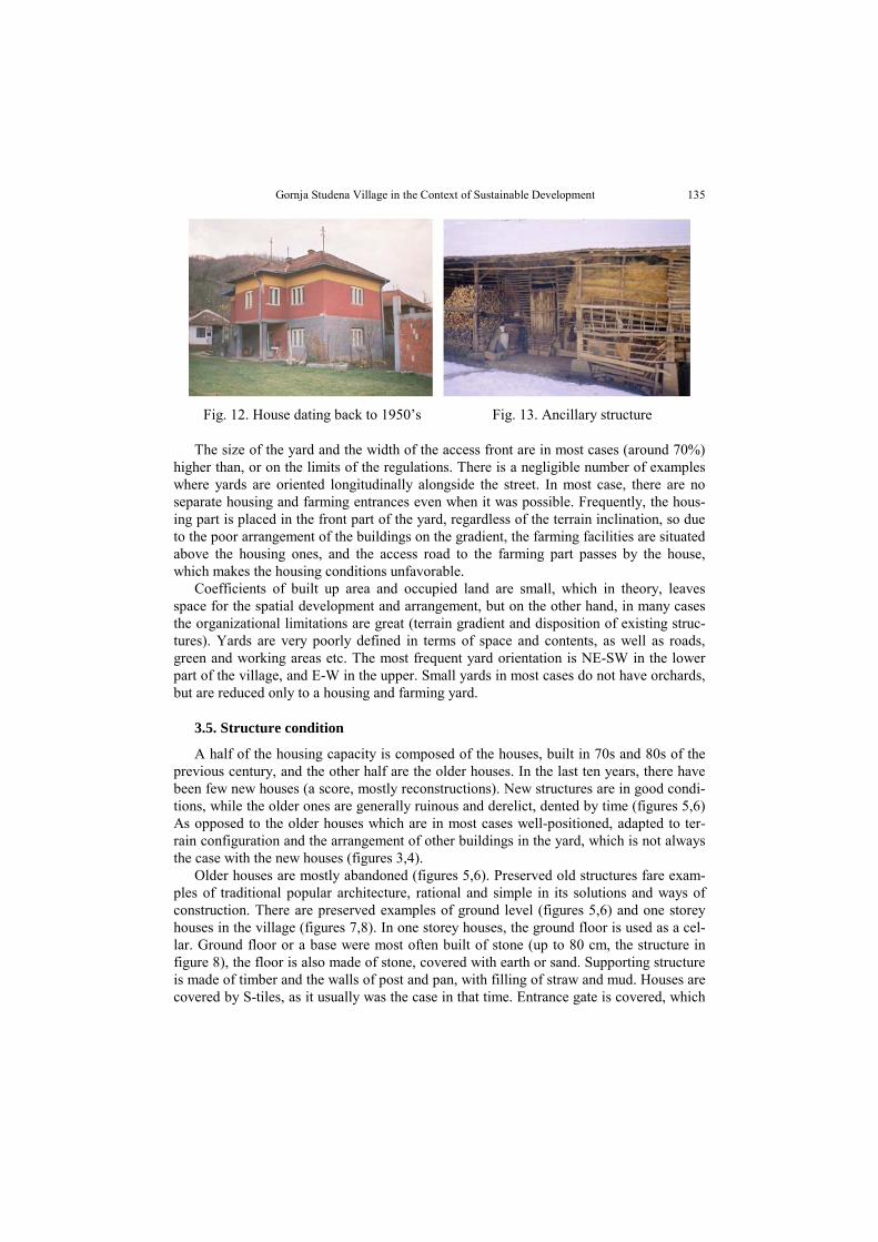
Fig. 12. House dating back to 1950’s Fig. 13. Ancillary structure
The size of the yard and the width of the access front are in most cases (around 70%) higher than, or on the limits of the regulations. There is a negligible number of examples where yards are oriented longitudinally alongside the street. In most case, there are no separate housing and farming entrances even when it was possible. Frequently, the hous-ing part is placed in the front part of the yard, regardless of the terrain inclination, so due to the poor arrangement of the buildings on the gradient, the farming facilities are situated above the housing ones, and the access road to the farming part passes by the house, which makes the housing conditions unfavorable.
Coefficients of built up area and occupied land are small, which in theory, leaves space for the spatial development and arrangement, but on the other hand, in many cases the organizational limitations are great (terrain gradient and disposition of existing struc-tures). Yards are very poorly defined in terms of space and contents, as well as roads, green and working areas etc. The most frequent yard orientation is NE-SW in the lower part of the village, and E-W in the upper. Small yards in most cases do not have orchards, but are reduced only to a housing and farming yard.
3.5. Structure condition
A half of the housing capacity is composed of the houses, built in 70s and 80s of the previous century, and the other half are the older houses. In the last ten years, there have been few new houses (a score, mostly reconstructions). New structures are in good condi-tions, while the older ones are generally ruinous and derelict, dented by time (figures 5,6) As opposed to the older houses which are in most cases well-positioned, adapted to ter-rain configuration and the arrangement of other buildings in the yard, which is not always the case with the new houses (figures 3,4).
Older houses are mostly abandoned (figures 5,6). Preserved old structures fare exam-ples of traditional popular architecture, rational and simple in its solutions and ways of construction. There are preserved examples of ground level (figures 5,6) and one storey houses in the village (figures 7,8). In one storey houses, the ground floor is used as a cel-lar. Ground floor or a base were most often built of stone (up to 80 cm, the structure in figure 8), the floor is also made of stone, covered with earth or sand. Supporting structure is made of timber and the walls of post and pan, with filling of straw and mud. Houses are covered by S-tiles, as it usually was the case in that time. Entrance gate is covered, which

B. AJ TURNŠEK 136
is often met in the village, as a legacy of the past. Reconstructions, adaptation and addi-tions were carried out without professional help, and are frequently non-functional and in an architectonic disharmony.
New houses are big, well equipped, built without plan, (as well as the additions to old houses), which greatly reduced the quality of housing in the yards (figures 5,6). The houses are similar in form, number of storyes and external appearance, without traditional and spatial attributes and recognizable architectonic traits, and are usually high with ground floor, first floor and a loft (figures 4,9,10). Style is mixed, and the porch is sub-stituted by a narrow terrace, whose purpose in terms of usage and aesthetics remains un-clear (figures 4,9,10). Increased building height resulted in a loss of contact with the ground, terrain, which contact was an important property of old, ground floor houses. There several houses in the form of a “Г”, dating back to the 50s of the previous century, which are preserved in their original form (figure 12).
The conditions of farming related structures is not satisfactory, which can be observed in the enclosed figures, which is not surprising considering an increasing number of non-farming households (figures 11,15,16). Even the new ones, are the old structures built with modern materials, very often non-functional and inappropriate, and there are even improvised solutions (figures 17,16). There are older, well preserved buildings built in a traditional way, which are still being used figures 14,15).
Fig. 14. Granary Fig. 15. Stable
Fig. 16. Stable (improvised) Fig. 17. New stable and granary

Gornja Studena Village in the Context of Sustainable Development 137
4. SUSTAINABILITY AND DEVELOPMENTAL POTENTIAL OF HOUSEHOLDS
10% of village households has been analyzed, as random samples, which is a relevant sample (within project and later detailed research and analyses in the framework of the author’s doctoral thesis [2.12]. the choice of the characteristics yards has been made ac-cording to the size, form, orientation, spatial division, functional and content definition, arrangement degree, distribution and condition of the structures. A part of conclusions and photographs, in the form of general conclusions and statements was already laid out in the preceding text, while the concrete conclusions relate to the sustainability of the in-dividual yards and households are presented in the table 2 (basic parameters referring to spatial, organizational and human capacities of households and yards, as well as to the oc-cupation of the residents).
Farming is a dominant category, and the largest part of households is oriented towards cattle breeding, and see their perspective in this, so an organization of farming yards pro-moting this kind of production is hardly surprising. The presence of the small business and crafts shops is small, but a large number of the young is occupationally connected to the city, while the old population is dealing with agriculture. Traditional trades have be-come extinct, or exist only in individual sporadic cases, mostly within families. The ex-ample of flour milling is characteristic – there are watermills in area, as well as in other villages in the Jelasnica valley. In the 60s, flour milling as a trade almost ceases to exist, and the buildings fall into disrepair, so only the stories and several dilapidated buildings stand witness of the trade.
Table 2. presentation of condition and sustainability of analyzed yards and households
yard 1 2 3 4 5 6 7 8 9 10 11 12 Age structure ■ ▲ Θ ☼ ☼ ☼ ▲ ▲ ▲ ☼ ☼ ☼ Sustainability of the yard in function of development
☼ ☼ ▲ ▲ ▲ ▲ ▲ ▲ ▲ ▲ ☼ ☼
Gor
nja
Stud
ena
Sustainability of household ©▲ ©□☼ ©□■ □☼ □☼ □☼ ©□▲ ☼ ▲ ☼ ☼ □☼
☼ Meets the conditions - satisfactory ▲ Bordering satisfactory conditions (±10%) ■ Does not meet conditions – unsatisfactory □ Limited spatial and organizational capacities of yards le
gend
a
©, Θ Limited human resources, work force problems and youth dealing with agriculture
It is not possible to realize an increased production in a large part of the village, pri-marily due to the spatial and organizational problems in the yards, that is the arrangement of the zones and disposition of the existing structures as well as the terrain configuration. Some significant improvement or increase of production could be displaced on the pe-riphery of the village, or more likely into the fields (pastures). Construction of new buildings behind the existing yards is not likely because of steep gradient. This is par-ticularly important because of the expected changes in the economic structure of the vil-

B. AJ TURNŠEK 138
lage, where character of the household and contents of the yards will change in respect to the specifics of the owners occupation.
From the detailed surveys and analyses which ensued [2,12] and confirmed the initial assumptions, it is evident that the village is in significant economic and demographic dis-tress, and the it is bordering the limit of population sustainability. The great majority of households is conditionally sustainable (table 2), provided the considerable organiza-tional, spatial and infrastructural limitations of the yard are overcome, that is, the lack of work force. A lot of households is comprised by the people older than 50 years (which can be seen from the table 2), and considering that a majority of the young (professionally connected to the city) have already formed households in the city or suburban area (which is more frequent), it is unlikely that they will return.
5. INSTEAD OF CONCLUSION
Gornja Studena village possess an extraordinary potential in woods and pastures, so the development perspective in agriculture (livestock keeping, in the pastures), cultivating and gathering of medicinal herbs and forest fruit (bear’s garlic, mushrooms), organic food, picnic, sport (winter sports, ski trek) and rural tourism (in the vicinity of Bojanine vode).
Redefinition of the production, planned production and planned activation of the natu-ral resources, on the basis of the sustainability principles, would increase the quality and widen the range of potentials to work and would create new jobs. Most likely the natural resources would be renewed, primarily cattle breeding (on the pastures) and organic food production. These changes should be followed by small businesses and services, and an affirmation of ethno-business, as well as revitalization of old trades (flour milling). As a sizeable part of the households is dealing with non-agricultural occupations, there is po-tential. In this case, the yards should be transformed, and become more specialized, and the production should exceed the domestic needs. If a systemic and planned approach is applied, cultivation and gathering of medicinal herbs and forest fruit, can become an im-portant factor of the sustainable village development and environment protection, of pro-motion and affirmation of the area.
Change of production orientation and structure and adapting to the modern conditions, which is realistic to expect, would significantly influence the need of structural and func-tional reorganization re-organization and reconstruction of certain parts of the yards. This does not mean a total abolition of traditional architectonic motifs and urban matrix, but their transformation and adaptation to a new situation, as well as functional transforma-tion which will point out the traditional values. However, as the spatial and organizational potentials of the yards are limited, despite their size, the majority would have to undergo significant reconstructions to create space for new contents and structures: in the cases of switching to gathering and processing of medicinal herbs and forest fruits (warehouses, drying facilities), or of switching to tourism (garage, adaptation of old and new houses, possible reconstruction and addition) and ancillary – service activities (service providing facilities, warehouse space etc.) It is necessary to firs revitalize the old structures and a part of the existing housing capacities, and to render it functional, to accommodate guests or expand the tourist contents. The consequence would be displacement of the part of fa-

Gornja Studena Village in the Context of Sustainable Development 139
cilities onto another part of the estate (production facilities, stables). Large buildings should be located in the peripheral parts of the village.
Essential problems are: rural character, unused and maladjusted structure of produc-tion to the existing resources, weak economic status and infrastructural and institutional equipment. As opposed to some other settlements in this region, the dominant factor is not the depopulation of the area, that is migration processes, though they are not inconsider-able either, but ageing of the village because of the orientation of the young population to the city.
The natural resources are not inconsiderable, but the village must overcome the main problem, and that is migration of the young population and ageing of population. If it keeps the human resources (almost 20% of the youth), with appropriate investment in the infrastructure, sustainable projects and accompanying small business, the village has a perspective and a future in farming and tourism. In that case, the village will keep its agri-cultural character, but with more elements of tourism and small business, and a larger number of mixed-oriented households. Otherwise, it will remain marginal with unused potentials.
REFERENCES 1. Đorđe R Simonović, Milorad B Ribar.: Uređenje seoskih teritorija i naselja, Univerzitet u Beogradu,
Arhitektonski fakultet, Beograd, 1993.god. 2. Branko AJ Turnšek.: Transformacija seoskog domaćinstva u selima na području grada Niša u kontekstu
održivog razvoja, doktorska disertacija, 897.str, 2007. godina, Niš 3. Branko AJ Turnšek, Aleksandar Đ Keković.: Selo na putu u Evropu, naučni skup “Selo u novim
razvojnim uslovima ’02 “, Udruženje Urbanista Srbije, str. 57-63, 2002.godina, Mataruška Banja 4. Mirjana Anđelković, Branko AJ Turnšek, Sonja Krasić.: Mogući pravci razvoja privrede sela Niškog
regiona, naučni skup “Selo u novim razvojnim uslovima ’02 “, Udruženje Urbanista Srbije 2002.godina, str. 441-449, Mataruška Banja
5. Mirjana Anđelković, Hranislav Anđelković.: Pravci održivog razvoja sela na administrativnom području grada Niša, naučni skup “Selo u novim razvojnim uslovima ’02“, Udruženje Urbanista Srbije 2002.godina, str.178-185, Mataruška Banja
6. Branko AJ Turnšek.: Održivi razvoj sela na administrativnom području grada Niša, Savetovanje: Selo u Novim razvojnim uslovima, 2003.godina, str. 330-345, Bač
7. Aleksandar R. Krstić: Ponišavlje u XV veku, Beograd, jul 2001.godine 8. Pravilnik o opštim pravilima urbanističke regulacije i parcelacije, Službeni glasnik RS 1998. godina 9. Zakon o prostornom planu Republike Srbije, "Službeni glasnik RS", br. 13/96 1996.god.
10. Statistički godišnjak grada Niša 2001, Republika Srbija, gradska uprava grad Niš, Sekretarijat za razvoj i informacioni sistem, Niš, decembar 2002.godine
11. Enciklopedija Niša-priroda,prostor,stanovništvo,Niš,Gradina,izdanje 1995.godine 12. Pravci održivog razvoja sela, na administrativnom području grada Niša, naučno-istraživački projekat,
Građevinsko-Arhitektonski fakulteta u Nišu, finansiran od strane Ministarstvo za nauku, tehnologije i razvoj i Skupštine Opštine Niš. Nosilac projekta: dr Mirjana Anđelković, red. prof. Građevinsko-Arhitektonskog fakulteta u Nišu, Niš 2004.godina, Univerzitet u Nišu, 245str. .

B. AJ TURNŠEK 140
SELO GORNJA STUDENA U KONTEKSTU ODRŽIVOG RAZVOJA
Branko AJ Turnšek
U radu je analizirano sadašnje stanje elemenata održivosti na nivou sela, a potom i na relevantnom reprezentativnom uzorku domaćinstava, preko unapred definisanih parametara. Po definiciji ovako sagledani prirodni, ekonomski, ljudski i prostorni resursi, opisuju sadašnji trenutak, uzroke i posledice, ali i definišu stepen održivosti, kapacitete i pravce mogućeg razvoja. Dobijeni rezulatati i izvedeni zaključci su poslužili kao osnova za sagledavanje daljeg razvoja i transformacije sela, domaćinstava, odnosno dvorišta kao prostornog okvira domaćinstva i mesta na kome se ovi procesi odvijaju.
Gornja Studena pripada grupi spontano nastalih, razređeno zbijenih brdskih sela. Formirano u gornjem delu Jelašničke doline, na obroncima Suve planine, pod Mosorom, duž puta koji vodi od Niša ka Bojaninim Vodama, naselje se razvilo istočno i zapadno od puta i Studeničkog potoka, koji protiče sredinom sela, paralelno sa putem.
Priroda je bila i izdašna i škrta, kako to uvek biva, uzimajući na jednoj daje na drugoj. Bogati kompleksi šuma i pašnjaka, prirodne pogodnosti i uslovi za bavljenje stočarstvom, prijatna klima, kao i druge prirodne i ambijentalne vrednosti, blizina ski centra i turističke destinacije Bojanine vode, nisu pomogli razvoju sela. Locirano je na obodu, među najudaljenijim od grada, povučeno u odnosu na glavne putne pravce (mada nije uvek bilo tako), sa slabom infrastrukturnom i komunalnom opremljenošću, sa velikim brojem starijih žitelja, slabe ekonomske moći, nevelikih zemljišnih resursa i nepovoljne konfiguracije terena za intenzivan razvoj poljoprivrede. Demografski je znatno osiromašeno, a preostali mladi u velikoj meri profesionalno orijentisani na grad.