government of gujarat water...gujarat –a water scarce state one of the worst water scarce states...
TRANSCRIPT

Government of Gujarat
Water Supply System Based on Narmada Dam
A LIFE LINE OF GUJARAT
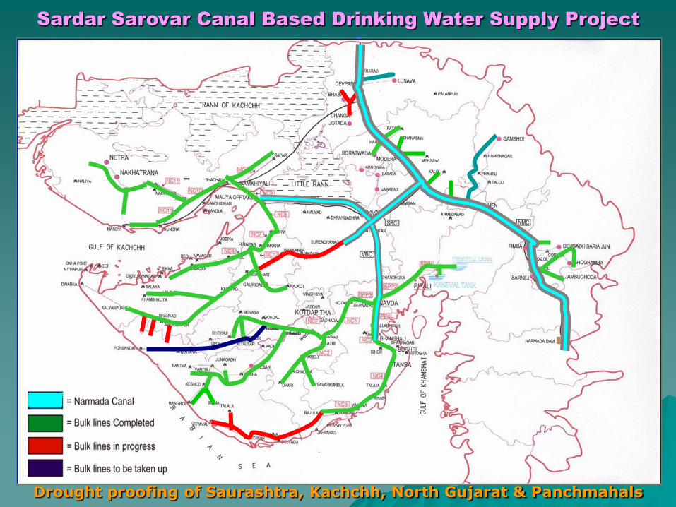
Sardar Sarovar Canal Based Drinking Water Supply Project
Drought proofing of Saurashtra, Kachchh, North Gujarat & Panchmahals

Gujarat State Profile
No. of Districts : 26 No. of Talukas : 226 No. of Villages : 18066 No. of Towns : 242 Total Population (2001) : 506.71 Lacs Rural Population : 317.41 Lacs Urban Population : 189.30 Lacs
Comprised of four distinct Regions-
Saurashtra - Surendranagar, Rajkot, Jamnagar,Junagadh, Porbandar, Amreli, Bhavnagar
Kachchh - Kachchh
North Gujarat - Ahmedabad, Gandhinagar, Mehsana,Patan, Banaskantha, Sabarkantha
Central & - Kheda, Anand, Vadodara, Panchmahal,South Guijarat- Dahod, Narmada, Bharuch, Surat, Tapi,
Dang, Navsari, Valsad

Gujarat – A Water Scarce State
One of the worst water scarce states in India with high variation in rainfall.
The State was hit by three consecutive droughts from 1985-88 and again from1999-2002. The year 1999 was one of the worst drought year of the century.
The State has only three perennial river namely Mahi, Narmada and Tapi inCentral & South Gujarat
Saurashtra, Kachchh, North Gujarat and Panchmahal areas of Gujarat Stateare facing acute water scarcity throughout the year as in these areas therainfall is scanty and there is no perennial river.
The underground sources are not adequate to cater the drinking water demandto overcome the drinking water supply problem.
Ground water table is depleting @ 3 to 5 Mtrs. depth every year.
74% of the State area is unsuitable for ground water withdrawal due to rockyterrain and coastal region.
In most of the districts ground water contains excessive fluorides, nitrate &salinity.
Most of the Saurashtra region comprises of hard rock where ground water isavailable from cracks and crevices.
Ground water on the coast is saline with salinity ingress into the land areas.

Fresh water availability
Uneven water availability in the State
Cum/Capita/annum
– India 2,000
– Gujarat 1,137
– South &
Central Gujarat 1,932
– North Gujarat 342
– Saurashtra 734
– Kutch 875
Except South Gujarat, paucity of water in rest of the State
Drinking water scarcity felt in almost 2/3rd part of the State

Problems of Drinking Water
• Long coastline (1600 Kms.) & Gulf – Salinity
ingress
• Hills and Low recharge
• Excessive exploitation of ground water
• Recurrent Droughts
• Re-emergence of villages as not covered or partially covered
Seasonal Scarcity
Salinity
Nitrate
Fluoride
As per Rajiv Gandhi National Drinking Water Mission Survey 2003-04
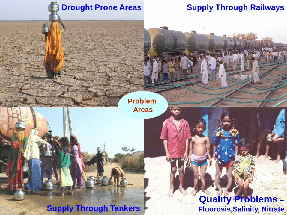
Drought Prone Areas Supply Through Railways
Supply Through TankersQuality Problems –Fluorosis,Salinity, Nitrate
Problem
Areas

Planning Strategy to solve drinking water problem
Inter-basin transfer of water from water surplus areato water scarce area.
It is planned to supply Narmada Water to 9633 villagesand 131 towns of Saurashtra, Kachchh, North Gujaratand Panchmahal areas of Gujarat State from SardarSarovar Narmada Canal based drinking water supplyproject.
Drinking water will be supplied to villages/towns ofCentral & South Gujarat from Irrigation Reservoir-Canalbased water supply projects.
Drinking water will be provided to villages/towns ofEastern Tribal Belt through Hand pumps, Mini pipedwater supply schemes and Recharging Structures
Year 1999 onwards

Narmada Water Allocation
Water Allocation as per Narmada Tribunal Award (1978)-
State Quantity (MAF)
Madhya Pradesh 18.25
Gujarat 9.00
Rajasthan 0.50
Maharashtra 0.25
Total 28.00

Narmada – A Permanent Solution for drinking water
The Narmada Tribunal hasallocated 1.06 MAF (3571MLD) water for domestic andindustrial use in Gujarat(0.86 MAF – 2900 MLD fordrinking and 0.20 MAF – 671MLD for industrial purpose).
The Government of Gujarathas conceived andformulated a Master Plan forsupply of drinking water to9633 villages and 131 urbancenters of 17 districts fromNarmada Canals.
53 %
56 %
8,4339,633
Covered
Not Covered
47%

Project Area covered under Narmada Master Plan
No. of Districts : 17 No. of Talukas : 142 No. of Villages : 9633 No. of Towns : 131 Total Population (2001) : 243.36 Lacs Rural Population : 170.48 Lacs Urban Population : 72.88 Lacs
Districts covered under Narmada Canal Based Water Supply Project-
Fully covered-
Saurashtra - Surendranagar, Rajkot, Jamnagar, Junagadh,Porbandar, Amreli, Bhavnagar
Kachchh - Kachchh
North Gujarat - Ahmedabad, Gandhinagar
Partially covered-
North Gujarat - Mehsana, Patan, Banaskantha, Sabarkantha
Central Guijarat - Kheda, Panchmahal, Narmada

Implementing Organizations
Sardar Sarovar Narmada Nigam Limited (SSNNL)-
Construction of Dam and Canal Network for Irrigation and WaterSupply purposes
Irrigation Department (Water Resources)-
Implementation of Irrigation Pipelines from Narmada Canals,Development of Barrages, Ponds, Surface Reservoirs & Check Dams.
Gujarat Water Infrastructure Limited (GWIL)-
Implementation and O&M of Bulk Water Transmission Pipelines fromNarmada Canals
Gujarat Water Supply & Sewerage Board (GWSSB)-
Implementation and O&M of Distribution Group Water SupplyProjects from Bulk Water Transmission Pipelines, Narmada Canalsand Irrigation Infrastructure (Irrigation Pipelines, Ponds & Dams tobe filled with Narmada water) to Outdoor of the Local Body Premises.
Water and Sanitation Management Organization (WASMO)-
Development of In-village water supply facilities through VillagePanchayats.

Water Supply System Based on Narmada Dam
• Sardar Sarovar Dam- Located nearvillage Navagam (Tal- TilakwadaDist- Narmada)
• Narmada Main Canal- From Dam toSouth of Rajasthan
• Saurashtra Branch Canal- FromNarmada Main Canal near Kadi inMehsana District to DholidhajaReservoir in Surendranagar District
Maliya Branch Canal- From Saurashtra Branch Canal near Dhanki in
Surendranagar District to village Khirai Tal- Maliya Dist - Rajkot
Vallabhipur Branch Canal- From Saurashtra Branch Canal near Dhankiin Surendranagar District to village Meghvadar Tal- Vallabhipur Dist- Bhavnagar
Vehlal Branch Canal, Dholka Branch Canal, Zinzuwada Branch Canaland Mahemdabad Branch Canal.
Canal Network-

Lift Stations in Saurashtra Branch Canal
• Dholidhaja Reservoir is filled withNarmada Water on 29.11.2009
• Lift Stations – 5 Nos.
Between Dhanki & Surendranagar
• Nos. of Pump - 26 Nos. x 20 Cusecs- 22 Nos. x 5 Cusecs
• Total Lift - 71 Meters
• Location- Surendranagar District
Vill. Lilapur Tal. Lakhtar - 11 mt. lift
Lakhtar - 16 mt. lift
Vill. Bala Tal. Wadhwan - 15 mt. lift
Vill. Rajpar Tal. Wadhwan - 12 mt. lift
Vill. Dudhrej Tal. Wadhwan - 17 mt. lift
• Total Cost -Rs.535.00 Crore
P.S. at Lilapur - One ofthe biggest PumpingStations in the World
Water Supply System Based on Narmada Dam

Water Supply System Based on Narmada Dam
Water Supply Network-
• Bulk Water Transmission Pipeline Off-takes from Canals- 7 Off-takes
3 Off-takes from Narmada Main Canal1 Off-take from Saurashtra Branch Canal2 Off-takes from Vallabhipur Branch Canal1 Off-take from Maliya Branch Canal
• Distribution Group Project Off-takes from Canals- 16 Off-takes
7 Off-takes from Narmada Main Canal2 Off-takes from Saurashtra Branch Canal2 Off-takes from Vallabhipur Branch Canal1 Off-take from Maliya Branch Canal1 Off-take from Vehlal Branch Canal 1 Off-take from Dholka Branch Canal1 Off-take from Zinzuwada Branch Canal1 Off-take from Mahemdabad Branch Canal
• Distribution Group Project Off-takes from Irrigation Pipelines,Ponds & Dams to be filled with Narmada water - 16 Off-takes

Main Project Highlights
Year 2011 2021 2031
Rural 204.57 238.68 272.76
Urban 87.46 102.03 116.61
Total 292.03 340.71 389.37
Planned Supply (MLD)
2917.42 3641.78 4309.59
• 2700 Kms. of Trunk Mains.
• 9633 villages and 131 towns (17 districts)
• Water reservation – 2900 MLD for drinking671 MLD for industrial use
• Beneficiary Population (In Lacs) -

Planning for Bulk Water Transmission Mains
• The water is to be drawn from 7 off-take points for Bulk Water Transmission& 16 off-take points for Distribution from Narmada Canals and 16 off-take points forDistribution from Irrigation Infrastructure - Irrigation Pipelines, Ponds & Dams to befilled with Narmada Water covering the project area.
S. No.
Off-take Point
Transmission SectionLength (Kms.)
Population to be
covered (Lacs)
Water Supply in
Mld (2021)
1 A Surendranagar (Dholidhaja)– Dwarka 406 30.64 328.39
2 BVallabhipur (Meghvadar) – Veraval –
incl. 146 Kms. Parallel Pipeline up toRajula (Kadiyali)
513 47.08 455.10
3C Maliya (Khirai) – Jamnagar 223 19.99 370.76
K Maliya (Khirai) – Netra 393 21.83 199.48
4 DNavda – Porbander - incl. 275 Kms.
Parallel Pipeline up to Jetpur1060 76.51 640.25
5 G Nabhoi – Gandhinagar 26 5.88 273.00
6 M Modhera – Mehsana 22 9.78 96.44
7 P Sarnej – Ghoghamba 57 5.37 71.92
* Narmada Canals & Irrigation Infrastructure - 123.63 1206.44
Total 2700 340.71 3641.78

Planning for Distribution Group Projects
• The water is to be drawn from 39 off-take points taken from Bulk Water TransmissionMains, Narmada Canals & Irrigation Infrastructure and to be distributed up toOutdoor of the Local Body Premises.
S. No.
Section Area Covered
Villages
to be covered
Towns
to be covered
1 A Covers part of Rajkot and Jamnagar Districts 698 16
2 BCovers part of Bhavnagar, Amreli and JunagadhDistricts
1176 16
3C Covers part of Rajkot and Jamnagar Districts 423 7
K Covers Kachchh District 886 8
4 DCovers part of Ahmedabad, Bhavnagar, Amreli,Rajkot, Junagadh and Porbander Districts
1817 25
5 GCovers GUDA villages & Gandhinagar City inGandhinagar District
31 1
6 MCovers Mehsana, Becharaji and Chanasma Talukasin Mehsana and Patan Districts
225 3
7 PCovers Halol, Jambughoda and Ghoghamba talukasin Panchmahal District
240 1
* Narmada Canals & Irrigation Infrastructure basedDistribution Group Projects cover Surendranagar District,Central and North Gujarat
4137 54
Total 9633 131

Project Cost
S. No.
Project AreaBulk Water
Transmission Mains
Distribution Group Projects
Total Cost
1 Section - A 572.44 266.58 839.02
2 Section - B 1070.98 583.61 1654.59
3Section - C 486.66 137.86 624.52
Section - K 393.02 280.84 673.86
4 Section – D 1154.20 780.85 1935.05
5 Section - G 46.18 20.56 66.74
6 Section - M 23.76 120.59 144.35
7 Section - P 37.44 90.80 128.24
* Narmada Canals & Irrigation InfrastructureBased Distribution Group Projects
2186.78 2186.78
Total 3784.68 4468.47 8253.15
(Rs. In Crores) Capital Cost -
Annual O &M Cost – Rs. 412.66 Crore
Cost Per Capita - Rs. 2422.34
Cost Per Kilo Liter – Rs. 3.10

Present Status of Implementation
S. No.
Project Area
Bulk Water Transmission
Mains Laid (Kms.)
Distribution Group Projects
Villages connected
Towns connected
1 Section - A 259 287 3
2 Section - B 228 670 13
3Section - C 223 423 7
Section - K 393 706 8
4 Section – D 705 1354 23
5 Section - G 26 31 1
6 Section - M 22 225 3
7 Section - P 47 0 0
* Narmada Canals & Irrigation InfrastructureBased Distribution Group Projects
2378 44
Total 1903 6074 102
The Government of Gujarat is implementing the Project since year 1999-2000
Project Area covered -
• Works in progress 296 2312 23
• Works under planning 501 1247 6

Infrastructure Creation
Sardar Sarovar Dam Intake Structure
Head Works Pumping Machinery

Infrastructure Creation
Filtration Plant Large Dia. PipesSump & ESR
Pipeline Village Storage Stand Post

Major Works
Works Executed -
Pipelines … 24880 Kms.
ESRs … 417 Nos.
Sumps … 2637 Nos.
Water Treatment Plants … 69 Nos.
Works in Progress -
Pipelines … 4528 Kms.
ESRs … 189 Nos.
Sumps … 814 Nos.
Water Treatment Plants … 36 Nos.

Expenditure incurred
S. No.
Project AreaBulk Water
Transmission Mains
Distribution Group Projects
Total Expenditure
1 Section - A 265.59 177.66 443.25
2 Section - B 292.72 314.38 607.10
3Section - C 468.16 129.64 597.80
Section - K 393.02 225.81 618.83
4 Section – D 643.20 659.31 1302.51
5 Section - G 46.18 20.56 66.74
6 Section - M 23.76 120.59 144.35
7 Section - P 30.73 52.44 83.17
* Narmada Canals & Irrigation InfrastructureBased Distribution Group Projects
1480.60 1480.60
Total 2163.36 3180.99 5344.35
(Rs. In Crores)

District-wise Coverage of Villages
S. No.
DistrictTotal No. of Villages in
District
Villages incl. under Narmada
Villages
connected for water supply
% Villages Covered
1 Amreli 615 615 446 73
2 Bhavnagar 790 790 790 100
3 Junagadh 923 923 360 39
4 Porbander 182 182 11 6
5 Rajkot 844 844 541 64
6 Jamnagar 698 698 418 60
7 Kachchh 886 886 706 80
8 Surendranagar 650 650 426 66
9 Ahmedabad 546 546 508 93
10 Gandhinagar 291 291 291 100
11 Mehsana 593 464 464 100
12 Patan 517 421 323 77
13 Banaskantha 1244 816 454 56
14 Sabarkantha 1372 956 271 28
15 Panchmahal 1201 408 0 0
16 Narmada 552 78 0 0
17 Kheda 612 65 65 100
Total 12516 9633 6074 63

District-wise Coverage of Towns
S. No.
DistrictTotal No. of
Towns in District
Towns
incl. under Narmada
Towns
connected for water supply
% Towns Covered
1 Amreli 8 8 8 100
2 Bhavnagar 13 13 13 100
3 Junagadh 12 12 9 75
4 Porbander 5 5 0 0
5 Rajkot 10 10 6 60
6 Jamnagar 16 16 9 56
7 Kachchh 8 8 8 100
8 Surendranagar 7 7 6 86
9 Ahmedabad 25 25 21 84
10 Gandhinagar 10 4 4 100
11 Mehsana 8 7 7 100
12 Patan 5 5 5 100
13 Banaskantha 6 2 2 100
14 Sabarkantha 8 6 3 50
15 Panchmahal 6 3 1 33
16 Narmada 3 0 0 0
17 Kheda 8 0 0 0
Total 158 131 102 78

Coverage under Narmada Network

Year-wise Coverage
(Year 1999-2000 to 2009-10)
YearNos. of Project started
Cost (Rs. In crore)
Nos. of Project
completed
Bulk Pipelines laid-Kms
Villages covered
Towns covered
Exp. (Rs. in crore)
1999-2000 7 589.90Bulk Water Pipeline & Distribution Group Projectsstarted
2000-2001 29 688.29 9 560 359 22 916.80
2001-2002 7 584.27 11 329 113 1 298.02
2002-2003 19 479.39 17 190 410 3 626.43
2003-2004 22 1085.56 19 293 363 8 496.93
2004-2005 25 1054.84 6 20 607 16 499.43
2005-2006 1 37.44 7 22 591 7 745.91
2006-2007 7 318.37 7 368 1121 8 608.35
2007-2008 2 126.34 9 90 1350 14 362.32
2008-2009 6 610.17 17 24 550 14 457.04
2009-2010 (Till 01.10)
13 1355.99 0 7 610 9 333.12
Total 138 6930.56 102 1903 6074 102 5344.35

Supply of Narmada Water
(Year 2000-01 onwards)
S. No.
Location MLD
1 Vallabhipur Branch Canal (Navda) 339.19
2 Maliya Branch Canal (Khirai) 349.98
3 Narmada Main Canal (Nabhoi) 126.70
4 Narmada Main Canal (Modhera) 68.63
5 Narmada Main Canal (Sarnej) 0
*Narmada Canals and Irrigation infrastructure
367.32
Total 1251.82
Supply of Water -
Beneficiary Population - 206.18 Lacs
Annual O &M Cost – Rs. 267.22 Crore
Cost Per Capita - Rs. 2592.08
Cost Per Kilo Liter – Rs. 5.85

Way Ahead…
75% population to be covered with surface water(more than 60% by Narmada Plan)
In-village distribution by Pani Samitis in all villages
Tap connectivity to 75% households
Total coast line villages to be covered by 2010
Use of modern technology in control and monitoring
Use of non-conventional energy
Possibility of PPP models (Public Private Partnership)

Thank You