government of india - world bank · pdf filegovernment of india ... irc indian roads congress...
TRANSCRIPT

E893Volume 2
GOVERNMENT OF INDIAMinistry of Rural Development
Environmental Codes of Practice
Study on Environmental and Social Aspects of
PRADHAN MANTRI GRAM SADAK YOJANA
February 2004
LEA Associates South Asia Pvt. Ltd, New Delhi
Pub
lic D
iscl
osur
e A
utho
rized
Pub
lic D
iscl
osur
e A
utho
rized
Pub
lic D
iscl
osur
e A
utho
rized
Pub
lic D
iscl
osur
e A
utho
rized
Pub
lic D
iscl
osur
e A
utho
rized
Pub
lic D
iscl
osur
e A
utho
rized
Pub
lic D
iscl
osur
e A
utho
rized
Pub
lic D
iscl
osur
e A
utho
rized

Table of Contents
TABLE OF CONTENTS..I
LIST OF ANNEXURES..I1
ABBREVIATIONS..II1
INTRODUCTION ....................................................... IV
ECOP-1.0 PROJECT PLANNING & DESIGN .1-1
ECOP-2.0 SITE PREPARATION .2-1
ECOP-3.0 CONSTRUCTION CAMPS .3-1
ECOP-4.0 ALTERNATE MATERIALS FOR CONSTRUCTION .4-1
ECOP-5.0 BORROW AREAS .5-1
ECOP-6.0 TOPSOIL SALVAGE, STORAGE AND REPLACEMENT .6-1
ECOP-7.0 QUARRY MANAGEMENT .7-1
ECOP-8.0 WATER FOR CONSTRUCTION .8-1
ECOP-9.0 SLOPE STABILITY AND EROSION CONTROL .9-1
ECOP-10.0 WASTE MANAGEMENT .. 10-1
ECOP- 1 1.0 WATER BODIES.. 11-
ECOP-12.0 DRANAGE .. 12-1
ECOP-13.0 CONSTRUCTION PLANTS & EQUIPMENT MANAGEMENT .13-1
ECOP-14.0 PUBLIC AND WORKER'S HEALTH AND SAFETY . .14-1
ECOP-15.0 CULTURAL PROPERTIES .. 15-1
ECOP- 16.0 TREE PLANTATION .. 16-1
ECOP-17.0 MANAGING INDUCED DEVELOPMENT . .17-1
ECOP-18.0 ENVIRONMENTAL AUDIT .. 18-1
ECOP-19.0 NATURAL HABITATS ...................................................... 19-1
ECOP-20.0 CONSULTATIONS FOR ENVIRONMENTAL ASPECTS .................................. 20-1
REFERENCES ....................................................... V

List of Annexures
ANNEXURE 1-1: SCREENING OF SUB-PROJECTS
ANNEXURE 2-1: MOU BETWEEN PIU AND REVENUE DEPARTMENT
ANNEXURE 3-1: SAMPLE LAYOUT OF CONSTRUCTION CAMP
ANNEXURE 4-1: MOU FOR PROCURING QUARRY OVERBURDEN
ANNEXURE 5-1: CERTIFICATE FOR COMPLETION OF RECLAMATION
ANNEXURE 8-1: LETTER OF CONSENT FOR USAGE OF WATER FOR CONSTRUCTION
ANNEXURE 10-1: NO OBJECTION CERTIFICATE FOR TEMPORARY USAGE OF LAND
ANNEXURE 11-1: DRAWING AND BOQ FOR WATER BODY PROTECTION
ANNEXURE 15-1: DRAWING AND BOQ FOR RELOCATION OF CULTURAL PROPERTY
ANNEXURE 16-1: MOU BETWEEN PRI, PIU AND FOREST DEPARTMENT
ANNEXURE 20-1: INFORMATION BROCHURE
ANNEXURE 20-2: METHODOLOGY FOR TRANSECT WALK
ANNEXURE 20-3: FORMAT FOR RECORDING CONSULTATION

Abbreviations
AAV Aggregate Abrasion ValueBoQ Bill of Quantities
CD Structures Cross Drainage Structures
CPCB Central Pollution Control BoardDPR Detailed Project Report
ECoP Environmental Code of PracticeGP Gram Panchayat
GS Gram Sabha
GSB Granular Sub- Grade
HFL High Flood Level
IRC Indian Roads Congress
IS Indian Standards
MoEF Ministry of Environment and ForestMoRD The Ministry of Rural DevelopmentMoRT&H Ministry of Road Transport and HighwaysMoU Memorandum of Understanding
NOC No-Objection Certificate
NQM National Quality Monitor
O & M Operation and MaintenanceODR Other District Roads
OM Operations Manual
PIU Programme Implementation UnitsPMGSY Pradhan Mantri Gram Sadak YojanaPRIs Panchayat Raj Institutions
PSV Polished Stone Value
PUC Pollution Under ControlPWD Public Works Department
RoW Right of Way
S W Plains South West Plains
SP Special Publications
SPCB State Pollution Control BoardWBM Water Bound Macadam

Introduction
Rural Connectivity and growth are linked -
intrinsically, be it in the area of Trade, Employment, * Achieving all-weather road access io e%eryEducation or Healthcare. Rural road connectivity is a village,habitation with a population grealer thankey component of rural development in securing 1000 by 2003; andpoverty alleviation by providing easy access to * Providing all-weather road access. to allmarketing centers for the agricultural produce at villages/habitations of greater than 500 people [250
in case of hill states (North-East, Sikkim, Himachallower transportation cost resulting in higher price Pradesh, Jammu & Kashmir and Uttaranchal) andrealisation thereby increasing rural income. The the desert areas (as identified in the Desertroads further promote access to education, Development Programme)] by the end of the Tenthhealthcare, increased employment opportunities, Five Year Plan, i.e., 2007.improve economic activities and generally result in higher standard of living. Against the abovebackground of inadequate rural road connectivity, the Prime Minister announced in 2000 the PradhanMantri Gram Sadak Yojana (PMGSY), a program to address this backlog of connecting the 3,30,000unconnected habitations.
The Ministry of Rural Development (MoRD) administers the program as a centrally sponsored scheme inall the States and six Union Territories. The MoRD has identified executing agencies in each of thestates. These agencies have worked out mechanisms for implementation through setting up ofProgramme Implementation Units (PIU) in each of the districts.
1. Need for Environmental Codes of PracticeThe Indian Roads Congress (IRC) publication(IRC: SP: 20-2002) Rural Roads Manual(RRM), provides guidance on various aspects ofrural road development, with the specific To form a field guide/manual to the planners, fieldrural road development, with the specific enieradcotcost:requirements of PMGSY. Further to this, to engineers and contractors to:. Identify the project activities that can have potentialbring about clarity on various aspects of the environmental impacts and to provide mitigationprogramme, leading to its timely and successful measuresimplementation, an Operations Manual (OM) in * Demonstrate the road design and construction practices,respect of PMGSY roads has been prepared. that are cost-effective and address environmental impactsRural road improvements such as the PMGSY * Illustrate the recommended practces to address thehave the potential to bring in substantial environmental concerns during project planning,economic and social benefits to the implementation and operationcommunities. At the same time, these projects * Define the role of involvement of the rural communitiesmay also lead to adverse social and at different stages of the project, and,
environmea i* Achieve the PMGSY objectives of rural connectivityI, through roads planned and constructed to blend with theerosion etc, thereby triggering the need to natural surroundings.
develop Environmental Codes of Practice(ECoP).
2. Utility of Codes of Practice
These codes of practice have been developed to guide the planning, design, construction andmaintenance stages of PMGSY in terms of avoidance or mitigation of the adverse environmental impactsthat may result from the projects. The codes define methods and procedures to be followed by theExecuting Agencies, Contractors and other agencies involved in the project, in the states of Rajasthan,Uttar Pradesh, Himachal Pradesh and Jharkhand.
IV

ECoP-1.0 Project Planning & Design
1.1 General
1.1.1 This code of practice details the factors to be considered during project preparation toavoid/address environmental concerns through modifications in project design and incorporationof mitigation measures. Guidelines specified in the IRC:SP-20:2002 for project preparation areto be followed in conjunction with the measures suggested as part of this ECoP.
1.2 Finalisation of Alignment
1.2.1 All requirements of Section 1.5 of IRC: SP-20:2002 in selection of alignment should be met with. * ShortIn addition, adequate consultations with the * Easy and safe to construct and maintaincommunities to identify the concems and * Economicalpreferences need to be taken up during selection of * Laid on firm groihdthe alignment. Rural roads being low volume * Aesthetic and
*Having least adverse environmnentalroads shall be aligned to follow the natural impacts.topography. Finalisation of alignment shall becarried out in accordance with the provisions presented below.
1.2.2 Alignment shall conform to the natural topography as far as possible to avoid excessive cut andfill. In case of hill areas the alignment selection should extend to incorporate the provisions ofIRC:SP-48:1998, "Hill Road Manual".
High standard roads Low standard roads* Good geometrics * Conforms to the natural topography* Moves large volume of traffic rapidly and safely. * Suitable for low volume rural roads and low travel* Huge cuts and fills, stability of slopes speeds* Damage to vegetation, and * a Reduced environmental impacts* Disruption to natural drainage patterns z Reduces the cut and fill,
3 Reduces damage to vegetationo Minimise changes to natural drainage patterns.
1.2.3 An inventory of all environmental features along the proposed road is to be prepared and markedon a revenue map. This would be conducted by the PIU in co-ordination with the localcommunity and the revenue officials through transects. Consultations with the local communitiesare to be conducted during these transects to obtain their suggestions and incorporate theirconcerns to address the potential environmental impacts. Suggestions of the community during
*1-

the transect walk are to be incorporated, to the extent possible, while finalising the alignment.The methodology for conduct of transect shall be as per ECoP-20.0, "Consultations forEnvironmental Aspects".
* Trees* Forests if any* Drainage lines, rivers and water crossings* Irrigation water courses
* Water bodies
Grazing landsCultural properties
* Utilities
* Community facilities* Schools* Hospitals* Major junctions andMajor~~ ~ jucin.n Route Alignment to ayoid felling trees* Seasonal markets or cultural congregations
1.2.4 In case of flood prone areas and/or areas with very flat slopes, hydrological surveys have to beconducted before alignment finalisation. Inputs derived from these surveys such as the need forprovision of culverts/bridges or other cross/roadside drainage structures should be considered inthe alignment finalisation. Routes involving higher costs on drainage compared to alternativeroutes should be avoided. In case of hill areas,
geological studies have to be conducted to
determine locations of loose rock, soil orpotential sites for land slides. * Utilise existing revenue tracts as far as possible
* Follow natural topography* Conform alignment to within property boundaries
1.3 Design considerations * Adopt geometrics that do not compromise on1.3.1 All the road designs should conform to the safety requirements
specifications of IRC:SP-20:2002, "Rural * Avoid crossing power transmission lines, waterRoads Manual". Additional measures mains, gas lines etc
* Avoid alignments affecting vegetation and fellingsuggested for minimisation of environmental of treesimpacts, safety of road users and for * Avoid alignments close to streamsenhancement of community benefits are * Avoid encroachment of water bodies andindicated in this ECoP. Where it is necessary * Avoid passing through natural habitats asto deviate from the IRC specifications, the designated forests, sanctuaries, national parks andfollowing design considerations shall be the wetlands
absolute minimum.
1.3.2 Design Speed: Ruling design speed to be reduced to 40 km/hr from 50 km/hr in plain and 35km/hr in rolling terrain. This speed is to be followed in link roads less than lOkm lengthwithout any further relaxation.
1.3.3 Roadway Width: If larger widths are available the existing standards of IRC:SP-20:2002should be followed. Roadway width may be reduced to 12m in plains in general and 9m in plain-irrigated areas in particular. A roadway width of 6m to be adopted for all link routes.Formation width to be minimum 9 m in cutting sections in desert areas to avoid trafficblocks from dune sand accumulation.
* The road should cross the ridges at their lowest elevation. Relative economics are to be worked outbefore deciding upon the alignment.
* Hairpin bends are to be kept to a minimum. If unavoidable the alignment should be such that a flat hillslope is obtained for its location.
1-2

* Unstable bW slopes to be avoided, as such slopes are prone to landslides and are subject to seepage orflow from streams.
* Avoid encroaching on wetlands or water bodies.* Provide adequate cross-drainage strucrures lo ensure ihat namral drainage panerns are not altered
1.3.3.1 In Jharkhand, a roadway width of minimum 12 m shall be maintained in all roads.
1.3.4 Carriageway Width: Standard carriageway width of 3.75 m is to be adopted universally. Pavedshoulders of I m width may be provided in ODR or "through" village roads, thereby avoidingfuture widening with increase in trafficintensity. _
1.3.5 Embankment height: Lower embankment * Quantity of earth workheight of 0.2 - 0.3m to be provided in case * Redevelopment costs of borrow areasof arid and sandy areas. In case of desert * Dune sand accumulation in desert areas andareas, the embankment height could be * Requirement of land for construction of roadreduced since no overtopping is anticipated.
1.3.6 Geometrics: (i) The alignment should bedesigned for maximum possible radius ofcurves. Minimum absolute curve radius of * Landisnotavailable50m @ 40 km/hr and 38m @ 35 km/hr o Throughbuiltupareasshould be adopted without further relaxation o Through irrigated landsdue to safety reasons. (ii) Junction design of * Voluntary land donation is resistedaccess road with collector road should be in * Land holdings are small and land take affectsconformity with IRC: SP-20: 2002 for both livelihood andsight distance and flaring requirements. * The project road is a "link route"
1.3.7 Drainage: For large catchment areas with low ground slopes, the accumulation of water causesflooding on the up-stream of the road. The increased velocity of water passing through theculverts causes scour on the down-stream and alters natural ground levels and scour of land.Hydrological studies are to be conducted in large catchment areas to limit the afflux and provideadequate waterway for cross-drainage structures.
1.3.8 Enhancements:i. Cattle crossings to be provided at normal crossing routes for safety of both cattle and road user.
ii. Ramps for access to and from agriculture lands for cross traffic are to be provided to avoiddamage to embankment and roadside drain.
iii. Shoulders should be paved at destination/roadside villages and provide bus bays to avoid trafficobstruction.
iv. Where possible, the embankment should be widened to provide a platform for stacking material
Align Road Away from Drainage Channels Provide Adequate Openingsfor maintenance and to ensure that the shoulders are kept free for movement of traffic.
1-3

RampforLatralTraficWidening of Shoulders for Storing MaintenanceRamp for Lateral TrafficMaealI ~~~Materials
1.3.9 Community Concerns: Community concerns, expressed during consultations are to beaddressed to the extent possible in the design of the road. The concems need to be documentedand checked for addressal. In case any of the measures are not incorporated, the same needs tobe intimated to the community with adequate explanation after design fiRtalisation.
1.3.10 Road Signages: Adequate informatory, cautionary and warning road signs should be providedto ensure traffic safety, especially in the event of adoption of lower standards. The signboardsshould be placed such that they do not block the line of sight.
1.4 Environmental considerations
1.4.1 Environmental considerations for various activities and sub-activities in the project are presentedin the Table 1-4. Measures for the same are to be incorporated in the project preparation stage tooffset environmental impacts in the subsequent stages (Table 1-3). The measures shall be inconformance with the ECoP referred against the activities.
1.4.2 Corfidors prioritized as per the core networkshall be subjected to screening' as per thescreening checklist (Annexure 1-1). The * Land, including loss of productive topsoilroads so screened as per the checklist shall be * Drainagesubjected to greater analysis in the DPR for * Land use and livelihoodthe issue/s due to which it is screened. * Vegetation, cutting of trees
* Forests, wild life, fisheries and aquatic habitat1.4.3 Environmental concerns of the community * Water bodies and water quality
shall be incorporated to the extent possible in * Slope stabilitythe project preparation and also in the * Wetlandssubsequent stages of the project. This is * Structures andachieved through various consultation tools * Common property resourcesby PIU or Contractor as per the Table 1-1.
Table 1-1: Consultations to be conducted in various stages of the projectSl.No. Stage/Activities Responsible Stakeholders Tools & Desired Outputs ReferenceAgencies Techniques
I Project Prloritisation .Display of list of * Increasing awareness of
1.1 Dissemination of Core PIU Community / villages and length community about PMGSY Resettlementnetwork PRI of corridor maps at . Transparency in selection of Frameworkgram panchayat roads
2 Project Preparation lDistribution of * Sensitisation of communities
Dissemination of project . Project . Increasing awareness of Resetlement2.1 information PlU Community Information community about roles and FrameworkBrochure responsibilities
screening of the corridor would not be a deterrent towards its selection for implementation. The screening process is intended tofacilitate identification of scope for analysis in the DPR stage.
1-4

SI.No. Stage/Acivities ARencies Stakeholders Teoonlques Desired Outputs ReferenceAgence Tcnque
* Inventory of environmental2.2 Finalisation of Alignment PIU Community/ Transect Walk features, identification of sites ECoP-1PRI for voluntary donation,
identification of PAPs* Disseminate information on2.3 Formal Consultations with PIU Communit Focus group environmental concems Annexure 202.3 Foml oslttos ihCommunity discussions, public i ncroae/tinrpaed -PAPs meetings incorporated/not incorporated -2
meetins _into design3 Implementation Stage
. ECoP-3.0. Seeing onsen on empo ECoP-5.0Consultations for Community / Individual * Seekng consent on temporary ECoP-6.03.1I temporary use of land Contractor land owvner consultations use of land and setting terms ECoP- 10.0of use ECoP-13.0
___ . ~~~~~~~~~~~~~~~~~~~~~~~~~~~ECoP- 14.03.2 Consultations for C Community / Individual * Seeking consent on extraction ECoP- 8.0. extraction of water Well owner consultation of water oP-8.__ Consultations for Ctrt Community / C and Area for relocation of utilities ECoP-2.0relocation PRI onsultation and cultural properties ECoP- 15.0Consultation for tree Community / Identification of persons for3.4 plantation PIU PRI Consultation tree plantation ECoP-16.0
* Location t'r plantation* Sensitising PRI on effects of
Consultation for avoiding Community! * ~~Induced development3.5 Consultation for avoiding PIU Community Consultation Identification of locations for ECoP- 17.0induced development PRI..avoiding/promoting induced_____ _________________________ _____________ ___________ __________________ developm ent
1.4.4 Towards implementation of the environmental provisions by the contractor as per the ECoPs, heshall nominate one of his senior personnel to ensure that the construction practices comply withthe ECoPs.
1.5 Compliance to legal requirements1.5.1 The clearance requirements as per the various legislations in force towards the conservation of
the environment during the various project stages, as applicable to the project are presented inTable 1-2.
Table 1-2: Environmental Clearance Requirements - PMGSYProject Activity requiring State (s) Agency from whom Legislative requirement ResponsibilityStage clearance R H U J clearance to be sought
Pre- Road Projects in Ministry of Env., State construc- Himalayas & Forest 0 office Environmental Clearance, Jan. 1992 Poution Areas I _____
Diversion of Forest * * 0 0 State forest department Forest Conservation Act 1980 PIULand I
Alignment through * * * * Forest department, Transfer of Land ForestSensitive Areas Irrigation department (Conservation) Rule 1980Water for 0 * 0 * GWB, Irrigation department Control on Setting up of Tube Wells ContractorConstruction _Wild Life Protection 0 _ 0 0 Wild Life Department Wild life Protection Act PIUQuarry Area Plan 0 * 0 0 Mining Department Mining Act, India Explosives Act Contractor
Construc- Air (Prevention and Control oftion Setting up and O&M State Pollution Control Pollution) Act 1981
of Hot ix Plans0 BoardMunicipal Solid Waste Management Contractorof Hot Mix Plants * * * * Board Rules, 2000 & Hazardous waste_ _ _ _ ~~~~~~~~management & handling rules, 2000Noise from * * * * State Pollution Control Environment Protection Rules 1986 Contractorconstruction Board
Blasting operation _ _ _ _ Indian Explosives Mining Indian Explosive 1884 ContractorOperation of Road Transport Office, Motor Vehicles Act, Emission normsequipment and 0 * 0 0 PluinCnrlBad ndsnadsContractormachinery i r r aLabour laws 0 0 0 0 Department of Labour Minimum Wages Act ContractorQuarry area materials * 0 I 01 Mining department Mining act, Indian explosives act Contractorextraction
__ _ _ _ _ _ _ _ _ _ _ _ _ _ 1880Legend. R = Rajasthan, H = Himachal Pradesh, U = Uttar Pradesh, J = Jharkhand
l1-5

1.5.2 The bid document shall include the various applicable clearances pertaining to environmentalmanagement and shall contain the necessary procedures for compliance of the same.
1.5.2.1 In case of Rajasthan, the site for construction shall be handed over to the contractor, free fromencumbrances and encroachments. Forest clearances, if required shall be obtained prior to startof the project and utilities shall be relocated before handing over the site.
1.6 Integrating Environmental Provisions in bid documents
1.6.1 The design and environmental considerations discussed above have to be incorporated suitablyin the DPR and the bid document to ensureimplementation. Towards this end, the followingsteps should be taken by the PIU::
1.6.1.1 Detailed Drawings for the environmenta Overall scheduling to incorporate climaticprov1.1 Detaisions Dras ings pe r the enviro al co des factors, snow fall, harsh weather conditionsprovisions as per the environmental codes of pmAgriculturalpractices and harvesting seasonspractice are to be included in the DPR. The * Timing of specifi%activities to avoid specialdrawings are to include specifications of the weather conditionsmaterials used and also the detailed bill of * Events of importance in the project area asquantities in the bid document. festive seasons etc
* Availability of local labour during harvest1.6.1.2 Cost implications of environmental measures seasonssuggested by the environmental codes ofpractice have to be included in the estimates for the project.
1.6.1.3 Monitoring arrangements towards the _
implementation of the environmental provisions * If there is a time lag (more than a fortnight)are to be specified. The reporting formats are between WBM and black-topping, the surfaceprovided as per the ECoP-18.0, "Environment needs to be suitably blinded and may have toAudit". be rerolled as per the instructions of the
Engineer of the PIU.1.6.1.4 As per clause 26 of the Standard Bidding * The time lag between the prime coat and the
Document of MoRD, the contractor is expected final black-topping shall be minimum and into submit for approval of the engineer, the any ev.ent be not more than 3 days.general methods, arrangements, orders and * Sealed coat shall immediately follow thetiming for all the activities in the works along 20mm carpet on the same day.with monthly cash flow. In scheduling the construction works, it is expected that the contractorconsiders all the risks and schedule the activities, which are likely to be impacted by weatherphenomenon in a period in which these phenomenon are unlikely to occur. This would also needreview and final approval of the engineer. In view of the above approval, the milestonesindicated at Para 19 of "Contract Data to General Conditions of Contract", to be achieved duringthe contract period may be suitably amended.
1.6.2 The environmental concerns to be addressed in the preparation of DPR are detailed out in theTable 1-3 and Table 14.
1-6

Widening of Carriageway at Destination
Raised Shoulder for 25Passengers Disembarking
Drain
Widening of Carriageway for Turning Radius at the Stops
-Carriageway 3 75 -100 0° +r-Shoulde- 1 575 -20 00 -20 00-
-t - -- ---- _ ___ __ __-___ __ -- -______ - - - -_ _ _ _
20 00 20 00
110 00
Widening for Bus-Bays on Routes
1-7

3 75 Carriage-Way
1I i
. t Widening of Carriage-way atJunctions for achieving
Sight Line adequate Turning Radii(l 5Meters min.)
Toe Line
…~sI
20 ~~~~~~50 2G 1,
T - Junction for Widening of CW, Provides Turning Radius and Merges with Main Lane
1-8

Table 1-3: Environmental concerns in DPR preparationSI.No. Activity Items to consider Measures to address Detailed
TreesForestsDrainage lines / Rivers / watercrossings Inventorisation of environmental features
1.0 Transact Walk Water bodi es Avoidance, design modifications to minimize adverse ECoP 1.0Grazing lands environmental impactsCultural properties Incorporating community concems into finalizing alignmentUtilitiesCommunity facilitiesMajorjunctionsGeological, geotechnical studies in Stability analysis and measures to address slope instability inhill areas hill slopes and high banks
2.0 Detailed Surveys Topographical surveys Working out requirement of cut and fill ECoP 1.0Hydrological surveys in flood prone Identification of flood prone areas and measures to avoidHydrological surveysinfloodprone affluxareas Identification of agricultural use of land
Utilizing altemative materials ECoP 4.0Borrow material Minimize requirements through design modifications ECoP 5.0
Location criteria3.0 Identification of material Quany material Utilizing altemative materials ECoP 4.0sources Material extraction from existing quarries,, ECoP 7.0
Identification of perennial/community/private sources ECoP 8.0Water availability Scheduling construction to suit water availability ECoP 20.0
Utilizing community water sources without conflict of uses
Climatic factors Scheduling construction considering the special weather ECoP 1.0___ ___ __ ___ __ ___ ___ __ ___ __ phenom ena
Water bodies Provision of silt fencing ECoP 11.0Rehabilitation of water bodies ECoP 20.0
Stability of slopes Measures for slope stabilization ECoP 9.0Soil erosion Erosion control measures ECoP 9.0Land use changes Land use control measures adjacent to the road ECoP 170
Empowering Gram Sabha to regulate development
Avoidance from setting up construction camps, borrow areas ECoP 3.0,Agriculture lands ECoP 5.0Agricultureenands Conservation of top Soil ECoP 6.0
4.0 Assessment of Site restoration after construction -Eo .environmental impacts Cultural properties Avoidance through design modifications ECoP 15.0
Planning for Relocation & rehabilitation
Common Property Resources Avoidance through design modification ECoP 1.0Planning for Relocation of consultation with communityDrainage Provision of adequate number of CD Structures ECoP 12.0Trees Compensatory plantation & arrangements for roadside ECoP 16.0plantation
Forest areas Avoidance through design modifications ECoP 16.0Environment Management measures during construction ECoP 13.0
Natural Habitats Avoidance through design modification or formulating ECoP 19.0additional measures for avoiding impactsTop soil Stockpile topsoil and preservation ECoP 6.0
Provision of pollution control measures ECoP 13.0Construction sites All measures to ensure public & worker's health/safety ECoP 14.0
Water Management ECoP 10.0Criteria for identification of sites and Infrastructure ECoP 3.0
Precautionary measures Construction camps arrangements5.0 during construction to Safe disposal of all wastes ECoP 10.0
avoid environmental Enforcement of pollution control measures ECoP 13.0impacts Borrow areas Arrangements with land owners to include redevelopment ECoP 5.0
Quarry areas Rehabilitation of quarry areas if new quarries are opened ECoP 7.0Personal Protective Equipment to be provided ECoP 14.0
Public/workcrs health & safety Public safety at construction sites to be undertakenMeasures for worker's health & hygiene at construction ECoP 3.0
___ ___ ___ ___ ___ ___ ___ ___ ___ cam psLand for borrowing Agreement to include borrow area rehabilitation ECoP 5.0Water for construction Agreements with owners/community for utilizing water ECoP 8.0Site for construction camps Rehabilitation of the land after construction ECoP 3.0Removal of trees Compensation for the trees cut ECoP 16.0
Avoidance through mnodif'ication of alignment ECoP 15.06.0 Consultations with Cultural properties Relocation costs to be covered in the project, if needs ECoP 15.0
com_________nunity____________ relocation ECoP 20.0Avoidance through modification of alignment ECoP 2.0
Common property resources Relocation costs to be covered in the project, if needs ECoP 2.0relocation
Traffic during construction Provision of altemate routes or prior notice to the users ECoP 14.07.0 Finalization of alignment Concems of community Community concems to be incorporated ECoP 1.0
Environmental impacts identified Impacts identified are to be mitigated by incorporation of All ECoPsprovisions as per ECoPs
1-9

SlINo. Activity Items to consider Measures to address Detailedin
Design aspects Impacts that can be mitigated through design modifications ECoP 1.0should be incorporated
8.0 Preparation ofdetailed All concems/impacts identified Designs for enhancements and mitigation measures including All ECoPsdrawings cost provisions9.0 Monitoring of Progress All environmental aspects identified Monitoring implementation of Environmental measures ECoP 18.0
Table 14: Environmental Concerns during project implementation - to be identified in DPRSINo. eii.i and Sub A. li Irn IPa(LS lesurei ECsP A licable
A > Pra. oaerssct . ~ ; -- ~ i 4 -r ,1.0 Alignment marldng -Nil- ~~~~~~~~~~~~~~~~ECoP 1.0Al.0 Alignment marking -Nil- (i) Co-ordination with Revenue Department ECoP 2.0
A2.0 Relocation of utilities Impact on curent usage (i) Identification of relocation site in advance ECoP 2.0Scheduling the activity in consonance with the community ECoP 2.0usage pattem
A3.0 Tree Felling Compliance with Forest Act in ECoP 1.0case trees are on forest land ~' Prior clearance from Forest Department Eo .Loss of canopy di) Compensatory plantations & landscape designs ECoP 16.0A4.0 Clearance of land Affect on livelihood i) As per project provisions ECoP2.0Affect on standing crops ii) Scheduling ofactivity and coordination ECoP 1.0Affect on cultural properties (ifi) Modification ofalignment or Relocation ofthe cultural ECoP 15.0properties
Affect on natural habitats Iv) No clearance of vegetation beyond existing RoW. ECoP 19.0A5.0 Diversion of forest land Compliance with Forest Act ~) Activity scheduling to avoid delays, conformance to legal ECoP 1.0AS______ 0 _Dlverslon_of_forest _requioemlntscc with Forest Act ) Keuirements
Affcct on flora ii) Precautionary mcasures during constnuction in forest areas All ECoPsPollution from construction iii) Precautions while operating equipment/machinery ECoP 13.0activities
Transfer of land . Addressal through Grievance Redressal Mechanisms & ECoP 1.0A6 Tr0 ownership nevances from community i) Consultations ECoP 20.0Affect on livelihood (ii) Provision of entitlemcnts as per resettlement framework ECoP 1.0
Location of Storage ollution from construction ECoP 3.0A7.0 Yards, labour camps, amps, storage yards & labour i) Location critcria to be adopted ECoP 20.0and construction sites amps
(ii) Obtain clearances from SPCB ECoP 1.0Iressure on local infrastnuctur iii) Infrastructure anrangements to be as per guidelines ECoP 3.0
Procurement of Uachinery likely to cause Machinery to be procured shall be in confonnance with ECoP 13.0A8.0 equipments and ollution at settlements and ) emission standards of CPCB ECoP 19.0machinery atural habitatsafety concems in machinery ii) Safety equipment for workers ECoP 14.0_peration
identification and onflict of uses in case of Consultations and arrangements at contractor-individual ECoP 8.0A9.0 Selection of Material ater ) levels, documentation of agreement ECoP 20.0Sourcesorrowing causes depressed Consultations and arrangements at contractor-individual ECoP 5.0ands ii) lcvcls, documentation of agreementollution due to materialxtraction from bomrow and Precautionary measures during siting of borrow areas and ECoP 5.0uanry areas to surrounding quany areas ECoP 7.0!nvironmentisturbance to Natural iv) Avoidance of location of material sources in Natural ECoP 19.04abihtats Habitats
Identlrication of ollution due to location closeA100 designated locations of o settlements, water bodies & i) Site selection in conformance to criteria provided ECoP 10.0"aste disposal -her .c;. ;;. c _iea
B oaste.riaoe AredAlties . _ - - - ep;- : ii .; -Bl.0 Site Clearance
BI. I Clearing and Grubbing ffect on roadside vegetation i) Restricting movement of machinery/equipmcnt ECoP 13.0Dbris gencration creating ii) Disposal / storage of grubbing waste and possible reuse ECoP 10.0unsightly conditions
BI12 Dismantling of cxisting enration of Debris creating i) Disposal of waste and likely reuse ECoP 10.0any insightly conditionslooding due to interception to ) Provision of divenion channels and/or scheduling ECoP 12.0Jrainagc paths construction of culverts in dry months
B2.0 Planning Traffic rampling of vegetation along i) Activity scheduling, identification of altemative track ECoP 14.0diversions and Detours affic diversionsB3.0 Material Procurement oss of topsoil i) Stripping & Storing topsoil ECoP 6.0
omiation of stagnant water ECoP 5.0ools due to ii) Rehabilitation plan for borrow areas & quarry areas ECoP 7.0bonrowing/quarryinglegal quaying / sand mining iii) Confomance of quarries selected to the SPCB requirements, ECoP 7.0including quany rehabilitation plansJncontrolled blasting at iv) Controlled blasting to the extent required. Conformance to ECoP 7.0quarries blasting rules as per the Indian Explosives Act
1-10

SI.No. Activity and Sub ActiviY Impact/s Measure/s ECoP ApplicableB4.0 Transport or materials to ugitive emissions from .) Covering of material with tarpaulin or use of covered box ECoP 10.0
site transport trucks ( trucks during transportust emissions from haul ii) Haul road management ECoP 13.0roads
B5.0 Materials handling atsite
ontamination to waterB5. 1 Storage of materials ourees, leaching into ground i) Provision of impervious base to storage areas ECoP 3.0Aater
ust rising and increase inB5.2 Handling ofearth articulate concentration in ii) Use of dust suppressants ECoP 13.0ambient air
.ncrease of particulate
B5.3 Handling of fly ash oncentration and iii) Use of dust suppressants ECoP 4.0notamination of nearby areasBS.4 Handling of granular Risk of injury to workers iv) Use of Personal Protective Equipment ECoP 14,0material
B5.5 Handling of bituminous eaching of materials, Provision of impervious base at bitumcn storagc areas ECoP 10.0materials ontamination of water sourcse v)kir pollution vi) Control of emissions from mixing ECoP 13.035.6 Handling of oildiesel ontamination from accidental Pvii) preventionof accidental spills, affecting cleaning ECoP 13.0_____________________ pills vi) mmdiately fter sp illollution due to incomplete Ensure complete combustion of fuel through regular ECoP 13.0buming maintenance of equipment C 3B5.7 Waste managment ttring of debris at (ix) Waste to be disposed at disposal locations only ECoP 10.0ontamination of surroundinguc to runoff from x) Prevention of runoff from entering water bodies ECoP 11.0_onstruction site
88 Operation of contuioB5.8 _ epention machion ir & Noise pollution xi) Conformance to Emission standards and norms ECoP 13.0
equipments and= n Aicn r &Nicpolto
Conformance to Safety concems of the road users andperational safety of workers xii) workers in operation, first aid provision and mandatory ECoP 14.0provision of Personal Protective Equipment
B5.9 Movement of Machinery Trampling of vegetation [Xiii) Restriction ofmovement within ROW ECoP 13.0Damage to flora & natural (xiv) MEnimizing impa3t on vegctation CoP 19.0_____________________habitats Xi)Mnmzn mato eeainECP1.. . , Minimizing impacts on private and common properties, ECoP 13.0Damage to road side propertie ) including religious structures ECoP 15.0
B6.0 Earthworks
Uncontrolle blasting in caseB6. 1 Cutting fncontrok ed cut sting in c i) Controlled blasting to be made mandatory ECoP 7.0Loss of topsoil ii) Preservation of topsoil for reuse ECoP 6.0
Waste generation iii) Safe disposal of waste & possible reuse ECoP 10.0B6.2 Embankment construction nterruption to drainage i Drainage channels to be provided with culverts in advance to ECoP 12.0embankment constructionDust Rising ii) Dust suppression with water ECoP 13.0Excess water/material usage (iii) Minimising height of embankment ECoP 1.0
iv) Scheduling embankment construction in wet months, if ECoP 1.0possible
_______ _____________________ v) Compaction with vibratory rollers is suggested ECoP 1.0
rosion causing impact on v) Slope stabilization measures as seeding, mulching & bio- ECoP 9.0embankment/slope stability engineeing techniques
ormation of rills / gullies vi) Construction of temporary erosion control structures as per ECoP 9.0__rquiremen
ontamination of water vii) Control measures as silt fencing, vegetative barriers etc ECoP 9.0bodiesl water courses_______ (____________ ______viii) Avoiding disposal of liquid wastes into natural water courses ECoP 11.0B6.3 Maintenance at ollection of rainwater in ix) Temporary drains during construction ECoP 3.0
construction camp iOnstruction camps
Waste water from labour x) Disposal of waste water into soak pits ECoP 3.0:amps
_ontamination of soil (xi) Removal ofoil / other chemical spills & wastes ECoP 3 0B6A Cutting embankments of mpact on the drainage flows xii) Restomtion ofdrainagc channels ECoP I 1.0surface water bodies n and out of the water body xEmbankment stability (xiii) Design of slopes of the water bodies, slope protection etc ECoP 9.0B7.0 Sub-Base & Base courses
B7.1 Granular sub-base Etcnsive extraction of quarry (i) Use of locally available materials ECoP 4.0atrialsB7.2 Wet mix macadam Extensive water requirement (ii) Scheduling the activity in wet months ECoP 1.0
iii) Avoiding conflict ofuses due to water extraction from ECoP 8.0constructionB7.3 Shoulders treatment ovement of Machinery for iv) Restricting movement on adjacent lands ECoP 13.0compaction
B80 Culverts and Minor88.0 B ge Work, nterruption to water flow i) Provision of diversion channels ECoP 12.0ollution of water channels ii) Control of sediment runoff ECoP 12.0________ _ _________ _____ __ during construction _
Safety of Workers kiii) Mandatory use of Personal Protective Equipment ECoP 14.0
1-1

SlNo. Activity and Sub Activity Impact/s Messure/s ECoP ApplicableB9.0 Surfacing
B9.1 Bituminous surface Worker's safety during i) Mandatory use of Personal Protective Equipment ECoP 14 0_______ ______ ______ _____ handling of hot mvix
amage to vegetation ii) Avoiding use of wood as fuel for heating bitumen ECoP 13.0____ __ _ ____ ____ ____ ____ bum ing/ cutting)__ _ _ _ _ _ _ _ _ _ _ _ _ _ _ _ _ _ _ _ _ _ _ _ _ _ ________ _____________________ _______________________ iii) Hot mix plant location on waste lands ECoP 13.0Contamination due to iv) Reuse or Land filling of bituminous wastes ECoP 10 0Dituminous wastes
Impacts on Air quality v) Ensuring compliance of hotmix plants with the CPCB ECoP 13.0_______ _______ _______ emnission_standards_ _ _ _ _ _ _ _Concrete surfacing for ontamination of surroundings , Mixing concrete at designated locations away from ECoP 3.0B9.2 roads crossing buit up due to concrete mixing vi) habitation and agriculture lands
B10.0 Road furniture/Signage Nil- To be provided as per designBl1.0 Shoulder protection fres matrial i) Use locally available material ECoP 4.0from qnames
ii) Ensure that all shoulders are clear of debris or construction ECoP 13.0materials
B12.0 Enhancements -Nil- i) To be included in DPR ECoP 1.0
B 13.0 Monitoring Nil- i) To be as per the codes of environmental practice ECoP 18.0en,ironmenlal cenditions_
Cl 0 Clearing of constructioncampsC1 Campsite restoration settiange of landuse due to Campsite to be restored to its original condition as per the ECoP 3.0ctting p of construction (i) rehabilitation plan
(ii) Restoration of top soil ECoP 6.0C1.2 Dismantling ofcampsite construgction n te (iii) Disposal of waste at designated locations ECoP 10.0
Clearing of Water ECoP 11.0C2.0 Channels, side drains Generation of debris & silt (i) Removal of Debris and disposal ECoP 12.0and culverts
C3.0 Rehabilitation of borrow Nil- (i) Top soil restoration, revegetation ECoP 5.0areas
C4.0 clearingcof aoss of livelihood i) Precautionary measures to avoid encroachments ECoP 17.0
1-12

ECoP-2.0 Site Preparation
2.1 General
2.1.1 The preparation of site for construction involves: (i) Marking and clearance of the required RoWof all encroachments by the PIU prior to mobilization of Contractor; and, (ii) Site preparation bythe Contractor prior to commencement of construction. Scope of this ECoP includes only themeasures to address environmental concerns expected during the site preparation. The landacquisition and resettlement issues involved are to be addressed as per the provisions of theResettlement Framework for the project.
2.2 Site Preparation Activities by the PIU
2.2.1 After obtaining the consent of the community/ Gram Sabha on the alignment, the PIU shall beresponsible to stake out the alignment by establishing working benchmarks on ground. It shall bethe responsibility of the PIU to take over the possession of the proposed RoW and hand over theland width required clear of all encumbrances to the Contractor.
2.2.2 The addressal of social and resettlementissues shall be carried out by the PIU as perthe provisions of the ResettlementFramework and the Screening and * Clearance of encroachments within proposed RoWConsultation Framework. Activities * Initiation of process for legal transfer of land title* Alignment modification or Relocation of common
property resources in consultation with the localrelocation of utilities need to be initiated by communitythe PIU well in advance to avoid any delays * Alignment modification or Relocation/removal ofin handing over of site to the Contractor. utilities in consultation with the variousAssistance of the Revenue Department shall government departments andbe sought in accomplishing the task. A MoU * Obtain clearances required from governmentto this effect would be signed between the agencies for
o Felling trees andPIU and the Revenue Department (Format Felntrsado Diversion of stretches of forestlands etc.presented as Annexure 2-1).
2.3 Site Preparation Activities by the Contractor
2.3.1 The Contractor shall verify the benchmarks soon after taking possession of the site. TheContractor, prior to initiation of site preparation activities, shall highlight anydeviations/discrepancies in these benchmarks to the PIU in writing. The contractor shall submitthe schedules and methods of operations for various items during the construction operations tothe PIU for approval. The Contractor shall commence operations at site only after the approvalof the schedules by the PIU.
2.3.2 The activities to be undertaken by the contractor during the clearing and grubbing of the site areas follows:
2.3.3 The clearance of site shall involve the removal of all materials such as trees, bushes, shrubs,stumps, roots, grass, weeds, part of topsoil and rubbish. Towards this end the Contractor shalladopt the following measures: (i) Limiting the surface area of erodible earth material exposed byclearing and grubbing (ii) Conservation of top soil and stock piling as per the provisions ofECoP-3.0, "Site Preparation" and (iii) Carry out necessary backfilling of pits resulting fromuprooting of trees and stumps with excavated or approved materials to the required compactionconforming to the surrounding area.
2-1

2.3.4 To minimize the adverse impact on flora and vegetation, only ground cover/shrubs that impingedirectly on the permanent works shall be removed. Cutting of trees and vegetation outside theworking area shall be avoided under all circumstances. In case the alignment passes throughforest areas, Forest Ranger shall be consulted for identification of presence of anyrare/endangered species with in the proposed road way. Protection of such species if found shallbe as per the directions of the Forest Department.
2.3.5 The locations for disposal of grubbing waste shall be finalized prior to the start of the works onany particular section of the road. The selection of the site shall be approved by the PIU. Thecriteria for disposal of wastes shall be in accordance with ECoP-10.0, "Waste management".
2.3.6 In locations where erosion or sedimentation is likely to be a problem, clearing and grubbingoperations should be so scheduled and performed that grading operations and permanent erosionand sedimentation control features can follow immediately, if the project conditions permit.
2.3.7 Dismantling of CD structures and culverts shall be carried out in a manner as not to damage theremaining required portion of structures and other surrounding properties. The disposal ofwastes shall be in accordance with the provisions of ECoP-10.0, "Whte management". Thefollowing precautions shall be adopted: (i) The waste generated shall not be disposed off inwatercourses, to avoid hindrance to the flow, and (ii) All necessary measures shall be takenwhile working close to cross drainage channels to prevent earthwork, stonework as well as themethod of operation from impeding cross drainage at rivers, streams, water canals and existingirrigation and drainage systems.
2.3.8 The designated sites duly approved by Implementing Agency shall be cleared of its existingcover for setting up of the construction sites, camps and related infrastructure facilities, borrowareas and other locations identified for temporary use during construction. The contractor shallcomply with all safety requirements in consideration as specified in ECoP-14.0, "Public &Worker's Health and Safety". Before initiation of site preparation activities along these lands tobe used temporarily during construction, it shall be the responsibility of the Contractor to submitand obtain approval of the site redevelopment plan from the implementing agency. Theletter/contract agreement between the owner(s) of the land parcel for temporary usage shallinclude site redevelopment to its original status. The guidelines for the same are furnished inECoP-13.0, "Construction Plants & Equipment Management"; ECoP-3.0, "ConstructionCamps"; and ECoP-5.0, "Borrow areas".
2.3.9 Site preparation shall involve formation of the road base wherein it is ready for construction ofprotective/drainage works, carriageway, shoulders, parapets and other road furniture. In hillyterrain, trace cut are already undertaken by the PIU during surveys for alignment marking anddesign preparation. Implementing Agency shall transfer the land for civil works to theContractor after peg marking of the alignment.
2-2

ECoP-3.0 Construction Camps
3.1 General
3.1.1 The terms and conditions of this Code of Practice pertain to the siting, development,management and restoration of construction camps to avoid or mitigate impacts on theenvironment. The area requirement for the construction camp shall depend upon the size ofcontract, number of labourers employed and the extent of machinery deployed. The keyactivities requiring addressal during the project stages and also the significance of impacts in theproject regions are presented in Table 3-1.
Table 3-1: Significance of Impacts Across Project RegionsSignificance of Impacts
Key Rajasthan Himachal Uttar Pradesh JharkhandStages Activities Arid Other Low High Flood Other Hills Plateauareas hills hills plains areas
Pre-construction Siting Development
Construction MaintenancePost-construction Restoration __ _ _ _
Impacts not likely to be significantImpacts likely to be significant
3.2 Pre-construction stage
3.2.1 The Contractor shall identify the site for construction camp in consultation with the individualowners in case of private lands and the Gram Panchayat in case of Gram Sabha (GS) lands. Thesuitable sites shall be selected and finalized in consultation with the PIU.
3.2.2 The contractor will work out arrangements for setting up his facilities during the duration ofconstruction with the land owner/Gram Panchayat. The arrangements will include the restorationof the site after the completion of construction. The arrangements will be verified by the PIU/GS to enable redressal of grievances at a later stage of the project..'Seec4r b o _14& I -i" .
Avoid the following ... Prefer the following * Lands within 500m of habitations * Waste lands* Irrigated agricultural lands * Lands belonging to owners who look upon the* Lands belonging to small farmers temporary use as a source of income* Lands under village forests * Community lands or government land not used* Lands within 100m of community water bodies and for beneficial purposes
water sources as rivers * Private non-irrigated lands where the owner is* Lands within l00m of watercourses willing and* Low lying lands * Lands with an existing access road* Lands supporting dense vegetation* Grazing lands and lands with tenure rights A* Lands where there is no willingness of the
landowner to permit its use3.2.3 After finalization of the site, the contractor shall submit to the PIU a detailed layout plan for
development of the construction camp, indicating the various structures to be constructedincluding the temporary structures to be put up, site roads, drainage, lighting and other facilities.The plan will include the redevelopment of sites to pre-construction stage. The campsite shouldcover a minimum area of 3000 sq.m for 60 Nos of workers. A sample drawing of theconstruction camp layout is presented as Annexure 3-1.
3-1

3.2.4 Towards the provision and storage of drinking water at the construction camp, the contractorshall ensure the following provisions:* The contractor shall provide for a sufficient
supply of cool potable water in the The contractor shall submit to P[U the following:construction camps, in earthen pots. The * Written NGo-objection certiricate of thecontractor shall identify suitable community owner/cultivatorwater sources as handpumps and ponds for * ExtenL of land required and duration of theprocuring drinking water, in consultation with agreementthe Gram Sabha. * Photograph of the site in original condition
* Only in the event of non-availability of other * Details or site redevelopment afler completionsources of potable water, the Contractor shallobtain water from an unprotected source, after the testing for its potability. Where water has to be drawnfrom an existing open_well, the well shall be properly chlorinated before water is drawn from it fordrinking. All such wells shall be entirely closed in and be provided with dust and waterproof trap door.
* Every water supply or storage shall be at a distance of not less than 15m from any wastewater / sewagedrain or other source of pollution. Water sources within 15m proximity of toilet, drain or any source ofpollution will not be used as a source of drinking water in the project.
* A pump shall be fitted to each covered well, the trap door shall be kept locked ahd opened only for cleaningor inspection, which shall be done at least once a month.
3.2.5 In every site adequate and suitable facilities for washing clothes and utensils shall be providedand maintained for the use of contract labor employed therein. Separate and adequate bathingfacilities shall be provided for the use of male and female workers. Such facilities shall beconveniently accessible and shall be kept in clean and hygienic conditions.
3.2.6 Sanitary arrangements, latrines and urinals shall be provided in every work place on thefollowing scale:* Where female workers are employed, there shall be at least one latrine for every 25 females or part thereof.* Where males are employed, there shall be at least one latrine for every 25 males or part thereof.* Every latrine shall be under cover and so partitioned off as to secure privacy, and shall have a proper door
and fastenings.* Where workers of both sexes are employed, there shall be displayed outside each block of latrine and urinal,
a notice in the language understood by the majority of the workers "For Men Only" or "For Women Only"as the case may be.
* The latrines and urinals shall be adequately lighted and shall be maintained in a clean sanitary condition atall times and
* Water shall be provided in or near the latrines and urinals by storage in drums.
3.2.7 Arrangements for Waste Disposal* Disposal of sanitary wastes and excreta shall be into septic tanks.* Kitchen wastes shall be disposed into soak pits. Wastewater from campsites will be discharged and
disposed in a kitchen sump located at least 15 meters from any body of water. Sump capacity should be atleast 1.3 times the maximum volume of wastewater discharged. The bottom of the pit should be filled withcoarse gravel and the sides shored up with board, etc. to prevent erosion and collapse of the pit.
* Solid wastes generated in the construction site shall be reused if recyclable or disposed off in land fill sites
3.2.8 First Aid FacilitiesFirst Aid Box will be provided at every construction campsite and under the charge of a responsible personwho shall always be readily available during working hours of the work place. He shall be adequatelytrained in administering first aid-treatment. Formal arrangement shall be prescribed to make motor transportavailable to carry injured person or person suddenly taken ill to the nearest hospital.
3.2.9 Fire fighting arrangement
3.2.10 Interactions with host communities* To ensure that there is no conflict of the migrant labor with the host communities, the contractor shall issue
identity cards to labourers and residents of construction camps.
3-2

3.3 Construction Stage
3.3.1 Construction camps shall be maintained free from litter and in hygienic condition. It should bekept free from spillage of oil, grease or bitumen. Any spillage should be cleaned immediately toavoid pollution of soil, water stored or adjacent water bodies. Following precautions need to betaken in construction camps.* Measures to ensure that no leaching of oil and grease into water bodies or underground water takes place* Wastewater should not be disposed into water bodies* Regular collection of solid wastes should be undertaken and should be disposed off safely* All consumables as the first aid equipment, cleaning equipment for maintaining hygiene and sanitation
should be recouped immediately
3.3.2 PTU will monitor the cleanliness of construction campsites and ensure that the sites are properlymaintained throughout the period of the contract.
3.3.3 At the completion of construction, all construction camp facilities shall be dismantled andremoved from the site. The site shall be restored to a condition in no way inferior to thecondition prior to commencement of the works. Various activities to)4e carried out for siterestoration are:* Oil and fuel contaminated soil shall be removed and transported and buried in waste disposal areas.* Construction campsite shall be grassed and trees cut replaced with saplings of similar tree species.* Saplings planted shall be handed over to the community or the land owner for further maintenance and
watering* Soak pits and septic tanks shall be covered and effectively sealed off.
3.4 Storage Site
* Storage of general materials: Brick on edge flooring or sand flooring will be provided at the storage placesof construction materials to avoid soil and water contamination due to oil spillage.
* Storage of cement: Damp-proof flooring, as per IS codes* Storage of blasting materials: Shall be as per the specific provisions of law.
3-3

ECoP-4.0 Alternate Materials for Construction
4.1 General
4.1.1 The use of alternate materials for construction focuses on the management and reuse of wastematerials locally available in the project area with the added advantage of economizing theproject cost incase lead for usual road materials is high. Potential waste materials that can beused in PMGSY include: fly ash, blast fumace slag, marble slurry, quarry overburden, and otherindustrial wastes. Lime or mechanical stabilization techniques should be utilised in case thematerials available around the project area is not suitable for construction in its originalcondition. The guidelines for the use of waste materials in rural roads construction are laid downin IRC:SP-20:2002. This code of practice focuses on the feasibility of adoption of thesematerials for construction in the four project states.
4.1.1.1 Details of material available in Rajasthan for all districts along with their suitability are availablewith Rajasthan PWD. This information should be utilized in determining the altemate materialfor the particular areas. For other States, altemate materials availability and suitability shall bedetermined by the respective States.
4.2 Project Preparation Stage
4.2.1 During the DPR stage, the sources and suitability of altemate materials should be identified. Incase of availability of alternate materials, the DPR shall specify the following: (i) Characteristicsand availability of the material (ii) Possibility of use in the project (iii) Methods of testing,specifications, recommended usage and (iv) Mechanism for procuring and transporting to thesite. The feasibility of its use shall be based on the lead from the project corridor, suitability ofthe material and the extent of use.
4.2.2 The PIU must ensure that provision shall be made in bid document specifying the use of fly ash,if available in the vicinity of the project area as per the central govemment directive on the issue.
4.2.3 A separate BoQ to be included for altemate materials in case they are available in the proximityof the project area
4.3 Pre-construction Stage
4.3.1 Testing shall be done as per IS specifications, in order to evaluate suitability of the alternatematerials. In case test results do not match the specifications; option of blending the materialwith standard materials to meet the required specifications should be explored.
4.3.2 The Contractor shall approach the supplier identified based on lead and material suitability andshall sign an agreement specifying the quantity of the material to be procured.
4.3.3 In case quarry overburden is to be used as fill material, a Memorandum of Understanding (MoU)between the quarry owner and the contractor would be signed. The format for MoU would be asper Annexure 4-1.
4.4 Construction Stage
4.4.1 The procured alternate material shall be transported by the contractor at his own cost4.4.2 Incase of fly ash as an altemate material, as per MoEF Notification, S.O. 1164(E), dated 5th
November 2002, within the 100 km radius of thermal power plants, it is the responsibility of thesupplier to transport the fly ash to the construction site
4-1

4.4.3 Care should be taken that all the loose material (fly ash, quarry overburden, etc) shall be coveredto avoid fugitive emissions during transportation to avoid spillages
4.4.4 Incase of transporting slag as well as marble slurry, free board should be maintained andtailboard should be properly closed and sealed
4.4.5 While storing the altemate material, Contractor shall undertake all precautionary measures toprevent leaching of the materials
4.4.6 PIU must ensure that the use of alternate material is as per specifications
4.5 Description of Alternate Materials
4.5.1 Blast Furnace Slag: The iron and steel plants produce large quantities of waste known as blastfurnace slag. While producing 1 ton of steel, nearly an equivalent amount of slag is generated.Hence, the disposal of this slag is of great concern. The engineering properties of this materialreflect high bearing capacity as well as good interlocking between slag and aggregate.
4.5.2 Blast furnace slag after testing can be used as pavement material as a base or sub-base, eitherbound or unbound. IRC:SP-20:2002, Chapter 9, gives a brief description of different types ofslag available and test method to check their suitability.
4.5.3 Fly Ash: MoEF Notification, S.O. 1164(E), dated 5'h November 2002, Gol has made mandatorythe use of fly ash within a radius of 100 km from coal or lignite based thermal power plants.Detailed design specifications for the use of fly ash are given in IRC:SP-20:2002, Chapter 9.General requirements of the material for embankment construction with fly ash is given inIRC:SP-58:2001.
4.5.4 With the reference to the IRC:SP-20:2002, Chapter 9, Figure 9.3 "Typical cross-section of theembankment with core of fly ash", considering the formation width 7.5 m and base / sub baseheight 0.33 m, only at those places where embankment height in greater than 0.83 m fly ash asan alternate material can be used. Table 4-1 highlights the percentage reduction in the quantityof earth.
Table 4-1 Reduction in earth requirement for embankment heights 0.5 & 1.0m by using fly ashEmbankment ht - 0.5m |-Embankment ht - 1.0 m
Formation Width (m) 7.50 7.50Carriage Way (m) 3.75 3.75Embankment Height (m)_ 0.50 1.00Surface Course + Base + Sub Base (m) 0.33 0.33Earthen Shoulder (m) 1.88 1.88Amount of Soil in Sub Grade (cu m) 1.56 6.81Amount of Soil in Earthen Shoulder (cu m) 1.46 1.46Total Soil Requirement (cu m) 3.01 8.26
In case of Fly AshAmount of Flyash (cu m) Fl ash cannot be used 1.22Amount of Earth Require (cu m) 3.01 7.05% Reduction in Amount of Earth 0.00 14.73
4.5.5 Quarry Over-Burden: While procuring the aggregates, sand and sub-base material from thequarries, large amount of overburden is generated that can be utilized as fill material forconstruction of embankment, bridge approaches as well as during the construction of pipeculverts as a cushion.
4.5.6 In case quarry operator is other than the Contractor, it is the sole responsibility of the Contractorto procure the overburden. The Contractor must sign an agreement with the quarry owner
4-2

specifying the details of type of overburden, quantity and the responsibility to transport theoverburden. A copy of the agreement has to be submitted to the PIU
4.5.7 Marble Slurry: It is a waste product of the marble industry can be successfully used in: -* Construction of road pavement layers* Construction of embankments* Back fill material for retaining walls anda In mass concrete work as a replacement of fine aggregate i.e. sand upto 40%
4.5.8 Use of Construction Scrap / Waste:* Incase an upgradation of either National or State Highway, is in progress in the proximity of the PMGSY
project road, the construction wastes generated shall be utilized as an altemate material for the PMGSYroad construction.
* Table 10-2 of ECoP-10.0, "Waste Management" identifies commonly generated construction waste thatcan be utilized during the construction of PMGSY road. Care shall be taken to segregate waste from the mixbefore reuse.
* Soil Stabilisation: In soils as black cotton or clayey soils, stabilization techniques as per IRC:SP-20:2002shall be adopted.
ENGI'I: EING -?ROOPER / / * Gradation: Steel slag aggregate used in hot mix asphalt and for surface treatment should meet the gradation
requirement as conventional aggregate.* Specific Gravity: Due to the relatively high specific gravity (3.2 to 3.6) of steel slag, steel slag aggregate can be
expected to yield a higher density product compared with that of conventional mixes (2.5-2.7). Bulk relativedensities are 15 to 25 percent greater than most conventional mixes.
* Durability: Steel slag aggregate is very hard and abrasion resistant. Steel slag aggregates display good durabilitywith resistance to weathering and erosion.
* Moisture Content: The relatively rough surface texture (deep pores) of steel slag increases the susceptibility of theaggregate to differential drying and potential retention of moisture in the hot mix. Moisture retention coupled withthe presence of oxides prone to hydration could result in volumetric instability. To minimize drying requirementsand the potential for hydration reactions, steel slag aggregate moisture contenl should be limited to 5 percent priorto use in hot mix asphalt. The moisture content of the steel slag aggregate after drying should be no greater than0.1 percent.
* Frictional Properties: The results of polished stone values (PSV, high values desirable) and aggregate abrasionvalues (AAV, low values desirable) supports the general finding that steel slag aggregate exhibits superiorfrictional resistance for pavements.The high frictional resistance, as well as the abrasion resistance of steel slagaggregate, is advantageous in applications where high wear resistance is required, such as intersections andparking areas.
* Thermal Properties: Steel slag aggregates have been reported to retain heat considerably longer than conventionalnatural aggregates. The heat retention characteristics of steel slag aggregates can be advantageous for hot mixasphalt repair work during cold weather.
* Stability: Steel slag aggregate mixes combine very high stabilities (1.5 to 3 times higher than conventional mixes)with good flow properties.
* Stripping Resistance: Steel slag mixes typically exhibit excellent resistance to stripping of asphalt cement from thesteel slag aggregate particles. Resistance to stripping is probably enhanced because of the presence of free lime inthe slag.
* Rutting Resistance: The high stability (1.5 to 3 times higher than conventional mixes) with good flow propertiesresults in a mix that resists rutting after cooling, but can still be compacted. Rutting resistance is advantageous forhighways, industrial roads, and parking areas subjected to heavy axle loads.
4-3

ECoP-5.0 Borrow Areas
5.1 General
5.1.1 Embankment fill material is to be procured from borrow areas designated for the purpose. Theproperties of the borrow material shall be got tested and recorded on Format 4.1 of IRC:SP-20:2002. Scope of this ECoP extends to measures that need to be incorporated during borrowarea location, material extraction and rehabilitation. Table 5-1 presents key activities involved inborrowing material and the significance of impacts across the project regions.
Table 5-1: Significance of Impacts Across Project RegionsSignificance of Impacts
Stages Key Activities Rajasthan Himachal Uttar Pradesh JharkhandArid Other Low High Flood Other Hill Plateau
____ _l__ areas hills hills plains areasLocating Borrow
Pre- Areasconstruction Stripping &i _ '
StockpilingConstruction Material Extraction _ _ _ __ _ _.__ _l_lPost- Reclamation ofConstruction Borrow Areas __
Impacts not likely to be significantImpacts likely to be significant
5.2 Project Planning and Design Stage
- .--, ' <.-ah'eurmncb.eutrub ... . .. ................. i, _ WI - <; .
Measure Extent of reduction ofearth requirement
Reduction of formation width from 7.5 m to 6.0 m in stretches where traffic volume is low23%.
Restriction of embankment height to 0.3-0.5 m in areas receiving annual rainfall less than400mm or at locations where natural drainage is not obstructed and the finished level of the 24%pavement is 0.6-0.8m above the adjoining groundUse of flyash as an alternate fill material, within a radius of 100 km of Coal or Lignite basedthermal power plant as per MoEF Notification, Part 11, Section 3, Sub-section (ii), 2002, S.O. 15 %
164(E)
Industrial and quarry wastes will be utilized as fill material in embankments where suitable Varies dependent uponmaterial is available. the nature of material
5.2.1 Design measures for reduction in quantity of earth work will have to be undertaken to reduce thequantity of material extracted and consequently decrease the borrow area requirement.
5.2.2 Borrow area siting should be in compliance with IRC:10-1961. The DPR shall contain (i)Guidelines for locating site of borrow areas (ii) The arrangements to be worked out with the landowner/community for the site and (iii) Sample designs for redevelopment of borrow areas.
5.3 Pre-construction stage
5.3.1 The contractor shall identify the borrow area locations in consultation with the individual ownersin case of private lands and the Gram Panchayat in case of Gram Sabha lands, after assessing thesuitability of the material. The suitable sites shall be selected and finalised in consultation withthe PIU.
5-1

* Lands close to toe line, but in no case less * Borrowing adjoining road embankmentthan 1.5m
* Irrigated agricultural lands* Grazing land* Lands within 0.8km of settlements* Environmentally sensitive areas
o Designated protected areas / forests ^ _o Unstable side-hillso Water-bodieso Wetlands . . .
o Streams and seepage areaso Areas supporting rare plant! animal
species
5.3.2 The Contractor will work out arrangements for borrowing with the land owner/Gram Panchayat.
The arrangements will include the redevelopment after completion of borrowing. Thearrangements will be verified by the PIU /GS to enable redressal of grievances at a later stage ofthe project. The Engineer of PTU shall approve the borrow area after inspection of the site toverify the reclamation plan and its suitability with the contractor and landowner. The contractorshall commence borrowing soil only after the approval by the P1U.
- Arraneements wlith landowners..: - ,, ." -' Redevelopment plan to-addreAsV.%-i!k* Contractor shall submit to PIU * Land use objectives and agreed post-borrowing* Written No-objection certificate of the activities
owner/cultivator * Physical aspects (landform stability, erosion,* Extent of land required and duration of the re-establishment of drainage)
agreement * Biological aspects (species richness, plant* Photograph of the site in original condition density,) for areas of native revegetation* Details of site redevelopment after completion * Water quality and soil standards
* Public safety issues
5.4 Construction stage
5.4.1 No borrow area shall be operated without permission of the Engineer. The procurement ofborrow material should be in conformity to the guidelines laid down in IRC:10-1961. Inaddition, the contractor should adopt the following precautionary measures to minimise anyadverse impacts on the environment:
i). The unpaved surfaces used for haulage of borrow materials will be maintained dust free by
the contractor through sprinkling of water twice a day during the period of use.ii). To avoid any embankment slippage, the borrow areas will not be dug continuously, and the
size and shape of borrow pits will be decided by the Engineer.
iii). Borrow pits situated less than 0.8 km (if unavoidable) from villages and settlements shouldnot be dug for more than 30 cm after removing 15cm of topsoil and should be drained.
iv). The Contractor shall maintain erosion and drainage control in the vicinity of all borrow pitsand make sure that surface drains do not affect the adjacent land or future reclamation. Thisneeds to be rechecked by the engineer of the PIU.
v). In case the borrow pit is on agricultural land, the depth of borrow pits shall not exceed 45cm and may be dug out to a depth of not more than 30 cm after stripping the 15 cm top soilaside. Incase of stripping and stockpiling of topsoil, provisions of ECoP-6.0, "TopsoilSalvage, Storage and Replacement" need to be followed.
vi). To prevent damages to adjacent properties, the Contractor shall ensure that an undisturbedbuffer zone exists between the distributed borrow areas and adjacent land. Buffer zone shallbe 3 m wide or equal to the depth of excavation whichever is greater.
5-2

vii). Incase of riverside, borrow pit should be located not less than 15m from the toe of the bank,distance depending on the magnitude and duration of flood to be withstood.
viii). In no case shall be borrow pit be within 1.5m from the Toe line of the proposedembankment.
5.5 Post Construction Stage
5.5.1 All reclamation shall begin within one Checklist Rf|te'tinmonth of abandonment of borrow area, in * Compliance of post-borrowing activities and land
accordance with the redevelopment plan. use with the reclamation plan
The site shall be inspected by the PrU after * Vegetation density targeted, density achieved in
implementation of the reclamation plan. case of re-vegetation, species planted as perreclamation plan
5.5.2 Certificate of Completion of Reclamation is * Drainage measures taken for inflow and outflows in
to be obtained by the Contractor from the case borrow pit is developed as a detention pond
landowner that "the land is restored to his * Decrease of risk to public due to reclamation
satisfaction" (format attached as Annexure * Condition of the reclainr d area in comparison with
5-1). The same is to be submitted to the PIU the pre-borrowing conditions
before final payment is claimed.
Redevelopment or borrow areas- Possible optlons...Depending on the choice of the individual land owner/community, the contractor shall prepare redevelopment plans for the borrow areas. Theoptions can be: (i) Restoring the productive use of the land (ii) Development of detention ponds in barnen areas.Option I: Suitable in locations with high rainfall and productive areas
i). Topsoil must be placed, seeded, and mulched within 30 days of final grading if it is within a current growing season or within 30 daysof the start of the next growing season.
ii). Vegetative material used in reclamation must consist of grasses, legumes, herbaceous, or woody plants or a combination thereof.iii). Plants must be planted during the first growing season following the reclamation phase.iv). Selection and use of vegetative cover must take into account soil and site characteristics such as drainage, pH, nutrient availability, and
climate to ensure permanent growth.v). The vegetative cover is acceptable if within one growing season of seeding, the planting of trees and shrubs results in a permanent
stand, or regeneration and succession rate, sufficient to assure a 75% survival rate.Option 11: In barren land, the borrow areas can be redeveloped into detention ponds. These will be doubled up as water bodies and also forremoval of sediment from runoff flowing through the ponds. Design of the detention basin depends upon the particle size, settlingcharacteristics, residence time and land area. A minimum of 0.02 mm size particle with a settling velocity of 0.02 cm/sec (assuming specificgravity of solids 2.65) can be settled in the detention basin. The design area of detention basin is based on the following equation:
A 1.2xQv
Where A = Area in Sq.m, Q = Discharge in Cum and v= Settling velocity, cm/sFollowing parameters are to be observed while setting up a detention pond
i). Pond should be located at the lowest point in the catchment area. Care should be taken that the horizontal velocity should be less thensettling velocity to prevent suspension or erosion of deposited materials.
ii). Minimum Effective Flow Path: 5 times the effective widthiii). Minimum Free Board: 0.15 m
iv). Minimum Free Settling Depth: 0.5 mv). Minimum Sediments Storage Depth: 0.5 mvi). Maximum interior slope: 2H: IVvii). Maximum exterior slope: 3H: IV
viii). The inlet structure should be such that incoming flow should distribute across the width of the pond.ix). A pre-treatment sump with a screen should provide to remove coarse sediments.x). Settled sediment should be removed after each storm event or when the sediment capacity has exceeded 33% of design sediment
storage volume.
xi). Accumulated sediment must be disposed of in a manner, which will prevent its re-entry into the site drainage system, or into anywatercourse.
5-3

ECoP-6.0 Topsoil Salvage, Storage and Replacement
6.1 General
6.1.1 Loss of topsoil is a long term impact along PMGSY roads due to (i) site clearance and wideningfor road formation (ii) development of borrow areas (iii) temporary construction activities asconstruction camps, material storage locations, diversion routes etc. Scope of this ECoP includesremoval, conservation and replacement of topsoil likely to be impacted. Table 6-1 lists the keyactivities that need to be addressed during project stages and also the significance of impacts inthe project regions.
Table 6-1: Significance of Impacts across Project RegionSignificance of Impacts
Stages Key Activities R, aasthan Himachal Uttar Pradesh JharkhandArid Other Low High Flood Other Hills Plateauareas hills hills plains areas
Pre-construction Setting up construction_______________ activities
Construction Stripping & Stockpiling _Construction Erosion Control Measures Post Reuse of Topsoil
n Impacts not likely to be significantImpacts likely to be significant
6.2 Project Planning & Design Stage
6.2.1 The alignment finalisation shall be done to minimise uptake of productive land, as laid down inECoP-1.0, "Project Planning and Design". At the project preparation stage, the following shallbe estimated: (i) Extent of loss of top soil due to widening and siting of construction activities(ii) Estimates of borrow area requirements and (iii) Area requirement for topsoil conservation.The bid document shall include provisions that necessitate the removal and conservation oftopsoil at all locations opened up for construction by the Contractor.
6.3 Pre-construction Stage
6.3.1 The arrangements for temporary usage of land, borrowing of earth and materials by theContractor with the land owner/Gram Sabha shall include the conservation / preservation oftopsoil.
6.4 Construction Stage
6.4.1 It shall be the responsibility of the _Lc*let oc).il3UesIaContractor to strip the topsoil at all locations * A secure area away fromopened up for construction. The stripped o Pit actidtiesu andtopsoil should be carefully stockpiled at o Day-to-day operations.suitable accessible locations approved by . Areas that do not interfere with future pit expansionthe PIU. At least 10% of the temporarily andacquired area shall be earmarked for storing * Areas away from drainage paths and uphill oftopsoil. In case of hilly and desert areas, sediment barriers.topsoil with humus wherever encountered while opening up the site for construction shall bestripped and stockpiled.
6-1

6.4.2 The stockpiles for storing the topsoil shall be designed such that the slope does not exceed 1:2(vertical to horizontal), and the height of the pile is restricted to 2m. A minimum distance of Imis required between stockpiles of different materials.
6.4.3 In cases where the topsoil has to bepreserved for more than a month, the a Must consist of grasses, legumes, herbaceous, orstockpile is to be stabilised within 7 days woody plants or a mixture thereofof forming. The stabilisation shall be * Sciection & use of vegetafive cover to take into accountcarried out through temporary seeding. It soil and site characteristics such as drainage, pH,consists of planting rapid-growing nutrient a%ailability, and climate to ensure permanentannual grasses or small grains, to grouthprovide initial, temporary cover for erosion control.
6.4.4 After spreading the topsoil on disturbed P ; __areas, it must be ensured that topsoil is * Stockpiles will not be surcharged or otherwise loadedseeded, and mulched within 30 days of and multiple handling will be kept to a minimum tofinal grading. ensure that no compaction-Vl occur.
* Divert runoff around stockpiles unavoidably located in6.4.5 During construction, if erosion occurs drainage paths using a perimeter bank uphill.from stockpiles due to their location in * The stockpiles shall be covered with gunny bags orsmall drainage paths, the sediment-laden tarpaulin immediately in case they are not stored forrunoff should be prevented from entering periods longer than I monthnearby watercourses.
6.4.6 Preservation of Stockpiles: The Contractor shall preserve the stockpile material for later use onslopes or shoulders as instructed by the Engineer.
6.5 Post Construction Stage
6.5.1 The topsoil shall be re-laid on the area after taking the borrow earth to maintain fertility of theagricultural field, finishing it to the required levels and satisfaction of the farmer.
6.5.2 The area to be covered with vegetation shall be prepared to the required levels and slope asdetailed in the DPR. The stockpile material shall be spread evenly to a depth of 5-15cm to thedesigned slopes and watering the same as required. The growth of the vegetation shall bemonitored at frequent intervals.
6.5.3 All temporary arrangements made for stockpile preservation and erosion control are to beremoved after reusing the stockpile material.
6-2

ECoP-7.0 Quarry Management
7.1 General
7.1.1 This code of practice pertains to the measures to address environmental concerns in quarries.The general practice adopted is to procure materials from existing quarries operating with therequisite permits. Scope of this ECoP extends to management measures in the event of theContractor starting up new quarries2 . Table 7-1 presents the activities to be addressed duringquarry operations and also the significance of impacts in the project regions.
Table 7-1 Significance of Impacts across Project RegionSignificance of Impacts
Stages Key Activities Rajasthan Himachal Uttar Pradesh Jharkhand
Ari Other Low High Flood Other Hills Plateau
Pre- Establish new quarryconstruction
Construction Precautions during quarryoperations
Post- Implementation ofConstruction Redevelopment Plan
Impacts not likely to be significantImpacts likely to be significant
7.2 Project Planning and Design Stage
7.2.1 The PTU shall provide in the DPR / bid document, a list of licensed quarries operating within thedistrict and adjoining districts. In addition, the DPR shall contain the following: (i) Quantity ofmaterials available in quarries (ii) Lead from the various existing quarries and (iii) Adequacy ofmaterials for the project in these quarries.
7.2.2 Only in the event of non-availability of existing quarries, shall the Contractor open a new quarryin accordance with Mines and Minerals (Development & Regulation) Act, 1957. The biddocument shall include the exhaust quarry redevelopment as per needs of the landowner /community.
7.3 Pre-construction Stage
7.3.1 The Contractor shall select an existing licensed quarry identified in DPR for procuring materials.The Contractor shall establish a new quarry with the prior consent of the PrU only in caseswhen: (i) Lead from existing quarries is uneconomical and (ii) Alternative material sources arenot available. The Contractor shall prepare a Redevelopment Plan for the quarry site and get itapproved by the PIU.
7.3.2 The construction schedule and operations plans to be submitted to the PIU prior tocommencement of work shall contain a detailed work plan for procuring materials that includesprocurement, transportation and storage of quarry materials.
2 The management of environmental concems in the existing quarries or the redevelopment of exhausted quarries isoutside the purview of the Contractor's scope. This is due to: (i) SPCBs are the nodal agencies for ensuring the quality ofair and water, and (ii) The mandate for the monitoring of redevelopment of exhausted quarries is vested with theGovemment agency issuing permits. Therefore, the quarry operator is not bound to adhere to any additional environmentalrequirements laid down by the project for the entire quarry operations, as the project is one of the many users of the quarry.
7-1

• The quarry bundslaries as well as octUion of{ Ilthemaeilals d9epo>WsFiIts, worlngeupments, bLstokplSing,
access roads anld final shape of the pit.-* Drainage and erosion control measures at site.* Safety Measures during quarry operation.* Design for redevelopment of exhaust site.Opdon A: Revegetating the quarry to merge with surrounding landscape: This is done by conserving andreapplying the topsoil for the vegetative growthOpdon B: Developing exhausted quarries as water bodies: The pit shall be reshaped and developed into pond,for harvesting rainwater. This option shall only be considered where the location of quarry is at the lowestpoint, i.e. surrounding areas / natural drainage slopes towards it.
7.4 Construction Stage7.4.1 Development of site: To minimize the adverse impact during excavation of material following
measures are need to be undertaken:
i) Adequate drainage system shall be provided to prevent the flooding of the excavated areaii) At the stockpiling locations, the Contractor shall construct sediment barriers to prevent the erosion of
excavated material due to runoff.iii) Construction of offices, laboratory, workshop and rest places shall be done in the up-wind of the plant to
minimize the adverse impact due to dust and noise.iv) The access road to the plant shall be constructed taking into consideration location of units and also slope of
the ground to regulate the vehicle movement within the plant.v) Incase of storage of blasting material, all precautions shall be taken as per The Explosive Rules, 1983.
7.4.2 Quarry operations including safety:i) Overburden shall be removed and disposed as per ECoP-10.0, "Waste Management".ii) During excavation slopes shall be flatter than 20 degrees to prevent their slidingiii) Incase of blasting, the procedure and safety measures shall be taken as per The Explosive Rules, 1983iv) The Contractor shall ensure that all workers related safety measures shall be done as per ECoP-14.0,
"Public & Workers Health & Safety".v) The Contractor shall ensure maintenance of crushers regularly as per manufacturer's recommendation.
7.4.3 Stockpiling of the excavated material shall be done as per stockpiling of topsoil explained inECoP-6.0, "Topsoil Salvage, Storage & Replacement."
7.4.4 During transportation of the material, measures shall be taken as per ECoP-13.0, "ConstructionPlants and Equipment Management" to minimize the generation of dust and to prevent accidents
7.4.5 The PIU and the National Quality Monitor (NQM) shall review the quarry site for themanagement measures during quarry operation, including the compliance to pollution norms.
7.5 Post Construction Stage:7.5.1 The Contractor shall restore all haul roads constructed for transporting the material from the
quarries to construction site to their original state.
7.5.2 The PIU and the National Quality Monitor (NQM) shall be entrusted the responsibility ofreviewing the quarry site for the progress of implementation of Redevelopment Plan. These shallinclude the following two cases:* Redevelopment of quarries opened by the Contractor for the project* Redevelopment of existing quarries operated by other agencies
7.5.3 In the first case, the Contractor shall be responsible for the Redevelopment Plan prior tocompletion after five years, during the defect liability period. The PrU shall be responsible forreviewing this case of redevelopment prior to the issuing the defect liability certificate
7.5.4 In the second case, the redevelopment of exhaust quarry shall be the responsibility of the agencyproviding the permit to ensure the implementation of Redevelopment Plan.
7-2

ECoP-8.0 Water for Construction
8.1 General
8.1.1 The terms and conditions of this Code of Practice pertain to the procurement of water requiredfor construction. Except bituminous works, water is required during all stages of roadconstruction such as Embankment Sub-Grade; Granular sub-base (GSB) and Water BoundMacadam (WBM). The activities requiring addressal during the project stages and thesignificance of impacts in the project regions are presented in Table 8.1.
Table 8-1: Significance of impacts across project regionsSignificance of impacts
Stages Key activities Rajasthan Himachal Uttar Pradesh JharkhandArid Oh Low High Flood Other Hills Plateau
I areas hills hills plains areasSchedulingconstruction to
Project suit waterPlanning & availabilityDesign Stage Identification of
alternate watersources
Pre- Arrangements for
Stage procuring water
Construction Extraction ofConstrction waterl ll lImpacts not likely to be significantI mnacts likelv to be significant
8.2 Project Planning & Design Stage
8.2.1 The Detailed Project Report shall contain the following information:* Estimate of water requirement during different seasons based on construction schedule of various stages of the
project,
* Identification of potential sources of water for construction,* Arrangements to be worked out by the contractor with individual owners, when water is obtained from private
sources,* Permits required for opening up new sources, as per the requirements of the State Ground Water Board, and* Whether scarcity of water would have any impact on schedule of construction.
I - ~X X vh L ._
* Exploring possibililies for use of existing perennial sources, through interacrions with waler user groups as thevillagers, relevant Panchayat Raj Institutions (PRIs) and the Government Department, keeping in view that the waterextraction does not infringe upon the usufruct rights of the existing water users.
* Identification of potable water source for domestic use of wq¶kers and for use in cement - based construction such ascement concrete roads, culverts and other cross drainage works.
* Identification of alternate water sources, water-harvesting techniques will be explored for use in hilly areas asHimachal Pradesh and Chota Nagpur hills of Jharkhand to avoid water extraction from the existing communitysources.
8.2.2 In water scarce regions, if water-harvesting structures are to be constructed, suitable locationsand mechanism for siting these structures will be identified. These are envisaged to bepermanent water tanks for collection of stream water. Detailed drawings of water harvestingstructures based on site conditions will need to be worked out and presented in the DPR. Noextra payment shall be generally made for these works and the Contractor has to include the costof these items in his offer while quoting his tendered rate.
8-1

8.2.3 Scheduling Construction in Water Scarce Areas: As part of the project preparation, PrIU shallconduct an assessment of water requirement and availability in water scarce regions as: aridregion of Rajasthan, Chota Nagpur Hills of Jharkhand and S W Plains of Uttar Pradesh. As far aspossible, schedule for construction in these water scarce areas shall be prepared such thatearthwork for embankment is carried out just before monsoon, so that water requirement forsubsequent construction works such as granular sub-base and water bound macadam are met inmonsoon and post monsoon season. Carrying out these activities even during the monsoon ispossible as the rainfall may not be high enough to disrupt construction.
8.3 Pre-construction stage
8.3.1 Prior to commencement of extraction of water for construction, the contractor shall work outarrangements as specified in the DPR.
* In case of community water sources, the Contractor will carry out consultations and obtain written consent of GramSabha for extraction of water through written arrangements with the PRI towards the same. Format of the Letter ofConsent is presented in Annexure 8-1.
* In case of private water sources, the Contractor shall not conimmence procurement of water from a source unless anduntil the written consent of all current registered owners of the parcel or parcels on which the source is located hasbeen obtained.
* In case of new tube-wels, the Contractor shall obtain clearances required from the Ground Water Board as requiredThe siting of such tube-wells shall be at a distance of not less than 20m from any septic tank/soak pit or oLher sourceof pollution.
* In case of water barvesting structures (if required), the Contractor shall in consultation with the residents, identifysuitable locations for siting the structure and coristruct the same.
* In case of perennial sources, the Contractor shall adhere to all administrative procedures pertaining to procurementof water from such sources.
8.4 Construction Stage
8.4.1 During construction, the Contractor shall be responsible to monitor the following:* The arrangements worked out with the PRI/individual land owners for water extraction is adhered to,
* Extraction of water is restricted to construction requirement and domestic use of construction workers* Water requirement for curing of concrete shall be minimized by pooling of water over the concrete or by
covering with wet gunny bags* Water used for mixing of mortar/concrete and subsequent curing is free from injurious amount of oil, acids,
alkalis, salts, sugar, organic materials or other substances that may be deleterious to concrete or steel andthis water should conform to Clause 1010 of MoRT&H "Specifications for Road and Bridge works -Fourth Revision" and IS: 456, and,
* The potable water used for drinking purposes of construction workers shall be as per the Indian Standard forDrinking Water IS: 10500, 1991.
8.4.2 Prior to issuing project completion certificate to the contractor, the PIU shall verify thefollowing:* Payment of all dues to the Gram Sabha or the individual owners of the wells against the water extracted
and,* Restoration of the premises of water extraction points to their original status after construction.
8-2

ECoP-9.0 Slope Stability and Erosion Control
9.1 General
9.1.1 Stability of slopes is a major concern in hill areas and locations of high embankment. In cases ofhigh embankment, water retention at the embankment base initially causes toe failure andsubsequently failure of the whole embankment. Soil erosion is consequent to high runoff on hillslopes High wind velocities cause erosion of embankments made up of cohesion-less sandy soilsin western region of Rajasthan. Embankments made up of silty and sandy soils get eroded, inthe absence of vegetative cover, when the slopes are steep say more than 20 Degree.
9.1.2 The scope of this ECoP includes measures to minimize the adverse environmental impacts dueto slope instability and soil erosion. The adverse environmental impact can be: (i) damage toadjacent land, (ii) silting of ponds and lakes disturbing the aquatic habitat (iii) erosion of richand top fertile top layer of soil (iv) contamination of surface water bodies and (v) reduction inroad formation width due to erosion of shoulders/berms. Table 9-1 highjights the key activitiesthat need to be addressed during the project stage and also the significance of impacts indifferent regions.
Table 9-1 Significance of Impacts Across Project RegionSignificance of Impacts
Stages Key Activities Ra asthan Himachal Uttar Pradesh JharkhandArid Other Low High Flood Other Hills PlateauStages__ Key____ Acllle rd areas hills hills plains areas
Slope
Project Planning & considerationsDesign Stage Erosion
considerations
During Erosion ControlConstruction Measures .
Post-Construction Slope isaio
Impacts not likely to be significantImpacts likely to be significant
9.2 Project Planning and Design Stage
9.2.1 During the detailed project preparation phase, the following investigations shall be carried outprior to finalisation of alignment.
(a) Topographical(b) Hydrological(c) Geo-technical and(d) Geological Investigation (in case of hill roads)
9.2.2 The rock profile and geologically critical sections in Himachal are identified based on thesatellite imagery for the state. Map of the critical areas shall be notified district wise to provide abroad profile.
9.2.3 Slope stability analysis for retaining / breast walls of height greater than 5m shall be carried outin Himachal Pradesh. The stability analysis shall be as per IRC: SP-48: 1998. Based on theseinvestigations slope stabilisation measures are to be incorporated for finalising the alignmentdesign.
9-1

9.2.4 In addition to the slope stability analysis the alignment should be such that (i) Steep as well asheavy cuts are avoided, (ii) Flora and fauna of the area are not disturbed and (iii) Naturaldrainage pattern is not obstructed.
9.2.5 For high embankments, geo-technical investigations (determination of C, 4, density etc.) of theavailable material need to be done to check its suitability as fill material.
9.2.6 In case of the CD structures, measures for preventing siltation and scouring shall be undertakenas per ECoP-12.0, "Drainage"
9.2.7 Following guidelines shall be followed in desert areas while using cohesion-less soils forembankment construction.* The alignment should follow the natural ground level to the extent possible and the embankment shall be
restricted to minimum to achieve ruling grades.* Slope of the embankment should be 3 (H): I (V) or flatter.* The comers of the embankment should be rounded for the better aerodynamic performance
9.3 Pre-construction stage
9.3.1 Interceptor ditches areconstructed in hill areas toprotect the road bench and ..hillside slope from erosion due 7 7/
to heavy rainfall and runoff.Interceptor ditches are veryeffective in the areas of highintensity rainfall and where theslopes are exposed. These are thestructures designed to intercept -'--
-
and carry surface run-off away *'. 'from erodible areas and slopes, _thus reducing the potential , . _ .surface erosion. Figure 9.1shows typical installation of _ interceptor ditch structure as wellas ditch lining types. The PIU ; __ * -- M - Lmust ensure that the layout and 0.,
siting of ditches is as per .specifications.
QflUbL.r _--_
9.4 Construction Stage Figure 9.1: Typical Interceptor Ditch/Catch-water drainconstruction & application
9.4.1 When alternative material such as fly ash is used for embankment formation, it needs to beensured that sufficient filter bed is provided along with the top cap. All tests as per IS: 2720(Parts: 4, 5, 8 & 40) and IRC: SP: 20-2002 are to be conducted on the embankment to keep acheck on the compaction achieved.
9.4.2 Slope stabilisation techniques and erosion control measures as mentioned below are to beundertaken in hill areas.* Increasing vegetation: On side slopes in hills, immediately after cutting is completed and debris is removed,
vegetative growth has to be initiated by planting fast growing species of grass. This would prevent highvelocities of runoff and resultant gully formation as well as pounding of water on the road bench. Box 9-1gives detailed specifications for provision of vegetation cover.
9-2

Descriptlion:The vegetative cover should be planted in the region where the soil has the capacity to support theplantation and at locations where meteorological conditions favours vegetative growth.Site Preparation:* To prevent the seeds from being washed away subsequent to sowing, the area should be protected with surface
roughening and diversions.* Soil samples should be taken from the site and analysed for fertiliser and lime requirements.Seed Application:* The seed should be sown uniformly as soon as preparation of the seedbed has been completed.* No seed should be sown during windy weather, or when the ground surface is wet, or when not tillable.Maintenance:During first six weeks, the planting should be inspected by the PIll, to check if the growth is uniform anddense. Appropriate moisture levels shall be maintained. There may be requirement of watering theplantings regularly during the dry seasons. Fertiliser and pest control applicatitps may also be neededfrom time to time.
* Bally Benching: To control the erosion on slopes as well as for arresting the shallow movement of top mantle slidemass at the construction location, the Contractor should provide Bally Benching. This method is also very effective inpreventing gully erosion. Typical arrangements with detailed specifications are shown in Figure 9.2. Bally benchingshall be installed as per IRC: SP: 48-1998.
8 TO 10Ocm0BOULDER K /
7 ~~~~~~ICD
o 1~~~~~~~~~~~~~~~~~~~~oRUNNERS e c n IC(NAILED OR BRACED)
L 1.5-2.0m 0.6-s1.2m \12O150
Figure 9.2: Layout and Design Specification for Bally Benching
* Check dams: Sheet and channel erosion on hill slopes gentler than l(V):12(H) can be prevented effectively throughconstruction of check dams. Details are provided in Box 9-2.
9-3

General:A check dam is a small dam constructed in a drainage way to mitigate sheet and channel erosion byrestricting the flow velocity. On steeper slopes greater than 1: 12 (H:V), check dams are not effective.Basic Design Criteria:* Check dams are usually construcled of riprap, logs, sandbags, and/or straw bales.* The maximum check dam height should be 0.6 m.* The centre of the check dam should be a minimum of 25 cm lower than the ends to act as a spillway for runoff,. as
illustrated in Figure 9.3
* Overflow areas should be stabilised to resist erosion.* Stone check dams should use 7.5 cm or larger stone with side slopes of 2:1 (H:V) or flatter and should be keyed into
the sides and bottom of the channel for a minimum depth of 0.6 m. The drainage area for a stone check dam should notexceed 0.2 Sq Km
PLAN NoA2.po.1,I, d I
~~~~~~~~~~5-.t MIW- -, = hTs
l 3~~~~~~~~~ton 3ho .lA be PI.. oed Dve lTh Cfl*.n., dS.k to ..,p WM.tr
PLAN SECTIONS
Figure 9.3: Check Dam Specification* Multiple check dams should be spaced so that the bottom elevation of the upper dam is the same as the top elevation of
the next dam downstream, as illustrated in Figure 9.3 above.
9.4.3 Soil erosion shall be controlled on high embankments by the following techniques:* Brush Barrier (for details refer ECoP-6.0, "Topsoil Salvage, storage and replacement")* Silt Fencing (detailed specifications and drawings are provided in Box 9-3)* In regions of intensive rainfall, locations of steep slopes, regions of high soil erosion potential and regions
of short growing seasons, erosion control matting should be provided. Detailed specifications and drawingsare provided in Box 94.
Description:Silt fencing is as temporary sediment barrier made of woven, synthetic filtration fabric supported by steel or wood post.The purpose of the silt fence is to prevent sediment carried by sheet flow from leaving the site and entering to naturaldrainage or any other water body located near the construction site. Silt fencing encourages the sheet flow and reduces thepotential for development of rills and gullies. Care should be taken that silt fences are not installed across streams, ditches,waterways or other concentrated flow areas. All silt fencing should be installed along the contour, never up or down aslope. Where all the sheet flow run off is to be stored behind the silt fence, maximum slope length should not exceed asshown in the Table 9-2
9-4

Table 9-2 Criteria For Sllt Fence PlacementLand Slope (%) Maximum Slope Length (Above the fence in m)< 2 30.0
2 to 5 22.55 to 10 15.010to20 7.5>20* 45* In areas where slope is greater than 20 %, a flat area length or3 0 m berneen the toe of theslope and the fence should be provided
Construction Specification:Silt fencing (Refer Figure 9.4 for Cross-section) consists of 1.0 m wide filter fabric and should be placed on the contour.Incase runoff flow or velocities are very high or where slope exceed vertical height of 3.0 m, silt fencing should be wirereinforced as shown in the Figure 9.5. The contractor should purchase silt fencing in a continuous roll to the length of thebarrier to avoid the use of joint. Incase of joints, filter cloth should be spliced together only at supporting post, withminimum 15 cm overlap and securely sealed. The pile is drive to the depth of 300 mm into the ground by pressing fromthe top. The frame will be installed at the edge of stockpiles and at the water bodies along which construction is inprogress.
Inspection:The PIU will inspect location as well as efficiency of silt fencing. The inspection should be done after every 15 days andincase of storm water, within 24 hours after the end of rain.
Maintenance:The contractor should remove sediments, once they have accumulated to one-half the original height of the fence. Filterfabric should be replaced whenever it has deteriorated to such an extent that the efficacy of the fabric is reduced. Silt fenceshould remain in place until disturb areas have been permanently stabilized. All the sediments accumulated should beproperly disposed of before the fence is removed. The operation of removing and disposing have to be monitored by thePIU or Engineer.
Sell F--cg-a n 1oeep
PLANW S-eel
150 mnlpa~- F01"1 Fab~,,,S.p,-rt-bv 50 X 50
to SUPP-1l, l I Cl-a G- r 5 l, a oc Backf-- 15d B-1,fill r.,
600 ntm
1j 30
ma00
, _
- -- 200 mmaI
- _ -- - -- -_-- 300 1 m
1000 Wmmhe na-Lspporlcd bSwire mesh
SECTION B - BSECTION A-f
SECTIONS
Figure 9.4 Cross-section of Silt Fencing
9-5
Description:The design specifications as well as location should be finalised during the Project Preparation Phase.During the execution period in post-construction stage, PIU must ensure that all the guidelines are to befollowed as per specification during the site preparation and installation of erosion control matting.Following are the steps need to be followed for the placing erosion control matting:Site Preparation:* The areas should be fertilised and seeded.* A smooth surface free of depression that allows water to collect or flow under matting is required.* The soil should be left with loose surface after seeding.* The material should be steel wire formed into "U' shape and should be 15 cm to 25 cm long.Installation:* Filter fabric made of biodegradable material (eg. Jute) should be placed approximately horizontally on the slope less
than 2:1* Prior to netting, a 10 cm anchor trench should be dug at the top and toe of the slope with the top trench placed 30 cm
back from the crown, or a berm over which the fabric can be carried.* For horizontal application, work must proceed from the bottom towards the top of the si1pe with a 10 cm overlap.
After cutting material should be folded less than 7.5 cm to 10 cm at the end, stapled and covered.* Staples should be placed at a spacing of 22.5 cm to 30 cm apart in the trenches along the horizontal lap joints.
9.5 Post Construction Stage
9.5.1 All the exposed slopes shall preferably be covered with vegetation using grasses, brushes etc.Locally available species possessing the properties of (i) good growth (ii) dense ground coverand (iii) deep root shall be used for stabilization.
9.5.2 In case of steep and barren slope, in order to retain the seedling to the ground asphalt mulchtreatment shall be given. Seedling are covered with asphalt emulsion and spread into a thin layer.The asphalt film gradually disintegrates and a carpet of green vegetation and deep-rooted speciesof grass and clovers, takes its place. (For details refer IRC: SP 48-1998, Chapter 11)
9.5.3 Anchoring shall be carried out as per IRC: SP: 48-1998, Chapter 11 in case of rocks.
9.5.4 Regular inspection of check dams and repositioning/replacement of dislodged or stolen stonesneed to be carried out
9.5.5 Repair and maintenance of eroded side drain inverts is to be done in order to arrest retrogation oflevels in side drains. Slopes of high embankment can give a fertile base for growth of vegetativecover / sodding.
9.5.6 In arid areas, in order to avoid the deposition of sand over or near the road surface, shrubs are tobe planted at an appropriate distance from the formation. The shrubs should not be abutting theroad and the distance for carrying out plantation shall be determined based on prevalent windspeeds as well as quantity of sand being carried amongst various other factors. There should be aclear gap between the roadway and shrubs to allow the wind to pickup its velocity and carryalong with it any sand that is deposited
9-6

ECoP-10.0 Waste Management
10.1 General
10.1.1 This code of practice describes procedures for handling, reuse and disposal of waste materialsduring construction. The waste materials generated can be classified into (i) Construction Wasteand (iii) Domestic waste. The key activities during project stages where management of wastesis required and the significance of the impacts in the project regions are presented in Table 10-1.
Table 10-1: Significance of Impacts Across Project RegionsSignificance of Impacts
Stages Activities Rajasthan Himachal Uttar Pradesh JharkhandtArid Other Low High Flood Other Hills Plateau
I areas hills hills plains areasProject Planning Identification of type/& Design source of waste _
P Identification of ?Pre-construction dipoa sie
Construction Reuse of wastes _ l_|_l _l
Post- DecommissioningConstruction not likeyt b sinilcn
Impacts not likely to be significantImpacts likely to be significant
10.2 Project Planning and Design Stage
10.2.1 As part of DPR preparation, PrIU shall carry out the following measures* Finalize road design and alignment to minimize waste generation through balancing of cut and fill
operations and minimizing excess cuts requiring disposal.* Identify the type of wastes as well as sources of waste during construction and suggest options for possible
reuse* Provide guidelines to the contractor for locating waste disposal sites for non-toxic wastes* Identify existing landfill sites if available for disposal of toxic materials.* Incase no existing landfill sites are available, identification of landfill site as well as decommissioning of
these site should be undertaken. Towards this, identify the clearance requirements.* Include in the bid document, a clause stating that all provisions of Environmental Codes of Practice shall be
applicable to the locations of disposal of wastes. These shall include: ECoP-6.0, "Topsoil Salvage, Storageand Replacement", ECoP-9.0, "Slope Stability and Erosion Control" and ECoP-12.0, "Drainage".
10.3 Pre-construction Stage
10.3.1 The contractor shall identify the activities during construction, that have the potential to generatewaste and work out measures for the same in the construction schedule to be submitted to thePIU. A sequential listing of the activities during road construction and the nature of wastestogether with the possible options for reuse are specified in Table 10-2. For the disposal ofexcess cut and unsuitable (non-toxic) materials, the contractor shall identify the location fordisposal in consultation with the community / Gram Sabha. Any toxic materials shall bedisposed in existing landfill sites that comply with legislative requirements. Prior to disposal ofwastes onto private/community land, it shall be the responsibility of the Contractor to obtain aNo-objection Certificate (NOC) from the land owner/community. The format for NOC shall beas per Annexure 10-1. The NOC shall be submitted to the PIU prior to commencement ofdisposal.
10-1

10.3.2 The Contractor shall educate his workforceon issues related to disposal of waste, the
* Tipping of waste into stream channels, waterbodies, forests and vegetated slopesspecific requirement for the management of * Non-leaning of wastes after day's work
these sites. * Leaching of wastes
* Littering in construction camps / sites10.4 Construction Stage . Storing wastes on private land ;
10.4.1 The contractor shall either reuse or dispose the waste generated during construction dependingupon the nature of waste, as specified in Table 10-2. The reuse of waste shall be carried out bythe contractor only after carrying out the specific tests and ascertaining the quality of the wastematerials used, and getting the same approved by the PIU.
10.4.2 Wastes that were not reused shall be disposed off safely by the contractor. The contractor shalladopt the following precautions while reusing wastes for construction:* In case of bituminous wastes, dumping will be carried out over a 60 mm thick layer of rammed clay so as to
eliminate any chances of leaching.* In case of filling of low-lying areas with wastes, it needs to be ensured that the level matches with the
surrounding areas. In this case care should be taken that these low lying areas are not used for rainwaterstorage
* In case oil and grease are trapped for reuse in a lined pit, care shall be taken to ensure that the pit should belocated at the lowest end of the site.
10.4.3 The waste management practices adopted by the Contractor, including the management ofwastes at construction camps etc shall be reviewed by the PrU and the National Quality Monitor(NQM) during the progress of construction.
10.5 Post Construction stage
10.5.1 After decommissioning of construction sites, the Contractor shall hand over the site afterclearing the site of all debris/wastes to the PIU. The site shall be inspected by the PIU. In case ofdisposal of wastes on private land, certificate of Completion of Reclamation is to be obtained bythe Contractor from the landowner that "the land is restored to his satisfaction" (Annexure 5-1).The same is to be submitted to the PIU before final payment is claimed.
Table 10-2: Type of wastes and scope for reuseS.No Activity Type of waste |T Scope for possible reuse Disposal of waste
I CONSTRUCTION WASTES
Vegetative cover and top Vegetating embankment slopesI Site Clearance and soil
grubbing Unsuitable material in Embankment Fill Low lying areasembankment foundation Land fill sites
2 EarthworksOverburden of borrow Vegetative cover and soil Vegetating embankment slopesI areas Vegetative cover and soil Vegetating embankment slopes
ii Oerbudenof quarries Vegetative cover and soil Vegetating embankment slopesii Overburden of quarries Granular material Embankment Fill, Pitching
Accidental spillages Dustduring handling
iv Embankment construction Soil and Granular Material Embankment Fill
v Construction of earthen Soil Embankment Fill_ drains
3 Concrete structures
Dust, Cement, Sand, Constructing temporary structure,i Storage of materials embankment fill
Metal Scrap Scrap Yardii Handling of materials Dust
Organic matter Manure, RevegetationConstructing temporary structure,iii Residual wastes Cement, sand embankment fill
Metal scrap Diversion sign, Guard Rail4 Reconstruction works .
10-2

S.No Activity Type of waste Scope for possible reuse Disposal of wasteBitumen Mix, granular Sub-basematerial
. Dismantling of existing Road sub-base, reuse in concrete, fillpavement Concrete material and as rip rap on roadsGuard rail sign post, guard Reuse for same
_______ ~~~~~~stoneGranular material & bricks Constructing temporary structure,. Dismantling of cross KS embankment fill
u drainage structures Metal scrap Diversion sign, Guard RailPipes Culvert
S Decommissioning of sitesi Dismantling of tempory Granular material and bricks Constructing temporary structure,____structures embankment fill___________6 Hill Roads
i) Hill cutting Vegetative cover Vegetating embankment slopesSoil & granular material Embankment Fill
ii) Clearnce of slides Vegetative cover Vegetating embankment slopesu)_Clearance_of_shdes Soil & granular material Embankment Fill
7 Maintenance operationsi Desilting of side drains Organic matter and soil Revegetation
II OIL AND FLUIDS
Construction machinery - Oil and Grease Incineration, Cooking, Illumination,-maintenance and refueling2 Bituminous worksi Storage Bitumen Low Grade Bitumen Mixii Mixing and handling Bitumen Low Grade Bitumen Mix
Bitumen Mix Sub-base, Paving access & cross roadsiii Rejected bituminous mix Bitumen Mix Sub-base, Paving access & cross roadsII DOMESTIC WASTES
Organic waste, ManureI Construction camps Plastic and metal scrap Scrap Yard
Domestic effluent Irrigation
10-3

ECoP-11.O Water Bodies
11.1 General
11.1.1 Water bodies may be impacted when the roadconstruction is adjacent to it or the runoff to the * Catchment area Of ihe water bodywater body is affected by change of drainage * Drainage systempattern due to construction of embankment. The * Flood level and water loggingfollowing activities are likely to have an adverse * Flora and fauna dependant on the water body
* Ground water rechargingimpact on the ecology of the area:* Animal husbandry as water bodies are used by
* Earth moving animals* Removal of vegetation * Water quality &* Vehicle/Machine operation and maintenance * Runoff (increase/decrease)* Handling and laying of asphalt and* Waste disposal from construction camps
11.1.2 Table 11-1 highlights the key activities that need to be addressed during different stages ofconstruction and also the significance of the impacts in project regions
Table 11-1: Significance of Impacts across Project RegionSignificance of Impacts
Stages Key Activities Rajasthan Himachal Uttar Pradesh JharkhandArid Other Low High Flood Other Hills PlateauAreas Hills Hills Plains Ara
ProjectPlanning & Alignment of RoadDesign
Mitigation designs in -Pre- consultation with .co nstruction.
cCommunity __ _ . -
Erosion control andConstruction Emakmn CStage ~Embankinent.._Stage Protection Measures .Impacts not likely to be significantImpacts likely to be significant
11.2 Project Planning and Design Stage
11.2.1 All efforts are to be taken to avoid the alignments passing adjacent or close to water bodies.Where possible, it should be realigned away from the water body without cutting itsembankment, decreasing the storage area or impairing the catchment area. Adequate drainagearrangements as per IRC:SP-20:2002 have to be provided. Stream bank characteristics andhydrology of the area are to be studied before finalizing the alignment, the profile and cross-drainage structures.
1 1.2.1.1 In Rajasthan, if it is not possible to shift the alignment and the road is located on the banks ofthe pond, the camber shall be away from water body. The embankment slopes shall beprotected from erosion by providing slope protection measures. A sample drawing of themeasures suggested is presented as Annexure 11-1.
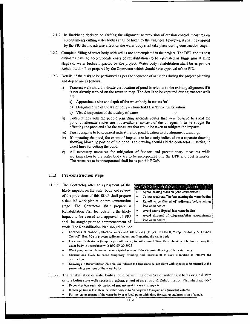
11.2.1.2 In Jharkhand decision on shifting the alignment or provision of erosion control measures onembankments cutting water bodies shall be taken by the Engineer. However, it shall be ensuredby the PrU that no adverse affect on the water body shall take place during construction stage.
11.2.2 Complete filling of water body with soil is not contemplated in the project. The DPR and its costestimates have to accommodate costs of rehabilitation (to be estimated as lump sum at DPRstage) of water bodies impacted by the project. Water body rehabilitation shall be as per theRehabilitation Plan prepared by the Contractor which should have approval of the PIU.
11.2.3 Details of the tasks to be performed as per the sequence of activities during the project planningand design are as follows:
i) Transect walk should indicate the location of pond in relation to the existing alignment if itis not already marked on the revenue map. The details to be captured during transect walkare:a) Approximate size and depth of the water body in meters 'm'b) Designated use of the water body - Household Use/Drinking/Irrigationc) Visual inspection of the quality of water
ii) Consultations with the people regarding alternate routes that were devised to avoid thepond. If alternate routes are not available, consent of the villagers is to be sought foraffecting the pond and also the measures that would be taken to mitigate the impacts.
iii) Final design is to be prepared indicating the pond location in the alignment drawingsiv) If impacting the pond, the extent of impact is to be clearly indicated on a separate drawing
showing blown up portion of the pond. The drawing should aid the contractor in setting upexact lines for cutting the pond.v) All necessary measures for mitigation of impacts and precautionary measures while
working close to the water body are to be incorporated into the DPR and cost estimates.The measures to be incorporated shall be as per this ECoP.
11.3 Pre-construction stage
11.3.1 The Contractor after an assessment of the _likely impacts on the water body and review * Avoid locating roads on pond embankmentof the provisions of this ECoP shall prepare * CollecL road runoff before enteringthewaterbodiesa detailed work plan at the pre-construction * Runoff to be fihered of sediments before lettingstage. The Contractor shall prepare a into water bodiesRehabilitation Plan for rectifying the likely * Avoid debris disposal into water bodiesimpact to be caused and approval of PIU * Avoid disposal of oil/grease/other contaminantsshall be sought prior to commencement of into water bodieswork. The Rehabilitation Plan should include:* Locations of erosion protection works and silt fencing (as per ECoP-9.0, "Slope Stability & Erosion
Control", Box 9-3) to prevent sediment laden runoff entering the water body* Location of side drains (temporary or otherwise) to collect runoff from the embankment before entering the
water body in accordance with IRC:SP-20:2002* Work program in relation to the anticipated season of flooding/overflowing of the water body* Obstructions likely to cause temporary flooding and information to seek clearance to remove theobstruction* Drawings in Rehabilitation Plan should indicate the landscape details along with species to be planted in the
surrounding environs of the water body
11.3.2 The rehabilitation of water body should be with the objective of restoring it to its original stateor to a better state with necessary enhancement of its environs. Rehabilitation Plan shall include:* Reconstruction and stabilization of embankment in case it is impacted* If storage area is lost, then the water body is to be deepened to regain an equivalent volume* Further enhancement of the water body as a focal point with place for seating and provision of shade.
11-2

* Costs of rehabilitation.
11.3.3 Concurrence of the community has to be sought on the Rehabilitation Plan prepared by theContractor. Concerns of the community have to be incorporated into the plan before submittingit for approval of the PIU
11.3.4 The PIU shall scrutinize the Rehabilitation Plan, verify the implementation on site and finallyapprove the plan. The Rehabilitation Plan should be implemented by the Contractor immediatelyafter completion of construction at the stretch near the water body
11.3.5 When there is interruption to regular activities of villagers near water body due to constructionor rehabilitation work, following are the Contractor's responsibilities:* Restriction on use of water, if any, should be intimated to the community in advance* Altemate access to the water body is to be provided in case there is interruption to use of exiting access.
The access provided should be convenient for use of all the existing users whether community or cattle* If the water body affected is a drinking water source for a habitation, altemate sources of water are to be
provided to the users during the period for which its use is affected
11.4 Construction Stage
11.4.1 It should be ensured by the contractor that the runoff entering the water body is free fromsediments
11.4.2 Silt fencing and/or brush barrier shall be installed in the drainage channels for collecting thesediments before letting them into the water body
11.4.3 Silt/sediment should be collected and stockpiled for possible reuse as surfacing of slopes wherethey have to be revegetated
11.4.4 Cutting of embankment reduces the water retention capacity and also weakens it, hence:* The contractor should ensure that the decrease in water retention should not lead to flooding of the
construction site and surroundings causing submergence and interruption to construction activities.* Any perceived risks of embankment failure and consequent loss/damage to the property shall be assessed
and the contractor should undertake necessary precautions as provision of toe protection, erosion protection,sealing of cracks in embankments. Failure to do so and consequences arising out of embankment failureshall be the responsibility of the contractor. The PIU shall monitor regularly whether safe constructionpractices near water bodies are being followed.
11.4.5 Alternate drain inlets and outlets shall be provided in the event of closure of existing drainagechannels of the water body
11.4.6 Movement of machinery and workforce shall be restricted around the water body, and no wastefrom construction camps or sites shall be disposed into it.
11.5 Post construction stage
11.5.1 With the completion of construction, the PIU has to ensure implementation of rehabilitation planfor the water body, as indicated by the Contractor.
11.5.2 The precincts of the water body have to be left clean and tidy with the completion ofconstruction.
11.5.3 Drainage channels of adequate capacity shall be provided for the water body impacted.
11-3

ECoP-12.0 Drainage
12.1 General
12.1.1 A road with good drainage is a good road. Inadequate and faulty drainage arrangements result inobstruction to natural drainage pattern. The problem is further aggravated in the low-lying areasand flood plains receiving high intensity rainfall, which can lead to the instability ofembankment, damage to pavement, sinking of foundation, soil erosion, safety hazards anddisruption in traffic. Provision of cross-drainage and longitudinal drainage increases the life ofthe road and consequently reduces water logging and related environmental impacts. Thefunctioning of the drainage system is therefore a vital condition for a satisfactory road.
12.1.2 However, construction or upgradation of CD structures and longitudinal drains is likely toincrease sediments, scour the banks, change water level and flow, and also affect the ecology ofthe surrounding area.
12.1.3 The present code shall address the environmental concerns related to d&ainage aspects duringdifferent stages of the project execution. Sub activities requiring incorporation during variousstages of project implementation and their significance levels for drainage aspects are presentedbelow in Table 12-1.
Table 12-1 Significance of Impacts Across Project RegionsRajasthan Himachal Uttar Pradesh Jha khand
Stage Key Activity Arid Other Low High Flood Other Hills Plateauareas hills hills plains areas
Project planning & Hydrological Investigationdesign Geometric Design
Pre-construction Consultations with downstreamand upstream users
Construction Sediment control measures
Post-construction Inspection and maintenance
Impacts not likely to be significantImpacts likely to be significant
12.2 Project Planning and Design
12.2.1 Drainage shall be broadly taken up as (i) Cross-Drainage and (ii) Longitudinal Drainage bothsurface & sub-surface drainage. The alignment shall be routed such that minimum drainagecrossings are encountered. Also the geometric design criteria as per IRC:SP-20:2002, foreffective surface drainage should be ensured.
12.2.2 All drains crossing the alignment shall be identified on site and marked on map whileundertaking transect walk. Basic information on the width of channel, frequency of trafficholdup and flow would provide inputs into screening of alternate alignments as well as fixing thealignment. Consultations with the community shall provide information on the HFL in the area.
12.2.3 In areas of high and medium intensity rainfall (>400 mm/year), flood prone areas and hilly areasdetailed hydrological studies will need to be conducted. The studies shall be conducted as perIRC: SP-13: 1973 "Guidelines for the Design of Small Bridges & Culverts" and IRC: SP-33:1989 "Guidelines on Supplemental Measures for Design, Detailing & Durability ofImportant Bridge Structures".
12.2.4 Design of cross-drainage structures shall be based on the inputs from the hydrological studies asper clause 12.2.3 and in other areas, the C-D structure design shall be as per IRC:SP-20:2002.
12-1
12.2.5 Design of C-D structure shall be such that:* Normal alignment of the road is followed even if it results in a skew construction of culverts and stream
bank protection are incorporated* Afflux generated is limited to 30 cm in plains with flat land slopes* It is fish friendly - fish passage is not interrupted either in upstream or downstream direction* Adequate scour protection measures for stream bank, roadway fill as head walls, wing walls and aprons are
included* Reinforced road bed (of concrete or rock) for protection against overflow in case of low water crossing
(fords/causeways) is included* The design of C-D structure should have stairs leading to the bed of the drainage channel, for regular
inspection of the sub-structure
12.2.6 Schedule of construction of C-D structures should be confined to dry months to avoidcontamination of streams
12.2.7 Longitudinal drains are to be designed to drain runoff from highest anticipated rainfall as perrainfall data for the past 20 years or 50 years as per hydrological analysis in high rainfall areas(annual rainfall > 1000 mm) and hill areas. For design of longitudinal drains in other areas, thedesign shall be as per IRC:SP-20:2002.
12.2.8 Outfall of the roadside drains shall be into the nearby stream or culvert. The outfall should be atsuch a level that there would be no backflow into the roadside drain. Wherein pond/low lyingareas exist in the vicinity, the flow, may be diverted into them after removal of sediment forpossible ground water recharge.
12.2.8.1 Incase of Himachal Pradesh, if no natural stream is found appropriate for roadside drainoutfall, water-harvesting structures shall be constructed to collect the runoff. The location shallbe deternined based on the size of the structure (which in turn depends on the dischargeanticipated) and willingness of the landowner who would be utilizing the collected water.These shall be determined by the PIU in consultation with the landowner during projectpreparation stage.
12.2.9 The roadside ditches in high rainfall areas (annual rainfall > 1000mm) and hill areas, shall belined to protect from runoff of high velocities.
12.2.10 In case of high embankment (>I.Om) or bridge approaches, lined channels shall be provided todrain the surface runoff, prevent erosion from the slopes and avoid damage to shoulders andberms. Detailed specifications shall be as per IRC:SP-20:2002.
12.3 Pre-Construction Stage
12.3.1 Following measures are to be undertaken by the contractor prior to the commencement ofCD/Bridge construction:* The downstream as well as upstream user shall be informed one month in advance* The contractor shall schedule the activities based on the nature of flow in the stream.* The contractor should inform the concerned departments about the scheduling of work. This shall form part
of the overall scheduling of the civil works to be approved by PIU.* Erosion and sediment control devises are to be installed prior to the start of the civil works.* Interceptor drains to be dug prior to slope cutting to avoid high runoff from slopes entering construction
sites in case of hill roads* Runoff from temporary drains and interceptor drains to be directed into natural drains in hill roads* In case of up-gradation of the existing CD Structures, temporary route / traffic control shall be made for the
safe passage of the traffic, depending upon the nature of the stream* All the safety/warning signs are to be installed by the contractor before start of construction
12.3.2 In case of utilization of water from the stream, for the construction of the CD structures, thecontractor has to take the consent from the concerned department (refer ECoP-8.0, "Water forConstruction")
12-2

12.4 Construction Phase
12.4.1 Drainage structures at construction site shall be provided at the earliest to ensure propercompaction at the bridge approach and at the junction of bridge span and bridge approach.
12.4.2 In hill areas sub-surface drains, if required, shall be provided immediately after cutting theslopes.
12.4.3 Velocity of runoff to be controlled to avoid formation of rills/gullies as per ECoP-9.0, "Slopestability & erosion control"
12.4.4 While working on drainage channels, sediment control measures shall be provided. Silt fencing(as per the detailed specifications of ECoP-9.0, "Slope Stability & Erosion Control") shall beprovided across the stream that carries sediment.
12.4.5 The sediments collected behind the bunds shall be removed and after drying, can either bereused or disposed off as per ECoP-10.0, "Waste Management"
12.4.6 Safety devises and flood warning signs to be erected while working over §treams and canals
12.5 Post Construction
12.5.1 Inspection and cleaning of drain shall be done regularly to remove any debris or vegetativegrowth that may interrupt the flow.
12.5.2 HFL should be marked as per hydrological data on all drainage structure
12.5.3 Temporary structure constructed during construction shall be removed before handing over toensure free flow through the channels.
12.5.4 The piers and abutments should be examined for excessive scour and make good the same ifrequired.
12.5.5 In case of Causeway following aspect shall be taken into consideration:* Dislocation of stones in stone set pavements, scouring of filler material due to eddy currents.* Floating debris block the vents. Incase of large amount of floating material, debris arrestor shall be provided
in upstream side.* Damage to guide stones, information board shall be inspected and replaced accordingly.
12.5.6 Schedule of Inspection shall be drawnup for checking cracks, settlements and unusualbackpressures. It must be ensured that all the rectification shall be undertaken as and whenrequired. Following are broadly the items to be checked:* Settlement of piers/abutments & settlement of approach slabs have to be checked* Cracks in C-D structures or RCC slabs* Drainage from shoulders to be ensured* Ditches & drains to be kept clean of debris or vegetation growth* Repairs to parapet of culverts whenever required are to be undertaken
12-3

ECoP-13.0 Construction Plants & Equipment management
13.1 General
13.1.1 During execution of the project, construction equipments, machinery and plants always haveimpact on the environment. The impact can be due to the emissions, dust, noise and oil spills,that concern the safety and health of the workers, surrounding settlements and environment as awhole. This code of practice describes the activities during the project stages where pollutioncontrol measures are required. Table 13-1 highlights the key activities that need to be addressedduring the project and also the significance of impacts in the project region.
Table 13-1: Significance of Impacts Across Project RegionsSignificance of Impacts
Stage Key ActRajasthan Himachal Uttar Pradesh JharkhandStages Key Activities Othe Flo .teArid Other Low High Flood Other Hills Plateau
Project Planning & Eqipen SeetoDesign Stage Equipment Selection
Awareness of SafetyPre-construction Stage Among Workers
Safety devices &
Construction Stage Cautionary Signs ._-_.Waste Disposal
Restoration of Plant Site /Post-construction Stage Haul Roads _
Impacts not likely to be significantImpacts likely to be significant
13.2 Project Planning and Design Stage
13.2.1 Selection criteria for setting up a plant area and parking lot for equipments and vehicles shall bedone as per siting criteria for construction camp specified in ECoP-3.0, "Construction Camps"
13.2.2 Section 4, Part -I General Condition of Contract specified in Standard Bidding Document forPradhan Mantri Gram Sadak Yojana (PMGSY) shall be adhered to during the preparation ofbidding document.
13.3 Pre-construction Stage
13.3.1 The Contractor must educate the workers to undertake safety precaution while working at theplant / site as well as around heavy equipments as per Clause 14.3.2, Section 14.3, ECoP-14.0,"Public and Worker's Health & Safety".
13.3.2 Before setting up the crusher, hot-mix plant and generator, the Contractor shall acquire "NoObjection Certificate (NOC)" from the State Pollution Control Board for the same.
13.3.3 The Contractor shall ensure all vehicles must possess Pollution Under Control (PUC) Certificate,which and shall be renewed regularly.
13.3.4 The Contractor must ensure that all machinery, equipments, and vehicles shall comply with theexisting Central Pollution Control Board (CPCB) noise and emission norms.
13.3.5 The PIU must ensure that the Contractor shall submit a copy of the NOC and PUC Certificatesbefore the start of work.
13.3.6 The Contractor shall design the service road with protection measures as black topping atvulnerable points as in low lying areas.
13-1

13.4 Construction Stage
13.4.1 The Contractor shall undertake measures as per Table 13-2 to minimize -the dust generation,emissions, noise, oil spills, residual waste and accidents at the plant site as well as duringtransportation of material to construction site.
Table 13-2: Measures at Plant Site
Concern Causes Measures
* Water sprinkling
Vehicle Movement &* Fine Materials shall be Transported in Bags or Covered by TarpaulinVehicle Movement
during Transportation
Dust Generation * Tail board shall be properly closed and sealed
Crushers * Water Sprinkling
Conret-Mi Pl * Educate the workers for following good practices while materialConcrete-Mix Plant
handling
* Site Selection as per Clause 6.5.2, Section 6.5, IRC's Manual for
Construction & Supervision of Bitumen WorkHot-Mix Plant tr
Emissions . Regular maintenance of Dust Collector as per manufacture'srecommendations
Vehicles * Regular maintenance as per manufacture's recommendation
Generators * Exhaust vent of long length
Heavy Load Vehicles * Exhaust silencer, Regular maintenance as per manufacture schedule
Noise Crushers * Siting as per ECoP-3.0, "Construction Camps"
Generators * Shall be kept in closed room and regular maintenance as permanufacture's recommendation
Oil Spills Storage and Handling * Good practice,* ECoP-10.0, "Waste Management"
Residual waste Dust Collector and * ECoP-10.0, "Waste Management"
Concrete waste Concrete-Mix plant * ECoP-10.0, "Waste Management"
Bitumen and Hot-mix Plant . ECoP-10.0, "Waste Management"bitumen mix
Stone chips Crushers * ECoP-10.0, "Waste Management"
Trajectory of * No worker shall be present in the vicinity of the equipmentsEquipmentsMovable Parts ofEquipments * Caution Sign, awareness among workersEquipments
Safety Plant Area / Site * Caution Sign, Safety Equipments
Accidents / Health * First Aid Box, Periodic Medical Check up
Break down ofvehicles . Arrangement for towing and bringing it to the workshop
13.4.2 During site clearance, all cut and grubbed materials shall be kept at a secured location so that itdoes not raise any safety concerns.
13.4.3 During excavation, water sprinkling shall be done to minimize dust generation.
13.4.4 Frequent water sprinkling shall be done on the haul roads to minimize dust generation. Incase ofloose soils, compaction shall be done prior to water sprinkling.
13.4.5 Cautionary and informatory sign shall be provided at all locations specifying the type ofoperation in progress.
13-2

13.4.6 The contractor must ensure that there isminimum generation of dust and wastewhile unloading the materials from trucks. * The Contractor shall ensure that bitumen storing,
13.4.7 The construction waste generated shall be handling as well as mixing shall be done at hot-mixplant or designated areas' to prevent contamination
disposed as per ECoP-10.0, "Waste ofsiangrudwer, ~~~~of soil and ground water.
Management". * Skilled labour shall be used while hand placing the
13.4.8 The equipments, which are required to move pre-mixed bitumen material. The hand placing ofpre-mixed bituminous material shall be done only
forward and backward, shall be equipped in following circumstances:with alarm for backward movement. It shall o For laying profile corrective courses of
be ensure that the workers shall remain irregular shape and varying thickness
away from the working areas at such times. o In confined spaces where it is impracticablefor a paver to operate and
13.4.9 The PIU shall carry out periodic inspections o For filling potholesto ensure that all the pollution control * The Contractor shall provide safety equipments i.e.
systems are appropriately installed and gumboots and gloves to the workers while handlingcomply with existing emission and noise bitumen.norms. * While applying Tack Coat, spraying of bitumen
shall be done in the wind direction. The labour
13.5 Post-construction stage: shall wear jacket while spraying the bitumen.* All the bituminous work shall be done as per IRC's
13.5.1 The PIU shall ensure that all the haul roads Manual for Construction and Supervision of
are restored to their original state. Bituminous Works.
13.5.2 Incase any inner village road is damaged while transporting the procured material; the contractor
shall restore the road to its original condition.
13.5.3 The PIU must ensure that the decommissioning of plant shall be done in environmentally sound
fashion and the area to brought to its original state.
3 Designated area refers to paved surfaces and barren parcels of land, with adequate drainage and disposalsystem. It must be ensure that these are away from agriculture land, water body and other sensitive areas.
13-3

ECoP-14.0 Public and Worker's Health and Safety
14.1 General 'Safety C4 ae6 ,F- .
14.1.1 The safety and health concerns of the General Public due to:workers and the general public are * Improper scheduling of construction activities especiallyimpacted due to the hazards created near the settlements and sensitive areas
* Parking of equipments and vehicles at the end of the dayduring the construction of road. likely to cause accidents to the general public especially
14.1.2 This code of practice describes the during night hours.hazards and measures that need to be * Transportation of uncovered loose material or spillage of
taken to mitigate the impacts. Table material increases the chances of accidents to road userstaken to mitigate the Impacts. Table and surrounding settlements.14-1 highlights the key activities that Workers due to:
need to be addressed during the * Improper handling of materials like bitumen, oil and otherdifferent project stages and also the flammable material at construvtion sites, likely to causesignificance of impacts in the project safety concerns to the workers.regions. . Lack of safety measures such as alarm, awarness and
safety equipment result in accidents, especially workingwith or around heavy machinery / equipments.
Table 14-1 Significance of Impacts Across Project Regions
Significance of ImpactsStages Key Activities Rajasthan Himachal Uttar Pradesh Jharkhand
Arid Other Low High Flood Other Hills Plateauareas hills lhills plains areas
Project Planning & Safety considerations duringDesign Stage design :Pre-construction Safety & traffic controlStae-onstruction measures in constructionStage schedule
Safety at site .Construction Stage Public safety =
Post-Construction Provision of signagesStage Impactslikely tobesignificant
Impacts not likely to be significant
Health Concerns are adversely impacted.............;:14.2 Project Planning and Design Public due to:
* Unhygienic conditions due to water logging, either byStage improper decommissioning of Construction Camps and
14.2.1 To address health and safety concenns, parking lots, or improper disposal of constructionthe DPR shall contain selection criteria wastes, leading to the breeding of vectors that are likely
to impact the health of the general publicfor setting up: * Interaction between workers and host community is* Construction Camps (as per ECoP-3.0, likely to increase the risk of spread of communicable
"Construction Camps") diseases.* Borrow Areas (as per ECoP-5.0, "Borrow Workers due to:
Area") and * Low quality drinking water as well as inappropriate* In case of opening new quarry areas (as storage of drinking water likely to cause water bome
per ECoP-7.0, "Quarry Areas") diseases among workers.
14.2.2 To address the safety concerns to road * Absence of proper sanitary facility likely to act as auser during operational phase, the DPR breeding ground for vectors raising health concemsshall contain the following: among workers.
Selection and location of regulatory as well as informatory signs as per IRC: 67-2001, depending upon thegeometry of the road.
14-1

* Incase of hill roads, provision of passing places and parapet wall shall be included in road design
14.3 Pre-construction stage
14.3.1 Inorder to incorporate public health and safety concems, the PrU and the Contractor shalldisseminate the following information to the community:* Location of construction camps, borrow areas and new quarry areas.* Extent of work
* Time of construction
* Diversions, if any
* Precaution measures in sensitive areas* Involvement of local labours in the road construction* Health issues - water stagnation, exposure to dust, communicable disease* Mechanism for grievances
14.3.2 The Contractor must educate the workers to undertake the health and safety precautions. Thecontractor shall educate the workers regarding:* Personal safety measures and location of safety devices.* Interaction with the host community
* Protection of environment with respect to:o Trampling of vegetation and cutting of trees for cooking
Restriction of activities in forest areas and also on huntingWater bodies protectionStorage and handling of materialsDisposal of construction waste
14.4 Construction Stage
14.4.1 During the progress of work, following are _th saet reureet tha nedtobthe safety requirements that need to be * First Aid Kit, distinctly marked with Red Cross on
undertaken by the contractor at the white back ground and shall contain minimum ofconstruction site: following:* Personal safety equipments (such as footwear o 6 small-sterilized dressings
and gloves) for the workers o 3 medium and large sterilized dressings* All measures as per bidding document shall be o 1 (30 ml.) bottles containing 2 % alcoholic
strictly followed solution of iodine* Additional provisions need to be undertaken o 1(30 ml) bottle containing salvolatile
for safety at site: o I snakebite lanceto Adequate lighting arrangement o I pair sterilized scissors
Adequate drainage system to avoid any o I copy of first-aid leaflet issued by thestagnation of water Director General, Factory Service & LabourLined surface with slope 1:40 (V:H) and Institute, Government of Indiaprovision of lined pit at the bottom, at the o 100 tablets of aspirinstorage and handling area of bitumen and o Ointment for burnsoil, as well as at the location of generator o A suitable surgical antiseptic solution(grease trap). ' Adequate arrangement shall be made for immediateFacilities for administering first aid recoupment of the equipments, whenever
14.4.2 The following measures need to be adopted necessary.by the contractor to address public safety * A trained personnel incharge of first aid treatmentconcems: to be readily available during working hours atconcerns: ~~~~~~~~~~~construction site* The Contractor shall schedule the construction cos transpt tactivities taking into consideration factors such Suitable transport to the nearest approachable
as: ~~~~~~~~~~~~hospital should be made available.as:o Sowing of cropso Harvesting
Local hindrances such as festivals etc.
14-2

c Availability of labour during particular periods* All the cautionary signs as per IRC: 67-2001 and traffic control devices (such as barricades, etc) shall be
placed as soon as construction activity get started and shall remain in place till the activities get completed.* Following case specific measures need to be followed during the progress of the activity:
o Incase of blasting, the Contractor must follow The Explosives Rules, 1983.o Incase of construction activity adjoining the water bodies, measures shall be taken as per ECoP-11.0,
"Water Body"
If construction of road is within the settlement, the contractor must ensure there shall not be anyunauthorized parking as well as storage of material, adjacent to road.X Approved chemicals should be sprayed to prevent breeding of mosquitoes and other disease-causing
organisms, at all the water logging areas
14.4.3 The PIU shall carry out periodic inspections in order to ensure that all the measures are beingundertaken as per the ECoP.
14.5 Post-construction Stage
14.5.1 During this stage a major concern is on road user safety. Following are the measures that need tobe undertaken by the PIU to ensure safer roads:* Inspection and maintenance of installed regulatory and informatory signs.* Ensure that the location of signage does not obstruct the visibility* Incase of hill roads, maintenance of parapet wall as well as of overtaking zones.
14.5.2 The PIU must ensure that during the maintenance operation of road, road materials are stored ata location such that they shall not create any risk to road users.
14.5.3 The construction site shall be cleaned of all debris, scrap materials and machinery on completionof construction for the safety of public and road users, as per the ECoP-3.0, "ConstructionCamp" and ECoP-10.0, "Waste Management."
14-3

ECoP-15.0 Cultural Properties
15.1 General
15.1.1 The cultural properties located close to the road are likely to be impacted by the roadconstruction. Most of the properties are avoided in general during finalization of alignment.Table 15-1 below highlights the key activities that need to be addressed during different stagesof the project and also the significance of the impacts in the project regions
Table 15-1: Significance of Impacts Across Project RegionSignificance of Impacts
Stages Key Activities Rajasthan Himachal Uttar Pradesh JharkhandArid Other Low High Flood Other Hills Plateau
areas hills hills plains areasIdentification of Cultural
Project Planning Properties& Design Avoidance/mitigation -;
measuresConstruction Precautionary measuresPost- Restoration of impactedConstruction cultural properties _
Impacts not likely to be significant
15.2 Project Planning and Design Stage
15.2.1 Measures for mitigation of impacts on cultural properties during project preparation shall be asper the following steps:* Identification of locally significant cultural properties should be done* Assessment of likely impacts on each cultural property due to project implementation* The extent of impact on the identified culture property should be assessed and possible measures for
avoidance should be devised based on the site investigation.
15.2.2 Incase impact is not avoidable, identification Information to be collected... -
of alternative routes or possibility of * Locationrelocation of the culture property shall be * Direction (North/ South/East/West) With Respectassessed in consultation with the local to Roadpublic, based on the economic feasibility. * Distance of the structure from existing centerline of
the road15.2.2.1 In case of Rajasthan, no relocation would * Type of Property eg: temple/mosque/shrine/dargah
be taken up and alignment shall be shifted etcaway from the cultural property to avoid * Plan of the structureany impacts. * Importance of the structure -
15.2.2.2 In Jharkhand, the Engineer shall decide historical/social/archeological* Ownership of the propertyupon alignment changes or relocation of * Probable loss to the propertycultural property during planning and . Specific periods/durations in which largedesign stage. congregations as festivals/mela take place causing
hindrance to vehicular movement15.2.3 Incase of relocation, relocated site should be * Choice of community, issue of relocation
suggested by the local people and the size ofrelocated structure should at least be equal to the original structure.
15.2.4 A detailed design of the relocated structure and its site plan along with the necessary BoQ are tobe presented DPR. A sample of the drawing for relocation of cultural property and sample BoQis presented in Annexure 15-1.
15-1

15.2.5 The relocation and other avoidance measures should be carried out before the start of the roadwork
15.2.6 It must be ensured by the PIU that the BoQ and rates are incorporated into the contractdocument.
15.3 Construction Stage
15.3.1 Major impacts on the properties during this stage are mainly due to movement of constructionmachinery as well as due to construction activity in the vicinity of the cultural property.Following are precautionary measures that need to be undertaken by the contractor whileworking near these structures:* Provision of temporary barricades to isolate the precincts of the cultural property from the construction site
except in Jharkhand where site specific measures shall be devised by the Engineer to avoid impacts.* Restrict movement of heavy machinery near the structure* Avoid disposal or tipping of earth near the structure* Access to these properties shall be kept clear from dirt and grit
15.3.2 During earth excavation, if any property is unearthed and seems to be culturally significant orlikely to have archeological significance, the same shall be intimated to the Engineer. Work shallbe suspended until further orders from PIU. The State Archeological Department shall beintimated of the chance find and the Engineer shall carry out a joint inspection with thedepartment. Actions as appropriate shall be intimated to the Contractor along with the probabledate for resuming the work.
15.3.3 The PIU must ensure that the contractor implements the precautionary measures as suggested.
15.4 Post Construction Stage
15.4.1 Immediately after completion of construction, the Contractor will affect clearance of theprecincts of cultural properties.
15.4.2 Incase access to any of the cultural properties is severed during construction; it needs to berestored at the Contractor's cost.
15.4.3 The PIU shall certify restoration of all road links as well as relocated properties before finalpayment is made.
15-2

ECoP-16.0 Tree Plantation
16.1 General
16.1.1 Section 21.4 of PMGSY guidelines specifies that the state governments would take up theplanting of fruit bearing and other suitable trees, on both sides of the roads from their own funds.Besides improving aesthetics and ecology of the area, the trees provide fuel wood, act as noisebarriers, provide visual screen for sensitive areas and also generate revenue by sale of itsproduce. However certain precaution must be taken in design of avenue or cluster plantation sothat the trees do not have an adverse impact on road maintenance and/or on safety of the roadusers. This code of practice elaborates on the approach towards planting trees on PMGSY roads.Emphasis has been laid on a greater involvement of communities and Gram Panchayats inplanting and maintenance of roadside trees. The activities requiring addressal during the projectstages and the significance of impacts in the project region are presented in Table 16-1.
Table 16-1: Significance of Impacts Across Project RegionSignifil ance of Impacts
Stages Key Activities Rajasthan Himachal Uttar Pradesh JharkhandStage ectOther Low High Flood Other Hills Plateau
Ard Areas Hills Hills Plis Areas Hil PatuMinimising treefelling __.
Project Planning Plantation& Design Stage Strategies
Consultation with_____ ____ ____ PR Is_ _ _ __ _ _ _ _ _
Post- Maintenance ofcoStageuon trees
Impacts not likely to be significantImpacts likely to be significant
16.2 Project Planning and Design Stage
16.2.1 During alignment finalisation, due Plmnt-trees alokgroacds where thereLs.. -Wt,
consideration shall be given to minimise the * Availability of land for plantingloss of existing tree cover, encroachment of * Availability of waterforest areas / protected areas etc as specified * Willingness of PRI to nurture the saplingsin ECoP-1.0, "Project Preparation". Tree felling, if unavoidable, shall be done only aftercompensatory plantation of at least three saplings for every tree cut is done. This shall be carriedout by the PIU immaterial of the legal requirements of the state.
16.2.2 A roadside landscape plan shall be prepared by the PIU as part of the DPR, and finalised inconsultation with the State Forest Department and PRI. The plantations shall be in accordancewith the IRC:SP:21-1979 Manual on Landscaping and IRC :66-1976. The plan may be in the
form of avenue trees or cluster plantation. It should be ensured that plantation is carried out onlyin areas where water can be made available during dry seasons and the plant can be protectedduring the initial stages of their growth. The species shall be identified in consultation withofficials of forest department, giving due importance to local flora, It is recommended to plantmixed species in case of both avenue or cluster plantation. The saplings for plantation shall besupplied by the Forest Department.
16.2.3 Consultations shall include the role of the PRIs in maintaining and managing the trees to beplanted in the project. A MoU shall be signed between the Gram Panchayat, PIU and ForestDepartment towards maintenance of the trees, and empowering the PRIs to be entitled to anyrevenue generated out of these trees. Format for the MoU is attached as Annexure 16-1. It shall
16-1

be the responsibility of the Gram Panchayats through the Development Committees to work outinstitutional mechanisms for managing the plantation and upkeep of trees.
16.2.4 The plantation strategy shall suggest theplanting of fruit bearing trees and othersuitable trees. Development of cluster * Within the line of sight around junctions
* On the inside of curvesplantations will be encouraged in the Gram * thinside of thesSabha lands, at locations desired by the
community. The choice of species will be based on the preferences of the community.
16.2.5 In arid areas of Rajasthan, shelter-belt plantation shall be proposed as wind breaks, throughplanting of local hardy shrub and grass species in preference to plantation of trees. The locationsof these shelter-belt plantations shall be decided by the PIU in consultation with the PRI andState Forest Department after considering the wind direction, velocity and the likely movementpatern of sand dunes.
16.2.6 The PIU shall identify the nursery locations in consultation with the State Forest Department.Fruit bearing indigenous species requiring less maintenance shall be chosen to ensure a highersurvival rate.
16.3 Post-construction stage
16.3.1 Planting of saplings from the nurseries as per the landscape plan and the subsequent maintenanceof the trees planted shall be carried out by the PRI, with its own funds. Planting shall beundertaken immediately after rainy season or initial weeks of spring. The activities to be takenup by the PRI as part of maintenance shall include (i) cutting/lopping branches up to a height of2.5m above ground level to ensure visibility (ii) Removal of dead wood from the roadway andstoring away from roads, and (iii) Weed cutting from shoulders and keeping the shoulders freefrom any growth of vegetation. In addition, the PRI is to ensure a healthy survival rate byplanting replacement saplings in cases where the survival rate is less than 80%.
16.3.2 Watering of trees during the initial period of two to three years shall be the responsibility of thePRI or the agency designated by it. Final payment, if any, shall be on the basis of the number oftrees surviving at the end of three years of initial plantation. The shoulders of the road shall bekept clear of weeds or any undesirable undergrowth, which may hinder free flow of traffic.
16.3.3 It needs to be ensured that the branches of the trees do not obstruct clear view of theinformatory and caution signs
16.3.4 Deciduous trees shed leaves every season. It is necessary to keep the roadway clear of suchdebris.
16.3.5 Some gaps should be left even in avenue plantation to ensure that the carriageway dries up earlyafter an occasional shower.
Note: The species of trees to be planted has not been suggested, as this should be decided in consultationwith the State Forest Department for the particular region.
16-2

ECoP-17.0 Managing Induced Development
17.1 General
17.1.1 Rural lands have a distinct character consisting of productive farmiands with natural areas andlimited residential settlement. Developments allowed to grow along the village roads, unlessplanned and regulated, have the potential to generate traffic and pedestrian movements that canlead to unsafe traffic conditions. Lack of planning controls in the rural areas has allowedroadside development, ranging from individual commercial establishments to continuousstretches of ribbon developments. This code of practice provides measures for regulating theland uses along the roads and tackling induced developments likely along the PMGSY roads.The measures suggest a greater involvement of the Village Panchayats and the Road Authoritiesfor the PMGSY roads. The measures suggested are in accordance with the roles andresponsibilities of the PRIs as suggested in the 73d Amendment Act, 1992 and the respectiveState Panchayat Acts.
17.2 Project Planning and Design Stage
17.2.1 As part of the design stage, the PIU shallidentify areas that are susceptible to induceddevelopment impacts. These locations will * Lands within 50m ofjunctionsbe finalised in consultation with the Gram * Agricultural lands within lOOm of settlementsSabha. It shall be the responsibility of the * Stretches within lOOm of temples, weekly fairs andPIU to educate the community on the safety locations of community mass gatheringsissues due to ribbon development.
17.2.2 The designs of the road shall be such that the access points conform to certain minimumgeometric standards.
17.2.3 The dissemination of the roles and responsibilities of the Village Panchayats in regulatingdevelopment along the rural roads will be ensured by the PIU.
17.3 Operation stage
17.3.1 The Gram Panchayat shall lay downrestrictions on building activities along therural roads. Towards this, the recommendedstandards for building lines and control lines * Repair shops & Petty shopsshall be followed as stipulated in Table 2.4 * Commercial establishments within settlementsof IRC: SP: 20-2002. * Basic amenities - health, education, water pumps
17.3.2 Development of Residential Sites Outside * VillagelevelpublicbuildingsExisting Settlement: Apart from the X Selling of produce, informal marketsadoption of the recommended standards for * Developments around specific areas as waterbuilding lines, the Gram Sabha shall bodies, cultural propertiesencourage local development through * Formal markets & agro-processing unitseducation to the communities to construct property with setback from the road rather than on theroad.
17.3.3 Development of Repair Shops, Petty Shops at Junctions: A road junction, especially at locationswhere the village road meets a district road is a typical site where such repair shops, petty shopstend to come up. The Gram Panchayat shall ensure that no such shops or structures come up
17-1

within the line of sight. Areas for their development shall be demarcated and parking facilitiesshall be provided to encourage them developing away from the road.
17.3.4 While deciding upon the location of community assets, the following preventive measures toaddress possible induced impacts shall be taken up:* The area around the bus stops has the potential to induce growth of kiosks and petty shops. While this is
unavoidable and also desirable (to minimize the impact on the road), such growth needs to be encouragedaway from the road.
* Community sources of water such as hand pumps are generally sited on the shoulders. It shall be theresponsibility of the Gram Sabha to identify lands outside the RoW and identify any suitable gram Sabhaland accessible from the road. This approach would achieve (i) Safety and (ii) Damage to the road due towater logging, usually around such water sources.
17.3.5 The Gram Sabha shall follow the principles given hereunder while planning and developingsmall markets / fairs, which include the selling of agricultural produce:* Restricting or planning the activity to one side of the road to minimise pedestrians crossing the road* Provide parking areas if necessary, and clearly delineating the parking areas from the road* Providing a good visibility on the approaches to the market area.* These sites should not be within 150m of the access or egress points of a major junction.* The commercial areas should be preferably planned lateral to the road than in parallel direction
17.3.5.1 In case of Himachal Pradesh, road width and control width will be fixed by the road authorityafter its declaration as a scheduled road. In Rajasthan the power to fix the control and buildinglines vests with the road authority under Highways Act. In case of Uttar Pradesh, PRI shall bemotivated towards avoidance of encroachments on the roads. However, decisions on managinginduced development shall be taken by the "Bhumi Prabhandhak Samiti" of the Govt. of UP.
17.3.6 The Gram Sabha shall take up appropriate measures towards the removal of encroachments ontothe public land.
17.3.7 The concems of the communities, about the traffic speed and/or volume through the villages areusually addressed through traffic calming schemes such as road humps or speed breakers/rumblestrips along the road. The PIU shall incorporate traffic calming schemes in the design aimed atchanging the driver's visual perception of the road environment, as they enter the village, so thatthey adjust their driving style to better navigate any obstacles encountered. However, suchcalming devices shall be provided only in the event of provision of adequate signages andpavement marking.
The 73td Amendment Act, 1992, endows the Panchayats with such powers and authority, as may be necessaryto enable them to function as institutions of self-government. The act entrusts the responsibility to the VillagePanchayat, planning and implementation of schemes for economic development and social justice as listed inthe Eleventh Schedule (243G) of the Constitution. This has been reflected in the State Panchayat Acts asfollows.
Himachal Pradesh: The Himachal Pradesh Panchayati Raj (Amendment) Act, 1991 provides for thefollowing:* Entrust to the panchayats the responsibility of preparation and implementation of schemes for promoting economic
development and social justice, including those on subjects listed in Eleventh Schedule of the Constitution of India.Further,
* Empowers the Gram Panchayat to remove encroachments.* Enables the Gram Panchayats to regulate building construction through preparation of a model schemes for the
village.* Towards the implementation of these measures, an Amenities Committee be constituted for education, public health,
public works and other works
Rajasthan: The Rajasthan Government has transferred the functions as per the Eleventh Schedule to the PRIsin 1959. Further, the Rajasthan Panchayati Raj Act, 1994 provides for constitution of a Social Services and
17-2

Social Justice Committee, which shall include the management of health, education, roads etc.Uttar Pradesh: The UP Kshetra Panchayat and Zilla Panchayat Adhiniyam, 1961, as amended in 1994,provides guidelines for the activities to be discharged by the Panchayats:
A Gram PanchayaL shall prepare every year a development plan for the panichayat area and submit the same to theKshetra Panchayat.
* A Gram Panchayat shall have control of all public streets situated within its jurisdiction, not being a private street.* Every Gram Panchayat shall also be the Bhumi Prabandhak Comnittee and shall discharge the duties of upkeep,
protection and supervision of all properties held by the Gram Panchayat. A Gram Panchayat is empowered to frameby-laws to:o Prevent damage to public streets and propertyo Prohibit or regulate the use ofpublic streets or public places by individualso Regulate any other duties or functions of the Gram Panchayat, which shall include development of haats,
bazaars, development of abadi sites and any other matter related to control of development.
17-3
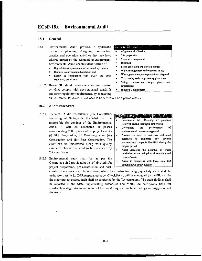
ECoP-18.0 Environmental Audit
18.1 General
18.1.1 Environmental Audit provides a systematicreview of planning, designing, construction * Alignment finalizationpractice and operation activities that may have * Site preparationadverse impact on the surrounding environment. * Material managemenEEnvironmental Audit enables identification of: * Drainage* Degradation/limprovement of surrounding ecology * Slope protection and erosion control
, Damage to suoundinghabita* Water management and economy of use* Damage to surrounding habitation and I .* Extent of compliance with ECoP and other * Waste generation, management and disposal
regulatory provisions * Tree cutting and compensatory plantation* Siting construction camps, planLs and
18.1.2 Hence PIU should assess whether construction equipmentsactivities comply with environmental standards * Induced Developrtontand other regulatory requirements, by conductingan Environmental Audit. These need to be carried out on a periodic basis.
18.2 Audit Procedure
18.2.1 Technical Audit Consultants (TA Consultant) ~consisting of Safeguards Specialist shall be * Determines the efficiency of practicesresponsible for conduct of the Environmental followed during execution of the workAudit. It will be conducted in phases * Determines the performance ofcorresponding to the phases of the project such as environmental measures suggested(i) DPR Preparation, (ii) Pre-Construction (iii) * Asseses the need to undertake additionalConstruction and (iv) Post Construction. The measures to minimize any adverseaudit can be undertaken along with quality environmental impacts identified during theassuditancbe hecks rthatkeed along be cduahte y project periodassurance checks that need to be conducted by * Audit develops the potential of wasteTA consultants. minimnization and adoption of recycling and
18.2.2 Environmental audit shall be as per the .reuseofwaste.Checklist-1 & 2 provided in the ECoP. Audit for n Assist in complying with local, state andproject preparation, pre-construction and post-
construction stages shall be one time, while for construction stage, quarterly audit shall beundertaken. Audit for DPR preparation as per Checklist -1 will be conducted by the PIU and forthe other project stages, audit shall be conducted by the TA consultant. The audit findings shallbe reported to the State implementing authorities and MoRD on half yearly basis forconstruction stage. An annual report of the monitoring shall include findings and suggestions ofthe Audit.
18-1

Check list-1: Audit Checklist for DPR PreparationIIResponse
SI. No. Items for inclusion in DPR Yes No NA Indicate Attachments_____ _ ______ _______ ______ _____I_I__I_I nu m ber
I. Transect WalkIs transect walk conducted for finalizing the _ MapofTrapnseTct_Walk
I alignment? M oIf. Initial Consultations2 Are consultations conducted with community Suggestions received from community
before alignment finalisation
2.1 Suggestions received on the proposed Write up on suggestions received analignment response of PIU
2.2 Consent of land owners towards voluntary land Attach gift deeds/MoUdonation
3 Are suggestions received from community beenincorporated into design
Reasons for not incorporatin3.1I Only few suggestions are incorporated suggestions from community3.2 Are reasons for not incorporating suggestion. been communicated to the community -.,
III. Identification of PAPs4 Are type and extent of losses due to projec
identified_ Are PAPs due to the project identified List of PAPs and loss suffered due to
5 Are PAPs due to the project identified - the project6 Are vulnerable PAPs identified with respect tc6 following:6.1 BPL
6.2 Marginal land owner (less than 3-1/8 acres andlosing 10% of residual land) _
6.3 WHH6.4 SC/ST6.5 Handicapped7 Are grievances reported List of grievances and PAPs7.1 Type of concerns or grievances Mechanism for grievance redressal7.2 Residual grievances if any Reasons for non addressalIV. R&R actions
_ Ar poisosolsssbenmaeDetails of Entitled PAPs and8 Are provisions for losses been made provisions
Are provisions of alternate land site made for8.1 the identified entitled/vulnerable PAPs losing Details of PAPs and land provided
land and structure8.2 Are provisions made for altemate land for ST Details of PAPs and type of provision
in scheduled areas under PESA as per PESAAre provisions made for inclusion of PAPs Details of PAPs and schemes unde
8.3 losing land/shelter/livelihood under any which they are includedongoing Rural Development scheme _
List of encroachers/squatters an8.4 Are provisions made for illegal occupants provisions
Anfly consultation during implementation work Type of consultation & issue9 addressed9. 1 Migrant labourers and construction camps9.2 Health issues including HIV/AIDSV. Environmental Clearances10 Environmental clearances to be obtained, ifCopy of Clearance obtained
required
10.1 SPCB Copy of application form submitted i10.2 Forest Department clearance is pending10.3 MoEF (in case of black topping in Himachal)VI. Surveys ConductedI I Are detailed surveys conducted for the project | Information presented in DPR
11.1 Geological Studies11.2 Hydrological Studies11.3 Topographical Studies
It 4 Was peg marking carried out to delineate theproposed alignment _
18-2

ResponseSI. No. Items for inclusion in DPR Yes No INA ndicate Attachments
I I I numberVII. Loss of common property resources
Are provisions made to community losin Type of loss and arrangements madecommon property or assets, if any Type_of_oss_andarrangemnts_mad
13 Are provisions for relocation of culturaproperties been made ..
VIII. Material source identification, extraction andrehabilitation
Are provisions made in specifications for14 identification of borrow areas to reduce cos
and use waste materials15 Are provisions made for rehabilitation o
borrow areas in the DPR/SpecificationsWere sources of alternate materials explored o
16 provisions made for utilizing them, incase lead Properties of alternative matenals anfor stone ballast is excessive, to reduce cost an extent of utilizationuse waste materials.
17 Is material from existing quarries in sufficien17 uantities for the projectIf answer to No. 17 is no, then are
17.1 arrangements made for identificationextraction, rehabilitation of new quarries as peECoP
18 Is the project area water scarce?If answer to No. 18 is yes, are possibilities ouse of existing water sources identified i List of existing perennial source
18.1 consultation with the villagers, PRI or Govt. preparedDepartments? (Community water sources to beused only with their consent)Are provisions in the specifications made fo
18.2 identification, procurement and rehabilitatioarrangements to be carried out by the contractoas per ECoP
IX. Water Bodies19 Does the alignment cut across or passing19 adjacent to water body?
19.1 Are detailed designs prepared indicating pond Detailed blown up drawing indicating. to be affected the pond19.2 Are provisions made for control of pollution opond water during construction19.3 Are provisions made for rehabilitation of th
water body, if affectedX. Slope Stability, Soil Erosion & Top soilconservation20 Is stability analysis carried out for the breas Information to be included in DPRwalls/retaining walls21 Are slope stabilization measures included in the Locations of measures where require
2 DPR along with the measures suggested22 Are erosion control measures included in the Locations of measures required an
DPR measures suggestedAre species of vegetation to be grown over the List of species along with the growst23 ree slpes oegetaion t & root characteristics, watesteep slopes determined rqieet
requirements24 Are provisions made for conservation of topsoi
in stockpilesAre stockpile preservation techniques included
24.1 in the specifications for the activities of thcontractor
24.2 Is reuse of topsoil by been included in thspecial conditions of contract24.3 Has special provisions such as chutes bee1
2 made to protect high banksXI. Drainage
Does hydrological studies indicate afflux Locations, height of afflux an25 greater than 450mm due to construction ofl discharge expected
cross drainage structures dshr expected25.1 Are culverts at such locations designed to Reasons for not providing culverts
18-3

ResponseSI. No. Items for inclusion in DPR Yes No Indicate Attachments
Yes No NA numberhandle the afflux and to ensure that upstreamareas do not get flooded and excessive scoucaused on downstream nor fields affectedAre outfalls identified for discharge from th
25.2 openings capable of disposing itIn case existing outfalls are not adequate, ar Information on altemate discharg
25.3 altemate locations for discharge identified outfalls to be presentedAre provisions for lined/unlined side drains in
26 high rainfall areas and hill areas made in theDPR l_IAre provisions for channel drains in case o
27 high embankments ( > 1.5m) been made in the Locations where specifiedDPR l_IAre contractor's responsibilities as per ECoP- 13
28 in Pre-construction and construction stageincluded as part of specificationsAre provisions made in the DPR for erection of
29 safety devises, flood waming signs andwaming posts at construction locations overdrainage channels _Has provision been made for construction of
30 siphons for irrigation channels and PAPsinformed about it ______l
XIl Forests & Tree Plantation31 Are trees being cut by the project, if yes
indicate number of trees felled _ _
Is clearance from the forest departmen31.1 obtained
31.2 Is land identified for compensatory_plantation31.3 Is roadside plantation being taken up? If ye s
indicate number of trees being plantedAre arrangements for supply of saplings from
31.4 forest department and maintenance by PRbeing made?
32 Is any forest land being diverted for the project = = =
32.1 If yes to No. 32, is clearance from fores Clearance from Forest Departmentdepartment obtained?
32.2 Is land identified for handing over to fores Details of land use/area of landepartment identifiedAre provisions made in the specifications t
32.3 avoid setting up of construction camps/borrowareas and quarry areas in the forest areas?
XIII. Pollution Prevention measuresAre provisions made for administering
33 pollution control measures at construction sitesas per ECoP _
34 Are provisions made for safe disposal of wastes Location of disposal sites andfrom construction sites arrangements made for safe disposal
XIV. SafetyAre provisions made for worker's health S Layout of construction camp with
35 hygeine at construction camps arrangements for health & hygiene ohygeine at construction camps ~~workers36 Are provisions made for traffic diversions
during construction36.1 Are traffic diversions / closure of traffic been
intimated to the publicAre provisions made for signage, demarcating
37 cones and tapes during construction on tracksbeing utilized by traffic at present _
38 Are provisions made for supply of Persona Reference to the bill of quantitiesProtective Equipment to the workersAre provisions made for construction of
39 parapet walls on hill roads for safety of roaduser ____l
XV. Finalisation of Alignment40 Are designs conforming to IRC standards, if nol I _
18-4

Response SI. No. Items for inclusion in DPR Yes No Indicate Attachments
then are the following criteria adopted. IndicateRoWDesign speed considered is not be less than 4_
40.1 km/hr in plain areas and 35 km/hr in rollingterrain _
40.2 Roadway width of 6m for link routes & 9m in Locations where providedcutting sections in desert areas40.3 Carriageway width of 3.75m to be adopted
universally.Embankment Height of 0.2 to 0.3 m in arid
40.4 sandy areas. Follows natural topography idesert areas
40.5 Minimum absolute curve radius of 50m @ 4km/hr and 38 m @ 35 km/hr
40.6 Junction design in conformance to IRC: SP-20:2002Are enhancements mentioned in ECo
41 provided in the design - mention details againseach given below
41.1 Cattle crossings at their normal crossing route Design & locationsfor safety of cattle and road userCross roads for access to & from agricultur
41.2 lands to avoid damage to embankment an Design & locationsroadside drain
41.3 Paved shoulders at destination and villageenroute and provide bus baysWidening of embankment where possible t
41.4 provide a platform for storing maintenance Locations where providedmaterials ____..
XVI. Induced Development42 Are provisions made for demarcating lands fo Location & area42 use of service shops43 Are provisions made for avoidin
encroachments onto the available road widthAre provisions made for control o
44 development along the road near locationvulnerable to induced development
XVII. MonitoringAre provisions made for supervision of
45 implementation of the environmental measuresas per ECoP
46 Are steps provided for inspection of the bridgesand culverts
18-5

Check list -2A: Environmental Audit Checklist during Pre-Construction Stage
SlIN. Aelivity Impacts MeM. re. r,,sggented as per ECoP ECoP AdditiEoCl Eonaltnformfation M aretpImplemented Com pAppikoble N
2A Pm. r-Coautractio nAsi ' '. -t
ECoP 1.0AlO Aligneaut oarking Nit (i) Co-ordnation with Revenue DepartmentECoP 2.0
A2.0 Relocatlan or utitie Impact on cnon!m usage (i) Identifica.t.n of relocation site in advance ECoP 2.0
Scheduling the activity in conontance withthe community usage pattern
A30 Tree Felling Ctres are on forest lAnd (i) Prior clearance from Forest Department ECoP 1.0
Loss of canopy (ii) Compematory plantations & loadocape ECoP 16.0des-gns
A4.0 Clear-ace of lasd Affect on livehhood (i) Compensation as per project provisions ECoP2.0
Affect on standmg crops (ii) Scheduhtg of activity and coordiation ECoP 1.0
Affect on cl1uratl properties (iii)Modification of alignment or Relocation of ECo 15.0Affect on cattarat properties (iii)ECP1.__ _ _ _ __ _ _ _ _ __ _ _ _ _ the cultural strorerties _ ____ _
A5.0 Divenion af fareat lnd Compliance with Forest Act Ii) Activity scheduling to avoid delys. ECoP 1.0conformance to lecal requirement _ _
Affect on flon (ii) Precau.iinaty measnres drimg construction All ECoin fot All EC
Pollation from comtruction activities ) eautoos hile opertg ECoP 13.0_______ _______ _______ ______ tipiment/ma,himnee _ _ _ _ _ _ _ __ _ _ _ _ _ _ _ _
Addressal throngh Grievance Redresnal ECoP 1.0A6.0 T-ofe, afland oe p Gfievances from cammanity (i Mechamsmn & Consultotions _ .
Affect on livelihood (i) Proision ofentitemenns per resettlement ECoP 1.0___________ ___________________________________ ____________________________ frameworokk
A7J Locatiot of Storage Yards, iabottr ecompra Pollation from constmction comps. (i) Location criteria to be adopted ECoP 3.0 lNdibe of corktns i nole & pemaleC_.ad cnoatt-ctina site. storge yards & lbhoa, camps Nnheowrks-ml&faae
(ii) Obtain clearances from PCB ECoP 1.0
Prssure on local inautract-nre (ii) nfranrctore, arrangemeni to he as per ECoP 3.0 *Siting of Construction Camps_____________________oidelines ECo 3._Stn fCatatn ap
ECoP 3.0 0 Drinking Water P-vinion
ECaP 3.0 *Adeqnat Sanitary Arranement
ECoP 3.0 *Arrangement foe Wgste Disposal
ECoP 3.0 *Lighting Arrangement
ECoP 3.0 OFit Aid Facility
ECoP 3.0 *Fire Fighting Arnalemnet_
ECoP 3.0 Olmteraction with the host communtyMachintery to hr procurd sahll he in
A8.0 resaeto qisaet o srinr Machinerylike1yiocausepollution (if confortmancemiih emissionostansdardsaof ECoP 13.0
Safety concett tin machinery (ii) Safety tquipment for worker ECoP 14.0____________ ~~~~~~~~~~operation _ _ _ _ _ _ _ _ _ _ _ _ _ _ _ _ _ _ _ _ __ _ _ _ _ _ _ _ _ _ _ _ _ _ _ _ _ _
Consultutions and arrangements atA9.0 dentifkctOb ..d S.l.O.. of Materil Conflict of uses in case of water i) contractor-individual Ievels documentation ECoP 8.0 *Provid constractionschedule
urcer of agreement for water for conotruction

SI.No. ~~~~~~~~~~~~~~~~~~~~~~~~~~~~~~~~~~~~~~~~~~~~~~~~~~~~~~~~CowpBasae anthSlN.. AActivty Iapata, Mea...re. s.ggeted a. p.r ECoP ECoP Additio.al lfa-rtima. Mentsurs Impltmetted ECoP
Applicable Yn No NA
* Indicate locaton of Borrow aceos In c3se* of ara other thtrn on rood side provide
Consult3tions end arroagenents or leaId flow projecl road (km), Hal RoodBorrowing ca-s deprssed Iads (ih) con-rtct-r-individal levels. docuomentotion ECoP 5.0 condition (Blacktoppd. Grvel, Eathen
of agreement for Borrow maea rood) Ltaduoe of*identified borrow area Redevelopsent
rollution de to material rtcttr3lo Precautionary measures dang siting of ECoP 5.0_ _frot borrow and quarry nare to (iii) borrow areas tnd quarry areas ECoP 7.05urruondim envIronrment __-_ d_q_y_-_EC_P_7_0 ___
AI10.0 Id etlieratiaa of(dreg.aated l1o".ioas of ssti mete iv d & ho Site ( election in con-form3ce to ctctrli ECoP 10.0waara..t dasposa1 scalnritiraes, - d.&thr ) proided

Check list -2B: Environmental Audit Checklist during Construction Stage
Compliance withSI N. Actiity [ Inpact | Meaaare/a saggtsMed as per ECoP | ECoP Additional Ilfonatinmt Meas.re. Impemenaed ECoP
SI.No. ActiAty -T I.P."sT Applicab. Yes No I NA
2 ' C ned Aah111 . t ____ ___ . r . 1. '2 B1.b Sit.Clearace
B I. Cleo---g amd Grubbing Effect an ro-dside vegettion i) mRhincrtyognopment ECoP 23.0
Debris gener-t.on c..ting unsighily ( ) Disposal / storage of grubbing waste and ECoP 10 0conditions possible sense
B .2 Distnantling of ei,sting culvets nd slruct-res Genertion of Debris creating (i) Disposal of -ssle and likely rense ECoP 10.0toncy insiohly co- iton=__ __"__ _ _ te_ _ __ _ __ __ _ __d_ __likely__ __ _ __ __ _ ___EC__ _ ___P_ ___10__ __ __0_Provision f diversion channels ad/o_ _
Flooding doe to interception to ( ) hedu1ig conu t city ECoP 12 0drainage paths sonths
B2.0 Plni.g Traffic diveraisos *od Detoor- Tramphng of vegetaton along traffic Activity schedulIng, idetification ofdihrins- (i) atrtivetak ECoP 14.0
Locaton & quantity of topsoil stored
B3.0 Material Proaremelt Loss of topsoil () Stripping & Storing topsail ECoP 6.0 Space reserved foe storing topsoil (% ofee opened for consiruction activties)
Stubilisation mesasues for stockpile
EC.P 5.0 In case new quarries ae opened for theForsolion of stgnani -otee pools due Rehabilittion plan for borrow mu & projevi provide following informationto borrowing/quarying ( ) quatry areas 0 Maornal Procured fram quarry
ECoP 7.0 * Proviions of Drainage in the site______________ *~~~~~~~~~~~~~~~~~~~~~~~~~~~~~~~~~~ Rehabilitotion Plan to be enclosd
Conformance of quatries selected to theIllegal quottying / sand mining (iii) SPCB requiremenst. icluding quar-y ECoP 7 0 0 Cleantuce from Mining Deparment
hebabilitationn p_ _s
Controlled blasing to the extent tequired.Uncntrolled blasting at q..rtris (iv) Conformance to blasting rol as per the ECoP 7.0
Indian Esplosive- Act
B4.0 Transport of mterila to site fugitive emi-inds rm tratkspo ) ding trspt Use ECoP 10.0
Duast emisatons from haul roads (ii) Haul road management ECoP 13.0 Indicate if new haul wads ate constrocted
B5.0 MateriaL handling at site
Handling ofmaterals Risk of mjury tmworkers (i) Use of Personal Peoteclive Equipment ECoP 14.0 *Mention PPE provided to workers
BS. I Storr of m d.leri Contamisalian to water sources. Provision of impervious base to stotage ECoP 3.0ileching ito ground water nrensareau
B5.2 Hudling of earth Dctusl sg and increosem patircu lte (ih) Use ofdst suppresantu ECoP 13.0comcenrimtion In tmbict air I
B5.3 Hndling of fly sh Increase of parsie-late coscen-ratios (iv) Use of dust supprssantu ECoP 4.0ad contomutaon of nearby uteas
B5.4 Handling of grnLtur material Rik of injury to workers (v Use of Peersool Protective Equipment ECoP 14 0
B5 5 Huidingofbdumnous maueial oLeachin sof maeius. c(vi)noi Provision of impervious base atbitumen ECP10= _ _05.3 Handling ofbituminous nouat-is Lccugf.cl,-il-p,i. ae tbn- ECoP 10.0____________ ~~~~~~~~~~~of waer sorcsst=oruru
Air pollution (vii) Control of emisainns frhm mixig ECoP 13.0
B56 Hadling of oil/diesel Ctoramionion fhom nccidestol spills (viii) Prevention of accidental spills, affecting ECnP 13.0cleaning iommeiately nom es spill
Pollution ue to incmplete haaing liu) Emure comptlete combustiin of fuel through ECoP 13.0Polltio d- o icompetebumig (')tegular maintenance of equipment

Compliance with
SINo. Aetivity Impacts Me....rei/s s.ggted as per ECoP ECoP Additioasl Infoe,a.tion Measem Impemented EC eP
Appicable Yes No NA
Waste to be disp-sd.t dispos.] 1-in *Loal,"on of Disposal Site TypeB5.7 Waste maaagement Linenng of debris nl cotsnutcion site ( x) ly ECoP 10.0 *of wate Disposal type
only__ _ _ _ _ _ _ _ _ _ _ _or reuse
Contumination of surroundigs due o () Prevention of runoff from etering water ECoP II 0
runoff frot. construcion site bodies
85.0 prto -scu.e.p,m- Ai, & Nois pollution (xoh) Cnom t.Eui ud6-d ECoP 13.0machery norms
_
Conformance so Safety concerns of the mad _ _ _
Operstional safety of workems (ni) use and worke opeatio, first aid n ECP 14 0 Metgion PPE provided so w forkersp-vn-n and mansdatoty proision of ECof40 Sgngeserd viinsfuCfo aft
Personal Protective Equipmen of road users
B5.9 Movement of Machinery Trampling of vegetation (tiv) Rtsiction of moveem nwibin ROW ECoP 13.0
Damage as florm (xr) Miimizing impact on vegettion ECoP 13.0
Damae tomad ide ropeties (-i)Muinimiing Impacts on private and commron ECoP 153.0properties, mcluding relgions structures ECoP 15.0
B6.0 E lhworaeks
B6.1 Cuanig Uncontrolled blasting in crse of rock (i) Contolled blasting to be made mandatory ECoP 7.0
oQunmity of topsoi generated(cnm)
Losa of topsoil (ii) Preser-ation of topsoil for euse ECoP 6.0 OPenod of Preseratios(No. of days)
Stubilisation measures undertken_
Affecl on water bodies (i) Prcutions to be taken while working close ECoP 110Affect on water bodies liii) ECnPdies
Waste genertion (iv) Safe diuspol of wste & possible reuse ECoP 10.0
Drainage chamnels t be provided with
B6.2 Embankmenseconstuction Interruption to drainage (i) culvets in advance to embankmen ECoP 12.0
const-uction
Dust Rising (ii) Dnsl suppression with wnter ECoP 13 0
E.cens water/matenal usage (ui) Minimising height nf embankment ECoP 1.0
(iv) Scheduling embankment construction in wet ECoP 1.0mondhs, if possible
Compaction with vibratory rollers is ECnP 1.0
() sugessed _____
Emasion conning impact on Slope stabilization measures s seeding. ECoP 9.0 Indicate type of me sures implemented
embanktuenutllope stability mulching & bio-engineering techniques
Pormtina ofrills I gullies (vi) Contruction of temporary eoincontrol E. .structures as per requirements ECoP 9.0
Contamination of water bodies/ w,ter Control measures s silt fencing, vegettive ECoP 9.0
C..se barriers eu,_
A,uidi) g daspir al of liquid wastes into ECoP 110
i ntural water courses E P II _
B6.3 Maintenance as co-strucnion camp Collection of rinwater in coasnaction (in) Temporary drains during consmtuction ECoP 3.0
Waste water from labour crmps (I) Disposal of waste water into sokpits ECoP 3 0
Removal of oil / other chemical upilbs h& Contamination of soil (vi) Re -1 ECoP 3.0
wastes _______
B6.4 Cutting embokments of surface water bodies Impact on the dringe flows in and (nit) Restoution of dranage channels ECoP 11.0
ut of the water body______Embankment stability (,iii) Design of slopes of the water bodies, slope ECoP 9.0
protection etc _____
B7.0 Srb-Baue & Buae eoae
B7.1 Granular sub-base Etensive etrunction of quar-y (i) Use of locally available materials ECoP 4.0B7__________ 2 _________mi __t _____________m__ E__ maternas(
87.2 lWet mis macadam Etsenaiv- waer requirement 1(ii) Scheduling the activiy in wet mootba ECoP 1.0

SINo. Actliviy Ipacis Me.s.re/. s.gegnted as per ECoP ECoP Additio.al IlforsaaBioa Measures Implemented ECoP
Applicable Y. No NA
(l Avoidmng conflict of uses due to water ECoP 8.0
B7.3 Shoulderr t-tentw oM--ct ofM (M v) Restricting movemenl on ndj cent loads ECoP 13.0
BN.0 CulverU sad Misor Bridge Works Internpton to water flow (i) Proviston of diversion channels ECoP 12 0
Po tono of t cChannels daring (ii) Control of sediment ..off ECoP 12.0ronsrtrctton ____________________________tomhucuor ~ ~ ~ ~ Mndtr oeo PronlPotcv
Safety of Workers (iii) EM.i.od y m of Perent .1 Prnwn- ECoP 14.0
B9.0 Sarfaiag
B9.1 Bituminous ssrfiwe Worker's safny daring handling of hot Maodntory une of Personal Protective ECoP 14 0mix Equipmenl _ _ _Da)rmge to vegetaion (hming/ (ii) Aoidg use of wood as fuel foe heaitng ECoP 13.0
_____ ____ _____ ____ _____ ____ _____ __ -tfing) bi) itumen _ _ _ _ _ _
(lii) Hot mix plat locatiton on wmsae lands ECoP 13.0
Conta mination doe to hitaminoasC-wasles t- d., to ba.mm- (fv) Reuse or Land filling nf bitminous waslte ECoP 10 0
no.ts. Air quality (v Easneing compliance ofhbati.i plants with Co 1.Impacts on Air qualiry 1 ) the CPCB emissnin suandaird ECoP 13.0
B9.2 Conrete surfacing for roads crossing budl up Contaminaton of surrondngs dua to (i) Mixing concrete at designated locationsueas concrete mix,ig away from hbitation and agricult1re l nds 30
B10.0 Road ftrallre/Sigoage -Nil- (i) To be p-vided as pe design
Req-ie maeia xtation fromBu 1l0 ShoIlder prntetli.. mqarres (i) Use locally available material ECoP 4.0
Ensure that al sahoulders a celear of debris ECoP 13.0or c-nstr-ction_mariarols _ _ _
B12.0 l aEsaseemnla -Nil- (r) To be included in DPR ECoP 1 0
To ha an p., tha codes ofenrovioomentlBll.O Mnitoring e.r.r.aameaal enditi.a. -Nil- (i) ECoP s 0_
uoroctice _ _ _

Check list -2C: Environmental Audit Checklist during Post-Construction Stage
SIN.. Activity Impacts | Meouc!uggested as pIrpECoP | ECoP | Addition Informsation Measures Implemented | ECofP
SN _ |t Appicabe | | T Yas No NA..,-OCA ; PM Coatsrdb Aesinid. . . -_
ClO Clerbtg of constraction camps
CIAl Campsi restoration Change of landuse due to netttng op of Campsite to be restoeed to it ontginal ECoP 3.0construction camp condition as per the rehohiltation plan
(i) Restoraoton of top soil ECoP 6.0
CI.2 Dismtmding ofcampsite Waste generation at the constec,oon (iii) Disposal fa,ste at deigne locatons ECo 10.0
C2.0 Clearlg of Water Chon.... Iid. drain ood Generation of'debris & s,t (i) Removal of Debns and dirposal ECoP 11 0Cs.Int,ta rCoP 12.0
C3.0 Reh.biititio of borrow .r,otq..rry areas -Nil- (t) Top soil restoration, evegeotian ECoP 5.0
-Nil- (ii) Restorotton of hoal roads ECoP 7.0
C4.0 Renegetatina of efsba-kea slop. -od slope Erosion of slopes doe to runoff or highC4 0 stahbiitatl ma.ares undertakes wind speeds (i) R-cg,tatimt fslops ah wi-ecica ECo 9.0
C5.0 Rck.billftotlo of water bodies -Nil- M ;easfres to reroastroct emhabsokcm in -s ECoP 11.0______________________________ it is alTected _ _ _ _ _ _ _ _ _ _ _ _ _ _ _ _ _ _
The perinrts of the roltarl propeet,Ites EC.Pve .C6.0 Ratoratlo of calt.r1 rproperties Effect on Aesthetics (i) tohe cleared of ryebris ECoP 15.0
Arres to the cultaral property a to be(i) resored immediately fte,completion of ECoP 15.0
constmuction _ _ _
Tom plantation is to he carried ant by the Indicate agency responsible for plantationC7.0 Tree PMantatltn (i) commosity with iapot from Forest ECoP 16.0 Number of saplings plated Survival
deparment and sUper-taion of PIU *rte of plantation
C3.0 Proveitlag loduced Deteoposet Congestt as road ad impient (i) isue of notificalion an butlddng lines and ECoP 17.0of safety fofad aesi) costrol lines
ii) igig reponsibility r PRI (or ny whe, ECoP 17.0 *Ind,cote the responaibl agen-yagenry1 for rontrol ofeeshoa*vohmnt
CB. I Clearingoff,cmnachmscss Los. of livelihood (iii) P=eotonaty wen"src to avoid ECoP 17 0_ _ _ _ _ _ _ _ _ _ _____ _____ _____ _____ _____ ____ _____ _____ _____ _____ ____ neron b m ent ___ _____ _ ___ _____ ___I_ ____h_____ ___I

ECoP-19.0 Natural Habitats
19.1 General
19.1.1 This code of practice envisages measures to be -*
undertaken during blacktopping / widening of PMGSY * National ParkRoad passing through natural habitats. These measures * Reserve Forestshall be undertaken in addition to the measures laid * Sanctuariesdown in the other ECoPs. * Notified Wetlands
19.1.2 As per the World Bank OP 4.04, the conservation of * Fisheries and Aquatic Habitatsnatural habitats4, like other measures that protect and enhance the environment, is essential forlong-term sustainable development. A precautionary approach to natural resource managementto ensure opportunities for environmentally sustainable development has been adopted for theproject.
Mtain reatures of the Bank's'Natural HabiltatPoliciy(OP 4.04) ' . .
The policy on natural habitats contains two major provisions with respect to biodiversityconservation and EA. Firstly, it prohibits Bank involvement in projects, which involvesignificant conversion or degradation of critical natural habitats. These include: existingprotected areas and adjoining or linked areas or resources (such as water sources) onwhich the protected areas depend; and sites identified as meriting protection. Secondly,where natural habitats out-side protected areas are within a project's area of influence, theproject must not convert them significantly unless:
* There are no feasible alternatives* The EA demonstrates that benefits substantially outweigh the costs* Mitigation measures acceptable to the Bank are implemented, which would
normally include support for one or more compensatory protected areas that areecologically similar to, and no smaller than, the natural habitats adverselyaffected by the project
19.2 Project Planning and Design
19.2.1 To minimize the adverse impact on the ecology of the natural habitats, selection of alignmentshould be as per ECoP-1.O, "Project Planning & Design".
19.2.2 An officer of atleast the rank of a forest ranger shall be deputed for detailed inventory ofecological features along the PMGSY Road. The inventory shall be carried out after the rangertravels along the proposed alignment during the transect walk.
19.2.3 The nature and type of impact on natural habitats due to road construction shall be identified.Magnitude of the impact to the extent feasible on the ecological features shall also be assessed.
Ecological Features!.:-* . ' , Adv,erse l - ;,f- v -
* Area of natural habitat * Diversion of forest land* Type and number of endangered species * Cutting of trees
of flora and fauna * Trampling of vegetation
4 Natural habitats are land and water areas where (i) the ecosystems' biological communities are formedlargely by native plant and animal species, and (ii) human activity has not essentially modified the areasprimary ecological functions.
19-1

* Stream and water bodies * Contamination of water due to the usage* Breeding ground and seasons of water from the source within the natural* Migration season of bird species habitat
* Animal crossing * Loss of breeding grounds* Interruption to animal crossings during the
construction
19.2.4 Impacts identified on the natural habitats shall be minimized to the extent required.Minimization shall be through precautionary measures or through appropriate mitigationmeasures. Following are the measures undertaken along the road passing through naturalhabitats:* Constricting the road width to 6.0 m and embankment height to 0.5 m to minimize the extent
of diversion of forest land and cutting of trees* Drainage Structures shall be designed strictly in accordance with ECoP-12, "Drainage".* Rumble strips shall be provided at every kilometer along the length of the natural habitat
and invariably at the start and end of the natural habitat* Signage (viz. speed limit, animal crossing, switch of headlight etc) shall be provided as per
IRC: 67-2001 Code of Practice for road sign (first revision)
19.2.5 In addition to the above measures, specific impacts identified on site shall be mitigated as per therecommendation of the forest department / officer in charge of the identified natural habitat.
19.2.6 Incase proposed alignment falls within the catchment of a water body or a stream, a flushcauseway shall be constructed without impacting the drainage system. The length of thecauseway shall be as per the existing water spread. The causeway shall be strictly in compliancewith IRC:SP-20:2002. In no circumstances a water body within the natural habitat shall be cutacross or filled for the purpose of laying the road.
19.2.7 A Natural Habitat Management Plan shall be prepared for the stretch passing through the naturalhabitat covering the following aspects:* Project Description, describing the project background along with project objective and
benefits.* Policy, legal & Administrative framework: highlighting the institutional setting and legal
framework along with the clearance required for the project.* Baseline environmental / ecological profile highlighting the existing scenario along the
PMGSY Road as well as in its influential area.* Analysis of Alternatives describing design alternatives and analyze them to evaluate best-
fit option.* Identification and Assessment of Impact: adverse impact shall be identified and evaluated
in compliance with ECoP's for the best-fit option.* Management Plan describing the avoidance as well as mitigation measures shall be
suggested along with the monitoring and implementation mechanism.* Budgetary Provision describing the costs associated with the management measures.
19.3 Pre-construction Stage:
19.3.1 No Construction Camps, Stockyards, Concrete Batching or Hot Mix Plants shall be locatedwithin the natural habitat or within 500m from its boundary.
19.3.2 Contractor in consultation with forest ranger or any other concemed authority shall prepare aschedule of construction with in the natural habitat. Due consideration shall be given to the timeof migration, time of crossing, breeding habits and any other special phenomena taking place inthe area for the concerned flora or fauna.
19-2

19.4 Construction Stage:
19.4.1 Procurement of any kind of construction material (as quarry or borrow material) from within thenatural habitat shall be strictly prohibited
19.4.2 No water resources within the natural habitat shall be tapped for road construction.
19.4.3 Use of mechanized equipment shall be kept minimum within the natural habitat. Contractor mustensure that there will be no parking of vehicles machine and equipment within the naturalhabitat.
19.4.4 Disposal of construction waste within the natural habitat shall be strictly prohibited and as far aspossible reuse shall be undertaken as per Table 10-2 type of waste of ECoP-10.0, "WasteManagement".
19.4.5 PIU shall nominate one expert to carry out audit at all stages of project in accordance withChecklist A, B and C of ECoP-18.0, "Environmental Audit" to ensure all provision are followedas per ECoPs.
19.5 Post Construction Stage:
19.5.1 The road passing through the natural habitat shall be declared as a silence zone and provisions asper clause 19.2.4 of this ECoP shall be made.
19.5.2 Compensatory tree plantation within the available Right of Way shall be done in accordancewith ECoP-16.0, "Tree Plantation".
19.5.3 The PIU must ensure maintenance of drainage structure shall be undertaken as per ECoP-12.0,"Drainage"
19-3

ECoP-20.0 Consultations for Environmental Aspects
20.1 General
20.1.1 All stages of project planning, preparation and implementation will involve interaction with thecommunity. Consultations with community or other stakeholders are an integral part of theproject activities. These would in general be conducted by the PIU in prioritization and projectpreparation and post-construction stages.While during pre-construction and d * Core network dissemination during projectconstruction stages the contractor will be prioritizationconducting the consultations. This ECoP * DuringProjectPreparationis intended to provide guidelines for the * During P rojectiPreparatio
Pm/Contractor fo conducting the Dissemination of project informationPIU/Contractor for conducting theconsultations. * For finalizing alignment
* For disseminatin& information on20.2 Project Preparation Stage incorporation/non-incorporation of environmental
concerns into project design20.2.1 The proposed roads to be taken up under * During Implementation for...
PMGSY shall be displayed at Zilla * Seeking consent on temporary use of land forParishad headquarters for study and setting up construction facilities, borrowing, trafficcomments of public. The same shall be diversions and disposal of wastesfinalized as "Core Network" with input * Seeking consent on extraction of water forfrom the community. Thereafter each road construction, relocation of common propertyshall be taken up for preparation of DPR. resources and cultural properties
* Encouraging tree plantation and20.2.2 During the DPR stage, information on theconnectivity, and other provisions of * Avoiding ! minimizing induced development
ESMF shall be disseminated at the village Panchayat of the concemed habitation in the form ofBrochure as presented in Annexure 20-1. It shall indicate the need for adequate land width andvoluntary land donation.
20.2.3 To enable incorporation of environmental and social concems into the project preparation, aninventory of environmental and social features of the road is prepared. This is done through aTransect Walk. The transect walk shall be a participatory process organized by the PIU in co-ordination with the Gram Panchayat and the revenue officials at the village level. In case, theproposed alignment is likely to pass through a natural habitat (as per ECoP-19.0, "NaturalHabitats") then an official from Forest Department would also be accompanying the team.Details of the conduct of transect walk are as per Annexure 20-2.
20.2.4 Within one week of conduct of transect walk, the output of transect shall be disseminated by thePIU indicting how the concems of community have been incorporated. If due to technical orother reasons, the choices of the community are not incorporated, the reasons for not acceptingany suggestion shall be communicated and subsequently alignment shall be finalized. Format forrecording the consultation outputs is presented as Annexure 20-3.
20.3 Pre-Construction Stage
20.3.1 Consultations during this stage will be towards seeking consent of landowners for clearance ofthe Roadway, temporary use of land and material provision for construction.
20.3.2 The consultations to be conducted during this stage and aspects to be covered are presented inthe individual ECoP prepared for each aspect. PIU will be conducting the consultations towardsclearance of the proposed roadway while Contractor will be conducting consultations for
20-1

temporary use of land and for material provision for construction. Table 20-1 summarizes theconsultations to be conducted and provisions made in the individual ECoPs along with theresponsibilities.
Table 20-1: Consultations during Pre-Construction StageSl.No. Aspects of Consultation Desired Outputs I Reference
1 | Consultations for Clearance of Roadway1.1 Consultation for Relocation of Common * Consent for relocation ofCPR I ECoP-2.0
-_____ IProperty Resources (CPR) * Identify area for relocation* Consent for relocation of cultural property
1.2 Relocation of Cultural Properties * Discussion on design for relocated structures ECoP-1 5.02_ _ ____________________________ _ I * Identify area for relocation2 _4 Consultations for Temporary use of Land ____ _
* Consent for setting up the camp* Terms of use as: free of cost, payment of rent for
2.1 Setting up Construction Camp use or any other ECoP-3.0* Rehabilitation options for the land subsequent to
!__ _ _ _ _ _ _ _ _ _ _ _ _ _ _ _ _ _ _ _ _ _ _ _ _ _ _ _ _ _ _ _ _ _ _ _ _ _ _ I its use
I I Consent for use of land for borrowingLocation for storage of Topsoil2.2 'Land for Borrowing i* LctofrsoagofTpilECoP-5.0
2.2 Land for Borrowing * Rehabilitation options for the land subsequent to
borrowin& __
* Consent for use of land for waste disposal
2.3 Disposal of Wastes * Typeofwastestobedisposed ECoP-10.0* Rehabilitation of land subsequent to waste
. _ ~ _ _ __ __ __ _ disposal* Consent for use of land for temporary traffic
diversion
2.4 Diversion of Traffic * Site preparation as removal of topsoil along the ECoP-14.0route for temporary diversion
* Rehabilitation of land subsequent to completion ofi _____ 4 construction in the stretch
_3 _ Consultations for material extractionr [ | * Seeking consent on extraction of water
3.1 Extraction of water * Terms of use as: free of cost or payment for water ECoP-8.0used
* Seeking consent for borrowing3.2 Borrowing of earth * Terms of use as: free of cost or payment for earth, ECoP-5.0
depth of borrowing
20.4 Construction Stage
20.4.1 The Contractor in consultation with the Junior Engineer (JE) in charge of the road shall settleany grievances raised by the community during this stage. If grievances remain unaddressed,they shall be referred to the concemed Assistant Engineer and Executive Engineer and shall beaddressed as per the Grievance Redressal Mechanism devised in the Resettlement Framework.
20.4.2 The PRU shall consult the community and PRI in identifying people volunteering for Treeplantation. All aspects of tree plantation and maintenance shall be briefed to them towards theend of construction period as per the ECoP-16.0, "Tree Plantation".
20.5 Post-Construction Stage
20.5.1 The PIU shall conduct consultations with the PRI and community on induced developmentaspects along the roads constructed. Awareness on impacts likely due to induced developmentwill be generated during the consultations. Measures to be undertaken for its control and avoidencroachments shall be discussed and necessary arrangements shall be notified as per the ECoP-17.0, "Induced Development".
20.6 Consultation Schedule
Consultations to be conducted at various stages of the project and agencies responsible shall be as per theschedule given in Table 20-2 below.
20-2

Table 20-2: Schedule of Consultations
DPR Preparatiom PostMain Ote gnyConstruction
SI.No Activity Responsible DeatetIvle onsultation Tool Stakeholders Pre-selection45 1910 1 2 1Agency DeatetIvleI2345678910I 12 3
I Prioritization
1.1 ore Network Prioritization 1PIU issemination IPubic
2 Project Preparation
2.1 Project Information & ESMF PIU Dissemination Vilagc_
2.2 Finalization of Alignment PIU PRI, RD & FD Transect Walk VillageCommunity
Village i________2.3 Follow up PIU Consultation Comunity
3 Pre-Construction Stage
3.1 Clearance of Roadway
3.1.1 Relocation of Commoa lu onsultation |VillageProperty Resourcc IU o|sullation
3.1.2 elocation of Culture Property IU onsultation illagc1P F~~~~~~~~~orrmmuity
3.2 Temporary Usage of Land
3 S21 etting up of Construction t o Eroperty Owne snipC,Cntatr osltto PRI
3.2.2 Diversion of Traffic Contractor Consultation Iroperty Owne PRI
3.2.3 Disposal of Wastes Contractor onsulttion IroPRty OwnePRI
3.3 Material Extraction
33.1 Borowing of Earth Contractor Consulttion Propery CwncfIPRI
32 E xtraction of Water Contractor Consultation Property OwnemIPRI
4 Construction Stage
4.1 Redressal ofGGnevances Contractor PIU Consulttion Croperty OwncT
5 Post Construction Stage
5. dentification for Voluntar PUR]Cnutio VillageTree Plantation C R onutution ommunity
5.2 nduce Development Aspect PIU PRI Consultation iommuge ty
20-3

ANNEXURES

Annexure 1-1
ANNEXURE 1-1 SCREENING OF SUB-PROJECTS
A screening and review process for identification of sensitive sub-projects with respect toenvironmental/social issues has been worked out. The screening exercise shall be carriedout by the PIUs prior to initiation of the DPR activities. The screening exercise shall be auseful tool to identify the environmental and social issues, and thereby integrate theminto the project preparation, and not as an exclusion criterion for avoidingenvironmental and social impacts. The screening criteria includes:
Environmental factors, including,* Sensitive areas, natural habitats, protected areas* Felling of trees outside the protected areas* Clearance of vegetative cover* Loss of productive agricultural land* Cuts across perennial streams or surface water bodies* Vulnerability to natural hazards, land slides/slips and,* Environmental features as marshy areas, sand dunes etc
Social factors, including,* Land availability* Loss of structures* Loss of livelihood* Impacts on Indigenous population* Impacts on common property resources, and,* Demand from communities for the road.
The screening shall enable categorization of sub-projects based on their environmental /social sensitivity as follows:
Sub-projects, wherein no significant adverse environmentaUsocial impacts are expected,and* (i) The environmental impacts will be of the type normally associated with standard rural road
construction. The measures suggested in the ECoP shall be adequate to address the generalenvironmental issues likely in these sub-projects.
* (ii) The extent of social impacts is minimal. The requirement for land width accretion is notsignificant and there is no impact on structures or loss of livelihood. Any extra land take in thesub-projects for the proposed improvements shall be through a transparent process of voluntaryland donation as laid down in the R&PF. Resettlement impacts of the vulnerable EPs shall beaddressed through the entitlement provisions suggested. The documentation of the addressal ofthe social issues shall be included in the DPR of the sub-projects, as specified in the R&PF. Insuch projects, the level of documentation of the environmental and social issues shall be as laiddown in the ECoP-1.O, "Project Planning and Design" and the R&PF.
Sub-projects, wherein there is a potential for significant adverse environmental /socialimpacts,* (i) There is a likelihood of adverse impacts requiring specific interventions such as roads passing
through forestlands, sanctuaries etc, and thereby requiring additional environmental analysis. Insuch cases, an EMP as outlined in the ECoP 19.0, "Natural Habitats" shall be prepared as part ofthe DPR. The following aspects shall be considered as triggers for the preparation of EMP, (a)Impacts on natural habitats, (b) Vulnerability to natural hazards, land slides/slips. In addition tothe preparation of the EMP for such projects, the PIU shall undertake the particular roadimprovement in compliance with the statutory provisions for Environmental Clearances asapplicable.

Arnexure 1-1
* (ii) Prior to initiation of the DPR preparation, it is revealed that there is a likelihood ofsignificant resettlement or the sub-project involves loss of structures / livelihood and there is aresentment of the communities towards the process of voluntary land donation for the project. Insuch cases, the PIU shall work out alternative alignments to minimise the social impacts. Sub-projects where there no scope exists for addressing the resettlement impacts through any of themechanisms suggested in the R&PF shall not be taken up during that particular year. For suchroads, the PIU shall decide not to go forward with the proposed road improvement through awritten communication to the PRI stating the reasons, and no further analysis or investigationwill ensue. Such roads will be taken up in subsequent phases of the project, only after theseissues are resolved by the communities / PRI and there is a formal demand for the project to thePIU from the PRI.

Annexure: 2-1
MEMORANDUM OF UNDERSTANDINGBetween
PUBLIC WORK DEPARTMENT, GOVERNMENT OF (Mention State)And'
REVENUE DEPARTMENT, (Mention State)
This Memorandum of understanding (hereinafter referred as "MoU") is made on the day of(month). (year) for the PMGSY Road (Name of the Road) of length _ km
Between
Public Works Department, Government of (mention state) (hereinafter referred as "PWD")
And
Revenue Department, (Mention state)
1. By this MoU, Revenue Department agrees to advice / assist Program Implementation Unit(hereinafter referred as "PIU") of PWD in carrying task enlisted herewith for PMGSY. TheRevenue Department will depute "Patwari" to assist PIU in undertaking the following tasks:
i. Identification of revenue track for alignment of Road by verifying revenue recordii. Transect walk identifying available land width and making inventory of land
characteristics along the PMGSY Road.iii. Identification of land holding / ownership of affected persons and making gift deeds
for land transfer.
iv. Clearing of encroachers and squatters.
v. Updation of land records if required.
vi. Dissemination of information of updated land holding / ownership.vii. Setting up of grievance redressal circle at village levels in association with PRI.
2. Monitoring and Reporting
The Field Engineer of PIU with assistance from Patwari of Revenue Department shall carryoutthe above mentioned task and submit monthly progress report to Executive Engineer, PIU fromthe date of signing of MoU till all the possession of land is completed.
The Executive Engineer PIU shall review the monitoring report and discuss the progress of workand any grievances at the meeting called after one week from the submission of the report. Themeeting shall be chaired by Executive Engineer from PIU, (Official) and Patwari from RevenueDepartment and Sarpanch from PRI.
3. Term of MoUThis MoU shall commence on the date of its signing and shall remain in force for a period of
Year.

Annexure: 2-1
4. TerminationNeither of Parties terminates this MoU, unless the Road Project gets explicitly terminated.
5. ExtensionThe MoU can be extended by agreement of all the member of the committee at both the levels.
In the witness where of the member of committee here to have caused this MoU to be signed ondd/mm/yy between hh:mm:ss at (place).(citv), (district). (state)
Signed for and on behalf of PIU, Signed for and on behalf of RevenuePWD Department
(Name & Designation of Signatory) (Name & Designation ofSignatory)
In the Presence of the Witness
(Name & Designation of Signatory)
PRIs

! ~~~~~~~~~OilInterceptor Sump One Laterine One LAterine
/ / ~~~~~~~~~~(1.1 m X 1.1 (1.1 m X 1.1m) / Male m) / Female
Waste Water Drain 3.0 m
_ 9~~~.0 m >13U
Construction 1Plants---
Vehicle and a-I Equipment a I
PaLrking Male
Stor ~~~~Workers
t- Modute II -i Module I
NOTE:Incase of Centralized Construction Camp Module II shall be addedConstruction Camp shall be minimum 3000 sq m for 60 workersFloor Area shall be calculated at the rate of 2.7 sq m / workerCooking Place Area shell be 1.8 m X 1.5 m infront of each unitMaterial Use for construction of camp:
1. Sundried or Burnt Brick lald in mud mortar shall be used for construction of wall.2. nloow may be kutcha but plastered with mud gobri and shall be atleast 15 cm above ground level.Open space shall be aeUasst 7.2 m between the row of huts or reduced to 6.0 m according to the availability ofsite.
Water Storage Capacity shall be at the rate I per worker and in arid areas 1 per workerSump of capacity 1.3 times of maximum waste water discharge shall be constructedConstrucUon Plant (include W1M plant, Hot-mix plant, Generator, Aggregate Stockplle. Bitumen storage tank.Cement stoage, Oil & Grease) of minimum 5500 sq m shall be constructed
TITLE C_t-
CONSTRUCTION CAMP LAYOUT MINISTRY OF RURAL DEVELOPMENT (MoRD)
PROJECT ANNMXURE 0..:- Sc:.Cl_
LEA ASSOCIATES SOUTH ASIA PVT. LTD.PRADHAN MANTRI GRAMIN SADAK YOJANA 31 03-02-04 NOT TO SCALE 4 (LASA) NEW DELHI

Annexure: 4-1
MEMORANDUM OF UNDERSTANDINGFOR
SUPPLY OF QUARRY OVERBURDEN
This Memorandum of Understanding (herein after referred as "MoU") is made on _ day of (Month), (Year)corresponding to Saka Sambat day of (Month), (Year)
Between 4
Shri , owner of (Name of Ouarry). (Licensed Number) (Name of Village. Block. City),(hereinafter referred as "First Party")
And
M/S , (Registration Number) incorporated under the Companies act(hereinafter referred as "Second Party"), appointed by the Program Implementation Unit (herein after referred as"PIU") of the behalf of Government of for the construction of PMGSY Road.
By this MoU,
The First Party Agrees:
1. To supply cum of quarry overburden of type (Soil / Mix of Soil and Weathered Stone /Weathered Stone) for the construction of PMGSY Road in the village _ _ , block_district , state___
2. Not to claim any cost against above said quarry overburden.
Second Party Agrees:
1. To utilize above mentioned quarry overburden for sole purpose of construction of PMGSY Road.
2. To bear the transportation cost of above mentioned quarry overburden.
Term of MoU
This MoU shall commenced on the date of its signing and shall remain in force for a period till the mentionedquantity of overburden is met. Thereafter the MoU shall be deemed terminated by lapsing.
Termination
The second party can terminate the MoU by giving one-week notice if quality of the overburden does not conform tothe engineering specification.
The first party can terminate the MoU, by specifying the reason in written and giving two-week notice to the secondparty.
The parties hereto have signed this MoU on the date and the year above written.
(Signature of First Party) (Signature of Second Party)

Annexure: 5-1
CERTIFICATE FOR COMPLETIONOF
RECLAMATION
This certificate for completion is made on day of 2004 correspondingto Saka Sambat day of 2004 by Shri
_ _ _ __ son of resident of village,block , district _ _, state _(hereinafter referred to
as "Owner")
The Owner hereby declares that:
1. Have transferable rights of acre of land bearing kh'asra No.in village block , tehsil
, and district
2. Certified that M/S , (Registration Number)incorporated under the Companies act _ (hereinafter referred to as "Contractor") hadsatisfactorily completed the reclamation of acre of land utilized for
as per provision.
(Signature of Owner)
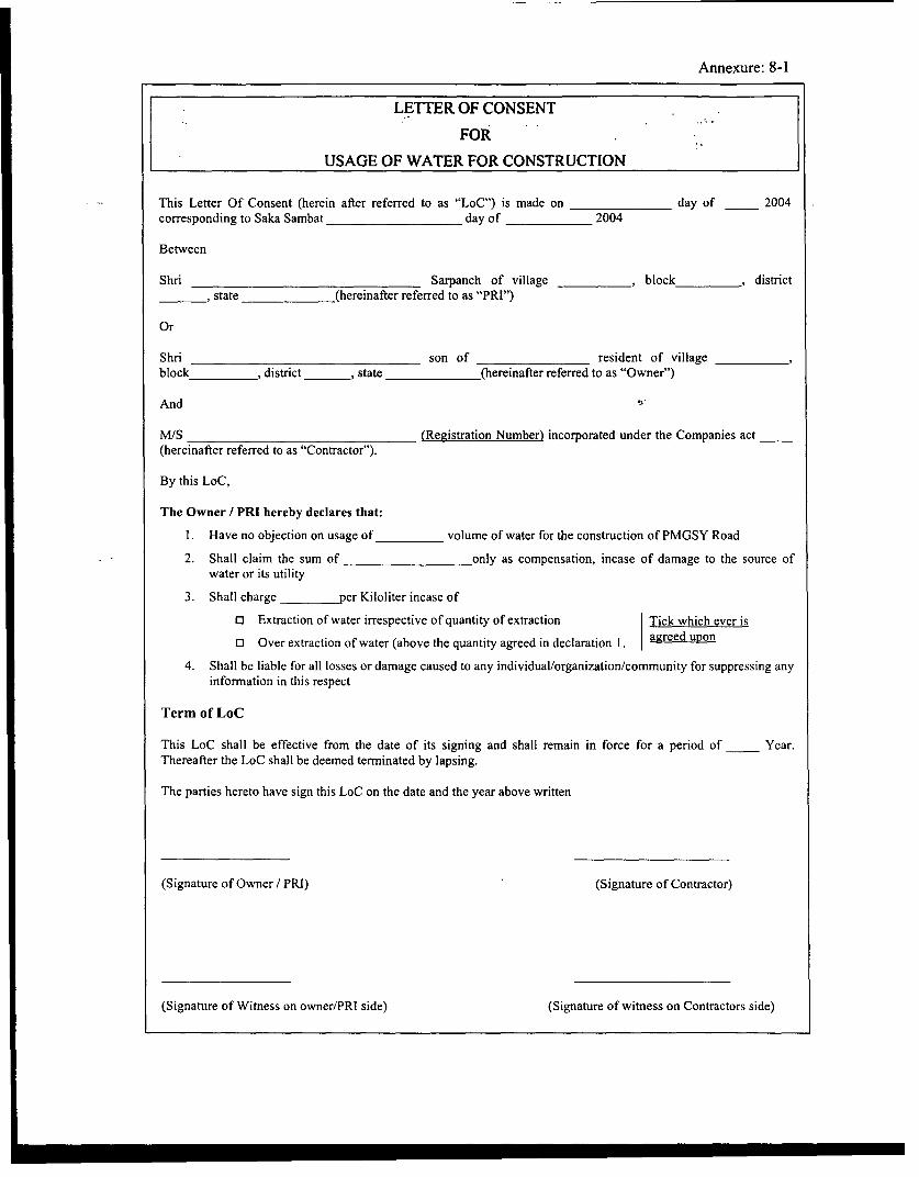
Annexure: 8-1
LETTER OF CONSENT
FOR
USAGE OF WATER FOR CONSTRUCTION
This Letter Of Consent (herein after referred to as "LoC") is made on day of 2004corresponding to Saka Sambat day of 2004
Between
Shri Sarpanch of village _ _ , block , district, state (hereinafter referred to as "PRI")
Or
Shri son of resident of villageblock ,district _ _, state (hereinafter referred to as "Owner")
And
M/S (Registration Number) incorporated under the Companies act(hereinafter referred to as "Contractor").
By this LoC,
The Owner / PRI hereby declares that:
1. Have no objection on usage of volume of water for the construction of PMGSY Road2. Shall claim the sum of only as compensation, incase of damage to the source of
water or its utility
3. Shall charge per Kiloliter incase of
o Extraction of water irrespective of quantity of extraction Tick which ever iso Over extraction of water (above the quantity agreed in declaration 1. agreed upon
4. Shall be liable for all losses or damage caused to any individual/organization/community for suppressing anyinformation in this respect
Term of LoC
This LoC shall be effective from the date of its signing and shall remain in force for a period of Year.Thereafter the LoC shall be deemed terminated by lapsing.
The parties hereto have sign this LoC on the date and the year above written
(Signature of Owner / PRI) (Signature of Contractor)
(Signature of Witness on owner/PRI side) (Signature of witness on Contractors side)

Annexure: 10-1
NO OBJECTION CERTIFICATE
FOR
DISPOSAL OF CONSTRUCTION WASTE
This No Objection Certificate (herein after referred to as "NOC") is made on day of 2004corresponding to Saka Sambat day of 2004
Between
Shri son of resident of villageblock , district , state (hereinafter referred to as "Owner")
And
M/S (Registration Number) incorporated under the Companies act(hereinafter referred to as "Contractor").
By this NOC,
The Owner hereby declares that:
1. Has transferable rights of acre of land bearing khasra No. in villageblock , tehsil , and district
2. Have no objection on temporary dumping of construction waste from PMGSY Road Construction within thesaid boundaries: (North Side) , (South Side) , (East Side) - (West Side)
3. Above said land shall only be utilized for the disposal of construction waste other than hazardous waste /material.
4. Shall claim the sum of only as compensation, incase reclamation of above said landnot being undertaken within _ _ (day / month / year) from the date of signing of NOC.
5. Shall be liable for all losses or damage caused to any individual/organization/community for suppressing anyinformation in this respect
The Contractor hereby commits that:
1. Not to carry out any activity beyond the specified boundary, as specified in the boundary above.
2. To reclaim the plot of land within (day / month / year) from the date of signing of NOC as perReclamation Plan approved by the PIU, (Name of the PIU).
3. Shall compensate above-mentioned sum to the owner incase above mention time frame is not met.
Term of MoU
This MoU shall be effective from the date of its signing and shall remain in force for a period of Year.Thereafter the MoU shall be deemed terminated by lapsing.
The parties hereto have sign this MoU on the date and the year above written
(Signature of Owner) (Signature of Contractor)

r I E Roadwvy Vldth 7. rM -i
PUN H >g t~~~~~~~~ ~~~~~~~~~~~.;0'., 200flONX WlC rp , , ON SIDE SLOP
IY1 SXCrlON A-A\ 20.n0ace Rough cubic tne_ of SO30mm7
-- h-u l ize hand pitched an th elope..Int.ertlcee filed up with epil nd .moilEnbvnkntQ Gram panted In the
SXCTION B-B
ROAD ON POND DMDANMIT
WATERBODY REHABILITATION MINISTRY OF RURAL DEVELOPMENT (MoRD)
PROJECT ANNE)QJRE DO.- S:- Ce.
NMA l D JLEA ASSOCIATES SOUTH ASIA PVT, LTD.PRADHAN MANTRI GRAMIN SADAK YOJANA 11-1 03-02-04 NOT TO SCALE 4 (LASA) NEW DELHI

Local available tree speciesplaced 2.5 m c / c \
z < 2 : ~I: I: I: Crc if-1porI I I I|\ ,
0~~~~~~~~~~~~~~~~~~~~
high) Road Land XXsTem,le
O~n *O LII 5g
Compound Wall (200 mm thick and 1.2 On the Edge ofhigh) Road LandWidth
Sample BoQ for Culture PropertyBuilt Up Area Sq m 9Plot Area Sq m 165
Sl No Item Unit Quantity
I Dressing Area Sq m 156
2 Brick Floor Sq m 40
3 Tree and Flower Plantation
4 Grass Area Sq m 52.5
5 No of trees No 1
6 Compound Wall
(1) Brick Work Cu m 8.775
(II) Excavation Cum 10.53
TITLE Cant
RELOCATION OF CULTURE PROPERTY MINISTRY OF RURAL DEVELOPMENT (MoRD)
PfIOJECT ANNEXURE .LEA ASSOCIATES SOUTH ASIA PV. LTD.PRADHAN MANTRI GRAMIN SADAK YOJANA 11 03-2-4 NOT TO SCALE (LASA) NEW DELHI
m -~~~~~~~~~~. LAA E EH

Annexure: 16-1
MEMORANDUM OF UNDERSTANDINGBetween
PUBLIC WORK DEPARTMENT (PWD), GOVERNMvENT OF (Mention State) .STATE FOREST DEPARTMENT
AndPANC[AYAT RAJ INSTITUTION (PRI)
This MEMORANDUM OF UNDERSTANDING (hereinafter referred to as "MoU" is made onthe _ day of (Month), (Year) for (Name of PMGSY Road) of length km.Between
Public Work Department (PWD), Government of (Mention State)State Forest Department
And
Panchayat Raj Institution (PRI)
By this MoU, PRI and State Forest Department agree to undertake roadside tree plantation alongthe PMGSY Road, in accordance to the commitments cited below:
STATE FOREST DEPARTMENT HERE BY COMMITS:
i. The alignment shall be finalized after transect walk in case it passes through Forest area.
ii. Forest Department agrees to depute forest ranger to provide suggestions to designmodification and to help in identification of species of trees to be felled if any. This shallhelp in drawing up tree plantation strategy. In case the alignment passes through forestareas, Forest Ranger shall provide information on presence of any rare/endangeredspecies as per the Red Data Book.
iii. To assist PIU for developing roadside tree plantation strategy on the PMGSY road inconsultation with the community.
iv. To supply saplings to the PRIs / Community from the forest nurseries.
v. To provide training to PRI / Community for:
a. Seeding procedure
b. Fertilizing and watering of trees
c. Maintaining of roadside tree that include (i) cutting/lopping branches and (ii)Weed cutting.
vi. To depute Forest Ranger to monitor the healthy survival of trees (refer Annexure I formonitoring format) and prepared monitoring report at every three months incorporatinggaps and suggestions. The copy of the same shall be sent to DFO and PIU.

Annexure: 16-1
PANCHAYAT RAJ INSTITUTION (PRI) HERE BY COMMITS:
i. To plant saplings provided by the state forest department as per roadside plantationstrategies.
ii. To undertake training program organized by the forest department for planting andmaintaining the trees.
iii. To undertake maintenance of planted trees with its own funds. The maintenance shallinclude:
a. Fertilizing and watering the trees during initial period of two to three years.
b. Spraying of insecticides / pesticides
c. Cutting/lopping branches up to a height of 2.5m above grouhd level to ensurevisibility.
d. Removal of dead wood from the roadway and storing away from roads, and
e. Weed cutting from shoulders and keeping the shoulders free from any growth ofvegetation
iv. To plant replacement saplings where the survival rate is less than 80 %
v. To prepare roadside tree plantation inventory for every kilometer length for PMGSYRoad including rate of survival after every three month. The copy of the same shall besubmitted to PIU.
This MoU shall be valid for a period of two year from the date of its signing and may be renewedas mutually agreed upon between PWD, PRIs and Forest Department.
The terms and conditions set out in this MoU shall supersede all earlier communication, if any,exchanges for the purpose.
Dated:
Signature:
Executive Engineer Sarpanch District Forest Officer
(PIJ) (PRI) (Forest Department)
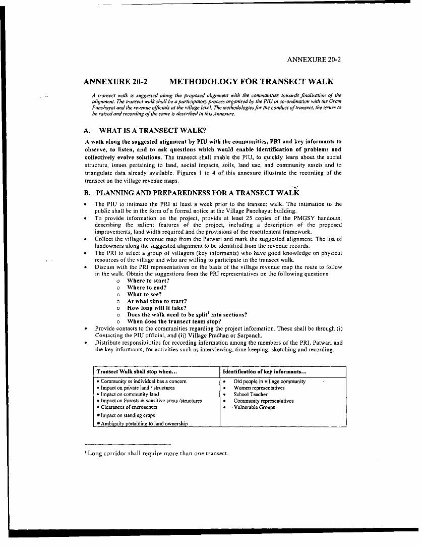
ANNEXURE 20-2
ANNEXURE 20-2 METHODOLOGY FOR TRANSECT WALKA transect walk is suggested along the proposed alignment with the communities towards finalisation of thealignment. The transect walk shall be a participatory process organised by the PIU in co-ordination with the GramPanchayat and the revenue officials at the village level. The methodologiesfor the conduct of transect, the issues tobe raised and recording of the same is described in this Annexure.
A. WHAT IS A TRANSECT WALK?A walk along the suggested alignment by PIU with the communities, PRI and key informants toobserve, to listen, and to ask questions which would enable identification of problems andcollectively evolve solutions. The transect shall enable the PIU, to quickly learn about the socialstructure, issues pertaining to land, social impacts, soils, land use, and community assets and totriangulate data already available. Figures I to 4 of this annexure illustrate the recording of thetransect on the village revenue maps.
B. PLANNING AND PREPAREDNESS FOR A TRANSECT WALK* The PIU to intimate the PRI at least a week prior to the transect walk. The intimation to thepublic shall be in the form of a formal notice at the Village Panchayat building.* To provide information on the project, provide at least 25 copies of the PMGSY handouts,
describing the salient features of the project, including a description of the proposedimprovements, land width required and the provisions of the resettlement framework.* Collect the village revenue map from the Patwari and mark the suggested alignment. The list oflandowners along the suggested alignment to be identified from the revenue records.* The PRI to select a group of villagers (key informants) who have good knowledge on physical
resources of the village and who are willing to participate in the transect walk.* Discuss with the PRI representatives on the basis of the village revenue map the route to follow
in the walk. Obtain the suggestions from the PRI representatives on the following questionso Where to start?o Where to end?o What to see?o At what time to start?O How long will it take?o Does the walk need to be split' into sections?O When does the transect team stop?
* Provide contacts to the communities regarding the project information. These shall be through (i)Contacting the PIU official, and (ii) Village Pradhan or Sarpanch.* Distribute responsibilities for recording information among the members of the PRI, Patwari andthe key informants, for activities such as interviewing, time keeping, sketching and recording.
Transect Walk shall stop when... Identification of key informants...* Community or individual has a concem * Old people in village community* Impact on private land / structures * Women representatives• Impact on community land * School Teacher* Impact on Forests & sensitive areas /structures * Community representatives* Clearances of encroachers * Vulnerable Groups* Impact on standing crops* Ambiguity pertaining to land ownership
Long corridor shall require more than one transect.

ANNEXURE 20-2
C. CONDUCTING A TRANSECT WALK* Based on the responsibilities assigned, the participants shall observe and record in detail all-
important things on the revenue map and get as much information as possible from the villagersand the locals. When talking to the villagers, the PIU to feel free to use the six helpers:
o When?o What?o How?o Where?O Why?O Who?
* Make notes of all vital information gathered and draw sketches wherever necessary. Thesensitive locations where additional efforts need to be taken during the design will be marked onthe revenue map.
* Travel slowly and patiently and try to understand the physical features and aspects related tosocial issues, land titles, in the village from different perspectives.
Social Aspects ... Environmeotal Aspects ... -
* Sites of additional land uptake * Trees* Encroachments and squatters * Forests if any* Land categories impacted * Drainage lines, rivers and water crossings* Lands with traditional, customary rights * Irrigation water courses* Population characteristics incl. vulnerable * Water bodies
groups * Grazing lands* Assessment of social impacts * Utilities
o Land * Community facilitieso Structures (Residential/Commercial) * Schoolso Other structures (Wells, Temples etc) * Hospitalso Trees, standing crops * Major junctions ando Common properties * Seasonal markets or culturalo Livelihood and economic opportunities congregations
* The PIU representative to communicate to the participants on site, on the possible extent ofimprovements. The PIU shall provide adequate responses to the communities on:
o Queries raised pertaining to environmental and social issueso Process of voluntary land donation.o Working out possible alignment changes to minimise impactso Compliance to IRC SP-20 standards to enhance safety of road users.
* All queries and concerns of the communities shall be recorded.
D. THINGS TO DO AFTER THE TRANSECT WALK* After the completion of a transect walk, sit down in a suitable place with the villagers to have a
discussion and recording of information and data collected.* Prepare an illustrative diagram of the transect walk on the revenue map using the information
already gathered and get the information cross-checked by the community.* Prior to dispersing for the day, finalize a date for the formal consultation session to be
conducted.

t< ut s % -o-41r*> j -
.-~~~~ 14~~
Ar.
4,.'.
* Marking centerline of the proposed alignment on the revenue map * Inventory of envir-onmental and physical features along the alignment* Assessment of available land width * Marking of land uses* Identification of land categonies and ownership status

Ei~~~~~4 -- VO ., .i.a
water crossings, fDrests, locations with large number of trees. I* Identification of vulnerable persons

ANNEXURE 20-3
FORMAT FOR RECORDING CONSULTATION
District Village
Road No Date
Road Name Time
Venue Duration
1. Project Description
2. Issues raised by the community and responses provided
Issues:
Response by PIU/PRI:
3. Key issues
(i)
(ii)
(iii)
4. Conclusion by PRI representatives

ANNEXURE 20-3
Suggested Content of Consultation sessions... ; - ;.
The meeting duration shall be for about 1-1/2 to 2 hours and shall cover the following.
All these steps of the consultation shall be recorded in the format
I: The session shall start with a description of the project by the PIU officials to thecommunity. The following information shall be covered:
Overview of PMGSY and criteria for selection
Involvement of PRIs & communities in project planning, design and implementationExpectations of the project from the beneficiaries, the communities
Outputs of the transect and how the concerns of the communities have been incorporatedinto the design, if not, why they have not been incorporated
Provisions of the project as the Resettlement Framework provisions, mechanisms forvoluntary land donation process etc
Environmental issues in the project, Codes of practice
Census survey
Mechanisms for Grievances, implementation arrangements
Involvement of communities / PRI in tree plantation, managing induced development etcLikely construction schedule
II After the description of the project, suggestions from the community on the projectand issues will be obtained.
III: Responses to the issues raised will be provided by the PIU, PRI during themeeting. For issues that require a visit to the site or involves certain engineering decisions, orconsultations with other Government agencies, a date shall be committed for response to thesame. The response shall be given by the PIU to the PRI within the specified date.
IV: The PIU shall summarize the issues.
V: Conclusion by the PRI representatives and attendance of the participants.
On a separate sheet mark the attendance at the meeting in the following formatCommunity PIU/PRI
Name of Person Signature Name and Signatureand village of designation of
residence Official

References
1. Rural Road Manual, IRC: SP: 20-2002, Indian Road Congress (IRC) Publications, 2002
2. Hill Road Manual, IRC: SP: 48-1998, Indian Road Congress (IRC) Publications, 1998
3. Keller, G.; Sherar J.; Best Management Practice Field Guide, Low-Volume RoadsEngineering, US Agency for International Development (USAID), Washington, DC. May,2003.
4. General Conditions of Contract for Central P.W.D. Works, A Government of IndiaPublication, 2003
5. Utilization of Fly Ash, Ministry of Environmental and Forest (MoEF) Notification, S.O.1164 (E), The Gazette of India, Extraordinary Part II, Section 3, Sub-section (ii), Ministry ofEnvironment and Forest, 5.h November, 2002.
6. Steel Slag, Turner-FairBank Highway Research Center (online). [Cited 24 'h September 2003]Available from World Wide Web: http://www.tfhrc.gov/hnr20/recycle/waste/ssa2.htm.
7. Siddharth, P., Gainful Utilization of Marble Waste, An Effort towards protection of Ecology& Environment (Online), [Cited 25'" September 2003] Available from World Wide Web:http://www.cdos-india.com/papers/ 18%20-%2CGainful%2OUtilization%20of%/o2OMarble%2OWast%2/0-%20Siddharth%2QPareek.doc
8. Recommended Practice for Borrow Pits for Road Embankment Constructed by ManualOperation, IRC: 10-1961, Indian Road Congress (IRC) Publication, 1961
9. Permanent Vegetation, CODE 880, Illinois Urban ManualPractice Standard, (online), [Cited on 1 0 ,h October 2003], Available from World Wide Web:http://www.il.nrcs.usda.gov/engineer/urban/Standards/urbst880.htm
10. Chilibeck, B., Chislett, G., Norris G., Land Development Guideline for the Protection ofAquatic Habitat, The Habitat Management Division of Fisheries and Ocean and TheIntegrated Branch of The Ministry of Environment, Land and Parks, Government of Canada,September 1993.(Online), [Cited on 19 th September 2003], Available from the WorldwideWeb: http://collection.nlc-bnc.ca/ 100/200/301/dfo-mpo/land development guidelines/165353.pdf.
11. Water, Clause 1010, Materials for Structures, Section 1000, Specification for Road and BridgeWorks (Fourth Revision), Ministry of Road Transport and Highways, Indian Road Congress(IRC) Publications, 2001.
12. Code of Practice for Plain and Reinforced Concrete (Fourth Revision), IS: 456-2000, IndianStandards, 2000.
13. Drinking Water (First Revision) (Amendment 1), Reaffirmed 1993, IS: 10500-1991, IndianStandards, 1993.
V

14. Construction/Demolition Waste Recycling and Disposal, Saskatchewan Environment,
Environmental Protection Branch, SWANA Publication #GR-REC 300, 1993, Senes
Consultants Ltd., Environment Canada, December 1993 (Online) [Cited on 21' September
2003], Available on Worldwide Web: http://www.se.gov.sk.ca
15. Guidelines for The Design of Small Bridges and Culverts, IRC: SP: 13-1973, Indian Road
Congress IRC) Publication, 1973.
16. Guidelines on Supplemental Measures for Design, Detailing & Durability of Important
Bridge Structures, IRC: SP: 33-1989, Indian Road Congress (IRC) Publication, 1973.
17. Recommended Practice for Sight Distance on Rural Highways, IRC: 66-1976, Indian Road
Congress (IRC) Publication, 1976.
18. Manual on Landscaping of Roads, IRC: SP: 21-1979, Indian Road Congress (IRC) Publication,
1979
19. Role of Gram Panchayats in Regulating Development along Roads, Post 73rd Constitutional
Amendment, 1992, Constitution of India.
VI