government of uttarakhand - ministry of ... d - nhidcl.pdfgovernment of uttarakhand for bhagirathi...
TRANSCRIPT

00[Type text] [Type text] [Type text][Type text][Type text] [Type text]
FEBRUARY - 2016
NATIONAL HIGHWAYS & INFRASTRUCTURE
DEVELOPMENT CORPORATION (NHIDCL)
ZONAL MASTER PLAN
DHARASHU – GANGOTRI ROAD NH-34 [OLD NH-108]
GOVERNMENT OF UTTARAKHAND
FOR BHAGIRATHI RIVER ECO-SENSITIVE ZONE
GOMUKH TO UTTARKASHI
i
TABLE OF CONTENTS
1.0 The Project Road............................................................................................................. 1
2.0 MoEF notification for eco-sensitive zone ....................................................................... 1
2.1 Construction of road more than 5km length in eco-sensitive zone. ................................ 2
2.2 Provision in the design of the road for the treatment of hill roads. ................................ 2
2.3 Use of debris in the construction of road and provision for disposal of unused debris .. 5
2.4 Provision of road side drains, alignment of road, mass balancing of
cut and fill. ...................................................................................................................... 8
2.5 Fault zone and land slide zones. ..................................................................................... 9
2.5.1 Major landslide locations .................................................................................... 9
2.6 Summary of provisions made in design of project road to meet the guidelines of
notification on eco –sensitive zone ............................................................................... 11
2.6.1 Benefits of the project ....................................................................................... 11
2.6.2 Cost benefits ratio ............................................................................................. 11
2.7 Other project road details .............................................................................................. 14
2.7.1 Project roads in buffer zone of Gangotri National Park ................................... 14
2.7.2 Socio-economic character along the road ......................................................... 14
2.7.3 Enginnering surveys, investigations and analysis ............................................. 15
2.7.4 Existing road details .......................................................................................... 15
2.7.5 Traffic ............................................................................................................... 16
2.7.6 Design chainage system .................................................................................... 16
2.7.7 Improvement proposal and design .................................................................... 17
2.7.8 Cross sectional arrangement ............................................................................. 20
2.7.9 Structure improvements .................................................................................... 21
2.7.10 Proposed protection works ................................................................................ 21
2.7.11 Pavement design ............................................................................................... 22
2.7.12 Preliminary project cost .................................................................................... 22
2.7.13 Economic & financial viability ......................................................................... 23

1
ZONAL MASTER PLAN [DHARASHU-GANGOTRI ROAD NH-34 (OLD NH-108)]
1.0 THE PROJECT ROAD
Project Road NH 108, starts from Dharasu bend (km 0.00) i.e. at the junction with NH 94
and ends at Gangotri (km 124.00). But presently as per new numbering of National
Highway, NH 108 has been renamed as National Highway 34 which originates from
Gangotri. Existing km stones also renamed as NH 34, chainage started from Gangotri
(km 0) and continued towards Dharasu.
For project preparation chainage is considered as per existing stones of NH 34, i.e
km 0.0 at Gangotri and proceeding towards Dharasu. The project road entirely
comes under Uttarkashi district.
Project road passes through Built-up area Gangotri, Harsil, Gangnani, Bhatwari, Maneri,
Netala, Gangori, Uttarkashi, Matli , Dunda and finally end at Dharasu. The project road
mainly follows Bhagirathi river from start to end. The project Road key plan is given
under Fig. 1
Fig.1: Project Road Key Plan
2.0 MOEF NOTIFICATION FOR ECO-SENSITIVE ZONE
Ministry of Environment and Forest, Notification, dated 18/12/2012 notifies entire
watershed of about 100 km stretch of the river Bhagirathi from Gaumukh to
Uttarkashi covering an area of 4179.59 sq.km as Eco-sensitive Zone. Accordingly a
Master Plan shall be prepared for the proposed development within Eco-sensitive zone
and to be presented to Monitoring Committee. As part of master plan, proposal for
Dharasu – Gangotri Road project is prepared.
2
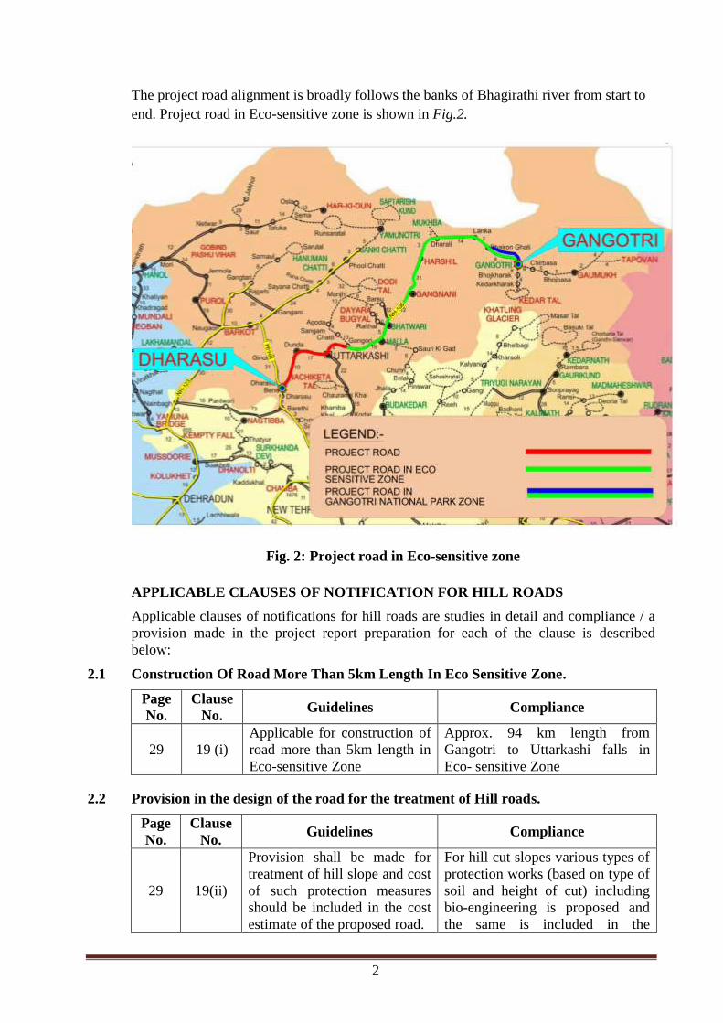
The project road alignment is broadly follows the banks of Bhagirathi river from start to
end. Project road in Eco-sensitive zone is shown in Fig.2.
Fig. 2: Project road in Eco-sensitive zone
APPLICABLE CLAUSES OF NOTIFICATION FOR HILL ROADS
Applicable clauses of notifications for hill roads are studies in detail and compliance / a
provision made in the project report preparation for each of the clause is described
below:
2.1 Construction Of Road More Than 5km Length In Eco Sensitive Zone.
Page
No.
Clause
No. Guidelines Compliance
29 19 (i)
Applicable for construction of
road more than 5km length in
Eco-sensitive Zone
Approx. 94 km length from
Gangotri to Uttarkashi falls in
Eco- sensitive Zone
2.2 Provision in the design of the road for the treatment of Hill roads.
Page
No.
Clause
No. Guidelines Compliance
29 19(ii)
Provision shall be made for
treatment of hill slope and cost
of such protection measures
should be included in the cost
estimate of the proposed road.
For hill cut slopes various types of
protection works (based on type of
soil and height of cut) including
bio-engineering is proposed and
the same is included in the
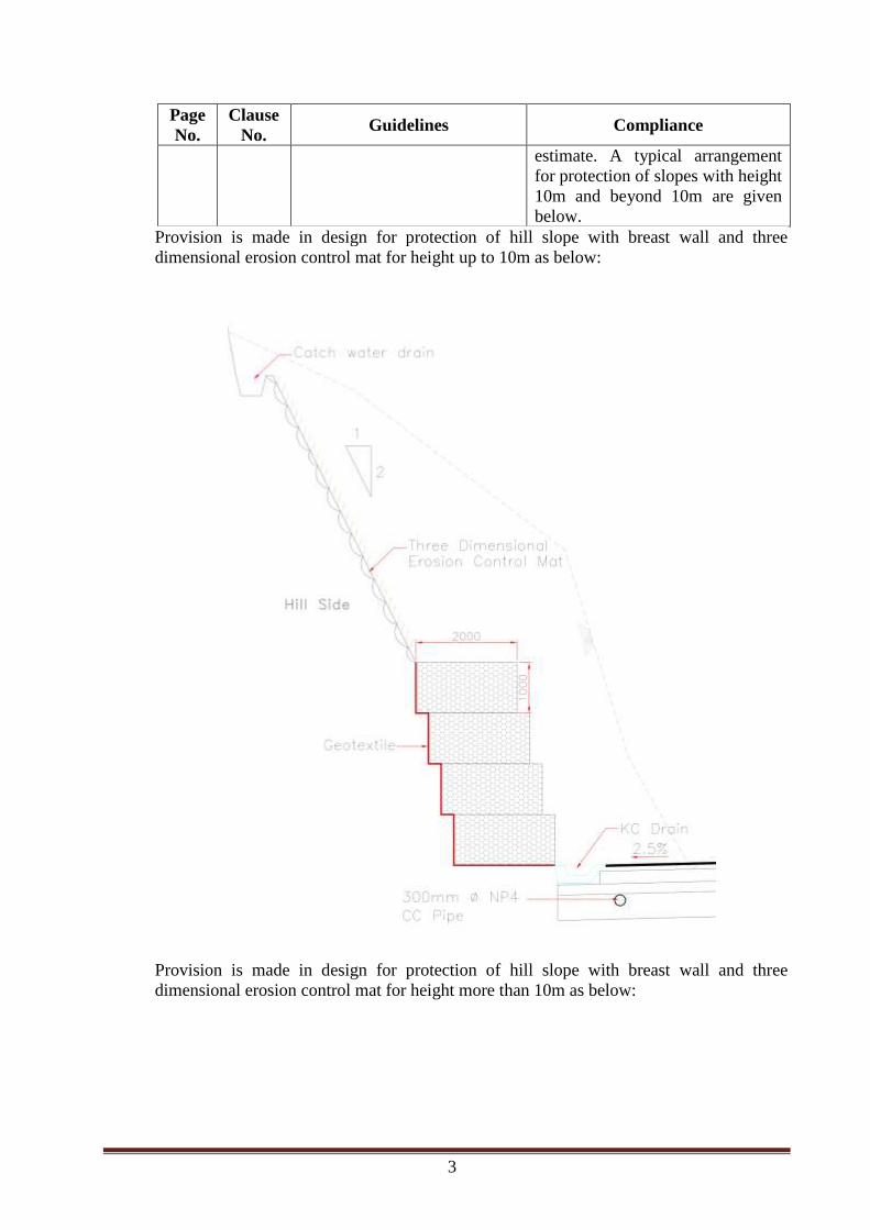
3
Page
No.
Clause
No. Guidelines Compliance
estimate. A typical arrangement
for protection of slopes with height
10m and beyond 10m are given
below.
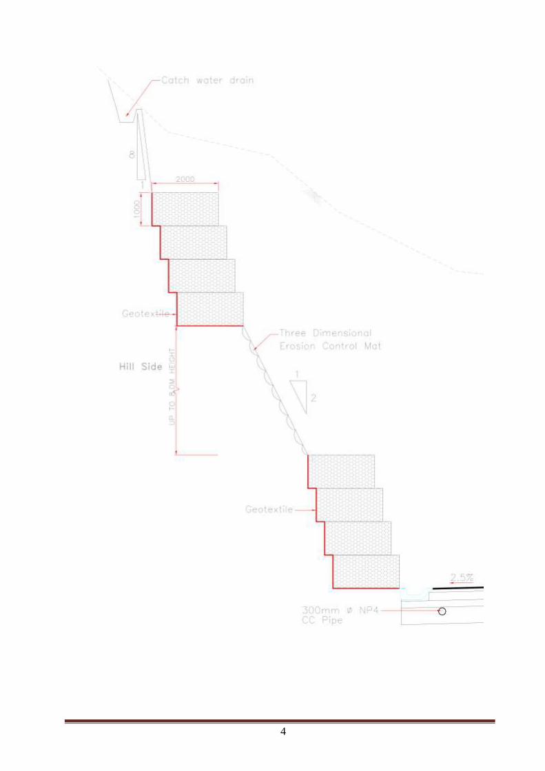
Provision is made in design for protection of hill slope with breast wall and three
dimensional erosion control mat for height up to 10m as below:
Provision is made in design for protection of hill slope with breast wall and three
dimensional erosion control mat for height more than 10m as below:
4
5
2.3 Use of debris in the construction of road and provision for disposal of unused debris
Page
No.
Clause
No. Guidelines Compliance
19 (iii)
The debris shall be
subsumed in the road
construction and
provision shall be
made for disposal of
unused debris.
Hard rock obtained from road cutting shall
be reused for construction of retaining wall,
breast wall and crushing aggregate (if
suitable) shall be used for road and bridge
works.
Soil and soft rock obtained from road
cutting shall be reused in filling portion of
project road.
For disposal of surplus material, 26 no. of
dumping zone have been identified along
the project highway by making joint site
visit with forest officials.
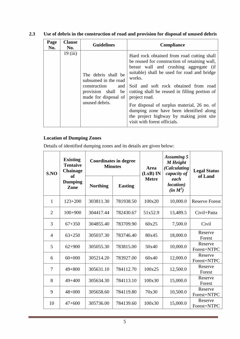
Location of Dumping Zones
Details of identified dumping zones and its details are given below:
S.NO
Existing
Tentaive
Chainage
of
Dumping
Zone
Coordinates in degree
Minutes Area
(LxB) IN
Metre
Assuming 5
M Height
(Calculating
capacity of
each
location)
(in M3)
Legal Status
of Land
Northing Easting
1 123+200 303811.30 781938.50 100x20 10,000.0 Reserve Forest
2 100+900 304417.44 782430.67 51x52.9 13,489.5 Civil+Patta
3 67+350 304855.40 783709.90 60x25 7,500.0 Civil
4 63+250 305037.30 783746.40 80x45 18,000.0 Reserve
Forest
5 62+900 305055.30 783815.00 50x40 10,000.0 Reserve
Forest+NTPC
6 60+000 305214.20 783927.00 60x40 12,000.0 Reserve
Forest+NTPC
7 49+800 305631.10 784112.70 100x25 12,500.0 Reserve
Forest
8 49+400 305634.30 784113.10 100x30 15,000.0 Reserve
Forest
9 48+000 305658.60 784119.80 70x30 10,500.0 Reserve
Forest+NTPC
10 47+600 305736.00 784139.60 100x30 15,000.0 Reserve
Forest+NTPC

6
S.NO
Existing
Tentaive
Chainage
of
Dumping
Zone
Coordinates in degree
Minutes Area
(LxB) IN
Metre
Assuming 5
M Height
(Calculating
capacity of
each
location)
(in M3)
Legal Status
of Land
Northing Easting
11 46+800 305748.10 784148.10 Lx6x10 300.0 NTPC Tunnel
12 47+000 305818.9 784149.7 100x50 25000 NTPC
13 45+500 305838.7 784147.6 60X50 15000 Reserve
Forest
14 44+500 305908.5 784158.7 100X50 25000 Reserve
Forest+NTPC
15 30+000 310059.8 784248.9 60X40 12000 Reserve
Forest
16 29+000 310112.1 784249.2 300X80 120000 Reserve
Forest
17 28+000 310149.4 78436.1 200X50 50000 Reserve
Forest
18 27+000 31020.8 784324 200X50 50000 Reserve
Forest
19 27+000 310205 784330.9 100X50 25000 Reserve
Forest
20 21+000 310159.9 784521.5 50x150 37500 Reserve
Forest
21 19+000 310223.2 784741.8
50x50 12500 Reserve
Forest 50x50 12500
22 17+000 310239.8 784851.9 100x100 50000 Reserve
Forest
23 15+000 310237.4 785001.6 50x50 12500 Reserve
Forest
24 13+000 310238.1 785025.8 2 Hact 100000 Reserve
Forest
25 12+000 310217 785112.2 80x30 12000 Reserve
Forest
26 11+000 310213.6 785118.7 50x50 12500 Reserve
Forest
7
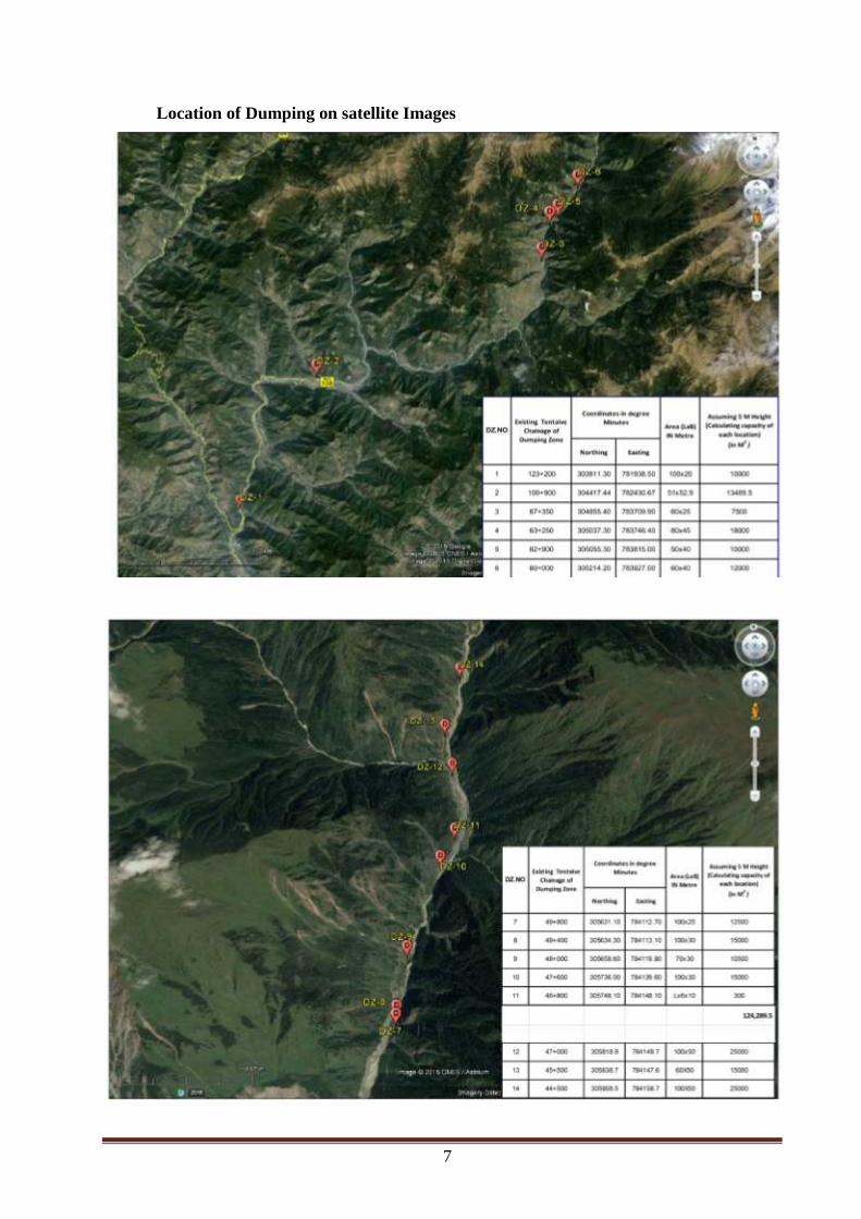
Location of Dumping on satellite Images

8
2.4 Provision of Road Side Drains, Alignment of Road, mass balancing of cut and fill.
Page
No.
Clause
No. Guidelines Compliance
30 19(iv)
All roads shall be
provided with road
side drains and
shall be connected
with the natural
drainage system.
Keeping in view of efficient drainage Kerb
& Channel drain has been proposed along
hill side drains which shall be connected to
adjoining culverts. In addition to existing
culverts, 104 no. of new culverts has been
proposed. Also catch water drains have
been proposed on top of cut section to avoid
flow of water through the cut slopes.
19(v)
Alignment shall be
selected so as to
minimize loss of
vegetal cover.
This issue is addressed by utilisation of
existing formation width to the maximum
possible extent. At constrained locations
formation width of 10 m with safety
provision has been proposed instead of
12m.
19(vi)
Appropriate design
standards shall be
followed balancing
cut and fill avoiding
unnecessary cut.
Existing road is passing along banks of
Bhagirathi river with one side river and one
side hill.
The option available to widen the road is by
cutting the hill with best utilisation of

9
Page
No.
Clause
No. Guidelines Compliance
existing formation width. Therefore surplus
material from hill cut is more than the earth
required for filling.
However attempts are made to utilise the
cut materials wherever feasible like use of
hard rock for construction of retaining wall,
breast wall, concrete and surplus material
shall be dumped at pre-defined dumping
zones
2.5 Fault zone and land slide zones.
Page
No.
Clause
No. Guidelines Compliance
19 (vii) Fault zone and land
slide zone shall be
given.
Detailed geological study of the project
road has been carried out and special
protection work is proposed for major land
slide locations as detailed here below.
2.5.1 Major Landslide Locations
Sl.No. Location
Existing
Chainage of
NH 34
Remarks
1 Sukhi Top – 4 Nos 37 - 42 These slides are bypassed under Sukhi
Top Realignment section
2 Gangnani 55 - 56
3 Bhatwari 67 - 68
4 Malla 72 - 74
5 Bishanpur 78 - 79
6 Laldang 79 - 80
7 Netala 87 - 88
These slides are bypassed under Netala
and Garampani realignment section 8 Ganeshpur 90 - 91
9 Garampani 92 - 93
10 Bareti 100 - 101
11 Nalupani 123 - 124
10
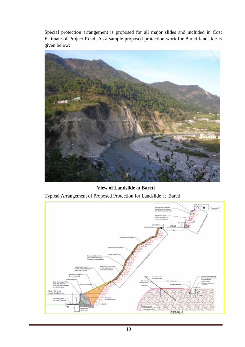
Special protection arrangement is proposed for all major slides and included in Cost
Estimate of Project Road. As a sample proposed protection work for Bareti landslide is
given below:
View of Landslide at Bareti
Typical Arrangement of Proposed Protection for Landslide at Bareti
11
Page
No.
Clause
No. Guidelines Compliance
33 3 (b) (vii)
Defense installation
and any other
infrastructure
development related to
National security.
This project is in the category of
“Regulated activities in the Eco-
sensitive zone”. The project highway
has strategic importance being major
connectivity to the Indo-China Border.
2.6 Summary of Provisions Made in Design of Project Road to meet the Guidelines of
Notification on Eco –Sensitive Zone
Hill cut slopes prone to slide (other than rock strata) are protected by Breast Wall
and three dimensional erosion control mate.
Special type of protection work is made for major landslide locations.
Catch water drain is proposed on top of cut portion to avoid flow of water in cut
surface.
K C drain is proposed on hill side of road for proper drainage.
Drains are connected to natural streams and culverts.
Provision is made for utilization of cut materials to the extent possible.
For disposal of surplus earth, Dumping Zones are already identified throughout the
project road along with official of Forest Department.
For pedestrians footpath is proposed in built-up stretches.
Utility ducts with chambers are provided to avoid unnecessary excavation by
various agencies.
Cost of all proposed items are included in the Cost Estimate of Project Road.
Proposal for Wildlife Clearance of Gangotri National Park already submitted
2.6.1 Benefits of the project
Following benefits are envisaged from the project:
Reduction in travel time
Reduction in Vehicle Operation Cost
Enhanced Safety
Reduction in pollution
Increase in Tourism activities
2.6.2 Cost Benefits Ratio
The cost benefit analysis is has been carried out within the broad framework of social
cost-benefit. This will provide more affordable public transportation. The housing in
transit-oriented neighbourhoods improves accessibility for lower-income households.
Based on project cost and above benefits cost benefit ratio has been worked out summary
of the same is given below:
12
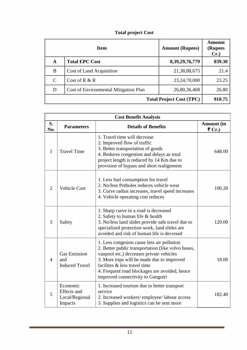
Total project Cost
Item Amount (Rupees)
Amount
(Rupees
Cr.)
A Total EPC Cost 8,39,29,76,779 839.30
B Cost of Land Acquisition 21,38,88,675 21.4
C Cost of R & R 23,24,70,000 23.25
D Cost of Environmental Mitigation Plan 26,80,36,468 26.80
Total Project Cost (TPC) 910.75
Cost Benefit Analysis
S.
No. Parameters Details of Benefits
Amount (in
₹ Cr.)
1 Travel Time
1. Travel time will decrease
2. Improved flow of traffic
3. Better transportation of goods
4. Reduces congestion and delays as total
project length is reduced by 14 Km due to
provision of bypass and short realignment
648.00
2 Vehicle Cost
1. Less fuel consumption for travel
2. No/less Potholes reduces vehicle wear
3. Curve radius increases, travel speed increases
4. Vehicle operating cost reduces
100.20
3 Safety
1. Sharp curve in a road is decreased
2. Safety to human life & health
3. No/less land slides provide safe travel due to
specialized protection work, land slides are
avoided and risk of human life is decresed
120.00
4
Gas Emission
and
Induced Travel
1. Less congesion cause less air pollution
2. Better public transportation (like volvo buses,
vanpool etc.) decreases private vehicles
3. More trips will be made due to improved
facilites & less travel time
4. Frequent road blockages are avoided, hence
improved connectivity to Gangotri
18.00
5
Economic
Effects and
Local/Regional
Impacts
1. Increased tourism due to better transport
service
2. Increased workers/ employee/ labour access
3. Supplies and logistics can be sent more
182.40

13
Cost Benefit Analysis
S.
No. Parameters Details of Benefits
Amount (in
₹ Cr.)
efficiently and effectively
4. Efective mobility/ transportation facilities
helps in developing more trade
5. Due to bypass provision, more villages are
connected by road
6. Significantly enhances the visual effects of
the locations
Total Cost Benefit 1068.60
B.C. Ratio 1.17

14
2.7 OTHER PROJECT ROAD DETAILS
2.7.1 PROJECT ROAD IN BUFFER ZONE OF GANGOTRI NATIONAL PARK
A section of the project road from Gangotri (km 0.00) to Uttarkashi (Km 94.0) is falling
in Eco-sensitive zone.
A section of the project road from Gangotri (km 0.0) to Bhairoghati (km 9.0) is in buffer
zone of Gangotri National Park situated at Gangotri
The project road near Gangotri is traversing at distance of 200 m from buffer zone of
Gangotri National Park. The Gangotri National Park (Latitude 78°45’ to 79°02’ East and
Longitude 30°50’ to 31°12’ North) is located in the upper catchment of Bhagirathi river
near Gangotri. Project road in in buffer zone of Gangotri National Park is shown in Fig.3
Fig. 3: Project Road from Gangotri – Bhairoghati (9.0 km) is in buffer zone of
Gangotri National Park
Proposal for Wildlife Clearance already prepared and uploaded online in MoEF
official Website.
2.7.2 SOCIO-ECONOMIC CHARACTER ALONG THE ROAD
The preliminary assessment of land use pattern along the project corridor is presented in
Table below. This indicates that the distribution of length of Project road and percentage
Length in terms of land use and roadside environments:
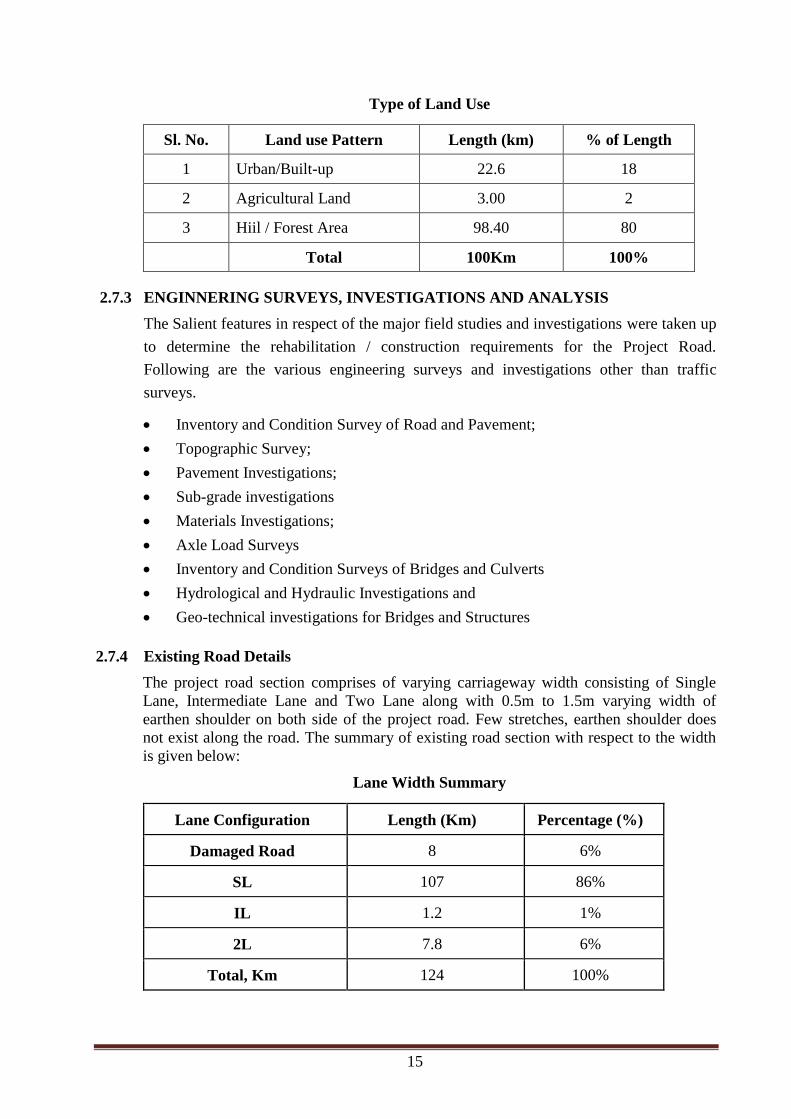
15
Type of Land Use
Sl. No. Land use Pattern Length (km) % of Length
1 Urban/Built-up 22.6 18
2 Agricultural Land 3.00 2
3 Hiil / Forest Area 98.40 80
Total 100Km 100%
2.7.3 ENGINNERING SURVEYS, INVESTIGATIONS AND ANALYSIS
The Salient features in respect of the major field studies and investigations were taken up
to determine the rehabilitation / construction requirements for the Project Road.
Following are the various engineering surveys and investigations other than traffic
surveys.
Inventory and Condition Survey of Road and Pavement;
Topographic Survey;
Pavement Investigations;
Sub-grade investigations
Materials Investigations;
Axle Load Surveys
Inventory and Condition Surveys of Bridges and Culverts
Hydrological and Hydraulic Investigations and
Geo-technical investigations for Bridges and Structures
2.7.4 Existing Road Details
The project road section comprises of varying carriageway width consisting of Single
Lane, Intermediate Lane and Two Lane along with 0.5m to 1.5m varying width of
earthen shoulder on both side of the project road. Few stretches, earthen shoulder does
not exist along the road. The summary of existing road section with respect to the width
is given below:
Lane Width Summary
Lane Configuration Length (Km) Percentage (%)
Damaged Road 8 6%
SL 107 86%
IL 1.2 1%
2L 7.8 6%
Total, Km 124 100%

16
2.7.5 TRAFFIC
Traffic in terms of PCU on project highway section of the NH-108 / NH-34 at the base
year 2013-14 at km 114 and km 91+000 of NH-34 is 1546 and 829 PCUs respectively for
all vehicles including tolled, Non-tolled & Exempted vehicles. The forecasted traffic in
terms of PCU is presented in table below.
Projected traffic at constant 5% annual growth rate is given below:
Traffic Projection
As per Calculated Growth
Rate Assuming 5% Growth Rate
Compositio
n/ Remarks Year
km 9.8 km
91.0 Average km 114 km 91 Average
1546 829 1188 1546 829 1188 Base Year Year 2014-15
2002 1097 1549 1973 1059 1516 Year 5 Year 2019-20
2496 1395 1946 2519 1351 1935 Year 10 Year 2024-25
3073 1751 2412 3215 1724 2469 Year 15 Year 2029-30
3792 2199 2996 4103 2201 3152 Year 20 Year 2034-35
5813 3481 4647 6683 3585 5134 Year 30 Year 2044-45
As per para 3 of MoRTH circular No. NH-14019/6/2012-P&M, dated 05/10/2012 and as
desired by NHIDCL proposed configuration of the project road is two lanes with paved
shoulders.
2.7.6 Design Chainage System
As per new NH chainge system, design chainge system is started from Gangotri end and
preceded towards Dharasu. There are two major realignments proposed at Sukhi Top and
Netala & Garampani. Based on the realignment project road is divided in 5 sections. The
section details are given below along with respective existing chainage.
Details of Project Road Sections
Section
# From To
Existing
Chainage
(NH 34)
Design Chainage
(km) Design
Length
(km) From To From To
I Gangotri Start of Sukhi
top bypass 0.00 29.30 0.00 28.60 28.60
II Sukhi top Realignment 29.30 43.0 28.60 31.84 3.24
III
End of
Sukhi top
bypass
Start of
Netala bypass 43.0 86.4
31.82
(Break in
chainage-
20m
difference)
73.73 41.91

17
Section
# From To
Existing
Chainage
(NH 34)
Design Chainage
(km) Design
Length
(km) From To From To
IV Netala & Garampani
Realignment 86.4 94.0 73.73 81.80 8.07
V
End of
Netala
bypass
Dharasu bend 94.0 124.0 81.80 110.31 28.51
Total 110.33
Graphical representation of the project road sections is given below:
2.7.7 IMPROVEMENT PROPOSAL AND DESIGN
In addition to detailed reconnaissance, Consultant met officials of Border road
Organization (BRO) and took information’s regarding various problems encountered in
the project road stretch and their suggestions are noted carefully for further study.
Alignment improvements are classified under two categories as under:
Major Realignments
Geometric Improvements
Major realignments are proposed at the following locations

18
Proposed Major Realignments
Sl.
No.
Location
Exiting
length
realigned
(km)
Length of
Proposed
Realignme
nt (km)
Name of
village
Remarks / necessity for
realignment
Existing
Chainage
as per NH
34
Existing
Chainage as
per NH 108
From To From To
1 29.5 42.5 81.5 94.5 13.0 3.4 Sukhi
Top
Poor geometrics with
hairpin bends, steep
gradient and existing
alignment gradient
ascending to peak point
(Sukki top) and
descending again.
2 86.0 94.4 29.6 38 8.4 7.6
Nethala
and
Garamp
ani
Major land slide at
Nethala and existing
road at Garampani
completely washed
away during 2013
disaster.
21.4 Total
SUKKI TOP REALIGNMENT
Necessary for realignment at Sukki top
Poor horizontal geometry with sub-standard hairpin bends & sharp curves.
Landslides at stream crossings
Major bridge (Jhala bridge) at km 29+800 is in poor condition and require
reconstruction.
Realignment length is 10 km shorter than existing road
19
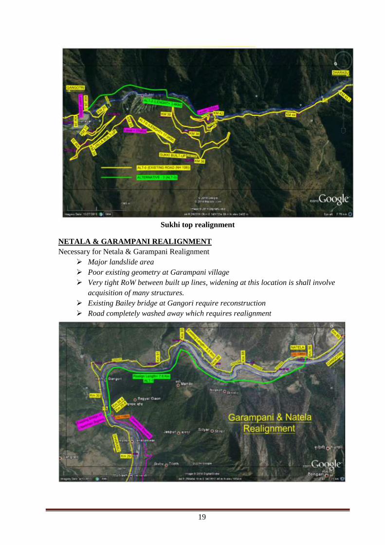
Sukhi top realignment
NETALA & GARAMPANI REALIGNMENT
Necessary for Netala & Garampani Realignment
Major landslide area
Poor existing geometry at Garampani village
Very tight RoW between built up lines, widening at this location is shall involve
acquisition of many structures.
Existing Bailey bridge at Gangori require reconstruction
Road completely washed away which requires realignment
20
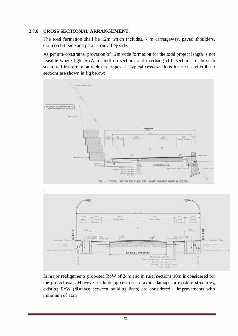
2.7.8 CROSS SECTIONAL ARRANGEMENT
The road formation shall be 12m which includes, 7 m carriageway, paved shoulders,
drain on hill side and parapet on valley side.
As per site constrains, provision of 12m wide formation for the total project length is not
feasible where tight RoW in built up sections and overhang cliff section etc. In such
sections 10m formation width is proposed. Typical cross sections for rural and built up
sections are shown in fig below:
.
In major realignments proposed RoW of 24m and in rural sections 18m is considered for
the project road. However in built up sections to avoid damage to existing structures,
existing RoW (distance between building lines) are considered improvements with
minimum of 10m
21
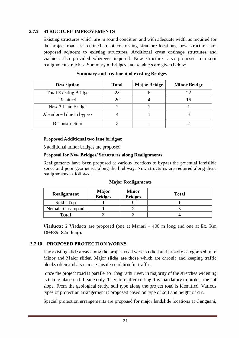
2.7.9 STRUCTURE IMPROVEMENTS
Existing structures which are in sound condition and with adequate width as required for
the project road are retained. In other existing structure locations, new structures are
proposed adjacent to existing structures. Additional cross drainage structures and
viaducts also provided wherever required. New structures also proposed in major
realignment stretches. Summary of bridges and viaducts are given below:
Summary and treatment of existing Bridges
Description Total Major Bridge Minor Bridge
Total Existing Bridge 28 6 22
Retained 20 4 16
New 2 Lane Bridge 2 1 1
Abandoned due to bypass 4 1 3
Reconstruction 2 - 2
Proposed Additional two lane bridges:
3 additional minor bridges are proposed.
Proposal for New Bridges/ Structures along Realignments
Realignments have been proposed at various locations to bypass the potential landslide
zones and poor geometrics along the highway. New structures are required along these
realignments as follows.
Major Realignments
Realignment Major
Bridges
Minor
Bridges Total
Sukhi Top 1 0 1
Nethala-Garampani 1 2 3
Total 2 2 4
Viaducts: 2 Viaducts are proposed (one at Maneri – 400 m long and one at Ex. Km
18+685- 82m long).
2.7.10 PROPOSED PROTECTION WORKS
The existing slide areas along the project road were studied and broadly categorised in to
Minor and Major slides. Major slides are those which are chronic and keeping traffic
blocks often and also create unsafe condition for traffic.
Since the project road is parallel to Bhagirathi river, in majority of the stretches widening
is taking place on hill side only. Therefore after cutting it is mandatory to protect the cut
slope. From the geological study, soil type along the project road is identified. Various
types of protection arrangement is proposed based on type of soil and height of cut.
Special protection arrangements are proposed for major landslide locations at Gangnani,
22
Bhatwari, Malla, Bishanpur, Laldang, Bareti and Nalupani as mentioned above.
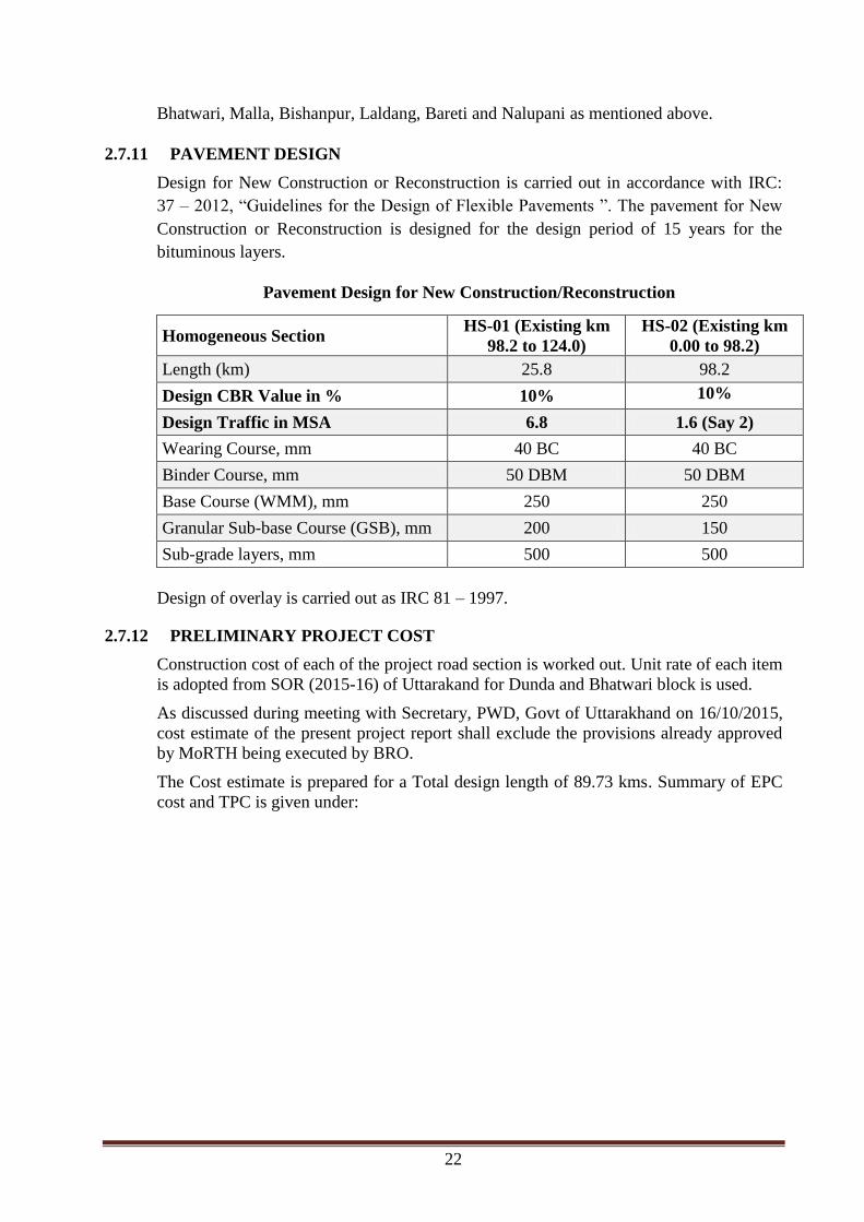
2.7.11 PAVEMENT DESIGN
Design for New Construction or Reconstruction is carried out in accordance with IRC:
37 – 2012, “Guidelines for the Design of Flexible Pavements ”. The pavement for New
Construction or Reconstruction is designed for the design period of 15 years for the
bituminous layers.
Pavement Design for New Construction/Reconstruction
Homogeneous Section HS-01 (Existing km
98.2 to 124.0)
HS-02 (Existing km
0.00 to 98.2)
Length (km) 25.8 98.2
Design CBR Value in % 10% 10%
Design Traffic in MSA 6.8 1.6 (Say 2)
Wearing Course, mm 40 BC 40 BC
Binder Course, mm 50 DBM 50 DBM
Base Course (WMM), mm 250 250
Granular Sub-base Course (GSB), mm 200 150
Sub-grade layers, mm 500 500
Design of overlay is carried out as IRC 81 – 1997.
2.7.12 PRELIMINARY PROJECT COST
Construction cost of each of the project road section is worked out. Unit rate of each item
is adopted from SOR (2015-16) of Uttarakand for Dunda and Bhatwari block is used.
As discussed during meeting with Secretary, PWD, Govt of Uttarakhand on 16/10/2015,
cost estimate of the present project report shall exclude the provisions already approved
by MoRTH being executed by BRO.
The Cost estimate is prepared for a Total design length of 89.73 kms. Summary of EPC
cost and TPC is given under:

23
EPC Cost of Project
Item Amount
(Rupees)
Amount
(Rupees
Cr.)
A Total Civil Cost 6,89,90,82,558 689.91
B Contingencies @ 2.8% of (1) 19,31,74,312 19.32
C Sub Total (A+B) 7,09,22,56,869 709.23
D Construction Supervision Charge @ 3% on C 21,27,67,706 21.28
E Administrative/Agency Charges @ 3% on (C+D) 21,91,50,737 21.92
F Quality Control Charges @ 0.25% on C 1,77,30,642 1.77
G Road Safety Audit Charges @ 0.25% on C 1,77,30,642 1.77
H Add Maintenance for 4 years @ 1.75% on C 12,41,14,495 12.41
I Escalation @ 10% on C 70,92,25,687 70.92
Total EPC Cost 8,39,29,76,779 839.30
Total project Cost
Item Amount
(Rupees)
Amount
(Rupees
Cr.)
A Total EPC Cost 8,39,29,76,779 839.30
B Cost of Land Acquisition 21,38,88,675 21.4
C Cost of R & R 23,24,70,000 23.25
D Cost of Environmental Mitigation Plan 26,80,36,468 26.80
Total Project Cost (TPC) 910.75
2.7.13 FINANCIAL VIABILITY
The project is financially Not Viable on BOT basis even with 40% Grant and 30 years
Concession Period. Accordingly project should be undertaken on EPC/annuity. Hence
consultant recommends the project road to be developed on EPC basis.