grading plan check checklist development & … · grading plan check checklist . public works...
TRANSCRIPT
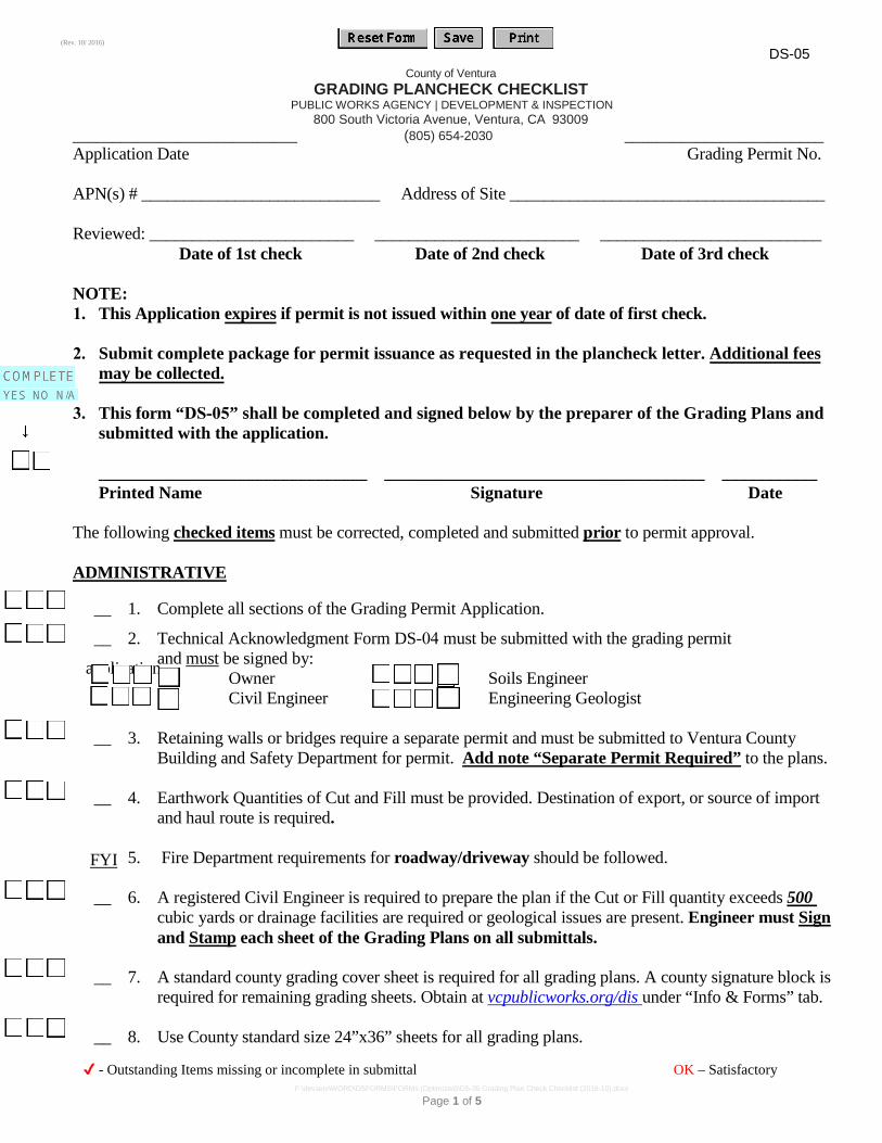
DS-05 County of Ventura
(Rev. 10/ 2016)
GRADING PLANCHECK CHECKLIST PUBLIC WORKS AGENCY | DEVELOPMENT & INSPECTION
800 South Victoria Avenue, Ventura, CA 93009 ____________________________ (805) 654-2030 _________________________ Application Date Grading Permit No.
APN(s) # ____________________________ Address of Site _____________________________________
Reviewed: ________________________ ________________________ __________________________ Date of 1st check Date of 2nd check Date of 3rd check
NOTE: 1. This Application expires if permit is not issued within one year of date of first check.
2. Submit complete package for permit issuance as requested in the plancheck letter. Additional fees may be collected.
3. This form “DS-05” shall be completed and signed below by the preparer of the Grading Plans and submitted with the application.
_______________________________ _____________________________________ ___________ Printed Name Signature Date
The following checked items must be corrected, completed and submitted prior to permit approval.
ADMINISTRATIVE
__ 1. Complete all sections of the Grading Permit Application.
__ 2. Technical Acknowledgment Form DS-04 must be submitted with the grading permit
application and must be signed by: Owner Soils Engineer Civil Engineer Engineering Geologist
__ 3. Retaining walls or bridges require a separate permit and must be submitted to Ventura CountyBuilding and Safety Department for permit. Add note “Separate Permit Required” to the plans.
__ 4. Earthwork Quantities of Cut and Fill must be provided. Destination of export, or source of importand haul route is required.
__ 5. Fire Department requirements for roadway/driveway should be followed.
__ 6. A registered Civil Engineer is required to prepare the plan if the Cut or Fill quantity exceeds 500cubic yards or drainage facilities are required or geological issues are present. Engineer must Sign and Stamp each sheet of the Grading Plans on all submittals.
__ 7. A standard county grading cover sheet is required for all grading plans. A county signature block isrequired for remaining grading sheets. Obtain at vcpublicworks.org/dis under “Info & Forms” tab.
__ 8. Use County standard size 24”x36” sheets for all grading plans.
FYI
✔ - Outstanding Items missing or incomplete in submittal OK – Satisfactory
Page 1 of 5 F:\devserv\WORD\DSFORMS\FORMs (Optimized)\DS-35 Grading Plan Check Checklist (2016-10).docx
DS-05 (Rev. 10/ 2016)
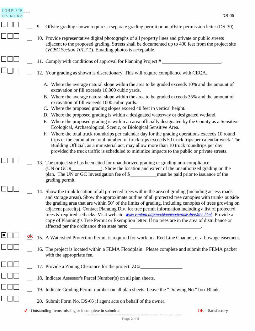
__ 9. Offsite grading shown requires a separate grading permit or an offsite permission letter (DS-30).
__ 10. Provide representative digital photographs of all property lines and private or public streetsadjacent to the proposed grading. Streets shall be documented up to 400 feet from the project site (VCBC Section 101.7.1). Emailing photos is acceptable.
__ 11. Comply with conditions of approval for Planning Project # ________________________.
__ 12. Your grading as shown is discretionary. This will require compliance with CEQA.
A. Where the average natural slope within the area to be graded exceeds 10% and the amount ofexcavation or fill exceeds 10,000 cubic yards.
B. Where the average natural slope within the area to be graded exceeds 35% and the amount ofexcavation of fill exceeds 1000 cubic yards.
C. Where the proposed grading slopes exceed 40 feet in vertical height.D. Where the proposed grading is within a designated waterway or designated wetland.E. Where the proposed grading is within an area officially designated by the County as a Sensitive
Ecological, Archaeological, Scenic, or Biological Sensitive Area.F. Where the total truck roundtrips per calendar day for the grading operations exceeds 10 round
trips or the cumulative total number of truck trips exceeds 50 truck trips per calendar week. TheBuilding Official, as a ministerial act, may allow more than 10 truck roundtrips per dayprovided the truck traffic is scheduled to minimize impacts to the public or private streets.
__ 13. The project site has been cited for unauthorized grading or grading non-compliance. (UN or GC #____________). Show the location and extent of the unauthorized grading on the plan. The UN or GC Investigation fee of $___________must be paid prior to issuance of the grading permit.
__ 14. Show the trunk location of all protected trees within the area of grading (including access roads and storage areas). Show the approximate outline of all protected tree canopies with trunks outside the grading area that are within 50’ of the limits of grading, including canopies of trees growing on adjacent parcel(s). Contact Planning Div. for tree permit information including a list of protected trees & required setbacks. Visit website: www.ventura.org/rma/planning/permits/tree/tree.html. Provide a copy of Planning’s Tree Permit or Exemption letter. If no trees are in the area of disturbance or affected per the ordinance then state here: _____________________________.
__ 15. A Watershed Protection Permit is required for work in a Red Line Channel, or a flowage easement.
__ 16. The project is located within a FEMA Floodplain. Please complete and submit the FEMA packetwith the appropriate fee.
__ 17. Provide a Zoning Clearance for the project. ZC#_________________
__ 18. Indicate Assessor's Parcel Number(s) on all plan sheets.
__ 19. Indicate Grading Permit number on all plan sheets. Leave the “Drawing No.” box Blank.
__ 20. Submit Form No. DS-03 if agent acts on behalf of the owner.
✔ - Outstanding Items missing or incomplete in submittal OK – Satisfactory
Page 2 of 5 F:\devserv\WORD\DSFORMS\FORMs (Optimized)\DS-35 Grading Plan Check Checklist (2016-10).docx
DS-05 (Rev. 10/ 2016)
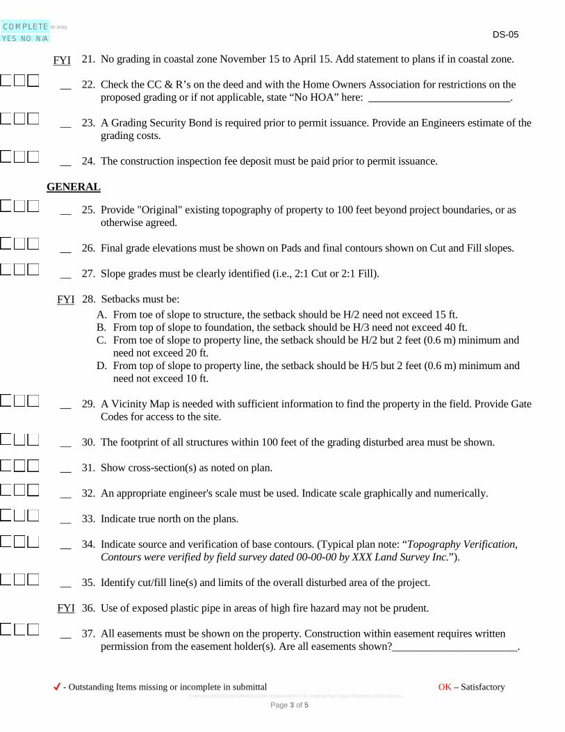
__ 21. No grading in coastal zone November 15 to April 15. Add statement to plans if in coastal zone.
__ 22. Check the CC & R’s on the deed and with the Home Owners Association for restrictions on theproposed grading or if not applicable, state “No HOA” here: __________________________.
__ 23. A Grading Security Bond is required prior to permit issuance. Provide an Engineers estimate of thegrading costs.
__ 24. The construction inspection fee deposit must be paid prior to permit issuance.
GENERAL
__ 25. Provide "Original" existing topography of property to 100 feet beyond project boundaries, or asotherwise agreed.
__ 26. Final grade elevations must be shown on Pads and final contours shown on Cut and Fill slopes.
__ 27. Slope grades must be clearly identified (i.e., 2:1 Cut or 2:1 Fill).
__ 28. Setbacks must be:A. From toe of slope to structure, the setback should be H/2 need not exceed 15 ft.B. From top of slope to foundation, the setback should be H/3 need not exceed 40 ft.C. From toe of slope to property line, the setback should be H/2 but 2 feet (0.6 m) minimum and
need not exceed 20 ft.D. From top of slope to property line, the setback should be H/5 but 2 feet (0.6 m) minimum and
need not exceed 10 ft.
__ 29. A Vicinity Map is needed with sufficient information to find the property in the field. Provide GateCodes for access to the site.
__ 30. The footprint of all structures within 100 feet of the grading disturbed area must be shown.
__ 31. Show cross-section(s) as noted on plan.
__ 32. An appropriate engineer's scale must be used. Indicate scale graphically and numerically.
__ 33. Indicate true north on the plans.
__ 34. Indicate source and verification of base contours. (Typical plan note: “Topography Verification,Contours were verified by field survey dated 00-00-00 by XXX Land Survey Inc.”).
__ 35. Identify cut/fill line(s) and limits of the overall disturbed area of the project.
__ 36. Use of exposed plastic pipe in areas of high fire hazard may not be prudent.
__ 37. All easements must be shown on the property. Construction within easement requires writtenpermission from the easement holder(s). Are all easements shown?_______________________.
FYI
FYI
FYI
✔ - Outstanding Items missing or incomplete in submittal OK – Satisfactory
Page 3 of 5 F:\devserv\WORD\DSFORMS\FORMs (Optimized)\DS-35 Grading Plan Check Checklist (2016-10).docx
(Rev. 10/ 2016) DS-05
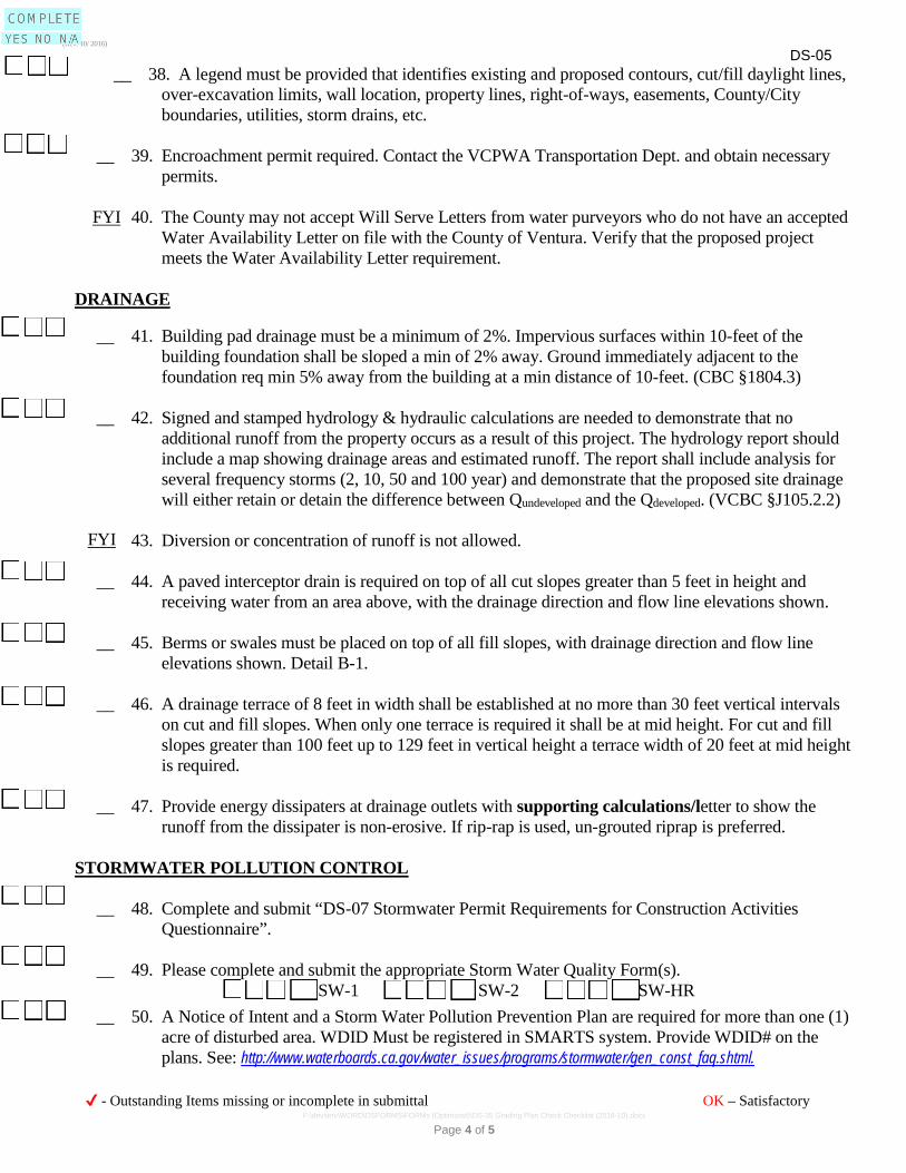
__ 38. A legend must be provided that identifies existing and proposed contours, cut/fill daylight lines, over-excavation limits, wall location, property lines, right-of-ways, easements, County/City boundaries, utilities, storm drains, etc.
__ 39. Encroachment permit required. Contact the VCPWA Transportation Dept. and obtain necessary permits.
__ 40. The County may not accept Will Serve Letters from water purveyors who do not have an accepted Water Availability Letter on file with the County of Ventura. Verify that the proposed project meets the Water Availability Letter requirement.
DRAINAGE
__ 41. Building pad drainage must be a minimum of 2%. Impervious surfaces within 10-feet of the building foundation shall be sloped a min of 2% away. Ground immediately adjacent to the foundation req min 5% away from the building at a min distance of 10-feet. (CBC §1804.3)
__ 42. Signed and stamped hydrology & hydraulic calculations are needed to demonstrate that no additional runoff from the property occurs as a result of this project. The hydrology report should include a map showing drainage areas and estimated runoff. The report shall include analysis for several frequency storms (2, 10, 50 and 100 year) and demonstrate that the proposed site drainage will either retain or detain the difference between Qundeveloped and the Qdeveloped. (VCBC §J105.2.2)
__ 43. Diversion or concentration of runoff is not allowed.
__ 44. A paved interceptor drain is required on top of all cut slopes greater than 5 feet in height andreceiving water from an area above, with the drainage direction and flow line elevations shown.
__ 45. Berms or swales must be placed on top of all fill slopes, with drainage direction and flow lineelevations shown. Detail B-1.
__ 46. A drainage terrace of 8 feet in width shall be established at no more than 30 feet vertical intervalson cut and fill slopes. When only one terrace is required it shall be at mid height. For cut and fill slopes greater than 100 feet up to 129 feet in vertical height a terrace width of 20 feet at mid height is required.
__ 47. Provide energy dissipaters at drainage outlets with supporting calculations/letter to show therunoff from the dissipater is non-erosive. If rip-rap is used, un-grouted riprap is preferred.
STORMWATER POLLUTION CONTROL
__ 48. Complete and submit “DS-07 Stormwater Permit Requirements for Construction ActivitiesQuestionnaire”.
__ 49. Please complete and submit the appropriate Storm Water Quality Form(s). SW-1 SW-2 SW-HR
__ 50. A Notice of Intent and a Storm Water Pollution Prevention Plan are required for more than one (1)acre of disturbed area. WDID Must be registered in SMARTS system. Provide WDID# on the plans. See: http://www.waterboards.ca.gov/water_issues/programs/stormwater/gen_const_faq.shtml.
FYI
FYI
✔ - Outstanding Items missing or incomplete in submittal OK – Satisfactory
Page 4 of 5 F:\devserv\WORD\DSFORMS\FORMs (Optimized)\DS-35 Grading Plan Check Checklist (2016-10).docx
DS-05 (Rev. 10/ 2016)
__ 51. Complete and submit Form DS-06 “Stormwater Permit Requirements for New Development andRedevelopment Questionnaire”. If Post construction BMP’s are required, please contact the Surface Water Quality Section at (805) 662-6737.
GEOTECHNICAL
__ 52. Geotechnical Reports have been reviewed. An addendum report is required.
__ 53. Indicate the septic system on the plan. Show cross section if grading and septic system adjoin eachother.
__ 54. Show rock disposal detail if oversized rock is to be incorporated in the fills.
__ 55. Show benching of slope per soils report.
__ 56. Show over excavation and re-compaction areas delineated by the soils report.
__ 57. Complete lower left hand corner of the title sheet. Soils engineer and geologist must Sign andStamp the cover sheet at final submittal/permit issuance.
ADDITIONAL ITEMS:
**Return all plan check materials with resubmittal. A response is required to all checked items.** Provide response to all review comments on this checklist or directly on the plan.
✔ - Outstanding Items missing or incomplete in submittal OK – Satisfactory
Page 5 of 5 F:\devserv\WORD\DSFORMS\FORMs (Optimized)\DS-35 Grading Plan Check Checklist (2016-10).docx