graham highways history - platz brothers … highways history.pdfthe graham county area was open to...
TRANSCRIPT


2
A SHORT HISTORY OF GRAHAM COUNTY HIGHWAYS
By George Platz
INTRODUCTION
Today we take for granted the ease with which we can travel within Graham
County and beyond—an hour or so from one end of the county to another, two hours
from Graham County to Tucson, three hours to Phoenix. But it wasn’t always this
way. Indeed, not until the 1930s was there a paved road all the way from Graham
County to Phoenix, and not until the mid-1940s was there such a route to Tucson.
The purpose of this paper is to provide a brief summary of the development of
major roads within Graham County and to important junctions elsewhere. The focus
of the paper will be on the history of Graham County state and federal highways
subsequent to the advent of the automobile and Arizona statehood, both of which
occurred at roughly the same time. Pre-automobile trails and roads will also be
discussed by way of background, as will a few significant county roads that are not
part of state and federal routes.
PRE-AUTOMOBILE ROADS AND TRAILS
Travel within and through Graham County did not begin with the arrival of
Europeans. There is evidence of habitation of this area for hundreds and perhaps
thousands of years before that, and some students of archaeology believe that the
population of what is now Graham County may have been as great 700 years ago as it
is today. These Native Americans had to travel to and from and within the Graham
County area, and they developed distinct routes for these travels. Evidence has been
found for some of these Indian trails, such as a trail that led north and south through
Eagle Pass between the Santa Teresa and Pinaleno mountains in the same area where
Klondyke Road runs today. But because these travelers did not possess wheeled
vehicles or even horses prior to the arrival of Europeans, few traces of most of their
trails exist and their precise location is a matter of speculation.
The Coronado Trail
The first significant travel into the Graham County area by Europeans is thought
to be the Coronado Expedition of 1540-42, which according to some sources entered
what is now Arizona from Mexico along the San Pedro River and then moved
northeast through the County and then northward in Eastern Arizona to the pueblos of
Northeastern Arizona and Northwestern New Mexico. The following National Park
Service map adopts this route

3
Hence the naming of U.S. Highway 191 north of Clifton as the Coronado Trail.
Papers recently published by historians from New Mexico, however, suggest that
Coronado may have taken a route that did not enter Graham County but traveled
eastward from the San Pedro through northern Cochise County and then into New
Mexico before heading northward through Western New Mexico. See
www.chichilticale.com and also http://southern-new-
mexico.org/html/the_coronado_expedition.html. In any event, whatever route
Coronado followed, he did not blaze any trail that modern travelers have followed.
Gen. Kearny’s Trail
Some 300 years after Coronado, in the 1840s, there was still relatively little
European development in the Graham County area, and there were no significant
roads. The area was part of Mexico, but the Mexican-American War was about to
change that. During that conflict, General Stephen Watts Kearny was appointed to
lead the forces of the U.S. Army in the western part of the disputed territory, called
the Army of the West. Kearny and his army had taken Santa Fe without firing a shot
on August 18, 1846, and he set out from there to support the U.S. forces who had just
taken California. He determined that the most direct route possible would take him
from Santa Fe down the Rio Grande to near what is now Truth Or Consequences,
NM, and then west to the Gila River. Before reaching the Gila he met up with Kit
Carson, who was familiar with the territory through which Kearny planned to move
and who advised Kearny that it was rough terrain not suitable for wagons. Kearny
sent his wagons and all but 100 of his men back to Santa Fe and then proceeded to the
Gila.
Kearny and his reduced Army of the West reached the Duncan, AZ area on
October 23, 1846. They set out from there on October 25, made a difficult march
through the Black Hills to avoid the Gila River canyons, entered what is now Graham
County, and on October 27 camped at the confluence of Bonita Creek and the Gila.
They continued to pass through Graham County along the Gila until they reached the
San Carlos River on October 31, having thus taken approximately a week to travel
from the east end of Graham County to the west. A recent account of this part of

4
Kearny’s journey, written by Tom Jonas and based upon the journals of several of
Kearny’s officers, may be found at www.southwesternexplorations.com. The
following map of Kearny ‘s trail drawn by Lieutenant W. H. Emory, who
accompanied the expedition, is reproduced on the Jonas website:
(Note that the river identified as Rio San Francisco on Emory’s map is now known as
the San Carlos River, and that identified by Emory as San Carlos is now called Bonita
Creek.)
Needless to say, reports of the difficulties of Kearny’s march did not encourage
many others to follow his trail. Although some prospectors followed his route on
their way to California during the Gold Rush of 1849, the hardships he encountered in
traveling through Graham County undoubtedly contributed to the decisions of later
pioneers (such as the Mormon Battalion, others seeking California gold, and the
Butterfield Stage), as well as later entrepreneurs (such as the builders of the Southern
Pacific, the second transcontinental railroad, which was completed in 1881) and even
modern day planners of the Interstate Highway System to place their more circuitous
routes across Southeastern Arizona through Cochise County, not Graham County.
Roads of the Late 1800s
After the end of the Mexican-American War and the Gadsden Purchase in 1853
(adding to the United States the portion of Graham County south of the Gila River),
the Graham County area was open to settlement by farmers and cattlemen and miners
and other pioneers from the U.S. Standing in their way, however, were the Apache
Indians, who had not signed any treaties relinquishing their rights to the area and who
were inclined to continue their raiding ways against new settlers. In order to protect
the settlers, the U.S. Army established a presence in Graham County with as many as
5000 troops and scouts and three forts: Fort Goodwin, located near Geronimo,
5
established in 1864 but discontinued in 1871; Fort Grant, moved from the San Pedro
River to the southern foothills of Mt. Graham in 1872; and Fort Thomas, established
near the Gila River seven miles southeast of the former Fort Goodwin in 1876. All
these settlers and all these troops and their forts required roads for their wagons and
stagecoaches and other wheeled vehicles.
Because the main stagecoach and railroad routes through southern Arizona in the
last half of the 1800s went through Cochise County to the south, the principal roads
serving the Army and the settlers in Graham County at that time ran to the south to
join these through routes. Prior to the arrival of the railroad, a stagecoach road from
Fort Lowell, near Tucson, went eastward to Point of Mountain station just south of the
Winchester mountains, where it connected to the main east-west stage line and to a
branch stage line going north through the northwest edge of the Sulphur Springs
Valley into Graham County and then branched east to Fort Grant and north through
Eagle Pass between the Santa Teresa and Pinaleno mountains (like the old Indian trail
described earlier) to Fort Thomas. These roads thus connected Fort Grant and Fort
Thomas in Graham County with each other and with Fort Lowell. A detailed
description of these stage routes may be found in a paper entitled Billie Whelan Jr.’s
Hand Drawn Map by Hal Herbert in the Graham County Historical Society 2002
Symposium Papers.
Fort Thomas was connected to another fort by a military road that went north
across the Gila to the west of Fort Thomas and then continued through northern
Graham County and the San Carlos reservation to Fort Apache. This road was also
part of the Mormon Wagon Road or “Honeymoon Trail” by which Mormon couples
traveled to a temple in Utah to be married. And Fort Grant was connected to Gila
River sites by another road that ran eastward through Stockton Pass (where U.S. 266
may be found today) and then branched northward to the river and eastward to Ash
Spring, near Duncan.
After the Southern Pacific railroad was completed across southern Arizona in
1881, additional stagecoach and wagon roads connected Graham County with the
railroad. The wagon roads to Fort Grant and through Eagle Pass to Fort Thomas were
extended south to the railroad line at Willcox. Another wagon road to Fort Thomas
ran from the railroad at Bowie north to Solomonville (now Solomon) in Graham
County and then west along the Gila through Safford to the Fort. These roads carried
not only supplies from the railroad to the forts but also copper from the mines in
Globe to the railroad via a connection to a road from Globe through San Carlos to
Fort Thomas. They were in use until the Gila Valley, Globe & Northern Railroad
(now the Arizona Eastern) was constructed from Bowie through Solomon to Fort
Thomas, beginning in 1894 and finally reaching Globe in 1899. The following
picture of a freight wagon on an Eagle Pass road in the late 1800s shows what these
roads and their vehicles looked like:

6
Details of these Graham County stage and wagon roads may be found in a paper by
Hal Herbert entitled Retracing the Old Ft. Grant-Camp Thomas Road in the Graham
County Historical Society 2001 Symposium and in a 2004 monograph by the same
author entitled The Road from Ft. Bowie to Solomonville, Graham County during the
1880s, which is available from the Society.
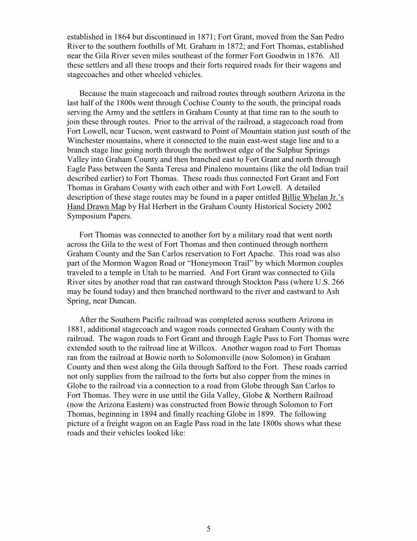
Many of the late 1800s roads mentioned above, and some others, are shown in the
following 1881 map of Graham County and adjacent areas:
7
DEVELOPMENT OF HIGHWAYS FOR THE AUTOMOBILE
Prior to Arizona becoming a state on February 14, 1912, the construction of
highways in the Arizona Territory was primarily left to the counties. (Graham County
was formed in 1881.) The Territorial Legislature had authorized toll road companies
as early as 1864 and had also declared that certain existing roads, developed solely by
usage, were free county roads not subject to tolls. A Territorial Engineer was
appointed in 1909, and the Office of State Engineer was established at the time of
statehood. Thereafter the planning, construction and maintenance of highways in
Arizona became largely a function of the state government.
Arizona Highways in 1913
At the time Arizona became a state it had several thousand miles of intercity
roads, but practically all were graded dirt or at best gravel, often without bridges over
Arizona’s seasonal rivers and streams, and often impassible in wet weather. But the
age of the automobile had arrived. The first automobile in Tucson was delivered in
1899, and by 1913 there were about 5,000 motor vehicles registered in Arizona, and

8
people were driving their cars on these roads, albeit slowly. An average speed of
twelve miles per hour was to be expected, with frequent stops for mechanical
adjustments, the fording of those seasonal streams, and asking directions in the
absence of well-marked routes. It would not have been unreasonable to expect the
trip from San Carlos, at the west end of Graham County, to Duncan, in Greenlee
County near the southeastern tip of Graham County, to take two or even three days—
about twice as fast as General Kearny’s Army of the West made the trip in 1846, but
more than the time it takes today to drive from Duncan to Kansas City!
In 1913 the Arizona Good Roads Association published an Illustrated Road Map
and Tour Book (reprinted by Arizona Highways magazine in 1976 and 1987)
describing the roads available for intercity travel in Arizona by automobile at that
time. The following map taken from that book shows three routes in Graham County
(the numbers on the map refer to pages in the Tour Book and not route numbers):
The east-west route from San Carlos to Duncan is similar to that of U.S. 70 today.
(Note that the town of Rice shown on this and several subsequent maps was
renamed San Carlos and the town of San Carlos shown on this map disappeared
after the construction of the Coolidge Dam on the Gila River in the late 1920s.)
Between Solomon and Duncan a toll road cutoff (similar to U.S. 191 today) meets
a road from Duncan to Clifton (similar to Arizona 75 today). The north-south
route from Mathews to Willcox is similar to that provided today by Klondyke
Road through Eagle Pass, Bonita-Klondyke Road, and Fort Grant Road, which,
interestingly, are still graded dirt roads in Graham County. The north-south route
from Solomonville to Bowie no longer exists, having been replaced by U.S. 191
from Safford to Interstate 10 in Cochise County. Detailed maps of each of these
three routes were also published in the 1913 Arizona Good Roads Association

9
Tour Book and are set out below. From those detailed maps it is easy to see some
of the difficulties of travel on those roads in 1913.

10
Arizona Highway Planning and Construction, 1914-1925
One of the first tasks that had to be undertaken by the newly appointed
Arizona State Engineer was the planning of Arizona’s statewide highway system.
The State Engineer’s report to the governor in 1914 proposed a north-south route
from the Grand Canyon to Douglas and the following east-west route from Yuma
to Duncan:
1914 Proposal
A portion of this first planned east-west highway through southern Arizona goes
through Graham County along a route similar to that taken by Gen. Kearny and
the Army of the West in 1846. The proposed route does not go directly from
Solomon to Duncan but detours by way of Clifton. This 1914 plan does not
include any highway connecting Graham County with Cochis County or Tucson
and proposes the highway from Graham County to Phoenix to go north from
Globe to Roosevelt and then along the Apache Trail from Roosevelt to Phoenix.
Other parts of the State Engineer’s 1914 report indicate that only a small amount
of work had been done on the Graham County portion of this projected highway
system, mainly surveying and a few miles of gravel laid.
By 1922, according to another State Engineer’s report, much of the system in
the 1914 plan had been completed, though most of it was still unpaved. In the
meantime, the federal government had become involved in the state road planning
and construction process. Recognizing that federal financial support was justified
in order to create a national transportation system, Congress had enacted

11
legislation providing for federal aid to build 7% of the roads in each state, with the
federally-financed roads to be designated by each state subject to federal approval.
The map below, copied from the 1922 Engineer’s Report, shows the highways in
southern Arizona proposed for the Seven Per Cent Highway System:
1922 Proposed 7% System
As far as Graham County is concerned, the 7% system is quite similar to the 1914
plan, although the new plan shows a road directly from Solomon to Duncan as
well as the route via Clifton. The Solomon to Clifton road was in fact built during
the period 1914-1920 with convict labor and apparently replaced the toll road
route between Solomon and Clifton shown in the 1913 Arizona Good Roads
Association Tour Book. It is still in existence, though little used, as part of the
Black Hills Scenic Byway. The 1922 report and earlier reports discuss at length
the desirability of using convict labor to build the state highway system and
generally conclude that the cost benefits of using that workforce instead of
private contractors are small because of the relative inefficiency of convict labor
and the extra costs of transporting, feeding and guarding the prisoners.
Outside of Graham County, the 7% system road from Graham County to
Phoenix now cuts directly through the Pinal Mountains from Globe to Superior
instead of going north through Roosevelt. The 1922 report states that the Globe-
Superior road, which was very expensive to build, opened in April 1922. The
report also estimates that when the 7% system is completed, it will be possible to
average 30 miles per hour taking any system road across Arizona, and mentions
that in the 1922 Arizona State Fair automobile race from Douglas to Phoenix the
winning car was able to average 50 miles per hour.
The 7% system plan still fails to include any route between Graham County
and Cochise County or Tucson, although the map does show the continued
existence of the old pre-1900 roads from Graham County to Bowie and to
Willcox, and the State Engineer in his report does recommend starting work on a
new road connecting Graham and Cochise counties. The 1922 report also notes

12
that construction is continuing on the Graham County routes and that pavement is
being laid through Safford, Thatcher and Pima.
The 1924 State Engineer’s report shows that the number of registered vehicles
in Arizona had increased from around 5,000 to almost 60,000. A traffic count
taken on the state highway near Central in Graham County in November 1924
indicated that some 381 cars had used the Safford-Pima section of the highway
during a 24-hour period. The 1924 report notes that the planning and construction
of state highways is now administered by a new Arizona Highway Department
and includes a map showing the Department’s current version of the state highway
system plan; the portion of that map for southern Arizona is set out below:
1924 Arizona Highway Department Plan
Also included in the 1924 report is the following more detailed map showing the
status of the state highway running through Graham County from San Carlos to
Duncan:
Status of San Carlos-Duncan State Highway in 1924

13
The detailed map shows that most of the San Carlos-Duncan state highway is still
unpaved and that much of it remains a graded dirt road. Little has occurred in
establishing a highway from Graham County to Cochise County or to Tucson. It is
somewhat surprising that the roads from Graham County to the Southern Pacific
railroad stations in Willcox and Bowie appear to be no better in 1924 than they were
in the late 1800s. Probably this is because there are no longer forts to supply in
Graham County, there is now a branch rail line running from Bowie to San Carlos and
on to Globe, and there is a road connection at Duncan to a New Mexico highway
leading to a railway station at Lordsburg.
Graham County Highway Development, 1926-1946
The implementation of the Arizona Highway Department Plan, and the
chronology of the development of Arizona’s state and federal highways, may be
tracked on the annual state highway maps prepared by the Department. Copies of
portions of these maps showing Graham County and nearby areas for the years 1926,
1930, 1934, 1940 and 1946 are set out and discussed below. (These Highway
Department maps are collected on the portion of the AARoads website
(www.aaroads.com) dealing with Arizona history and the images below have been
copied from that source.)

14
1926 Highway Department Map
This 1926 Highway Department map is little changed from the 1924 map, but it
does show that the state highways have now been assigned route numbers. The
east-west highway through Graham County (now U.S. 70) is designated as U.S.
Highway 180, and the Solomon to Clifton road is Arizona state highway 76. The
highway from Phoenix to Tucson and south through Tombstone, Bisbee and
Douglas is designated as U.S. Highway 80, indicating that it was planned to be the
major interstate highway through southern Arizona, thus continuing a trend of
avoiding Graham County that began after the Mexican-American war.

15
1930 Highway Department Map
This 1930 Highway Department map shows that a north-south route from
Graham County through Cochise County to Douglas has now been built, with the
designation of Arizona state highway 81 (following generally the route of today’s
U.S. Highway 191). Highway 81 is a graded dirt road through Graham County
and either graded dirt or gravel the rest of the way to Douglas. The road from that
route west to Benson, however, is still an unimproved road with no highway
number, so there is still no state or federal highway directly connecting Graham
County with Tucson. An unimproved Swift Trail is now shown running west of
Highway 81 south of Safford; construction of this road was begun in the 1920s
and completed to Columbine in 1933.
The 1930 map also shows that the road from Solomon to Clifton has been
redesignated as Arizona state highway 71, not 76, and that state route 71 extends
on north past Clifton to form the Coronado Trail highway. U.S. highway 180
running east-west across Graham County, like most Graham County highways
still largely unpaved, now clearly extends on the east into New Mexico to
Lordsburg and beyond. On the west end U.S.180 has been rerouted to the south of

16
the Gila River (where Coolidge Dam Road now runs today) around the new San
Carlos Lake formed by the Dam, which was completed in 1928 and dedicated by
President Coolidge in March 1930.
1934 Highway Department Map
This 1934 map shows that the road from Clifton to Duncan has now been
designated as Arizona state highway 75. The most interesting feature of this map
is that U.S. Highway 180 across Graham County is now shown to be paved all the
way, as is its extension to Lordsburg on the east and its extension (via U.S. 80) to
Phoenix on the west. Meanwhile, there is still no direct state or federal highway
from Graham County to Tucson, and what roads there are to Tucson are unpaved
east of Benson. Unlike the situation in the past, Graham County is now clearly
more closely connected by transportation links to Phoenix than to Tucson.

17
1940 Highway Department Map
This 1940 Arizona Highway Department map shows that U.S. Highway 180
running east and west through Graham County has now been redesignated as U.S.
Highway 70. Arizona State Highways 71 and 81 have now been jointly
designated as part of north-south U.S. Highway 666. (This designation, discussed
in more detail below, resulted from the practice of numbering three-digit tributary
U.S. highways after the main two-digit U.S. interstate routes that they served, in
this case U.S. Highway 66 from Chicago to Los Angeles, which ran across
northern Arizona.) A portion of U.S. 666 in Graham County south of Safford has
now been paved, but the rest is now a gravel road, so there is still no paved road
all the way from Graham County to Tucson.

18
1946 Highway Department Map
This 1946 Arizona Highway Department map shows that U.S. 666 south of
Safford has now been paved all the way into Cochise County, where it connects with
a newly paved Arizona state highway 86 running east and west from Benson to the
New Mexico state line. (U.S. 666 south of Highway 86, however, remains unpaved,
as it is north and south of Clifton.) There is thus for the first time a paved road
providing a direct connection between Graham County and Tucson.
19
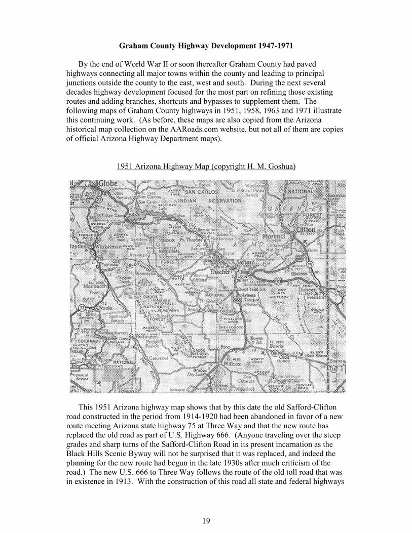
Graham County Highway Development 1947-1971
By the end of World War II or soon thereafter Graham County had paved
highways connecting all major towns within the county and leading to principal
junctions outside the county to the east, west and south. During the next several
decades highway development focused for the most part on refining those existing
routes and adding branches, shortcuts and bypasses to supplement them. The
following maps of Graham County highways in 1951, 1958, 1963 and 1971 illustrate
this continuing work. (As before, these maps are also copied from the Arizona
historical map collection on the AARoads.com website, but not all of them are copies
of official Arizona Highway Department maps).
1951 Arizona Highway Map (copyright H. M. Goshua)
This 1951 Arizona highway map shows that by this date the old Safford-Clifton
road constructed in the period from 1914-1920 had been abandoned in favor of a new
route meeting Arizona state highway 75 at Three Way and that the new route has
replaced the old road as part of U.S. Highway 666. (Anyone traveling over the steep
grades and sharp turns of the Safford-Clifton Road in its present incarnation as the
Black Hills Scenic Byway will not be surprised that it was replaced, and indeed the
planning for the new route had begun in the late 1930s after much criticism of the
road.) The new U.S. 666 to Three Way follows the route of the old toll road that was
in existence in 1913. With the construction of this road all state and federal highways

20
in Graham County are now paved, although U.S. 666 north of Clifton in Greenlee
County remains unpaved.
1958 Arizona Highway Map (copyright Rand McNally)
This 1958 Arizona highway map shows a state and federal highway configuration
in Graham County much the same as that in the 1951 map above, except with respect
to the western part of U.S. Highway 70. U.S. 70 now crosses the Gila River at Bylas
and remains north of the River and San Carlos Lake but south of San Carlos, thus
providing a much more direct route to Globe and points west than did the prior route.
The old U.S. 70, crossing over Coolidge Dam, remains as a San Carlos Reservation
road.

21
1963 Arizona Highway Department Map
This 1963 Arizona Highway Department map shows few changes from the 1958
map. U.S. 666 has now been paved north of Clifton. Swift Trail has now been
designated as Arizona state highway 366. The road from U.S. 666 south of Safford
west to Bonita has now been paved and designated as state highway 266. The road
northeast from Three Way through Black Jack Canyon to Mule Creek in New Mexico
has now been designated as Arizona state highway 78 but remains unpaved..

22
1971 Arizona Department of Transportation Highway Map
This 1971 map by the Arizona Department of Transportation (which has replaced
the Arizona Highway Department) shows the highways of Graham County and
vicinity in much the same configuration as they are today. The major change shown
by this map is the replacement of Arizona state highway 86 through northern Cochise
County by Interstate Highway 10. As of this map in 1971 Interstate 10 was
completed from the New Mexico state line to Tucson and west with the exception of a
short stretch east of Benson (Mileposts 303-311), which was completed in 1974.
Thus by the early 1970s there was a federal highway route from Graham County to

23
Tucson that for the first time clearly exceeded in quality and speed the route from
Graham County to Phoenix.
CONCLUSION
Although the current configuration of highways in and near Graham County was
set by the 1970s, a few changes worthy of note have taken place since then. In 1992,
the portion of U.S. Highway 666 running through Graham County was redesignated
as U.S. Highway 191. This was largely because U.S. Highway 66, of which U.S. 666
was a branch route and after which U.S. 666 was named, was eliminated as a result of
its replacement by Interstate Highways 40, 44, and 55 (but also to some extent
because the Bible, in Revelation 13:18, identifies “666” as “the number of the beast”
and some motorists found this troubling). An interesting article about this and many
other aspects of the complicated history of Route 666 may be found on the Federal
Highway Administration website
(http://www.fhwa.dot.gov/infrastructure/us666.cfm). In the mid-2000s, the Arizona
Department of Transportation began a program of upgrading U.S. Highway 191
between Safford and Interstate 10 to a divided four lane expressway, a project which
is about halfway completed as of 2011. This will further reestablish the preeminence
of Graham County highway connections to the south.
What the future holds for Graham County highways is unclear, but further
changes are certainly possible, especially if significant growth in the Upper Gila
Valley results from such projects as Freeport McMoran’s new copper mine north of
Safford and the potential construction of solar thermal electric generating facilities in
the San Simon Valley. Heavy traffic on U.S. 70 through the Safford area has already
prompted discussions of a possible U.S. 70 bypass, and Arizona Department of
Transportation planners have identified the desert area between Mt. Graham and the
Gila River communities as one of several possible locations for a section of interstate
highway allowing Interstate 10 traffic to bypass Tucson. While the status of such
developments is uncertain (especially over the long term in light of the inevitable
limits on the availability of inexpensive petroleum as a vehicle fuel), it is conceivable
that the next 100 years could see as many changes in Graham County highways as the
last 100 years have seen.
___________________________
The author wishes to acknowledge the support of the Graham County
Historical Society and its Director, Hal Herbert, in the preparation of this paper.