grand union canal route map - birmingham city council
TRANSCRIPT
Route Route continuescontinues
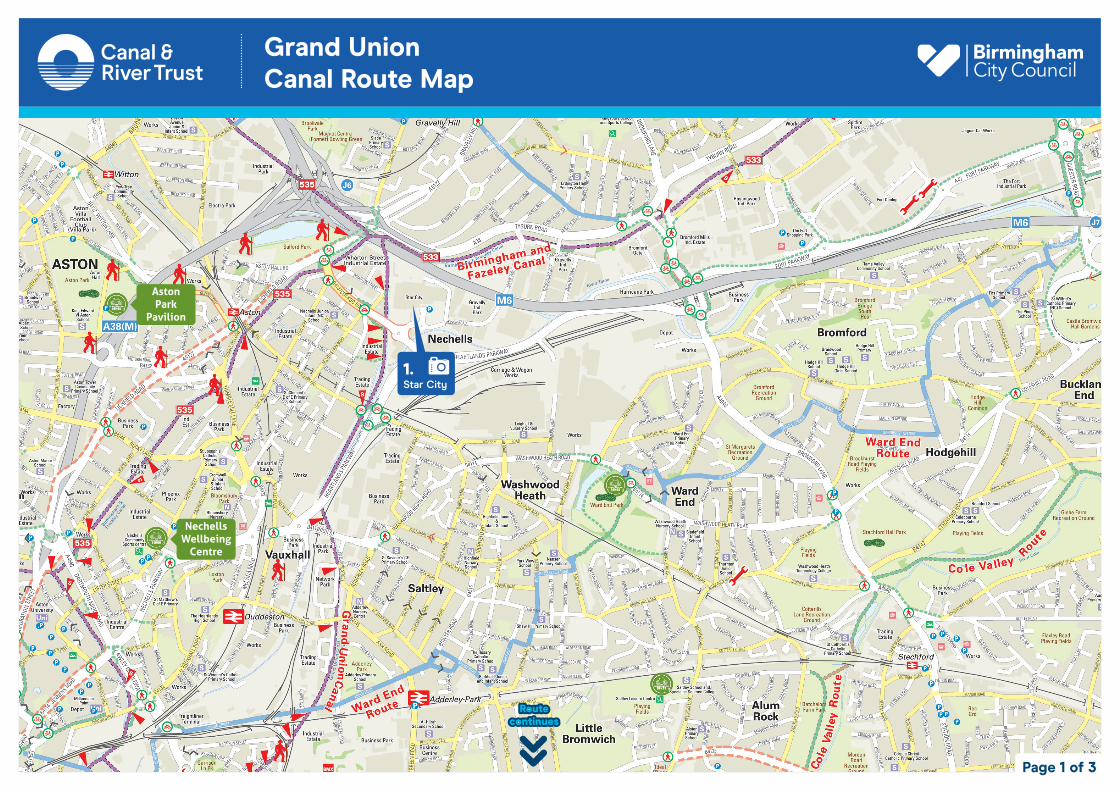
Aston Aston ParkPark
PavilionPavilion
NechellsNechellsWellbeing Wellbeing
CentreCentre
Grand UnionCanal Route Map
Page 1 of 3
1.Star City
Route Route continuescontinues
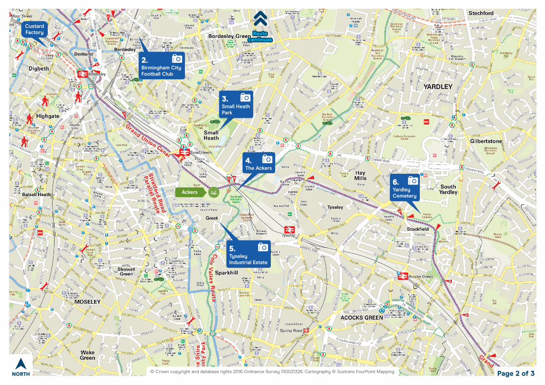
Custard Factory
Cole
Val
ley
Rout
e
Cole
Val
ley
Rout
e
AckersAckers
Page 2 of 3
© Crown copyright and database rights 2016 Ordnance Survey 100021326. Cartography © Sustrans FourPoint Mapping NORTH
2.Birmingham CityFootball Club
3.Small HeathPark
4.The Ackers
6.YardleyCemetery
5.Tyseley Industrial Estate
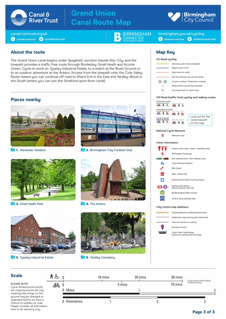
About the route
The Grand Union canal begins under Spaghetti Junction beside Star City, and the towpath provides a traffic free route through Bordesley, Small Heath and Acocks Green. Cycle to work on Tyseley Industrial Estate, to a match at the Blues Ground or to an outdoor adventure at the Ackers. Access from the towpath onto the Cole Valley Route means you can continue off road to Shard End in the East and Yardley Wood in the South (where you can join the Stratford-upon-Avon canal).
Places nearby
Map Key
Scale
Page 3 of 3
Brompton Docks
Cycle Chain Canal Barge(cycle hire, parking and servicing)
Tram line section no cycling
Canal access ramp / steps / wheeling ramp
Birmingham Greenway
2km walking route / 5km walking route
Cycle parking locations
Bike shops
BMX / Skate Park
Refreshments (within Country Parks)
Railway with station /Metro (tramline) with halt
Advisory cycle route (unsigned)
Signed cycle route
Cycle lane (on road)
Bus lane (cyclists can use bus lanes)
Toucan crossing / Pedestrian crossing
Steep hill (arrow pointing downhill)
One-way street on cycle route
National route
Big Birmingham Bikes Centre
Centro Cycle parking Hubs
Cycling allowed in pedestrianised areas
Pedestrian only areas (cyclists dismount)
On-Road cycling
Off-Road (traffic free) cycling and walking routes
National Cycle Network
City Centre map additions
Other information
Surfaced routes
Unsurfaced routes
Canal towpathLook out for the canal towpath on the map
PLEASE NOTE: Cycle infrastructure works are ongoing across the city meaning that things on the ground may be changed or upgraded before we have a chance to update our map. Please consider all information here to be advisory only.
1. Alexander Stadium 2. Birmingham City Football Club
3. Small Heath Park
5. Tyseley Industrial Estate
birmingham.gov.uk/cyclingbhamconnected @bhamconnected
canalrivertrust.org.uk/canalrivertrust @canalrivertrust
Grand UnionCanal Route Map
6. Yardley Cemetery
4. The Ackers