granite mountain avalanche fatality, december 31st,...
TRANSCRIPT

Granite Mountain Avalanche Fatality, December 31st, 2015 Report prepared by NWAC
Incident snapshot (All avalanche fields estimated from interview with Seattle Mountain Rescue)
Time and Date: Mid-day or afternoon, December 31st, 2015 Location: Granite Mountain, King County, Mt Baker-Snoqualmie Forest, Washington State Number in Party: 3 Snowshoers Number caught: 1 Number partially buried, non-critical (non-critical means head was exposed): 1 Number killed: 1 (Trauma)
Avalanche type: Hard Slab Trigger: est Snowshoer, Unintentional Size – Destructive Force: est D1 or D2 Size – Relative to Path: Unknown Start Zone Aspect: SSW Start Zone Elevation: Unknown Sliding surface: est In new snow
Height of Crown Face: Unknown Width of Fracture: Unknown Vertical Fall: Unknown, but presumed to be several hundred feet
Slab Hardness: est Pencil Slab Grain Type: est Wind broken precipitation particles or Wind Packed (Rounded Grains)
Terrain Trap: Yes, Trees in Runout Party crossed start zone before avalanche: Unknown Location of subject relative to Start Zone: Unknown Avalanche occurred during: Unknown Signs of Instability Noted by Group: Unknown
Avalanche safety gear carried by party: None Avalanche Training and Experience: Victim was a very experienced climber/snowshoer with at least some formal avalanche training and familiar with the NWAC avalanche forecast. The other two snowshoers reportedly had little experience. NWAC Forecast Zone: Snoqualmie Pass NWAC Avalanche Danger Rating in effect for start zone (near treeline): Moderate
Narrative and Rescue: After departing from the trailhead around 10:30 or 11:00 AM, the other two snowshoers in the group turned back near treeline (3900 ft) due to the strong winds and blowing snow. They were behind the victim and lost visual contact as he ascended above treeline and out of sight.
The initial 911 call was placed by the other members of the group in the afternoon after the victim failed to return. Seattle Mountain Rescue (SMR), one of several SAR units involved in the rescue effort, was contacted by King County Sheriff’s Office at 5:15 PM on 12/31/15.
A SMR team climbed through high winds during the evening and night of 12/31/15 to check the route and summit for the missing snowshoer. SMR bivyed in a snow cave near the summit until first light and then descended to continue searching.

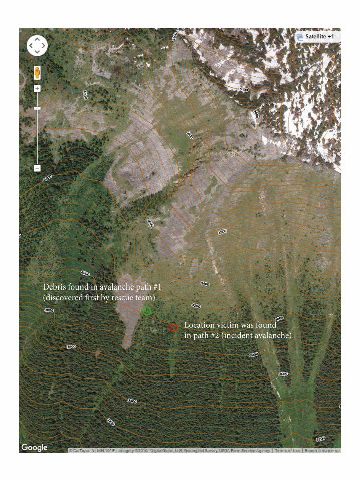
Olympic, Tacoma, and Everett Mountain Rescue teams were called in as well to help with the search on New Year's Day. As the SMR team descended, they found avalanche debris and requested the additional teams help search the area. Shortly after, an Olympic Mountain Rescue Team spotted the victim as they entered the debris field from below. All teams then worked to evacuate the victim back to the trailhead.
Supplemental Rescue Notes:
• Strong winds continued overnight and through the morning of the 1st, SMR estimated 70 mph, “lean intowind”, Beaufort scale interpretation for that description equals 34-40 knots (40-45 mph) with higher gusts likely.
• No large cornice formation: Traditional east facing cornices obliterated by east winds, only one east-facingcornice noted.
• Ridgelines scoured by winds, crampons used above treeline.
Comments from NWAC Forecasters (Dennis D'Amico)
After the snowiest week in Snoqualmie Pass’s recorded history (Dec 18th-24th) and the snowiest December overall (records courtesy WSDOT), December ended on a dry note with three consecutive dry days. Snoqualmie Pass weather station winds were consistently moderate out of the east 24-36 hours prior to this incident, with much stronger winds experienced west of the Snoqualmie Pass Summit, including at Granite Mountain (see photos/videos). Temperatures stayed cold due to the easterly flow despite free-air freezing levels significantly warming for areas further to the west such as the Olympics and Mt. Baker area.
Despite the lack of specifics regarding this incident, we can say that it was probable that the victim triggered a shallow wind slab that developed because of the strong east winds through the Snoqualmie Pass area. Several generally small skier triggered wind slabs were reported in the Snoqualmie Pass and Mt. Rainier area from December 30th through January 1st. Both areas are subject to east wind events loading non-traditional westerly aspects. Relevant public observations submitted to NWAC of shallow human triggered wind slab avalanches on December 31st are attached near the end of this report. The notable difference between the public observations and the fatal avalanche is that the fatal avalanche ended in a deadly treed terrain trap.
NWAC did not interview the other two members of the group whom had stopped near treeline while the victim continued his ascent. Since there were no witnesses with this incident, we do not know if the separate wind slab avalanche to the west (identified in photos) of the fatal avalanche was natural or human triggered.

Location victim was foundin path #2 (incident avalanche)
Debris found in avalanche path #1 (discovered first by rescue team)
Debris found in avalanche path #1 (discovered first by rescue team)
Location victim was foundin path #2 (incident avalanche)

Photos 1-4 by Russell Anschell of Seattle Mountain Rescue during recovery on January 1st, 2016
Photo 1: Looking uphill at avalanche path #2 (incident avalanche) where the victim was found. Victim was found about 30 feet to the left of the photo location.

Photo 2: Location where the victim was found in path #2.

Photo 3 and 4: Looking uphill and downhill respectively of avalanche path #1. Debris found in path #1 was discovered first. The victim was later located to the east in path #2.

Additional photos and videos from a solo climber on Granite Mountain that morning prior to the incident can be found at: http://www.nwhikers.net/forums/viewtopic.php?t=8019362

Northwest Avalanche Center — Observation http://www.nwac.us/observations/pk/262/
Recreational Observation
Skinning up to the "mainline chute" of the Kendall Chutes (approached via skiing Commonwealth Basin and Sterling Direct)
Dec. 31, 2015, noon PST
Weather: Clear, cold and windy.
Snowpack: Mostly dry, unconsolidated power, which some subtle crusts in some places, and some new shallow wind-affected/windslab in others (lee slopes near ridgelines).
Area Description: North facing slopes of the ridge above Kendall Lakes (Kendall Chutes)Avalanches: While skinning up to the "Mainline Chute" I set off a very small wind-deposited slab which propagated above me into a small, shallow dry/slab windslab avalanche that carried me about 50-100 feet with no burial or injury.Latitude: 47.438366Longitude: -121.379786Did you see any avalanches? YesDid you trigger any avalanches? Yes Was anyone caught in an Avalanche? Yes
forecasts observations blog education accidents events about support nwac

http://www.nwac.us/observations/pk/262/

Northwest Avalanche Center — Observation http://www.nwac.us/observations/pk/263/
Recreational Observation
Snoqualmie PassDec. 31, 2015, 10 a.m. PST
Elevation: Near treelineAspect: WDid you see any avalanches? NoDid you trigger any avalanches? NoWas anyone caught in an Avalanche? NoComments: On the west / leeward side of Tinkham, snow below the rideline was wind loaded for 50 - 100 feet below the crest (at 4.8K), and readily cracked, with limited propagation. This included the upper reaches of the Twin Lakes Couloir / Zipper Chute, which we declined to ski. Descending in the trees on the same aspact further south, the top 6 inches of snow were highly faceted and rotten feeling, but on a stable / solid base.
forecasts observations blog education accidents events about support nwac

Northwest Avalanche Center — Observation http://www.nwac.us/observations/pk/264/
Recreational Observation
Our party of two were coming out from an overnight in the Tatoosh area - following the road route from Refection Lake. When we arrived at the avalanche zone above Narada Falls, we observed many wind-blown features on the road and the route was completely covered. Further progress on the south end of the zone demonsrated some cracking (18" to 24") in the front of the snowshoes. Snowpack analysis reveled a wind-slab had been formed from the previous nights wind. Additionally, some surface hoar was observed on the night prior in the Refection Lake area. We deemed the route too dangerous and retreated to the Mazama Ridge route for safe crossing.Dec. 31, 2015, 8:15 a.m. PSTWeather: Clear sky with variable winds at 15-20 with gusts to 30.Snowpack: Storm layer well formed and consolidated. Observed 8" to 10" wind slab layer on NW Facing slope above Narada Falls.
forecasts observations blog education accidents events about support nwac
Area Description: Above Narada Falls / Inspiration Point - MRNP
Avalanches: No natural or human-triggered avalanches were observed.
Observation by Tim KirkLatitude: 46.774612Longitude: -121.743536Did you see any avalanches? NoDid you trigger any avalanches? No Was anyone caught in an Avalanche? No

Northwest Avalanche Center Washington Department of Transportation Snoqualmie Pass, Washington
3770' temp above Lake Keechelus
1/1 1000 11 10 14 86 24 32 87 0 0 0 74 1031
1/1 900 9 9 12 88 27 35 85 0 0 0 75 1031
1/1 800 11 9 11 89 28 38 85 0 0 0 75 1031
1/1 700 11 9 11 89 26 31 93 0 0 0 75 1031
1/1 600 11 9 12 89 22 29 95 0 0 0 75 1031
1/1 500 13 10 12 90 20 31 97 0 0 0 75 1031
12 14 13 89 18 25 114 0 0 0 75 1031
12 14 13 90 17 24 134 0 0 0 75 1031
12 15 13 88 17 24 119 0 0 0 75 1031
1/1 400
1/1 300
1/1 200
1/1 100 13 15 14 87 20 25 119 0 0 0 75 1032
1/1 0 12 17 14 88 18 24 132 0 0 0 75 1032
12 16 13 89 18 27 120 0 0 0 75 1033
13 12 13 90 21 29 85 0 0 0 74 1033
13 14 13 89 18 28 74 0 0 0 76 1033
13 13 13 89 20 28 78 0 0 0 76 1033
13 12 14 89 19 28 73 0 0 0 76 1032
14 14 14 89 20 28 72 0 0 0 75 1032
15 15 15 89 21 29 66 0 0 0 76 1033
16 17 17 87 18 29 65 0 0 0 76 1032
17 18 20 82 22 30 65 0 0 0 76 1032
17 17 22 75 24 34 70 0 0 0 75 1032
18 18 24 73 21 28 69 0 0 0 75 1032
17 17 24 74 16 26 63 0 0 0 75 1033
17 16 21 76 12 26 80 0 0 0 75 1033
15 14 17 84 14 26 90 0 0 0 76 1033
13 12 16 86 14 30 111 0 0 0 76 1032
15 12 14 87 13 22 100 0 0 0 75 1032
14 13 15 85 16 26 75 0 0 0 77 1031
15 13 14 89 21 28 81 0 0 0 77 1031
12/31 2300
12/31 2200
12/31 2100
12/31 2000
12/31 1900
12/31 1800
12/31 1700
12/31 1600
12/31 1500
12/31 1400
12/31 1300
12/31 1200
12/31 1100
12/31 1000
12/31 900
12/31 800
12/31 700
12/31 600
12/31 500 14 13 14 90 22 28 84 0 0 0 77 1031
MM/DDHour
PST
TempF
3760'
TempF
3770'
TempF
3010'
RH%
3010'
WindAvg
3760'
WindMax
3760'
WindDir
3760'
HourPrec.3010'
TotalPrec.3010'
24 HrSnow3010'
TotalSnow3010'
Pressmb
3010'
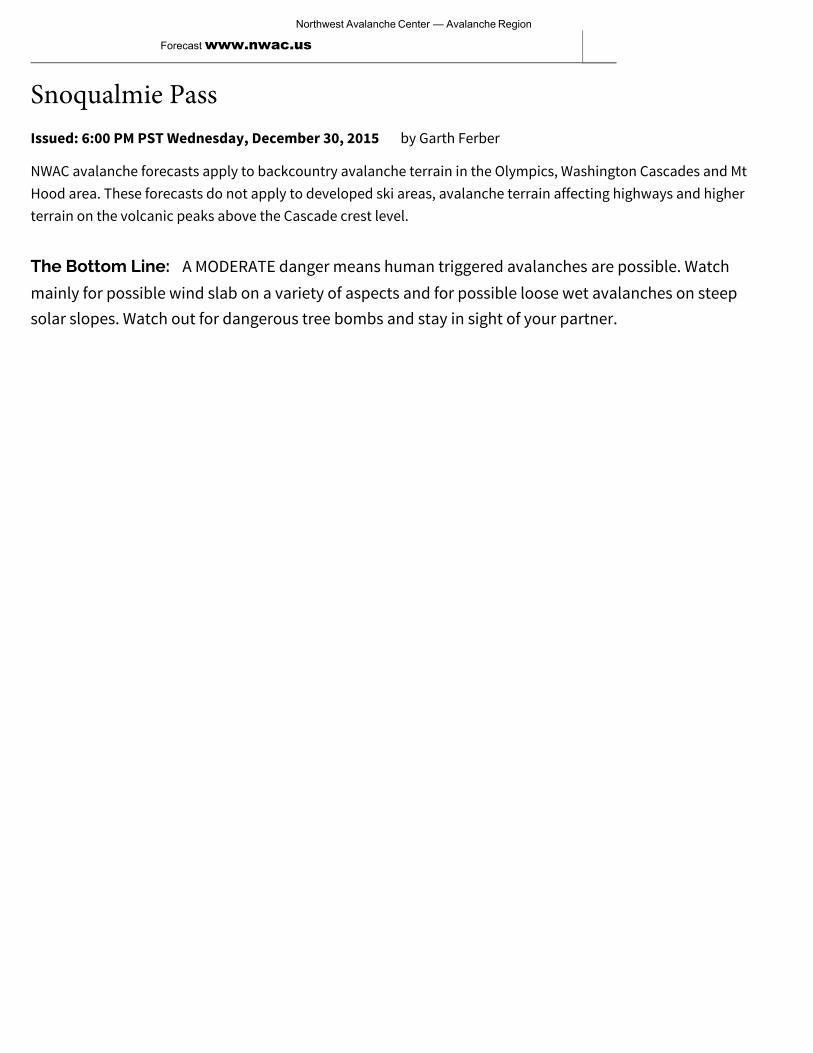
Issued: 6:00 PM PST Wednesday, December 30, 2015
Snoqualmie Passby Garth Ferber
NWAC avalanche forecasts apply to backcountry avalanche terrain in the Olympics, Washington Cascades and MtHood area. These forecasts do not apply to developed ski areas, avalanche terrain affecting highways and higherterrain on the volcanic peaks above the Cascade crest level.
The Bottom Line: A MODERATE danger means human triggered avalanches are possible. Watchmainly for possible wind slab on a variety of aspects and for possible loose wet avalanches on steepsolar slopes. Watch out for dangerous tree bombs and stay in sight of your partner.
Northwest Avalanche Center — Avalanche Region
Forecast www.nwac.us

Northwest Avalanche Center — Avalanche Region Forecast
Issued: 6:00 PM PST Wednesday, December 30, 2015
No Rating Low Moderate Considerable High ExtremeDanger Scale
by Garth Ferber
Elevation Thursday Outlook for Friday
Above TreelineModerate
Heightened avalancheconditions on specific terrainfeatures. Evaluate snow and
terrain carefully; identify problem features.
Moderate
Near TreelineModerate
Heightened avalancheconditions on specific terrainfeatures. Evaluate snow and
terrain carefully; identify problem features.
Moderate
Below TreelineLow
Generally safe, watch forunstable snow on isolatedterrain features.
Low

Northwest Avalanche Center — Avalanche Region Forecast
Issued: 6:00 PM PST Wednesday, December 30, 2015 by Garth Ferber
Avalanche Problems for Thursday
Wind Slab Wind slabs can take up to a week to stabilize. They are confined to lee and cross-loaded terrainfeatures and can be avoided by sticking to sheltered or wind scoured areas.
Loose Wet
Loose wet avalanches occur where water is running through the snowpack, and release at orbelow the trigger point. Avoid terrain traps such as cliffs, gullies, or tree wells. Exit avalancheterrain when you see pinwheels, roller balls, a slushy surface, or during rain-on-snow events.
Avalanche Problem Aspect/Elevation Likelihood Size
Avalanche Problem Aspect/Elevation Likelihood Size

Northwest Avalanche Center — Avalanche Region Forecast
Snowpack Analysis:A cool very snowy storm cycle brought 5-9 feet of snowfall along the west slopes the week ending December 24th. Light additionalaccumulations in the past week have allowed the snowpack to slowly settle with good skiing. A weak weather system Sunday andMonday helped create some new mostly small and mostly shallow wind slab in many areas.
There have been numerous triggered wind slabs the past week but with each passing day the ease of trigger seems to bediminishing. Storm slabs have all but settled and are no longer a problem of note. Storm snow has been gradually settling butremains mostly right side up and continues to offer some excellent conditions.
Here are summaries for a couple of the latest reports for the west slopes.
A report via the NWAC Observations for Moonlight Bowl on Skyline Ridge at Stevens Pass on Tuesday indicated generallyunreactive wind slab and right side up snow on steep north slopes and no signs of instability.
NWAC pro observer Lee Lazzara was in the Bagley Lake area near Mt Baker on Tuesday and found a generally right side up snowpack with some wind slab but also lacking a weak layer or interface. Lots of skiers around Bagley Lakes triggered only small loosedry avalanches. A small loose wet was also seen on the south side of Table Mountain.
NWAC pro observers Dallas Glass and Ian Nicholson were on Chair Peak at Snoqualmie today and reported that wind slab was a bitmore prevalent there than the past couple days. Dallas triggered a small wind slab on a 35-40 degree north slope at about 5500feet.They saw another skier triggered wind slab on a southwest slope about 600 feet below a ridge. They felt wind slab should bepossible there on a variety of slopes and to 1000 feet below ridges.
Detailed Forecast for Thursday:Sunny weather should be seen on Thursday. Warmer temperatures should be seen at higher elevations in the north Cascades byThursday afternoon. Cool temperatures with possible low clouds should be seen in the Cascade passes especially Snoqualmie.
This weather should allow older wind slab to continue to slowly settle and stabilize. Wind slab will most likely be found on north tosoutheast aspects near and above tree line. New wind slab may also be found on west to northwest aspects mainly in the CascadePasses. Any wind slab avalanches should be confined to surface layers. Watch and test for inverted strong over weak storm snow.
The sunny weather and warmer temperatures at higher elevations mainly in the north Cascades should bring the possibility ofloose wet avalanches Thursday afternoon on steep solar slopes. Watch for surface wet snow deeper than a few inches, initial rollerballs and natural loose wet avalanches on steep solar slopes where snow may shed from rocks or cliffs.
A lot of snow has been seen in trees lately along the west slopes. Stay away from trees if you see trees starting to shed snow due tosunny weather on Thursday afternoon. A tree bomb can be just as fatal as an avalanche!
There have been snow immersion fatalities in tree wells already this season at Snoqualmie and in Canada. Tree wells may still belurking so stick near your partner in the trees and maintain visual contact.

1
American Avalanche Association Forest Service National Avalanche Center Avalanche Incident Report: Short Form
Occurrence Date (YYYYMMDD): 20151231 and Time (HHMM): Comments: All avalanche charactistics and incident details are estimated from interviews with Seattle Mountain Rescue whom extracted the victim the next morning. No fracture line profile was visible the next day due to continued wind loading. NWAC was unable to interview the other two members of the victim's party. See full NWAC report for details and pictures. Reporting Party Name and Address: Dennis D'Amico
Northwest Avalanche Center 7600 Sandpoint Way, Bld 1 Seattle, WA 98115
Avalanche Characteristics: Type: HS Aspect: SSW Trigger: AI Slope Angle: Size: R \ D -12 Elevation: m / ft Sliding surface (check one):
In new New/old In old Ground
Location: State: WA County: King Forest: Mt Baker - Snoqualmie Peak, Mtn Pass, or Drainage: Granite Mountain Site Name: Lat/Lon or UTM:
Group Number of People Time
recovered Duration of burial
Depth to Face m / ft Caught 1
Partially Buried—Not critical
1 9:45 AM next day
est 18-24 hrs
Partially Buried--Critical Completely Buried Number of people injured: Number of people killed: 1
Dimensions m / ft
Average Maximum Height of Crown Face Width of Fracture Vertical Fall est several
hundred feet Snow Hardness Grain Type Grain Size (mm) Slab P Wind broken
precipitation particles or Wind Packed
Weak Layer Bed Surface Thickness of weak layer: mm / cm / in
Burial involved a terrain trap? no yes → type: Trees in Runout Number of people that crossed start zone before the avalanche: Unknown Location of group in relation to start zone during avalanche: high middle low below all unknown Avalanche occurred during ascent descent
Subject Name Age Gender Address Phone Activity 1 Doug Walker 65 M Seattle Snowshoeing 2 Unknown Snowshoeing 3 Unknown Snowshoeing 45
Equipment Carried 1 2 3 4 5
Transceiver Shovel Probe
Experience at Activity 1 2 3 4 5
Unknown Novice Intermediate Advanced
Avalanche Training 1 2 3 4 5
Unknown None Some Advanced
Expert Expert
2
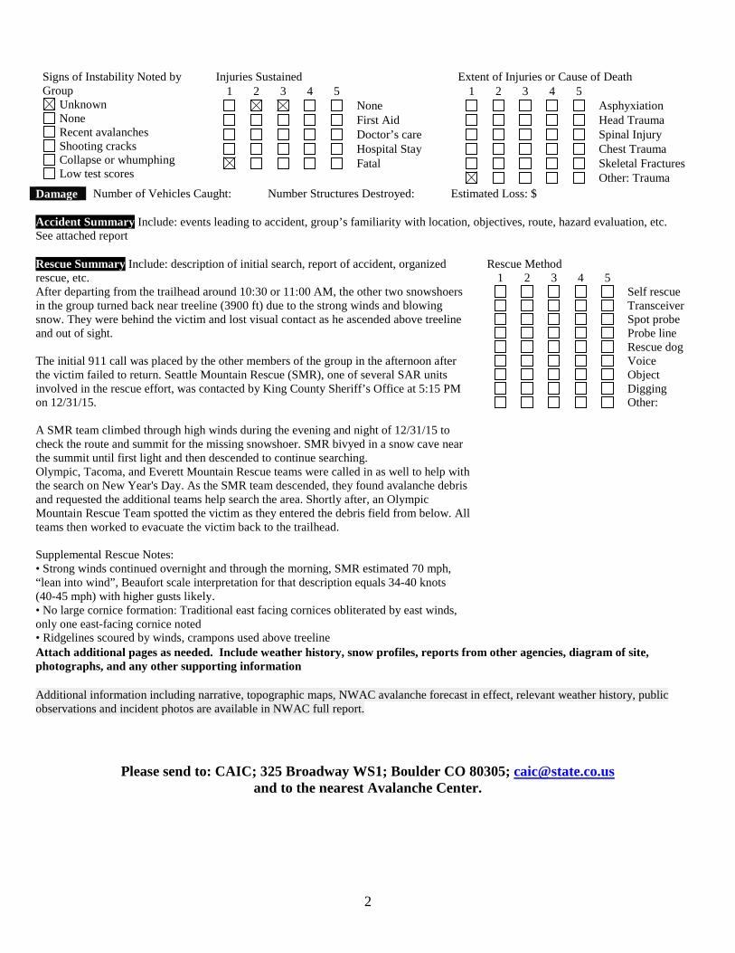
Signs of Instability Noted by Group
Unknown None Recent avalanches Shooting cracks Collapse or whumphing Low test scores
Injuries Sustained 1 2 3 4 5
None First Aid Doctor’s care Hospital Stay Fatal
Extent of Injuries or Cause of Death 1 2 3 4 5
Asphyxiation Head Trauma Spinal Injury Chest Trauma Skeletal Fractures Other: Trauma
Damage Number of Vehicles Caught: Number Structures Destroyed: Estimated Loss: $
Accident Summary Include: events leading to accident, group’s familiarity with location, objectives, route, hazard evaluation, etc. See attached report
Rescue Summary Include: description of initial search, report of accident, organized rescue, etc. After departing from the trailhead around 10:30 or 11:00 AM, the other two snowshoers in the group turned back near treeline (3900 ft) due to the strong winds and blowing snow. They were behind the victim and lost visual contact as he ascended above treeline and out of sight.
The initial 911 call was placed by the other members of the group in the afternoon after the victim failed to return. Seattle Mountain Rescue (SMR), one of several SAR units involved in the rescue effort, was contacted by King County Sheriff’s Office at 5:15 PM on 12/31/15.
A SMR team climbed through high winds during the evening and night of 12/31/15 to check the route and summit for the missing snowshoer. SMR bivyed in a snow cave near the summit until first light and then descended to continue searching. Olympic, Tacoma, and Everett Mountain Rescue teams were called in as well to help with the search on New Year's Day. As the SMR team descended, they found avalanche debris and requested the additional teams help search the area. Shortly after, an Olympic Mountain Rescue Team spotted the victim as they entered the debris field from below. All teams then worked to evacuate the victim back to the trailhead.
Supplemental Rescue Notes: • Strong winds continued overnight and through the morning, SMR estimated 70 mph,“lean into wind”, Beaufort scale interpretation for that description equals 34-40 knots (40-45 mph) with higher gusts likely. • No large cornice formation: Traditional east facing cornices obliterated by east winds,only one east-facing cornice noted • Ridgelines scoured by winds, crampons used above treeline
Rescue Method 1 2 3 4 5
Self rescue Transceiver Spot probe Probe line Rescue dog Voice Object Digging Other:
Attach additional pages as needed. Include weather history, snow profiles, reports from other agencies, diagram of site, photographs, and any other supporting information
Additional information including narrative, topographic maps, NWAC avalanche forecast in effect, relevant weather history, public observations and incident photos are available in NWAC full report.
Please send to: CAIC; 325 Broadway WS1; Boulder CO 80305; [email protected] and to the nearest Avalanche Center.