grant county asset management plan
TRANSCRIPT


GRANT COUNTY ASSET MANAGEMENT PLAN
December 2018
Grant County Staff Daniel Arrey, Planning & Community Development, GIS Specialist
Mischa Larisch, Planning & Community Development Manager
Earl Moore, Roads Department Manager
Charlene Webb, County Manager
Bohannan Huston, Inc. Denise, Aten, AICP
Melanie Bishop
Roy Gibson, PE
Curtis Sanders
Aaron Sussman, AICP
Jeanette Walther, PE, PTOE
Grant County Commission Gabriel Ramos – District 1
Brett Kasten – District 2
Alicia Edwards – District 3
Billy Billings – District 4
Harry Browne – District 5

TABLE OF CONTENTS
Contents
I. Introduction ............................................................................................................................ 1
Purpose and Benefits of Asset Management Planning ............................................... 1
Overview of Grant County Roads ................................................................................... 1
Methodology ..................................................................................................................... 2
Goals and Recommended Action Items ....................................................................... 3
Relationship to Kan Manual ............................................................................................. 4
Inventory of Assets ............................................................................................................. 5
II. Roadways ............................................................................................................................... 6
Roadway Network ............................................................................................................. 6
Transportation Planning .................................................................................................... 6
Critical Roads Assessment ................................................................................................ 9
a. Tier Definitions ................................................................................................................. 9
b. Evaluation Process ......................................................................................................... 9
c. Smoothing Process ....................................................................................................... 11
d. Scoring ........................................................................................................................... 12
Other Transportation Assets ............................................................................................ 18
a. Sidewalks ....................................................................................................................... 18
b. Signage ......................................................................................................................... 19
c. Culverts .......................................................................................................................... 19
d. Guardrails ...................................................................................................................... 19
e. Cattle Guards ............................................................................................................... 20
f. Bridges ........................................................................................................................... 23
g. Road Department Equipment ................................................................................... 24
Wastewater Assets ........................................................................................................... 27
Other Considerations ...................................................................................................... 29
a. Connection to Other Planning Documents ............................................................. 29
III. Roadway Conditions & Maintenance Techniques ........................................................ 31
Current Maintenance Programs ................................................................................... 31
Paved Roads .................................................................................................................... 31
a. Pavement Conditions Defintions ............................................................................... 31

b. Lifespan and the Benefits of Pavement Maintenance .......................................... 32
c. Types of Pavement Deterioration .............................................................................. 33
d. Maintenance and Rehabilitation Techniques and Definitions .............................. 35
Unsurfaced Roads ........................................................................................................... 36
a. Gravel Road Definitions and Conditions .................................................................. 36
b. Dirt Road Definitions and Conditions ........................................................................ 38
c. Types of Deterioration along Unsurfaced Roads .................................................... 39
d. Maintenance along Unsurfaced Roads ................................................................... 40
e. Drainage ....................................................................................................................... 41
IV. Roadway Conditions: LOS, Maintenance Programs, & Life-Cycle Costs ................ 43
Current Roadway Conditions ........................................................................................ 43
LOS Targets ....................................................................................................................... 45
Paved Roads .................................................................................................................... 46
a. Paved Road Life-Cycle Costs and Maintenance Programs ................................. 46
b. Cost to Improve and Maintain Paved Roads .......................................................... 48
c. Cost of Improving Paved Roads to Desired Conditions ......................................... 49
d. Pedestrian and Bicycle Infrastructure ....................................................................... 50
Unsurfaced Roads ........................................................................................................... 51
a. Gravel Roads ................................................................................................................ 51
b. Dirt Roads ...................................................................................................................... 53
Summary Maintenance Costs ....................................................................................... 55
V. Financial Analysis ................................................................................................................. 56
Current Resources ........................................................................................................... 56
Current Projects ............................................................................................................... 57
a. Tyrone Sidewalk Improvements ................................................................................. 57
b. North Hurley Road – Phase II ...................................................................................... 57
c. Rosedale Road – Phase II Construction .................................................................... 57
d. Infrastructure Capital Improvement Plan ................................................................. 57
Revenue Options ............................................................................................................. 58
a. Local Revenue Sources .............................................................................................. 58
b. State and Federal Funding Sources .......................................................................... 59

FIGURES Figure 1 | Grant County Asset Management Plan Components and Workflow ................ 2
Figure 2 | Grant County Roadway System and Functional Classification........................... 7
Figure 3 | Grant County-Owned Roads ................................................................................... 8
Figure 4 | Priority Tier Results ..................................................................................................... 14
Figure 5 | Priority Tier Results (Northeast Grant County) ....................................................... 15
Figure 6 | Priority Tier Results (Northwest Grant County) ...................................................... 16
Figure 7 | Priority Tier Results (North Central Grant County) ................................................ 17
Figure 8 | Sidewalks in Tyrone Townsite ................................................................................... 19
Figure 9 | Culvert Locations in Grant County ........................................................................ 21
Figure 10 | Guard Rail and Cattle Guard Locations in Grant County ............................... 22
Figure 11 | North Hurley Lift Station .......................................................................................... 28
Figure 12 | Typical Roadway Section Life Cycle ................................................................... 33
Figure 13 | Example of Raveling .............................................................................................. 33
Figure 14 | Example of Alligator Cracks.................................................................................. 34
Figure 15 | Example of Rutting ................................................................................................. 34
Figure 16 | Road Mileage by Surface Type............................................................................ 44
Figure 17 | Section of North Hurley Road in Need of Improvements ................................. 50
Figure 18 | Improved Section of North Hurley Road ............................................................. 50
Figure 19 | Geronimo Road – Gravel Road in Fair Condition .............................................. 51
TABLES
Table 1 | Grant County Road Miles by Surface Type ............................................................. 6
Table 2 | Mileage and Scoring by Tier .................................................................................... 12
Table 3 | Evaluation Criteria Scoring ....................................................................................... 13
Table 4 | Sidewalk Inventory .................................................................................................... 18
Table 5 | National Bridge Inventory – Grant County-Maintained Bridges ......................... 23
Table 6 | Grant County Road Department Vehicles ............................................................ 24
Table 7 | North Hurley Lift Station Parts, Costs, and Risk of Failure ...................................... 28
Table 8 | Pavement Condition Descriptions .......................................................................... 32
Table 9 | Gravel Roadway Condition Descriptions .............................................................. 37
Table 10 | Dirt Roadway Condition Descriptions .................................................................. 38
Table 11 | Maintenance Activities by Season ....................................................................... 41
Table 12 | Drainage Techniques for Gravel and Dirt Roads ................................................ 42

Table 13 | Total Road Miles by Priority Tier .............................................................................. 43
Table 14 | Total Road Miles by Surface Type and Condition .............................................. 44
Table 15 | Share of Road Miles by Surface Type and Condition ........................................ 45
Table 16 | LOS Targets by Tier and Surface Type................................................................... 45
Table 17 | Recommended Maintenance Activities by Desired LOS – Paved Roads ...... 46
Table 18 | Estimated Annualized Maintenance Costs per Mile by LOS – Paved Roads . 48
Table 19 | Estimated Costs to Improve Roadways per Mile by Tier – Paved Roads ........ 48
Table 20 | Total Cost to Improve Based on Current Condition/ Tier and Target Condition
....................................................................................................................................................... 49
Table 21 | Recommended Maintenance Activities by Desired LOS – Gravel Roads ...... 51
Table 22 | Estimated Annualized Maintenance Costs per Mile by LOS - Gravel Roads.. 53
Table 23 | Recommended Maintenance Activities by Desired LOS – Dirt Roads ............ 53
Table 24 | Estimated Annualized Maintenance Costs per Mile by LOS - Dirt Roads ........ 54
Table 25 | Summary Maintenance Costs for Grant County Roads .................................... 55
Table 26 | Grant County Roads Department Budget (2017) .............................................. 56
Table 27 | Grant County Roads Department Revenue Sources (2017) ............................. 56
Table 28 | Grant County Roadway Projects .......................................................................... 58
APPENDICES Appendix 1 | Grant County Road Inventory and Condition .............................................. 63

Grant County Asset Management Plan|1
I. INTRODUCTION
PURPOSE AND BENEFITS OF ASSET MANAGEMENT PLANNING
Like many communities in New Mexico, Grant County faces the challenge of managing
growing maintenance and capital demands with finite resources. It is therefore critical
that public expenditures are made in a manner that is as efficient and effective as
possible. The purpose of the Grant County Asset Management Plan is to promote
objective decision-making for maintenance and capital improvement efforts. Through
its consideration of the resources necessary to maintain infrastructure in desired
conditions, this document and accompanying tools are intended to assist Grant
County staff and policymakers in sound decision-making with respect to maintenance
and long-term capital and infrastructure planning.
The primary focus of the Grant County Asset Management Plan is County-owned
transportation infrastructure. Water/wastewater utilities are offered by regional
providers, with the exception of one lift station located at North Hurley. The Plan
specifically evaluates the condition, lifespan, and future costs associated with County-
owned roadways. The analysis contained in the Plan reveals critical roadway assets
and develops level of service (LOS) standards and maintenance schedules. These
efforts will inform local spending and ensure that County roadways are maintained to a
standard that meets the needs and expectations of Grant County residents. Other key
County assets, including building facilities and the airport, are addressed through other
plans and documents.
The Asset Management Plan also demonstrates the level of financial resources required
to maintain Grant County roads in good working order. While developing financial
resources to meet these needs is likely to be an ongoing challenge, through the
identification of County needs and priorities the Asset Management Plan can also
support state and federal funding applications.
OVERVIEW OF GRANT COUNTY ROADS
Grant County owns and maintains a network of 688 miles of paved, gravel, and dirt
roads. These roads are generally located in rural areas and within unincorporated
communities and complement the network of roads owned and maintained by
NMDOT and local jurisdictions. Nearly all Grant County-owned and maintained roads
were constructed pre-1970, with the exception of some gravel roads which were
constructed as new subdivisions emerged.
Grant County Roads Department conducts routine maintenance on an ongoing basis
and performs roadway rehabilitation efforts as needs arise and as funding permits.
Through the development of the Grant County Asset Management Plan, the Road
Department conducted an evaluation of conditions on all County-owned roads and
agrees to pursue systematic maintenance and improvement efforts to Grant County
roads.

Grant County Asset Management Plan|2
METHODOLOGY
The first step in the development of the Asset Management Plan was to develop an up-
to-date inventory of roads that are owned and maintained by Grant County. A
comprehensive geodatabase that Grant County can update over time was created as
a result of the asset management planning process. The inventory now includes
updated information on road surface type.
Once the network was properly defined, a critical roads assessment was undertaken to
determine the uses, functions, and vulnerabilities of the roadway system, and ultimately
to determine which roadway assets serve the most critical overall needs. Various
considerations were applied in the determination of critical roads in Grant County,
including the role and function of the roadway, access to population and employment,
and risks of extreme events, such as flooding and wildfires. More information on the
critical roads assessment can be found in section II.
As a result of the Grant County Asset Management Plan, all roadways have been
assigned a tier level related to their overall criticality.
• Tier 1 = high criticality
• Tier 2 = moderate criticality
• Tier 3 = low criticality
The Asset Management Plan also establishes LOS, or the desired conditions for Grant
County roads by tier and surface type. The desired LOS are linked to the criticality of the
roadway and are supported by maintenance programs that outline the steps required
to maintain Grant County roads to those desired conditions. LOS and desired roadway
conditions are described in section III. Maintenance programs to achieve desired LOS
are provided in section IV. The current condition of Grant County roads is identified in
Appendix 1.
Finally, the Asset Management Plan contains financial analysis to understand the
magnitude of costs required to meet desired LOS for Grant County roadways. See
section V for further discussion.
Figure 1 | Grant County Asset Management Plan Components and Workflow
Financial Analysis / Recommendations
Maintenance Plan to Meet LOS
Contract Existing versus Desired
Conditions
Define Critical Road Tiers
Set Levels of Service (LOS) by Road Type
Evaluate Existing Conditions

Grant County Asset Management Plan|3
GOALS AND RECOMMENDED ACTION ITEMS
The following goals and recommended action items are intended to guide Grant
County toward the efficient use of County resources and effective management of
roadway infrastructure. They are supported by the critical roads analysis, maintenance
programs, and other components of the Asset Management Plan. The recommended
action items reflect best practices in roadway management and infrastructure
planning, though these items may require additional resources to implement.
Support efficient allocation of Grant County resources
• Support clear decision-making and utilize County resources as efficiently as
possible
• Implement maintenance programs to improve resource allocation
• Convert paved Tier 3 roads to gravel surfaces that are more economical to
maintain
Maintain Grant County roads at desired LOS
• Implement the maintenance programs in the Asset Management Plan
• Perform regular removal of debris on roadways
• Develop schedule for the application of medium and long-term improvements
on Grant County roadways
Improve overall condition of Grant County roads
• Consider upgrade of Tier 1 and 2 facilities that are dirt to gravel or paved
surfaces
• Improve drainage infrastructure based on priority locations (i.e. flood risk roads)
identified in the Asset Management Plan to reduce the rates of overtopping or
flood incidents
• Pursue grants and other funding opportunities to support road improvements
• Ensure signage is compliant with the Manual on Uniform Traffic Control Devices
• Consider needs of other roadway users during road improvements, including
provision of shoulders for bicycling on roads identified in the Silver City Bicycle
Plan or other planning efforts
Utilize data collection to improve decision-making
• Create a pavement conditions data inventory and conduct annual or biannual
data collection
• Partner with the Southwest Rural Transportation Planning Organization on a traffic
counts data collection program for critical Grant County roads
• Conduct regular windshield surveys on critical Grant County roads to identify
roadway improvement needs and drainage issues as early as possible

Grant County Asset Management Plan|4
Integrate Asset Management Plan with other planning efforts
• Document the connection between critical roads and potential hazards as part
of the update to the Hazard Mitigation Plan
• Leverage Asset Management Plan for grant funding opportunities
Conduct regular updates to the Grant County Asset Management Plan
• Create process for revising the tier of Grant County roads, including special
considerations such as a particularly critical land use.
• As part of updates, review the critical roads inventory and update priority tiers to
reflect changing land use patterns and transportation conditions
RELATIONSHIP TO KAN MANUAL
The Grant County Asset Management Plan follows the structure and format of the A.M.
Kan Manual, which guides jurisdictions in the identification of critical assets and
determination of the financial obligations required to maintain the jurisdiction’s assets in
acceptable conditions. The Asset Management Plan ultimately contrasts the expected
Grant County revenue against the costs required to meet expectations for
infrastructure quality. Though the primary focus of the Grant County Asset Management
Plan is the County’s transportation infrastructure. The lone County-owned wastewater
asset, the North Hurley Lift Station, is also inventoried and maintenance obligations are
identified.
To aid with the planning of future capital improvement programs and to guide
maintenance expenditures, the Asset Management Plan goes beyond the
expectations of the Kan Manual to include a comprehensive criticality analysis in which
roadways are assigned a priority tier. The tiers – based on mobility, access to critical
destinations, emergency response needs, and other factors – are supported by LOS
designations that identifies the conditions to which each roadway should be
maintained. With assets inventoried and desired roadway conditions identified, the
asset management planning effort also moves beyond the Kan Manual by creating
robust maintenance programs by surface type and roadway priority level. As a result,
the maintenance costs required to preserve the desired LOS can be ascertained.
Finally, the Grant County Asset Management Plan results in a geospatial inventory of all
County-owned roadways and that can be easily updated over time by County staff as
conditions change.

Grant County Asset Management Plan|5
Finally, current funding sources for County assets are identified. This analysis helps
determine if those funds meet the expected expenditures determined to be necessary
to continue supporting the County’s assets. Discrepancies in available versus desired
funding are highlighted, and recommendations for additional financial support are
provided.
INVENTORY OF ASSETS
The Grant County Asset Management Plan focuses on the condition and maintenance
activities for County-owned roadways. Other key County assets, including building
facilities and the airport, are addressed through other plans and documents. The
County’s sole wastewater facility, along with sidewalks and signage considerations, are
discussed below.
Kan Manual Steps Applied in Grant County Asset Management Plan
1. Asset Inventory – Location and conditions of County-owned assets
2. LOS – Desired conditions to which assets should be maintained
3. Critical Assets Determination – Assign priority levels to County assets
4. Life-Cycle Costs – Determination of value of assets and costs required to
maintain/replace assets over time
5. Funding Analysis – Identify capital expenditures and expected revenue

Grant County Asset Management Plan|6
II. ROADWAYS
ROADWAY NETWORK
The Grant County roadway system is comprised of approximately 687.8 miles of roads.
Nearly all County-owned roads are two-lane facilities that provide local access,
including access to agricultural areas. The vast majority of roads - approximately 563.5
miles or 82% - are dirt, with paved and gravel roads comprising the remainder of the
network. The majority of the 26.9 miles of gravel roads are located in residential
subdivisions. There are 97.4 total miles of paved roads in Grant County. About half of
the paved surfaces feature chip seal over an unsurfaced road; the other half of paved
surfaces were constructed as true paved roads with base course. Maintenance
activities typically consist of chip seal coating. Some roads feature segments that are
paved in some sections and unpaved in others.
Table 1 | Grant County Road Miles by Surface Type
Surface Miles Share
Paved 97.42 14%
Gravel 26.88 4%
Dirt 563.47 82%
Total 687.77 100%
TRANSPORTATION PLANNING
Transportation planning for the region is generally conducted through the Southwest
Rural Transportation Planning Organization (SWRTPO), which serves as a forum for
regional planning issues and helps generate recommendations for multimodal
transportation investments. SWRTPO also administers the Regional Transportation
Improvement Program Recommendations (RTIPR), a list of desired transportation
projects that are submitted to NMDOT for potential funding and inclusion in the
Statewide Transportation Improvement Program. See the Grant County Comprehensive
Plan (2017) and the SWRTPO Long Range Regional Transportation Pan for additional
information.
The Grant County Asset Management Plan, which considers maintenance activities
and infrastructure improvements to the County roadway system, can be considered
complementary to the regional transportation planning activities undertaken by
SWRTPO, and as a source for potential projects to be submitted as part of the RTIPR.

Grant County Asset Management Plan|7
Figure 2 | Grant County Roadway System and Functional Classification

Grant County Asset Management Plan|8
Figure 3 | Grant County-Owned Roads

Grant County Asset Management Plan|9
CRITICAL ROADS ASSESSMENT
To determine how to organize maintenance activities and which roads may be
considered for improvements, the Asset Management Plan contains a critical roads
assessment that assigns a tier level to each roadway, based on a range of criteria. This
section defines the tiers to which Grant County roads are assigned and the
methodology for determining the most critical assets. The criticality assessment took
place prior to evaluating roadway conditions.
To support the roadways tiers, the Asset Management Plan also identifies the LOS, or the
condition to which Grant County roads should be maintained. Section III and IV define
the LOS and the maintenance programs for roads by tier level and surface type. A
complete list of Grant County roads by tier can be found in Appendix A.
A. TIER DEFINITIONS
Tier 1
Tier 1 roadways serve a critical function in the Grant County transportation system, and
provide high levels of access to populated areas, employment sites, recreational areas,
and other destinations. A Tier 1 designation also indicates that the roadway may require
additional maintenance activity due to its vulnerability to flooding. These facilities
should be maintained frequently and preserved to a higher standard than other
County roadways.
Tier 2
Tier 2 roadways provide some level of connections across the County and access to
local sites and destinations. A medium LOS should be provided on Tier 2 roadways.
Tier 3
Tier 3 roadways may provide access to specific sites or parcels but do not play a critical
role in the Grant County transportation system. These facilities should be maintained at
a basic level.
B. EVALUATION PROCESS
The criteria used in the criticality analysis are listed below, as well as explanations for
how each are evaluated. The criteria reflect the role and potential benefits provided
by each roadway, including the types of users that the roadway serves. The following
considerations are addressed through the evaluation criteria:
• Vulnerability to natural threats and extreme events (e.g. flooding, wildfire)
• Role of the roadway (e.g. functional classification, county-wide connectivity)
• Roadway users (e.g. emergency services, school buses, bicyclists)
• Access to major destinations (e.g. employment sites, recreational sites)
• Socioeconomic conditions (e.g. population, land use)
Grant County Asset Management Plan|10
The criteria are based on a combination of publicly-available datasets and the input of
Grant County staff. Roadway segments are evaluated based on whether they adhere
to the definitions or thresholds associated with each criterion, with points awarded
depending on proximity or characteristics of the roadway. A score is calculated for
each segment of Grant County-owned roadways and a priority tier level is applied.
Roadways with the highest tier level generally serve multiple uses and generate points
from a range of criteria.
Natural Threats and Extreme Events
• Flooding Risks: Roads that may be impacted by flooding events, based on a
combination of FEMA 100-year floodplain data and Grant County staff input.
• Wildfire Risks: Roads that may be impacted by wildfire including National Forest
lands and other areas identified by Grant County staff.
• Wildland Urban Interface: Roads that intersect with interface and intermix areas,
as identified by the University of Wisconsin SILVIS Lab
(http://silvis.forest.wisc.edu/data/wui-change/). Intermix and interface areas are
defined as locations where human development mingles with the natural
landscape. These locations, generally within and on the edges of urbanized areas
are particularly vulnerable to forest fires. Wildland-urban interface is
complementary to the Fire Risks criterion.
• Flooding and Fire: Combined Risk Bonus: Roads that are at risk to both flooding
and wildfire. This criterion assesses locations that are particularly vulnerable to
extreme events by identifying roads that roads receive a score for both the
flooding and fire criteria.
Access
• Forest Areas: Roads that provide access to National Forest land and other outdoor
recreational areas, as identified by Grant County staff.
• Bridges: Roads that are within a one-mile approach to bridges identified on the
National Bridge Inventory (NBI).
• Fire Stations: All roads within a 0.5-mile radius of volunteer fire stations.
• Airport: Roads that provide access to the Grant County Airport.
• Mines: Roads that provide access to mine entrances, as identified by Grant
County staff.
• Bicycle and Recreation: Roads with existing bicycle facilities and roads that
provide access to recreational areas, including: Continental Divide Bicycle Trail,
Great Divide Bicycle Route, US 180 Bicycle Route, Silver City Kampground of
America (KOA), the Grapevine Campground, and City of Rocks State Park.
Roadway Function
• Functional Classification: Roads that are classified as Minor Collector, Major
Collector, or Minor Arterial. The statewide functional classification system is
maintained by the New Mexico Department of Transportation.

Grant County Asset Management Plan|11
• Bus Routes: Roads that serve as school bus routes, as identified by Grant County
staff.
• Connectivity: Roads that provide connections across Grant County and access to
residential areas. To evaluate connectivity, an analysis was conducted on a
subset of roads totaling four miles or longer across the county, and roads totaling
two miles or longer within the Silver City/Santa Clara/Hurley/Bayard area. The
analysis on this subset of roads considered potential destinations and redundancy
of the roadway network. Roads are assigned a “medium” or “high” connectivity
designation based on providing access to local roads and long-distance network
linkages. Other roads that do not provide local access or long-distance
connections receive a “low” connectivity score.
Land Use
• Transect Districts: Points are awarded to roads segments depending on the
transect district in which the roadway is located. Transect districts include Urban,
Village, Natural, Transitional, and Rural, as designated in the Grant County
Comprehensive Plan. Roads that serve Urban, Village, and Transitional districts
receive maximum points in this criterion as they serve more populated areas and
locations with greater economic activity than Rural and Natural transect districts.
• Extraterritorial Zone (ETZ): Roads that are located within the Silver City
Extraterritorial Zone (ETZ).
Socioeconomic
• Employment Sites: Roads that are located within a one-mile radius of employment
sites. Data used for this criterion was obtained from the US Census Bureau’s
OnTheMap web tool.
• Population: Roads that pass through and/or intersect with census blocks that have
a high-population density. Data used for this criterion was obtained from the 2010
Census.
C. SMOOTHING PROCESS
After the scores for each roadway segment were calculated, final priority tier
designations of roadways were refined through a smoothing process. The smoothing
process is designed to ensure that tier designations are applied in a consistent manner
along adjacent road segments. Consistency of the final priority tier designations is
important to create clarity for the maintenance programs and reconstruction
schedules.
Grant County Asset Management Plan|12
Table 2 | Mileage and Scoring by Tier
Paved Gravel Dirt Total Share
Tier 1 37.11 3.66 57.47 98.24 14%
Tier 2 58.35 14.35 304.25 376.95 55%
Tier 3 1.97 8.88 201.74 212.59 31%
Total 97.42 26.88 563.47 687.78 100%
D. SCORING
The priority tier designations are defined as 1 being the highest tier and 3 being the
lowest tier. Tier 1 includes 14% of the total roadway segments, tier 2 includes 53%, and
tier 3 includes 33%.

Grant County Asset Management Plan|13
Table 3 | Evaluation Criteria Scoring
Criteria Score
Natural Threats
Flooding 1 = potential for flooding danger
Wildfire 1 = potential for fire danger
Wildland Urban Interface 1 = interface
2 = intermix
Flooding and Fire – Combined Risk 1 = increased potential for flooding and fire danger
Access
Bridges 1 = presence of bridge
Fire Stations 1 = access to fire station
Airport 2 = access to aiport
Mines 1 = access to mine entrance
Bicycle and Recreation 1 = serves recreational bicycle activity
Roadway Function
Functional Classification
1 = minor collector
2 = major collector
3 = minor arterial
Bus Routes 1 = bus route designation
Connectivity 1 = medium connectivity
2 = high connectivity
Forest Areas (outdoor recreation) 1 = access to forest áreas
Land Use
Transect Districts 1 = natural/ rural
2 = transitional/ village
Extraterritorial Zone (ETZ) 1 = located within ETZ
Socioeconomic Conditions
Employment 1 = access to employment sites
Population Density
1 = low density population
2 = medium density population
3 = high density population

Grant County Asset Management Plan|14
Figure 4 | Priority Tier Results

Grant County Asset Management Plan|15
Figure 5 | Priority Tier Results (Northeast Grant County)

Grant County Asset Management Plan|16
Figure 6 | Priority Tier Results (Northwest Grant County)

Grant County Asset Management Plan|17
Figure 7 | Priority Tier Results (North Central Grant County)

Grant County Asset Management Plan|18
OTHER TRANSPORTATION ASSETS
A. SIDEWALKS
The only sidewalks in unincorporated areas of Grant County are located in the Tyrone
townsite, where a total of 7.7 miles of sidewalks serve the residential development.
Sidewalk improvements and ADA compliance have been a priority for Grant County,
with design efforts completed as of summer 2018. Sidewalk improvements were
completed in 2016 along the north side of Copper Drive from Malachite Avenue to the
concrete box culvert just east of Torbenite Drive. Further improvements include curb
and gutter and wheelchair curb ramps that meet ADA requirements where possible, as
well as widening of sidewalks to provide adequate passing opportunities.
The existing sidewalks require little annual maintenance. Depending on the desired
conditions and plans for future sidewalk projects, a long-term sidewalk maintenance
schedule may be considered. Such a maintenance schedule will allow Grant County to
maintain safe conditions and extend the life of sidewalks. Grant County could also
consider installing sidewalks when roadways are resurfaced.
Table 4 | Sidewalk Inventory
Miles of sidewalk 7.7
Number of curb ramps 80

Grant County Asset Management Plan|19
Figure 8 | Sidewalks in Tyrone Townsite
B. SIGNAGE
Signs along Grant County roads are replaced on an as-needed basis. All signage
should be brought into compliance with MUTCD standards as part of roadway
reconstruction efforts and other major improvements.
Grant County could pursue a signage inventory in Village and Transitional transect
districts, the locations with the greatest residential and commercial activity, to prioritize
replacement and upgrade activities.
C. CULVERTS
There are 1,598 culverts that are maintained by the Grant County Road Department
(see Figure 9). Each of these locations were catalogued in GIS for the Grant County
Asset Management Plan.
Most culverts are corrugated metal/aluminum and are maintained in good condition.
Culverts are cleaned following monsoon rainfall events and replaced on an as-needed
basis. All work on culverts is performed by the Grant County Road Department staff.
D. GUARDRAILS
There are 128 guard rails located along Grant County owned and maintained roads
(see Figure 10). Each of these locations were catalogued in GIS for the Grant County
Asset Management Plan. Guard rails are replaced on an infrequent and as-needed
basis. There is no dedicated funding source for guardrails; all maintenance and
replacement costs are paid for as part of the capital budget for the Road Department.
Grant County Asset Management Plan|20
E. CATTLE GUARDS
There are 362 cattle guards located along Grant County owned and maintained roads
(see Figure 10). Each of these locations were catalogued in GIS for the Grant County
Asset Management Plan.
Guard rails are replaced on an infrequent and as-needed basis. Cattle guards are
typically installed by the property owner, though are located on the public right-of-way.
Maintenance and repairs are performed annually on a rotating basis by Road
Department staff. Replacements for cattle guards occur as needed, including new
metal features and concrete. There is no dedicated funding source for guardrails; all
replacement costs are paid for as part of the capital budget for the Road Department.

Grant County Asset Management Plan|21
Figure 9 | Culvert Locations in Grant County

Grant County Asset Management Plan|22
Figure 10 | Guard Rail and Cattle Guard Locations in Grant County

Grant County Asset Management Plan|23
F. BRIDGES
There are 21 bridges that are maintained by the Grant County Roads Department that
are located on the National Bridge Inventory. All bridges are subject to inspection by
the NMDOT every two years. Of the bridges maintained by Grant County, 17 (81%) are
considered “not deficient” and in good working order.
Maintenance is conducted by the Grant County Roads Department on an as-needed
basis. Major bridge repairs are funded either through the County GO Bond program or
through funding from NMDOT. The bridge along the Tyrone Mine Access Road (structure
number 7309) is under design and scheduled for replacement as the bridge is not rated
for the types of vehicles that currently utilize the facility. The bridge replacement will be
paid for utilizing NMDOT Local Government Road Funds.
Table 5 | National Bridge Inventory – Grant County-Maintained Bridges
Structure
Number
NBI
Route
Year
Built
Road/Water
Feature Location Status
1315 6400 1922 Cameron
Creek
.05 Miles E of N
Bayard St
Structurally
Deficient
1894 17330 1908 Cold Spring
Canyon
1.6 Miles NE of JCT
NM-61
Functionally
Obsolete
6215 17000 1960 US 180 39.03 Miles N of I-
10/DEMING Not Deficient
7168 4843 1964 San Vicente
Creek
0.04 Miles W of JCT
NM-90 Not Deficient
7309 4844 1972 San Vicente
Arroyo
42.7 Miles E of US-
70/NM-90 Not Deficient
7479 17013 1974 Mimbres River 0.01 Miles E NM-61
@MP-19.67 Not Deficient
7556 5850 1953 Pinos Altos
Creek
0.12 Miles E of JCT
NM-90 Not Deficient
7620 17000 1948 Silva Creek 0.25 Miles W of JCT
NM-90 Not Deficient
8002 17005 1948 San Vicente
Arroyo
5.8 Miles S of US-180
@ 131.
Functionally
Obsolete
8003 17001 1927 San Vicente
Arroyo
5.8 Miles W US-180
@MP-131.3
Functionally
Obsolete
8334 5835 1977 Pinos Alto
Creek 0.2 Miles S of US-180 Not Deficient
8365 17019 1981 Rio Mimbres 0.6 Miles E of JCT NM-
61 Not Deficient
8421 17007 1982 Hanover Creek 0.4 Miles E of JCT NM-
356 Not Deficient
8501 17071 1983 Duck Creek 0.35 Miles E US-180 @
MP79.0 Not Deficient

Grant County Asset Management Plan|24
Structure
Number
NBI
Route
Year
Built
Road/Water
Feature Location Status
8649 17000 1988 San Vicente
Arroyo
3.2 Miles NE
NM90/BRKN-ARROW Not Deficient
8676 3069 1986 Sapillo Creek 0.1 Miles E
NM35/LAKE ROBERT Not Deficient
8677 17011 1986 Gila River 21.7 Miles N JCT US-
70/NM-464 Not Deficient
8772 17068 1942 Griggs Canyon 0.06 Miles S of JCT
NM-35 Not Deficient
8778 17009 1990 Hanover Creek 0.6 Miles NE JCT NM-
356/152 Not Deficient
9440 17009 2008 Mimbres River 0.55 Miles E NM-35 @
MP-5.2 Not Deficient
9579 17132 2011 Unnamed
Waterway
1.0 Miles NE NM-61 @
MP 19.67 Not Deficient
G. ROAD DEPARTMENT EQUIPMENT
An inventory of vehicles owned and maintained by the Grant County Road
Department is contained in Table 6. Vehicles are utilized for roadway survey and
maintenance purposes and are replaced on an as-needed basis. Blading equipment is
replaced every five years. Additional equipment for maintenance efforts is rented on
rare occasions on an as-needed basis (i.e. less than once per year).
Equipment for snow removal is owned by Grant County, and snowplow activities take
place on an as-needed basis. The priority level for roadway clearance during a winter
storm event is dictated by the priority tier level, with Tier 1 facilities being the first facilities
to be plowed. Among Tier 2 facilities, paved roads are to be plowed first
Table 6 | Grant County Road Department Vehicles
ID
Number Year Model
Vehicle
Identification
Number
Condition Replacement
Cost
4 2010 CASE TRACTOR
MOWER ZAJL01962 Good $80.000
6 2012 FORD EXPLORER 4X4 1FM5K8B86DGB
94043 Poor $22,098
7-A 1982 INTERNATIONAL TRUCK 1HTAA17BXCHB
13254 Poor $20,000
8 1988 CHEVY TRUCK 4X4 Poor $22,098
9 1991 FORD TRUCK F350 4X4 2FDKF38G9NCB
08024 Poor $32,576
10 2015 FORD TRUCK F150 4X4 1FTMF1E80GKD3
4452 Good $22,098

Grant County Asset Management Plan|25
ID
Number Year Model
Vehicle
Identification
Number
Condition Replacement
Cost
11 2009 FORD EXPEDITION 4X4 1FMFU16599EA7
8196 Poor $22,098
12 2006 DODGE DAKOTA
TRUCK 4X4
1D7HW22N86S5
96446 Fair $22,098
16 1999 JOHN DEERE BROCE
BROOM RJ-350 89417 Poor $71,051
18 2013 FORD TRUCK F250 4X4 1FT7W2B62EEA6
0608 Fair $25,160
21 2014 CATERPILLAR LOADER
938K
CAT0938KHWL01
888 Good $227,900
23 2000 FORD RANGER TRUCK
4X4
1FTZR15XDYPB47
916 Poor $22,098
24 2016 CHIP SPREADER ETWYRE-
ZZ16E7039 Good $317,024
25 1990 PETERBILT WATER
TRUCK
1XPCDR9X29608
8 Fair $85,000
27 2011 CATERPILLAR ROLLER
PS150
CATPS150HFPS0
1218 Good $148,609
28 2007 FORD TRUCK F350 4X4 1FDWF37RX8EC8
8795 Fair $32,576
29 2011 FORD CREWCAB F350
4X4
1FT8W3BTXBEB76
232 Fair $32,576
31 2005 DODGE DAKOTA
TRUCK 4X4
1D7HW42N45S2
62557 Fair $22,098
32 2005 FORD RANGER TRUCK 1FTYR10D85PA6
7879 Poor $22,098
34 1998 KALYN/SIEBERT TRAILER 41FKE5330W100
0810 Fair $79,947
35 2005 FORD RANGER TRUCK 1FTYR10D85PA6
7882 Poor $22,098
36 2005 FORD RANGER TRUCK 1FTYR10D85PA6
7881 Poor $22,098
37 2009 FORD RANGER TRUCK 1FTKR1AD1APA0
2743 Poor $22,098
40 2006 ASPHALT ZIPPER
AZ480S 48S00164 Fair $150,000
41 1972 FRUEHAUF DUMP
TRAILER FWN181801 Poor $50,000
43 1998 CATERPILLAR ROLLER
224G 3AL00868 Poor $58,853
47 2009 CATERPILLAR
BACKHOE E420E
0420EPPRA0129
5 Good $96,629

Grant County Asset Management Plan|26
ID
Number Year Model
Vehicle
Identification
Number
Condition Replacement
Cost
50 1998 VOLVO DUMP TRUCK
W664
4VHJCAF2WN86
4221 Poor $86,972
51 1998 VOLVO DUMP TRUCK
W664
4VHJCAF2WN86
4223 Poor $86,972
52 1998 VOLVO DUMP TRUCK
W664
4VHJCAF4WN86
4222 Poor $86,972
53 1998 VOLVO AUTOCAR
TRUCK64F
4VGSDAPG6WN
519000 Poor $130,000
67 2007 FORD TRUCK
SUPERDUTY 4X4
1FTDW14V77KB4
5446 Poor $25,160
68 2007 FORD TRUCK
SUPERDUTY 4X4
1FTDW14V97KB4
5447 Poor $25,160
70 BELLY DUMP Fair $45,000
90 2017 CATERPILLAR GRADER
140-3
CAT0140-3-
N9D00855 Good $234,963
91 2017 CATERPILLAR GRADER
140-3
CAT0140-3-
N9D00796 Good $234,963
92 2017 CATERPILLAR GRADER
140-3
CAT0140-3-
N9D00856 Good $234,963
93 2017 CATERPILLAR GRADER
140-3
CAT0140-3-
N9D00884 Good $234,963
94 2017 CATERPILLAR GRADER
140-3
CAT0140-3-
N9D00887 Good $234,963
95 2017 CATERPILLAR GRADER
140-3
CAT0140-3-
N9D00897 Good $234,963
138 1992 FORD TRUCK F350 2FDJF37H2NCA7
4788 Poor $32,576
142 1993 TRAILER 16X6 UTILITY 83002389 Fair $10,000
145 1993 FORD TRUCK F250 4X4 2FTHF26MOPCA
85271 Poor $25,160
148 1994 CATERPILLAR
BACKHOE426B 5YJ01106 Poor $96,629
149 1994 JOHN DEERE LOADER
624G
DW624GB54381
9 Fair $227,900
158 1992 CHEVY TRUCK 3500 1GBJC34JONE1
68283 Poor $32,576

Grant County Asset Management Plan|27
WASTEWATER ASSETS
Grant County provides wastewater services for 105 residences. The lone wastewater
asset that is owned by Grant County is the North Hurley Lift Station. The lift station and
wastewater connections were installed in 2014 after Grant County agreed to assume
responsibility for wastewater disposal for residences in the unincorporated community
of North Hurley that were previously on septic systems.
The lift station and residential connections were funded through a $339,000 USDA loan
that Grant County must repay in over a 20-year period. The annual debt payment for
this loan is $13,880, which covers the cost of construction. However, Grant County is also
responsible for maintenance, replacement parts, lubricating agents, as well as any
upgrades. As a condition of the loan, Grant County must maintain a contingency fund
to address those costs. The annual operating cost for Grant County for wastewater
services, including maintenance and annual payments to the City of Bayard, is
$80,830.
Grant County pays an annual fee of $24,000 to the City of Bayard Wastewater
Treatment Plant for disposal of the wastewater generated in North Hurley. While the fees
collected from North Hurley residences are sufficient to cover the payment to the
Bayard Wastewater Treatment Plant, fee do not cover the full costs of the loan,
maintenance, water sampling, or lubricants. Other costs are covered through the Grant
County general fund.
A total of 98 residences were connected to public utilities as a result of the USDA loan
and the installation of the lift station and wastewater connections. For residences that
were not connected to public utilities, Grant County assumed responsibility of individual
septic tank systems. A monthly user fee of $10 is charged to the 7 residences that rely on
individual septic systems.
North Hurley Lift Station Financial Analysis (2017)
• Total loan amount = $339,000
• Total users fees collected from residences = $30,250¹
• Annual fee to the City of Bayard = $24,000
• Annual payment for the USDA loan = $13,880
• Total cost to Grant County for wastewater systems = $94,710
Notes:
1 Residences that are connected to public utilities are charged $36.26 per month. Fees for
residences on septic is $10.00 per month.

Grant County Asset Management Plan|28
Table 7 | North Hurley Lift Station Parts, Costs, and Risk of Failure
Costs and Assets Annual
Cost
Annual Probability of
Failure
Consequence
of Failure
Lift Station
Replacement $13,880 Low High
Repairs, Inspections $19,415 Medium Medium
Lift Station Operations $19,415 Low High
Lubricants (Greazilla) $18,000 Low Medium
Fees to Bayard $24,000 N/A N/A
Figure 11 | North Hurley Lift Station

Grant County Asset Management Plan|29
OTHER CONSIDERATIONS
A. CONNECTION TO OTHER PLANNING DOCUMENTS
The following list of relevant planning documents are included to ensure a
comprehensive review of County-wide expectations and planning initiatives for
improvements to all infrastructure assets.
Grant County Comprehensive Plan
The Grant County Comprehensive Plan provides an understanding of the long-term
challenges facing the most populous county in southwest New Mexico, including
demographic trends, economic development opportunities, natural resource
management challenges, benefits associated with regional coordination, and the best
ways to leverage the presence of a university and major tourism destinations. While the
Comprehensive Plan is a policy document that documents the function and
characteristics of Grant County resources and programs, the Asset Management Plan
provides specific guidance on roadway maintenance activities and roadway
management techniques.
The Comprehensive Plan is integrated into the critical roads assessment through the use
of transect districts as a criterion. The Asset Management Plan also supports many of
the general policy recommendations related to the Grant County transportation
system. Both documents may be referenced, where appropriate, in the support of
Grant County funding applications.
ADA Transition Plan
The Grant County Americans with Disabilities Act (ADA) Transition Plan is intended to
ensure that Grant County residents receive full access to public programs, services, and
activities. Specifically, the ADA Transition Plan contains inventories of County programs
and structures and identifies how Grant County will address non-compliance. In
addition to improvements to County facilities, the ADA Transition Plan identifies ADA
sidewalk improvements in the Tyrone Township. For discussion on sidewalk infrastructure
in Tyrone, see sections II.4 and V.2.
Hazard Mitigation Plan
The purpose of the Grant County Local Hazard Mitigation Plan is to ensure local
stakeholders and policymakers are prepared to address natural and man-made
hazards. In particular, the plan identifies hazards and their probability of taking
place, as well as who will be impacted and the strategies that Grant County
can employ to respond to those hazards. Hazards that are identified in the Hazard
Mitigation Plan include drought, high heat, wildfires, and flooding. Wildfires and forest
fire risks are noteworthy in that both may impact transportation infrastructure and limit
access. Wildfire and forest fire risks are integrated into the critical roads assessment of
the Asset Management Plan.

Grant County Asset Management Plan|30
Flood Risks
As part of the critical roads assessment, the Grant County Asset Management Plan
identifies roadways at risk of flooding, as well as road segments that intersect with
designated floodplains. These roadways should be subject to special consideration for
frequency of maintenance and inspections for roadways and bridges. More in-depth
analysis could be pursued by referencing the following data sources:
• National Hydrography Dataset (NHD) maps surface water and drainage networks
across the US. This dataset is important as there may be streams that may not have
been mapped as a floodplain that cross Grant County roads.
• Watershed boundary dataset (WBD) provides the aerial extent of surface water
drainage and is an indicator of upstream drainage areas.
• National Flood Hazard Layer (NFHL) is a database maintained by the Federal
Emergency Management Agency that contains current flood mapping
information.
• National Bridge Inventory (NBI) is a Federal Highway Administration-maintained
database of all bridges with roads passing above or below them. Bridges over at-
risk locations should be evaluated at regular intervals as water flow can affect the
structural integrity of the bridge.

Grant County Asset Management Plan|31
III. ROADWAY CONDITIONS & MAINTENANCE TECHNIQUES
This section defines the current maintenance programs employed by the Grant County
Roads Department, the various conditions, or Level of Service (LOS), to which Grant
County roads could be maintained, the issues experienced along Grant County roads,
and defines best practice maintenance techniques. The frequency with which these
techniques should be applied to ensure roads are maintained to the desired conditions
(i.e. LOS), along with the costs to do so, are described in section IV.
CURRENT MAINTENANCE PROGRAMS
Due to limited resources, primary maintenance activities on unsurfaced roads include
blading on a twice-yearly basis. Blading is performed by the Grant County Roads
Department. Other improvements to unsurfaced roads are conducted on a case-by-
case basis as resources and time permits. Windshield surveys are also performed on an
informal basis.
Chip seal treatments are applied to paved roads approximately once every five years
for primary roads and once every seven years for secondary roads. The cost of chip
seal treatments, per the Grant County Roads Department, is about $30,000 per mile,
plus employee salaries and benefits. The cost of a seal coat or chip seal if performed by
a contractor is about $40,000 per mile.
PAVED ROADS
A. PAVEMENT CONDITIONS DEFINTIONS
Typical characteristics for good, fair, and basic conditions of paved roadways are
provided in Table 8. These terms reflect average conditions over time and the level of
deterioration or wear and tear that is acceptable. It is important to note that the
conditions observed on a roadway at a particular point in time may not correspond to
the desired LOS. Immediately after maintenance techniques - such as patching or a
seal coat - are applied, a road that is programmed to be maintained in Fair condition
may be in good condition for the short-term. However, roads where Grant County
aspires for Fair condition on average over time may be subject to regular maintenance
at somewhat less frequent intervals.
Table 8 also provides the maintenance treatments that should be applied to Grant
County roads to ensure the desired LOS is achieved. The descriptions below are
supported by section IV, which identifies the techniques, frequency, and cost-per-mile
required to maintain roads to a particular LOS over time.
Definitions and maintenance techniques for paved roads are adapted from Pavement
Maintenance Management for Roads and Streets Using the PAVER System (US Army
Corps of Engineers, July 1990).

Grant County Asset Management Plan|32
Table 8 | Pavement Condition Descriptions
Condition /
LOS Description Maintenance Techniques
Good
Slight raveling and loss of
fines. Longitudinal cracks
less than 1/2” wide or
sealed cracks of any size
spaced 10’ or greater. First
sign of block cracking.
Slight to moderate flushing
or polishing. Existing
patching in good
condition.
Seal coats and crack sealing, including
slurry seal and chip seal, are
recommended to maintain pavement in
good condition. Seal coats help to seal in
the asphalt binder before it evaporates.
Crack sealing prevents water from
entering the cracks. Water that enters
pavement causes the fines in the base to
wash out and leads to wider cracks as the
base fails, and eventually to potholes. Any
isolated areas of failure should be
patched.
Fair
Severe surface raveling.
Raveling around cracks.
Longitudinal cracking in
wheel path. Block
cracking over more than
50% of the surface. Existing
patching in Fair condition.
Slight rutting ½” deep or
less.
Pavements in Fair condition can receive a
mill and overlay if the pavement is at least
3 inches thick. Patching is required with
the mill and overlay for the areas of failure
because the milling machine will further
break up those areas. Medium term
maintenance should consist of crack
sealing.
Basic
Severe block cracking.
Alligator cracking. Rutting
over 1/2” deep. Potholes
or patching in poor
condition.
Pavements in Basic condition must be
reconstructed if the County desires to
maintain them as a paved road. It would
not be cost effective to patch all the
areas of failure.
B. LIFESPAN AND THE BENEFITS OF PAVEMENT MAINTENANCE
Figure 12 shows a typical pavement deterioration curve when no maintenance is done.
This curve is based on a scatter plot of data collected by the U.S. Army Corps of
Engineers Construction Engineering Research Laboratory. Once pavement begins to
deteriorate, it fails rapidly. If the pavement is maintained while it is still in good condition,
then the life can be extended without major construction. The typical design life of a
new pavement is 20 years. This can be extended to 30 years or longer with regular
maintenance. For this reason, it is important to pursue regular pavement preservation
and road improvement.

Grant County Asset Management Plan|33
Figure 12 | Typical Roadway Section Life Cycle
C. TYPES OF PAVEMENT DETERIORATION
Raveling is a wearing away of the pavement surface caused by the loss of asphalt
binder and dislodged aggregate particles. This distress indicates that the asphalt binder
has hardened or that a poor-quality mix was used.
Figure 13 | Example of Raveling
As pavement ages, the asphalt binder evaporates. Longitudinal and transverse
cracking occurs due to this hardening of the asphalt surface and the daily temperature
cycling. Block cracking begins as the cracks join and begin to form blocks. Blocks may
vary in size from 1’ x 1’ to 10’ x 10’. Block cracking normally occurs over a large area
although it may not occur in the wheel path where traffic kneads the pavement.
Source: USACERL Technical Report M-90/05

Grant County Asset Management Plan|34
Alligator cracking is a structural distress caused by repeated traffic loading. Cracking
begins at the bottom of the asphalt surface and propagates to the surface as a series
of parallel cracks which appear in the wheel path. These cracks eventually connect
forming many sided, sharp-angles pieces with a pattern resembling the skin of an
alligator. Potholes form when these pieces become loose and pop out.
Figure 14 | Example of Alligator Cracks
Rutting is a permanent deformation of any of the pavement layers or the subgrade. It
can be caused by consolidation as when a heavy load sits in one place or by lateral
movement of the materials due to traffic loads.
Figure 15 | Example of Rutting

Grant County Asset Management Plan|35
D. MAINTENANCE AND REHABILITATION TECHNIQUES AND DEFINITIONS
Crack sealing consists of preparing and cleaning cracks and joints in the existing
roadway surface and sealing these cracks with hot-poured sealant. This material must
be compatible with the proposed seal coat product. Cracks that measure greater than
¼ inch should receive this treatment. Crack sealant should not exceed 1 inch in depth.
Deeper cracks can be filled with sand to a point approximately ½ to ⅜ inch below the
adjacent pavement surface, with crack sealer applied over the top.
Seal Coats consist of a spray on binder with or without aggregate. There are various
types of seal coats which are described below:
1. Slurry seals are a mixture of asphalt emulsion, graded aggregates, mineral filler,
water and other additives. The mixture is made and placed on a continuous
basis using a travel paver (Slurry Surfacing Machine). The life expectancy of a
slurry seal is 5 to 7 years. Slurry seal should be placed on a clean surface
including removal of thermoplastic pavement marking. Utility inlets should be
covered with heavy paper or roofing felt prior to the installation. Temperature
should be 50 degrees and rising and humidity should be 60% or less; a slight
breeze is advantageous. Material will cure in 1 to 3 hours depending on the
weather conditions. Traffic should not drive on the surface until it has cured.
2. Various commercial seal coat products are available including spray on
emulsions and cutbacks. These types of materials should be installed per the
manufacturer’s recommendations. These products are sprayed on in a single
coat. Prior to installation, surface must be clean and dry. Cracks should be
sealed, and any potholes should be repaired. These products should not be over
applied since seal coats depend on the existing roughness of the roadway to
maintain traction. Material will dry in 1 to 3 hours depending on the weather
conditions. Traffic should not drive on the surface until it has cured. Sand can be
sprinkled on top of a seal coat to reduce cure time and improve traction. The life
of the commercial products is typically 3 – 5 years.
3. Chip sealing is the application of a bituminous binder immediately followed by
the application of an aggregate. The aggregate is then embedded into the
binder using pneumatic-tired rollers. Chip seals must be swept to remove excess
stone to prevent vehicle damage. Multiple layers may be placed. Chip seals
have an added benefit in providing additional skid resistance. Traffic should not
dive on a chip seal for 1 to 3 hours following installation. The life of a chip seal is
typically 5 – 7 years.
Patching includes saw cutting to obtain a rectangular area, removal and disposal of
the failed material, subgrade preparation, untreated base course, and tack oil
application. Asphalt concrete should be placed in 2”- 3” lifts of type SP-IV. Patching is
best carried out during clear, moderate weather. However, emergency repairs may
require patching to be performed during poor winter weather conditions. In these

Grant County Asset Management Plan|36
instances, the durability of the patch is likely to be poor and the patch should be
considered temporary. It is advisable to plan for a more semi-permanent repair of these
areas when moderate weather conditions prevail. Patching should be performed on an
as-needed basis as part of the regular maintenance activities of the Grant County
Roads Department.
Milling and Overlay consists of milling 2” to 3” of the existing road to remove the worst of
the weathered asphalt concrete and then placing the overlay. At least 1-½” of the
existing roadway thickness must remain after the milling. Milling can be done to the
entire roadway or just the travel lanes. The overlay can be of equal or greater thickness
than the milling.
Reconstruction refers to removing and replacing the existing pavement. The proposed
thickness of the asphalt concrete and base course layers is dependent on the amount
of traffic, percentage of heavy vehicles, and soil type. Grant County could develop
standard pavement typical sections to be used for each tier designation, given certain
assumptions about the traffic and soil. However, project specific typical sections should
be developed when the assumed criteria are not met.
UNSURFACED ROADS
A. GRAVEL ROAD DEFINITIONS AND CONDITIONS
A gravel road is any road that has been treated with an aggregate base or recycled
aggregate base. The conditions that may be found along gravel roads in Grant County
(i.e. good, fair, and basic), are defined in Table 9, along with the maintenance
treatments that should be applied to Grant County roads to ensure the desired
conditions, or LOS, are achieved. The descriptions below are supported by section IV,
which identifies the techniques, frequency, and cost-per-mile required to maintain
roads to a particular LOS over time.
Definitions and maintenance techniques for gravel roads are adapted from Rating
Unsurfaced Roads: A Field Manual for Measuring Maintenance Problems (US Army
Corps of Engineers, September 1988).

Grant County Asset Management Plan|37
Table 9 | Gravel Roadway Condition Descriptions
Condition
/ LOS Description Maintenance Techniques
Good
Road has a four to six percent crown.
Aggregate is evenly distributed across
roadway surface with a depth of 4” to
6”. Aggregate is well compacted with
few fines and dust generated by
traffic is minimal. Roadway contains
minimal or few isolated areas of
washboard, rutting and potholing.
Drainage is positively conveyed in
roadside ditches and no washout
areas are observed.
Blading on a quarterly basis.
Reshaping and isolated repairs
once or twice per year, and as
needed. Regular windshield
surveys to observe roadway
conditions. Regraveling and
reconstruction over the
medium and long-term.
Fair
Roadway has a positive crown section
for a majority of the roadway section.
Aggregate is compacted but signs of
fines and aggregate separation are
evident on roadway surface and dust
generated by traffic is at a moderate
level. Potholes, Washboard, and
Rutting are evident on the roadway
but are isolated to small areas.
Blading on a semi-annual basis.
Reshaping and isolated repairs
once per year, and as needed.
Occasional windshield surveys
to observe roadway conditions.
Regraveling and reconstruction
over the and long-term.
Basic
Road cross slope is removed or
inverted for more than 50% or the
roadway. Granular material has
separated from the fines (loose
aggregate) and a high level of dust is
generated by traffic. Washboard,
potholes and ruts are visible and
require a reduction in traveling speed
is required to maintain driver comfort
and safety, roadside ditches need
reestablishment or are non-existent.
Blading on a semi-annual or
yearly basis. Isolated repairs
where possible.

Grant County Asset Management Plan|38
B. DIRT ROAD DEFINITIONS AND CONDITIONS
An unsurfaced road is any road that does not have Portland cement, asphalt concrete,
aggregate base, or any other type of surface treatment. Table 10 defines the features
of good, fair, and basic condition dirt roads. The table also contains descriptions of
basic drainage techniques that should be incorporated into the roadway design.
Table 10 | Dirt Roadway Condition Descriptions
Condition
/ LOS Description Maintenance Techniques
Good
Road has a four to six percent crown.
Aggregate is well compacted with few
fines and dust generated by traffic is
minimal. Roadway contains minimal or
few isolated areas of washboard,
rutting and potholing. Drainage is
positively conveyed in roadside
ditches and no washout areas are
observed.
Blading on a quarterly basis.
Reshaping and isolated repairs
once or twice per year, and as
needed. Regular windshield
surveys to observe roadway
conditions. Reconstruction
over the medium and long-
term.
Fair
Roadway has a positive crown section
for a majority of the roadway section.
Aggregate is compacted but signs of
fines and aggregate separation are
evident on roadway surface and dust
generated by traffic is at a moderate
level. Potholes, Washboard, and
Rutting are evident on the roadway
but are isolated to small areas.
Blading on a semi-annual
basis. Reshaping and isolated
repairs once per year, and as
needed. Occasional
windshield surveys to observe
roadway conditions.
Reconstruction over the and
long-term.
Basic
Road cross slope is removed or
inverted for more than 50% or the
roadway. Granular material has
separated from the fines (loose
aggregate) and a high level of dust is
generated by traffic. Washboard,
potholes and ruts are visible and
require a reduction in traveling speed
is required to maintain driver comfort
and safety, roadside ditches need
reestablishment or are non-existent.
Blading on a semi-annual or
yearly basis. Isolated repairs
where possible.

Grant County Asset Management Plan|39
Definitions and maintenance techniques for dirt roads are adapted from Rating
Unsurfaced Roads: A Field Manual for Measuring Maintenance Problems (US Army
Corps of Engineers, September 1988).
C. TYPES OF DETERIORATION ALONG UNSURFACED ROADS
Improper cross sections are the result of the road surface not being properly shaped or
maintained to carry water to the ditches. This condition is evidenced by water ponding
on the road surface, water draining or running along the road surface, lack of crown on
the road, or road surface erosion.
Corrugation, more commonly referred to as wash boarding is a series of closely spaced
ridges and valleys or ripples that occur at regular intervals. The ridges are
perpendicular to the traffic directions. This type of distress is usually caused by traffic
action and loose aggregate. These ridges usually form on grades or curves, in areas of
acceleration or deceleration, or in areas in which the road is soft or potholed.
Wash boarding on an aggregate surface is a common distress under traffic loading
and provides an uncomfortable ride and can be a safety hazard. Slight to moderate
(1-3 in.) wash boarding can normally be corrected by routine grading. Heavy Wash
boarding maybe an indication of the need for additional gravel.
Potholes may develop as an isolated defect. These require spot-patching or
maintenance from a safety standpoint. Extensive (i.e. over 25 percent of the area) and
deep (i.e. over 4 in.) potholes are an indication of lack of strength and need more
major rehabilitation and the addition of gravel. Potholes trap water and can speed
surface deterioration if routine maintenance is not provided.
Minor rutting (i.e. less than 1 in.) in the wheel path may be simply indication of a heavy
traffic volume. Routing grading and maintain good surface drainage can remedy this
defect. Deeper rutting (i.e. over 3 in.) may indicate lack of gravel thickness or
subgrade support. This defect is very serious and usually indicated that a major
reconstruction is required.
Dust from traffic is also a common occurrence on a gravel road. The gradation of the
gravel, weather conditions, and traffic volumes will determine the extent and severity of
dust. Since heavy dust conditions remove necessary finds from the roadway this defect
can be an indicator of future maintenance problems. Thick dust that obscures traffic
can create an obvious safety concern.
Loose large aggregate on the gravel surface is the product of dust conditions and the
resulting loss of fine aggregates. Under traffic, this loose aggregate can tend to collect
between wheel paths and along the side of the road, creating a driving hazard and
affecting drainage. Minor amounts of loose aggregate can often be remixed by
routine grading. Large accumulations (i.e. over 4 in.) of loose aggregate can impede
drainage and indicate a loss of strength of the remaining gravel layer.

Grant County Asset Management Plan|40
D. MAINTENANCE ALONG UNSURFACED ROADS
The maintenance techniques and best practices listed below are suggested
management practices and are not an inclusive list of mandated items. Rather, they
are suggested management practices that can be included in regularly scheduled
maintenance procedures. Maintenance procedures and frequencies will vary by
roadway due to traffic volume, soil conditions, use by heavy vehicles, and many other
variables, though general rules of thumb for frequency by tier are provided in section
IV.
The most important maintenance procedure will be observation of dirt and gravel
Roads. Due to the semi-rigid state of many roads and the highly variable climate of
New Mexico, roadway conditions will vary greatly after storm events. Grant County
Roads Department staff should be consulted on maintenance methodology and
implementation as these individuals have the best working knowledge of the roadway
and existing field conditions.
Maintenance Techniques
The following maintenance techniques, with the exception of regraveling, may be
applied to gravel and dirt roads. The frequency with which they should be applied is
discussed in the section IV.
Blading removes surface defects and provides minor crown restoration by performing
surface smoothing and dragging. Blading is limited to the driving surface and shoulders,
going only deep enough to remove defects such as ruts, washboards, and potholes.
Blading is typically performed on no more than 20% of the length of road at any one
opportunity.
Reshaping improves drainage, recovers material for the foreslope or ditch, blends
surface gravel (for gravel roads only), restores crown, removes surface defects, and
corrects defects in the road’s cross-section. Reshaping is more intensive than blading
and address roadway issues to a depth greater than surface defects. Reshaping is
typically performed on no more than 20% of the length of road at any one opportunity.
Regraveling restores the structural capacity, improves the quality of surfacing gravel,
and replaces lost gravel. Typically, regraveling is undertaken along numerous segments
of a roadway and a total of 20% of the entire section length. Regraveling does not
include the preparatory work of reshaping the road before placement of additional
gravel (this work would be classified as reshaping), or dust suppression or soil
stabilization efforts.
Isolated repairs include spot gravel, patching, and soft spot repairs to correct isolated
defects in a roadway. This category may include all activities normally classified as
routine blading, reshaping, regraveling, dust suppression, or soil stabilization, as well as

Grant County Asset Management Plan|41
other repairs with a total cost of less than $50,000 per mile per repair event and
performed on less than 20% of the roadway.
Reconstruction corrects major structural or functional flaws by performing major repairs,
realignment, rehabilitation, and reconstruction. Reconstruction is above and beyond
that described for other activities, with surface and structural roadway repairs costing
more than $50,000 per mile per event excluding work that falls into one of the other
maintenance tasks, and repairs that do not fall into any other category but that take
place on 20% or more of the section length.
Maintenance Schedule
Maintenance efforts for gravel and dirt roads may be performed on a rotating basis,
with different techniques applied depending on the time of year. A best practice
schedule for maintenance efforts is provided below:
Table 11 | Maintenance Activities by Season
Season Activity
Spring Restore crown early in the spring; repair potholes, rutting, and
washboarding
Summer
Replace surface materials, maintenance grading restoring proper
superelevations on curves, cut vegetations, maintain roadside ditches
and low water crossings
Fall Perform final blading before winter
Winter Suspend blading operations and conduct snow removal and
maintenance on an as-needed basis
Source: Local Roads Maintenance Workers’ Manual, Center for Transportation Research and Education, 06
E. DRAINAGE
Drainage improvements can be achieved on both dirt and gravel roads, though the
use of gravel ensures that roadways are more resilient to extreme rainfall events and
are more likely to be usable at all times of the year. The purpose of drainage
techniques is to restore and manage water flow and to prevent scour, erosion, and
piping. The scope of improvements may include shoulders, foreslopes, ditches,
backslopes, and culverts. Table 12 contains basic drainage features that could be
utilized to improve the condition of Grant County roads.
Properly installed and maintained drainage systems preserve and protect existing
roadway systems. Drainage issues typically occur when ditches and culverts are not
maintained to adequately direct or carry runoff. Poor drainage is evident when ditches
become silted in or overgrown with vegetation, ditches that have not been properly

Grant County Asset Management Plan|42
shaped or maintained, water running across or down the road, and in areas where
ditches have eroded sections of the roadway.
Table 12 | Drainage Techniques for Gravel and Dirt Roads
Techniques Description
Cross Slope
Ensure cross slope of the road is at least 2% to improve
surface runoff. Cross slope improvements should be
combined with roadside drainage ditches.
Road Surface
Improvements
Improve roadway surfaces to improve lifespan of roads and
ensure roads remain passable following rainfall events.
Some tribal agencies use magnesium chloride to transform
dirt roads into hard surfaces to improve drainage.
For non-cultural roads, improving road surfaces from dirt to
gravel or paved can improve drainage and ensure the
road is passable following rainfall events
Culverts
Infrastructure that permits that passage of water
underneath roads at natural water crossings. Culverts
should be designed to meet anticipated water flow and
runoff needs.
Roadside
Drainage
Canals
Open ditches on one or both sides of the roadway that
prevent accumulation of water on the roadway surface,
intercept water before it reaches the roadway, and drain
water from underneath the roadway
Source: Local Roads Maintenance Workers’ Manual, Center for Transportation Research and Education, 06

Grant County Asset Management Plan|43
IV. ROADWAY CONDITIONS: LOS, MAINTENANCE PROGRAMS, & LIFE-CYCLE
COSTS
This section provides a summary of roadway conditions along Grant County roads and
provides recommended actions specific to each surface type for maintaining roads at
the desired conditions, or LOS. For dirt and gravel roads, ensuring conditions meet the
desired LOS requires basic annual maintenance (gravel roads also require modest
improvements over time), while paved roads require more substantial measures in the
medium and long-term. For paved roads additional information is provided on the
investments required to improve roads from their current state to the desired LOS.
By linking LOS targets and maintenance programs, Grant County can also ascertain the
lifecycle costs of owning and maintaining roads of different priority tiers and surface
types over time. These life-cycle cost estimates allow for Grant County to determine
both annual and long-term maintenance requirements and to plan ahead for major
capital improvements and roadway reconstruction projects. For both paved and
unpaved roadways, the Grant County Asset Management Plan identifies the frequency
with which roadway reconstruction efforts should be pursued and the additional years
of service made possible through maintenance procedures. Costs for major
reconstruction and more intensive maintenance efforts have been annualized to assist
with the development of Grant County budgets and the Infrastructure Capital
Improvement Plan.
CURRENT ROADWAY CONDITIONS
Table 13 provides the road mileage by priority tier by road surface type. The table
indicates that the majority of roads owned and maintained by Grant County are
classified as tier 2 facilities with a moderate level of criticality. The vast majority of Grant
County roads – 563.5 miles or about 82% of the total road network – are dirt roads (see
Figure 16).
Table 13 | Total Road Miles by Priority Tier
Tier Paved Gravel Dirt Total Share
Tier 1 37.11 3.66 57.47 98.24 14%
Tier 2 58.35 14.35 304.25 376.95 55%
Tier 3 1.97 8.88 201.74 212.59 31%
Total 97.43 26.89 563.46 687.78 100%

Grant County Asset Management Plan|44
Figure 16 | Road Mileage by Surface Type
Table 14 and 15 provide the current conditions of Grant County roads by surface type.
Roadway conditions information was gathered by the Grant County Road Department
in summer 2018 as part of data collection efforts for the Asset Management Plan.
The data indicates that the majority of dirt roads are in basic condition, including 75% of
Tier 1 dirt roads. All gravel roads are rated in fair conditions. A majority of paved roads
are rated in fair conditions, with only a small share of Tier 1 and Tier 2 paved roads rated
in good condition.
See Appendix A for a complete list of Grant County roads, including tier levels, surface
type, surface conditions, current maintenance efforts, and expected life span.
Table 14 | Total Road Miles by Surface Type and Condition
Road Type Tier Good Fair Basic Total
Dirt
Tier 1 0 14.23 43.24 57.47
Tier 2 0 36.76 267.49 304.25
Tier 3 0 49.57 152.18 201.74
Gravel
Tier 1 0 3.66 0 3.66
Tier 2 0 14.35 0 14.35
Tier 3 0 8.88 0 8.88
Asphalt
Tier 1 3.52 25.23 8.35 37.11
Tier 2 6.28 31.93 20.14 58.35
Tier 3 1.97 0 0 1.97
14%4%
82%
Paved
Gravel
Dirt

Grant County Asset Management Plan|45
Table 15 | Share of Road Miles by Surface Type and Condition
Road Type Tier Good Fair Basic Total
Dirt
Tier 1 0% 25% 75% 100%
Tier 2 0% 12% 88% 100%
Tier 3 0% 25% 75% 100%
Gravel
Tier 1 0% 100% 0% 100%
Tier 2 0% 100% 0% 100%
Tier 3 0% 100% 0% 100%
Asphalt
Tier 1 9% 68% 23% 100%
Tier 2 11% 55% 35% 100%
Tier 3 100% 0% 0% 100%
LOS TARGETS
Assigning LOS targets by road type and priority tier allows Grant County to determine
the resources required to maintain roads at desired conditions. Table 16 indicates the
desired roadway conditions, or LOS, by tier and surface conditions. The maintenance
programs outlined later in this section identify the specific actions and associated costs
with those LOS targets.
These maintenance programs are built upon the premise that higher priority roads (i.e.
Tier 1 and Tier 2 facilities) should be maintained to a higher standard or LOS. The level of
effort required to maintain roads in good or fair condition varies depending on the
surface type, with paved surfaces requiring the most expensive maintenance program.
In general, similar maintenance techniques are applied for Tier 1 and Tier 2 roads,
though these techniques should be applied more frequently on Tier 1 facilities.
Maintenance for gravel roads also requires additional materials relative to dirt roads.
Table 16 provides the LOS targets by surface type for Grant County roads. Grant
County may need to adjust the LOS targets depending on available budget and staff
resources. The Asset Management Plan is supported by a spreadsheet tool that allows
Grant County to interactively assess the costs of maintaining roads at differing LOS and
to adjust the underlying assumptions regarding the frequency of maintenance efforts.
Table 16 | LOS Targets by Tier and Surface Type
Surface Tier 1 Tier 2 Tier 3
Paved 50% Good / 50% Fair Fair Fair
Gravel 50% Good / 50% Fair Fair Basic
Dirt Fair 50% Fair / 50% Basic Basic

Grant County Asset Management Plan|46
PAVED ROADS
A. PAVED ROAD LIFE-CYCLE COSTS AND MAINTENANCE PROGRAMS
Recommended actions to maintain paved roads in good and fair condition
respectively are provided in Table 17. The frequency with which these activities should
take place and the estimated cost per mile are also provided. Applying these best
management techniques can reduce the frequency with which more costly
reconstruction activities need to be performed, with the lifespan of a paved roadway
extended from 20 to 30-40 years depending on the facility.
Table 17 | Recommended Maintenance Activities by Desired LOS – Paved Roads
Target
LOS
Recommended
Action
Average Cost
per Mile
Frequency
(years)
Annual
Cost
Good
Patching (0.5%) $3,520 1 $3,520
Seal Coat & Crack
Seal / Chip Seal $40,000 5 $8,000
Reconstruction - Tier 1 $800,000 30 $40,000
Reconstruction - Tier 2 $450,000 30 $22,500
Fair
Patching (1%) $10,560 1 $10,560
Seal Coat & Crack
Seal / Chip Seal $40,000 7 $5,714
Reconstruction - Tier 1 $800,000 40 $26,667
Reconstruction - Tier 2 $450,000 40 $15,000
There are several items to note with respect to the recommended maintenance
activities and the estimated annual costs. Most roadways will only require isolated
patching each year. Other activities will require larger expenditures at less frequent
intervals. Annualized costs therefore reflect the resources that would be required each
year on average, rather than an accurate individual year estimate for an individual
roadway. Other notes and considerations include:
• Guidance is not provided for maintaining roads in Basic condition, as a Basic LOS
on a paved road would routinely result in poor travel conditions. Rather than
maintain paved roads to a limited standard, low priority paved roads should be
converted into unsurfaced facilities to reduce maintenance costs and improve
roadway conditions.

Grant County Asset Management Plan|47
• The average costs per mile outlined in Table 17 reflect recently-observed bid
prices. The materials and installation costs may be reduced by 25% if performed
by the Grant County Roads Department. For example, using County staff, the
typical cost to apply a chip seal or a seal coat and crack seal is approximately
$30,000 per mile, plus employee salaries and benefits, compared to a bid price of
$40,000 per mile for full contract costs. Because the decision to perform
maintenance and improvement efforts utilizing County staff resources is a policy
choice that could change, the costs to contract out the work are provided in the
Asset Management Plan with the caveat that costs may need to be adjusted if
performed by the Roads Department.
• Two sets of reconstruction costs are provided to reflect the difference in asphalt
concrete (AC) and base course thicknesses for Tier 1 and Tier 2 roads.
Reconstruction of a Tier 1 facility generally includes 6” of asphalt concrete over an
8” base. Reconstruction of a Tier 2 facility generally includes 3” of asphalt concrete
over a 6” base.
• Patching is estimated as the average percent of the overall roadway that requires
patching per year over a 20-year period. It is assumed that a pavement section
that starts in fair condition will need twice as much patching as a pavement that
starts in good condition. Patching should be pursued annually until a
reconstruction is complete. For the purposes of estimating life-cycle costs, it is also
assumed that patching does not begin for a pavement in good condition until the
10th year following reconstruction.
• It is not cost effective to patch a pavement that is currently in Poor condition.
Patching is estimated at $100 per square yard.
Maintenance activities, and their associated annual costs, can be aggregated into two
sub-categories:
• Annual maintenance refers to the ongoing roadway treatments that are to be
applied to each road segment each year, per the maintenance programs
identified in the Asset Management Plan. For paved roads, the primary annual
maintenance activity is patching.
• Medium/long-term maintenance refers to the activities that are not undertaken
for each road on an annual basis, but should be performed on some Grant County
roads each year on a rotating basis. For paved roads, medium/long-term
maintenance activities include seal coating and reconstruction.
Using the estimated costs shown in Table 17 above, the total annual cost per mile to
maintain pavement at different LOS can be ascertained (see Table 18).
Given that there are 97.4 miles of paved roads in Grant County, the estimated annual
maintenance costs to meet the LOS targets (50% of Tier 1 roads in good condition and
50% in fair condition; 100% of Tier 2 roads in fair condition) is $767,606 per year. To meet
the medium/long-term maintenance and rehabilitation requirements for Grant County
roads requires an average of $2,093,291 per year.

Grant County Asset Management Plan|48
B. COST TO IMPROVE AND MAINTAIN PAVED ROADS
An assumption in the paved roads maintenance program is that all roads are in
good or fair condition to begin with. For roads in basic condition to be improved to
good condition may require substantial additional costs. Improvements to paved roads
are an important consideration for Grant County as it is far less expensive to rehabilitate
roads while they are still in Fair condition.
Table 18 | Estimated Annualized Maintenance Costs per Mile by LOS – Paved Roads
LOS Target Annual
Maintenance
Medium/Long-
Term
Maintenance
Total Annual Cost
per Mile
Good – Tier 1 $3,520 $34,667 $38,187
Good – Tier 2 $3,520 $23,000 $26,520
Fair – Tier 1 $10,560 $25,714 $36,274
Fair – Tier 2 $10,560 $16,964 $27,524
As shown in Table 19, the cost to improve roadways also depends on the tier level. The
base course and AC of roads generally varies depending on anticipated traffic
volume, percentage of heavy vehicles, and soil type; in general Tier 1 roads will support
greater activity than Tier 2 roads and require thicker pavement sections. The
approximate average cost to bring Tier 1 and Tier 2 roads that are currently in Fair
condition into good condition is $250,000 per mile, and the cost to bring roads currently
in basic condition into good condition ranges from $450,000-800,000, depending on the
tier.
Table 19 | Estimated Costs to Improve Roadways per Mile by Tier – Paved Roads
Current Condition
and Road Tier Desired Condition
Repair
Recommendations
Average Cost
per Mile
Fair - Tier 1 Good Patch, Mill & Overlay $250,000
Fair - Tier 2 Good Patch, Mill & Overlay $250,000
Basic - Tier 1 Good Reconstruction – Tier 1 $800,000
Basic - Tier 2 Good Reconstruction – Tier 2 $450,000

Grant County Asset Management Plan|49
C. COST OF IMPROVING PAVED ROADS TO DESIRED CONDITIONS
Table 20 indicates the costs associated with improving paved roads across Grant
County to desired levels, based on the LOS targets provided in Table 18. It is important
that the terms “fair” and “good” refer to average conditions over time; following
reconstruction, all roads are in good condition. Also note that reconstruction activities
result in roads being returned to good condition.
To meet the LOS targets for pavement, half of Tier 1 and Tier 2 roadway miles should be
improved to good condition. Table 20 contrasts current conditions against target LOS.
Based on the current and desired conditions, the following improvements are
necessary:
• To meet Tier 1 targets: 6.7 miles of fair condition roads should be improved, and
8.35 miles of basic condition roads should be improved.
• To meet Tier 2 targets: 2.76 miles of fair condition roads should be improved, and
20.19 miles of basic condition roads should be improved.
The total cost of meeting target LOS for paved roads is $18,130,500.
Table 20 | Total Cost to Improve Based on Current Condition/ Tier and Target Condition
Current
Condition
and Road Tier
Target
Condition
Average Cost
per Mile Miles Total Cost
Fair - Tier 1 Good $250,000 6.7 $1,675,000
Fair - Tier 2 Good $250,000 2.76 $690,000
Basic - Tier 1 Good $800,000 8.35 $6,680,000
Basic - Tier 2 Good $450,000 20.19 $9,085,500
Recommendation: Convert Paved Tier 3 Roads to Alternative Surface
Though the lone Tier 3 paved road is rated in good condition, it is recommended
that Tier 3 paved roads be converted to gravel roads once they fall below a Fair LOS
by processing, placing, and compacting the existing asphalt and base course
material. The cost of this conversion is about $50,000 per mile. Refer to the
maintenance section for gravel roads for additional guidance.

Grant County Asset Management Plan|50
Figure 17 | Section of North Hurley Road in Need of Improvements
Figure 18 | Improved Section of North Hurley Road
D. PEDESTRIAN AND BICYCLE INFRASTRUCTURE
Roadway reconstruction or upgrades from a dirt or gravel road to a paved facility
offers an opportunity to provide dedicated infrastructure for other roadway users,
including pedestrians and bicyclists. Such improvements are discretionary and are not
built into the cost estimates provided in the Asset Management Plan.
To meet the growing demand for bicycle travel, dedicated bikeway infrastructure in
the form of bike lanes in village and small town/urban areas and shoulders in rural areas
may be provided. Shoulders for bicycling may not be necessary on low volume roads or
routes where the speed limit is 25 MPH or below. Shoulders for bicycle use should be at
least 4’ in width. To add 4’ shoulders on either side of a paved roads adds
approximately 33 percent to the cost of the road, assuming 24’ roadway width and not
including any right-of-way acquisition.

Grant County Asset Management Plan|51
Sidewalks are most appropriate in Village transect districts, as defined in the Grant
County Comprehensive Plan, as well as commercial areas and activity centers. To
provide quality facilities and to meet ADA/PROWAG standards, sidewalks should be 5’
in width. The cost to provide sidewalks with curb and gutter is approximately $335,000
per mile for each side of the road.
UNSURFACED ROADS
A. GRAVEL ROADS
Gravel roads offer a greater drainage benefits than dirt roads as they are more likely to
be drivable following extreme weather events, though these facilities do require
additional maintenance activities over time. Table 21 provides recommended activities
to maintain gravel roads in Good, Fair, or Basic conditions, along with an estimated cost
per mile for each maintenance technique. The suggested maintenance frequency is a
function of the target LOS of the roadway.
Figure 19 | Geronimo Road – Gravel Road in Fair Condition
Table 21 | Recommended Maintenance Activities by Desired LOS – Gravel Roads
Target LOS Recommended
Action
Average
Cost per Mile
Frequency
(years) Annual Cost
Good
Blading $1,500-3,000 Quarterly $9,000
Reshaping &
Isolated Repairs $5,000 Twice per year $10,000
Regravel $62,500 5 $6,250
Reconstruction $125,000 10 $12,500
Fair Blading $1,500-3,000 Twice per year $4,500

Grant County Asset Management Plan|52
Target LOS Recommended
Action
Average
Cost per Mile
Frequency
(years) Annual Cost
Reshaping &
Isolated Repairs $5,000 1 $5,000
Regravel $25,000 5 $3,750
Reconstruction $125,000 20 $6,250
Basic Blading $1,500-3,000 2 $4,500
* Costs based on DOT and local contractor bids for similar work in 2017-2018
Maintenance activities for gravel roads, and their associated annual costs, can be
aggregated into two sub-categories:
• Annual maintenance refers to the ongoing roadway treatments that are to be
applied to each road segment each year, per the maintenance programs
identified in the Asset Management Plan. For gravel roads, the primary annual
maintenance activities are blading, reshaping, and isolated repairs.
• Medium/long-term maintenance refers to the activities that are not undertaken
for each road on an annual basis, but should be performed on some Grant County
roads each year on a rotating basis. For gravel roads, medium/long-term
maintenance activities include regraveling and reconstruction. It is important to
note that for the annualized cost estimates, regraveling is only assumed to take
place in years in which reconstruction is not performed. For example, on a road to
be maintained in good condition, regraveling should take place in years 5 and 15,
with reconstruction to occur in years 10 and 20. For fair condition roads,
regraveling should take place in years 5, 10, and 15, with reconstruction in year 20.
Given that there are 26.9 miles of gravel roads in Grant County, the estimated annual
maintenance costs to meet the LOS targets (50% of Tier 1 roads in good condition and
50% in fair condition; 100% of Tier 2 roads in fair condition) is $228,410 per year.
To meet the medium/long-term maintenance and rehabilitation requirements for gravel
roads in Grant County requires an average of $196,083 per year.
Recommendation: Convert Gravel Tier 3 Roads to Dirt Roads
It is recommended that Tier 3 gravel roads be converted to Fair condition dirt roads.
Refer to the maintenance section for dirt roads for additional guidance.

Grant County Asset Management Plan|53
Table 22 | Estimated Annualized Maintenance Costs per Mile by LOS - Gravel Roads
LOS Target Annual
Maintenance
Medium/Long-
Term
Maintenance
Total Annual
Cost per Mile
Total Cost (all
Miles)
Good $19,000 $18,750 $37,750 $1,000,938
Fair $9,500 $10,000 $19,500 $517,041
Basic $4,500 $0 $4,500 $119,317
B. DIRT ROADS
Among the three road types described in the Asset Management Plan, dirt roads are
the least expensive to maintain, though these facilities do not provide the resiliency or
drainage benefits associated with paved and gravel roads. Table 23 provides
recommended activities to maintain dirt roads in Good, Fair, or Basic conditions, along
with an estimated cost per mile for each maintenance technique. The suggested
maintenance frequency is a function of the target LOS of the roadway.
Table 23 | Recommended Maintenance Activities by Desired LOS – Dirt Roads
Target LOS Recommended
Action
Average Cost
per Mile
Frequency
(years) Annual Cost
Good
Blading $1,500-3,000 Quarterly $9,000
Reshaping &
Isolated Repairs $5,000 Twice per year $10,000
Reconstruction $11,000 5 $2,200
Fair
Blading $1,500-3,000 Twice per year $4,500
Reshaping &
Isolated Repairs $5,000 1 $5,000
Reconstruction $11,000 10 $1,100
Basic Blading $1,500-3,000 2 $4,500
Maintenance activities for gravel roads, and their associated annual costs, can be
aggregated into two sub-categories:
• Annual maintenance refers to the ongoing roadway treatments that are to be
applied to each road segment each year, per the maintenance programs

Grant County Asset Management Plan|54
identified in the Asset Management Plan. For gravel roads, the primary annual
maintenance activities are blading, reshaping, and isolated repairs.
• Medium/long-term maintenance refers to the activities that are not undertaken
for each road on an annual basis, but should be performed on some Grant County
roads each year on a rotating basis. For gravel roads, medium/long-term
maintenance activities include reconstruction. It is assumed that no long-term
maintenance is performed on Basic condition roads, except on an as-needed
basis.
Given that there are 574.9 miles of dirt roads in Grant County, the estimated annual
maintenance costs to meet the LOS targets (100% of Tier 1 roads in fair condition;
50% of Tier 2 roads in fair condition and 50% in basic condition; 100% of Tier 3 roads
in fair condition) is $3,583,545 per year.
To meet the medium/long-term maintenance and rehabilitation requirements for dirt
roads in Grant County requires an average of $230,555 per year.
Table 24 | Estimated Annualized Maintenance Costs per Mile by LOS - Dirt Roads
LOS Target Annual
Maintenance
Medium/Long
-Term
Maintenance
Total Annual
Cost per Mile
Total Cost (all
Miles)
Good $19,000 $2,200 $21,200 $12,188,124
Fair $9,500 $1,100 $10,600 $6,094,062
Basic $4,500 $0 $4,500 $2,587,102

Grant County Asset Management Plan|55
SUMMARY MAINTENANCE COSTS
Table 25 provides the total annual and medium/long-term costs for maintaining Grant
County roads at target LOS. The annual maintenance total refers to the recurring
operational costs while medium/long-term costs can be understood as non-recurring
costs.
Table 25 | Summary Maintenance Costs for Grant County Roads
Surface Maintenance Type Total
Paved Annual Maintenance $767,606
Average Annual Medium/Long-term $2,093,291
Gravel Annual Maintenance $228,410
Average Annual Medium/Long-term $196,083
Dirt Annual Maintenance $3,583,545
Average Annual Medium/Long-term $230,555
Annual Maintenance (all surfaces) $4,579,562
Medium/Long-Term (all surfaces) $2,519,928
Total Maintenance $7,099,490

Grant County Asset Management Plan|56
V. FINANCIAL ANALYSIS
This section contains annual revenue by funding source and identifies potential sources
of revenue to help Grant County meet roadway maintenance and capital
improvement needs. The financial analysis considered in this section can be contrasted
against the funding required to maintain roads at the desired LOS.
CURRENT RESOURCES
The 2017 budget for the Grant County Roads Department is $1.7 million, about half of
which supports employee salaries while the other half supports capital expenditures,
including equipment and materials required for maintenance and road improvements.
The primary source of funding is the Grant County general fund, which provided
$996,690 in 2017. An additional $335,800 was provided from the State of New Mexico
Local Government Road Fund, while the remaining funds are derived from a
combination of gas tax, motor vehicle fees, and payments from the Forest Service for
roadway maintenance.
Maintenance activities are performed primarily by Grant County staff. A primary source
of funding for major improvements is the Colonias Infrastructure Fund, which provides
funding for infrastructure projects in designated Colonias through a competitive grant
process. Several ongoing Grant County projects were partially or wholly funded through
the Colonias Infrastructure Fund. See section V.2 for additional information on projects
being implemented through this funding source.
Table 26 | Grant County Roads Department Budget (2017)
Item Budget
Salaries $846,296
Capital $849,089
Total Budget $1,695,385
Table 27 | Grant County Roads Department Revenue Sources (2017)
Source Revenue
General Fund $996,690
LGRF $335,800
Other $362,895
Total Revenue $1,695,385

Grant County Asset Management Plan|57
At present, the resources available for roadway maintenance and improvements are
not sufficient to meet the LOS targets. As a result, many long-term maintenance efforts
are delayed or are not completed.
Grant County intends to use the maintenance needs and LOS targets identified in this
this plan for long-term planning purposes, including budgetary decisions. The plan will
also establish a baseline for comparison and allow Grant County to establish and refine
LOS targets over time.
CURRENT PROJECTS
A. TYRONE SIDEWALK IMPROVEMENTS
In 2015, Grant County received $110,000 in Colonias funding to support the design of
sidewalk improvements in the community of Tyrone and to bring the infrastructure into
ADA compliance. Initial sidewalk improvements were completed in 2016 along the
north side of Copper Drive from Malachite Avenue to the concrete box culvert just east
of Torbenite Drive. The remaining elements of the project would install 3,230 feet of curb
and gutter and provide 3,300 total feet of sidewalk improvements. Estimated
construction costs total $920,000, though funding still needs to be identified.
B. NORTH HURLEY ROAD – PHASE II
North Hurley Road has been a focus of improvements for several years. Grant County
received a Colonias grant of $299,970 in 2014 to support the design component of
improvements along North Hurley Road, along with $629,970 in Colonias funding in 2015
to support Phase I construction. An additional $1.4 million (see Table 28) is required to
complete Phase II improvements with implementation targeted for 2019 and 2020;
however, funding still needs to be identified.
C. ROSEDALE ROAD – PHASE II CONSTRUCTION
After completing Phase I of construction along Rosedale Road with a Colonias grant of
$692,133 in 2014, Grant County received an additional $1,062,000 for Phase II
construction in 2018. However, the grant does not cover the full cost of construction,
and additional funding or a modified scope may be required to complete the project.
D. INFRASTRUCTURE CAPITAL IMPROVEMENT PLAN
The Grant County Infrastructure Capital Improvement Plan (ICIP) is updated annually
and includes projects related to roadways, facilities, the Grant County airport, and
other Grant County assets and capital needs. Table 28 identifies the roadway projects
included in the 2019-2023 CIP. The CIP includes line items related to annual funding
allotments from the State of New Mexico through the County Arterials Program and the
School Bus Route Program.

Grant County Asset Management Plan|58
Table 28 | Grant County Roadway Projects
Project Title Funded to
Date 2019 2020 2021 2022 2023
Total
Project
Cost
Amount
Not Yet
Funded
Widen School
Bus Routes $0 $230,000 $230,000 $230,000 $230,000 $230,000 $1,150,000 $1,150,000
County
Arterial
Improvements
$0 $240,000 $500,000 $500,000 $500,000 $0 $1,740,000 $1,740,000
North Hurley
Drainage and
Flood
Prevention
Project
$990,608 $700,000 $700,000 $0 $0 $0 $2,390,608 $1,400,000
Total $990,608 $1,170,000 $1,430,000 $730,000 $730,000 $230,000 $5,280,608 $4,290,000
REVENUE OPTIONS
Additional resources may be required to reduce the gap between funding availability
and the resources required to maintain County roads at the desired LOS. Although road
improvements would be beneficial, given current resource levels, it may not make
sense to make some investments, such as upgrades of chip seal roads to full paved
roads, unless LGRF funding or additional local resources become available to conduct
proper maintenance. Below are several options for generating additional revenue for
improving and maintaining Grant County roads.
A. LOCAL REVENUE SOURCES
Gross Receipts Taxes
Gross receipts taxes (GRT) are applied to the total gross revenue of a company or firm,
regardless of the source of the income, and are collected by both the State and local
jurisdictions. GRT is determined based on the total amount of money or value of other
consideration received from the following activities:
• Selling property in New Mexico
• Leasing or licensing property employed in New Mexico
• Granting a right to use a franchise employed in New Mexico
• Performing services in New Mexico
• Selling research and development services performed outside New Mexico, the
product of which is initially used in New Mexico
The total gross receipts tax is paid to the state, of which the state keeps 5.125% (as of
2018) and distributes the remaining portion to municipalities and counties. In Grant
County, the total GRT is currently 6.5625%. Gross receipts tax revenues are directed to
the Grant County general fund and support a range of County services, including the
Grant County Roads Department.

Grant County Asset Management Plan|59
Counties have the ability to impose a county
gross receipts tax with a maximum tax of seven-
sixteenths of one percent (.4375%). This tax
applies to all taxpayers within the county. The tax
can be implemented by adoption of three
separate ordinances in tax rate increments of
one-eighth of one percent (.125%) and one
ordinance of one-sixteenth of one percent
(.0625%). Although no election is required when
adopting the first one-eighth, third one-eighth
increment or the one-sixteenth increment of
county gross receipts tax, voters may petition for
an election to approve or disapprove the
ordinance imposing these increments of the tax. All action necessary to adopt an
ordinance, including the completion of a petition period, must be completed three
months prior to the proposed effective date. Detailed steps for adoption of the gross
receipts tax can be obtained through the New Mexico Taxation and Revenue
Department.
General Obligation Bonds
General obligation bonds are voter-approved bonds voted that provide funding for
capital projects such as libraries, roads, healthcare facilities, and other municipal
services. At the county level, general obligation bonds may be issued by the Board of
County Commissioners (BOCC). Two restrictions apply to general obligation bonds:
• The maximum amount a county may issue in general obligation bonds is four
percent of the assessed value of the taxable property in the county (NM Const.
Art. IX, §13 and §4-49-7 NMSA).
• No bonds can be issued or sold if four years have elapsed from the date on
which the first proceedings for the bond election began (§6-15-9 NMSA).
Issuance of these bonds and other public securities, such as notes, and certificates of
indebtedness require that the BOCC approve a resolution authorizing the issuance and
that the notice of adoption be published in a local newspaper (§6-15-4 NMSA).
Refunding of these bonds also requires a resolution from the BOCC (§6-15-12 NMSA).
B. STATE AND FEDERAL FUNDING SOURCES
In addition to the local funding generated through general obligation bonds, property
taxes, and gross receipts taxes to support transportation infrastructure improvements,
there are a range of transportation funding options available from the state and
federal governments.
Funding for individual transportation projects has historically been allocated on a case-
by-case basis through capital outlays. The State may also issue transportation bonds for
major capital improvements, such as the Governor Richardson Investment Program
Recommendation
Grant County could create a
bond program to bring paved
roads into good condition and
perform needed reconstruction
and improvements on gravel
and dirt roads. At that point, the
best practices maintenance
programs outlined in this
document can most effectively
be put into place.

Grant County Asset Management Plan|60
(GRIP). However, both sources are subject to budgetary constraints and political and
policy choices and are not available to Grant County on a predictable basis.
NMDOT Local Government Road Fund
The NMDOT Local Government Road Fund provides transportation funding for counties
and municipalities across New Mexico through four separate programs: The County
Arterial Program, the Cooperative Agreement Program, the Municipal Arterials
Program, and the School Bus Routes Program. Funds are generated through the State
Highway Trust Fund. Grant County received a total of $335,800 in total funding from the
Local Government Road Fund in 2017.
County Arterial Program
The County Arterial Program (CAP) distributes money to each county based on a
formula using lane miles of roads. Each county decides how to utilize its share of funds,
and CAP is an important source of funds for the Grant County ICIP. The formula is based
on total lane miles rather than miles by functional class. Funds may be utilized for
project development, construction, reconstruction, improvement, maintenance, repair,
and right of way and material acquisition. Grant County is able to prioritize which
facilities to address using CAP funding.
Cooperative Agreement Program
The Cooperative Agreement Program allocates money to fund various district-
prioritized projects for counties, municipalities, school districts, and other entities. As of
2017, 42% of the Local Government Road Fund is allocated to the Cooperative
Agreement Program, with:
• 33% for agreements with counties
• 49% for agreements with municipalities
• 14% for agreements with school districts
• 4% for agreements with other entities
Colonias Infrastructure Fund
The Colonias Infrastructure Act, administered by the New Mexico Finance Authority,
was created to ensure adequate infrastructure in Colonias communities, including
water and wastewater facilities, flood and drainage control, street projects, solid waste,
and housing. Colonias Infrastructure Fund awards are determined by the Colonias
Infrastructure Board, which evaluates proposals based on need, community impact,
urgent need and project readiness. Successful applications demonstrate how a project
will provide concrete public health, safety, and economic welfare benefits to Colonias
residents. Grant County has utilized Colonias funding recently for road construction,
drainage improvements, and installing ADA-compliant sidewalks. Since 2012, 28
projects worth more than $13 million have been awarded to communities across Grant
County.

Grant County Asset Management Plan|61
State Transportation Improvement Program
The State Transportation Improvement Program (STIP) is the short-range implementation
plan for projects that are programmed utilizing the allocation of federal funds to the
New Mexico Department of Transportation. Many of the funding sources programmed
in the STIP are dedicated for NMDOT-owned and maintained facilities. While funding
that is specifically for regional and state-wide roads do not directly impact county-
owned roads, these investments benefit the County as a whole. Grant County should
look to coordinate with NMDOT on projects that have regional impacts and provide
benefits to Grant County residents through improved mobility and access to sites in
unincorporated areas. A second set of funds are programmed by NMDOT but may be
utilized for roads maintained by local jurisdictions. A final set of funds, including the
Transportation Alternatives Program and Recreational Trails Program, are distributed
through competitive statewide selection processes.
To qualify to be part of the STIP roads must be
classified as a major collector or an arterial. They
must also be of regional significance and serve
the overall transportation and network needs of
the region.
Regional Transportation Improvement
Program Recommendations
The Southwest Rural Transportation Planning
Organization, housed within the Southwest New
Mexico Council of Governments, provides a
forum where agencies across the region,
including Grant County, can submit their priority
projects for federal funding. Agencies can also
advocate for the improvements along NMDOT-
owned and maintained facilities that would be
of benefit to Grant County residents. Projects of
high regional priority are included in the Regional
Transportation Improvement Program
Recommendations (RTIPR) and submitted to the
NMDOT for possible inclusion in the Statewide
Transportation Improvement Program. Ultimate
decision-making rests with the NMDOT, though
inclusion in the RTIPR is a critical step in pursuing
federal funding.
Transportation Alternatives Program
The Transportation Alternatives Program (TAP) is a
federal reimbursement program administered by
NMDOT that provides funding for non-motorized
TAP and RTP Funding
Considerations
TAP and RTP funds are allocated
through competitive statewide
processes every two years.
Project selection is based on
benefits related to seven scoring
factors. Eligible entities must
demonstrate how the project or
program improve economic
development efforts and safety
issues, promote accessibility and
mobility, environmental
conservation, and efficient
system management and
preservation, and present
supporting planning
documentation. The sponsoring
entities must also match 14.56%
of the total project cost.
See the NMDOT Active
Transportation and Recreational
Programs Guide for additional
information on funding eligibility
and the NMDO evaluation
process.

Grant County Asset Management Plan|62
transportation-related programs and projects. Relevant projects include pedestrian and
bicycle facilities, safe routes to school – related infrastructure improvements, and
programs that support the use of alternative modes of travel. Projects that are
consistent with goals or objectives of a local Comprehensive Plan weighted more
heavily in the NMDOT evaluation process.
Recreational Trails Program
The Recreational Trails Program (RTP) is a federal reimbursement program administered
by NMDOT that provides funding to develop and maintain trail-related facilities.
Relevant trail uses that can be awarded funds include hiking, bicycling, equestrian use,
and motorized driving.
The program funded an estimated $1,356,910 for FY 2018 and FY 2019 each year for
recreational trails across the state. The RTP divides funding opportunities into three
categories: 30% for non-motorized trail-related projects, 30% for motorized trail-related
projects, and 40% for diverse trail-related projects.
Better Utilizing Investments to Leverage Development (BUILD) Transportation Grant
Program
BUILD Discretionary Grants are a competitive grant program administered by the US
Department of Transportation (USDOT) that may be particularly well-suited to Grant
County. The program replaces the pre-existing Transportation Investment Generating
Economic Recovery (TIGER) grant program which began in 2009. As with TIGER, BUILD
transportation grants are for “investments in surface transportation infrastructure and
are to be awarded on a competitive basis for projects that will have a significant local
or regional impact,” according to the USDOT. BUILD funding can go to support roads,
bridges, transit, rail, ports, or intermodal transportation, with funding totaling $1.5 billion
for FY2018, individual awards capped at $25 million, and no more than $150 million
awarded to a single state.
Differing from TIGER, the criteria for BUILD grants now includes “Non-Federal Revenue for
Transportation Infrastructure Investment.” USDOT defines new revenue as “revenue that
is not included in current and projected funding levels and results from specific actions
taken to increase transportation infrastructure investment.” Eligible sources of new
revenue include asset recycling, tolling, tax-increment financing, or sales or gas tax
increases. It is important to note that the proceeds of new general obligation bonds are
not considered new revenue unless an applicant raises or commits to raising new
revenue to repay the general obligation bonds.
The USDOT plans to award a greater share of BUILD transportation funding to projects
located in rural areas that align with the BUILD criteria than to those in urban areas; in
FY1018, at least 30 percent of BUILD funds must be awarded to projects located in rural
areas. Rural applicants can highlight their needs in response to several of the evaluation
criteria, including the need to deploy rural broadband as part of an eligible
transportation project. As with TIGER, BUILD grants can cover up to 100 percent of the
costs of a project located in a rural area, with a minimum grant of $1 million.

Grant County Asset Management Plan|63
Appendix 1 | Grant County Road Inventory and Condition
Route
Number Road Name Suffix Surface Tier
Length
(Mi)
Current
Condition
Current
Maintenance
Life
Expectancy
Remaining
Life
Route
Number
6-19 1ST ST Dirt 2 0.289 Basic Blading 2x per
year 20 years 5-10 years 6-20
2-11 1ST DUCK CREEK
CROSSING Dirt 2 0.572 Basic
Blading 2x per
year 20 years 5-10 years 2-12
6-20 2ND ST Dirt 2 0.269 Basic Blading 2x per
year 20 years 5-10 years 6-20
6-21 3RD ST Dirt 2 0.217 Basic Blading 2x per
year 20 years 5-10 years 6-21
6-23 5TH ST Dirt 2 0.210 Basic Blading 2x per
year 20 years 5-10 years 6-23
6-11 ACCESS ROAD TO
GAGE RD Dirt 3 9.125 Basic
Blading 2x per
year 10 years 3-5 years 6-11
3-27 ACCESS TO FIERRO RD Dirt 3 0.025 Basic Blading 2x per
year 10 years 3-5 years 3-27
3-33 ACKLIN HILL RD Asphalt 2 1.076 Fair Patching, as
needed 40 years
15-20
years 3-33
1-210 ACORN DR Gravel 2 0.318 Fair Blading 2x per
year 20 years
10-15
years 1-210
1-133 ADAMS LN Dirt 1 0.249 Basic Blading 2x per
year 20 years 5-10 years 1-133
4-19 AGAVE ST Dirt 2 0.179 Basic Blading 2x per
year 20 years 5-10 years 4-20
2-22 AGNEW RD Dirt 3 0.641 Basic Blading 2x per
year 10 years 3-5 years 2-23
1-163 AGUA BLANCA Asphalt 2 0.185 Fair Patching, as
needed 40 years
15-20
years 1-164
1-217a AIRPORT RD Asphalt 1 1.422 Basic Patching, as
needed 30 years 5-10 years 1-217a
1-217b AIRPORT RD Asphalt 2 0.527 Basic Patching, as
needed 40 years
10-15
years 1-217b
2-36 AIRPORT MESA RD Asphalt 2 0.883 Basic Patching, as
needed 40 years
10-15
years 2-37
1-191 ALECO WAY Asphalt 2 0.088 Good Patching, as
needed 40 years
25-30
years 1-192
3-50 ALICE SALAIZ RD Dirt 2 0.318 Fair Blading 2x per
year 20 years
10-15
years 3-50
3-51 ALLEN PL Dirt 2 0.056 Fair Blading 2x per
year 20 years
10-15
years 3-51
3-67 ALLIE CANYON RD Dirt 2 0.264 Basic Blading 2x per
year 20 years 5-10 years 3-67
3-90 ALLISON RD Dirt 3 0.127 Basic Blading 2x per
year 10 years 3-5 years 3-90
1-114 ALPINE CR Asphalt 2 0.098 Fair Patching, as
needed 40 years
15-20
years 1-115
3-34 ANCHETA RD Dirt 3 0.427 Basic Blading 2x per
year 10 years 3-5 years 3-35
4-29 ANDERSON RD Dirt 3 3.039 Basic Blading 2x per
year 10 years 3-5 years 4-30
1-221 ANGUS DR Gravel 2 0.097 Fair Blading 2x per
year 20 years
10-15
years 1-221
1-196 ANTELOPE RUN Asphalt 2 0.232 Good Patching, as
needed 40 years
25-30
years 1-196
1-11 APACHE ST Asphalt 2 0.655 Basic Patching, as
needed 40 years
10-15
years 1-11
1-60 APACHE CIR Asphalt 2 0.054 Fair Patching, as
needed 40 years
15-20
years 1-60
2-15a ARENA RD Dirt 2 0.971 Fair Blading 2x per
year 20 years
10-15
years 2-15a

Grant County Asset Management Plan|64
Route
Number Road Name Suffix Surface Tier
Length
(Mi)
Current
Condition
Current
Maintenance
Life
Expectancy
Remaining
Life
Route
Number
2-15b ARENA RD Asphalt 2 0.615 Fair Patching, as
needed 41 years
15-20
years 2-15b
1-135 ARENAS VALLEY RD Asphalt 1 2.567 Basic Patching, as
needed 30 years 5-10 years 1-136
6-3 ARMIJO RD Gravel 2 1.631 Fair Blading 2x per
year 20 years
10-15
years 6-4
1-59 ARROWHEAD RD Asphalt 2 0.777 Basic Patching, as
needed 40 years
10-15
years 1-60
1-45a ARTCHER RD Dirt 1 0.247 Basic Blading 2x per
year 20 years 5-10 years 1-45a
1-45b ARTCHER RD Dirt 2 0.375 Basic Blading 2x per
year 20 years 5-10 years 1-45b
2-47 ATHEY RD Dirt 3 1.238 Basic Blading 2x per
year 10 years 3-5 years 2-48
6-24 AVENUE A Dirt 2 0.533 Basic Blading 2x per
year 20 years 5-10 years 6-24
6-25 AVENUE B Dirt 2 0.507 Basic Blading 2x per
year 20 years 5-10 years 6-25
6-26 AVENUE C Dirt 2 0.177 Basic Blading 2x per
year 20 years 5-10 years 6-26
1-52 AVERY RANCH RD Dirt 3 1.505 Basic Blading 2x per
year 10 years 3-5 years 1-52
1-31 AZURITE CT Asphalt 1 0.066 Fair Patching, as
needed 30 years
10-15
years 1-31
1-205 BABBLING BROOK RD Gravel 3 0.350 Fair Blading 2x per
year 10 years 5 years 1-205
2-49 BALD KNOLL RD Dirt 3 9.060 Basic Blading 2x per
year 10 years 3-5 years 2-50
1-38 BALD MOUNTAIN
RANCH RD Dirt 1 1.679 Basic
Blading 2x per
year 20 years 5-10 years 1-38
1-43 BANDONI DR Dirt 2 0.558 Basic Blading 2x per
year 20 years 5-10 years 1-43
2-30 BARKA RD Dirt 2 1.003 Basic Blading 2x per
year 20 years 5-10 years 2-31
5-13a BAYS RD Dirt 2 0.380 Basic Blading 2x per
year 20 years 5-10 years 5-13a
5-13b BAYS RD Dirt 3 0.046 Basic Blading 2x per
year 10 years 3-5 years 5-13b
3-66 BEAR CANYON LAKE RD Dirt 2 0.650 Basic Blading 2x per
year 20 years 5-10 years 3-67
1-93a BEAR CREEK RD Dirt 1 1.131 Fair Blading 2x per
year 20 years
10-15
years 1-93a
2-33a BEAR CREEK RD Dirt 2 0.522 Fair Blading 2x per
year 20 years
10-15
years 2-33a
1-93b BEAR CREEK RD Asphalt 1 0.161 Fair Patching, as
needed 30 years
10-15
years 1-93b
2-33b BEAR CREEK RD Asphalt 2 0.515 Fair Patching, as
needed 42 years
15-20
years 2-33b
2-34 BEAR CREEK HEIGHTS Dirt 2 0.164 Basic Blading 2x per
year 20 years 5-10 years 2-35
1-51a BEAR MOUNTAIN RD Dirt 1 1.043 Basic Blading 2x per
year 20 years 5-10 years 1-51a
1-51b BEAR MOUNTAIN RD Dirt 2 11.055 Basic Blading 2x per
year 20 years 5-10 years 1-51b
1-51c BEAR MOUNTAIN RD Dirt 3 3.124 Basic Blading 2x per
year 10 years 3-5 years 1-51c
1-50 BEAR MT GUEST
RANCH RD Dirt 2 0.589 Basic
Blading 2x per
year 20 years 5-10 years 1-51
3-4 BECERRA RD Dirt 2 0.176 Fair Blading 2x per
year 20 years
10-15
years 3-5

Grant County Asset Management Plan|65
Route
Number Road Name Suffix Surface Tier
Length
(Mi)
Current
Condition
Current
Maintenance
Life
Expectancy
Remaining
Life
Route
Number
1-119 BELL ST Asphalt 1 0.223 Fair Patching, as
needed 30 years
10-15
years 1-120
2-56 BEN ORMAND RD Dirt 3 1.690 Fair Blading 2x per
year 10 years 5 years 2-57
2-40a BENNETT RD Dirt 2 1.069 Basic Blading 2x per
year 20 years 5-10 years 2-40a
2-40b BENNETT RD Dirt 3 1.119 Basic Blading 2x per
year 10 years 3-5 years 2-40b
6-7 BERTHA MOORE RD Dirt 3 3.670 Basic Blading 2x per
year 10 years 3-5 years 6-8
1-80 BIG BEND RD Asphalt 2 0.450 Basic Patching, as
needed 40 years
10-15
years 1-81
2-52a BILL EVANS RD Asphalt 1 3.055 Good Patching, as
needed 30 years
20-25
years 2-52a
2-52b BILL EVANS RD Asphalt 3 1.967 Good Patching, as
needed 40 years
25-30
years 2-52b
4-26 BIRD NEST RD Dirt 3 0.459 Basic Blading 2x per
year 10 years 3-5 years 4-27
5-19 BITTER CREEK RD Dirt 3 3.647 Basic Blading 2x per
year 10 years 3-5 years 5-20
2-46 BLACK MOUNTAIN RD Dirt 2 6.257 Basic Blading 2x per
year 20 years 5-10 years 2-47
1-56 BLACKHAWK PL Asphalt 2 0.152 Basic Patching, as
needed 40 years
10-15
years 1-57
2-5 BLUE RICE RD Dirt 3 0.733 Fair Blading 2x per
year 10 years 5 years 2-6
1-4 BONITA AVE Asphalt 2 0.609 Good Patching, as
needed 40 years
25-30
years 1-4
1-65 BONNEY TRL Asphalt 2 0.084 Basic Patching, as
needed 40 years
10-15
years 1-65
1-32 BORNITE CT Asphalt 1 0.393 Fair Patching, as
needed 30 years
10-15
years 1-32
2-19 BOX CANYON RD Dirt 2 3.189 Basic Blading 2x per
year 20 years 5-10 years 2-20
3-73 BOX ELDER ST Dirt 2 0.080 Basic Blading 2x per
year 20 years 5-10 years 3-74
1-218 BRANDING IRON TRL Gravel 2 0.449 Fair Blading 2x per
year 20 years
10-15
years 1-218
1-170 BRIARWOOD LN Asphalt 2 0.630 Fair Patching, as
needed 40 years
15-20
years 1-170
1-9 BROKEN ARROW DR Asphalt 1 2.151 Basic Patching, as
needed 30 years 5-10 years 1-9
1-12 BROKEN BOW ST Dirt 2 0.318 Fair Blading 2x per
year 20 years
10-15
years 1-12
4-35 BROWN RANCH RD Dirt 3 11.416 Basic Blading 2x per
year 10 years 3-5 years 4-36
5-12 BRUSHY MOUNTAIN RD Dirt 1 15.171 Basic Blading 2x per
year 20 years 5-10 years 5-12
5-2 BURCHER PLACE RD Dirt 3 1.705 Basic Blading 2x per
year 10 years 3-5 years 5-2
1-107 BURKE LP Dirt 2 1.013 Basic Blading 2x per
year 20 years 5-10 years 1-107
1-147 BURNHAM ST Dirt 2 0.080 Basic Blading 2x per
year 20 years 5-10 years 1-147
2-62 BURNT STUMP Dirt 3 0.255 Basic Blading 2x per
year 10 years 3-5 years 2-63
4-5 BURRO MT.
HOMESTEAD RD Dirt 3 0.559 Basic
Blading 2x per
year 10 years 3-5 years 4-6
1-20 BYPASS RD Asphalt 1 1.868 Fair Patching, as
needed 30 years
10-15
years 1-21

Grant County Asset Management Plan|66
Route
Number Road Name Suffix Surface Tier
Length
(Mi)
Current
Condition
Current
Maintenance
Life
Expectancy
Remaining
Life
Route
Number
3-46 C ST Dirt 2 0.032 Basic Blading 2x per
year 20 years 5-10 years 3-47
1-126 CABALLERO DR Dirt 2 0.016 Basic Blading 2x per
year 20 years 5-10 years 1-127
3-48 CALLECITA DEL ORO Asphalt 2 0.544 Fair Patching, as
needed 43 years
15-20
years 3-49
1-197 CAMINO DE VIENTO Gravel 3 4.593 Fair Blading 2x per
year 10 years 5 years 1-198
5-21a CARLISLE RD Dirt 2 3.624 Basic Blading 2x per
year 20 years 5-10 years 5-21a
5-21b CARLISLE RD Dirt 3 9.874 Basic Blading 2x per
year 10 years 3-5 years 5-21b
1-125a CASA LOMA RD Dirt 2 0.431 Fair Blading 2x per
year 20 years
10-15
years 1-125a
1-125b CASA LOMA RD Asphalt 2 0.440 Fair Patching, as
needed 44 years
15-20
years 1-125b
2-63 CATFISH LN Dirt 3 0.211 Fair Blading 2x per
year 10 years 5 years 2-64
4-15 C-BAR RANCH RD Dirt 2 2.996 Basic Blading 2x per
year 20 years 5-10 years 4-16
2-35 CEMETERY LN Asphalt 2 0.505 Fair Patching, as
needed 40 years
15-20
years 2-36
3-1 CERRO ST Dirt 2 0.115 Basic Blading 2x per
year 20 years 5-10 years 3-2
2-26 CHACON RD Dirt 2 0.178 Basic Blading 2x per
year 20 years 5-10 years 2-27
1-33 CHALCOCITE ST Asphalt 1 0.484 Fair Patching, as
needed 30 years
10-15
years 1-33
1-29 CHALCOPYRITE CT Asphalt 1 0.366 Fair Patching, as
needed 30 years
10-15
years 1-29
3-57 CHAPARRAL DR Dirt 1 0.437 Basic Blading 2x per
year 20 years 5-10 years 3-58
1-219 CHARLOIS DR Gravel 2 0.057 Fair Blading 2x per
year 20 years
10-15
years 1-219
1-139 CHERRY ST Dirt 2 0.127 Basic Blading 2x per
year 20 years 5-10 years 1-139
3-68 CHESTNUT ST Dirt 2 0.153 Basic Blading 2x per
year 20 years 5-10 years 3-69
1-192 CHIMBORRAZA Asphalt 2 0.110 Good Patching, as
needed 40 years
25-30
years 1-193
4-10 CHISOLM TRL Dirt 2 0.194 Basic Blading 2x per
year 20 years 5-10 years 4-11
3-3 CHIVAS RD Dirt 2 0.078 Basic Blading 2x per
year 20 years 5-10 years 3-4
2-13 CHRISTIAN CENTER RD Dirt 2 0.716 Fair Blading 2x per
year 20 years
10-15
years 2-14
1-27 CHRYSOCOLLA AVE Asphalt 1 0.149 Fair Patching, as
needed 30 years
10-15
years 1-28
2-58 CIENEGA DR Dirt 3 1.276 Basic Blading 2x per
year 10 years 3-5 years 2-59
3-96 CISCO RD Gravel 2 0.468 Fair Blading 2x per
year 20 years
10-15
years 3-97
2-27 CLARK RD Dirt 2 0.259 Basic Blading 2x per
year 20 years 5-10 years 2-27
2-12 CLAY JOE LN Dirt 1 0.235 Basic Blading 2x per
year 20 years 5-10 years 2-12
1-84 CLEAVELAND MINE RD Dirt 2 0.313 Basic Blading 2x per
year 20 years 5-10 years 1-85
3-6 COBO RD Dirt 2 0.044 Basic Blading 2x per
year 20 years 5-10 years 3-7

Grant County Asset Management Plan|67
Route
Number Road Name Suffix Surface Tier
Length
(Mi)
Current
Condition
Current
Maintenance
Life
Expectancy
Remaining
Life
Route
Number
1-62 COCHISE CIR Asphalt 2 0.137 Basic Patching, as
needed 40 years
10-15
years 1-63
6-4 COFFEY CIR Gravel 2 0.247 Fair Blading 2x per
year 20 years
10-15
years 6-5
1-47a COLEMAN DR Dirt 1 0.282 Fair Blading 2x per
year 20 years
10-15
years 1-47a
1-47b COLEMAN DR Asphalt 1 0.392 Fair Patching, as
needed 31 years
10-15
years 1-47b
4-18 COLORADAS ST Dirt 2 0.185 Basic Blading 2x per
year 20 years 5-10 years 4-18
4-30 CONNER RD Dirt 3 3.445 Basic Blading 2x per
year 10 years 3-5 years 4-30
1-120 COOK ST Asphalt 2 0.146 Fair Patching, as
needed 40 years
15-20
years 1-120
1-24 COPPER DR Asphalt 1 0.853 Fair Patching, as
needed 30 years
10-15
years 1-24
1-169 COPPER RIDGE DR Asphalt 2 0.445 Good Patching, as
needed 40 years
25-30
years 1-169
1-209 CORTO DR Dirt 2 0.314 Basic Blading 2x per
year 20 years 5-10 years 1-209
1-40b COTTAGE SAN RD Dirt 1 0.580 Fair Blading 2x per
year 20 years
10-15
years 1-40b
1-40a COTTAGE SAN RD Asphalt 1 2.798 Fair Patching, as
needed 30 years
10-15
years 1-40a
3-69 COTTONWOOD DR Dirt 2 0.083 Fair Blading 2x per
year 20 years
10-15
years 3-70
1-69 COTTONWOOD RD Asphalt 2 1.646 Fair Patching, as
needed 45 years
15-20
years 1-69
1-158 COTTONWOOD ST Asphalt 2 0.164 Fair Patching, as
needed 46 years
15-20
years 1-158
1-193 COUNTRY RD Gravel 1 1.699 Fair Blading 2x per
year 20 years
15-20
years 1-193
1-7 COUNTRY CLUB DR Asphalt 2 0.462 Basic Patching, as
needed 40 years
10-15
years 1-7
1-37 COVELLITE DR Asphalt 1 0.163 Fair Patching, as
needed 30 years
10-15
years 1-37
3-71 CREEK RD Dirt 2 0.127 Basic Blading 2x per
year 20 years 5-10 years 3-72
1-142 CRUM RD Dirt 3 0.767 Basic Blading 2x per
year 10 years 3-5 years 1-142
1-153 CRUMBLEY RD Dirt 2 1.921 Basic Blading 2x per
year 20 years 5-10 years 1-153
6-2 CULLUM DR Gravel 2 0.694 Fair Blading 2x per
year 20 years
10-15
years 6-3
1-34 CUPRITE ST Asphalt 1 0.531 Fair Patching, as
needed 30 years
10-15
years 1-35
3-45 D ST Dirt 2 0.128 Basic Blading 2x per
year 20 years 5-10 years 3-46
1-200 DARLING BELL RD Dirt 3 1.674 Basic Blading 2x per
year 10 years 3-5 years 1-201
2-23 DAVID HOOKER RD Dirt 3 0.098 Basic Blading 2x per
year 10 years 3-5 years 2-24
3-78 DE LA O RD Dirt 3 0.916 Basic Blading 2x per
year 10 years 3-5 years 3-79
1-78 DEER TRAIL RD Asphalt 2 0.399 Basic Patching, as
needed 40 years
10-15
years 1-78
1-162 DELANCEY RD Dirt 3 0.427 Basic Blading 2x per
year 10 years 3-5 years 1-162
1-112 DELK DR Asphalt 2 0.627 Basic Patching, as
needed 40 years
10-15
years 1-112

Grant County Asset Management Plan|68
Route
Number Road Name Suffix Surface Tier
Length
(Mi)
Current
Condition
Current
Maintenance
Life
Expectancy
Remaining
Life
Route
Number
2-43 DICKERSON RD Dirt 2 0.487 Basic Blading 2x per
year 20 years 5-10 years 2-43
2-41 DINWIDDIE RD Dirt 3 0.302 Basic Blading 2x per
year 10 years 3-5 years 2-41
3-41 DOMINGUEZ ST Dirt 2 0.032 Basic Blading 2x per
year 20 years 5-10 years 3-42
2-21 DONALD HOOKER RD Dirt 3 0.805 Basic Blading 2x per
year 10 years 3-5 years 2-21
2-10 DUCK CREEK RD Dirt 1 3.299 Basic Blading 2x per
year 20 years 5-10 years 2-10
3-86 DWYER LN Dirt 2 0.264 Basic Blading 2x per
year 20 years 5-10 years 3-86
3-42 E ST Dirt 2 0.109 Basic Blading 2x per
year 20 years 5-10 years 3-42
1-67 E TIMMER WAY Asphalt 2 0.059 Basic Patching, as
needed 40 years
10-15
years 1-67
1-64 EDDIE WARD WAY Asphalt 2 0.263 Basic Patching, as
needed 40 years
10-15
years 1-64
3-49 EL OTRO LADO RD Dirt 2 0.171 Basic Blading 2x per
year 20 years 5-10 years 3-50
1-136 ELIAS RD Dirt 2 1.016 Basic Blading 2x per
year 20 years 5-10 years 1-137
3-93 ELK TRL Dirt 3 0.490 Fair Blading 2x per
year 10 years 5 years 3-94
1-42 EMERALD DR Dirt 2 0.358 Basic Blading 2x per
year 20 years 5-10 years 1-43
3-24 EMITERIO ESCOBAR RD Dirt 3 0.197 Basic Blading 2x per
year 10 years 3-5 years 3-25
1-138 ENCINA ST Dirt 2 0.063 Basic Blading 2x per
year 20 years 5-10 years 1-138
1-131 ESCOBEDO LN Asphalt 1 0.465 Good Patching, as
needed 30 years
20-25
years 1-131
1-102 ETHEL LN Dirt 1 0.281 Basic Blading 2x per
year 20 years 5-10 years 1-102
1-187 EVEREST POINT RD Asphalt 2 0.092 Good Patching, as
needed 40 years
25-30
years 1-187
3-37 F ST Dirt 2 0.081 Basic Blading 2x per
year 20 years 5-10 years 3-38
4-25 F BAR RANCH RD Dirt 3 0.942 Basic Blading 2x per
year 10 years 3-5 years 4-26
1-1 FAIRWAY DR Asphalt 2 1.414 Fair Patching, as
needed 47 years
15-20
years 1-2
4-8 FARGO TRL Dirt 2 0.493 Basic Blading 2x per
year 20 years 5-10 years 4-9
2-61 FAST DRAW Dirt 2 0.729 Fair Blading 2x per
year 20 years
10-15
years 2-62
1-182 FAWN TRL Asphalt 2 0.199 Good Patching, as
needed 40 years
25-30
years 1-182
1-183 FAWN CRT Asphalt 2 0.155 Fair Patching, as
needed 48 years
15-20
years 1-183
3-87 FAYWOOD
CEMETARY RD Dirt 2 0.302 Basic
Blading 2x per
year 20 years 5-10 years 3-88
3-5b FIERRO RD Asphalt 1 1.481 Fair Patching, as
needed 30 years
10-15
years 3-5b
3-5a FIERRO RD Asphalt 2 3.522 Fair Patching, as
needed 40 years
15-20
years 3-5a
3-16 FIERRO CEMETARY Dirt 3 0.462 Basic Blading 2x per
year 10 years 3-5 years 3-16
3-15 FIERRO SCHOOL BUS
T.A. RD Dirt 3 0.029 Basic
Blading 2x per
year 10 years 3-5 years 3-15

Grant County Asset Management Plan|69
Route
Number Road Name Suffix Surface Tier
Length
(Mi)
Current
Condition
Current
Maintenance
Life
Expectancy
Remaining
Life
Route
Number
1-115 FIR ST Asphalt 2 0.099 Fair Patching, as
needed 40 years
15-20
years 1-115
1-206 FLEMING TANK RD Gravel 2 1.499 Fair Blading 2x per
year 20 years
10-15
years 1-206
1-129 FLURRY LN Dirt 1 1.011 Basic Blading 2x per
year 20 years 5-10 years 1-129
3-75 FOREST DR Dirt 2 0.293 Basic Blading 2x per
year 20 years 5-10 years 3-76
4-6 FOREST RIDGE RD Dirt 2 2.844 Basic Blading 2x per
year 20 years 5-10 years 4-7
1-151 FORT BAYARD RD Asphalt 1 0.599 Fair Patching, as
needed 30 years
10-15
years 1-151
1-152 FORT BAYARD
NURSERY RD Dirt 3 3.287 Basic
Blading 2x per
year 10 years 3-5 years 1-152
1-186 FOTI'S RD Asphalt 2 0.099 Good Patching, as
needed 40 years
25-30
years 1-186
6-22 FOURTH ST Dirt 2 0.218 Basic Blading 2x per
year 20 years 5-10 years 6-23
4-7 FRANK MCCAULEY RD Dirt 2 0.807 Basic Blading 2x per
year 20 years 5-10 years 4-8
1-143 FRANKS RD Dirt 2 0.539 Basic Blading 2x per
year 20 years 5-10 years 1-144
6-6 FROST RD Dirt 2 7.383 Basic Blading 2x per
year 20 years 5-10 years 6-6
6-13 GAGE RD Dirt 2 12.173 Basic Blading 2x per
year 20 years 5-10 years 6-13
3-35a GALAZ ST Dirt 2 0.382 Fair Blading 2x per
year 20 years
10-15
years 3-35a
3-35b GALAZ ST Asphalt 2 1.387 Fair Patching, as
needed 49 years
15-20
years 3-35b
4-33 GAME DEPARTMENT RD Dirt 2 4.789 Basic Blading 2x per
year 20 years 5-10 years 4-34
3-29 GEORGETOWN RD Dirt 2 8.651 Basic Blading 2x per
year 20 years 5-10 years 3-30
1-161 GERONIMO ST Asphalt 2 0.159 Fair Patching, as
needed 40 years
15-20
years 1-161
1-63 GIDEON TRUESDELL LN Asphalt 2 0.191 Basic Patching, as
needed 40 years
10-15
years 1-63
5-10 GOATS PASS RD Dirt 2 1.699 Fair Blading 2x per
year 20 years
10-15
years 5-10
5-11 GOATS PASS
CORRALS RD Dirt 3 0.270 Basic
Blading 2x per
year 10 years 3-5 years 5-11
2-17 GOBLE RD Dirt 2 0.255 Basic Blading 2x per
year 20 years 5-10 years 2-18
4-12 GOLD GULCH RD Dirt 2 6.159 Basic Blading 2x per
year 20 years 5-10 years 4-13
1-97 GOLDEN ST Dirt 2 0.143 Basic Blading 2x per
year 20 years 5-10 years 1-98
5-22 GOLDKING IMPERIAL
MINE RD Dirt 3 1.350 Basic
Blading 2x per
year 10 years 3-5 years 5-23
1-17 GRAND MESA ST Asphalt 2 0.092 Fair Patching, as
needed 40 years
15-20
years 1-17
1-57 GRANDVIEW RD Asphalt 2 1.459 Basic Patching, as
needed 40 years
10-15
years 1-57
1-145 GREEN VALLEY DR Dirt 3 0.210 Basic Blading 2x per
year 10 years 3-5 years 1-145
1-108 GRENFELL DR Dirt 2 0.333 Basic Blading 2x per
year 20 years 5-10 years 1-108
1-167 GROUND HOG MINE RD Dirt 2 0.242 Basic Blading 2x per
year 20 years 5-10 years 1-167

Grant County Asset Management Plan|70
Route
Number Road Name Suffix Surface Tier
Length
(Mi)
Current
Condition
Current
Maintenance
Life
Expectancy
Remaining
Life
Route
Number
3-58 GROUSE LN Dirt 1 0.123 Fair Blading 2x per
year 20 years
10-15
years 3-59
1-204 GULCH RD Gravel 2 0.899 Fair Blading 2x per
year 20 years
10-15
years 1-205
2-32 GUTIERREZ (GILA) RD Dirt 2 0.177 Basic Blading 2x per
year 20 years 5-10 years 2-33
3-8 GUTIERREZ
(HANOVER) RD Dirt 2 0.063 Fair
Blading 2x per
year 20 years
10-15
years 3-8
3-65 HAMILTON RD Dirt 3 0.751 Fair Blading 2x per
year 10 years 5 years 3-65
3-28 HANOVER CEMETERY RD Dirt 2 0.150 Fair Blading 2x per
year 20 years
10-15
years 3-28
3-23 HANOVER CREEK RD Dirt 2 1.195 Basic Blading 2x per
year 20 years 5-10 years 3-23
5-18 HARDEN CIENEGA RD Dirt 3 3.681 Basic Blading 2x per
year 10 years 3-5 years 5-19
4-31 HARPER RD Dirt 3 0.264 Fair Blading 2x per
year 10 years 5 years 4-31
4-9 HARRY MCCAULEY RD Dirt 3 0.908 Basic Blading 2x per
year 10 years 3-5 years 4-9
5-5 HAWKINS RANCH RD Dirt 3 0.586 Basic Blading 2x per
year 10 years 3-5 years 5-6
4-23 HAYSTACK CANYON RD Dirt 2 0.204 Fair Blading 2x per
year 20 years
10-15
years 4-24
1-171 HELEN LYNCH PL Asphalt 2 0.081 Basic Patching, as
needed 40 years
10-15
years 1-171
1-220 HEREFORD DR Gravel 2 0.080 Fair Blading 2x per
year 20 years
10-15
years 1-220
7-1 HERMOSA ST Dirt 2 0.184 Basic Blading 2x per
year 20 years 5-10 years 7-2
2-18 HICKLE Dirt 2 0.379 Basic Blading 2x per
year 20 years 5-10 years 2-19
1-79 HIDE AWAY LN Asphalt 1 0.111 Basic Patching, as
needed 30 years 5-10 years 1-79
1-81 HIGH LONESOME RD Dirt 2 0.260 Fair Blading 2x per
year 20 years
10-15
years 1-81
3-20 HILARIO CHAVEZ RD Dirt 2 0.169 Basic Blading 2x per
year 20 years 5-10 years 3-21
1-157 HILL ST Asphalt 2 0.106 Fair Patching, as
needed 40 years
15-20
years 1-157
1-189 HIMALAYA WAT Asphalt 2 0.040 Good Patching, as
needed 40 years
25-30
years 1-189
1-194 HITCHIN POST RIDGE Gravel 2 0.936 Fair Blading 2x per
year 20 years
10-15
years 1-194
1-75 HOLLY LN Asphalt 2 0.112 Basic Patching, as
needed 40 years
10-15
years 1-75
1-121 HOOD ST Asphalt 2 0.149 Fair Patching, as
needed 40 years
15-20
years 1-121
2-20 HOOKER LOOP Dirt 2 7.790 Basic Blading 2x per
year 20 years 5-10 years 2-20
2-8 HORSE LAKE RD Dirt 2 1.770 Fair Blading 2x per
year 20 years
10-15
years 2-8
1-160 HORSESHOE DR Asphalt 2 0.976 Basic Patching, as
needed 40 years
10-15
years 1-161
3-81a HOT SPRINGS RD Dirt 2 1.612 Basic Blading 2x per
year 20 years 5-10 years 3-81a
3-81b HOT SPRINGS
CANYON RD Dirt 3 0.276 Basic
Blading 2x per
year 10 years 3-5 years 3-81b
6-15 HUGES RANCH RD Dirt 3 7.141 Basic Blading 2x per
year 10 years 3-5 years 6-16

Grant County Asset Management Plan|71
Route
Number Road Name Suffix Surface Tier
Length
(Mi)
Current
Condition
Current
Maintenance
Life
Expectancy
Remaining
Life
Route
Number
3-59 HUMMINGBIRD LN Dirt 2 0.709 Basic Blading 2x per
year 20 years 5-10 years 3-60
5-3 H-Y RD Dirt 1 4.812 Fair Blading 2x per
year 20 years
10-15
years 5-4
3-18a IGLESIA ST Dirt 2 0.204 Basic Blading 2x per
year 20 years 5-10 years 3-18a
3-18b IGLESIA ST Asphalt 2 0.226 Fair Patching, as
needed 40 years
15-20
years 3-18b
1-49 IRON DR Dirt 2 0.115 Basic Blading 2x per
year 20 years 5-10 years 1-50
2-44 IRON BRIDGE RD Asphalt 2 0.431 Fair Patching, as
needed 40 years
15-20
years 2-45
1-74 IRON WOOD LN Asphalt 2 0.092 Basic Patching, as
needed 40 years
10-15
years 1-75
4-13 JACKS PEAK RD Dirt 3 0.993 Basic Blading 2x per
year 10 years 3-5 years 4-14
1-44 JADE DR Dirt 1 0.121 Fair Blading 2x per
year 20 years
10-15
years 1-45
3-91 JOHN DEERE DR Dirt 3 0.249 Fair Blading 2x per
year 10 years 5 years 3-92
5-6 JOHN HENRY RANCH RD Dirt 3 0.704 Basic Blading 2x per
year 10 years 3-5 years 5-7
6-9 JOHNNIE
MCDONALD RD Dirt 3 5.846 Fair
Blading 2x per
year 10 years 5 years 6-10
1-111 JOHNSON RD Asphalt 2 0.713 Fair Patching, as
needed 40 years
15-20
years 1-112
5-15 JOHNSON BULL
FARM RD Dirt 3 0.178 Fair
Blading 2x per
year 10 years 5 years 5-15
5-9 JOHNSON RANCH RD Dirt 3 3.187 Fair Blading 2x per
year 10 years 5 years 5-9
6-12 JONES RANCH RD Dirt 3 2.761 Basic Blading 2x per
year 10 years 3-5 years 6-13
1-178 JOSEPH BLANE RD Dirt 3 1.344 Basic Blading 2x per
year 10 years 3-5 years 1-178
1-61 KACHINA CIR Asphalt 2 0.102 Basic Patching, as
needed 40 years
10-15
years 1-61
5-8 KARTCHNER RD Dirt 3 0.442 Fair Blading 2x per
year 10 years 5 years 5-9
1-177 KILAMANJARO CT Asphalt 2 0.141 Good Patching, as
needed 40 years
25-30
years 1-177
1-202 KING PETER Dirt 3 0.216 Basic Blading 2x per
year 10 years 3-5 years 1-202
1-127b KIRKLAND RD Dirt 1 0.539 Fair Blading 2x per
year 20 years
10-15
years 1-127b
1-127a KIRKLAND RD Asphalt 1 1.543 Basic Patching, as
needed 30 years 5-10 years 1-127a
3-95 KNEELING NUN RD Gravel 3 0.658 Fair Blading 2x per
year 10 years 5 years 3-96
6-31 KRISTINE LN Gravel 2 0.480 Fair Blading 2x per
year 20 years
10-15
years 6-32
3-47 LAGUNA DEL OSO Asphalt 2 0.841 Fair Patching, as
needed 50 years
15-20
years 3-47
3-32 LAMP BRIGHT RD Dirt 2 1.236 Basic Blading 2x per
year 20 years 5-10 years 3-32
1-3 LANCE DR Asphalt 2 0.645 Basic Patching, as
needed 40 years
10-15
years 1-3
1-154 LARIAT RD Dirt 2 1.022 Basic Blading 2x per
year 20 years 5-10 years 1-154
1-124 LASSEN ST Dirt 2 0.285 Basic Blading 2x per
year 20 years 5-10 years 1-124

Grant County Asset Management Plan|72
Route
Number Road Name Suffix Surface Tier
Length
(Mi)
Current
Condition
Current
Maintenance
Life
Expectancy
Remaining
Life
Route
Number
2-28 LC LANCE LN Dirt 2 0.209 Basic Blading 2x per
year 20 years 5-10 years 2-28
2-37 LEEVILLE RD Dirt 2 0.567 Basic Blading 2x per
year 20 years 5-10 years 2-37
2-2 LITTLE DRY CREEK RD Dirt 3 2.099 Basic Blading 2x per
year 10 years 3-5 years 2-2
6-18 LITTLE HATCHETT
MOUNTAIN RD Dirt 2 14.888 Basic
Blading 2x per
year 20 years 5-10 years 6-19
1-53b LITTLE WALNUT RD Dirt 1 1.610 Basic Blading 2x per
year 20 years 5-10 years 1-53b
1-53c LITTLE WALNUT RD Dirt 2 1.951 Basic Blading 2x per
year 20 years 5-10 years 1-53c
1-53a LITTLE WALNUT RD Asphalt 1 2.954 Fair Patching, as
needed 32 years
10-15
years 1-53a
1-212 LOMA VERDE DR Gravel 1 0.868 Fair Blading 2x per
year 20 years
15-20
years 1-212
1-21 LOMITA DR Dirt 2 0.232 Basic Blading 2x per
year 20 years 5-10 years 1-21
2-60 LOOKOUT POINT RD Dirt 3 0.229 Basic Blading 2x per
year 10 years 3-5 years 2-61
3-21 LUERA RD Dirt 2 0.306 Basic Blading 2x per
year 20 years 5-10 years 3-21
3-26 LUIS CASTILLO LP Dirt 2 0.171 Basic Blading 2x per
year 20 years 5-10 years 3-26
3-13 LUIS ESCOBAR RD Dirt 2 0.027 Basic Blading 2x per
year 20 years 5-10 years 3-13
3-9 LUPE RIVERA RD Dirt 2 0.078 Basic Blading 2x per
year 20 years 5-10 years 3-9
1-181 LYNX LN Asphalt 2 0.462 Good Patching, as
needed 40 years
25-30
years 1-181
1-106 MAHOGANY DR Dirt 1 0.680 Basic Blading 2x per
year 20 years 5-10 years 1-106
1-156b MAIN ST Dirt 2 0.192 Fair Blading 2x per
year 20 years
10-15
years 1-156b
1-156a MAIN ST Asphalt 2 0.847 Basic Patching, as
needed 40 years
10-15
years 1-156a
3-22 MAJALCA/BORUNDA RD Dirt 2 0.278 Basic Blading 2x per
year 20 years 5-10 years 3-23
1-26 MALACHITE AVE Asphalt 1 0.522 Fair Patching, as
needed 30 years
10-15
years 1-27
4-22b MANGAS VALLEY RD Dirt 2 4.974 Basic Blading 2x per
year 20 years 5-10 years 4-22b
4-22a MANGAS VALLEY RD Asphalt 2 7.083 Fair Patching, as
needed 40 years
15-20
years 4-22a
6-30 MARGUERITE Gravel 2 0.297 Fair Blading 2x per
year 20 years
10-15
years 6-31
3-63 MARIANO GRIJALVA RD Dirt 2 0.098 Basic Blading 2x per
year 20 years 5-10 years 3-64
1-203 MARKET ST Asphalt 2 0.370 Basic Patching, as
needed 40 years
10-15
years 1-204
4-36 MARTIN CAMP RD Dirt 3 1.011 Basic Blading 2x per
year 10 years 3-5 years 4-37
1-128 MATHERS RD Dirt 1 0.237 Basic Blading 2x per
year 20 years 5-10 years 1-129
2-45a MCCAULEY RD Dirt 2 2.725 Fair Blading 2x per
year 20 years
10-15
years 2-45a
2-45b MCCAULEY RD Dirt 3 4.980 Fair Blading 2x per
year 10 years 5 years 2-45b
1-123 MCKINLEY ST Asphalt 2 0.193 Fair Patching, as
needed 40 years
15-20
years 1-123

Grant County Asset Management Plan|73
Route
Number Road Name Suffix Surface Tier
Length
(Mi)
Current
Condition
Current
Maintenance
Life
Expectancy
Remaining
Life
Route
Number
1-23 MCKINNEY RD Gravel 1 1.092 Fair Blading 2x per
year 20 years
15-20
years 1-23
3-92 MEADOW LN Dirt 3 0.367 Fair Blading 2x per
year 10 years 5 years 3-93
1-36 MELANCONITE AVE Asphalt 1 0.059 Fair Patching, as
needed 30 years
10-15
years 1-37
2-16 MESA RD Dirt 2 0.990 Basic Blading 2x per
year 20 years 5-10 years 2-17
1-144 MESA TRL Dirt 3 1.206 Basic Blading 2x per
year 10 years 3-5 years 1-144
1-199 MESITA CIR Gravel 2 0.210 Fair Blading 2x per
year 20 years
10-15
years 1-199
6-28 MICHELLE LN Gravel 2 0.433 Fair Blading 2x per
year 20 years
10-15
years 6-29
4-16 MILL CANYON RD Dirt 3 7.353 Basic Blading 2x per
year 10 years 3-5 years 4-17
3-56 MIMBRES CACTUS DR Dirt 1 0.339 Basic Blading 2x per
year 20 years 5-10 years 3-56
3-60 MIMBRES DOVE LN Dirt 1 0.330 Basic Blading 2x per
year 20 years 5-10 years 3-60
3-61 MIMBRES QUAIL LN Dirt 1 0.332 Basic Blading 2x per
year 20 years 5-10 years 3-61
3-54 MIMBRES YUCCA DR Dirt 1 0.234 Basic Blading 2x per
year 20 years 5-10 years 3-54
3-94 MINERS LEGEND Gravel 2 0.230 Fair Blading 2x per
year 20 years
10-15
years 3-94
1-19 MOBILE RDRD Asphalt 2 0.417 Fair Patching, as
needed 40 years
15-20
years 1-20
3-62 MOCKINGBIRD LN Dirt 1 0.385 Basic Blading 2x per
year 20 years 5-10 years 3-63
1-146 MONTE ST Dirt 2 0.132 Basic Blading 2x per
year 20 years 5-10 years 1-146
1-164 MONTE VISTA ST Asphalt 2 0.134 Fair Patching, as
needed 40 years
15-20
years 1-164
3-12 MONTOYA RD Dirt 2 0.070 Basic Blading 2x per
year 20 years 5-10 years 3-13
2-3 MOON RANCH RD Dirt 3 5.908 Fair Blading 2x per
year 10 years 5 years 2-4
6-16 MOORE RANCH RD Dirt 3 3.559 Basic Blading 2x per
year 10 years 3-5 years 6-17
1-134 MORALES RD Dirt 1 0.503 Basic Blading 2x per
year 20 years 5-10 years 1-135
2-65 MORGAN LN Dirt 3 0.585 Basic Blading 2x per
year 10 years 3-5 years 2-66
1-188 MOUNT OLYMPUS RD Asphalt 2 0.373 Good Patching, as
needed 40 years
25-30
years 1-189
2-64 MOUNT VISTA Dirt 2 0.576 Basic Blading 2x per
year 20 years 5-10 years 2-65
1-18a MOUNTAIN VIEW RD Dirt 2 0.649 Basic Blading 2x per
year 20 years 5-10 years 1-18a
1-18b MOUNTAIN VIEW RD Asphalt 2 0.421 Basic Patching, as
needed 40 years
10-15
years 1-18b
1-72 MOUNTAIN VIEW LN Asphalt 2 0.042 Basic Patching, as
needed 40 years
10-15
years 1-73
3-70 MULBERRY DR Dirt 2 0.340 Basic Blading 2x per
year 20 years 5-10 years 3-71
1-175 MUM ST Asphalt 2 0.094 Fair Patching, as
needed 40 years
15-20
years 1-175
1-155 N HURLEY RD Asphalt 2 2.085 Basic Patching, as
needed 40 years
10-15
years 1-155

Grant County Asset Management Plan|74
Route
Number Road Name Suffix Surface Tier
Length
(Mi)
Current
Condition
Current
Maintenance
Life
Expectancy
Remaining
Life
Route
Number
2-53 NEWBY RD Dirt 3 6.445 Basic Blading 2x per
year 10 years 3-5 years 2-54
1-176 NIKIS RD Asphalt 2 0.826 Good Patching, as
needed 40 years
25-30
years 1-177
2-6 NINE-SIXTEEN RD Dirt 2 6.545 Basic Blading 2x per
year 20 years 5-10 years 2-7
3-36 NOONDAY CANYON RD Dirt 3 3.509 Basic Blading 2x per
year 10 years 3-5 years 3-37
2-51 NORRIS RD Dirt 3 4.397 Basic Blading 2x per
year 10 years 3-5 years 2-52
1-165 NORTH HURLEY
OVERPASS RD Asphalt 2 0.640 Fair
Patching, as
needed 40 years
15-20
years 1-165
1-15 NORTH PHEASANT DR Asphalt 2 0.085 Fair Patching, as
needed 40 years
15-20
years 1-15
1-98 NORTON ST Dirt 2 0.230 Basic Blading 2x per
year 20 years 5-10 years 1-98
1-39 OAKWOOD AVE Asphalt 2 0.667 Good Patching, as
needed 40 years
25-30
years 1-39
3-55 OCOTILLO DR Dirt 1 0.674 Basic Blading 2x per
year 20 years 5-10 years 3-56
1-55 OLD LITTLE WALNUT RD Dirt 1 0.417 Basic Blading 2x per
year 20 years 5-10 years 1-55
1-213 OLD RANCH RD Gravel 2 1.254 Fair Blading 2x per
year 20 years
10-15
years 1-213
4-4 OLD TYRONE
TOWNSITE RD Dirt 3 2.121 Fair
Blading 2x per
year 10 years 5 years 4-5
3-83 OLIVER RANCH RD Dirt 3 0.540 Fair Blading 2x per
year 10 years 5 years 3-83
3-84 OLIVER RENTAL RD Dirt 3 0.098 Fair Blading 2x per
year 10 years 5 years 3-84
1-180 OLYMPUS ST Asphalt 2 0.179 Good Patching, as
needed 40 years
25-30
years 1-180
1-41 OPAL DR Dirt 2 0.123 Basic Blading 2x per
year 20 years 5-10 years 1-41
3-72 ORCHARD DR Dirt 2 0.229 Basic Blading 2x per
year 20 years 5-10 years 3-73
3-89b ORTIZ RD Dirt 2 0.838 Basic Blading 2x per
year 20 years 5-10 years 3-89b
3-89a ORTIZ RD Asphalt 2 0.012 Basic Patching, as
needed 40 years
10-15
years 3-89a
6-29 OTIS LN Gravel 2 0.164 Fair Blading 2x per
year 20 years
10-15
years 6-30
4-11 OUTLAW TRL Dirt 2 0.203 Basic Blading 2x per
year 20 years 5-10 years 4-12
1-85 OWENS RD Dirt 2 0.637 Basic Blading 2x per
year 20 years 5-10 years 1-85
1-87 OWL HOOT TRL Dirt 2 0.750 Basic Blading 2x per
year 20 years 5-10 years 1-87
1-214 PACKSADDLE RD Gravel 3 0.218 Fair Blading 2x per
year 10 years 5 years 1-214
1-137 PAISANO ST Asphalt 2 0.146 Basic Patching, as
needed 40 years
10-15
years 1-137
1-174 PALO VERDE DR Asphalt 2 0.281 Good Patching, as
needed 40 years
25-30
years 1-174
1-140 PALOMA ST Dirt 2 0.086 Basic Blading 2x per
year 20 years 5-10 years 1-140
4-32 PATTON RD Dirt 2 3.707 Basic Blading 2x per
year 20 years 5-10 years 4-33
1-118 PETERSON DR Asphalt 1 1.072 Fair Patching, as
needed 30 years
10-15
years 1-118
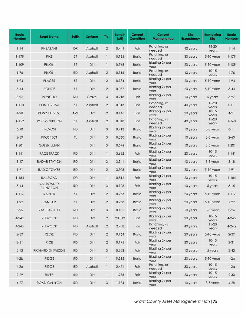
Grant County Asset Management Plan|75
Route
Number Road Name Suffix Surface Tier
Length
(Mi)
Current
Condition
Current
Maintenance
Life
Expectancy
Remaining
Life
Route
Number
1-14 PHEASANT DR Asphalt 2 0.444 Fair Patching, as
needed 40 years
15-20
years 1-14
1-179 PIKE ST Asphalt 1 0.135 Basic Patching, as
needed 30 years 5-10 years 1-179
1-109 PINON ST Dirt 1 0.768 Basic Blading 2x per
year 20 years 5-10 years 1-109
1-76 PINON RD Asphalt 2 0.116 Basic Patching, as
needed 40 years
10-15
years 1-76
1-94 PLACER ST Dirt 2 0.184 Basic Blading 2x per
year 20 years 5-10 years 1-94
3-44 PONCE ST Dirt 2 0.077 Basic Blading 2x per
year 20 years 5-10 years 3-44
3-97 PONCHO RD Gravel 3 0.918 Fair Blading 2x per
year 10 years 5 years 3-97
1-110 PONDEROSA ST Asphalt 2 0.313 Fair Patching, as
needed 40 years
15-20
years 1-111
4-20 PONY EXPRESS AVE Dirt 2 0.146 Fair Blading 2x per
year 20 years
10-15
years 4-21
1-159 POP MORRISON ST Asphalt 2 0.048 Fair Patching, as
needed 40 years
15-20
years 1-160
6-10 PREVOST RD Dirt 3 0.413 Basic Blading 2x per
year 10 years 3-5 years 6-11
2-59 PROSPECT PL Dirt 3 0.060 Basic Blading 2x per
year 10 years 3-5 years 2-60
1-201 QUEEN LILIAN Dirt 3 0.576 Basic Blading 2x per
year 10 years 3-5 years 1-201
1-141 RACE TRACK RD Dirt 1 3.662 Fair Blading 2x per
year 20 years
10-15
years 1-141
5-17 RADAR STATION RD Dirt 3 3.341 Basic Blading 2x per
year 10 years 3-5 years 5-18
1-91 RADIO TOWER RD Dirt 2 3.508 Basic Blading 2x per
year 20 years 5-10 years 1-91
1-184 RAILROAD DR Dirt 1 0.512 Fair Blading 2x per
year 20 years
10-15
years 1-184
3-14 RAILROAD "Y
"JUNCTION RD Dirt 3 0.128 Fair
Blading 2x per
year 10 years 5 years 3-15
1-117 RAINIER ST Dirt 2 0.263 Basic Blading 2x per
year 20 years 5-10 years 1-117
1-92 RANGER ST Dirt 2 0.258 Basic Blading 2x per
year 20 years 5-10 years 1-92
3-25 RAY CASTILLO RD Dirt 3 0.105 Basic Blading 2x per
year 10 years 3-5 years 3-26
4-24b REDROCK RD Dirt 2 20.319 Fair Blading 2x per
year 20 years
10-15
years 4-24b
4-24a REDROCK RD Asphalt 2 2.788 Fair Patching, as
needed 40 years
15-20
years 4-24a
2-39 REESE RD Dirt 2 0.164 Basic Blading 2x per
year 20 years 5-10 years 2-39
2-31 RICE RD Dirt 2 0.195 Fair Blading 2x per
year 20 years
10-15
years 2-31
2-42 RICHARD DINWIDDIE RD Dirt 3 0.323 Fair Blading 2x per
year 10 years 5 years 2-42
1-2b RIDGE RD Dirt 1 9.315 Basic Blading 2x per
year 20 years 5-10 years 1-2b
1-2a RIDGE RD Asphalt 1 2.491 Fair Patching, as
needed 30 years
10-15
years 1-2a
2-29 RIVER RD Dirt 1 1.288 Fair Blading 2x per
year 20 years
10-15
years 2-30
4-27 ROAD CANYON RD Dirt 3 1.174 Basic Blading 2x per
year 10 years 3-5 years 4-28

Grant County Asset Management Plan|76
Route
Number Road Name Suffix Surface Tier
Length
(Mi)
Current
Condition
Current
Maintenance
Life
Expectancy
Remaining
Life
Route
Number
1-73 ROAD RUNNER LN Asphalt 2 0.043 Basic Patching, as
needed 40 years
10-15
years 1-74
4-34 ROBERT MARTIN RD Dirt 3 0.151 Fair Blading 2x per
year 10 years 5 years 4-35
1-122 ROBSON ST Asphalt 2 0.213 Fair Patching, as
needed 40 years
15-20
years 1-122
1-99 ROCK ST Dirt 2 0.138 Basic Blading 2x per
year 20 years 5-10 years 1-99
1-104 RODEO RD Dirt 1 0.685 Basic Blading 2x per
year 20 years 5-10 years 1-104
2-7 ROLAND RAY RICE RD Dirt 3 2.385 Fair Blading 2x per
year 10 years 5 years 2-8
1-101 ROSEDALE RD Asphalt 1 3.669 Fair Patching, as
needed 30 years
10-15
years 1-101
1-70 ROSEWOOD CIR Asphalt 2 0.145 Basic Patching, as
needed 40 years
10-15
years 1-70
3-11 ROY RD Dirt 2 0.066 Basic Blading 2x per
year 20 years 5-10 years 3-12
3-77b ROYAL JOHN MINE RD Dirt 2 8.194 Basic Blading 2x per
year 20 years 5-10 years 3-77b
3-77c ROYAL JOHN MINE RD Dirt 3 3.132 Basic Blading 2x per
year 10 years 3-5 years 3-77c
3-77a ROYAL JOHN MINE RD Asphalt 2 0.767 Basic Patching, as
needed 40 years
10-15
years 3-77a
2-57 RT DR Dirt 2 0.279 Basic Blading 2x per
year 20 years 5-10 years 2-58
1-208 RUN Gravel 3 0.692 Fair Blading 2x per
year 10 years 5 years 1-208
1-216 RUNNING IRON
RIDGE Gravel 3 1.168 Fair
Blading 2x per
year 10 years 5 years 1-216
2-1 SACATON RD Dirt 2 25.115 Basic Blading 2x per
year 20 years 5-10 years 2-2
4-21 SADDLE ROCK
CANYON RD Dirt 2 0.982 Fair
Blading 2x per
year 20 years
10-15
years 4-22
3-53 SAGE DR Dirt 1 0.504 Fair Blading 2x per
year 20 years
10-15
years 3-53
3-17 SAN ANTONIO
CHURCH RD Dirt 3 0.120 Basic
Blading 2x per
year 10 years 3-5 years 3-17
3-39 SAN FRANCISCO ST Asphalt 2 0.848 Basic Patching, as
needed 40 years
10-15
years 3-39
3-43 SAN JOSE ST Dirt 2 0.213 Basic Blading 2x per
year 20 years 5-10 years 3-43
3-76 SAN JUAN CEMETERY RD Dirt 3 0.199 Basic Blading 2x per
year 10 years 3-5 years 3-76
3-40 SAN LORENZO ST Dirt 2 0.102 Basic Blading 2x per
year 20 years 5-10 years 3-40
3-38 SAN YSIDRO ST Dirt 2 0.148 Basic Blading 2x per
year 20 years 5-10 years 3-38
1-48 SANITARIUM RD Dirt 2 0.046 Basic Blading 2x per
year 20 years 5-10 years 1-49
1-166b SANTA RITA MINE RD Asphalt 1 0.422 Basic Patching, as
needed 30 years 5-10 years 1-166b
1-166a SANTA RITA MINE RD Asphalt 2 1.633 Basic Patching, as
needed 30 years 5-10 years 1-166a
1-172 SCHIFF TRL Asphalt 2 0.274 Basic Patching, as
needed 40 years
10-15
years 1-173
6-8a SEPAR RD Dirt 1 1.949 Basic Blading 2x per
year 20 years 5-10 years 6-8a
6-8b SEPAR RD Dirt 2 29.682 Basic Blading 2x per
year 20 years 5-10 years 6-8b

Grant County Asset Management Plan|77
Route
Number Road Name Suffix Surface Tier
Length
(Mi)
Current
Condition
Current
Maintenance
Life
Expectancy
Remaining
Life
Route
Number
1-68 SHADOW MOUNTAIN RD Asphalt 2 0.344 Basic Patching, as
needed 40 years
10-15
years 1-68
1-46 SHALE DR Dirt 2 0.188 Basic Blading 2x per
year 20 years 5-10 years 1-46
1-116 SHASTA ST Dirt 1 0.333 Basic Blading 2x per
year 20 years 5-10 years 1-116
2-25 SHELLEY RD Dirt 3 0.395 Fair Blading 2x per
year 10 years 5 years 2-26
4-28 SHERMAN HARPER RD Dirt 3 1.719 Fair Blading 2x per
year 10 years 5 years 4-29
2-14 SHIELDS CANYON RD Dirt 2 0.470 Fair Blading 2x per
year 20 years
10-15
years 2-15
3-31 SHINGLE CANYON RD Dirt 3 1.945 Basic Blading 2x per
year 10 years 3-5 years 3-32
6-27 SHIPPING PENS RD Dirt 3 2.818 Fair Blading 2x per
year 10 years 5 years 6-28
4-3 SILBY RD Dirt 3 0.269 Fair Blading 2x per
year 10 years 5 years 4-4
3-80 SILVER CREEK RD Dirt 3 5.423 Basic Blading 2x per
year 10 years 3-5 years 3-81
1-195 SILVER SPUR Gravel 2 0.104 Fair Blading 2x per
year 20 years
10-15
years 1-195
1-90 SIX SHOOTER DR Asphalt 2 0.254 Fair Patching, as
needed 51 years
15-20
years 1-90
1-16 SKY VIEW DR Asphalt 2 0.401 Fair Patching, as
needed 40 years
15-20
years 1-16
6-17 SOUTH WELLS RD Dirt 3 4.883 Good Blading 2x per
year 10 years 5-10 years 6-17
6-17 SOUTHWELLS RD Dirt 3 1.508 Basic Blading 2x per
year 10 years 3-5 years 6-17
1-8 SPEAR DR Asphalt 2 0.446 Fair Patching, as
needed 40 years
15-20
years 1-8
1-95 SPRING ST Dirt 2 0.251 Basic Blading 2x per
year 20 years 5-10 years 1-95
1-103 SPRING CREEK RD Dirt 1 0.792 Basic Blading 2x per
year 20 years 5-10 years 1-103
1-88 SPUR DR Dirt 2 0.224 Fair Blading 2x per
year 20 years
10-15
years 1-88
2-38 STAILEY RD Dirt 2 0.383 Fair Blading 2x per
year 20 years
10-15
years 2-38
2-9 STEPHANS RD Dirt 2 0.406 Fair Blading 2x per
year 20 years
10-15
years 2-9
1-173 SULLY CIR Asphalt 2 0.059 Basic Patching, as
needed 40 years
10-15
years 1-174
5-20 SUMMIT PEAK RD Dirt 3 3.614 Basic Blading 2x per
year 10 years 3-5 years 5-21
1-130 SUNSET TRL Dirt 1 0.282 Fair Blading 2x per
year 20 years
10-15
years 1-130
1-86 SWAN ST Asphalt 1 3.677 Fair Patching, as
needed 30 years
10-15
years 1-86
1-113 SYCAMORE ST Asphalt 2 0.413 Fair Patching, as
needed 40 years
15-20
years 1-113
3-2 T & M RD Dirt 2 0.261 Basic Blading 2x per
year 20 years 5-10 years 3-3
1-6b TABOR AVE Dirt 2 0.187 Basic Blading 2x per
year 20 years 5-10 years 1-6b
1-6a TABOR AVE Asphalt 2 0.689 Good Patching, as
needed 40 years
25-30
years 1-6a
1-168 TANGLEWOOD CIR Asphalt 2 0.156 Good Patching, as
needed 40 years
25-30
years 1-169

Grant County Asset Management Plan|78
Route
Number Road Name Suffix Surface Tier
Length
(Mi)
Current
Condition
Current
Maintenance
Life
Expectancy
Remaining
Life
Route
Number
6-14 TAYLOR RD Dirt 2 0.973 Fair Blading 2x per
year 20 years
10-15
years 6-15
3-82 TAYLOR ALLISON RD Dirt 3 0.602 Fair Blading 2x per
year 10 years 5 years 3-82
3-79 TAYLOR GRAHAM RD Dirt 3 0.268 Fair Blading 2x per
year 10 years 5 years 3-79
3-88 TAYLOR MOUNTAIN RD Dirt 3 2.061 Basic Blading 2x per
year 10 years 3-5 years 3-88
5-16 TAYLOR RANCH RD Dirt 3 0.918 Fair Blading 2x per
year 10 years 5 years 5-17
1-35 TENORITE CT Asphalt 1 0.057 Fair Patching, as
needed 30 years
10-15
years 1-36
3-74 TIMBER ST Dirt 2 0.089 Basic Blading 2x per
year 20 years 5-10 years 3-75
2-48 TOM MCCAULEY RD Dirt 3 0.260 Fair Blading 2x per
year 10 years 5 years 2-49
1-13 TOMAHAWK RD Dirt 2 0.291 Fair Blading 2x per
year 20 years
10-15
years 1-14
3-64 TONY GRIJALVA RD Dirt 2 0.116 Fair Blading 2x per
year 20 years
10-15
years 3-65
1-28 TORBERNITE DR Asphalt 1 0.117 Fair Patching, as
needed 30 years
10-15
years 1-28
1-10 TRAILING HEART DR Asphalt 2 0.728 Basic Patching, as
needed 40 years
10-15
years 1-10
2-24 TURKEY CREEK RD Dirt 2 9.890 Basic Blading 2x per
year 20 years 5-10 years 2-25
1-25 TURQUOISE DR Asphalt 1 0.088 Fair Patching, as
needed 30 years
10-15
years 1-25
1-83 TURRIETTS RD Dirt 2 0.095 Basic Blading 2x per
year 20 years 5-10 years 1-83
4-1 TYRONE MINE RD Asphalt 2 0.455 Fair Patching, as
needed 40 years
15-20
years 4-2
6-1 TYRONE RIDGE
ACCESS RD Dirt 2 8.701 Basic
Blading 2x per
year 20 years 5-10 years 6-2
4-2 TYRONE-TOMPSON RD Dirt 2 14.780 Basic Blading 2x per
year 20 years 5-10 years 4-2
4-17 UT DR Dirt 2 0.351 Fair Blading 2x per
year 20 years
10-15
years 4-17
3-85 VALENTINE
DOMINQUEZ RD Dirt 3 0.241 Fair
Blading 2x per
year 10 years 5 years 3-86
1-54 VALLEY DR Dirt 2 0.995 Basic Blading 2x per
year 20 years 5-10 years 1-54
1-211 VENTANA DR Gravel 2 0.259 Fair Blading 2x per
year 20 years
10-15
years 1-211
1-198 VENTANA DE SIERRA Gravel 2 0.796 Fair Blading 2x per
year 20 years
10-15
years 1-198
1-190 VESUVIUS WAY Asphalt 2 0.526 Good Patching, as
needed 40 years
25-30
years 1-190
1-5 VICENTE PL Asphalt 2 0.191 Fair Patching, as
needed 40 years
15-20
years 1-5
1-82 VILLAGE RD Dirt 1 0.396 Fair Blading 2x per
year 20 years
10-15
years 1-82
1-66 W TIMMER WAY Asphalt 2 0.114 Basic Patching, as
needed 40 years
10-15
years 1-66
2-50 WALK BRIDGE
ACCESS RD Dirt 3 0.786 Fair
Blading 2x per
year 10 years 5 years 2-51
4-14 WALKING X RANCH RD Dirt 3 0.506 Basic Blading 2x per
year 10 years 3-5 years 4-15
1-89 WENDY RD Asphalt 2 1.406 Fair Patching, as
needed 40 years
15-20
years 1-89

Grant County Asset Management Plan|79
Route
Number Road Name Suffix Surface Tier
Length
(Mi)
Current
Condition
Current
Maintenance
Life
Expectancy
Remaining
Life
Route
Number
1-22 WESTERN DR Asphalt 2 0.697 Basic Patching, as
needed 40 years
10-15
years 1-22
1-132 WHISKEY CREEK
AIRPORT RD Asphalt 2 0.639 Basic
Patching, as
needed 40 years
10-15
years 1-132
1-71 WHISPERING HILLS RD Asphalt 2 0.575 Basic Patching, as
needed 40 years
10-15
years 1-71
6-5 WHITEWATER RD Dirt 2 19.068 Basic Blading 2x per
year 20 years 5-10 years 6-6
1-185 WILMOT RD Asphalt 2 0.066 Good Patching, as
needed 40 years
25-30
years 1-185
1-207 WIND CANYON RD Gravel 2 2.746 Fair Blading 2x per
year 20 years
10-15
years 1-207
3-30 WINDMILL PASTURE RD Dirt 3 1.478 Basic Blading 2x per
year 10 years 3-5 years 3-31
7-2 WINDMILL RIDGE Gravel 3 0.280 Fair Blading 2x per
year 10 years 5 years 7-3
5-7 Y6 RD Dirt 3 5.365 Fair Blading 2x per
year 10 years 5 years 5-8
3-10 YOUNG RD Dirt 2 0.141 Fair Blading 2x per
year 20 years
10-15
years 3-11
1-149 YUCCA POD LN Dirt 2 0.121 Basic Blading 2x per
year 20 years 5-10 years 1-149
1-150 YUCCA STALK LN Dirt 2 0.180 Basic Blading 2x per
year 20 years 5-10 years 1-150
1-148 YUCCA VALLEY DR Dirt 2 0.512 Basic Blading 2x per
year 20 years 5-10 years 1-148
1-58 ZIA CIR Asphalt 2 0.097 Basic Patching, as
needed 40 years
10-15
years 1-58
3-7 ZINC HILL RD Dirt 2 0.091 Basic Blading 2x per
year 20 years 5-10 years 3-8

Grant County Asset Management Plan|80