granton waterfront - development framework february 2020
TRANSCRIPT

G r a n to N W at e r f r o n t
Development Framework February 2020

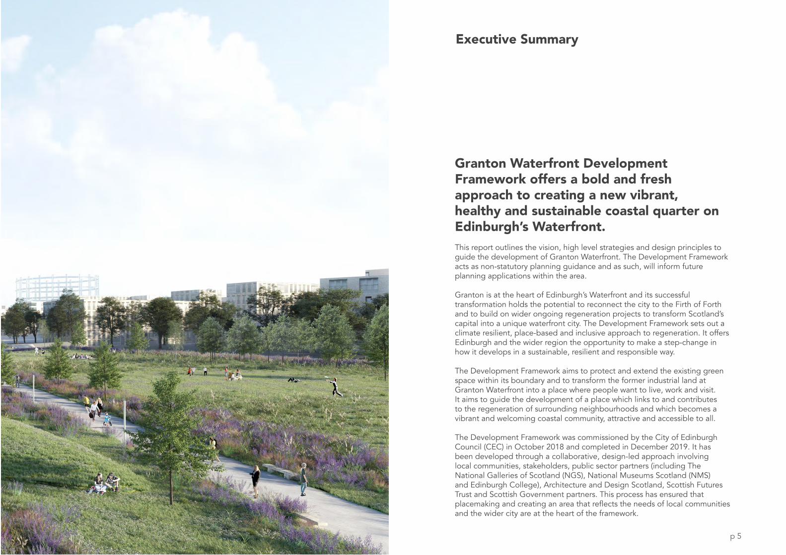
Illustrative view of new sustainable neighbourhood looking towards the waterfront

p 3
Foreword
“Granton has a long and productive heritage, from the towering gas holder that stands firmly on our city’s skyline to Madelvic car factory that sparked innovation as far back as 1898.
Those days are long gone but Granton’s prominence on Edinburgh’s coastline is undiminished and now provides an unmissable opportunity to learn from cities across Europe that celebrate their coastline.
‘Granton Waterfront’ sets out the ambition for a new waterfront quarter that champions low carbon transport, active travel and sustainable development; a quarter that supports the rich natural environment of Edinburgh’s coastline and, crucially, a place that stands the test of time.
It will herald a new approach to urban development and regeneration, providing a blueprint for the future. Cultural hubs, innovation start up space, new jobs for local people and high quality homes are brought together to create a diverse and exciting place rooted in community, fairness and sustainability.
The people of North Edinburgh have long known the amazing asset that is their coastline; something this framework acknowledges and take its inspiration from, setting the principles for Edinburgh to redefine itself as a waterfront city. This renewed approach to the coastline provides an opportunity for growth within Scotland’s vibrant capital city.”
- Counci l lor Adam McVey and Counci l lor Cammy Day.
Councillor Adam McVey(Council Leader)
Councillor Cammy Day(Deputy Council Leader)

Illustrative view of coastal park looking towards the waterfront
p 4
p 5
Granton Waterfront Development Framework offers a bold and fresh approach to creating a new vibrant, healthy and sustainable coastal quarter on Edinburgh’s Waterfront.This report outlines the vision, high level strategies and design principles to guide the development of Granton Waterfront. The Development Framework acts as non-statutory planning guidance and as such, will inform future planning applications within the area.
Granton is at the heart of Edinburgh’s Waterfront and its successful transformation holds the potential to reconnect the city to the Firth of Forth and to build on wider ongoing regeneration projects to transform Scotland’s capital into a unique waterfront city. The Development Framework sets out a climate resilient, place-based and inclusive approach to regeneration. It offers Edinburgh and the wider region the opportunity to make a step-change in how it develops in a sustainable, resilient and responsible way.
The Development Framework aims to protect and extend the existing green space within its boundary and to transform the former industrial land at Granton Waterfront into a place where people want to live, work and visit. It aims to guide the development of a place which links to and contributes to the regeneration of surrounding neighbourhoods and which becomes a vibrant and welcoming coastal community, attractive and accessible to all.
The Development Framework was commissioned by the City of Edinburgh Council (CEC) in October 2018 and completed in December 2019. It has been developed through a collaborative, design-led approach involving local communities, stakeholders, public sector partners (including The National Galleries of Scotland (NGS), National Museums Scotland (NMS) and Edinburgh College), Architecture and Design Scotland, Scottish Futures Trust and Scottish Government partners. This process has ensured that placemaking and creating an area that reflects the needs of local communities and the wider city are at the heart of the framework.
Executive Summary

Commissioned by: City of Edinburgh Council
Agent: Collective Architecture 24 Ainslie Place Edinburgh, EH3 6AJ
Prepared by: Collective Architecture
In association with: Studio for New Realities (Urban Designer) Arup (Energy and Utilities Engineers) Gardiner and Theobald (Quantity Surveyors) LUC (Landscape Architects) AECOM (Transport Engineers, Floods and Ecology Engineers)
Completed by: ....................................................................................... Collective Architecture
Status: FINAL ISSUE
Date: February 2020
Approved by: .......................................................................................
.......................................................................................
Project Partners: City of Edinburgh Council Scottish Futures Trust Edinburgh College National Museums Scotland National Galleries of Scotland Scottish Government
Project Team:
Studiofor NewRealities
p 6

1. Site and Context Page
1.1 The Site 101.2 Policy and Planning Context 161.3 Constraints and Opportunities 20
2. Vision and Principles
2.1 Vision for Granton 242.2 Regional Scale 262.3 City Scale 282.4 Granton Principles 30
3. Development Framework - High Level Strategies
3.1 Development Framework 343.2 Landscape and Public Spaces 38 3.3 Blue-Green Infrastructure 40 3.4 Historic Assets 42 3.5 Connections, Access and Views 443.6 Integrating Public Transport and Active Travel 46 3.7 Vehicular Movement and Parking 50 3.8 Block Structure and Street Frontages 54 3.9 Housing Typologies and Tenure Mix 56 3.10 Heights and Massing 583.11 Proposed New Uses 60 3.12 Sustainability and Energy Strategy 643.13 Refuse Strategy 67
Contents
4. Character Areas
4.1 Character Areas Overview 704.2 Coastal Granton 724.3 Forthquarter Park 744.4 Harbour Road 754.5 Waterfront Broadway 76 4.6 Upper Granton 77 4.7 West Shore 784.8 Existing Neighbourhoods 79 4.9 The Link 80
5. Key Spaces and Interfaces
5.1 Key Spaces and Interfaces Overview 845.2 Key Spaces 86 5.3 Key Streets and Interfaces 90
6. Design Guidelines
6.1 Architectural Guidelines 1026.2 Material Guidelines 1066.3 Street and Amenity Space Guidelines 1086.4 Landscape Guidelines 110
Appendices A2 Supporting Information
p 7

Fig. 1.0: Aerial Photograph of part of Development Framework area looking north west towards the Firth of Forth
p 8

p 9
1 . Site + Context
1.1 The Site1.2 Policy and Planning Context1.3 Constraints and Opportunities
This chapter establishes the physical and strategic context for the development framework.

p 10p 10
Fig. 1.1: Aerial Map showing Development Framework area (consisting of mainly green space and former industrial land) in relation to Edinburgh’s city centre and surrounding neighbourhoods
NEW TOWN
OLD TOWN
Botanic Gardens
HolyroodPark
Calton Hill
Leith
Cramond
Dalmeny
Pennywell
Muirhouse
Silverknowes
PiltonTrinity
Western Harbour
FIRTH OF FORTH
Development Framework area Open green space and parkland
GRANTON
Former Industrial Land
Open Green space and Parkland
1 . 1 The Site

p 11
1 . 1
p 11
The Site
Fig. 1.2: Granton as part of a ’necklace’ of coastal communities, and in relation to Edinburgh city centre
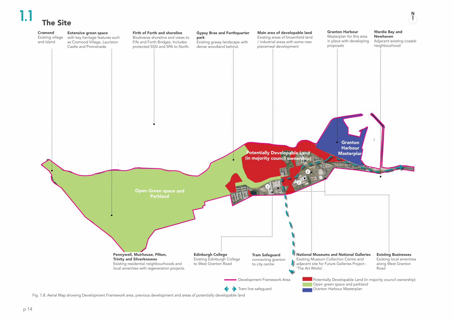
Development Framework AreaGranton Waterfront is situated around 3 miles north of Edinburgh city centre on the shores of the Firth of Forth. It sits in a ’necklace’ of coastal communities and stretches from Cramond in the west along the waterfront to Granton Harbour in the east, (Fig. 1.2). It also connects to the surrounding communities of Pennywell, Muirhouse, Pilton, Trinity and Newhaven. The site comprises around 200 hectares of open green space and parkland (to the west) and around 50 hectares of potentially developable former industrial land that is not currently subject to other planning conditions (to the centre and east). The location and extent of the Development Framework is shown below and opposite via the pink line boundary, (Fig. 1.1).
The Development Framework sets out a vision and principles for the entire framework area and provides an urban design framework and design guidelines for the potentially developable land in the centre and east of the site.
GRANTON
LEITH
PORTOBELLO
MUSSELBURGH
CRAMOND
EDINBURGH CITY CENTRE
COCKENZIE

p 12
The Site
1752Fig. 1.3: Pre-industrial Granton was home to very few people, instead the land was mainly open green fields used for farming or grazing animals. Unlike other coastal towns on the waterfront there was no historic settlements other than some large country houses such as Caroline Park.
1920Fig. 1.5: At the beginning of the 20th century much of Granton was still used to grow food to supply Edinburgh and Leith. Alongside this, the gas works opened in 1903. After WWI the boundaries of Edinburgh were expanded to take in the whole of Granton.
1955Fig. 1.6: The amalgamation of Granton with Edinburgh coincided with new legislation which made the construction of local authority housing easier. By the post-war period Granton had developed to include dense housing, industry, shopping and transport links.
1885Fig. 1.4: The structure of industrial Granton was now emerging; the harbour had been constructed in 1838; the railway had arrived; housing for workers along Lower Granton Road had been constructed; and Granton Square and Granton Road were constructed.
1 . 1

p 13
The Site
HistoryMuch of the former industrial land was used for the production and storage of gas and other industrial processes. Many remnants of this important industrial heritage remain, including one of the three gas holders and the associated railway station building. Important historic assets also remain, including Caroline Park House, the Lighthouse and the UK’s first electric car factory, the Madelvic.
In the late 20th Century, the gasworks site and adjoining industrial sites were made available for redevelopment. The area was subsequently subject to numerous masterplan design proposals. Some of these have been implemented in part, however, none were ever fully delivered. Regeneration projects in the early 2000’s cleared large areas of former industrial land and established the main pedestrian and vehicle routes through the site. Some major developments were built including the British Gas HQ, Edinburgh College, Forthquarter Park and approx 1400 residential units. However, development stalled around 2007 and as a result, large undeveloped areas of former industrial land with poor connectivity remain. Public access to key areas of the waterfront itself remains blocked by industrial units. The maps opposite (Fig. 1.3-1.7)illustrate how Granton Waterfront has evolved from the 1750’s up 2018.
2018Fig. 1.7: Moving into the 21st Century sees much of this industry closed and most of the harbour having been in-filled. However, the waterfront and various heritage and cultural assets remain as evidence of the areas rich history.
1 . 1
p 14
Fig. 1.8: Aerial Map showing Development Framework area, previous development and areas of potentially developable land
Cramond
Pennywell
Muirhouse
Silverknowes
Pilton
Granton Harbour
Masterplan
Open Green space and Parkland
Firth of Forth
Trinity
Waride Bay
Tram Safeguard connecting granton to city centre
Edinburgh CollegeExisting Edinburgh College to West Granton Road
Existing Businesses Existing local amenities along West Granton Road
National Museums and National GalleriesExisting Museum Collection Centre and adjacent site for Future Galleries Project - ‘The Art Works’.
23
4
Potentially Developable Land (in majority council ownership)Open green space and parklandGranton Harbour Masterplan
Development Framework Area Tram line safeguard
1
Pennywell, Muirhouse, Pilton, Trinity and SilverknowesExisting residential neighbourhoods and local amenities with regeneration projects.
1 . 1Granton Harbour Masterplan for this area in place with developing proposals
Gypsy Brae and Forthquarter parkExisting grassy landscape with dense woodland behind.
Firth of Forth and shorelineBiodiverse shoreline and views to Fife and Forth Bridges. Includes protected SSSI and SPA to North.
Main area of developable landExisting areas of brownfield land / industrial areas with some new piecemeal development
CramondExisting village and island
Wardie Bay and NewhavenAdjacent existing coastal neighbourhood
Extensive green spacewith key heritage features such as Cramond Village, Lauriston Castle and Promenade
The Site
Potentially Developable Land (in majority council ownership)

p 15
The Site
Developable LandThe Council now own around 50 hectares of land within the Granton Waterfront site, identified in red on Fig. 1.8, opposite. The regeneration of this area will provide for new homes of varying tenure, a new primary school, healthcare centre, small scale leisure and retail opportunities, links with new and existing cultural facilities, business/enterprise ‘start-ups’ and creative space, tied together with a high-quality public realm and diverse green spaces. Together these will reconnect new and existing neighbourhoods to the wider city and the waterfront, creating a vibrant, healthy and sustainable coastal quarter on Edinburgh’s Waterfront.
Existing and Planned DevelopmentWithin the framework boundary there are a number of existing communities and sites which have been developed or have exciting new development planned on them. (For ownership see Appendix A2.1 - Ownership and other development projects). In light of this, the Framework has been developed in dialogue with a series of key public sector partners, stakeholders and existing communities. A Record of Engagement has been prepared to accompany this report. (See Appendix A2.2 for a summary). Reference should be made to this to ensure that future applications respond appropriately to the broad range of needs identified through the engagement process.
Project PartnersThe following key public sector partners have sites or plans in the area and have been involved in the Framework since inception: The National Museums Scotland (NMS), National Galleries of Scotland (NGS) and Edinburgh College.These national cultural and educational institutions are a key part of the Development Framework and should play a central role in the future holistic regeneration of Granton Waterfront, (See also p.80 and Appendix A2.7 for further detail).
Other StakeholdersAlongside these public sector partners there are a number of other parties working or established in the area, including the owners of Granton Harbour, housing already under construction and a number of existing residential, commercial, social enterprise and community uses. A safeguarded tram route also runs through the site. Fig. 1.8, illustrates the location of some of the site’s assets and Fig.1.9-1.12 (left) summarises some of the current development ambitions.
1 . 1
3 Edinburgh CollegeFig. 1.11: Edinburgh College has been a central part of Granton for many years. The college has ambitions to open out the campus, both physically and socially, into the wider area. There is also ambition to provide a new Construction Skills Centre - which champions modern construction skills and provides enterprise and community facilities in the area.
1 Granton HarbourFig. 1.9: a separate masterplan is in place for Granton Harbour which sets to transform the former industrial land into a mixed-use waterside development centred around a new marina.
2 National Museums Collection CentreFig. 1.10: The NMS Collections Centre has been based in Granton since 1993. It provides storage space for Scotland’s National Collection and facilities for international research and conservation. It has ambitions to further invest in the site to encourage opportunities for community connectivity and access.
4 ‘The Art Works’ - NGSFig. 1.12: The National Galleries of Scotland have been developing proposals for a new facility based in Granton called: ‘The Art Works.’ This community based facility will be open to everyone and designed to hold and care for the nation’s treasures. (Note, this facility was previously known as the National Collection Facility)
p 16
Edinburgh’s Economic Strategy
EDINBURGH ECONOMY STRATEGY ENABLING GOOD GROWTH
JUNE 2018
Policy and Planning Context
Relevant Policy and Guidance Relevant Policy and GuidanceGranton Waterfront DF response Granton Waterfront DF response
City Mobility Plan and citywide Low Emission Zones
Sustainability Approach
Corporate Policy and Strategy Meeting
10.00am, Tuesday, 14 May 2019
Sustainability Approach
Executive/routine Wards Council Commitments
1. Recommendations
1.1 That the Committee:
1.1.1 agrees the importance of sustainability and climate change to the health, wellbeing and prosperity of the city of Edinburgh and its current and future citizens.
1.1.2 agrees the proposed Council carbon target of working towards a net zero carbon target by 2030, with a hard target of 2037, which takes forward the February Council ‘Climate Emergency’ Motion.
1.1.3 endorses the three-phased delivery plan for responding to the Kerr Audit and the recommendations agreed by the Committee in February.
1.1.4 agrees to the proposed approach to developing a sustainability programme plan and monitoring framework, which will consolidate the sustainability work of the Council; transparently measure its impact; and identify any gaps.
1.1.5 agrees the route map for developing the 2030 Sustainability Strategy and 2050 Ambition and endorses the focus on a city-wide plan and long-term ambition that is co-produced with new and established partners across Edinburgh.
1.1.6 notes the establishment of an Officer Sustainability Programme Board and its proposed remit.
1.1.7 agrees the dissolution of the Carbon, Climate and Sustainability working group and the establishment of the ‘Sustainability All Party Oversight Group’ and its proposed remit.
1.1.8 notes the resourcing arrangements and implications going forward.
Edinburgh Promenade Design Code
Edinburgh Design Guidance
Edinburgh Design GuidanceOctober 2017
Amended November 2018
• The Place Standard Tool was used to structure the extensive engagement programme with local community members, stakeholders and Scottish government undertaken as part of the Development Framework process.
• The Vision, Principles and Development Framework outlined in this document establish guidelines to ensure that future development follows a placemaking approach.
Place Standard
• The Framework allows for the continuation of the Edinburgh Promenade project through the Granton Waterfront area.
• The proposals for a new coastal park and routes along the waterfront align with the key design principles and character areas outlined in the design code.
• All detailed proposals within the Development Framework area should also take account of the guidance within the Edinburgh Design Guidance document.
• The high-level strategies, character areas and design guidance for key public streets and spaces set out in chapters 3-6 of the Development Framework accord with this.
• The principles and approach described within the Development Framework support the City of Edinburgh Council’s commitment to work towards a net zero carbon target by 2030.
• Energy, transport, landscape and water management specialists contributed to the development of the framework to ensure a holistic and innovative approach to sustainability was taken throughout.
• The transport strategy for Granton Waterfront reflects the ambitions identified in the developing City Mobility Plan. The strategy supports modal shifts away from the car in favour of sustainable modes to lessen harmful emissions and bring benefits both environmentally and to health and wellbeing.
• This approach also supports Scottish government and CEC targets for the development of Low Emission Zones across the city of Edinburgh.
• Granton Waterfront’s ambition is to go beyond current policy and guidance by surpassing targets through the provision of multi modal travel choices with a preference towards low carbon travel options.
• The regeneration of Granton Waterfront as per the vision and principles outlined in the Development Framework aligns with the eight steps described in Edinburgh’s economic strategy - Enabling good growth.
• The collaborative approach to developing the framework with local communities and project partners supports the strategy vision to be inclusive and prioritise collaboration.
1 .2

p 17
Fig. 1.13: Extract from 2016 Edinburgh Local Development Plan (LDP) which identifies Granton and Edinburgh’s Waterfront as a Strategic Development Area and new development zone
1 .2
p 17
Policy and Planning Context
The Development Framework accords with aspirations set out in current national and local policy, including:
• The emerging themes of the City Vision 2050,
• Edinburgh’s Economic Strategy,
• Edinburgh Local Development plan,
• City of Edinburgh Council’s (CEC) commitment to be zero carbon by 2030,
• The Place Standard,
• A series of key coastline and sustainability initiatives, most notably the Edinburgh Shoreline Project and Edinburgh Promenade project,
• Edinburgh Design Guidance,
• Edinburgh’s Open Space Strategy (2016),
• City Mobility plan and low emission zones (under development) and
• The Edinburgh Local Development Plan (2016), which identifies Granton and Edinburgh’s Waterfront as a Strategic Development area with major new development, (Fig.1.13).
The page opposite outlines some of these key policy documents and how the Development Framework responds to these.
City Vision • The Development Framework, Vision and Granton Principles within this report offers Edinburgh and the wider region the opportunity to mark a step-change in how it develops in a sustainable, resilient and responsible way. This is in keeping with the emerging themes of the City Vision: becoming carbon neutral, eradicating poverty, re-imagining public space and making Edinburgh more caring.

p 18
Forth Quarter
Description: Housing-led mixed use development on land primarily owned by National Grid.
Development Principles:• Complete the approved street layout and
perimeter block urban form• Provide housing-led development on sites
formerly identified for major business-led development
• Provide a housing mix that is appropriate• To the site in terms of place-making and
would maximise completions within this urban regeneration proposal within the plan period
• Deliver school provision as specified in the Action Programme
• Provide a strategic flood risk assessment
Table 11 Edinburgh Waterfront Development Principles
Granton Waterfront
Reference: EW 2a
Location: Forth Quarter
Description: Housing-led mixed use development on land primarily owned by National Grid. An approved master plan has been partly implemented, with several housing blocks, a major office development, a college and a new large park. A proposed new Local Centre to meet the convenience shopping needs or local residents and workers has been delivered in the form of a large foodstore. Additional housing capacity is now available on land formerly designated as part of a strategic business centre.
Development Principles
Proposals will be expected to:
• complete the approved street layout and perimeter block urban form
• provide housing-led development on sites formerly identified for major business-led development
• provide a housing mix that is appropriate to the site in terms of place-making and would maximise completions within this urban regeneration proposal within the plan period
• deliver school provision as specified in the Action Programme
• provide a strategic flood risk assessment
Reference: EW 2b
Location: Central Development Area
Description: Housing-led mixed use development on land assembled by a joint-venture regeneration company. Some housing development has been completed along a new avenue in accordance with an approved master plan. Additional housing capacity is now available on land formerly designated as part of a strategic business centre.
Development Principles
Proposals will be expected to:
• complete the approved street layout and perimeter block urban form
• provide housing-led development on sites formerly identified for major business-led development
• provide a housing mix that is appropriate to the site in terms of place-making and would maximise completions within this urban regeneration proposal within the plan period
• deliver school provision as specified in the Action Programme
• expressly encourage the enhancement of employment and a ‘destination’ through existing and new commercial, cultural, tourist and retail opportunities
• provide a strategic flood risk assessment.Indicative only - not part of the Proposals Map
Indicative only - not part of the Proposals Map
Housing-led mixed use development
Commercial-led mixed use
Business & Industry area
New green space
Cultural use or housing led regeneration
Cycle/footpath safeguarded route
New major streets
Tram line safeguard
School safeguardS
52
Edinburgh Local Development Plan November 2016
Part 1 Section 5 - A Plan for All Parts of the City
Fig. 1.14: Edinburgh Local Development Plan (LDP) 2016 - Extracts and principles relating directly to Granton Development Framework
Central Development Area
Description: Housing-led mixed use development on land assembled by a joint-venture regeneration company.
Development Principles:• Complete the approved street layout and
perimeter block urban form• Provide housing-led development on sites
formerly identified for major business-led development provide a housing mix that is appropriate to the site in terms of place-making and would maximise completions within this urban regeneration proposal within the
• Plan period• Deliver school provision as specified in the Action
Programme• Expressly encourage the enhancement of
employment and a ‘destination’ through existing and new commercial, cultural, tourist and retail opportunities
• Provide a strategic flood risk assessment
Table 11 Edinburgh Waterfront Development Principles
Granton Waterfront
Reference: EW 2a
Location: Forth Quarter
Description: Housing-led mixed use development on land primarily owned by National Grid. An approved master plan has been partly implemented, with several housing blocks, a major office development, a college and a new large park. A proposed new Local Centre to meet the convenience shopping needs or local residents and workers has been delivered in the form of a large foodstore. Additional housing capacity is now available on land formerly designated as part of a strategic business centre.
Development Principles
Proposals will be expected to:
• complete the approved street layout and perimeter block urban form
• provide housing-led development on sites formerly identified for major business-led development
• provide a housing mix that is appropriate to the site in terms of place-making and would maximise completions within this urban regeneration proposal within the plan period
• deliver school provision as specified in the Action Programme
• provide a strategic flood risk assessment
Reference: EW 2b
Location: Central Development Area
Description: Housing-led mixed use development on land assembled by a joint-venture regeneration company. Some housing development has been completed along a new avenue in accordance with an approved master plan. Additional housing capacity is now available on land formerly designated as part of a strategic business centre.
Development Principles
Proposals will be expected to:
• complete the approved street layout and perimeter block urban form
• provide housing-led development on sites formerly identified for major business-led development
• provide a housing mix that is appropriate to the site in terms of place-making and would maximise completions within this urban regeneration proposal within the plan period
• deliver school provision as specified in the Action Programme
• expressly encourage the enhancement of employment and a ‘destination’ through existing and new commercial, cultural, tourist and retail opportunities
• provide a strategic flood risk assessment.Indicative only - not part of the Proposals Map
Indicative only - not part of the Proposals Map
Housing-led mixed use development
Commercial-led mixed use
Business & Industry area
New green space
Cultural use or housing led regeneration
Cycle/footpath safeguarded route
New major streets
Tram line safeguard
School safeguardS
52
Edinburgh Local Development Plan November 2016
Part 1 Section 5 - A Plan for All Parts of the City
North Shore
Description: Area identified for housing-led mixed use development in an approved masterplan.
Development Principles:• Be compatible with future residential development
in Forth Quarter and the Central Development Area
• Complete the relevant section of the waterside Edinburgh Promenade
• Avoid prejudicing future housing-led redevelopment on their sites or on adjacent land
• Provide a strategic flood risk assessment.
Housing-led mixed use development
Commercial-led mixed use
Business & Industry area
New green space
Cycle/footpath safeguarded route
New major streets
Tram line safeguard
School safeguardS
Table 11 Edinburgh Waterfront Development Principles
Granton Waterfront (continued)
Reference: EW 2c
Location: Granton Harbour
Description: Housing-led mixed use development on land owned by Forth Ports Limited and others. Some housing development has been completed in accordance with an approved master plan.
Development Principles
Proposals will be expected to:
• complete the approved street layout and perimeter block urban form
• provide a housing mix that is appropriate to the site in terms of place-making and would maximise completions within this urban regeneration proposal within the plan period
• meet the convenience shopping needs of new and future residents by implementing the proposed Local Centre (Proposed S2)
• complete the relevant section of the waterside Edinburgh Promenade
• provide for retained and improved mooring facilities and boat storage and retain Middle Pier as a ‘working pier’
• include tourism and waterfront-related leisure and entertainment uses
• provide a strategic flood risk assessment.
Reference: EW 2d
Location: North Shore
Description: Area identified for housing-led mixed use development in an approved master plan. However, the slower pace of development in the waterfront means that the North Shore area is unlikely to be available for residential development within the first half of this LDP period. Temporary consents for light industrial development would allow productive use of this area and address the small business needs targeted by Policy Emp 9 without prejudicing residential amenity in new development to the south.
Development Principles
Proposals will be expected to:
• be compatible with future residential development in Forth Quarter and the Central Development Area
• complete the relevant section of the waterside Edinburgh Promenade
• avoid prejudicing future housing-led redevelopment on their sites or on adjacent land
• provide a strategic flood risk assessment.
Indicative only - not part of the Proposals Map
Indicative only - not part of the Proposals Map
53
Edinburgh Local Development Plan November 2016
Part 1 Section 5 - A Plan for All Parts of the City
Granton Harbour
Description: Housing-led mixed use development on land owned by Forth Ports Limited and others.
Development Principles:• Complete the approved street layout and
perimeter block urban form• Provide a housing mix that is appropriate to
the site in terms of place-making and would maximise completions within this urban regeneration proposal within the plan period
• Meet the convenience shopping needs of new and future residents by implementing the proposed Local Centre (Proposed S2)
• Complete the relevant section of the waterside Edinburgh Promenade
• Provide for retained and improved mooring facilities and boat storage and retain Middle Pier as a ‘working pier’
• Include tourism and waterfront-related leisure and entertainment uses
• Provide a strategic flood risk assessment.
Housing-led mixed use development
Commercial-led mixed use
Business & Industry area
New green space
Cycle/footpath safeguarded route
New major streets
Tram line safeguard
School safeguardS
Table 11 Edinburgh Waterfront Development Principles
Granton Waterfront (continued)
Reference: EW 2c
Location: Granton Harbour
Description: Housing-led mixed use development on land owned by Forth Ports Limited and others. Some housing development has been completed in accordance with an approved master plan.
Development Principles
Proposals will be expected to:
• complete the approved street layout and perimeter block urban form
• provide a housing mix that is appropriate to the site in terms of place-making and would maximise completions within this urban regeneration proposal within the plan period
• meet the convenience shopping needs of new and future residents by implementing the proposed Local Centre (Proposed S2)
• complete the relevant section of the waterside Edinburgh Promenade
• provide for retained and improved mooring facilities and boat storage and retain Middle Pier as a ‘working pier’
• include tourism and waterfront-related leisure and entertainment uses
• provide a strategic flood risk assessment.
Reference: EW 2d
Location: North Shore
Description: Area identified for housing-led mixed use development in an approved master plan. However, the slower pace of development in the waterfront means that the North Shore area is unlikely to be available for residential development within the first half of this LDP period. Temporary consents for light industrial development would allow productive use of this area and address the small business needs targeted by Policy Emp 9 without prejudicing residential amenity in new development to the south.
Development Principles
Proposals will be expected to:
• be compatible with future residential development in Forth Quarter and the Central Development Area
• complete the relevant section of the waterside Edinburgh Promenade
• avoid prejudicing future housing-led redevelopment on their sites or on adjacent land
• provide a strategic flood risk assessment.
Indicative only - not part of the Proposals Map
Indicative only - not part of the Proposals Map
53
Edinburgh Local Development Plan November 2016
Part 1 Section 5 - A Plan for All Parts of the City
KEY
Housing-led mixed use developmentCommercial-led mixed useBusiness and Industry useNew green spaceCultural use or housing led regeneration
Table 11 Edinburgh Waterfront Development Principles
Granton Waterfront
Reference: EW 2a
Location: Forth Quarter
Description: Housing-led mixed use development on land primarily owned by National Grid. An approved master plan has been partly implemented, with several housing blocks, a major office development, a college and a new large park. A proposed new Local Centre to meet the convenience shopping needs or local residents and workers has been delivered in the form of a large foodstore. Additional housing capacity is now available on land formerly designated as part of a strategic business centre.
Development Principles
Proposals will be expected to:
• complete the approved street layout and perimeter block urban form
• provide housing-led development on sites formerly identified for major business-led development
• provide a housing mix that is appropriate to the site in terms of place-making and would maximise completions within this urban regeneration proposal within the plan period
• deliver school provision as specified in the Action Programme
• provide a strategic flood risk assessment
Reference: EW 2b
Location: Central Development Area
Description: Housing-led mixed use development on land assembled by a joint-venture regeneration company. Some housing development has been completed along a new avenue in accordance with an approved master plan. Additional housing capacity is now available on land formerly designated as part of a strategic business centre.
Development Principles
Proposals will be expected to:
• complete the approved street layout and perimeter block urban form
• provide housing-led development on sites formerly identified for major business-led development
• provide a housing mix that is appropriate to the site in terms of place-making and would maximise completions within this urban regeneration proposal within the plan period
• deliver school provision as specified in the Action Programme
• expressly encourage the enhancement of employment and a ‘destination’ through existing and new commercial, cultural, tourist and retail opportunities
• provide a strategic flood risk assessment.Indicative only - not part of the Proposals Map
Indicative only - not part of the Proposals Map
Housing-led mixed use development
Commercial-led mixed use
Business & Industry area
New green space
Cultural use or housing led regeneration
Cycle/footpath safeguarded route
New major streets
Tram line safeguard
School safeguardS
52
Edinburgh Local Development Plan November 2016
Part 1 Section 5 - A Plan for All Parts of the City
Cycle / footpath safeguarded routeNew major streetsTram line safeguardSchool safeguard
Table 11 Edinburgh Waterfront Development Principles
Granton Waterfront
Reference: EW 2a
Location: Forth Quarter
Description: Housing-led mixed use development on land primarily owned by National Grid. An approved master plan has been partly implemented, with several housing blocks, a major office development, a college and a new large park. A proposed new Local Centre to meet the convenience shopping needs or local residents and workers has been delivered in the form of a large foodstore. Additional housing capacity is now available on land formerly designated as part of a strategic business centre.
Development Principles
Proposals will be expected to:
• complete the approved street layout and perimeter block urban form
• provide housing-led development on sites formerly identified for major business-led development
• provide a housing mix that is appropriate to the site in terms of place-making and would maximise completions within this urban regeneration proposal within the plan period
• deliver school provision as specified in the Action Programme
• provide a strategic flood risk assessment
Reference: EW 2b
Location: Central Development Area
Description: Housing-led mixed use development on land assembled by a joint-venture regeneration company. Some housing development has been completed along a new avenue in accordance with an approved master plan. Additional housing capacity is now available on land formerly designated as part of a strategic business centre.
Development Principles
Proposals will be expected to:
• complete the approved street layout and perimeter block urban form
• provide housing-led development on sites formerly identified for major business-led development
• provide a housing mix that is appropriate to the site in terms of place-making and would maximise completions within this urban regeneration proposal within the plan period
• deliver school provision as specified in the Action Programme
• expressly encourage the enhancement of employment and a ‘destination’ through existing and new commercial, cultural, tourist and retail opportunities
• provide a strategic flood risk assessment.Indicative only - not part of the Proposals Map
Indicative only - not part of the Proposals Map
Housing-led mixed use development
Commercial-led mixed use
Business & Industry area
New green space
Cultural use or housing led regeneration
Cycle/footpath safeguarded route
New major streets
Tram line safeguard
School safeguardS
52
Edinburgh Local Development Plan November 2016
Part 1 Section 5 - A Plan for All Parts of the City
Policy and Planning Context1 .2
p 19
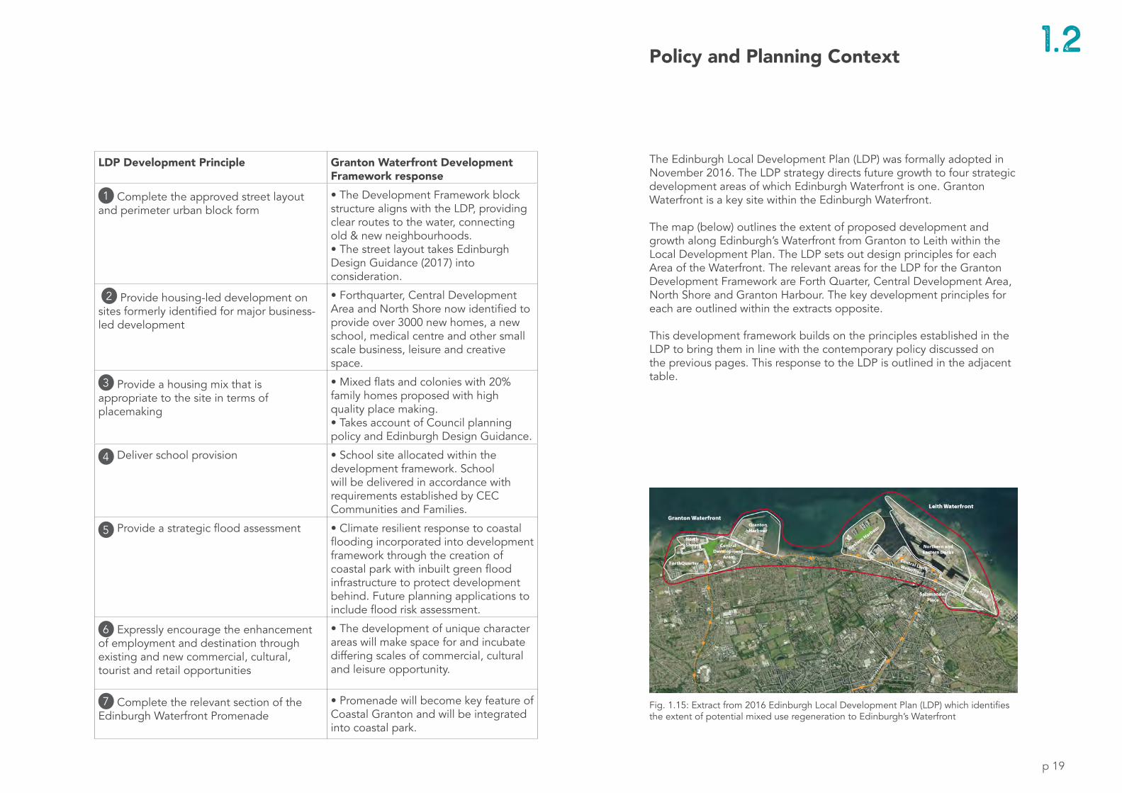
1 .2Policy and Planning Context
The Edinburgh Local Development Plan (LDP) was formally adopted in November 2016. The LDP strategy directs future growth to four strategic development areas of which Edinburgh Waterfront is one. Granton Waterfront is a key site within the Edinburgh Waterfront.
The map (below) outlines the extent of proposed development and growth along Edinburgh’s Waterfront from Granton to Leith within the Local Development Plan. The LDP sets out design principles for each Area of the Waterfront. The relevant areas for the LDP for the Granton Development Framework are Forth Quarter, Central Development Area, North Shore and Granton Harbour. The key development principles for each are outlined within the extracts opposite. This development framework builds on the principles established in the LDP to bring them in line with the contemporary policy discussed on the previous pages. This response to the LDP is outlined in the adjacent table.
LDP Development Principle Granton Waterfront Development Framework response
1 Complete the approved street layout and perimeter urban block form
• The Development Framework block structure aligns with the LDP, providing clear routes to the water, connecting old & new neighbourhoods. • The street layout takes Edinburgh Design Guidance (2017) into consideration.
2 Provide housing-led development on sites formerly identified for major business-led development
• Forthquarter, Central Development Area and North Shore now identified to provide over 3000 new homes, a new school, medical centre and other small scale business, leisure and creative space.
3 Provide a housing mix that is appropriate to the site in terms of placemaking
• Mixed flats and colonies with 20% family homes proposed with high quality place making.• Takes account of Council planning policy and Edinburgh Design Guidance.
4 Deliver school provision • School site allocated within the development framework. School will be delivered in accordance with requirements established by CEC Communities and Families.
5 Provide a strategic flood assessment • Climate resilient response to coastal flooding incorporated into development framework through the creation of coastal park with inbuilt green flood infrastructure to protect development behind. Future planning applications to include flood risk assessment.
6 Expressly encourage the enhancement of employment and destination through existing and new commercial, cultural, tourist and retail opportunities
• The development of unique character areas will make space for and incubate differing scales of commercial, cultural and leisure opportunity.
7 Complete the relevant section of the Edinburgh Waterfront Promenade
• Promenade will become key feature of Coastal Granton and will be integrated into coastal park.
Fig. 1.15: Extract from 2016 Edinburgh Local Development Plan (LDP) which identifies the extent of potential mixed use regeneration to Edinburgh’s Waterfront

p 20
Sun Path
Firth of Forth
Granton HarbourArea under private ownership. Development underway.
Existing Communities
Forthquarter Park
Edinburgh College
National MuseumsScotland
National Gal leries of
Scotland
West Granton Access Rd
West Granton Road
Quarry
Gypsy Brae
Gas holder Station
Bui lding
Waterfront Avenue
West Shore Road
Coastal FloodingArea identified as at risk from coastal flooding
Protected Open Space and greenbelt.Area to west identified as protected open space
Transport connectionsPotential to enhance active travel and public transport options.
Protected Special Area (SPA) and Site of Special Scientific Interest (SSSI) to the north of the site
Former Industrial landLarge areas of former industrial land now vacant across site.
Sloped TopographyAreas with notable steep gradients.
Utilities InfrastructureSignificant utilities routes cross the site.
North-Facing SlopeSite slopes away from sun towards the sea.
Fig. 1.16: Aerial sketch of Development Framework area highlighting key aspects of site ( looking north east towards the Firth of Forth)
Constraints and Opportunities1 .3
p 21
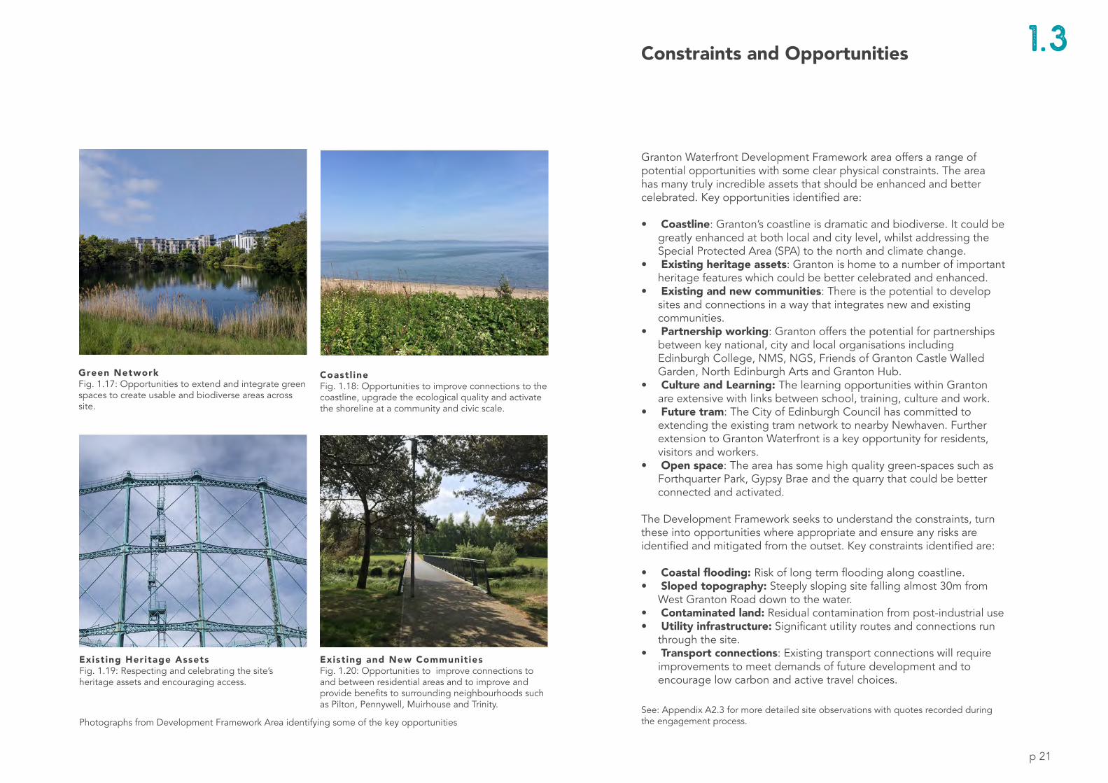
Granton Waterfront Development Framework area offers a range of potential opportunities with some clear physical constraints. The area has many truly incredible assets that should be enhanced and better celebrated. Key opportunities identified are:
• Coastline: Granton’s coastline is dramatic and biodiverse. It could be greatly enhanced at both local and city level, whilst addressing the Special Protected Area (SPA) to the north and climate change.
• Existing heritage assets: Granton is home to a number of important heritage features which could be better celebrated and enhanced.
• Existing and new communities: There is the potential to develop sites and connections in a way that integrates new and existing communities.
• Partnership working: Granton offers the potential for partnerships between key national, city and local organisations including Edinburgh College, NMS, NGS, Friends of Granton Castle Walled Garden, North Edinburgh Arts and Granton Hub.
• Culture and Learning: The learning opportunities within Granton are extensive with links between school, training, culture and work.
• Future tram: The City of Edinburgh Council has committed to extending the existing tram network to nearby Newhaven. Further extension to Granton Waterfront is a key opportunity for residents, visitors and workers.
• Open space: The area has some high quality green-spaces such as Forthquarter Park, Gypsy Brae and the quarry that could be better connected and activated.
The Development Framework seeks to understand the constraints, turn these into opportunities where appropriate and ensure any risks are identified and mitigated from the outset. Key constraints identified are:
• Coastal flooding: Risk of long term flooding along coastline.• Sloped topography: Steeply sloping site falling almost 30m from
West Granton Road down to the water.• Contaminated land: Residual contamination from post-industrial use • Utility infrastructure: Significant utility routes and connections run
through the site.• Transport connections: Existing transport connections will require
improvements to meet demands of future development and to encourage low carbon and active travel choices.
Photographs from Development Framework Area identifying some of the key opportunities
Coastl ineFig. 1.18: Opportunities to improve connections to the coastline, upgrade the ecological quality and activate the shoreline at a community and civic scale.
Existing and New CommunitiesFig. 1.20: Opportunities to improve connections to and between residential areas and to improve and provide benefits to surrounding neighbourhoods such as Pilton, Pennywell, Muirhouse and Trinity.
Existing Heritage AssetsFig. 1.19: Respecting and celebrating the site’s heritage assets and encouraging access.
Green NetworkFig. 1.17: Opportunities to extend and integrate green spaces to create usable and biodiverse areas across site.
Constraints and Opportunities 1 .3
See: Appendix A2.3 for more detailed site observations with quotes recorded during the engagement process.

Fig. 2.0: Aerial image of Granton Waterfront, 2018, from Edinburgh Shoreline project video
p 22

p 23
2. Vision + Principles
2.1 Vision for Granton2.2 Regional Scale2.3 City Scale2.4 Granton Principles
Setting out a Vision for Granton at a local and global level.

GLOBALLOCALOffers a bold and fresh approach to city living.
Gives the coastline back to the city and its people.
Creates one of Europe’s largest natural coastal parks stretching from Lauriston Castle to Wardie Bay.
Positively faces the need for climate resilience.
Takes a low carbon approach in line with UN sustainable goals.
Embraces unique blue-green opportunities.
Sets an aspirational approach to how Edinburgh will evolve in the future.
A coastal community at the heart of the region.
A vibrant, healthy and sustainable coastline.
A place where people want to work, live, learn and visit.
Connects people to the coastline and forms an integral part of the city.
Linked to, and contributes towards, the regeneration of surrounding communities.
Safe and pleasant streets which prioritise walking and cycling.
A place which invites entrepreneurship, makes space for nature and prioritises innovation and sustainable living.
Vision for Granton2.1
p 24

p 25
2.1Vision for Granton
Granton Waterfront is imagined as a vibrant and welcoming coastal community, attractive and accessible to all. The vision for Granton is summarised on the page opposite. It is a vision that works locally and city wide addressing grass roots challenges and global issues.
Granton will set high ambitions to be transformational in a way that benefits residents, surrounding communities and visitors to the area.
Granton will be a distinctive coastal community that is well connected by a green network, active travel routes and provides a diversity of experience.
Granton will be a driver for new activities, business and innovation. It will enhance the local economy, provide anchor destinations and create cultural and learning opportunities.
Granton will offer a new urban approach that provides a diversity of uses centred around its rich ecological landscape. Fig. 2.1: Illustrative 3D sketch of Granton Waterfront Development Framework
p 26
Regional Scale
Fig. 2.2 Regional Granton - potential Forth strategy map
2.2

p 27
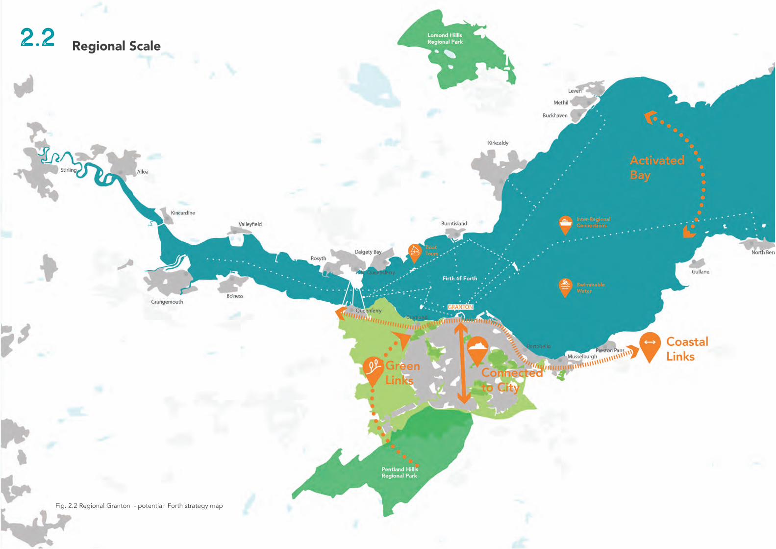
2.2Regional Scale
A Coastal Community at the Heart of the Region The vision for Granton Waterfront involves repositioning Granton as a coastal community at the heart of the region. This provides a key shift in perspective from it being a neighbourhood on the periphery of Edinburgh to it being a neighbourhood central to the Firth of Forth region. With applied 21st Century thinking around urban design, innovation, climate resilience and ecology the area can become a central part of the region once more.
Delivering this vision requires measures that will go beyond the boundaries of the proposed Development Framework to address city-wide issues. In doing so, this vision will not only benefit Granton but also provide opportunities for all neighbourhoods to the north of Edinburgh - and the city of Edinburgh as a whole. The diagrams opposite detail some of these potential measures at a regional scale. Some of these potential measures are illustrated in the diagrams opposite, (Fig. 2.2-2.6).
Coastal LinksPerceive Granton as part of the ‘necklace’ of communities that surround the Firth. Unlock Granton Waterfront’s regional potential by seeing the area as key part of this collection. (Fig. 2.3)
Connect City and the ForthRe-connect local neighbourhoods and the city to each other and the water by improving routes to the City Centre, connecting the tram or another form of mass rapid transport to Granton and addressing the east-west routes. (Fig. 2.6)
Activate WaterDevelopment of Granton can help in transition to view the Firth of Forth as a Regional Bay shared amongst coastal communities. Key to success of this is activating and accessing the water. (Fig. 2.4)
Green NetworkRegionally Granton sits at the heart of two regional parks. The existing green network can be enhanced, connected into the site and forming part of Granton Waterfront’s unique identity. (Fig. 2.5)
p 28
COASTAL 21stC + beyond
NEW18thC - 19thC
OLDMedieval
Fig. 2.8
Fig. 2.9
Fig. 2.10
City Scale
OLD
NEW
COASTAL
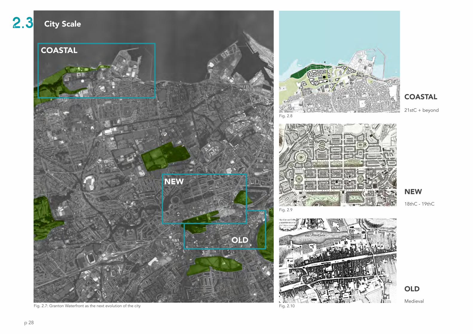
Fig. 2.7: Granton Waterfront as the next evolution of the city
2.3
p 29
City Scale
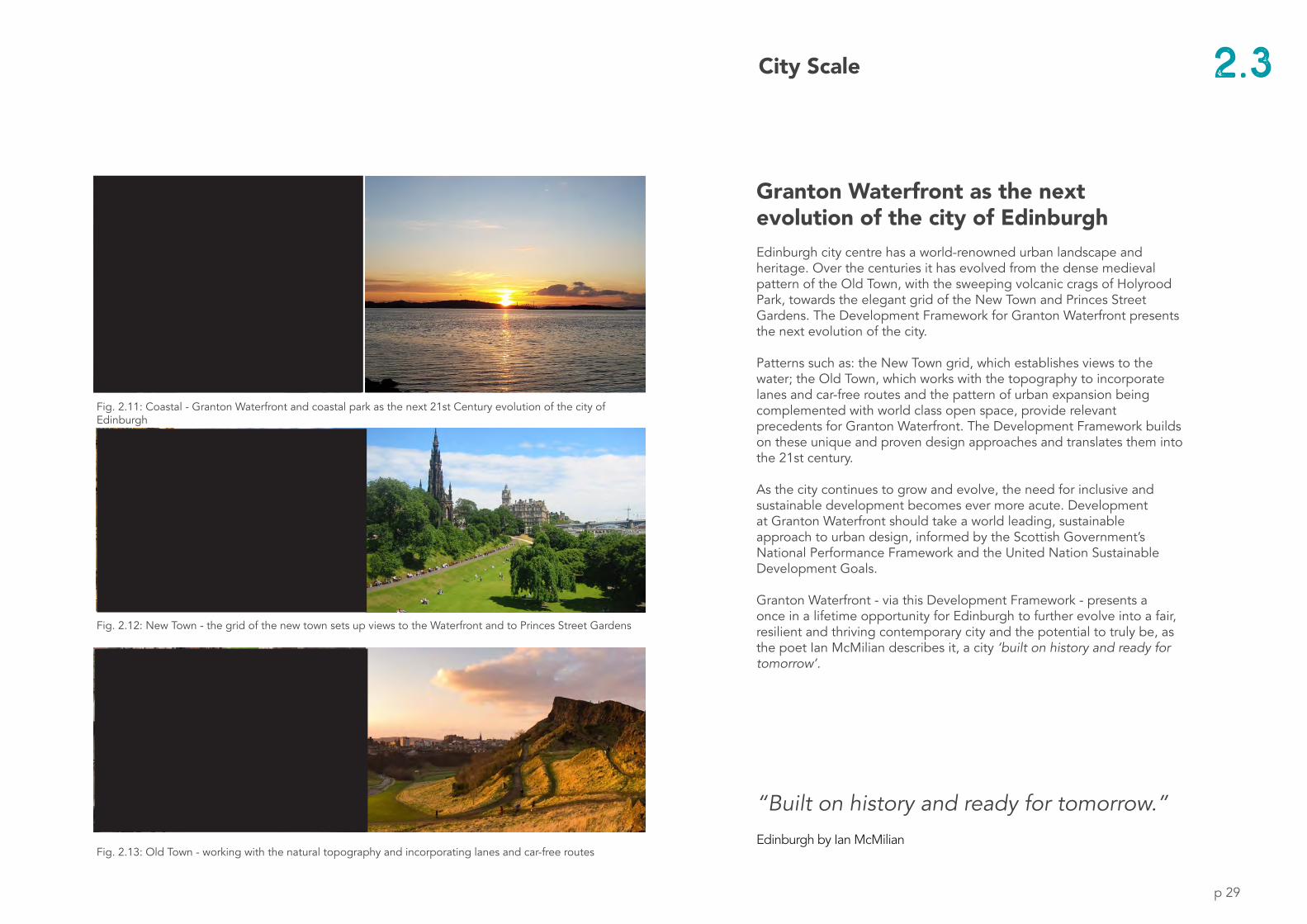
Granton Waterfront as the next evolution of the city of Edinburgh Edinburgh city centre has a world-renowned urban landscape and heritage. Over the centuries it has evolved from the dense medieval pattern of the Old Town, with the sweeping volcanic crags of Holyrood Park, towards the elegant grid of the New Town and Princes Street Gardens. The Development Framework for Granton Waterfront presents the next evolution of the city.
Patterns such as: the New Town grid, which establishes views to the water; the Old Town, which works with the topography to incorporate lanes and car-free routes and the pattern of urban expansion being complemented with world class open space, provide relevant precedents for Granton Waterfront. The Development Framework builds on these unique and proven design approaches and translates them into the 21st century.
As the city continues to grow and evolve, the need for inclusive and sustainable development becomes ever more acute. Development at Granton Waterfront should take a world leading, sustainable approach to urban design, informed by the Scottish Government’s National Performance Framework and the United Nation Sustainable Development Goals.
Granton Waterfront - via this Development Framework - presents a once in a lifetime opportunity for Edinburgh to further evolve into a fair, resilient and thriving contemporary city and the potential to truly be, as the poet Ian McMilian describes it, a city ‘built on history and ready for tomorrow’.
“Built on history and ready for tomorrow.”Edinburgh by Ian McMilian
Fig. 2.11: Coastal - Granton Waterfront and coastal park as the next 21st Century evolution of the city of Edinburgh
Fig. 2.12: New Town - the grid of the new town sets up views to the Waterfront and to Princes Street Gardens
Fig. 2.13: Old Town - working with the natural topography and incorporating lanes and car-free routes
2.3
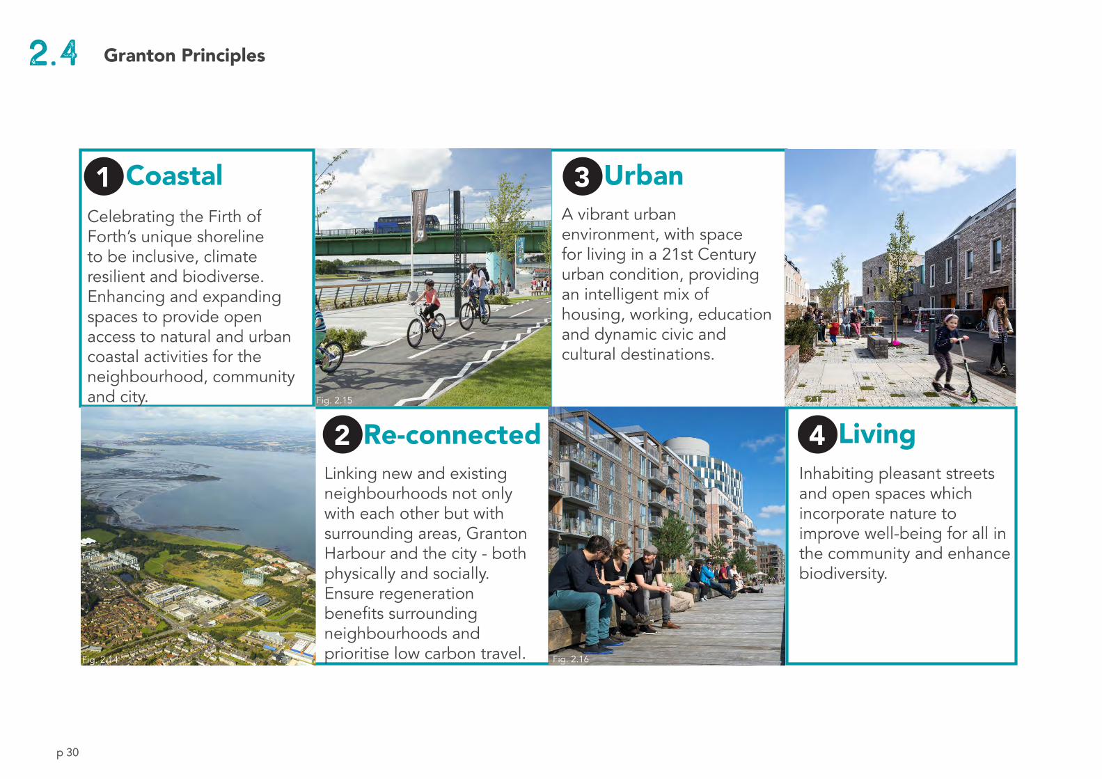
p 30p 30
1 | Coastal 3 | UrbanA vibrant urban environment, with space for living in a 21st Century urban condition, providing an intelligent mix of housing, working, education and dynamic civic and cultural destinations.
Celebrating the Firth of Forth’s unique shoreline to be inclusive, climate resilient and biodiverse. Enhancing and expanding spaces to provide open access to natural and urban coastal activities for the neighbourhood, community and city.
2 | Re-connectedLinking new and existing neighbourhoods not only with each other but with surrounding areas, Granton Harbour and the city - both physically and socially. Ensure regeneration benefits surrounding neighbourhoods and prioritise low carbon travel.
4 | LivingInhabiting pleasant streets and open spaces which incorporate nature to improve well-being for all in the community and enhance biodiversity.
1 3
2 4
2.4
Fig. 2.14
Fig. 2.15
Fig. 2.16
Fig. 2.17
Granton Principles
p 31
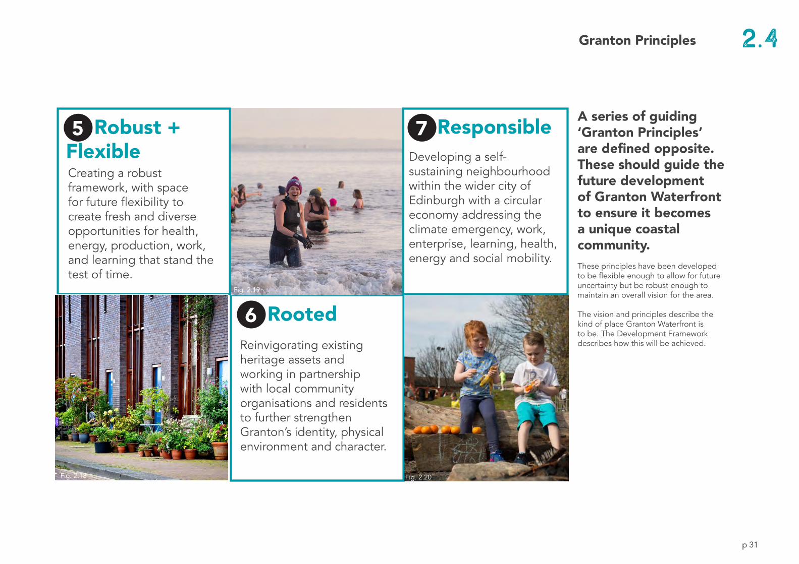
2.4
A series of guiding ‘Granton Principles’ are defined opposite. These should guide the future development of Granton Waterfront to ensure it becomes a unique coastal community. These principles have been developed to be flexible enough to allow for future uncertainty but be robust enough to maintain an overall vision for the area.
The vision and principles describe the kind of place Granton Waterfront is to be. The Development Framework describes how this will be achieved.
6 | RootedReinvigorating existing heritage assets and working in partnership with local community organisations and residents to further strengthen Granton’s identity, physical environment and character.
7 | ResponsibleDeveloping a self-sustaining neighbourhood within the wider city of Edinburgh with a circular economy addressing the climate emergency, work, enterprise, learning, health, energy and social mobility.
5 | Robust + FlexibleCreating a robust framework, with space for future flexibility to create fresh and diverse opportunities for health, energy, production, work, and learning that stand the test of time.
p 31
5 7
6
Fig. 2.18
Fig. 2.19
Fig. 2.20
Granton Principles